Article

Improving the Climate Resilience of Urban Road Networks: A Simulation of Microclimate and Air Quality Interventions in a Typology of Streets in Thessaloniki Historic Centre

1
School of Spatial Planning and Development, Aristotle University of Thessaloniki, 54124 Thessaloniki, Greece
2
School of Architecture, Aristotle University of Thessaloniki, 54124 Thessaloniki, Greece
*
Author to whom correspondence should be addressed.
Land 2023, 12(2), 414; https://doi.org/10.3390/land12020414
Submission received: 29 December 2022 / Revised: 27 January 2023 / Accepted: 30 January 2023 / Published: 4 February 2023
(This article belongs to the Special Issue Urban Form and the Urban Heat Island Effect)

Abstract

:
The improvement of the urban microclimate in the densely-built central areas of Mediterranean cities should be a key objective of integrated urban and transport planning and design in accordance with the UN Sustainable Development Goals on energy, sustainable cities, and climate action. The urban climate of cities in warm regions, already burdened by the urban heat island effect, is expected to worsen further due to the global climate crisis. This study investigates the performance of common environmental street design strategies on microclimate, thermal comfort, and air quality under extreme heat conditions in the Mediterranean city of Thessaloniki, Greece. A typology of streets was selected using criteria such as road functional classification and orientation, land uses, building height/street width ratio, the sky view factor, and the continuity/discontinuity of buildings. A conservative scenario (use of cool/photocatalytic and porous materials for sidewalks, lighter pavements, additional tree planting, installations of green roofs) and a radical scenario (pedestrianization and total traffic prohibition) of environmental design interventions were simulated using the ENVI-met 5.1 software. The research findings demonstrated that the car-free interventions combined with the use of environmentally friendly materials in the public realm could significantly reduce the heat island effect and mitigate gaseous pollutants. The perceived air temperature (Physiological Equivalent Temperature—PET index) can decrease by up to 15 °C in well-shaded locations and near building corners, while nitrogen oxides can be reduced by up to 87% when considering a more radical pedestrianization scenario. The standardization of environmental interventions following a typology of urban streets could support planners and decision-makers in detecting the appropriate solutions for improving the urban microclimate.

1. Introduction

Over the past decade, the concept of resilience in spatial sciences, architecture, planning, and transportation has gradually matured as an independent field of study that now stands next to sustainability. The idea of urban resilience follows and complements that of sustainability, recognizing that instead of a static state of ecological equilibrium, there is a complex web of dynamic interactions between all urban phenomena [1,2,3]. Urban resilience can be broadly defined as the capacity of an urban system to withstand stress, recover from disturbances and prepare for future shocks [4]. Such shocks include the COVID-19 pandemic, the global climate crisis, and the emerging energy crisis, which have already had a significant impact on urban systems [5,6].
Globally, cities are now required to innovate to adapt to the multiple disruptions brought about by this combined wave of challenges. Concepts such as ‘risk management’, ‘uncertainty’, ‘vulnerability’, and ‘adaptability’ have now entered the lexicon of urban planning, governance, and design for good. At the street level, transport planning interacts with urban and architectural design. The joint interaction ultimately generates the streetscape and the associated environmental conditions that affect human comfort and health. Urban climate resilience has mostly been studied at the city-wide level. For example, Tyler and Moench [7], by reviewing these studies, propose a framework of principles in which city structure, functions, and management agencies/organizations can be transformed to approach it. According to this framework, the climate resilience of the city is enhanced by adapting all the “subsystems” of the city, i.e., the buildings, the infrastructures, and of course, the outdoor spaces, to the changing local climate.
Yet, climate resilience at the small and local scale of the street and block is much less defined, understood, and standardized. For several urban space thinkers [8,9,10], the street is the most important outdoor space of the city when considering both a social systems view and a transport planning perspective. Modern cities are designed for the car, with the asphalt road surface taking up the lion’s share of the public space compared to that allocated to sustainable transport modes such as walking, bicycles, buses, and trams. In hot-dry climates, such as the Mediterranean, the combination of high air temperatures and prolonged sun exposure can be detrimental to human health [11]. Pedestrians and cyclists have to deal not only with the severe urban heat island (UHI) effect during a heat wave [12] but also with the localized sources of additional convective and radiative heat fluxes, such as vehicles and overheated urban surfaces. For example, the surface temperature of asphalt on a hot day can exceed 50 °C [13], which, combined with vehicular heat emissions, has a negative effect on thermal comfort [14]. This paper presents the results of a typological study on passive design strategies to improve the climate resilience of urban transport systems with an emphasis on microclimate, thermal comfort, and air quality of the urban road network.
There are now several urban microclimate studies that focus on the street network of Greek cities. For example, Chatzidimitriou and Yiannas [15] studied a section of the historical center of Thessaloniki with simulations and field observations and then simulated typical idealized street cross-sections to draw conclusions about the most favorable orientations and the most suitable street widths relative to the height of buildings. Vassiliades, Savvides, and Buonomano [16] studied the possible negative effects of the installation of photovoltaic panels on building facades on the thermal comfort of pedestrians in Thessaloniki and Naples with simulations. Tseliou and Tsiros [17] examined different scenarios of urban interventions in three typical public spaces of Athens for a typical winter and summer day with simulations. Kouklis and Yiannakou [18] investigated the effect of the urban form on the microclimate of the center of Thessaloniki. Vartholomaios and Kalogirou [19] utilized the Ladybug Tools environmental analysis library to simulate the microclimate of the old Venetian port in Chania and propose optimized shading arrangements for different orientations.
However, studies that simultaneously examine microclimate, thermal comfort, and air quality from the perspective of urban transport systems have been more limited. For example, Girgis, Elariane, and Elrazik [14] combined microclimate simulations with analytical CFD wind simulations to estimate the effect of vehicle exhaust heat on pedestrian thermal comfort in Cairo. Shashua-bar, Tsiros, and Hoffman [20] studied microclimate improvement strategies in the streets of Athens using the Green CTTC model in which thermal loads from automobile traffic are taken into account. Krüger, Minella, and Rasia [21] studied the effect of urban geometry on thermal comfort and air quality in Curitiba, Brazil. Schaefer et al. [22] combined questionnaires, hand-held instruments, and microclimate simulations to map thermal comfort and air quality as both objectively observed and subjectively experienced in a Dortmund neighborhood on one day during a heat wave.
This paper presents the results of a typological study on passive design strategies to improve the climate resilience of urban transport systems with an emphasis on microclimate, thermal comfort, and air quality of the urban road network. This multidisciplinary work focuses on the center of Thessaloniki, Greece, where a typological investigation of the road network is conducted in terms of urban canyon orientation and geometry, role in the street hierarchy, location in the urban fabric, and neighboring building uses. This is done to test the resilience-building capacity of passive design strategies when applied to the most common type of public open space, the street. The study utilizes the ENVI-met 5.1 simulation software, which has been used and validated in similar studies [23,24,25,26,27,28,29].
Here we consider three types of roads: (i) an arterial road, (ii) a collector road, and (iii) a local road, both in straight sections of roads and in intersections. We employ the ENVI-met 5.1 software to simulate the microclimate and the dispersion of gaseous pollutants. The software is fed (forcing) with terrestrial data from a permanent weather station and an air quality monitoring station, both in proximity (800 m and 500 m, respectively). Traffic data is acquired from the Sustainable Urban Mobility Plan (SUMP) of Thessaloniki. We then map the Physiological Equivalent Temperature (PET) and the dispersion of gaseous pollutants and greenhouse gases from the simulation results. Simulations are run for the existing situation and for a resilience improvement scenario with additional tree plantings, the use of cool materials and coatings, and planted roofs. Therefore, the originality of the research and its differentiation from previous microclimate studies can be summarized in the following points:
(1)
The work simultaneously studies microclimate, thermal comfort, and air quality using simulations and ground data for the Greek Mediterranean climate;
(2)
Emphasis is placed on issues of urban climate resilience, looking at the hottest day and time of the decade, i.e., an extreme condition that may become more frequent in the future;
(3)
Emphasis is placed on the typological analysis of the street. That is, instead of studying a specific outdoor space, a part of an urban fabric, or an idealized street model, real street examples are used. Their systematic study and comparison allow complex conclusions to be drawn that may not be obvious in research focusing on a single study area.
The remainder of the paper is structured as follows: Section 2 describes the study areas and the methodological approach, Section 3 presents the results of microclimate simulation and the comparative analysis of environmental upgrading scenarios, and Section 4 provides a discussion of the findings and the conclusions concerning the policy implications and the study’s limitations and prospects.

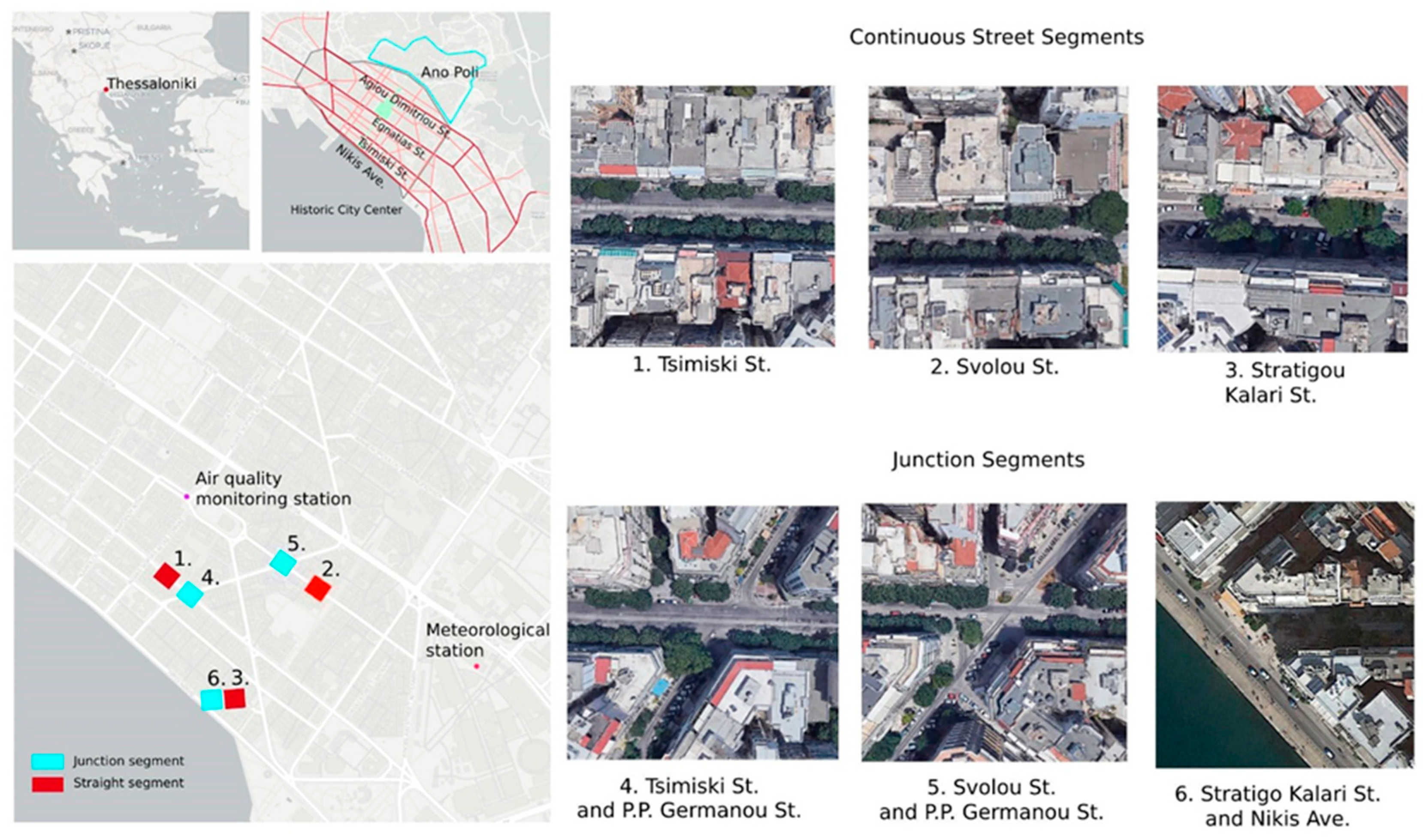
2. Study Area and Research Methodology

Thessaloniki is a mid-sized city with a densely-built commercial center and limited public open spaces and vegetation. It has a typical Mediterranean climate (CSa type according to Koppen-Geiger classification) with mild-wet winters and dry-hot summers. The percentage of accessible green public spaces is lower than most European cities at just 2.7 m2 per capita, with a minimum service level of 4.3 m2 per capita suggested by the 2015 Strategic Environmental Impact Study of Thessaloniki. Unlike many similar walled Mediterranean cities, Thessaloniki’s intra-muros urban tissue largely comprises of piecemeal post-war developments arranged in compact urban blocks. The exception is the historic “Ano Poli” (Upper Town), where the vernacular urban fabric is still preserved. The city center layout was largely influenced by Ernest Herbrard’s plan for Thessaloniki after the great fire of 1917 destroyed much of its core. The post-war urbanization of Greece led to an overall increase in urban densities through the prevalence of the multifamily apartment building typology of “Polykatoikia,” which rapidly replaced most of the pre-existing building stock. The compact urban blocks are 6 to 8 stories high, with the ground floor being used for commercial activities. The upper floors are a mix of residences, offices, and other tertiary sector uses. The urban layout deviates from a strictly rectangular grid with many blocks having trapezoidal shapes, which are also reflected in the shape of floor plans as well [30].
The resulting urban fabric is not only short on vegetation and open spaces but also presents a challenge for sustainable transportation. The public transport system of the city is based solely on the bus network, a fact that makes the city lag behind many other European cities of similar size and urban form [31]. Only main arteries can accommodate bus lanes, while the cycle path network is limited and fragmented. Many local streets are not friendly to pedestrians, as on-street parking is ubiquitous, and sidewalks are often occupied by signage, dumpsters, trees with improper clearance, outdoor seating, and other permanent and semi-permanent obstacles [32]. Over the past few years, there have been several cases of pedestrianization of local streets, while notable progress has been observed in the development of Sustainable Urban Mobility Plans (SUMPs) and Urban Accessibility Plans (UAP) for the Municipalities that form the urban conglomeration. It’s also worth mentioning that the completion of Thessaloniki’s Metro line in 2024 and the expansion of the ring road with a flyover route are expected to significantly relieve traffic congestion. Yet, the pedestrian and cyclist experience is still relatively poor for a large portion of the city’s street network due to increased noise levels, vehicular exhaust fumes, and increased air temperatures due to the UHI-affected microclimate.
Our position as researchers is the improvement of pedestrian environmental comfort and subjective experience should constitute an integral aspect of SUMPs and especially UAPs and associated policies, plans, and design guidelines. With globally rising temperatures, active modes of transport such as walking and cycling may become less favorable, particularly in hot climates. The simulation-based approach presented here allows us to predict and design not for the average climate but for the extreme conditions of a heat wave. Through this study, we can understand the theoretical limits and capabilities of bioclimatic design interventions to improve the resilience of our urban transport infrastructure.
The study focuses on the city center of Thessaloniki and specifically on six 100 × 100 m2 areas corresponding to a typology of streets with different characteristics. The research methodology consists of the six following steps:
(1)
Selection of six road-section types based on urban form and structure, as well as spatial and transportation criteria;
(2)
Collection and preparation of meteorological, traffic, and air quality data for the extremely hot day of the period (2012–2022);
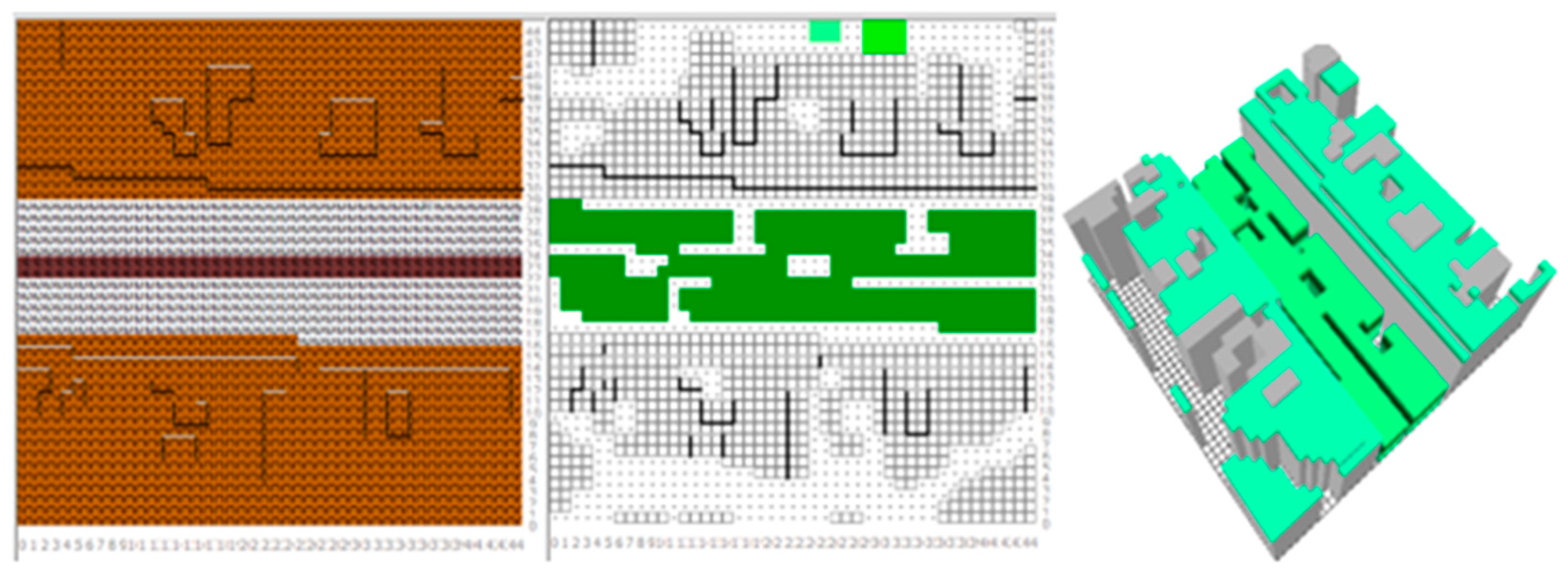
(3)
Simulation of the existing environmental conditions in the selected highway sections with ENVI-met 5.1 and mapping of the following parameters: air and surface temperature, PET thermal comfort sensation, concentrations of NOx, PM2.5, and PM10;
(4)
Design and simulation of a “conservative intervention” scenario for the six selected road sections and a “radical intervention” scenario that involves the pedestrianization of a main urban artery. Mapping of the same variables as in the previous step;
(5)
Mapping and comparison of results from Steps 3 and 4 to quantify the relative impact of the proposed intervention scenarios on the examined environmental parameters.
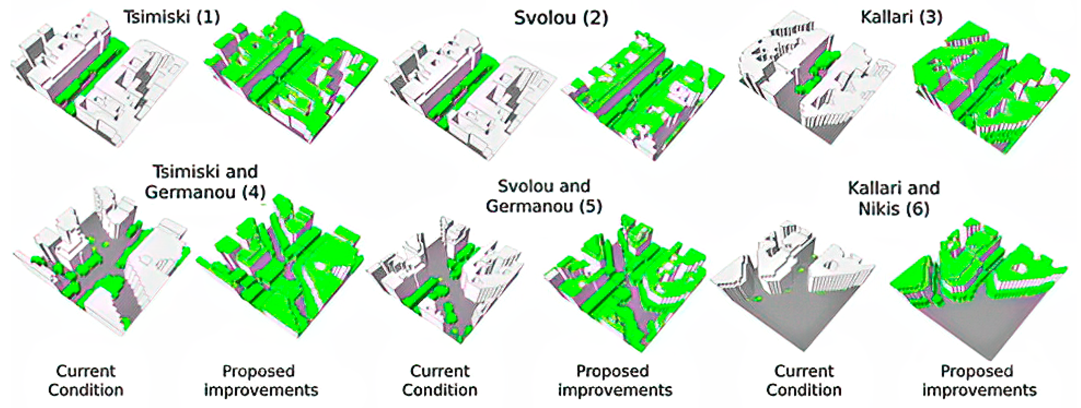
We manually picked the six areas because they comprise a variety of morphological and functional street configurations (eleven different types of streets) based on the following criteria:
(1)
The street network hierarchy: one artery (Ioannou Tsimiski Street), one collector (Alexandrou Svolou Street), and one local and recently (2019) pedestrianized street (Stratigou Kallari Street) are considered;
(2)
The continuity-discontinuity of the building volume and the existence of intersections along the streets: A pair of a continuous street segment and a junction segment is selected for each of the three examined streets;
(3)
The variance in street geometry and land use: The selected streets have different directions in relation to the North, and at the same time, they are intersected by other streets with different directions as well. The selected street segments have different degrees of sky openness, as described by the building Height-to-Street Width (H/W) ratio and the average Sky View Factor (SVF): The H/W ratio varies among the three streets, but the SVF also varies by both the presence of tall vegetation as well as from the greater openness of the crossroads, which the H/W ratio does not consider. The streets also have a varying mixing degree of ground floor uses (e.g., retail, leisure, and services).
The six selected areas allow a standardization of the microclimate simulations so that the results are comparable between them. Figure 1 shows the six areas of interest, which correspond to either a continuous street segment (cases 1, 2, and 3) or a junction segment (cases 4, 5, and 6). The intersection segments of Tsimiski and Alexandrou Svolou Streets include Palaion Patron Germanou Street, while the intersection segment for Stratigou Kallari Street includes Nikis Avenue. The study considers other smaller streets that are within the boundaries of the selected areas. The typological characteristics of the 11 examined streets are presented in detail in Table 1, Table 2 and Table 3.
We obtained the meteorological data for the study site and for the period 2012–2022 from the permanent weather station of the National Observatory located at the International Exhibition of Thessaloniki, which is within walking distance from the examined street segments (800 m). We then analyzed the collected data to identify the hottest day and hour of the decade, which was 3 August 2021, at 16:00, with the air temperature reaching 40.8 °C. Since the study is concerned with urban climate resilience, the microclimate we ran simulations for was for this extremely hot day and presented the results for the hottest hour. Background air pollution data (NO, NO2, SO2, O3 and PM2.5, PM10) were obtained from the permanent monitoring station at St. Sofias, located near the study areas (500 m). Traffic loads per vehicle category were obtained from Thessaloniki’s SUMP.
In order to make the simulation results comparable, we standardized the constant input data (e.g., meteorological data, date/time of simulation, material and vegetation properties, and model dimensions). ENVI-met simulates the urban space in a 3D voxel architecture, which could take any dimensions we wanted. Here, the 100 × 100 m2 study area was transformed into a grid of 45 × 45 × 33 voxels, corresponding to real-world dimensions of 2.22 × 2.22 × 1.5 m3 per voxel. The model space was enveloped within a nesting grid of 4 additional voxels, scaled in size the further they were from the model’s area. This was necessary for the correct execution of the fluid dynamics model of ENVI-met. The 3D models were rotated vertically to include the main axis of the road in a horizontal or vertical layout. This was done to decrease the pixelation effect of angled geometries represented in ENVI-met’s gridded system.
We then drew the examined areas in their existing state and fed the input data into the program (Table 4). Air pollutant dispersion and concentration levels were calculated by ENVI-met by considering the background and traffic-generated pollutants according to recorded loads per vehicle type. We entered the meteorological data by a simple forcing of the model, using maximum and minimum daily temperature/humidity values, from which the corresponding hourly values were derived. We determined the spatial distribution of materials and vegetation by field observations while their thermophysical and morphometric properties were defined through an informal market survey of local suppliers via phone and e-mail (Table 4).
We ran simulations for the existing state of the six street segments for 3 August 2021, and for a simulated period of 25 h, beginning from 12:00 PM of the previous day. Then we post-processed the simulation results using BIO-MET to calculate the PET thermal comfort sensation for a 60-year-old woman in average clothing (clo = 0.8) and in a brisk walking activity (MET = 3.0). This human profile was chosen in order to study the effects on a theoretically more vulnerable person, as indicated by relevant research on the relationship between heat-related health risks, human age, and sex [33,34]. All simulation results, including the PET thermal comfort sensation, were mapped at the height of 1.35 m above the ground surface.
The next step was to alter the 3D configuration models of the six street segments using a standardized set of environmental interventions (conservative scenario) and run a second set of simulations. These interventions included the following (Figure 2):
  • Replacement of asphalt pavement with high reflectivity pavement mixture;
  • Replacement of sidewalk slabs with cool and photocatalytic pavers on a concrete base. Cool materials have a high solar reflectance and heat emittance, but dust and dirt can reduce their effectiveness. Photocatalytic materials are “self-cleaning” since they can decompose such particles using ultraviolet solar radiation. A paver that is both cool and photocatalytic combines both attributes;
  • Replacement of trees in poor condition with new deciduous trees of medium size in suitable tree planters. Trees are simulated at full growth. It is noted that many of the elm trees, which are present in abundance, are mainly on I. Tsimiski and Alexandrou Svolou Streets are in poor condition, as they exhibit signs of rot and infestation by the elm beetle. Also, most of the trees were planted seven decades ago, and quite a few have been badly pruned;
  • New plantings of medium-sized deciduous trees where possible, without drastically altering the street layout and ensuring adequate distances from other trees and buildings;
  • Installation of lightweight extensive green roofs on surrounding buildings planted and planting with drought-tolerant bushy and herbaceous vegetation.
The standardized parameters that were used in the second set of simulations are shown in Table 5.
The next step was to design and simulate a “radical” intervention scenario that involved the pedestrianization of a major road artery (Tsimiski Street, case 1). This scenario nullifies most of the locally produced vehicular emissions and changes the layout of the street by replacing asphalt (albedo 0.20) and sidewalk slabs (albedo 0.30) with porous, photocatalytic, and cool pavers (albedo 0.80), allocating more public space to pedestrians and cyclists and providing space for additional trees. These interventions maximize natural street shading and cooling of the street surfaces using passive methods that do not consume energy (Figure 3).
The selected pavers are porous and are installed on a sand substrate, with the exception of street segments reserved for any residual vehicular traffic (e.g., urban logistics, maintenance, and emergencies) where the substrate is still concrete. This renders a large portion of the street surface permeable to water which helps in restoring the urban water cycle and reducing stormwater run-off. The increased porosity of the pavers allows the material to trap water and air bubbles, mimicking, to a degree, the thermophysical properties of soil. Photocatalytic (self-cleaning) coatings reduce the accumulation of dust and particles on the pavers, which helps maintain their reflective properties. An additional row of 15 m high deciduous trees is also planted on a green strip in the middle of the road.
We run a second batch of 25-h simulations of the “conservative” scenario for the six selected sections (both straight and junction segments) and the “radical” environmental upgrade scenario for 3 August 2021. With the exception of changed parameters (e.g., vegetation, materials, and layout), the rest of the simulation parameters remained the same.
We then visualized and compared the simulation results using LEONARDO for ENVI-met 5.1. The reported results were: (i) air temperature, (ii) surface temperature, and (iii) PET thermal comfort sensation, distribution of nitrogen oxides (NOx), and distribution of PM2.5 particulate matter for the warmest time of day in the period 2012–2022 (3 August 2021, 16:00) with a recorded ambient temperature of 40.80 °C. Both the current condition and the upgrade scenarios were presented, and the calculated differences between the examined parameters were also mapped to arrive at meaningful conclusions.

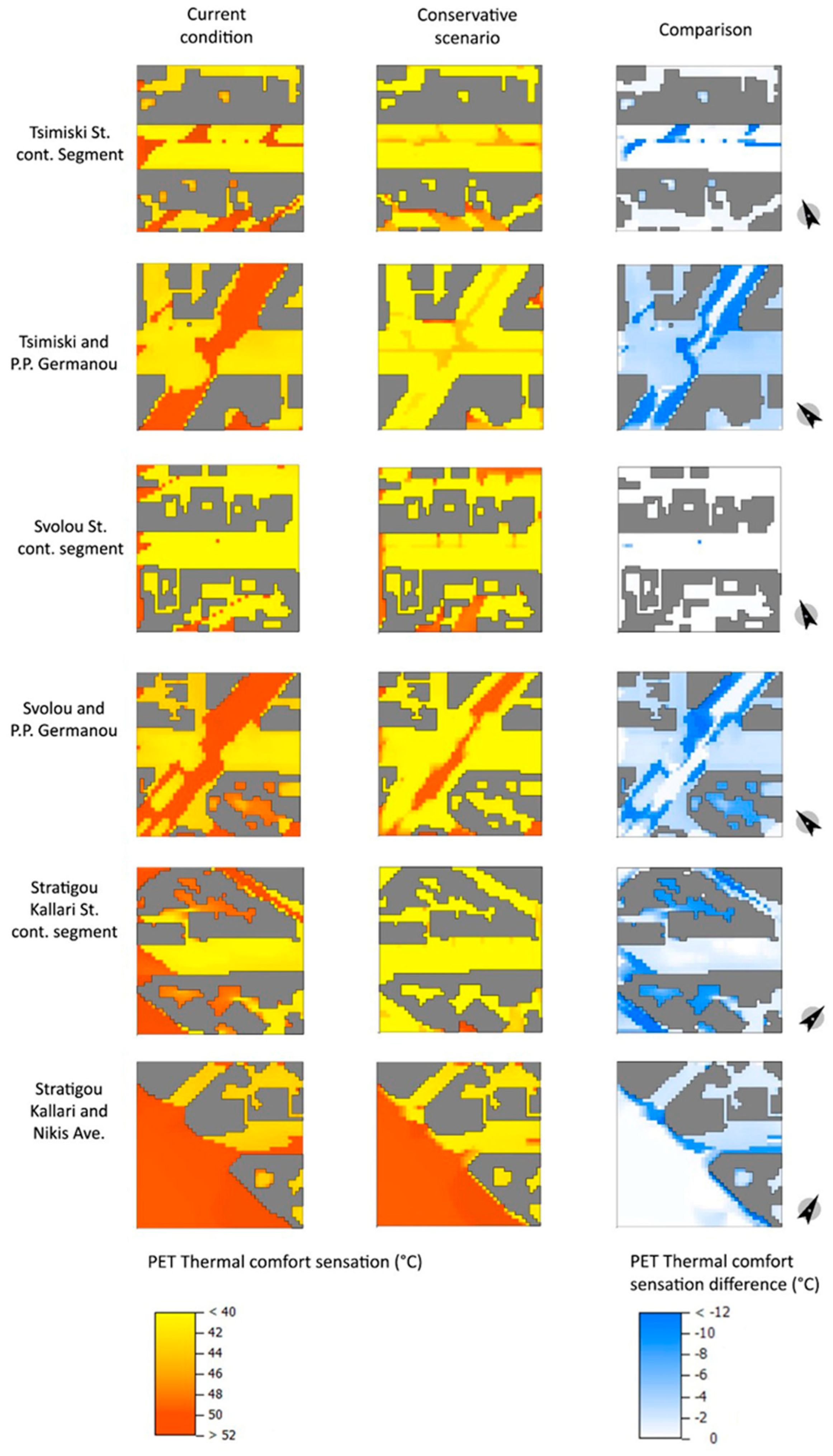
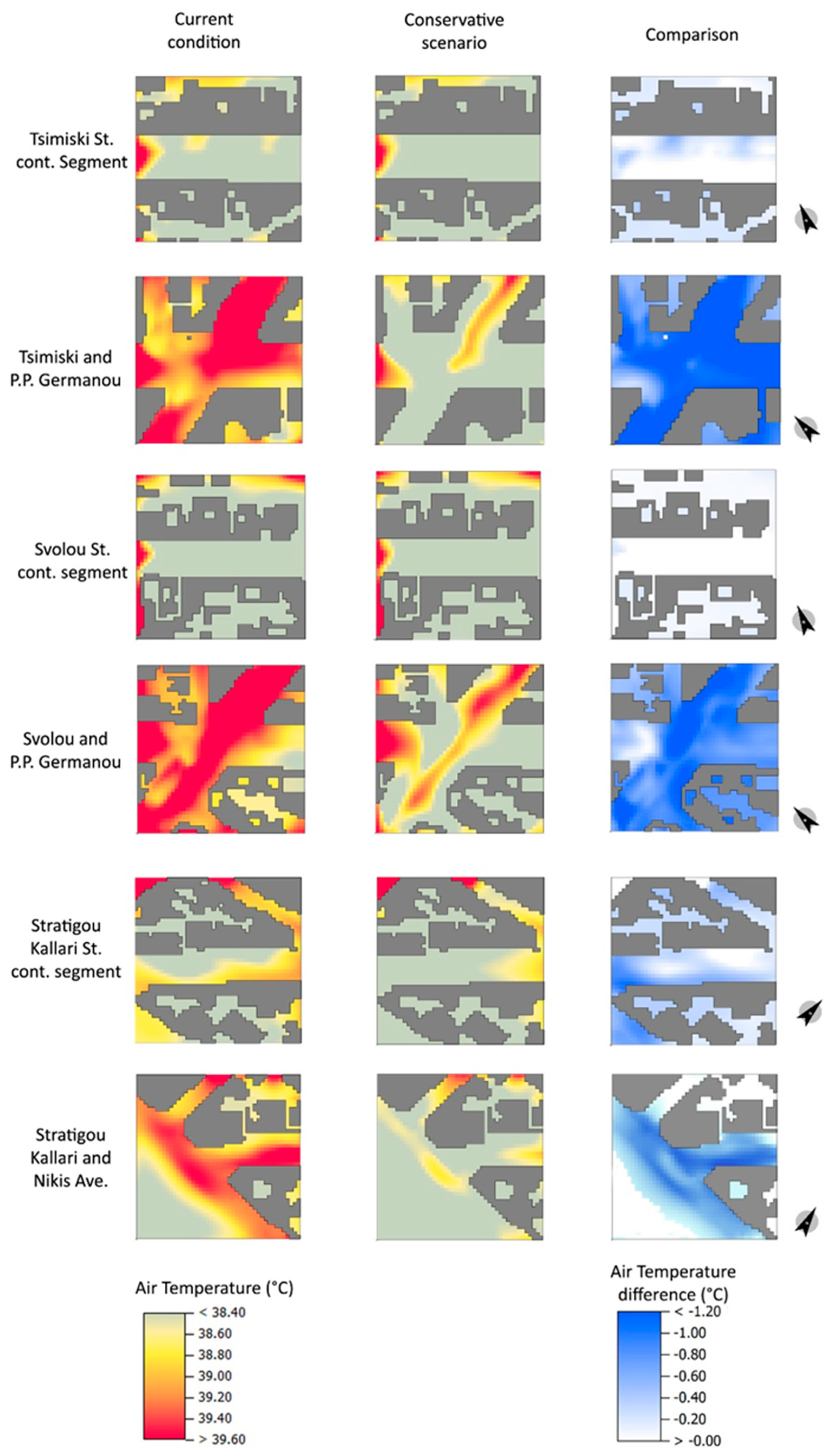
3. Results and Scenarios Comparative Analysis

The presentation and analysis of the simulation results are divided into two subsections: one for the “conservative” environmental intervention scenario and another for the “radical” intervention scenario.

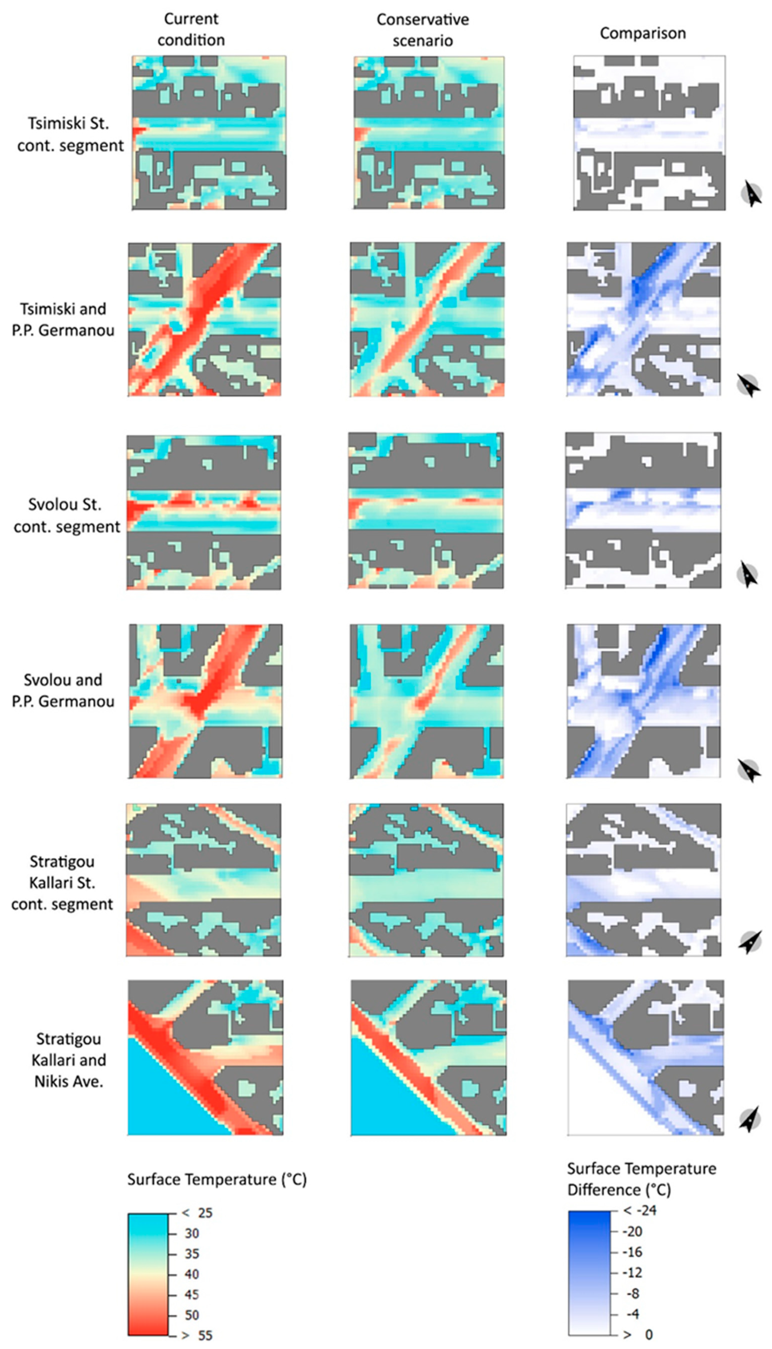
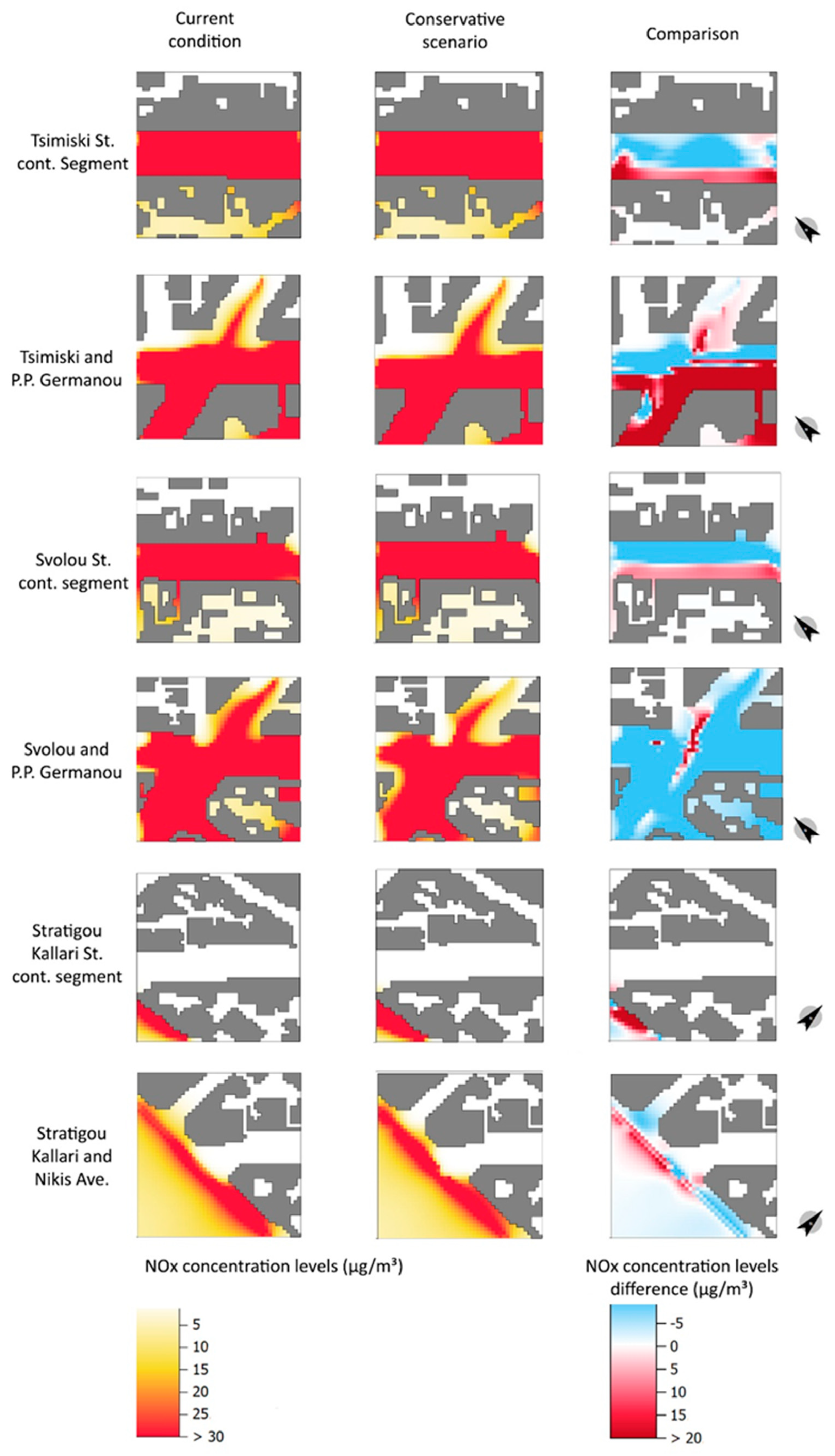
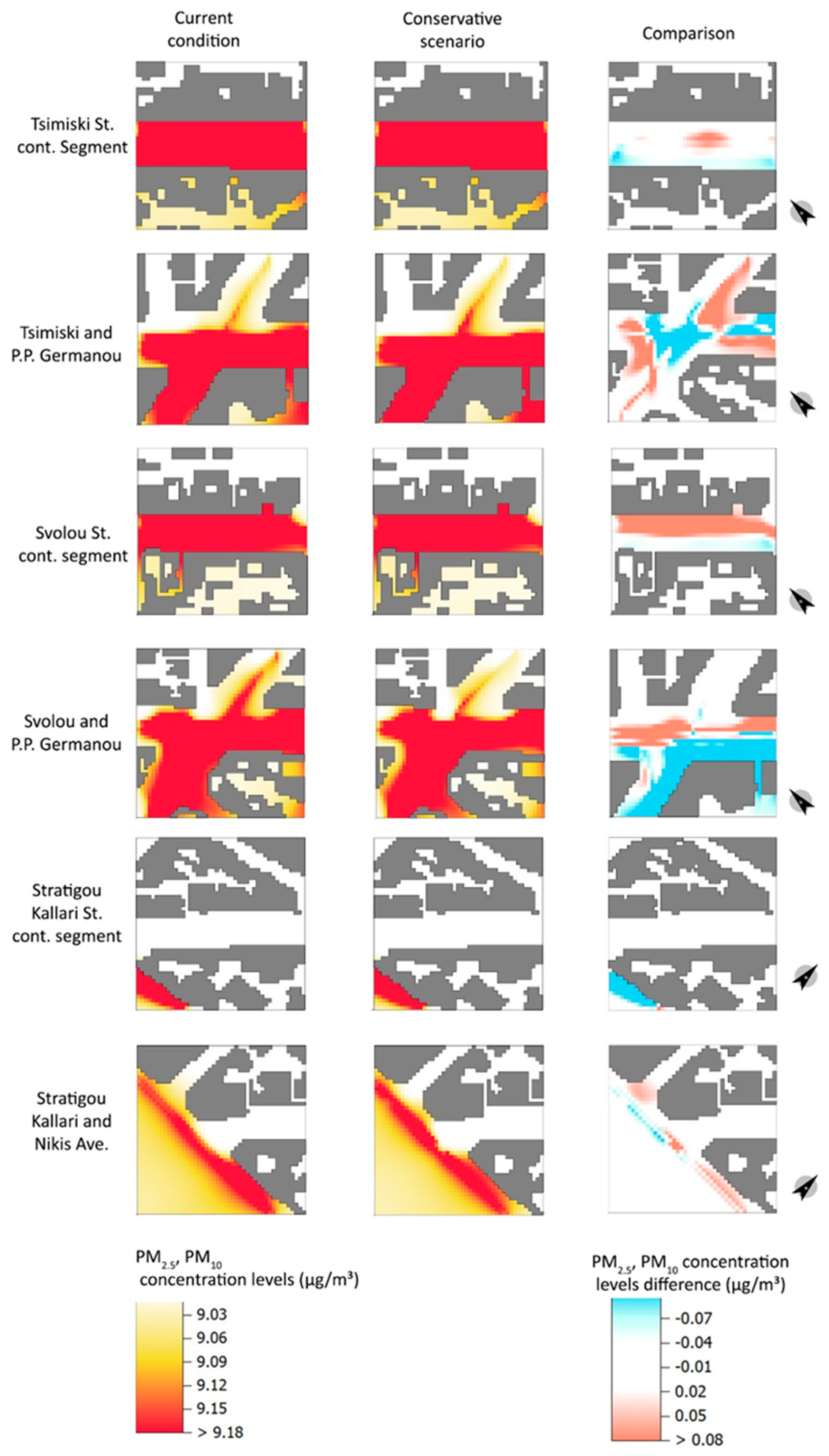
3.1. Comparison of Simulation Results between the Existing Condition and the “Conservative” Scenario

This section presents and comments upon the simulation results with respect to the “conservative” environmental intervention scenario in terms of vegetation planting, PET thermal comfort sensation (Figure 4), air temperature (Figure 5), surface temperature (Figure 6), distribution of nitrogen oxides (NOx) (Figure 7), and PM2.5 and PM10 particulate matter (Figure 8) for the warmest hour and day of the period 2012–2022 (3 August 2021, 16:00). Both the absolute values and their comparison are presented in these figures.
The results reveal the influence of the relative lack of tall vegetation in P.P. Germanou St. and Nikis Avenue and the complete lack of vegetation in several local streets (Konstantinou Palaiologou, Iktinou, and Spyrou Loui) on increased thermal stress (Figure 4). In such cases, the improvement of PET thermal comfort sensation was significant under vegetation shade when considering the intervention scenario. The biggest reductions in perceived air temperature were recorded in P.P. Germanou St. and Nikis Avenue and could reach 12 °C under shade. On the other hand, Stratigou Kallari St., which has recently been pedestrianized, and Svolou St. showed negligible improvements in PET thermal comfort sensation due to the fact that they were already shaded significantly by trees. Here it is noted that the trees for all cases were simulated at mature height, including the newer trees planted in Stratigou Kallari. Tsimiski St. demonstrated moderate improvement of around 7 °C on average due to the street already having a row of trees on both sidewalks. Yet, even with two rows of trees, portions of asphalt received little shade (Figure 6). It was also found that despite the beneficial effect of the sea breeze at the coastal Nikis Avenue, the lack of shade from trees and structures significantly increased the feeling of thermal discomfort.
Extreme thermal stress levels could be observed above unshaded asphalt for a person with prolonged exposure to the sun, as PET thermal sensation could reach 50 °C in such locations. Empirically, such high temperatures could be found inside sun-exposed parked cars and signify an increased risk of heat stroke. It is worth noting that even under the shade, thermal comfort conditions were still unsuitable for a long stay (sensible temperature around 40 °C), but shaded areas could allow a person to cross the road while receiving less thermal stress, even during the hottest hour of the decade. However, for longer stays, “conventional” microclimatic design measures may be proven inadequate, especially in the face of global climate change and aggravated UHI effect.
Exposed asphalt could reach surface temperatures of 55 °C, although spots where 60 °C were also observed in the most sun-exposed locations (e.g., Nikis Avenue, P.P. Germanou St., I. Kouskoura St.). In the streets with tree coverage, much lower asphalt surface temperatures were observed. The use of reflective asphalt mixtures and porous, photocatalytic, and cool pavers seemed to ameliorate the extreme surface temperatures, which could still reach 30–45 °C, depending on whether they were shaded or not (Figure 6).
The proposed interventions resulted in an air temperature drop of approximately 1 °C (from 39.5 °C to 38.5 °C) in the cases of P.P. Germanou St. and Nikis Avenue, although changes were smaller or negligible in other streets. The air temperature was relatively inelastic to local environmental improvements due to the constant mixing of air masses within the urban canyons. Air mixing seemed to occur in the narrower local streets of Konstantinou Palaiologou, Spyrou Loui, Iktinou, Morkentau, and L. Margariti as well, which share similar air temperatures. The effect was more noticeable in areas with significant improvement potential, especially where sun-exposed asphalt prevails (Figure 5 and Figure 6). The center of street junctions could be a particularly problematic area (e.g., the P.P. Germanou St. intersections with Svolou St. and Tsimiski St.).
The comparison visualizations revealed that the greatest improvement was shown by P.P. Germanou at the intersections with A. Svolou and Tsimiski, particularly where additional trees are planted. The significant effect of sun and shade on thermal comfort was well documented in the relevant literature, so this came as no surprise. Tsimiski and A. Svolou already had significant tree cover on the sidewalks, and improvements in thermal comfort were more limited. They came mainly from the improvement of the thermo-optical properties of the materials, the denser tree cover, and, to a lesser extent, from the planted roofs. In the case of the recently pedestrianized Kallari St., there was some potential for further but limited improvement for the examined intervention scenario. It seemed that additional shading of the road, by natural or artificial means, was required to increase its bioclimatic responsiveness toward the expected increase in frequency and intensity of heat waves in the coming years.
However, shading was not possible everywhere. In the case of Nikis Avenue, the possibilities for additional shading were limited. The old waterfront was not suitable for tall vegetation, and the installation of umbrellas would limit the view of Thermaikos. In addition, the intersections of wide streets running at an angle of 45° (e.g., Tsimiski and P. P. Germanou) could hardly be shaded by trees or artificial structures. Therefore, it makes sense to explore advanced urban floor cooling techniques that do not burden the occupant with increased thermal loads from reflections and emissions but instead improve the pedestrian’s environmental sensation. It is typically mentioned that the combination of cool materials in road floors with parallel photocatalytic properties is now imperative since photocatalytic materials are self-cleaning and do not easily lose their reflective properties. The use of cool materials allows for limiting the visual discomfort of pedestrians due to their selective reflectivity. However, special attention is needed in their placement so that the pedestrian is not further thermally burdened by the reflected radiation. Therefore, the most suitable materials should be porous because, on the one hand, the increased roughness diffuses the reflections more evenly, and on the other hand, it increases the thermal insulation capacity of the materials due to the trapping of air bubbles as well as the cooling by evaporation of water vapor from the surface of the floor. Consequently, the “ideal” paving material for the examined Mediterranean climate should be cool, photocatalytic, permeable, and porous.
The installation of green roofs mostly contributed to roof shading and insulation and had a limited effect on-street cooling, mostly due to the increased shading provided by shrubs. The air temperature inside the streets did not seem to be affected by green roofs. It was also noted that several of the buildings, due to their old age, could not be loaded with large volumes of soil, which was why the perimeter planting of shrubs was proposed as an alternative. The rest of the roofs could either be planted with low-lying vegetation with the minimum amount of required soil, or they could be sealed with cool, highly reflective, or thermochromic coatings.
Finally, regarding air quality, it was found that the particulate matter produced by vehicles (PM2.5/PM10) fell short of those recorded by the pollutant measuring station (Figure 7), but the exact opposite happened with Nitrogen Oxide (NOx) concentrations (Figure 7). Interestingly, denser tree planting altered local wind patterns and the distribution of air pollutants, resulting in a higher concentration of pollutants below and around the tree canopy and near building facades where wind decelerated. The opposite happened where the wind accelerated, either due to unobstructed movement or due to the building corner effect and the Bernoulli effect in narrower streets. In such cases, pollutant concentrations were smaller than the background levels. The increased entrapment of air pollutants was observed in the improved cases in all the examined areas except Nikis Avenue, which lacks vegetation, and Stratigou Kallari, which is a pedestrian street. This means that any intervention that increases shading but limits urban ventilation, such as extended tree plantings, should be accompanied by actions to reduce air pollutant emissions from car traffic. This can be done either through the gradual electrification of vehicular traffic or through smart mobility planning that encourages sustainable modes of transport over the car.

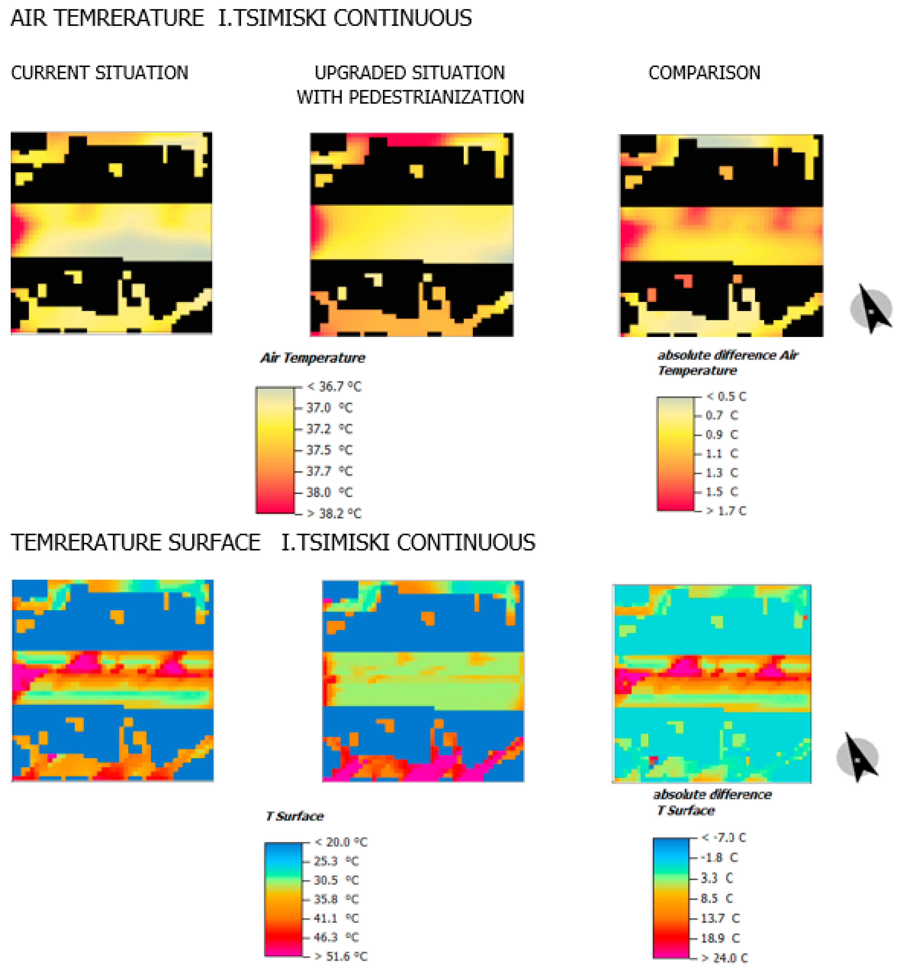
3.2. Comparison of Simulation Results between Existing Condition and “Radical” Intervention Scenario

The “radical” intervention scenario focuses on Tsimiski St., which is the main artery running through Thessaloniki’s shopping district. Its partial or even complete pedestrianization has been a topic for debate over the past few years, and the exclusion of car traffic has been proposed by Thessaloniki’s Sustainable Urban Mobility Plansas, a potential strategy for 2030, along with other transport network modifications that accommodate such change. Thus, it becomes interesting to study an additional “radical” scenario that further improves the climate resilience of Tsimiski St. by removing car traffic, increasing the number of trees and the area of unsealed soil, and replacing the asphalt and sidewalk slabs with porous, photocatalytic and cool materials. Furthermore, this scenario allows us to examine the condition where both air quality and thermal comfort improve, in contrast to the “conventional” scenario, which demonstrated an increase in pollutant concentrations due to the additional tree plantings. Here we study this “ideal” scenario of full pedestrianization at a 100 m continuous street segment of Tsimiski St., which:
(1)
Maximizes natural street shading with targeted tree plantings and further reduces surface temperatures since the proposed pavers can be used in the entirety of the street surface;
(2)
Reduces air pollutants produced by vehicles and the street’s energy footprint since the proposed interventions passively reduce the dependency on air conditioning in the lower building floors without consuming additional energy (e.g., through fan-forced ventilation and cooling installations such as water curtains, downdraft towers, and mist sprinklers);
(3)
Allows additional room for a cycle path without limiting the street area reserved for pedestrians.
The following interventions were considered:
  • Total removal of vehicular travel and complete replacement of the asphalt (albedo 0.20) and sidewalk slabs (albedo 0.30) with cold, photocatalytic, and porous materials with a high reflectivity coefficient (albedo 0.80);
  • Placement of an additional row of 15 m tall deciduous trees along the middle of the road;
  • Replacement of existing old or problematic trees with 15 m tall deciduous trees;
  • Installation of lightweight extensive green roofs on surrounding buildings planted and planting with drought-tolerant bushy and herbaceous vegetation;
The simulation results for the “radical” scenario are presented in Figure 9, Figure 10, Figure 11 and Figure 12. Furthermore, the median and maximum values for the current condition and the “conservative” and “radical” scenarios are calculated from the entire simulation grid (Table 6 and Table 7). This allows for a more quantified and straightforward comparison between the current condition and the proposed interventions. Regarding microclimate, thermal comfort sensation, and air quality, the following could be observed:
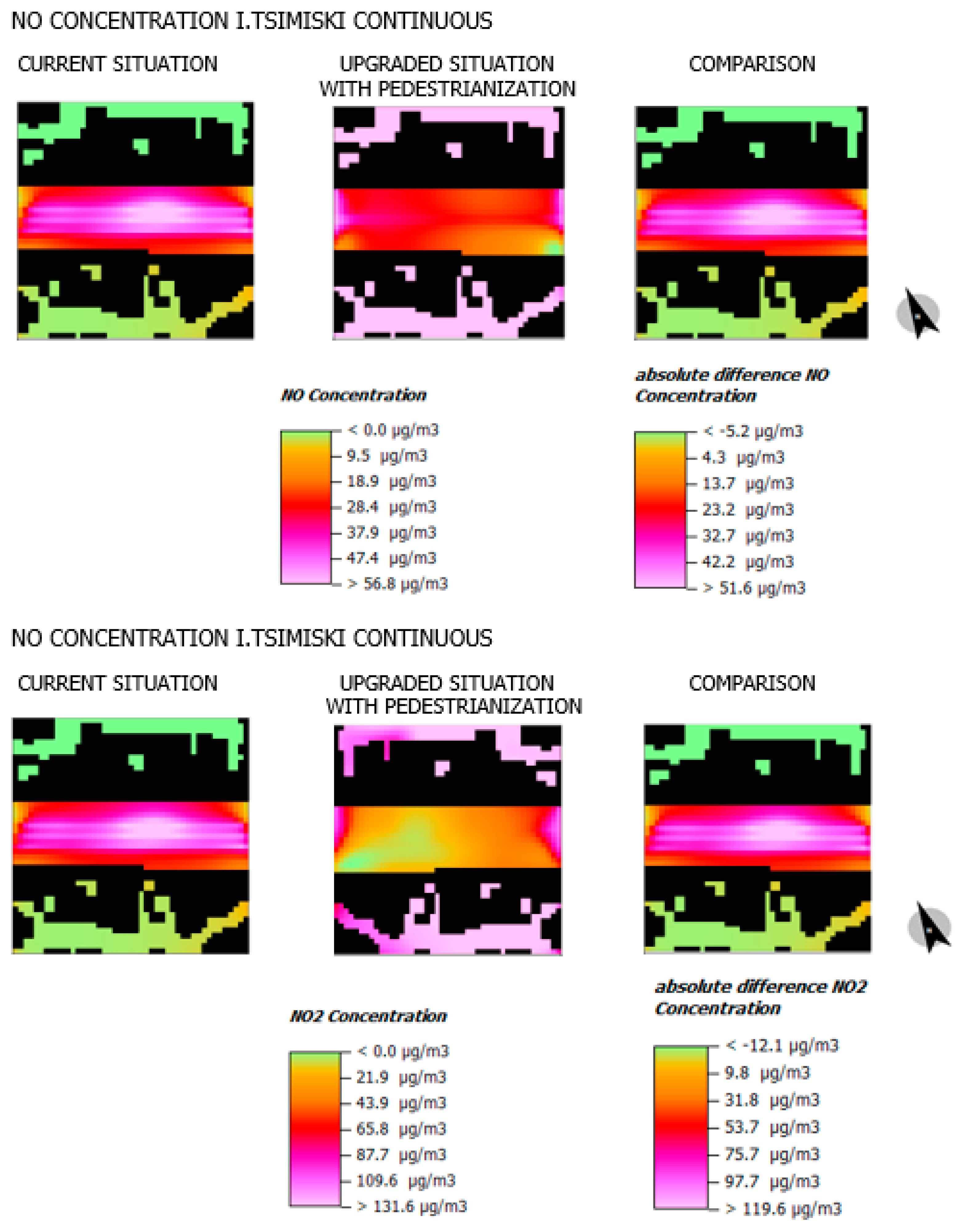
  • Conditions of significant heat stress still prevailed within Tsimiski Street, even in the “radical” scenario (Figure 9). However, the improvement was more noticeable in both median and maximum heat sensations. The additional improvement could make short outdoor stays and walks more viable and reduce heat-related health risks;
  • While the “conservative” scenario failed to effectively lower the ambient air temperature, the “radical” scenario managed an average reduction of 1 °C (Figure 1). This finding could have city-wide implications as the city is able to cool itself more effectively, although this can only be confirmed by future studies through large-scale numerical modeling;
  • The decrease in surface temperatures was significantly greater in the “radical scenario.” Urban surface temperatures reached a median of 27.4 °C (47% reduction from the initial 40.4 °C), which means that they absorb far less heat to be re-emitted after the sun sets (Figure 10);
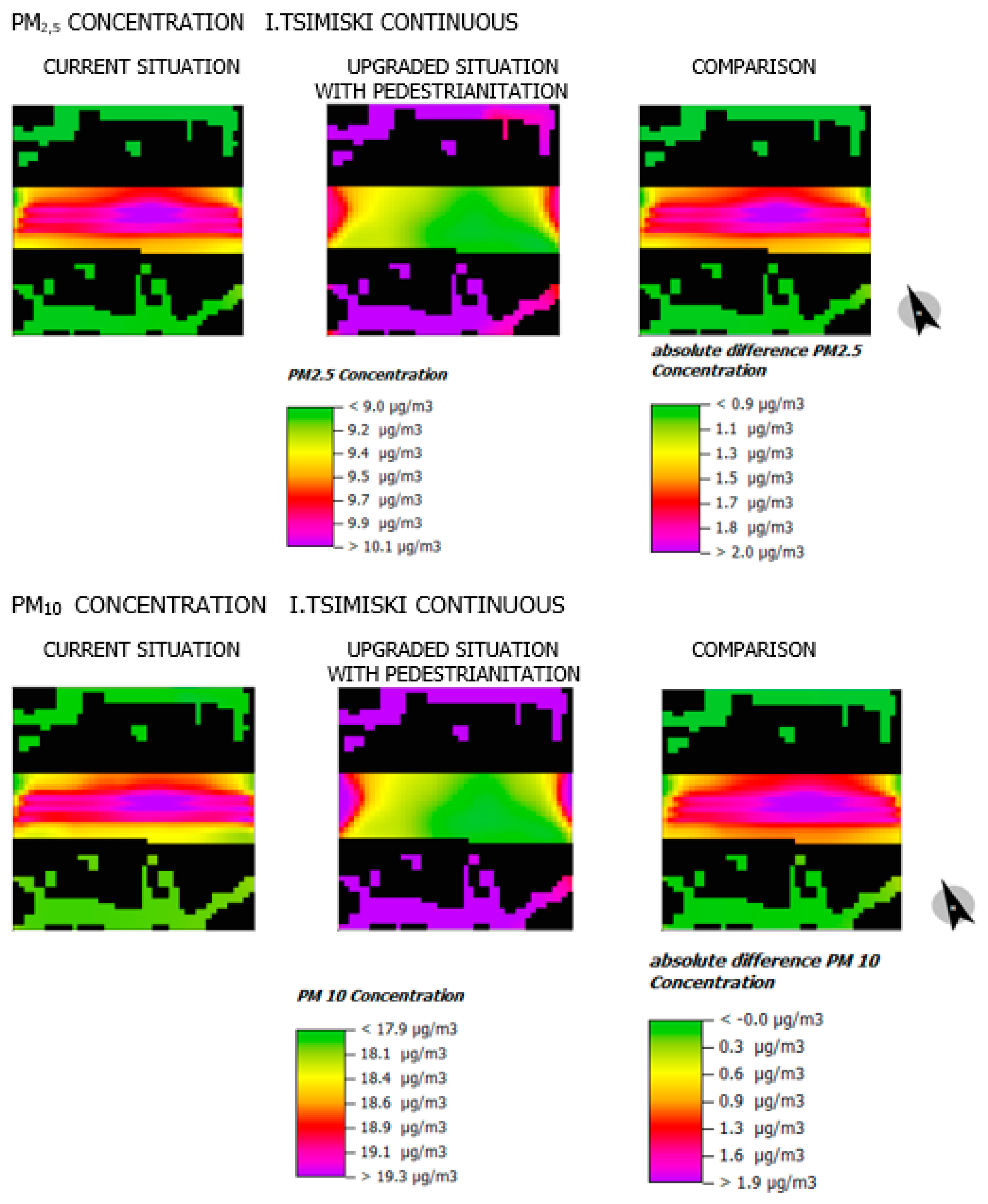
  • Pedestrianization, as expected, nearly nullified local air pollution sources, particularly NOx (Figure 11), while lesser reductions were observed for PM2.5 and PM10 (Figure 12) since they were in small concentrations even in the base case. The remaining levels of air pollution were attributed to background pollution as recorded by the local station and inputted into the simulation software.

4. Discussion and Conclusions

The main objective of this research is the development of urban resilience and environmental planning strategies, with the aim of dealing with the urban heat island effect and reducing the energy footprint of the road network of a Mediterranean city. In this context, the microclimate, the air and surface temperatures, the thermal comfort, as well as the air quality in urban areas around streets in the historical center of Thessaloniki, with different functional hierarchy, geometry, land uses, and traffic volumes, were simulated. In addition, a pilot scenario of conservative environmental upgrading was simulated in the study areas, which included street tree plantings, green roofs, and the replacement of street pavements with environmentally friendly materials. Furthermore, a pilot scenario of pedestrianization of the city center’s main arterial (Tsimiski Street) and the creation of a car-free area was examined. This radical environmental upgrading scenario comprises additional tree plantings to maximize natural shading, the use of cold photocatalytic materials to maximize the solar reflection on-street pavements, as well as the replacement of asphalt with porous materials and plant beds to maximize the absorption of rainwater. The partial environmental upgrading scenario may have reduced the energy footprint annually since the use of active cooling measures is avoided (e.g., outdoor fans and water curtain pumps) with the use of deciduous trees which cooled the street and the adjacent buildings (reducing the consumption of air conditioners) in the warm months, and maintained the solar thermal gain in the cold months. In the total pedestrianization scenario, the energy footprint reduction may have been much greater due to the traffic prohibition and the maximization of natural shading and cooling simultaneously. The environmental simulations were performed for the warmest day of the period 2012–2022, which was August 3rd, 2021, and the results concern the hottest daytime, which was at 16:00, when the maximum air temperature of 41 °C was recorded.
The results showed that a middle-aged person is subject to extreme heat stress when he is exposed to the sun, which is the case with pedestrian crosses. The heat burden is significant even under shade in the existing situation, but the improvement is considerable when environmental urban design measures are applied. The maximum PET thermal comfort index was decreased by 15.6 °C in the “radical scenario,” while the maximum air and surface temperature was reduced by 1.6 °C and 15.2 °C, respectively. These findings are also confirmed by previous studies. Cool materials have been found to reduce the surface temperature of the asphalt pavement by up to 15 °C [26,35,36,37] and the air temperature from 0.2 °C to 3 °C, depending on the albedo increase and the spatial configuration of the study area [38]. Tree shading contributed to a significant reduction in surface temperature by 7 °C to 15 °C on sun-sheltered pavements [26]. Shading is the most efficient strategy to improve thermal comfort [15,19]. However, this is not feasible in all urban areas and streets. In this case, the research findings demonstrated that the car-free interventions combined with the use of environmentally friendly materials in the public realm (e.g., cool, photocatalytic, and porous), as well as the implementation of vegetation on building envelopes, can significantly reduce the heat island effect. These results support the findings of similar studies on pavement and asphalt evaporative cooling via increased permeability [39,40] and the beneficial effect of combining multiple climate adaptation strategies [41,42].
Air quality is an important parameter to consider in environmental design, as higher tree cover can increase the concentration of air pollutants on urban streets. Therefore, environmental interventions must be accompanied by a framework of calming traffic regulations [43] that mitigate gaseous pollutants in the city. It is noteworthy that following the simulated pedestrianization scenario, the nitrogen oxides were reduced by 87% due to the total traffic prohibition. Nevertheless, the decrease of the fine particles (PM2.5) and the coarse particles (PM10) was only 8.5% and 6.5%, respectively, because they are mainly produced by industries, marine aerosols, dust, fires, fly ash, and households, and not by cars.
The study has reported some clear results but also has certain limitations, such as the absence of field measurements of air temperature, humidity, and wind speed to compare with the software estimations. However, the reliability and validity ENVI-Met software were verified by checking the variation of simulation outputs concerning air temperature at different points of the study areas. The absolute error was found to be within a range of 2 °C for the existing condition scenario in all the examined areas, compared to the maximum temperature of 41 °C recorded at the meteorological station. These variations are mainly due to urban morphology, the density of tree planting in the area, but also to the materials used for the construction of the urban environment. It is noteworthy that Chatzidimitriou [44] conducted an extensive study in Thessaloniki and also found small average daily deviations between measurements and simulation results for air and surface temperatures, especially in cases of microclimate conditions near vegetation. Likewise, Kouklis and Giannakou [18] verified the validity of the model through hourly comparisons of measurements and simulation results in Thessaloniki, using data from the same meteorological station used in this study. Finally, Tsoka, Tsikaloudaki, and Theodosiou [27] reviewed 52 studies verifying the accuracy of ENVI-met, and they reported a mean absolute error between 0.27 °C to 3.67 °C with a median of 1.34 °C.
In this research, the microclimate simulation analysis performed demonstrated the negative impacts of the built environment and road traffic on the temperature rise and the air quality in a compact Mediterranean city. Moreover, the urban design interventions were proven resilient if they implemented nature-based solutions. Dealing with extreme heat in cities requires integrated urban and transport planning and an environmental design strategy to promote sustainable mobility behavior, upgrade the public realm, and reduce the ecological footprint of transportation. Future research could focus on investigating and comparing the environmental effects of the complete vehicular traffic electrification scenario, as well as a shared space scenario, including the introduction of a tramway in an exclusively protected corridor, a traffic lane reserved for electric vehicles, and a protected public space for pedestrians and bicycles. There is also plenty of room for future street microclimate studies to further investigate the impact of different vegetation species since there are indications that certain species (i.e., conifers) might be more efficient in lowering ambient urban temperatures [45]. Finally, the relationship between the subjective thermal comfort sensation and air quality needs further investigation, as it has been indicated by a recent study [46].
This study has provided evidence that any Sustainable Urban Mobility Plan that does not consider the dire implications of a hotter climate on the thermal comfort of the pedestrian and the cyclist, as well as the air quality, could be considered incomplete. Finally, the standardization of environmental interventions following a typology of urban streets based on spatial and functional characteristics could support planners and decision-makers in detecting the best solutions for improving the urban microclimate.

Author Contributions

Conceptualization, A.P. and N.S.; methodology, A.P. and N.S.; formal analysis, N.S.; investigation, N.S.; data curation, N.S.; writing—original draft preparation, N.S., A.V. and A.P.; writing—review and editing, A.P., N.S. and A.V.; visualization, A.V. and N.S.; supervision, A.P. All authors have read and agreed to the published version of the manuscript.

Funding

This research received no external funding.

Institutional Review Board Statement

Not applicable.

Informed Consent Statement

Not applicable.

Data Availability Statement

The data that support the findings of this study are available from the corresponding author upon reasonable request. The data are not publicly available due to intellectual property reasons.

Conflicts of Interest

The authors declare no conflict of interest.

References

  1. Friend, R.; Moench, M. What Is the Purpose of Urban Climate Resilience? Implications for Addressing Poverty and Vulnerability. Urban Clim. 2013, 6, 98–113. [Google Scholar] [CrossRef]
  2. Wu, J.; Wu, T. Ecological Resilience as a Foundation for Urban Design and Sustainability. In Resilience in Ecology and Urban Design; Pickett, S., Cadenasso, M., McGrath, B., Eds.; Springer: Berlin/Heidelberg, Germany, 2013; pp. 211–229. [Google Scholar]
  3. Meerow, S.; Newell, J.P.; Stults, M. Defining Urban Resilience: A Review. Landsc. Urban Plan. 2016, 147, 38–49. [Google Scholar] [CrossRef]
  4. Tyler, S.; Nugraha, E.; Nguyen, H.K.; Van Nguyen, N.; Sari, A.D.; Thinpanga, P.; Tran, T.T.; Verma, S.S. Indicators of Urban Climate Resilience: A Contextual Approach. Environ. Sci. Policy 2016, 66, 420–426. [Google Scholar] [CrossRef]
  5. Khavarian-Garmsir, A.R.; Sharifi, A.; Moradpour, N. Are High-Density Districts More Vulnerable to the COVID-19 Pandemic? Sustain. Cities Soc. 2021, 70, 102911. [Google Scholar] [CrossRef]
  6. Tirado-Herrero, S. Measuring Energy Poverty at the Urban Scale: A Barcelona Case Study. In Energy Poverty Alleviation; Springer International Publishing: Cham, Switzerland, 2022; pp. 267–284. [Google Scholar]
  7. Tyler, S.; Moench, M. A Framework for Urban Climate Resilience. Clim. Dev. 2012, 4, 311–326. [Google Scholar] [CrossRef]
  8. Gregg, K. Victor Gruen versus Jan Gehl—And the Contemporary Model of Pedestrianization. J. Urban Des. 2022, 27, 1–18. [Google Scholar] [CrossRef]
  9. Huang, J.; Cui, Y.; Chang, H.; Obracht-Prondzyńska, H.; Kamrowska-Zaluska, D.; Li, L. A City Is Not a Tree: A Multi-City Study on Street Network and Urban Life. Landsc. Urban Plan. 2022, 226, 104469. [Google Scholar] [CrossRef]
  10. Almahmood, M.; Gulsrud, N.M.; Schulze, O.; Carstensen, T.A.; Jørgensen, G. Human-Centred Public Urban Space: Exploring How the ‘Re-Humanisation’ of Cities as a Universal Concept Has Been Adopted and Is Experienced within the Socio-Cultural Context of Riyadh. Urban Res. Pract. 2022, 15, 1–24. [Google Scholar] [CrossRef]
  11. Santos Nouri, A.; Costa, J.; Santamouris, M.; Matzarakis, A. Approaches to Outdoor Thermal Comfort Thresholds through Public Space Design: A Review. Atmosphere 2018, 9, 108. [Google Scholar] [CrossRef]
  12. Founda, D.; Katavoutas, G.; Pierros, F.; Mihalopoulos, N. The Extreme Heat Wave of Summer 2021 in Athens (Greece): Cumulative Heat and Exposure to Heat Stress. Sustainability 2022, 14, 7766. [Google Scholar] [CrossRef]
  13. Chatzidimitriou, A.; Yannas, S. Microclimate Development in Open Urban Spaces: The Influence of Form and Materials. Energy Build. 2015, 108, 156–174. [Google Scholar] [CrossRef]
  14. Girgis, N.; Elariane, S.; Elrazik, M.A. Evaluation of Heat Exhausts Impacts on Pedestrian Thermal Comfort. Sustain. Cities Soc. 2016, 27, 152–159. [Google Scholar] [CrossRef]
  15. Chatzidimitriou, A.; Yannas, S. Street Canyon Design and Improvement Potential for Urban Open Spaces; the Influence of Canyon Aspect Ratio and Orientation on Microclimate and Outdoor Comfort. Sustain. Cities Soc. 2017, 33, 85–101. [Google Scholar] [CrossRef]
  16. Vassiliades, C.; Savvides, A.; Buonomano, A. Building Integration of Active Solar Energy Systems for Façades Renovation in the Urban Fabric: Effects on the Thermal Comfort in Outdoor Public Spaces in Naples and Thessaloniki. Renew. Energy 2022, 190, 30–47. [Google Scholar] [CrossRef]
  17. Tseliou, A.; Tsiros, I.X. Modeling Urban Microclimate to Ameliorate Thermal Sensation Conditions in Outdoor Areas in Athens (Greece). Build. Simul. 2016, 9, 251–267. [Google Scholar] [CrossRef]
  18. Kouklis, G.-R.; Yiannakou, A. The Contribution of Urban Morphology to the Formation of the Microclimate in Compact Urban Cores: A Study in the City Center of Thessaloniki. Urban Sci. 2021, 5, 37. [Google Scholar] [CrossRef]
  19. Vartholomaios, A.; Kalogirou, N. Optimisation of Outdoor Shading Devices with Thermal Comfort Criteria: The Case of the Venetian Port of Chania. IOP Conf. Ser. Earth Environ. Sci. 2020, 410, 012058. [Google Scholar] [CrossRef]
  20. Shashua-Bar, L.; Tsiros, I.X.; Hoffman, M.E. A Modeling Study for Evaluating Passive Cooling Scenarios in Urban Streets with Trees. Case Study: Athens, Greece. Build. Environ. 2010, 45, 2798–2807. [Google Scholar] [CrossRef]
  21. Krüger, E.L.; Minella, F.O.; Rasia, F. Impact of Urban Geometry on Outdoor Thermal Comfort and Air Quality from Field Measurements in Curitiba, Brazil. Build. Environ. 2011, 46, 621–634. [Google Scholar] [CrossRef]
  22. Schaefer, M.; Ebrahimi Salari, H.; Köckler, H.; Thinh, N.X. Assessing Local Heat Stress and Air Quality with the Use of Remote Sensing and Pedestrian Perception in Urban Microclimate Simulations. Sci. Total Environ. 2021, 794, 148709. [Google Scholar] [CrossRef]
  23. Chatzidimitriou, A.; Yannas, S. Microclimatic Studies of Urban Open Spaces in Northern Greece. In Proceedings of the 21st Conference on Passive and Low Energy Architecture, Eindhoven, The Netherlands, 19–22 September 2004; pp. 19–22. [Google Scholar]
  24. Elnabawi, M.H.; Hamza, N.; Dudek, S. Thermal Perception of Outdoor Urban Spaces in the Hot Arid Region of Cairo, Egypt. Sustain. Cities Soc. 2016, 22, 136–145. [Google Scholar] [CrossRef]
  25. Fahed, J.; Kinab, E.; Ginestet, S.; Adolphe, L. Impact of Urban Heat Island Mitigation Measures on Microclimate and Pedestrian Comfort in a Dense Urban District of Lebanon. Sustain. Cities Soc. 2020, 61, 102375. [Google Scholar] [CrossRef]
  26. Tsoka, S.; Tsikaloudaki, K.; Theodosiou, T. Urban Space’s Morphology and Microclimatic Analysis: A Study for a Typical Urban District in the Mediterranean City of Thessaloniki, Greece. Energy Build. 2017, 156, 96–108. [Google Scholar] [CrossRef]
  27. Tsoka, S.; Tsikaloudaki, A.; Theodosiou, T. Analyzing the ENVI-Met Microclimate Model’s Performance and Assessing Cool Materials and Urban Vegetation Applications—A Review. Sustain. Cities Soc. 2018, 43, 55–76. [Google Scholar] [CrossRef]
  28. Zheng, Y.; Ren, C.; Wang, R.; Ho, J.; Lau, K. GIS-Based Mapping of Local Climate Zone in the High-Density City of Hong Kong. Urban Clim. 2018, 24, 419–448. [Google Scholar] [CrossRef]
  29. Yu, B.; Liu, H.; Wu, J.; Lin, W.-M. Investigating Impacts of Urban Morphology on Spatio-Temporal Variations of Solar Radiation with Airborne LIDAR Data and a Solar Flux Model: A Case Study of Downtown Houston. Int. J. Remote Sens. 2009, 30, 4359–4385. [Google Scholar] [CrossRef]
  30. Kyriazis, A. Upgrading Potential of the Greek Cities Urban Tissue and the Role of the ‘Active City Blocks Renewal Tool’. Ph.D. Thesis, Aristotle University of Thessaloniki, Thessaloniki, Greece, 2008. [Google Scholar]
  31. Papagiannakis, A.; Vitopoulou, A.; Yiannakou, A. Transit-oriented development in the southern European city of thessaloniki introducing urban railway: Typology and implementation issues. Eur. Plan. Stud. 2021, 29, 117–141. [Google Scholar] [CrossRef]
  32. Tsamtzi, D.; Papagiannakis, A. Reclaiming City Streets for People: Sustainable Urban Mobility Plan for Thessaloniki. In Proceedings of the 1st International Conference on Changing Cities: Spatial, Μorphological, Formal & Socio-Economic Dimensions, Skiathos, Greece, 18–21 June 2013; Grafima Publications: Skiathos, Greece, 2013; pp. 2379–2388. [Google Scholar]
  33. Meade, R.D.; Akerman, A.P.; Notley, S.R.; McGinn, R.; Poirier, P.; Gosselin, P.; Kenny, G.P. Physiological factors characterizing heat-vulnerable older adults: A narrative review. Environ. Int. 2020, 144, 105909. [Google Scholar] [CrossRef]
  34. van Steen, Y.; Ntarladima, A.M.; Grobbee, R.; Karssenberg, D.; Vaartjes, I. Sex differences in mortality after heat waves: Are elderly women at higher risk? Int. Arch. Occup. Environ. Health 2019, 92, 37–48. [Google Scholar] [CrossRef]
  35. Synnefa, A.; Karlessi, T.; Gaitani, N.; Santamouris, M.; Assimakopoulos, D.N.; Papakatsikas, C. Experimental Testing of Cool Colored Thin Layer Asphalt and Estimation of Its Potential to Improve the Urban Microclimate. Build. Environ. 2011, 46, 38–44. [Google Scholar] [CrossRef]
  36. Erell, E.; Pearlmutter, D.; Boneh, D.; Kutiel, P.B. Effect of High-Albedo Materials on Pedestrian Heat Stress in Urban Street Canyons. Urban Clim. 2014, 10, 367–386. [Google Scholar] [CrossRef]
  37. Georgakis, C.; Zoras, S.; Santamouris, M. Studying the Effect of “Cool” Coatings in Street Urban Canyons and Its Potential as a Heat Island Mitigation Technique. Sustain. Cities Soc. 2014, 13, 20–31. [Google Scholar] [CrossRef]
  38. Osmond, P.; Sharifi, E. Guide to Urban Cooling Strategies. Low Carbon Living CRC 2017. Available online: https://www.lowcarbonlivingcrc.com.au/sites/all/files/publications_file_attachments/rp2024_guide_to_urban_cooling_strategies_2017_web.pdf (accessed on 28 January 2023).
  39. Junsong, W.; Qinglin, M.; Kanghao, T.; Lei, Z.; Yu, Z. Experimental investigation on the influence of evaporative cooling of permeable pavements on outdoor thermal environment. Build. Environ. 2018, 140, 184–193. [Google Scholar] [CrossRef]
  40. Tan, K.; Qin, Y.; Wang, J. Evaluation of the properties and carbon sequestration potential of biochar-modified pervious concrete. Constr. Build. Mater. 2022, 314, 125648. [Google Scholar] [CrossRef]
  41. Akbari, H.; Cartalis, C.; Kolokotsa, D.; Muscio, A.; Pisello, A.L.; Rossi, F.; Santamouris, M.; Synnefa, A.; Wong, N.H.; Zinzi, M. Local climate change and urban heat island mitiga-tion techniques—The state of the art. J. Civ. Eng. Manag. 2021, 22, 1–16. [Google Scholar] [CrossRef]
  42. Santamouris, M. Using cool pavements as a mitigation strategy to fight urban heat island—A review of the actual developments. Renew. Sustain. Energy Rev. 2013, 26, 224–240. [Google Scholar] [CrossRef]
  43. Papagiannakis, A.; Vitopoulou, A. An Urban Strategy in Time of Crisis: Mobility Management and Low-Cost Public Space Design. Spatium 2015, 1, 1–7. [Google Scholar] [CrossRef]
  44. Chatzidimitriou, A.; Liveris, P.; Bruse, M.; Topli, L. Urban Redevelopment and Microclimate Improvement: A Design Project in Thessaloniki, Greece. In Proceedings of the PLEA 2013: Sustainable Architecture for a Renewable Future, Munich, Germany, 10–12 September 2013. [Google Scholar]
  45. Eyster, H.; Beckage, B. Conifers May Ameliorate Urban Heat Waves Better Than Broadleaf Trees: Evidence from Vancouver, Canada. Atmosphere 2022, 13, 830. [Google Scholar] [CrossRef]
  46. Chunping, M.; Xingyuan, H.; Zuo, G.; Wei, C.; Bao-Jie, H. Assessing the vertical synergies between outdoor thermal comfort and air quality in an urban street canyon based on field measurements. Build. Environ. 2023, 227, 109810. [Google Scholar]
Figure 1. Location of the six case study areas within Thessaloniki’s urban fabric.
Land 12 00414 g001
Figure 2. A 3D visualization of the existing and simple improved state of simulated study areas. Light green corresponds to grass and low-lying vegetation, while dark green to tall vegetation.
Land 12 00414 g002
Figure 3. Plan of materials and plantings and 3D visualization of the radical intervention scenario applied to Tsimiski St. continuous segments.
Land 12 00414 g003
Figure 4. Visualization of PET thermal comfort sensation distribution plot at 16:00.
Land 12 00414 g004
Figure 5. Visualization of air temperature distribution at 16:00.
Land 12 00414 g005
Figure 6. Visualization of the distribution of surface temperatures at 16:00.
Land 12 00414 g006
Figure 7. Visualization of nitrogen oxides (NOx) distribution at 16:00.
Land 12 00414 g007
Figure 8. Visualization of the distribution of PM2.5 particulate matter at 16:00.
Land 12 00414 g008
Figure 9. Visualization of PET thermal comfort sensation distribution at the height of 1.35 m from the road surface distribution at 16:00.
Land 12 00414 g009
Figure 10. Visualization of air temperature distribution at the height of 1.35 m from the road surface and surface temperature distribution at 16:00.
Land 12 00414 g010
Figure 11. Visualization of the distribution of nitrogen oxides (NO and NO2).
Land 12 00414 g011
Figure 12. Visualization of microparticle distribution (PM 2.5 and PM 10).
Land 12 00414 g012
Table 1. Typological characteristics of street geometries for Tsimiski St. (cases 1 and 4). Orientation abbreviations correspond to cardinal (e.g., N for North, S for South) and intercardinal (e.g., NW for Northwest) directions.
StreetHierarchy
of Streets
H/W
Ratio
Average SVFOrientationGround Floor
Land Uses
Case
I.Tsimiski
(continuous section)
main road artery1.220.44NW-SE89% retail
11% health
1
I. Tsimiski (junction section)main road artery1.220.52NW-SE92% retail
8% health
4
P.P. Germanouminor road artery1.300.73NE-SW71% retail
29% recreation
4
I. Kouskourasecondary road collector1.430.41NE-SW100% retail4
Iktinoulocal pedestrian street2.430.43NW-SE50% retail
35% recreation
15% food and drink
4
Table 2. Typological characteristics of street geometries for Svolou St. (cases 2 and 5).
StreetHierarchy
of Streets
Ratio H/WAverage SVFOrientationGround Floor
Land Uses
Case
A. Svolou
(continuous section)
primary road collectors1.970.42NW-SE88% commercial
12% recreation
2
A.Svolou (junction)primary road collectors1.970.55NW-SE88% commercial
12% recreation
5
P.P. Germanouminor road artery1.300.81NE-SW92% commercial
8% recreation
5
K. Palaiologousecondary road collectors5.420.91N-S100% commercial5
S. Louilocal3.650.87SE-NW100% commercial5
Table 3. Typological characteristics of street geometries for Statrigou Kallari St. (cases 3 and 6).
StreetHierarchy
of Streets
Ratio H/WAverage SVFOrientationGround Floor
Land Uses
Case
Stratigou Kallari (continuous section)local pedestrian
street
1.970.51SW-NE92% commercial
8% food and drink
3
Stratigou Kallari (juction)local pedestrian
street
1.490.49SW-NE
92% commercial
8% food and drink
6
L. Nikismain road
artery
1.510.94NW-SE74% recreation
26% food and drink
6
MarkentaouSecondary Road
collectors
1.430.41NE-SW100% commercial6
Lori Margaritilocal5.430.91NW-SE50% commercial
50% recreation
6
Table 4. Standardized input data for 3 August 2021, at 16:00.
VariableValue
Longitude/latitude 22.56°, 40.37°
Maximum air temperature 41 °C
Minimum air temperature28 °C
Maximum relative humidity60%
Minimum relative humidity16%
Wind speed and direction0.9 m/s, 23° from North (North-Northeastern direction)
Roughness length (urban space)2.0 m
O3 background level44 μg/m3
SO2 background level5 μg/m3
PM10 background level18 μg/m3
ΝO background level23 μg/m3
ΝO2 background level54 μg/m3
PM2. background level9 μg/m3
CO2 background level400 ppm
Road materialUsed asphalt, albedo = 0.2
Pavement materialPavement slab with a concrete base, albedo = 0.3
Roofing materialsReinforced concrete slab with coating, albedo = 0.3
PlantingHigh-density deciduous tree, height 10 m
Shrubby vegetation of moderate density, height 0.5 m.
Grass, height 0.25 m.
Building indoor temperature 26 °C
Daily vehicle traffic
(no. of vehicles)
I. Tsimiski: 42.210, P.P. Germanou:12.640
A. Svolou: 14.530, L. Nikis: 25.270
Categories of passing vehicles
(on all roads)
Light duty vehicles: 3%, Motorcycles: 5%
Bus: 3%, Passenger cars.: 89%
Table 5. Standardized input data for the conservative and radical intervention scenarios.
Variable Value
Road material:Reflective asphalt albedo = 0.35
Pavement material:Cool/photocatalytic materials with a concrete base, albedo = 0.8
Roofing materials:Reinforced concrete slab with coating, albedo = 0.3
Planting:High-density deciduous tree, height = 15 m
Shrubby vegetation of moderate density, height = 0.5 m.
Herbaceous vegetation, height = 0.25 m.
Planted roofs Deep soil 15 cm in a drainage membrane and waterproofing.
Herbaceous vegetation of medium density, height = 0.5 m.
Grass, height = 0.25 m.
Table 6. Comparison of median values of simulation results for Tsimiski continuous street segment, 3 August 2021, at 16:00.
Existing
Condition
“Conservative” ScenarioRelative Change“Radical” ScenarioRelative Change
Thermal comfort sensation39.5 °C38.1 °C−4%36.7 °C−8%
Air temperature38.2 °C38.1 °C0%37.1 °C−3%
Surface temperature40.4 °C34.0 °C−16%27.4 °C−47%
NO38.2 μg/m336.8 μg/m3−4%5.2 μg/m3−635%
NO288.0 μg/m385.0 μg/m3−3%11.9 μg/m3−639%
PM2.58.7 μg/m38.7 μg/m30%8.0 μg/m3−9%
ΡM1.018.8 μg/m318.8 μg/m30%17.6 μg/m3−7%
Table 7. Comparison of maximum values of simulation results for Tsimiski continuous street segment, August 3rd, 2021, at 16:00.
Existing Condition“Conservative” ScenarioRelative Change“Radical” ScenarioRelative Change
Thermal comfort sensation55.7 °C51.7 °C−7%40.1 °C−30%
Air temperature40.1 °C39.9 °C−1%38.5 °C−4%
Surface temperature56.9 °C53.3 °C−7%41.7 °C−29%
NO66.31 μg/m3 52.07 μg/m3−22%5.2 μg/m3−118%
NO2 153.48 μg/m3120.70 μg/m3−22%12.2 μg/m3−117%
PM2.59.3 μg/m39.0 μg/m3−3%8.0 μg/m3−14%
ΡM1.019.59 μg/m319.36 μg/m3−1%18.0 μg/m3−8%
Disclaimer/Publisher’s Note: The statements, opinions and data contained in all publications are solely those of the individual author(s) and contributor(s) and not of MDPI and/or the editor(s). MDPI and/or the editor(s) disclaim responsibility for any injury to people or property resulting from any ideas, methods, instructions or products referred to in the content.

