


The Construction of the Visible and Invisible Boundaries of Microsegregation: A Case Study from Szeged, Hungary


Abstract
:1. Introduction
2. Materials and Methods
3. Research Design
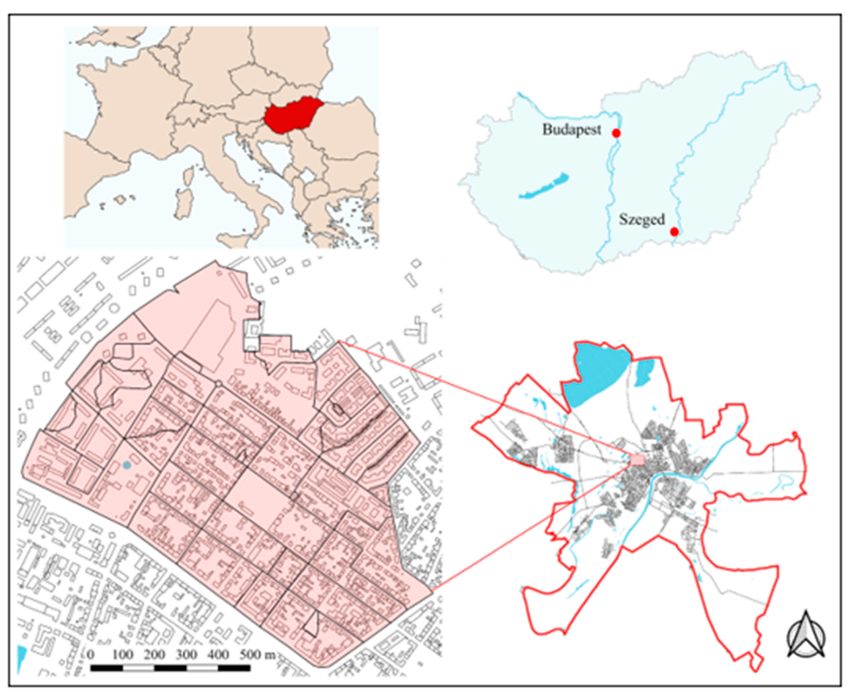
3.1. The Study Area
3.2. Data and Methods
4. Results
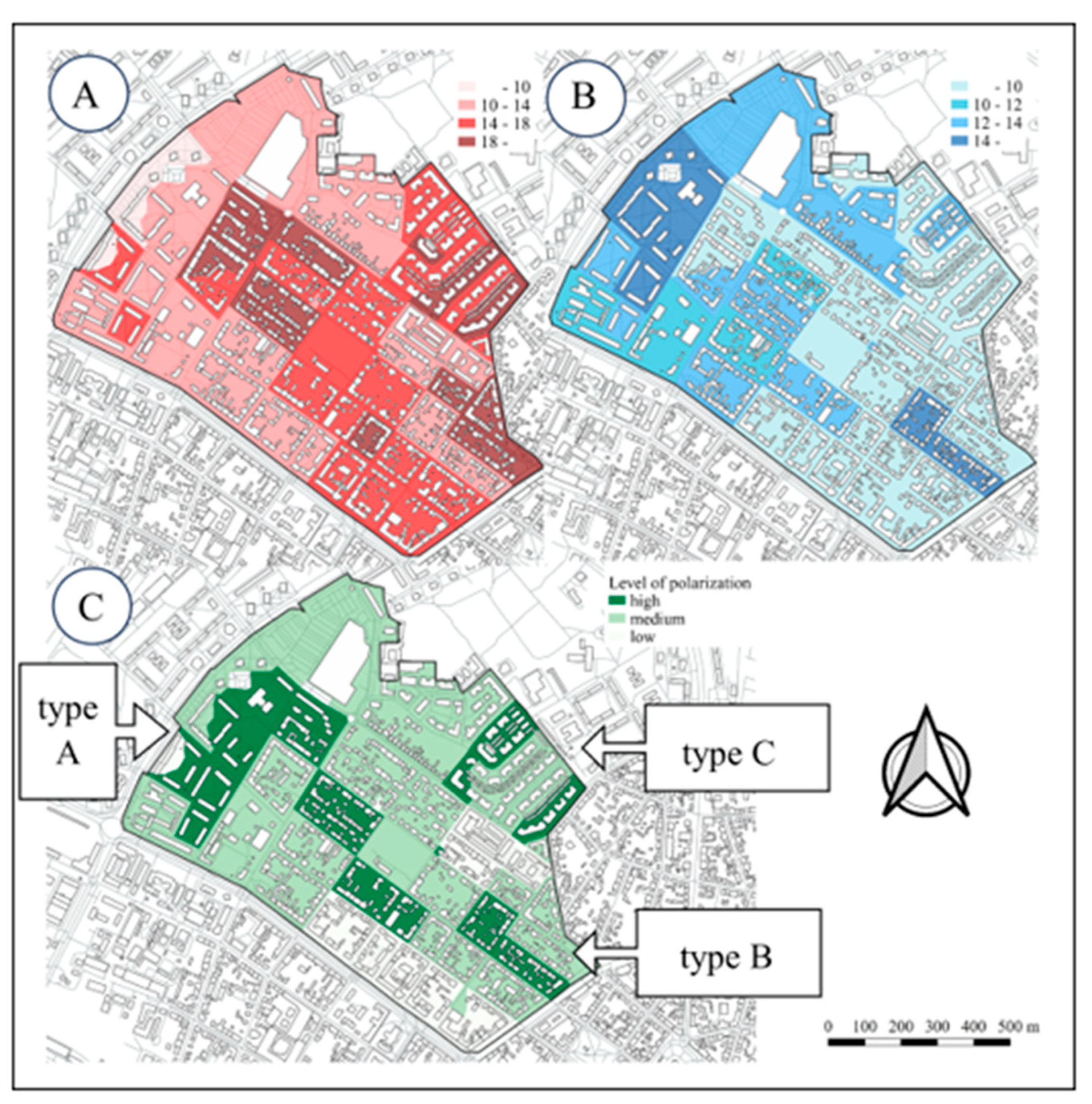
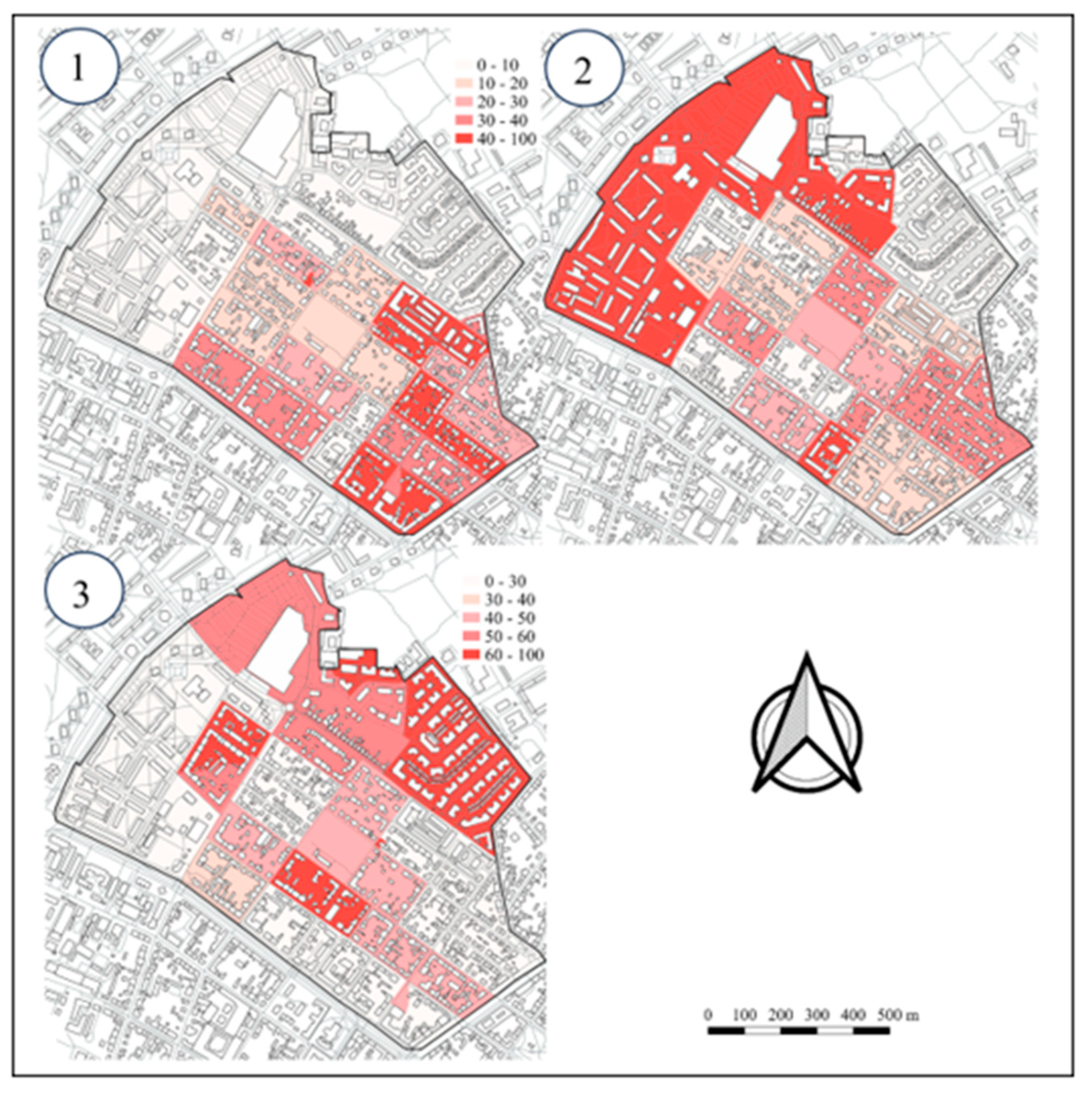
4.1. Quantitative Aspects of Segregation in Rókus
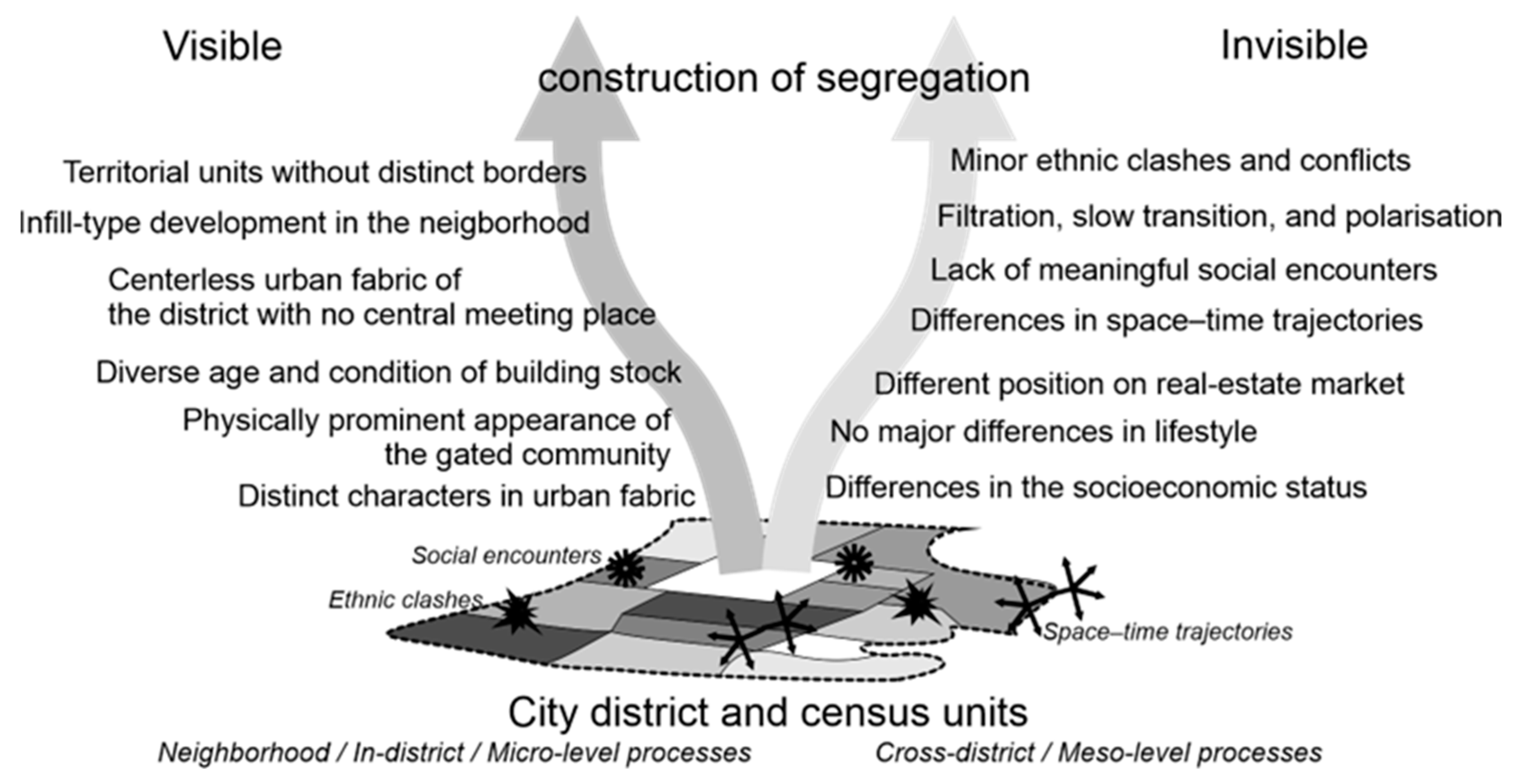
4.2. Qualitative Aspects of Segregation in Rókus
5. Discussion and Conclusions
- 1.
- The concept of segregation at the local level should be redefined. In the study area, segregation processes do not manifest statistically because Hungarian legislation treats segregation as a fundamentally ethnic-based process. This approach should be changed and other factors such as income, educational level, occupation, age, gender, and other factors of segregation should be considered in local planning and policy documents.
- 2.
- Part of the observed microsegregation processes in the neighborhood can be attributed to the lack of social connections and encounters. To change this situation, communal spaces within the neighborhood that provide encounters and places for interactions between diverse socio-economic groups should be developed. In addition, community programs and cultural events organized within the neighborhood could facilitate interactions and coexistence between various societal groups and enhance social cohesion. Involving local communities in decision-making processes and dialogue can also contribute to collaboration and understanding between different groups.
- 3.
- A further challenging issue in the neighborhood under study is the resurgence of lifestyle- and wealth-based segregation processes in educational institutions. Initiatives such as awareness campaigns and educational programs emphasizing social equality could help reduce prejudices and promote acceptance among young people.
Author Contributions
Funding
Conflicts of Interest
References
- Sibley, D. Chicago School. In International Encyclopedia of Human Geography; Kitchin, R., Thrift, T., Eds.; Elsevier: Oxford, UK, 2009; Volume 2, pp. 40–44. [Google Scholar]
- Burgess, E.W. The Growth of the City: An Introduction to a Research Project. Proc. Am. Sociol. Soc. 1923, 18, 57–85. [Google Scholar]
- Musterd, S. (Ed.) Urban Segregation: Contexts, Domains, Dimensions and Approaches. In Handbook of Urban Segregation; Edward Elgar Publishing: Cheltenham, UK, 2020; pp. 2–17. ISBN 9781788115599. [Google Scholar]
- Musterd, S. (Ed.) Towards Further Understanding of Urban Segregation. In Handbook of Urban Segregation; Edward Elgar Publishing: Cheltenham, UK, 2020; pp. 411–424. ISBN 9781788115599. [Google Scholar]
- Andersson, R.; Atkinson, R.; Bailey, N.; Boterman, W.R.; Brama, A.; Cardoso, A.; Cucca, R.; Forrest, R.; Franca, D.; Gou, F.; et al. Handbook of Urban Segregation; Musterd, S., Ed.; Edward Elgar Publishing: Cheltenham, UK, 2020; ISBN 9781788115599. [Google Scholar]
- Tammaru, T.; Marcińczak, S.; Kukk, K. Social Transformations, Housing and Socio-Economic Segregation in the Fast-Track Reform Countries. In The Routledge International Handbook of European Social Transformations; Vihalemm, P., Masso, A., Operman, S., Eds.; Routledge: London, UK, 2017; pp. 159–171. ISBN 9781472477941. [Google Scholar]
- Arefia, F.F.; Batty, M.; Davoudi, S.; DeVerteuil, G.; Kirby, A.; Kropf, K.; Lucas, K.; Maretto, M.; Neuhaus, F.; Nijhuis, S.; et al. Urban Socio-Economic Segregation and Income Inequality; van Ham, M., Tammaru, T., Ubareviciene, R., Janssen, H., Eds.; Springer Nature Switzerland AG: Cham, Switzerland, 2021; ISBN 9783030645687. [Google Scholar]
- Marcińczak, S.; Musterd, S.; Van Ham, M.; Tammaru, T. Inequality and Rising Levels of Socio-Economic Segregation: Lessons from a Pan-European Comparative Study. In Socio-Economic Segregation in European Capital Cities: East Meets West; Tammaru, Y., Marcińczak, S., van Ham, M., Musterd, S., Eds.; Routledge: London, UK, 2015; pp. 358–382. ISBN 978-131763747-9. [Google Scholar]
- Marcińczak, S.; Gentile, M.; Stępniak, M. Paradoxes of (Post)Socialist Segregation: Metropolitan Sociospatial Divisions Under Socialism and After In Poland. Urban Geogr. 2013, 34, 327–352. [Google Scholar] [CrossRef]
- Kovács, Z. Do Market Forces Reduce Segregation? The Controversies of Post-Socialist Urban Regions of Central and Eastern Europe. In Handbook of Urban Segregation; Musterd, S., Ed.; Edward Elgar Publishing: Cheltenham, UK, 2020; pp. 118–133. ISBN 9781788115599. [Google Scholar]
- Maloutas, T.; Karadimitriou, N. (Eds.) Introduction to Vertical Cities: Urban Micro-Segregation, Housing Markets and Social Reproduction. In Vertical Cities; Edward Elgar Publishing: Cheltenham, UK, 2022; pp. 1–21. ISBN 9781800886384. [Google Scholar]
- Ashery, S.F. Micro-Residential Dynamics: A Case Study of Whitechapel, London; Springer: London, UK, 2019; ISBN 9783030006013. [Google Scholar]
- Hopkins, P. Social Geography I: Intersectionality. Prog. Hum. Geogr. 2019, 43, 937–947. [Google Scholar] [CrossRef]
- Hopkins, P. Households, Families, and Structural Inequalities: Reflections on “How the Other Half Lives”. Area 2020, 52, 806–811. [Google Scholar] [CrossRef]
- Simandan, D. Revisiting Positionality and the Thesis of Situated Knowledge. Dialogues Hum. Geogr. 2019, 9, 129–149. [Google Scholar] [CrossRef]
- Dines, N.; Mattiucci, C. Constantly Evoked but Under-Researched: The Conundrum of Vertical Stratification in Naples. In Vertical Cities; Maloutas, T., Karadimitriou, N., Eds.; Edward Elgar Publishing: Cheltenham, UK, 2022; pp. 23–38. ISBN 9781800886384. [Google Scholar]
- Maloutas, T.; Spyrellis, S.N. Vertical Segregation: Mapping the Vertical Social Stratification of Residents in Athenian Apartment Buildings. J. Mediterr. Geogr. 2016, 127, 27–36. [Google Scholar] [CrossRef]
- Dimitrakou, I.; Balampanidis, D.; Myofa, N.; Polyzou, I.; Siatitsa, D.; Spyrellis, S.; Vakalopoulos, K. Micro-Segregation and Coexistence in Athens: The Debate on Segregation and Its Implications for Urban Research. In Vertical Cities; Maloutas, T., Karadimitriou, N., Eds.; Edward Elgar Publishing: Cheltenham, UK, 2022; pp. 73–87. ISBN 9781800886391. [Google Scholar]
- Lin, S.; Li, Z. Vertical Segregation of Rural Migrants in Urban China: A Case Study of Beijing, Shanghai, and Guangzhou. In Vertical Cities; Maloutas, T., Karadimitriou, N., Eds.; Edward Elgar Publishing: Cheltenham, UK, 2022; pp. 139–153. ISBN 9781800886384. [Google Scholar]
- Shamur, T.; Yacobi, H. Compulsory Social Mix, Micro-Scale Segregation and Gentrification: The Case of Gan HaHashmal Neighbourhood, Tel Aviv. In Vertical Cities; Maloutas, T., Karadimitriou, N., Eds.; Edward Elgar Publishing: Cheltenham, UK, 2022; pp. 253–269. ISBN 9781800886384. [Google Scholar]
- Leontidou, L. The Mediterranean City in Transition; Cambridge University Press: Cambridge, UK, 1990. [Google Scholar] [CrossRef]
- Maloutas, T.; Karadimitriou, N. Vertical Social Differentiation in Athens: Alternative or Complement to Community Segregation? Int. J. Urban Reg. Res. 2001, 25, 699–716. [Google Scholar] [CrossRef]
- Marcińczak, S.; Hess, D.B. Vertical Segregation of Apartment Building Dwellers during Late State Socialism in Bucharest, Romania. Urban Geogr. 2020, 41, 823–848. [Google Scholar] [CrossRef]
- Meyer, A.; Pfirsch, T. Flat by Flat: Producing Micro-Scale Social Differentiation in an Arrival Neighbourhood of Marseille. In Vertical Cities; Maloutas, T., Karadimitriou, N., Eds.; Edward Elgar Publishing: Cheltenham, UK, 2022; pp. 39–56. ISBN 9781800886384. [Google Scholar]
- van Gent, W.; Hochstenbach, C. The Impact of Gentrification on Social and Ethnic Segregation. In Handbook of Urban Segregation; Musterd, S., Ed.; Edward Elgar Publishing: Cheltenham, UK, 2020; pp. 306–324. ISBN 9781788115599. [Google Scholar]
- Leetmaa, K.; Suitso, E.M.; Kalm, K.; Pastak, I.; Tammaru, T. Gentrification as a Micro-Segregation Phenomenon: Social and Spatial Layers of Tallinn Inner City. In Vertical Cities; Maloutas, T., Karadimitriou, N., Eds.; Edward Elgar Publishing: Cheltenham, UK, 2022; pp. 219–236. ISBN 9781800886384. [Google Scholar]
- Kubeš, J.; Kovács, Z. The Kaleidoscope of Gentrification in Post-Socialist Cities. Urban Stud. 2020, 57, 2591–2611. [Google Scholar] [CrossRef]
- Simandan, D. Being Surprised and Surprising Ourselves: A Geography of Personal and Social Change. Prog. Hum. Geogr. 2020, 44, 99–118. [Google Scholar] [CrossRef]
- Burdick-Will, J. School Location, Social Ties, and Perceived Neighborhood Boundaries. City Community 2018, 17, 418–437. [Google Scholar] [CrossRef]
- Burdick-Will, J.; Grigg, J.A.; Nerenberg, K.M.; Connolly, F. Socially-Structured Mobility Networks and School Segregation Dynamics: The Role of Emergent Consideration Sets. Am. Sociol. Rev. 2020, 85, 675–708. [Google Scholar] [CrossRef]
- Logan, J.R.; Burdick-Will, J. School Segregation, Charter Schools, and Access To Quality Education. J. Urban Aff. 2016, 38, 323–343. [Google Scholar] [CrossRef] [PubMed]
- Logan, J.R.; Minca, E.; Adar, S. The Geography of Inequality: Why Separate Means Unequal in American Public Schools. Sociol. Educ. 2012, 85, 287–301. [Google Scholar] [CrossRef] [PubMed]
- Logan, J.R.; Burdick-Will, J. School Segregation and Disparities in Urban, Suburban, and Rural Areas. Ann. Am. Acad. Political Soc. Sci. 2017, 674, 199–216. [Google Scholar] [CrossRef] [PubMed]
- Ho, H.K.; Yip, M. From Micro- to Nano-Segregation: Policy-Led Vertical Urbanism in Hong Kong. Int. J. Hous. Policy 2023, 1–15. [Google Scholar] [CrossRef]
- Drozdzewski, D.; Webster, N.A. (Re)Visiting the Neighbourhood. Geogr. Compass 2021, 15, e12597. [Google Scholar] [CrossRef]
- Andersson, R.; Musterd, S. What Scale Matters? Exploring the Relationships between Individuals’ Social Position, Neighbourhood Context and the Scale of Neighbourhood. Geogr. Ann. Ser. B 2010, 92, 23–43. [Google Scholar] [CrossRef]
- Forrest, R.; Tong, K.S.; Wang, W. Residential Stratification and Segmentation in the Hyper-Vertical City. In Handbook of Urban Segregation; Musterd, S., Ed.; Edward Elgar Publishing: Cheltenham, UK, 2020; pp. 346–365. [Google Scholar]
- Maloutas, T. Vertical Social Differentiation as Segregation in Spatial Proximity. In Handbook of Urban Segregation; Musterd, S., Ed.; Edward Elgar Publishing: Cheltenham, UK, 2020; pp. 325–345. ISBN 9781788115599. [Google Scholar]
- Kovács, Z. Residential Segregation in Budapest before and after Transition. In Residential Segregation in Comparative Perspective; Maloutas, T., Fujita, K., Eds.; Routledge: London, UK, 2012; pp. 197–216. ISBN 9781409418733. [Google Scholar]
- Boros, L.; Fabula, S.; Horváth, D.; Kovács, Z. Urban Diversity and the Production of Public Space in Budapest. Hung. Geogr. Bull. 2016, 65, 209–224. [Google Scholar] [CrossRef]
- Creţan, R.; Málovics, G.; Berki, B.M. On the Perpetuation and Contestation of Racial Stigma: Urban Roma in a Disadvantaged Neighbourhood of Szeged. Geogr. Pannonica 2020, 24, 294–310. [Google Scholar] [CrossRef]
- Fabula, S.; Boros, L.; Kovács, Z.; Horváth, D.; Pál, V. Studentification, Diversity and Social Cohesion in Post-Socialist Budapest. Hung. Geogr. Bull. 2017, 66, 157–173. [Google Scholar] [CrossRef]
- Ladányi, J. Residential Segregation among Social and Ethnic Groups in Budapest during the Post-Communist Transition. In Of States and Cities; Marcuse, P., Van Kempen, R., Eds.; Oxford University Press: Oxford, UK, 2002; pp. 170–182. ISBN 9780198297192. [Google Scholar]
- Kovács, Z.; Székely, J.; Szabó, B. Vertical Micro-Segregation in Apartment Buildings in Budapest. In Vertical Cities; Maloutas, T., Karadimitriou, N., Eds.; Edward Elgar Publishing: Cheltenham, UK, 2022; pp. 189–203. ISBN 9781800886384. [Google Scholar]
- Maloutas, T.; Spyrellis, S.N.; Szabó, B.; Kovács, Z. Vertical Segregation in the Apartment Blocks of Athens and Budapest: A Comparative Study. Eur. Urban Reg. Stud. 2023, 30, 72–90. [Google Scholar] [CrossRef]
- Marcińczak, S.; Hess, D.B. Vertical Separation in High-Rise Apartment Buildings: Evidence from Bucharest and Budapest under State Socialism. In Vertical Cities; Maloutas, T., Karadimitriou, N., Eds.; Edward Elgar Publishing: Cheltenham, UK, 2022; pp. 173–188. ISBN 9781800886384. [Google Scholar]
- Marcińczak, S.; Gentile, M. A Window Into the European City: Exploring Socioeconomic Residential Segregation in Urban Poland. Tijdschr. Voor Econ. Soc. Geogr. 2023, 114, 252–266. [Google Scholar] [CrossRef]
- Pénzes, J.; Demeter, G. Peripheral Areas and Their Distinctive Characteristics: The Case of Hungary. Morav. Geogr. Rep. 2021, 29, 217–230. [Google Scholar] [CrossRef]
- Málovics, G.; Creţan, R.; Méreiné Berki, B.; Tóth, J. Urban Roma, Segregation and Place Attachment in Szeged, Hungary. Area 2019, 51, 72–83. [Google Scholar] [CrossRef]
- Málovics, G.; Creţan, R.; Méreine-Berki, B.; Tóth, J. Socio-Environmental Justice, Participatory Development, and Empowerment of Segregated Urban Roma: Lessons from Szeged, Hungary. Cities 2019, 91, 137–145. [Google Scholar] [CrossRef]
- Méreiné-Berki, B.; Málovics, G.; Creţan, R. “You Become One with the Place”: Social Mixing, Social Capital, and the Lived Experience of Urban Desegregation in the Roma Community. Cities 2021, 117, 103302. [Google Scholar] [CrossRef]
- Bakó, B.; Batiz, A.; Berényi, E.; Bernáth, G.; Ercse, K.; Fejes, J.B.; Horlai, S.; Hricsovinyi, J.; Józsa, K.; Juhász, J.; et al. Én Vétkem: Helyzetkép Az Oktatási Szegregációról; Fejes, J.B., Szűcs, N., Eds.; Motiváció Oktatási Egyesület: Szeged, Hungary, 2018; ISBN 9786150011561. [Google Scholar]
- Tóth, B.; Vida, G.; Lados, G.; Kovács, Z. The Potentials of Cross-Border Tourism Development in the Lower-Tisa Valley. Geoj. Tour. Geosites 2020, 28, 360–375. [Google Scholar] [CrossRef]
- Kolcsár, R.A.; Csete, Á.K.; Kovács-Győri, A.; Szilassi, P. Age-Group-Based Evaluation of Residents’ Urban Green Space Provision: Szeged, Hungary. A Case Study. Hung. Geogr. Bull. 2022, 71, 249–269. [Google Scholar] [CrossRef]
- Egedy, T.; Szabó, B.; Antypenko, H.; Benkő, M. Planning and Architecture as Determining Influences on the Housing Market: Budapest–Csepel’s Post–War Housing Estates. Urban Plan 2022, 7, 325–338. [Google Scholar] [CrossRef]
- Szelényi, I. Urban Inequalities under State Socialism; Oxford University Press: Oxford, UK, 1983; ISBN 9780198771760. [Google Scholar]
- Kovács, Z.; Egedy, T.; Szabó, B. Persistence or Change: Divergent Trajectories of Large Housing Estates in Budapest, Hungary. In Housing Estates in Europe; Hess, D.B., Tammaru, T., van Ham, M., Eds.; Springer Nature Switzerland AG: Cham, Switzerland, 2018; pp. 191–214. ISBN 9783319928128. [Google Scholar]
- Ouředníček, M.; Pospíšilová, L.; Špačková, P.; Kopecká, Z.; Novák, J. The Velvet and Mild: Socio-Spatial Differentiation in Prague after Transition. In Socio-Economic Segregation in European Capital Cities; Tammaru, T., van Ham, M., Marcińczak, S., Musterd, S., Eds.; Routledge: London, UK, 2015; pp. 261–286. ISBN 978-131763747-9. [Google Scholar]
- Kovács, Z.; Hegedűs, G. Gated Communities as New Forms of Segregation in Post-Socialist Budapest. Cities 2014, 36, 200–209. [Google Scholar] [CrossRef]
- Matejskova, T.; Leitner, H. Urban Encounters with Difference: The Contact Hypothesis and Immigrant Integration Projects in Eastern Berlin. Soc. Cult. Geogr. 2011, 12, 717–741. [Google Scholar] [CrossRef]
- Hopkins, P. Social Geography III: Committing to Social Justice. Prog. Hum. Geogr. 2021, 45, 382–393. [Google Scholar] [CrossRef]
- Barnett, C. Geography and the Priority of Injustice. Ann. Am. Assoc. Geogr. 2018, 108, 317–326. [Google Scholar] [CrossRef]


| Szeged | % | Rókus | (%) | |
|---|---|---|---|---|
| Population | 168,048 | 100.00 | 9237 | 100.00 |
| Age group 0–14 years | 21,860 | 13.01 | 1552 | 16.80 |
| Age group 65+ years | 27,258 | 16.22 | 833 | 9.02 |
| Tertiary education | 36,551 | 21.75 | 2242 | 24.27 |
| Active earners | 61,699 | 36.72 | 3917 | 42.41 |
| ISCO1–2 | 20,965 | 12.48 | 1381 | 14.95 |
| ISCO7–9 | 18,247 | 10.86 | 973 | 10.53 |
| Housing | 70,821 | 100.00 | 4018 | 100.00 |
| One-bedroom dwellings | 5988 | 8.46 | 569 | 14.16 |
| Four+−bedroom dwellings | 13,701 | 19.35 | 653 | 16.25 |
| Built before 1946 | 8919 | 12.59 | 487 | 12.12 |
| Built after 1990 | 13,425 | 18.96 | 2043 | 50.85 |
| Low-comfort dwellings | 1876 | 2.65 | 119 | 2.96 |
Disclaimer/Publisher’s Note: The statements, opinions and data contained in all publications are solely those of the individual author(s) and contributor(s) and not of MDPI and/or the editor(s). MDPI and/or the editor(s) disclaim responsibility for any injury to people or property resulting from any ideas, methods, instructions or products referred to in the content. |
© 2023 by the authors. Licensee MDPI, Basel, Switzerland. This article is an open access article distributed under the terms and conditions of the Creative Commons Attribution (CC BY) license (https://creativecommons.org/licenses/by/4.0/).
Share and Cite
Vámos, R.; Nagy, G.; Kovács, Z. The Construction of the Visible and Invisible Boundaries of Microsegregation: A Case Study from Szeged, Hungary. Land 2023, 12, 1835. https://doi.org/10.3390/land12101835
Vámos R, Nagy G, Kovács Z. The Construction of the Visible and Invisible Boundaries of Microsegregation: A Case Study from Szeged, Hungary. Land. 2023; 12(10):1835. https://doi.org/10.3390/land12101835
Chicago/Turabian StyleVámos, Ramóna, Gyula Nagy, and Zoltán Kovács. 2023. "The Construction of the Visible and Invisible Boundaries of Microsegregation: A Case Study from Szeged, Hungary" Land 12, no. 10: 1835. https://doi.org/10.3390/land12101835
APA StyleVámos, R., Nagy, G., & Kovács, Z. (2023). The Construction of the Visible and Invisible Boundaries of Microsegregation: A Case Study from Szeged, Hungary. Land, 12(10), 1835. https://doi.org/10.3390/land12101835