1. Introduction
Under the tide of globalization and localization, rural socio-economic phenomena are increasingly affected by many factors outside the region [
1]. Complex internal and external factors reinvented its basic cultural, economic, political, and social precepts [
2]. In the progress of rural reconstitution under globalization, the interaction between local and global actors, as well as human and non-human actors, has produced new hybrid forms and relations in global countryside [
3]. For some time, China’s rapid industrialization and urbanization process has attracted a large number of rural laborers to cities, and the scale of cities and small- and medium-sized towns has expanded rapidly, leading to great changes in rural economic, social, and settlement spaces [
4,
5]. Rural recession—characterized by people leaving rural areas, unfarmed land, and rural culture homogenization—has gradually become indisputable [
6,
7]. China’s social economy has entered a transition period and the successive implementation of development strategies, as well as social and economic factors such as social capital and political forces have constantly impacted traditional rural spaces. In recent years, China has vigorously promoted the Rural Revitalization Strategy, aiming to realize the modernization of agriculture and common prosperity through the comprehensive development of rural industries, talents, culture, ecology, and organizations. At the same time, the Chinese government officially promulgated the law of the Promoting Rural Revitalization in April 2021, which further improved the legal system and policy measures for rural development. In this context, rural development has faced multidimensional changes, such as the reorganization of population factors and the reconstruction of spatial and cultural factors, as well as the evolution of agricultural policy and social structure [
8,
9,
10]. Notably, the anticipated decrease in traditional farming and the commensurate increase in peri-urban and urban farming will have economic consequences for some rural areas [
11].
In the progress of rural spatial differentiation and reorganization, the quest for an understanding of the function, value, and influence of rural settlements has intensified. With the emergence of empty villages, the continued strengthening of the integration of urban and rural elements, the preliminary achievements in the renovation of rural settlements, and the increase in the demand for construction land by rural industrial developers, the reconstruction of rural settlements has gradually been considered in theoretical and practical research [
12,
13,
14]. At the beginning, the land use policy represented by the linkage between upsurge and decline in the quantity of urban and rural construction land constituted the main focus for rural settlement reconstruction, in which the main purpose was to solve the contradiction between the extensive and inefficient use of rural land and the scarcity of urban construction land in the process of urbanization [
15,
16]. Consequently, to improve efficiency in rural land use, a series of progressive policies—including the development of a new countryside, the beautifying of the countryside, and a new type of urbanization—have been implemented by China’s central government since 2005 [
17,
18]. However, the rural settlement reconstruction policy aimed at alleviating the contradiction between land supply and demand has triggered a series of new development problems, such as the compression of ecological space, the occupation of high-quality cultivated land, and the insufficient protection of farmers’ rights and interests [
19]. Aware of these shortcomings, some scholars and local governments have begun to explore multiobjective rural settlement reconstruction policy, taking into account ecological protection, cultivated land use, agricultural production practices, farmers’ wishes, and other factors [
20,
21,
22]. Overall, rural settlement reconstruction has gradually shifted its focus from the relocation and integration of spatial material entities to the multidimensional reconstruction of rural settlement material space, social space, and economic space, which concern industry, population, and land [
23]. The research scale has gradually focused on the village level, and the research methods have diversified.
As an important type of rural land use, rural settlements have unified material spaces and social spaces. Indeed, these settlements not only constitute the villagers’ living spaces but also spaces for communication, social contact, and production activities [
24,
25,
26]. It is difficult to separate rural settlements from their elements, functions, and various humanistic activities, and it is even more difficult to ignore the impact of people-centered socioeconomic processes on rural settlements [
27]. Therefore, the reconstruction of rural settlements not only has changed how villagers live in those spaces, but it has also constructed a new pattern of social and productive relations [
28]. At the same time, these factors have in turn affected the utilization of rural settlement spaces [
29]. From this perspective, the reconstruction of rural settlement spaces has brought together the reconstruction of rural production spaces, rural living spaces, and rural ecological spaces. However, at present, the spatial reconstruction of rural settlements in China still focuses on the spatial replacement of urban and rural construction land [
30]. Investigations into the demolition of old settlements and the site selection for new settlements have mainly been based on the expanse of rural construction land, ecological suitability, traffic location, and urban construction needs but they have failed to fully consider the differences in villagers’ wishes, livelihoods, and social activities and contacts [
31,
32,
33]. Therefore, although current practices in rural settlement reconstruction in China have saved rural construction land resources, somewhat improved land use efficiency, and solved the villagers’ problems stemming from the harsh environment, the transfer of rural settlements may have damaged the original relations between rural neighborhoods and habitual social practices [
34,
35,
36]. Since farmers’ livelihood activities had not changed when they moved into their new houses, they obviously have had to spend more time traveling to their fields for agricultural production. At the same time, more contradictions have emerged in the use of public space for centralized residential purposes.
Although traditional social relationships have been greatly weakened in our move from an agricultural society to the postindustrial era, geo-relationships and kinships still play key roles in rural society [
37,
38,
39]. Maintaining stable social relationships and conveniently engaging in production activities are not necessary elements for farmers, but they also represent the key to avoiding the intensification of social contradictions in rural areas [
40]. To the best of our knowledge, the question of how to address the interaction between agricultural production, farmers’ daily lives, and rural ecological environments in the spatial reconstruction of rural settlements has not yet been intensely studied. To fill this research gap, we integrated production suitability and living suitability into the question of spatial reconstruction in rural settlements and proposed a multipurpose spatial reconstruction model for those settlements. The optimization objectives, i.e., the ecological suitability of rural settlement layout, convenience in everyday life and production activities, and the various wishes of farmers’ families, were considered in the reconstruction process. This study aimed to answer the following questions: (1) How can production suitability, living suitability, and ecological suitability be combined in rural settlement reconstruction?; (2) What are the differences between the objects of rural settlement demolition and relocation under different suitability types?; and (3) How do farmers’ individual characteristics affect rural settlement reconstruction?
2. Study Area and Data
2.1. Study Area
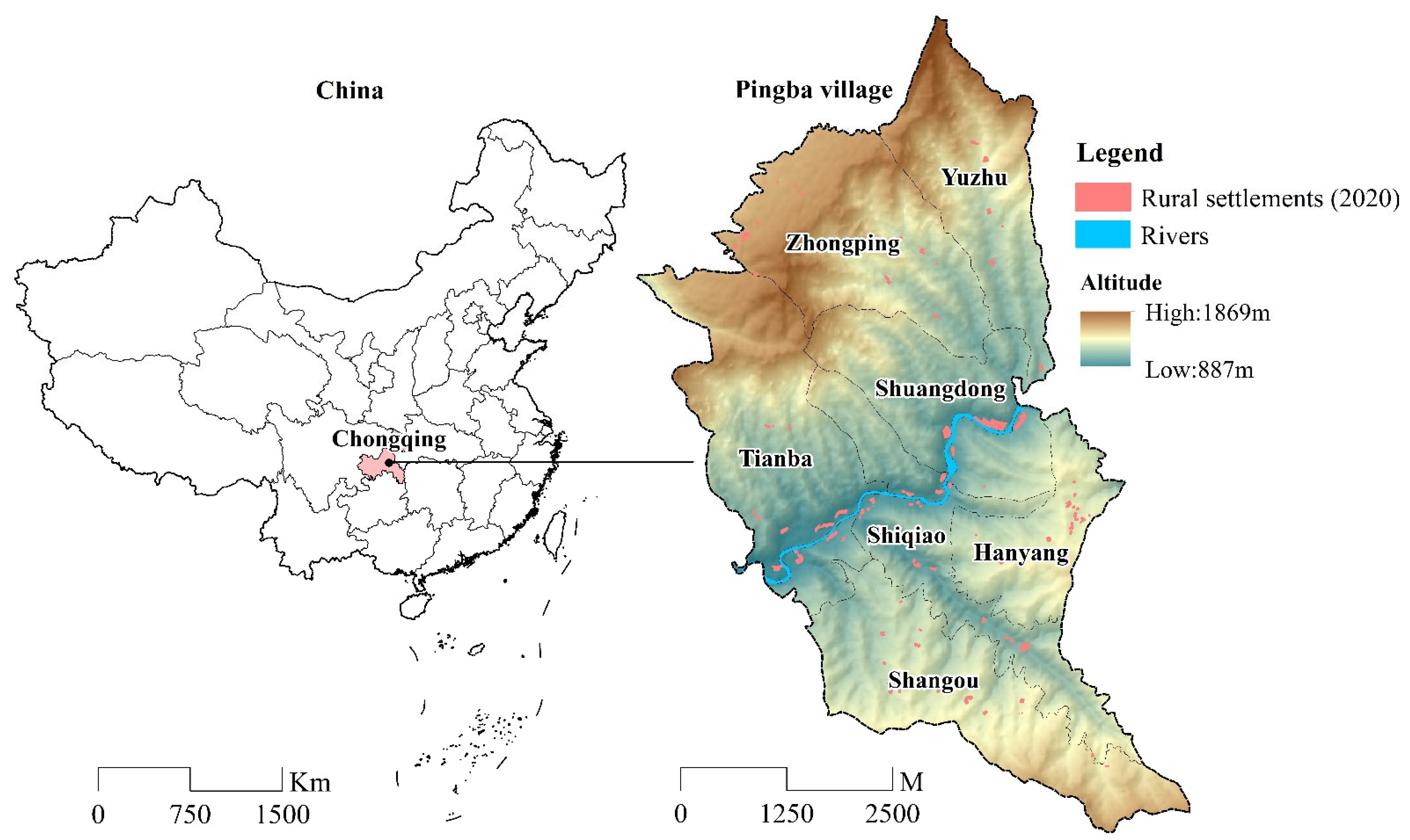
The village of Pingba is located in Zhongyi town, Shizhu County, Chongqing city, in Southwest China. As one of China’s four municipalities directly under the central government, Chongqing has developed rapidly in recent years, attracting a large number of rural laborers from surrounding districts and counties to work in its central urban area. At the same time, the rural areas in the northeast and southeast of the region have faced the double dilemma of population outflow and rural hollowing due to geographical limitations and a socioeconomic development that has been relatively lagging. Pingba is a typical village, covering an area of 29.23 km
2, with a total population of approximately 1400 people living in rural settlements spread over a total area of 17.16 hm
2. Pingba village is located in northeastern Chongqing. Its terrain is dominated by mountains and hills (
Figure 1). It is rich in forest resources and has important water conservation functions. At the same time, its ecological environment is relatively fragile and represents an important ecological protection area. Affected by the terrain, Pingba’s rural settlements are mainly distributed along mountain gullies, showing strips. Moreover, settlements have developed at different scales. There are still many rural settlements scattered on the hillsides where the altitude is higher.
Before 2020, Pingba was one of thousands of poor villages in China. After alleviating poverty there, the local government aimed at promoting rural revitalization by vigorously developing rural tourism and building pilot rural homestays. Some farmers living in favorable locations have begun to engage in the service industry to make a living. However, for many other farmers still living a traditional agricultural life, the main source of livelihood has remained traditional Chinese medicinal plant agriculture. In recent years, the Chongqing municipal government has promoted the implementation of an ecological relocation project for alpine immigrants, which aims to relocate rural settlements established at high altitudes and on steep slopes to low altitude and relatively flat areas, thus improving farmers’ living conditions but also protecting the alpine ecological environment. However, due to limitations in income sources, relocated farmers have greatly increased their farming radius. Because of the shortage in cultivated land resources, most traditional Chinese medicinal plants have been grown on hillsides at high altitudes. Farmers have had to move to mountainous areas temporarily during the planting season, greatly inconveniencing their production activities and everyday life. In the context of this complex indigenous and exogenous environment, the development of rural settlements in Pingba has faced problems such as a lack of coordination between production and living areas and weak ecological sustainability. Therefore, the local government and rural planners must face the challenge of optimizing and adjusting production, living, and ecological spaces in rural areas by reconstructing settlements there. We believe that restructuring Pingba’s rural settlements will provide important information for other similar areas in China.
2.2. Data Sources and Processing
The data used in this study included land use data, remote sensing images, field survey data, and data about other spatial features. The 2020 database about Pingba’s land use was obtained from the Shizhu Bureau of Land Resource Management; the database covered all types of land use and classified land use into eight types—namely, farmland, orchard, forest, grassland, agricultural facility area, rural settlement, water area, and mining land. Field surveys were conducted in two steps. First, based on the registered remote sensing images (obtained from the Jilin No. 1 satellite, with a resolution of 5 × 5 m from March 2020 to August 2020), the spatial shape of rural settlements was drawn through the field survey, and spatial vectorization was carried out using ArcGIS. Second, face-to-face questionnaire interviews were conducted with farmers to obtain household information including population structure, farming situation, livelihood style, living habits, travel frequency, relocation intention, and utilization characteristics of houses. In order to identify the real needs of all farmers, the field survey took peasant households as the unit, covering all 355 peasant households in Pingba village. The interview was conducted in groups, with two investigators in each group, one of whom was familiar with the local dialect. Seven groups used the participatory rural assessment (PRA) method to conduct household interviews one by one. After the daily interview, each group reviewed the questionnaire results of their own survey and modified the incorrect or missing information by telephone follow-up. After that, a total of 340 valid questionnaires were collected. In order to ensure the reliability of the survey results, we tested the reliability and validity of the questionnaire. The test results showed that the questionnaire passed the test, in which the Cronbach’s Alpha value representing the overall reliability of the questionnaire reached 0.742, the KMO value (Kaiser–Meyer–Olkin) representing the validity of the questionnaire reached 0.822, and the Barlett’s test of sphericity was significantly greater than 95 percent. By means of ArcGIS10.2, this paper established a spatial database and unified the space projection coordinate system (Gauss_Kruger, Xian_1980_3_Degree_GK_Zone_35) for maps or drawings on each topic to be conveniently used for spatial analysis. The resolution of all grid data was 5 × 5 m. Data about other spatial features included road penetration and distribution, areas included in basic farmland protection schemes, and ecologically protected areas.
3. Reflections and Methods
3.1. Evaluation Index System for the Multidimensional Suitability of Rural Settlements
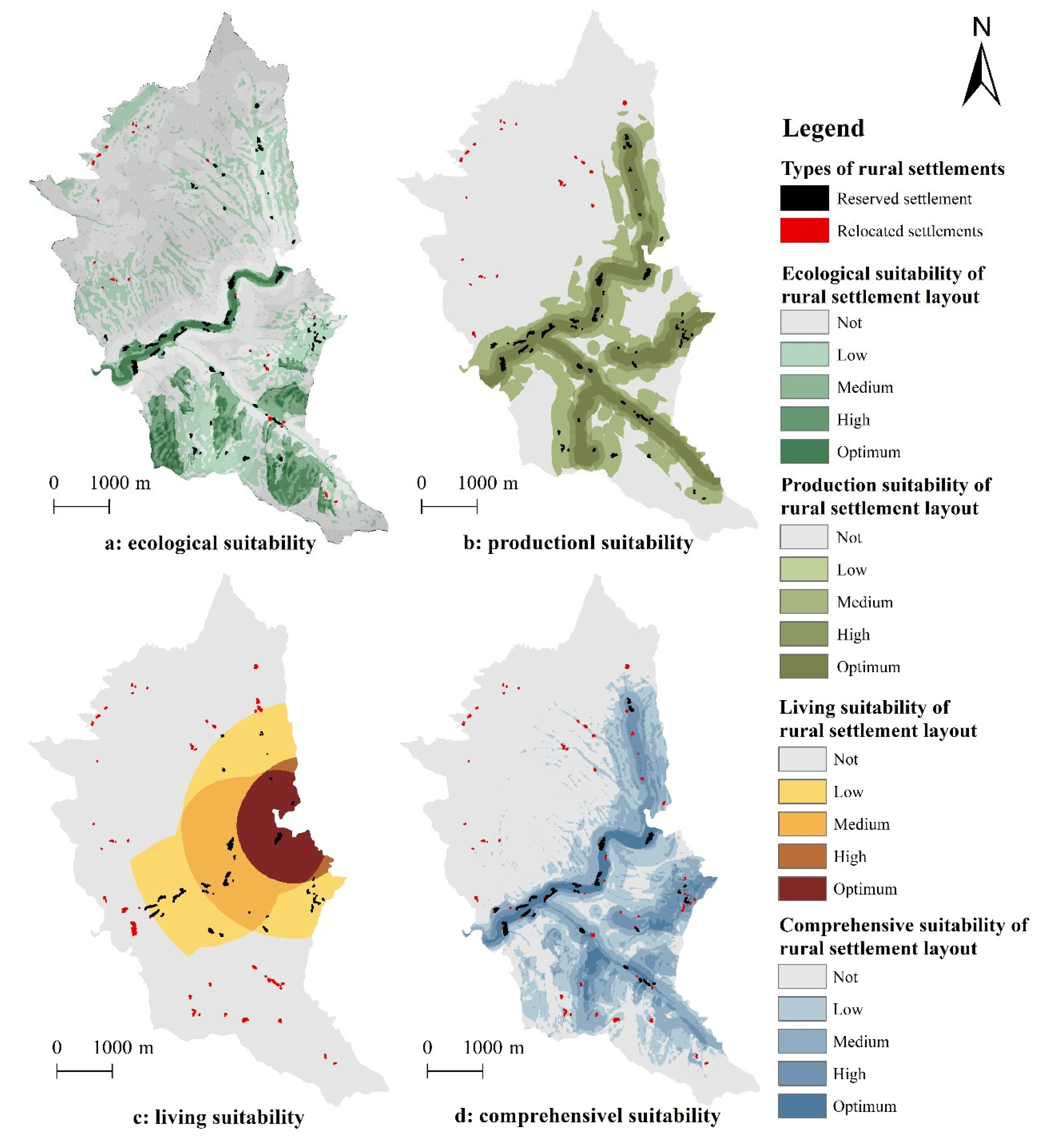
A rural settlement is a specific physical space that can meet the needs of farmers’ production activities and everyday life. At the same time, it is constrained by natural conditions such as topography, geology, hydrology, and so on [
41]. In contrast with plain areas, the hilly and mountainous areas where Pingba is located has greatly constrained the selection of new sites for rural settlements. On the one hand, the undulating highlands and interspersing of mountains and rivers have made it difficult for rural settlements to be centrally distributed on a large scale. On the other hand, the mountainous terrain has made the distribution of cultivated land resources irregular and unbalanced, and it has been difficult to establish farming and residential spaces adjacent to each other. Therefore, the suitability of production, living, and ecological spaces must be considered in the siting of new rural settlements. Based on the above considerations, an evaluation indicator system for the multidimensional suitability of rural settlements was constructed including ecological, productive, and living suitability, with a total of 14 indicators (
Table 1).
Ecological suitability reflects the natural conditions of rural settlements’ spatial layout; it includes slope, elevation, distance from rivers, geological disaster risk, and ecological function [
36]. Among these components, the ecological function is an important factor affecting the layout of rural settlements in mountainous areas. China has implemented a strict ecological protection redline system in the region. This ecological redline has divided the region into ecological protection zones and nonecological protection zones. Rural settlements located within the ecological protection zone have not benefitted from basic development conditions and have had to be relocated and resettled as part of ecological poverty alleviation and relocation projects. Therefore, the suitability of rural settlements’ arrangements within the ecological protection zone has been low.
Production suitability reflects how easily villagers have engaged in production activities; it includes how far farmers are from their fields and from the road. Because our study area was located in the center of the subtropical humid monsoon area, which is always humid and rainy, we found that water was not the main factor affecting the layout of rural settlements and that production activities were closely related to farmers’ livelihoods. As China has urbanized, many rural laborers have been drawn to cities for jobs, which has resulted in changes in the ways in which farmers make their living. Indeed, some farmers have begun to leave their farms to work seasonally through part-time employment. Part-time jobs have reduced farmers’ dependence on cultivated land, and the extent to which farmers have taken up part-time jobs has determined their willingness to relocate. Migrant families have been relatively more likely to move away from cultivated land. Among these families, some peasant households have begun relying entirely on working these jobs for their income, away from agricultural production activities. These farmers have no longer needed to be close to the fields, and it has been more suitable for them move to places with a better transportation system. Therefore, how farmers make their living is an important factor affecting productive suitability in the layouts of rural settlements.
Living suitability in rural settlements reflects how appropriate the conditions in the villagers’ everyday lives are; it includes the convenience of travel and living conditions [
42]. How convenient it is to travel in rural settlements is captured by some indicators related to distance, such as the distance to the main road, the town, and the local clinic [
43]. Living conditions in rural settlements measure the utilization of these rural settlements; this measure includes settlement scale, per capita living space, and building structures. In hilly and mountainous areas, the scale of rural settlements is closely related to the adequateness of the infrastructure that is used by villagers in their everyday lives. The larger the scale of rural settlements and the greater the number of residents, the easier it is to reduce the cost of infrastructure construction. At the same time, moderately concentrated occupation also helps to release the potential of constructible land and optimize patterns of land use. The per capita living area is an important index affecting the suitability of rural settlements. When this area is too small, villagers’ quality of life is affected; if it is too large, it causes extensive use of land resources. In practice, each region in China has made standard provisions for a per capita living area that is tailored to the actual situation in each of these regions. Chongqing stipulates that the per capita living space in rural areas shall not exceed 30 m
2. Building structures have affected the suitability of rural settlement life in many ways. On the one hand, the architectural structure is related to the rational use of residential space; on the other hand, the architectural structure is an important factor affecting residential safety in rural settlements. Reinforced concrete structures are safer than traditional wooden structures and help to improve the quality of villagers’ living space.
The above index system includes both spatial and objective indicators. Among them, livelihood type, settlement scale, per capita living space, and building structure represent objective indicators, which means that these indicators reflect the characteristics of individuals living in rural settlements. In addition, other indicators are spatial indicators, which can be used not only to reveal the current layout status of rural settlements but also to indicate the overall geographical spatial pattern of a region and the potential suitable location of rural settlement layouts. This objective index is used to evaluate the rural settlement patch, while the spatial index is used to evaluate either the rural settlement patch or a certain spatial area.
3.2. Evaluation Model and Method
To comprehensively measure the multidimensional suitability of rural settlement spaces, each factor was divided into different levels according to the existing classification criteria and related research [
35,
39,
44]. The higher the score was, the better the suitability. Factors related to distance were modified according to the farmers’ actual needs, which had been reported in the field surveys. The weight of each index was calculated by the analytic hierarchy process (AHP), and the comprehensive score of suitability was calculated by a multifactor comprehensive evaluation model. The formula is
where
refers to the comprehensive suitability score of the rural settlement layout,
refers to the standardized value of each indicator, and
is the weight of indicators.
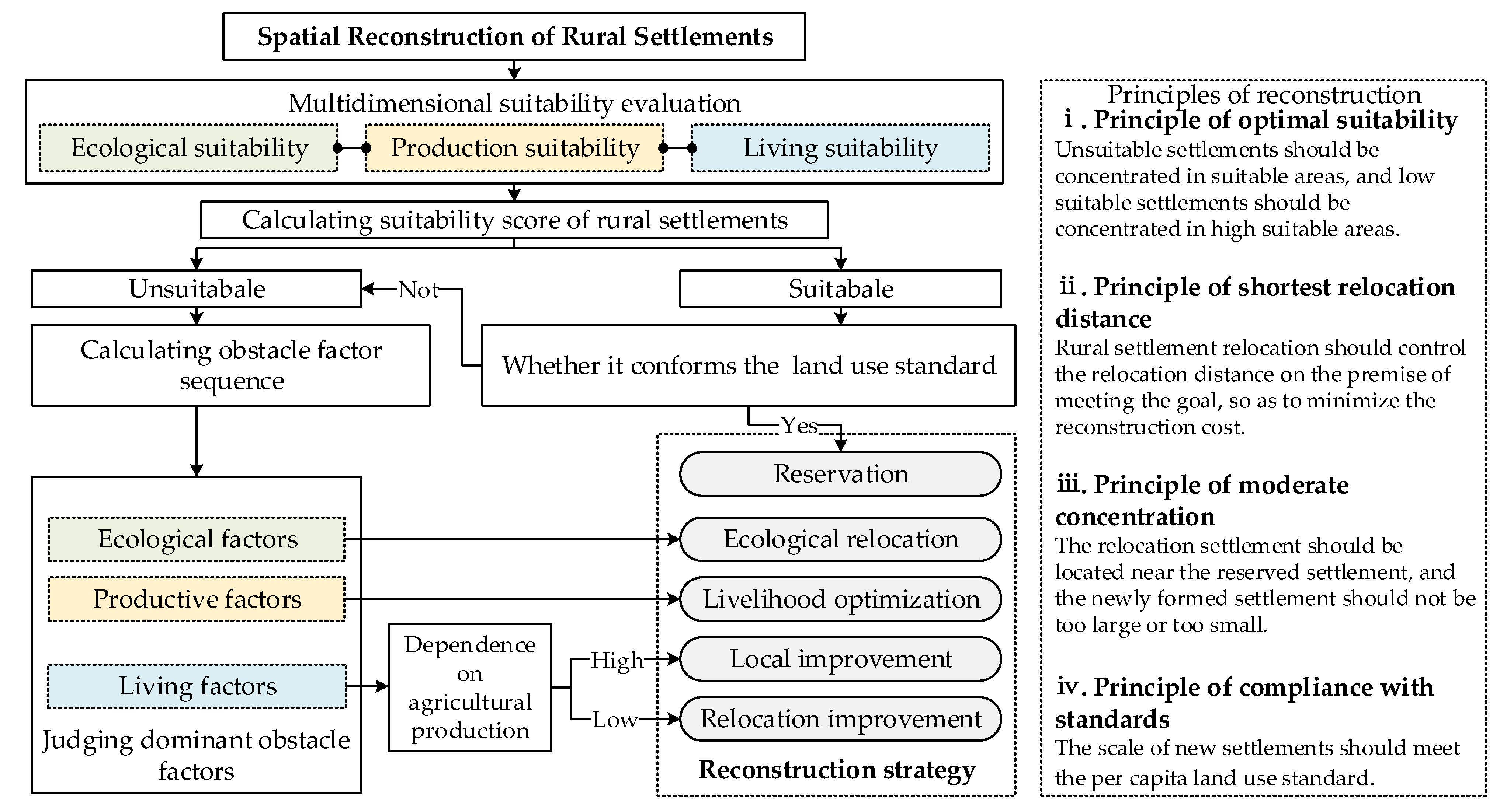
3.3. Rural Settlement Classification and Reconstruction Strategy
The comprehensive suitability score reflected the current level of rural settlement utilization. The more unsuitable rural settlements were, the greater they needed to be relocated and reconstructed. However, different rural settlements showed different utilization conditions, so it was necessary to formulate differentiated relocation strategies according to the characteristics of rural settlements. Therefore, we introduced the obstacle degree model to calculate the factors hindering the individual suitability of rural settlements and formulate targeted relocation strategies according to the differences in dominant obstacles. The formula for the obstacle model is as follows [
45]:
where
represents the obstacle degree of a single index or unilateral suitability to the suitability of individual rural settlements; the higher the score of the obstacle degree is, the greater the obstacle for the comprehensive suitability of rural settlements.
refers to the standardized value of each indicator, and
is the weight of indicators or categories. When ranking the indicators according to the obstacle degree, we can obtain the obstacle degree sequence for each rural settlement.
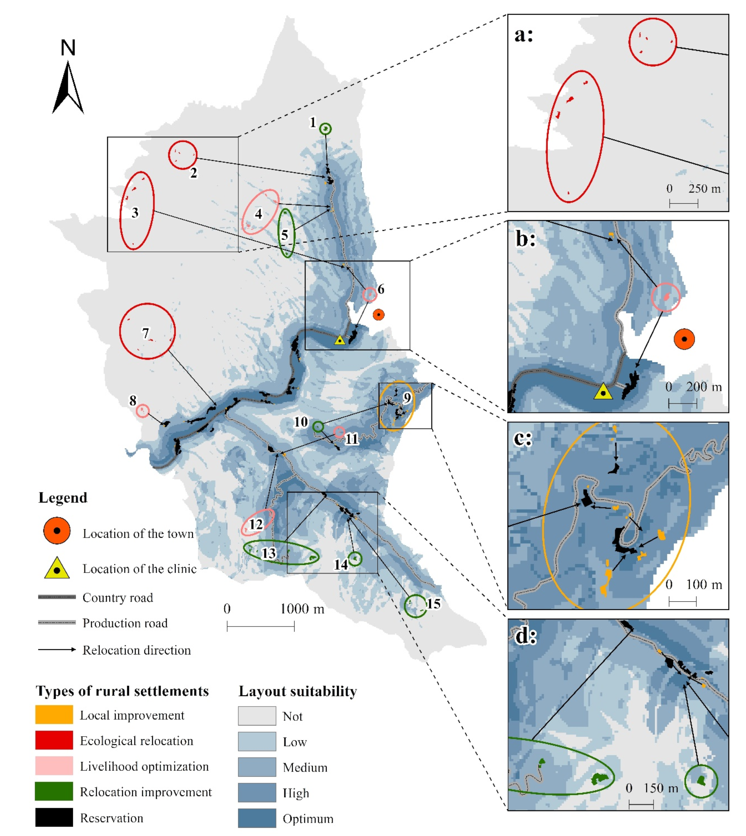
According to the suitability score and obstacle factor sequence, we divided the current rural settlements into different types to formulate differentiated relocation strategies. First, according to the suitability score, rural settlements were divided into two categories: suitable and unsuitable. We believed that when the comprehensive suitability score was lower than 2.4 (converted by 60% of the percentage system), it was not appropriate. Thus, suitable rural settlements could be preserved, while unsuitable ones needed to be optimized through relocation or other measures. According to the rural land management standard issued by the Chongqing government, the per capita rural settlement land area cannot exceed 30 square meters. Therefore, rural settlements with a comprehensive suitability score of more than 2.4, where the per capita rural settlement land area exceeded the standard, were also classified as unsuitable. According to the main obstacle factors, unsuitable rural settlements were divided into three categories: unsuitable ecological conditions, unsuitable productive conditions, and unsuitable living conditions. On this basis, individual factors need to be fully considered in the relocation strategies of these settlements. The livelihood type determines the distance that the settlement can relocate. The building structure, per capita living area, and settlement scale determine whether the settlement needs to be rebuilt.
Rural settlements with unsuitable ecological conditions needed to be relocated to places with good ecological suitability. However, peasant households living only by farming cannot move too far and should be resettled as close to their cultivated land as possible. Rural settlements with unsuitable production conditions needed to be rearranged according to the livelihood to improve their farming radius and production convenience. Improving living conditions in rural settlements with unsuitable living conditions needed to occur based on the actual situation of individual peasant households. It is not necessary to relocate but to build new houses on the original site for the settlements with convenient travel conditions but poor utilization status, such as those with old building structures. The settlements far away from towns, roads, or clinics need to improve travel conditions through relocation, but it will also be different due to livelihood types of farmers. Peasant households who still relied on agricultural production as their main source of livelihood did not benefit from moving to distant places, but they could build new homesteads locally or nearby and could improve their living conditions based on the actual situation. However, peasant households using migrant workers as their main income source should appropriately move to places with better transportation systems to build new houses and improve productive and living conditions.
Based on the above process, we divided rural settlements into five types: reservation, ecological relocation, livelihood optimization, local improvement, and relocation improvement. The reconstruction of rural settlement spaces has been mainly carried out through settlement relocation. The location and direction of rural settlement relocation have become the core of the rural settlement reconstruction process. Due to the harsh geographical conditions in mountainous areas, the livable land area is extremely limited there. At the same time, the development of rural settlements in mountainous areas has faced the dual problem of cultivated land protection and ecological protection. Therefore, the spatial reconstruction of rural settlements in mountainous areas cannot involve large-scale settlement demolition and new construction but should promote the appropriate concentration of rural settlements on the basis of the existing settlement pattern. As shown in
Figure 2, the process of rural settlement reconstruction needs to follow specific principles to avoid excessive costs and social problems caused by large-scale demolition and new agglomerations.
The above process needs to be completed within a village. Pingba village, the case area selected in this paper, is a typical mountainous area. The spatial pattern and ecological environment of rural settlements in Pingba village conform to the general characteristics of mountain areas in China. The dislocation of residential space and industrial space and the extensive utilization of construction land in Pingba village represent the common problems of rural development in China at present. At the same time, in the context of Rural Revitalization, new labor differentiation and rural consumption transformation have emerged in Pingba village, which can reflect the current general trend of rural development in China. This case study can accurately reveal the current utilization characteristics of rural ecological space, production space, and living space in mountainous areas of China, as well as the development direction of rural settlements in the future. The classification, identification, and accurate optimization of rural settlements based on multidimensional suitability can effectively solve the spatial conflicts and imbalances in the development of rural settlements.
5. Discussion
5.1. Policy Implications of Rural Settlement Spatial Reconstruction
Identifying relocated settlements, determining relocation paths, and making policy arrangements after relocation need to be comprehensively and carefully considered [
9,
19]. Although the geographical environment is still one of the important factors restricting the spatial layout of rural settlements in mountainous areas, humanistic and socioeconomic factors have become increasingly important in the location of rural settlements; such factors include how convenient it is for people to travel to their jobs and how adequate the infrastructures and living conditions are [
46]. Our results show that, after considering the suitability of production and living standards, the rural settlements that need to be relocated and retained vary greatly in their location, quantity, and scale. At the same time, within the multidimensional suitability evaluation framework, the mode of rural settlement reconstruction also constitutes more than simply moving from villagers from low suitability to high suitability areas. The diversified reconstruction mode is more conducive to meeting the needs of different farmers and achieving a new spatial equilibrium. On the one hand, this mode is conducive to promoting the appropriate concentration of rural settlements in mountainous areas and coordinating rural ecological spaces, productive spaces, and living spaces. On the other hand, this mode helps in mutually reinforcing the relationship between rural human factors and land-based factors in accordance with the new spatial pattern and helps in the fulfillment of the villagers’ diverse development needs.
Indeed, the spatial reconstruction of rural settlements is a process of spatial trade-off between multiple objectives and constraints. This trade-off is based on different rural regional systems having different socioeconomic conditions, resources, and environmental statuses. It is also due to farmers there having different preferences and rural development having taken different orientations. Especially in mountainous areas, the contradiction between ecological protection and the protection of cultivated land in rural development has been more prominent. This tension has required overall planning for rural settlement reconstruction. It has also meant that the relationship between the reconstruction of rural settlements and the development of rural industry, as well as the overall planning of urban and rural areas, should be taken into account. Moreover, the transformation in the rural spatial layout and structure should be promoted on the basis of the synergy between rural productive space, living spaces, and ecological spaces. Before reconstructing rural settlements, we need to fully consider the internal and external factors influencing modern rural development and try to balance rural multidimensional development goals and multidimensional spaces. On this basis, a comprehensive multidimensional evaluation framework needs to be established. After reconstructing rural settlements, we need to explore an effective path to alleviating the contradiction between rural housing and industry and promoting a moderately centralized residential pattern for farmers and the development of new industries and new formats in harmony with the differences in rural settlement relocation and optimization modes. In particular, changes in farmers’ livelihoods and subsequent livelihood security after relocation should be considered. By means of industrial structure adjustments and professional training, we can enhance the follow-up development ability of relocated people and integrate industry with livelihoods based on the reconstruction of rural settlements.
5.2. Influence of Individual Factors on Rural Settlement Reconstruction
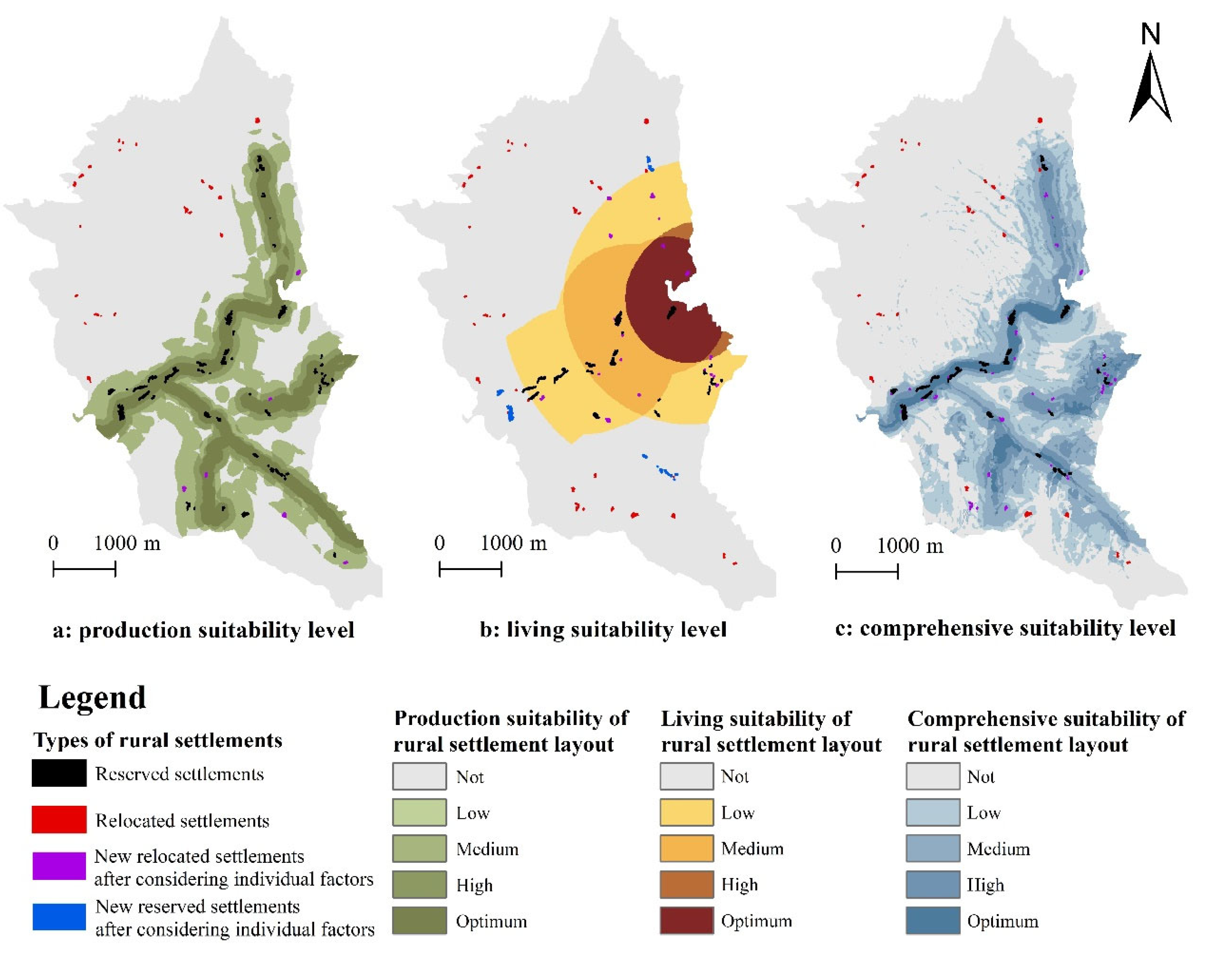
In rural China, the tradition and subjectivity of farmers in the rural social system have determined that the reconstruction of rural settlements cannot be separated from an investigation into farmers’ wishes and behaviors. By establishing a multidimensional suitability evaluation framework for the spatial reconstruction of rural settlements, this research specifically considers the impact of individual factors and household characteristics on rural settlements. For example, objective indicators are added to the evaluation index system to reflect the differences in rural settlement utilization.
Figure 5 reflects the changes in reserved and relocated rural settlements depending on the different suitability levels after considering the characteristics of each rural settlement. We find that, according to productive suitability, the number of rural settlements that need to be relocated or optimized increases by 6 after the indicator measuring farmers’ livelihood type is included in the evaluation system (
Figure 5a). In assessing living suitability—after considering the three indicators of settlement scale, per capita living area, and building structure—15 relocated settlements in Pingba are transformed into reserved settlements, and 23 relocated settlements are added at the same time (
Figure 5b). Most of the newly added settlements are local settlements in which improvement have occurred because the current rural settlements do not meet the rural land management standards, or the building structures are old. Individuals who have moved to reserved settlements have often benefitted from their general location, but these settlements have initially emerged at a large scale. If these settlements are relocated, the cost of spatial reconstruction in these rural settlements will be greatly increased.
After adding multiple individual factors rather than simply considering regional factors, 42 rural settlements in Pingba have been added as relocated settlements, covering a total area of 2.05 hm
2 (
Figure 5c). It can be concluded that, after considering individual factors, the number and scale of rural settlements that need to be relocated have significantly increased. This does not mean that the reconstruction cost has increased. Considering only the suitability of the layout, many large-scale settlements in which more farmers live need to be relocated to places with better suitability, but there are obstacles in practice. On the one hand, in mountainous areas, there is no concentrated contiguous land for new housing. On the other hand, such demolition involves more farmers, who are more likely to create social problems. At the same time, this process leads to the destruction of rural culture. In the process of urbanization and rural transformation, Chinese rural residents have obviously had different economic and social experiences. The geographical spatial pattern of mountainous areas has intensified these differences. Farmers’ family economic characteristics, behavioral preferences, living habits, and other factors will create different needs in the use of rural settlements, thus putting forward new requirements for the use and utility of rural settlements. In the future, the reconstruction of rural settlements will need to fully consider the impact of farmers’ individual characteristics to meet the interests of additional social groups.
5.3. Social Effect of Rural Settlement Reconstruction
Rural settlements are not only the carrier of rural residents’ production activities and daily life, but also the basis for the construction of rural social relations. The reconstruction of rural settlements will inevitably have some social effects. For a long time, China’s rural society has been built on the basis of blood relationship and kinship. This social relationship determines that rural settlements are basically concentrated in families, which means that the neighbors of farmers are brothers and sisters of a large family. However, in the process of urbanization and rural transformation, their livelihoods and economic conditions have been differentiated, thus resulting in the difference in the use of rural settlements. After the reconstruction of rural settlements, this traditional social relationship and neighborhood structure will inevitably be broken. The relocated rural settlements are integrated into the reserved rural settlements, the original kinship is broken up, and a new neighborhood relationship is established.
The new rural settlements meet the production and living needs of different farmers to the greatest extent. The overall suitability level and travel convenience of rural settlements have been greatly improved. However, the formation of new social relations has brought challenges to rural social governance. On the one hand, the relocated farmers have left the place where they have lived for a long time and they are facing changes in living habits and social exchanges, as well as the integration problem into new communities. On the other hand, farmers in the original community are also facing the problem of accepting new neighbors. Fortunately, the relocation involved in this article is carried out in an administrative village, where villagers are familiar with each other and have a good social foundation. The scale of the new settlement after relocation is obviously expanded and developed into a rural community, which is more conducive to arranging public service facilities. The increase in the number of people gathered also makes social activities more frequent and complex. In order to promote the coordinated development between different rural communities and farmers, it is necessary to explore a new rural social governance model. The new model needs to achieve the cooperation between the subjects through various ways, and finally reconstruct various social relations in the village. For example, we can establish new information collection channels based on the community to improve the efficiency of problem handling and feedback in order to solve the problems in rural social development more accurately.
5.4. Application of the Spatial Reconstruction Strategy and Future Work
Based on the results on multidimensional suitability and the sequence of obstacle factor diagnosis, this research divides rural settlements into five different types. Then, according to specific principles of rural settlement reconstruction, a potential reconstruction scheme is proposed. It is worth noting that the scheme proposed in this paper is not fixed or unchanged. Rather, the plan provides a reference basis for rural settlement reconstruction. When determining the real relocation path for rural settlements, we also need to take into account the willingness of farmers to relocate. The results of this paper are largely influenced by interviews with farmers. Through interviews with farmers, on the one hand, we ascertain the individual differences of rural settlement utilization, which is used to guide the classification of rural settlement. On the other hand, we obtained the real needs of farmers for rural settlement relocation through full coverage interviews. Our investigation reveals that Pingba’s villagers are willing to participate in the reconstruction of rural settlements on the premise that their productive and living conditions will improve. However, the situation may differ across villages. Therefore, when local governments promote the implementation of rural settlement reconstruction, they must establish a broad base that can fully reflect farmers’ willingness because rural settlement reconstruction will eventually impact each individual villager.
Due to limitations in accessing data, this paper only considers individual factors in the process of formulating the reconstruction plan. In the future, we need to obtain more data on farmers’ characteristics through interviews and establish a more comprehensive evaluation system for rural settlement reconstruction. The addition of multivariate data puts forward higher requirements for the accuracy of rural settlement evaluation. In terms of model establishment, an intelligent optimization algorithm can be introduced to simulate rural settlement reconstruction in the future. This model is conducive to bringing multidimensional objectives and multiple constraints into a unified analysis framework to calculate and improve the objectivity of the final plan. At the same time, when formulating rural settlement reconstruction strategies, it is necessary to set up different development scenarios and compare the cost-effectiveness of different strategies.
6. Conclusions
Rural settlement reconstruction is a systematic project that needs to consider various objectives at the same time. In the context of rural revitalization, rural settlement reconstruction not only is an important means to optimize the structure of land use and intensify land use, but it also undertakes the function of rural governance and modernization. In addition, as Chinese rural residents depend on rural settlements for their livelihoods, a series of reconstruction processes—such as rural settlement demolition and resettlement—will inevitably have an impact on their productive and living habits and social relations, especially in mountainous areas where villages are often relocated far away. This paper proposes a framework for the reconstruction of rural settlements based on multidimensional suitability, which combines the suitability of ecology, production, and livelihoods. At the same time, the framework integrates the objective factors that reflect the individual differences of settlements. This framework is applied to the practice of rural reconstruction in Pingba. The results show that there are great differences in the number, scale, and spatial distribution of relocated and reserved settlements based on different suitability dimensions.
(1) According to our evaluation of multidimensional suitability, a total of 74 rural settlements in Pingba need to be relocated or optimized, and this number is higher than if unilateral suitability were considered. After comprehensively analyzing the results of the suitability evaluation and obstacle factor diagnosis, we divide the rural settlements in Pingba into five categories. (2) According to the principle of rural settlement reconstruction, a potential reconstruction scheme is proposed. The reconstruction mode in rural settlements is more diversified after considering the multidimensional suitability and individual differences among the settlements. Rural settlements that need to be demolished and relocated have formed multiple types of clusters, and space integration and optimization occur at the center of reserved settlements. After reconstruction, the number of rural settlements in Pingba has decreased significantly, and the average size of the settlements has increased significantly. Moreover, these settlements have formed a new pattern of moderately centralized residential areas in the mountainous areas. (3) This study also tells us that the influence of settlements’ individuality on the reconstruction of rural settlements is discernable. In the future, we need to further investigate the characteristics of each farming family as a whole and analyze the impact of social and economic factors—such as production and living conditions—on the demolition and relocation process in rural settlements. Rural settlement reconstruction does not only entail the optimization of and adjustment in rural residents’ living location, but it is also an important conduit for rural spatial reorganization and rural social relationship reconstruction. In the future, we should pay more attention to the spatial effect of—and social response to—rural settlement reconstruction.


