
An International Library for Land Cover Legends: The Land Cover Legend Registry


 ,
, 
 , , and
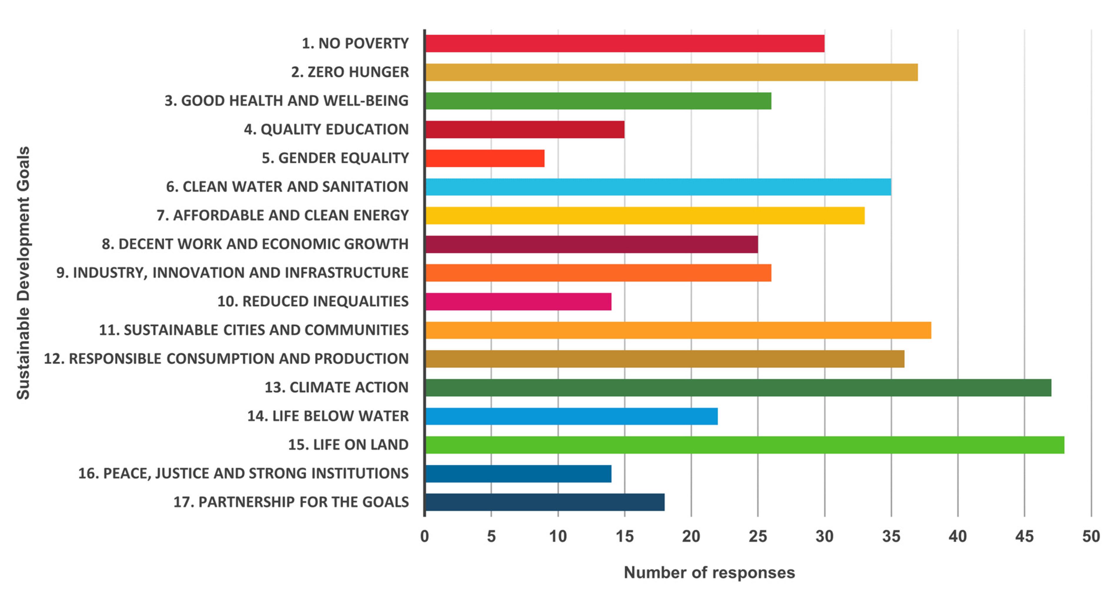
Abstract
1. Introduction
2. Land Cover Legend Registry Development
2.1. Land Cover User Need Assessment
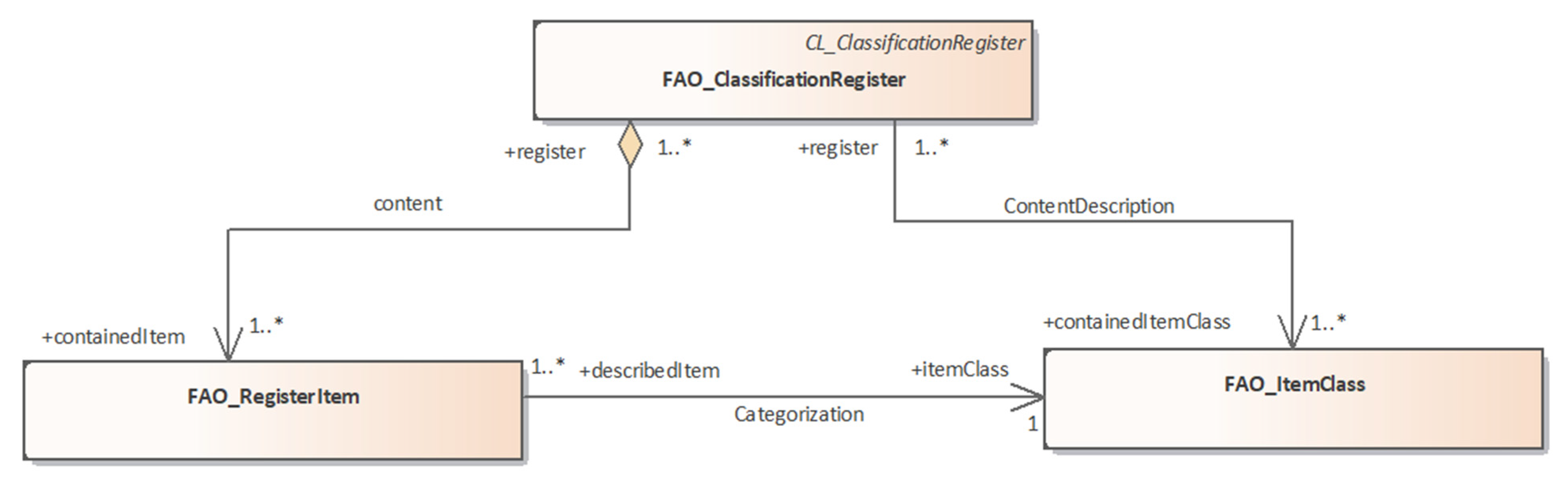
2.2. Land Cover Database
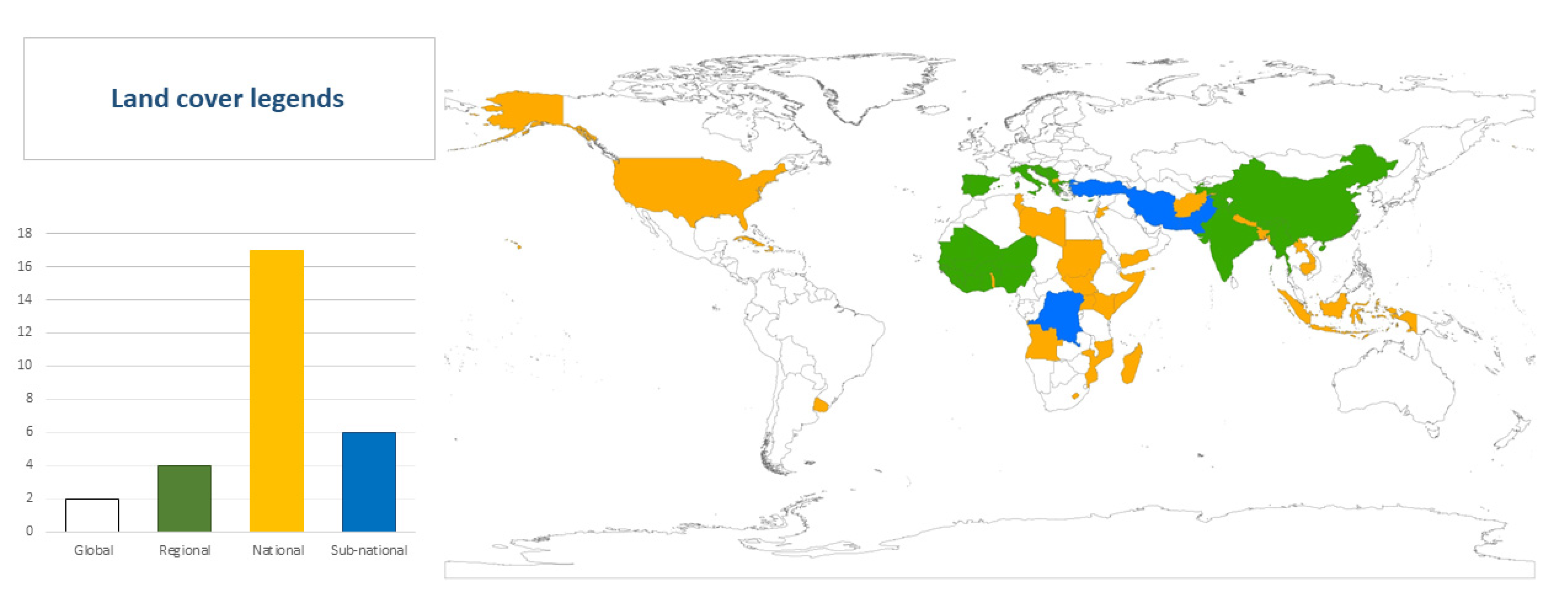
2.3. Land Cover Legends
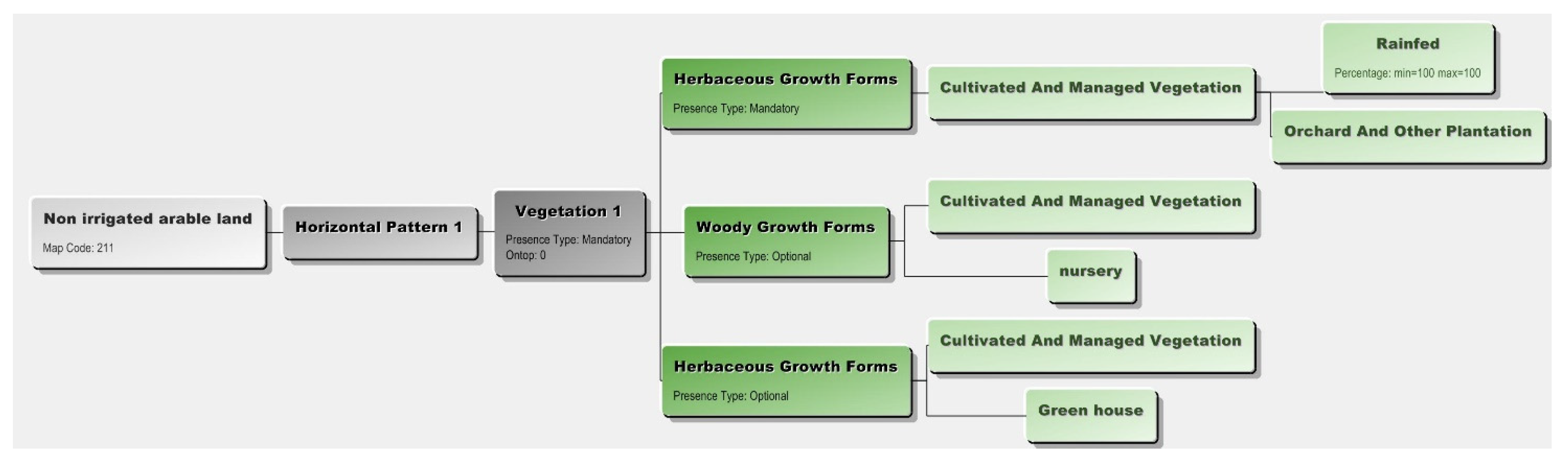
- Country- or region-specific legend available and translated to LCML, e.g., non-irrigated arable land [30] translated into LCML using LCCS version three (LCCS3) software. This class was translated as “herbaceous growth forms” with the characteristics “cultivated and managed” and “rainfed”. With an “optional” presence type of the LCML element “woody growth form” defined by a standard characteristic as “Orchard and other Plantation” (Figure 3);
2.4. Land Cover Legend Registry Platform
2.5. Connectivity to Other Platforms
2.6. Availability of Land Cover Datasets in the Registry
3. Discussion
3.1. Land Cover Data for All
3.2. Semantic Interoperability and Comparison
3.3. Connectivity, Multi-Languages, and Multiple Formats
3.4. Sustainability of the Registry—Future Aspect
4. Conclusions
Author Contributions
Funding
Institutional Review Board Statement
Informed Consent Statement
Data Availability Statement
Acknowledgments
Conflicts of Interest
References
- Jhariya, M.K.; Banerjee, A.; Meena, R.S. Importance of Natural Resources Conservation: Moving toward the Sustainable World. In Natural Resources Conservation and Advances for Sustainability; Elsevier: Amsterdam, The Netherlands, 2022; pp. 3–27. [Google Scholar] [CrossRef]
- The Intergovernmental Panel on Climate Change (IPCC). Climate Change 2022—Impacts, Adaptation and Vulnerability—Summary for Policymakers. 2022. Available online: https://www.ipcc.ch/report/ar6/wg2/ (accessed on 1 June 2022).
- United Nations Committee of Experts on Global Geospatial Information Management (UN-GGIM). The Global Fundamental Geospatial Data Themes. 2019. Available online: https://ggim.un.org/documents/Fundamental%20Data%20Publication.pdf (accessed on 30 May 2022).
- Organisation for Economic Cooperation and Development (OECD). Towards Sustainable Land Use: Aligning Biodiversity, Climate and Food Policies; OECD Publishing: Paris, France, 2020; p. 158. [Google Scholar] [CrossRef]
- United Nations Framework Convention on Climate Change (UNFCCC). Adoption of the Paris Agreement. United Nations Climate Change. 2015. Available online: https://unfccc.int/resource/docs/2015/cop21/eng/l09r01.pdf (accessed on 1 May 2022).
- De Wrachien, D. Land Use Planning: A Key to Sustainable Agriculture. In Conservation Agriculture; Springer: Dordrecht, The Netherlands, 2003; pp. 471–483. [Google Scholar] [CrossRef]
- Food and Agriculture Organization of the United Nations (FAO). Impact of the May Conflict Escalation on the Agricultural Area in the Gaza Strip; Food and Agriculture Organization of the United Nations: Rome, Italy, 2021. [Google Scholar] [CrossRef]
- Agidew, A.; Meta, A.; Singh, K.N. The Implications of Land Use and Land Cover Changes for Rural Household Food Insecurity in the Northeastern Highlands of Ethiopia: The Case of the Teleyayen Sub-Watershed. Agric. Food Secur. 2017, 6, 56. [Google Scholar] [CrossRef]
- Latham, J.; Cumani, R.; Rosati, I.; Bloise, M. Global Land Cover SHARE (GLC-SHARE) Database Beta-Release Version 1.0; Food Agriculture Organization of the United Nations (FAO): Rome, Italy, 2014; Volume 29, pp. 1–39. [Google Scholar]
- European Space Agency (ESA). ESA World Cover 10m 2020 V100. 2021. Available online: https://worldcover2020.esa.int/download (accessed on 4 May 2022).
- Friedl, M.; Gray, J. MCD12Q2 MODIS/Terra+Aqua Land Cover Dynamics Yearly L3 Global 500m SIN Grid V006; NASA EOSDIS Land Processes DAAC: Washington, DC, USA, 2019. [CrossRef]
- Sahara and Sahel Observatory (OSS). Sahel and West Africa—Atlas of Land Cover Maps—Strengthening Resilience through Services Related to Innovation, Communication and Knowledge—BRICKS (Benin, Burkina Faso, Chad, Ethiopia, Ghana, Mali, Mauritania, Niger, Nigeria, Senegal, Sudan and Togo; Sahara and Sahel Observatory (OSS): Tunis, Tunisia, 2019. [Google Scholar]
- Comité Permanent Inter-états de Lutte contre la Sécheresse dans le Sahel (CILLS). Landscapes of West Africa: A Window On a Chaning World. Comité Permanent Inter-états de Lutte contre la Sécheresse dans le Sahel (OSS); U.S. Agency for International Development (USAID): Washington, DC, USA, 2016.
- Jalal, R.; Golam Mahboob, M.; Udita, T.S.; Aziz, T.; Masum, S.M.; Costello, L.; Saha, C.R.; Chowdhury, A.A.M.; Salam, A.; Shahrin, F.; et al. Toward Efficient Land Cover Mapping: An Overview of the National Land Representation System and Land Cover Map 2015 of Bangladesh. IEEE J. Sel. Top. Appl. Earth Obs. Remote Sens. 2019, 12, 3852–3861. [Google Scholar] [CrossRef]
- Mosca, N.; Di Gregorio, A.; Henry, M.; Jalal, R.; Blonda, P. Object-Based Similarity Assessment Using Land Cover Meta-Language (LCML): Concept, Challenges, and Implementation. IEEE J. Sel. Top. Appl. Earth Obs. Remote Sens. 2020, 13, 3790–3805. [Google Scholar] [CrossRef]
- Herold, M.; Latham, J.S.; Di Gregorio, A.; Schmullius, C.C. Evolving Standards in Land Cover Characterization. J. Land Use Sci. 2006, 1, 157–168. [Google Scholar] [CrossRef]
- Avtar, R.; Aggarwal, R.; Kharrazi, A.; Kumar, P.; Kurniawan, T.A. Utilizing Geospatial Information to Implement SDGs and Monitor Their Progress. Environ. Monit. Assess. 2020, 192, 35. [Google Scholar] [CrossRef]
- Mushtaq, F.; Ghosh, A.; Jalal, R.; Gauny, J.; Barelli, D.; Moloinyane, S. A Rapid Geospatial Analysis of the Impact of in Madagascar, Malawi, Mozambique, Zambia, and Zimbabwe; Food Agriculture Organization of the United Nations (FAO): Rome, Italy, 2022. [Google Scholar] [CrossRef]
- Schulz, D.; Yin, H.; Tischbein, B.; Verleysdonk, S.; Adamou, R.; Kumar, N. Land Use Mapping Using Sentinel-1 and Sentinel-2 Time Series in a Heterogeneous Landscape in Niger, Sahel. ISPRS J. Photogramm. Remote Sens. 2021, 178, 97–111. [Google Scholar] [CrossRef]
- Chen, B.; Xu, B.; Gong, P. Mapping Essential Urban Land Use Categories (EULUC) Using Geospatial Big Data: Progress, Challenges, and Opportunities. Big Earth Data 2021, 5, 410–441. [Google Scholar] [CrossRef]
- Chiesi, M.; Maselli, F.; Bindi, M.; Fibbi, L.; Cherubini, P.; Arlotta, E.; Tirone, G.; Matteucci, G.; Seufert, G. Modelling Carbon Budget of Mediterranean Forests Using Ground and Remote Sensing Measurements. Agric. For. Meteorol. 2005, 135, 22–34. [Google Scholar] [CrossRef]
- Neeff, T.; De Alencastro Graça, P.M.; Dutra, L.V.; Da Costa Freitas, C. Carbon Budget Estimation in Central Amazonia: Successional Forest Modeling from Remote Sensing Data. Remote Sens. Environ. 2005, 94, 508–522. [Google Scholar] [CrossRef]
- Di Gregorio, A. Land Cover Classification System—Classification Concept; Food Agriculture Organization of the United Nations (FAO): Rome, Italy, 2016; Available online: https://www.fao.org/3/i5232e/i5232e.pdf (accessed on 31 May 2022).
- ISO/TC211/AG13; Interim Report on Land Cover and Land Use Use Cases (Part 2), Report. Advisory Group 13 on Land cover and Land Use. International Organization for Standardization (ISO): Geneva, Switzerland, 2022. Available online: https://sd.iso.org/documents/open/338e880a-15cd-44da-b237-18939815016a (accessed on 31 May 2022).
- Interim Report on Land Cover and Land Use Use Cases (Part 1), Report. Advisory Group 13 on Land cover and Land Use; International Organization for Standardization (ISO): Geneva, Switzerland, 2022. Available online: https://sd.iso.org/documents/open/944d4465-a240-4146-9a64-389afa22f1a3 (accessed on 31 May 2022).
- ISO. Geographic Information—Procedures for Item Registration—Part 1: Fundamentals; International Organization for Standardization (ISO): Geneva, Switzerland, 2015; Available online: https://www.iso.org/standard/54721.html (accessed on 15 May 2022).
- ISO19144-1:2009-ISO/TC211; Geographic Information—Classification Systems—Part 1: Classification System Structure. International Organization for Standardization (ISO): Geneva, Switzerland, 2009. Available online: https://www.iso.org/standard/32562.html (accessed on 31 May 2022).
- O’Brien, D.C.; Di Gregorio, A.; Mushtaq, F.; Henry, M.; Tchana, E.; Mosca, N.; Blonda, P.; Hill, C.; Latham, J.; Muchoney, D. Register Implementation for Land Cover Legends; Food Agriculture Organization of the United Nations (FAO): Rome, Italy, 2021. [Google Scholar] [CrossRef]
- Di Gregorio, A. Land Cover Classification System—User Manual; Food Agriculture Organization of the United Nations (FAO): Rome, Italy, 2016; Available online: https://www.fao.org/3/i5428e/i5428e.pdf (accessed on 31 May 2022).
- European Environment Agency. Corine Land Cover 2018 (Vector)—Version 20. 2019. Available online: https://sdi.eea.europa.eu/catalogue/geoss/api/records/53ef1493-e7a1-4216-b043-87a7c2a5a68d (accessed on 18 May 2022).
- Food and Agriculture Organization of the United Nations (FAO). Land Cover of Himalaya Region—FAO Map Catalog. Available online: https://data.apps.fao.org/map/catalog/srv/eng/catalog.search#/metadata/46d3c2ef-72c3-4f96-8e32-40723cd1847b (accessed on 18 May 2022).
- GoB. Land Cover Atlas of Bangladesh 2015; Forest Department, Ministry of Environment, Forest and Climate Change, Government of the People’s Republic of Bangladesh: Dhaka, Bangladesh, 2020. Available online: http://bfis.bforest.gov.bd/library/land-cover-atlas-of-bangladesh-2015/ (accessed on 30 May 2022).
- Food and Agriculture Organization of the United Nations (FAO). Land Cover Legend Registry (LCLR). Available online: https://www.fao.org/hih-geospatial-platform/en/resources/land-cover-legend-registry/ (accessed on 31 May 2022).
- Food and Agriculture Organization of the United Nations (FAO). FAO-LCLR—Datasets—“FAO Catalog”. Available online: https://data.apps.fao.org/catalog/dataset/land-cover-legend-registry (accessed on 31 May 2022).
- Food and Agriculture Organization of the United Nations (FAO). SEPAL Recipes—SEPAL Documentation. Available online: https://docs.sepal.io/en/latest/cookbook/index.html (accessed on 31 May 2022).
- GoB. Land Representation of Bangladesh (In Support of REDD+) Forest Department, Ministry of Environment, Forest and Climate Change, Government of the People’s Republic of Bangladesh. 2017. Available online: http://bfis.bforest.gov.bd/library/land-representation-system-of-bangladesh/ (accessed on 31 May 2022).
- Food and Agriculture Organization of the United Nations (FAO). Land Cover Atlas of Jordan; FAO: Rome, Italy, 2019; Volume 2012, Available online: https://www.fao.org/geospatial/resources/detail/en/c/1202563/ (accessed on 31 May 2022).
- Food and Agriculture Organization of the United Nations (FAO). The Islamic Republic of Afghanistan—The Land Cover Atlas; FAO: Rome, Italy, 2016; Available online: https://www.fao.org/publications/card/en/c/cc0ac143-38ed-41f0-b7c6-2342ffa7f0e6/ (accessed on 31 May 2022).
- Comber, A.J.; Fisher, P.F.; Wadsworth, R.A. Land Cover: To Standardise or Not to Standardise? Comment on ‘Evolving Standards in Land Cover Characterization’ by Herold et Al. J. Land Use Sci. 2008, 2, 283–287. [Google Scholar] [CrossRef][Green Version]
- Global Agro Ecological Zones (GAEZ). Towards Efficient and Sustainable Food and Bio-Energy Security in Thailand Global Agro Ecological Zones Key Results; Food Agriculture Organization of the United Nations (FAO): Rome, Italy, 2022; pp. 1–2. Available online: https://www.fao.org/documents/card/en/c/CB4766EN/ (accessed on 31 May 2022).
- Food and Agriculture Organization of the United Nations (FAO). Remote Sensing for Water Productivity|Food and Agriculture Organization of the United Nations. Available online: https://www.fao.org/in-action/remote-sensing-for-water-productivity/resources/publications/wapor-publications/en/ (accessed on 27 June 2022).


Publisher’s Note: MDPI stays neutral with regard to jurisdictional claims in published maps and institutional affiliations. |
© 2022 by the authors. Licensee MDPI, Basel, Switzerland. This article is an open access article distributed under the terms and conditions of the Creative Commons Attribution (CC BY) license (https://creativecommons.org/licenses/by/4.0/).
Share and Cite
Mushtaq, F.; Henry, M.; O’Brien, C.D.; Di Gregorio, A.; Jalal, R.; Latham, J.; Muchoney, D.; Hill, C.T.; Mosca, N.; Tefera, M.G.; et al. An International Library for Land Cover Legends: The Land Cover Legend Registry. Land 2022, 11, 1083. https://doi.org/10.3390/land11071083
Mushtaq F, Henry M, O’Brien CD, Di Gregorio A, Jalal R, Latham J, Muchoney D, Hill CT, Mosca N, Tefera MG, et al. An International Library for Land Cover Legends: The Land Cover Legend Registry. Land. 2022; 11(7):1083. https://doi.org/10.3390/land11071083
Chicago/Turabian StyleMushtaq, Fatima, Matieu Henry, C. Douglas O’Brien, Antonio Di Gregorio, Rashed Jalal, John Latham, Douglas Muchoney, Chris T. Hill, Nicola Mosca, Michael Golmame Tefera, and et al. 2022. "An International Library for Land Cover Legends: The Land Cover Legend Registry" Land 11, no. 7: 1083. https://doi.org/10.3390/land11071083
APA StyleMushtaq, F., Henry, M., O’Brien, C. D., Di Gregorio, A., Jalal, R., Latham, J., Muchoney, D., Hill, C. T., Mosca, N., Tefera, M. G., Morteo, K., Franceschini, G., Ghosh, A., Tchana, E., & Chen, Z. (2022). An International Library for Land Cover Legends: The Land Cover Legend Registry. Land, 11(7), 1083. https://doi.org/10.3390/land11071083