
Volcanic Landforms and Landscapes of the East Carpathians (Romania) and Their Geoheritage Values

Abstract
:1. Introduction
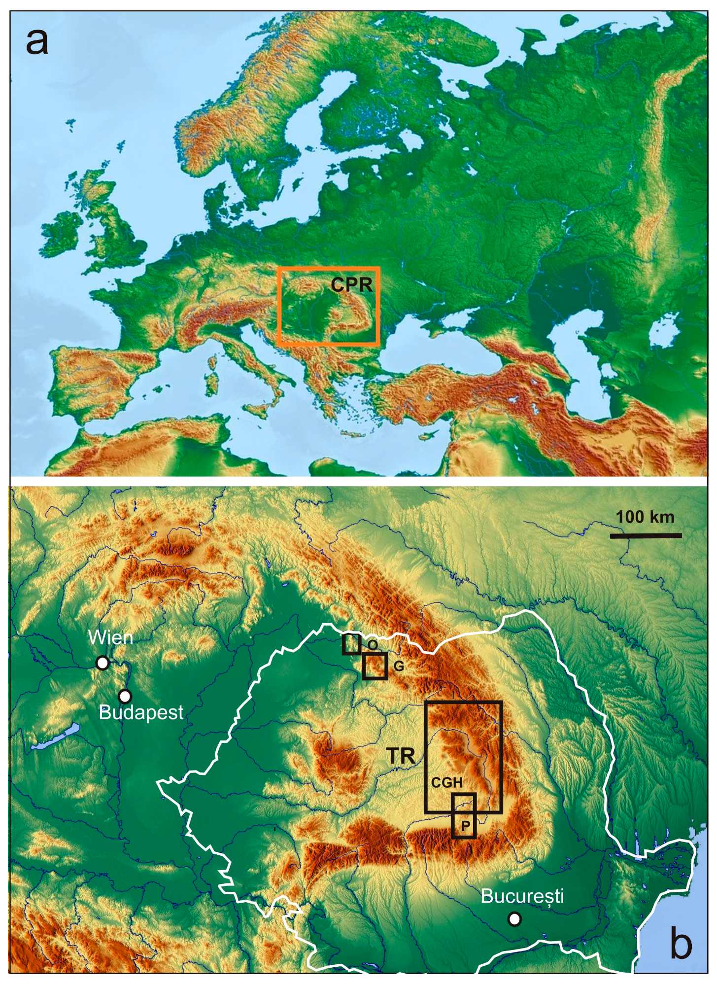
2. Geographic and Geologic Background
3. General Volcanic Evolution and Volcanic Structures
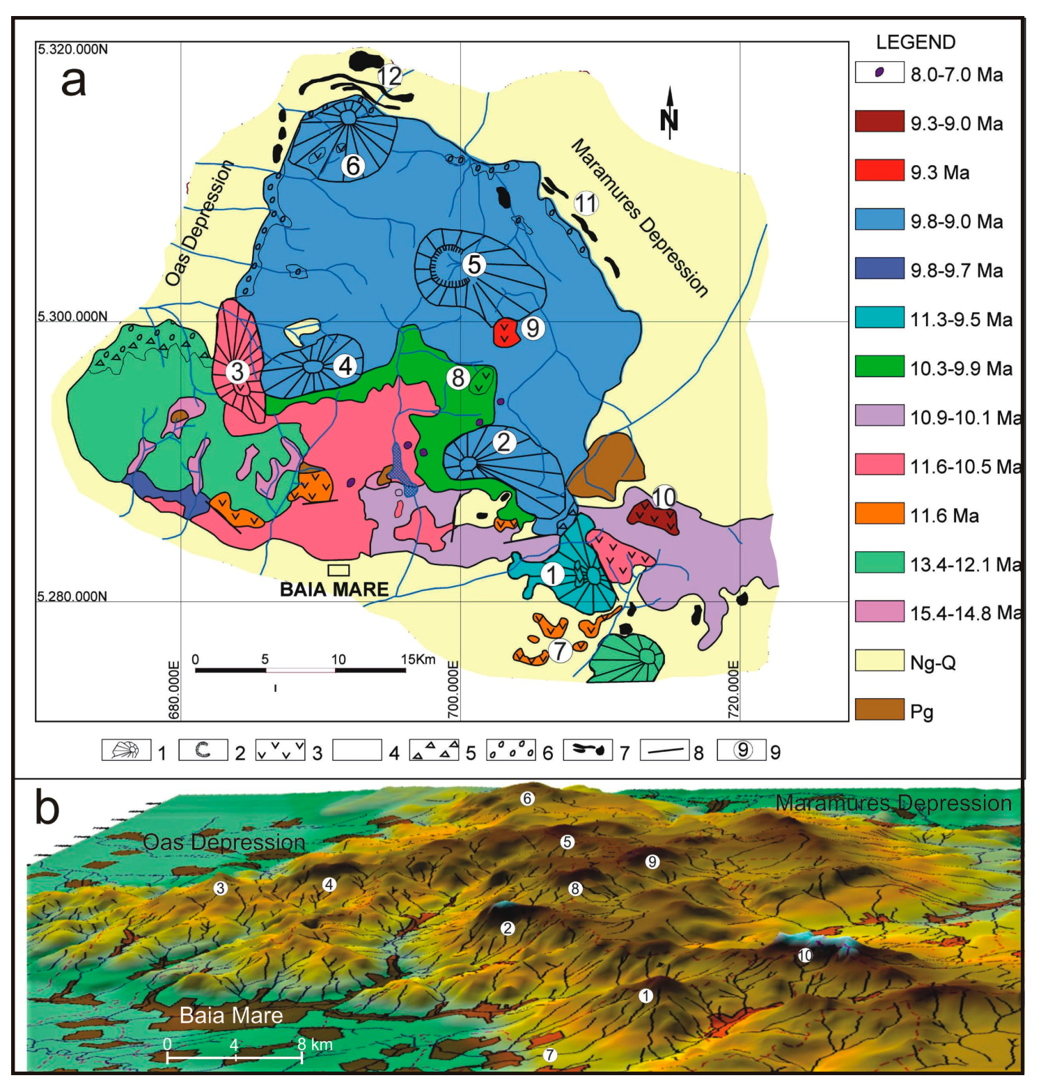
4. The Neogene Oaş–Gutâi Segment
4.1. Volcanic Evolution
4.2. General Volcanological Features
4.3. Volcanic Landforms and Landscapes

| Volcano (Name, Location and Figure Reference) | Volcanic Edifice Type | Morphometry (Extension, Elevation a.s.l.) | Major Landform Features |
|---|---|---|---|
| Mogoşa (Figure 4a,b and Figure 5a) | Composite volcano | 8 km diameter 1246 m | Small peak plateau, elongated slopes toward S and W, much fragmented relief toward SW, impressive steep cliffs at the SE contact with sedimentary deposits |
| Igniş (2 in Figure 4a,b) | Composite volcano | 9 × 4 km 1307 m | Asymmetric topography, wide summit plateau, big escarpment (>100 m high) toward S, residual landforms: rock pillars, towers, and tors (e.g., the ”Igniş Sphinx”) |
| Muntele Mic (3 in Figure 4a,b) | Composite Volcano | 7 × 3 km 1012 m | Steep conical upper edifice, elongated slopes toward N, strongly fragmented relief toward SW and NW |
| Pietroasa (4 in Figure 4a,b) | Composite volcano | 7 × 4 km 1200 m | Elongated shape, conical upper part, strongly fragmented to the N and S by two hydrographic systems, residual and periglacial landforms: cliffs and rock towers (e.g., the ”Oaş Sphinx”) |
| Rotundu (5 in Figure 4a,b) | Composite volcano | 10 × 5 km 1241 m | Large remnant crater (ca. 3 km across) as a semicircular ridge open to the E [26] transformed into a hydrographic catchment area |
| Muntele Bradului (6 in Figure 4a,b) | Composite volcano | 8–9 km diameter 1091 m | Strongly dissected by a hydrographic network developed around the edifice, parasitic remnant cone (Vârful Mare, 1032 m a.s.l.) in the upper part of the edifice |
| Dăneşti-Cetăţele (7 in Figure 4a,b) | Composite dome | 7 × 5 km 675 m | Residual volcanic relief/skeleton-like landform (low-elevation hills with depressions between them), spectacular erosive landforms on volcaniclastic products |
| Breze (8 in Figure 4a,b) | Dome | 3 × 1.5 km 1253 m | Topographically well-individualized, flat-topped, elongated (NE–SW) mountain |
| Pleşca Mare (9 in Figure 4a,b) | Composite dome | 4.5 km diameter 1291 m | Cupola-like mountain of subrounded shape with low angle slopes |
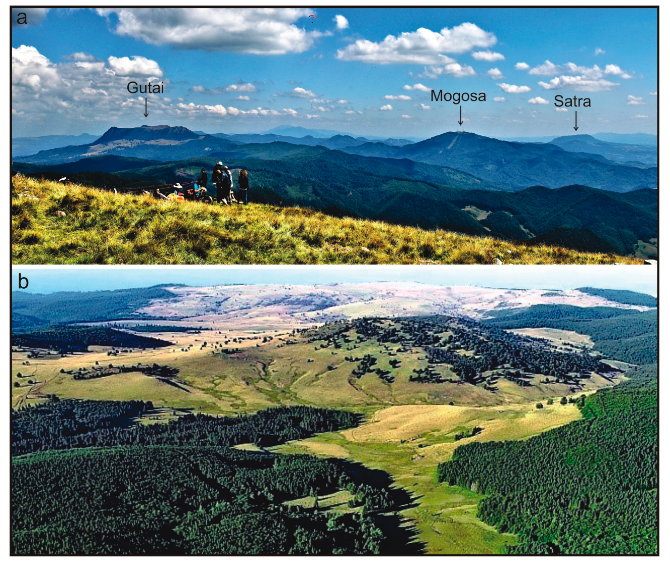
| Gutâi (Figure 4a,b and Figure 5a) | Dome | 4.5 × 2 km 1444 m | Topographically prominent mountain with a large summit plateau bordered by impressive steep cliffs and specific landforms of weathering origin at the NW and the SW edges |
5. The Neogene–Quaternary Călimani–Gurghiu–Harghita Segment
5.1. Volcanic Evolution
5.2. General Volcanological Features
5.3. Volcanic Landforms and Landscapes
- Inherited (i.e., non- or slightly modified) volcanic landforms preserving the most characteristic and easily recognizable features of the original volcanic topography such as the gentle outer slopes of most composite volcanoes, the youngest volcanic domes, a few central crater areas (e.g., those of Ciomadul volcano) and large parts of the western ring-plain of the Gurghiu and Harghita Mountains;
- Landforms modified by syn- and post-volcanic processes other than erosion, i.e., those related to volcano spreading;
- Landforms moderately modified by erosion, with roughly preserved and still recognizable original volcanic topography, such as the central depressions (craters and calderas) of large composite volcanoes (e.g., Călimani caldera, Seaca-Tătarca volcano in the Gurghiu Mountains);
- Landforms strongly modified by erosion, where the original volcanic topography is hardly (or not at all) recognizable: central areas of some of the large composite volcanoes that underwent syn-volcanic collapse events (e.g., Rusca-Tihu) and/or intense post-volcanic erosion (e.g., Jirca), as well as strongly dissected parts of the “volcanic plateau”;
- Anthropic landforms mostly related to mineral exploration/mining activities.
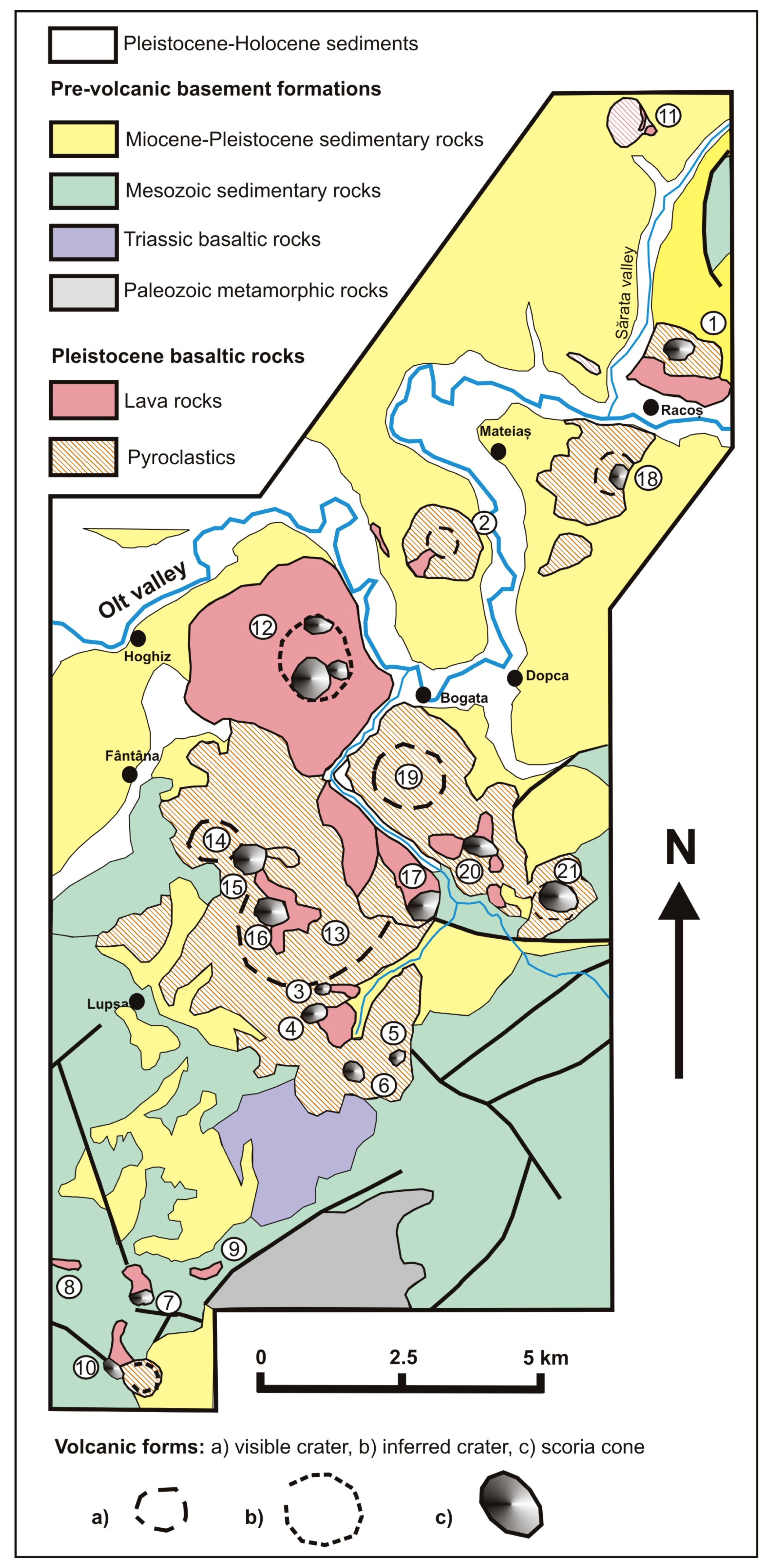
6. The Perșani Pleistocene Alkali Basaltic Volcanic Field
6.1. Volcanic Evolution
6.2. General Volcanological Features
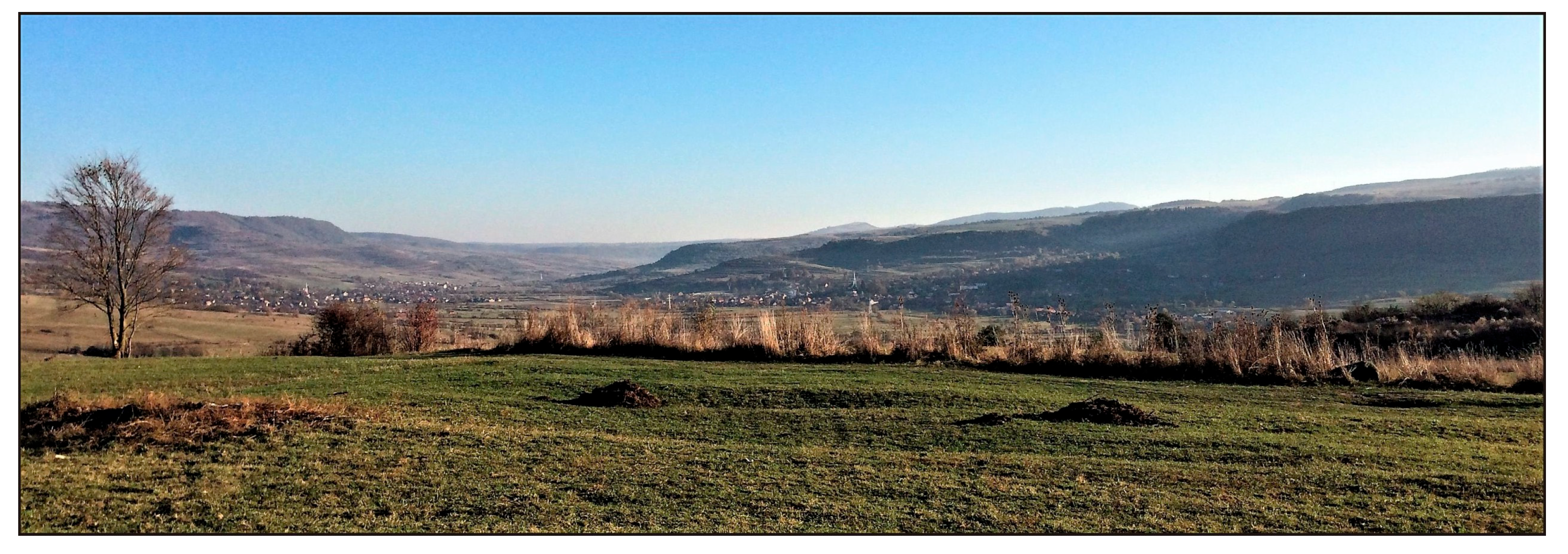
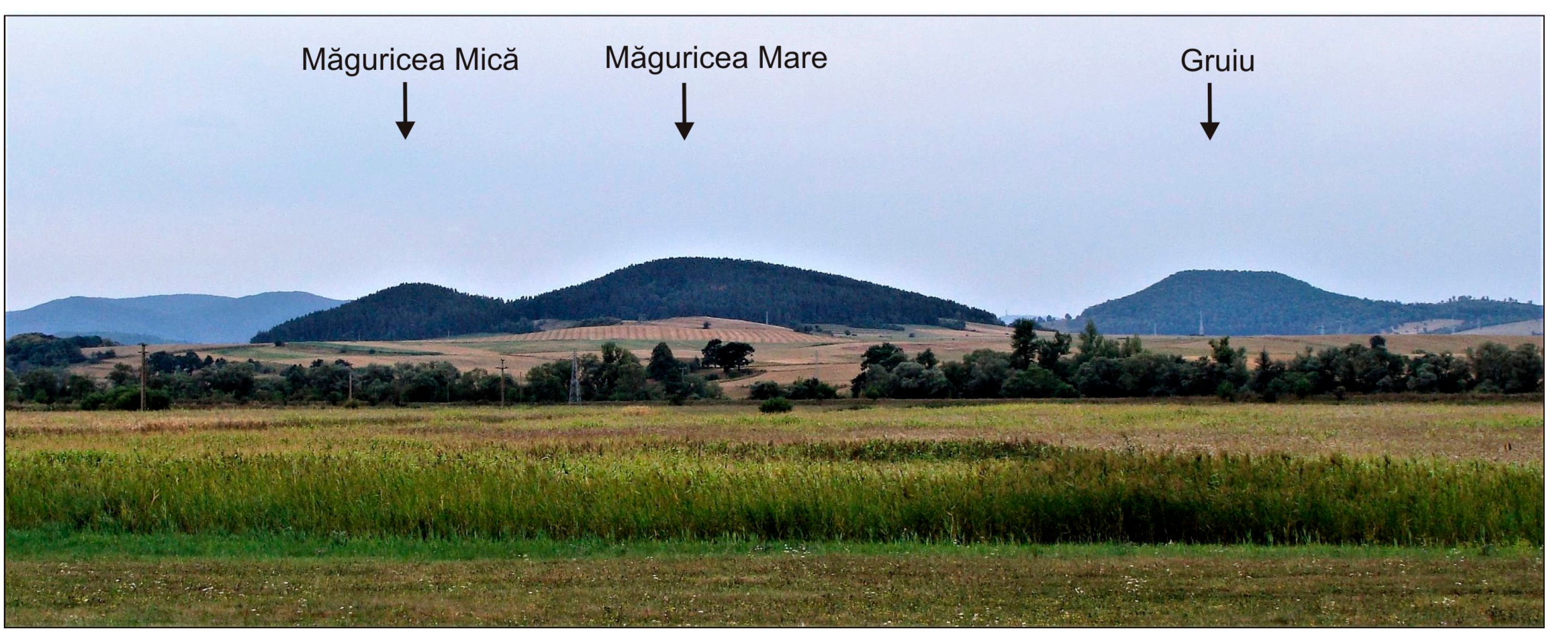
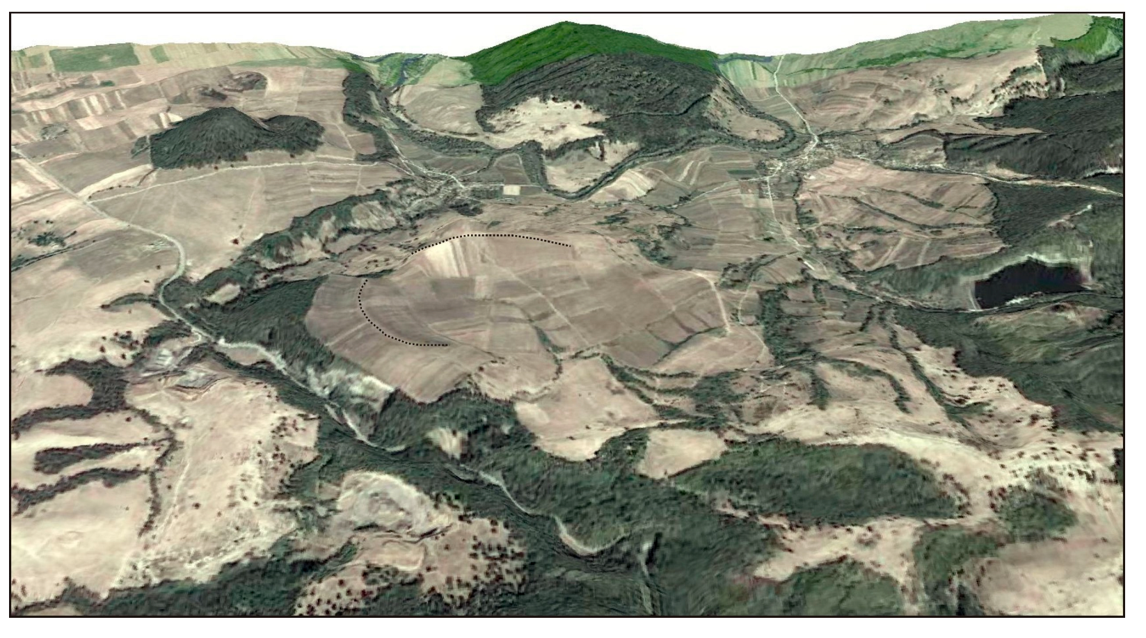
6.3. Volcanic Landforms and Landscapes
7. Discussion
7.1. Original Volcanic Landforms
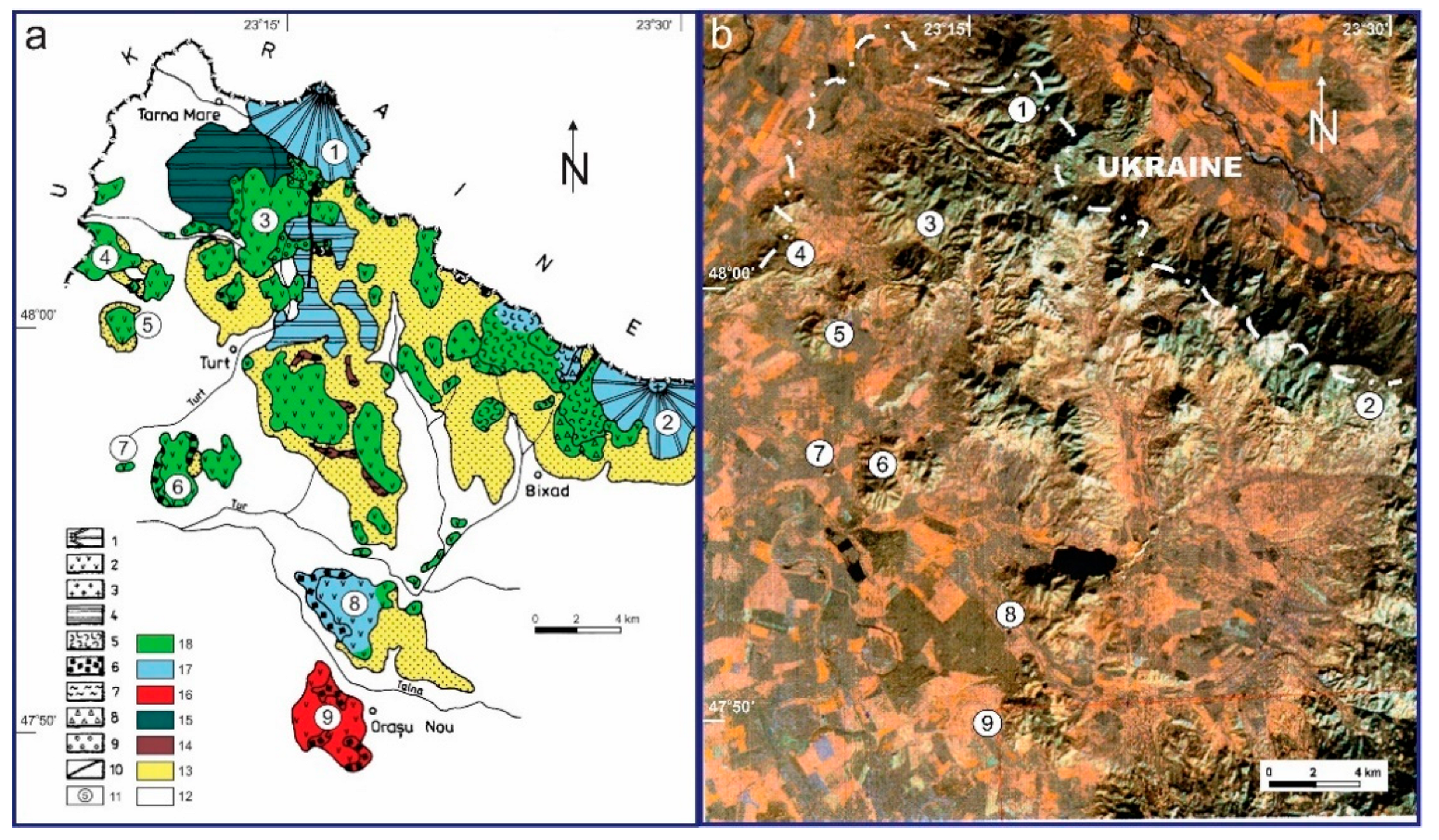
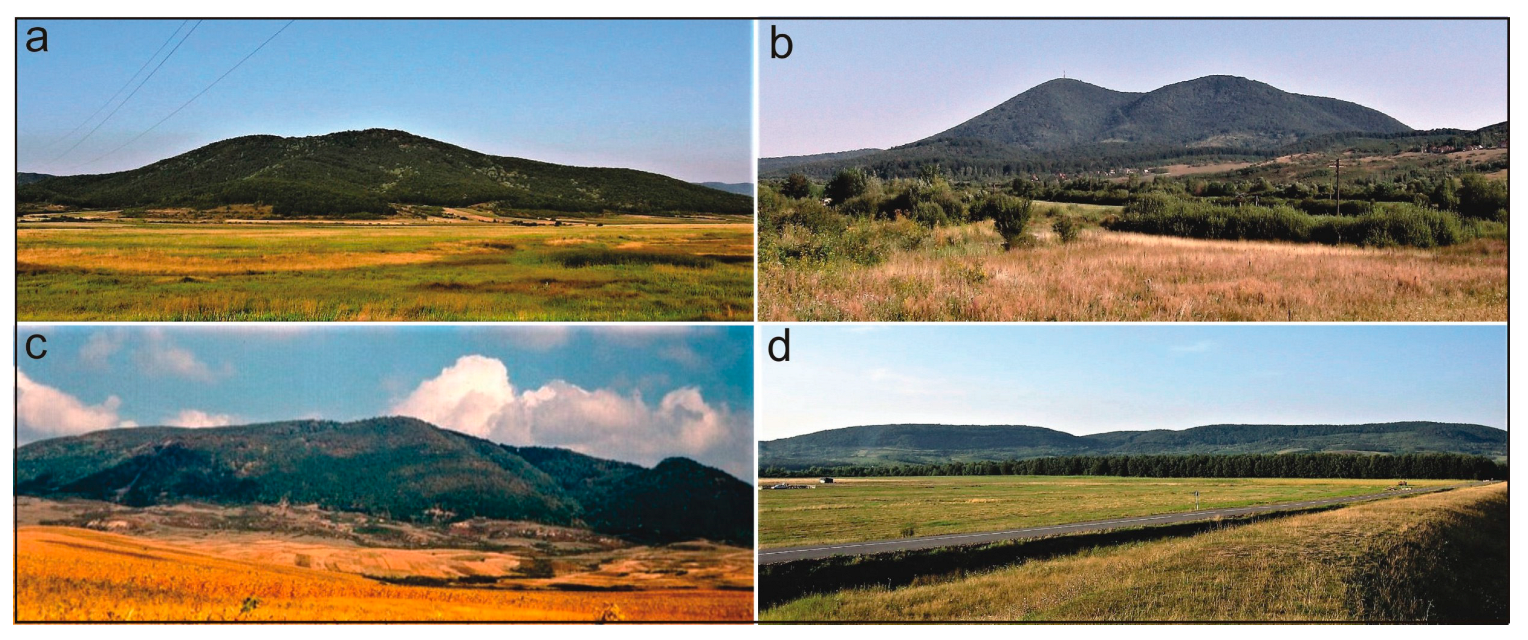
- Volcanic structures emplaced outside the main volcanic area (generally isolated and surrounded by Neogene–Quaternary sedimentary deposits). The most relevant for this category are the andesitic to rhyolitic extrusive domes and dome-coulées at the western and the southern parts of the Oaş Mountains (Pusta Heghii, Pleşcuta, Turulung, Oraşu Nou, Hatu Lung, etc.). Although partially eroded, many of these domes consisting of erosion-resistant coherent lavas have kept their original overall morphology. Another example is the Şatra extrusive dome in the southeastern part of the Gutâi Mountains, located outside of the main volcanic area, which preserved quite well its original morphology despite the fact that it represents one of the oldest volcanic structures (13.2 Ma, Figure 5a);
- The volcanic structures belonging to the youngest eruptive events in their respective local areas. It is the case of some composite/effusive volcanoes of the latest major volcanic events in Gutâi Mountains (e.g., Mogoşa volcano whose activity ceased around 9.5 Ma or Igniş volcano ending his activity around 9.0 Ma). Some large-sized extrusive domes emplaced in the volcanic area of the Gutâi Mountains and surrounded by older volcanic products have partially preserved their original morphology (e.g., Gutâi andesitic dome dated at 9.3–9.0 Ma and Pleşca Mare composite/andesitic–dacitic dome built up at around 9.3 Ma).
7.2. Erosion of the Original Volcanic Landforms
7.2.1. Oaş–Gutâi Segment
7.2.2. Călimani-Gurghiu-Harghita Segment
7.2.3. Perșani Mountains
7.3. Anthropic Alteration of the Pristine Volcanic Landforms
8. Geoheritage Values
8.1. Sites of Geoheritage Relevance in the East Carpathian Volcanic Areas
8.2. Geoparks, Geotrails, and Geotourism
9. Conclusions
- Primary volcanic topography (size, elevation, topography) depending on (1) the style (effusive, explosive, both) and (2) the duration of volcanic activity at individual volcanic centers, (3) syn-volcanic destruction events (e.g., caldera formation, sector collapse/edifice failure) operating during volcanic evolution, and (4) the spatial distribution of the volcanoes (isolated or clustered edifices of various shapes and sizes);
- Syn- and post-volcanic non-erosional deformation processes related to volcano spreading, as proved at the western peripheries of the largest Gurghiu and North Harghita edifices;
- Syn- and post-volcanic erosion of various intensity depending on (1) age of volcanism (decreasing from North-West to South-East along the Călimani-Gurghiu-Harghita segment), (2) contrast of erodibility between volcanic formations and the surrounding basement rocks and between various volcanic lithologies, and (3) varying relief energy (higher in the steeper proximal parts of the composite volcanic edifices as compared to their flatter peripheries).
Author Contributions
Funding
Institutional Review Board Statement
Informed Consent Statement
Data Availability Statement
Acknowledgments
Conflicts of Interest
References
- Săndulescu, M. Geotectonics of Romania; EdituraTehnică: Bucharest, Romania, 1984; p. 336. (In Romanian) [Google Scholar]
- Schreiber, W.E. The Geomorphology of the Harghita Mountains; Editura Academiei Române: Bucharest, Romania, 1994; p. 166. (In Romanian) [Google Scholar]
- Schreiber, W.E.; Unger, E. Some specific aspects of post volcanic relief evolution in the Harghita Mountains. Földtani Közlöny 2006, 136, 285–298, (In Hungarian with English Abstract). [Google Scholar]
- Mac, I. The geomorphology of the Neogene volcanics from the eastern part of the Oaş Mountains. Stud. Univ. Babeş-Bolyai Geogr. 1992, XXXVII, 1–2. (In Romanian) [Google Scholar]
- Faur, C. The Geomorphology of the Oaş Mountains; North University: Baia Mare, Romania, 2011; p. 121. (In Romanian) [Google Scholar]
- Hodor, N. The Igniş-Gutâi mountains. Geomorphological study. Ph.D. Thesis, Babeş-Bolyai University, Cluj-Napoca, Romania, 2002; p. 148. (In Romanian). [Google Scholar]
- Csontos, L.; Nagymarosy, A.; Horváth, F.; Kovác, M. Tertiary evolution of the intra-Carpathian area: A model. Tectonophysics 1992, 208, 221–241. [Google Scholar] [CrossRef]
- Pécskay, Z.; Lexa, J.; Szakács, A.; Seghedi, I.; Balogh, K.; Konecny, V.; Zelenka, T.; Kovacs, M.; Póka, T.; Fülöp, A.; et al. Geochronology of Neogene magmatism in the Carpathian arc and intra-Carpathian area. Geol. Carpath. 2006, 57, 511–530. [Google Scholar]
- Szakács, A.; Pécskay, Z.; Gál, Á. Patterns and trends of time–space evolution of Neogene volcanism in the Carpathian–Pannonian region: A review. Acta Geod. Geophys. 2018, 53, 347–367. [Google Scholar] [CrossRef]
- Seghedi, I.; Downes, H.; Szakács, A.; Mason, P.R.D.; Thirlwall, M.F.; Rosu, E.; Pécskay, Z.; Márton, E.; Panaiotu, C. Neogene-Quaternary magmatism and geodynamics in the Carpathian-Pannonian region: A synthesis. Lithos 2004, 72, 117–146. [Google Scholar] [CrossRef]
- Lexa, J.; Seghedi, I.; Németh, K.; Szakács, A.; Konečný, V.; Pécskay, Z.; Fülöp, A.; Kovacs, M. Neogene-Quaternary Volcanic forms in the Carpathian-Pannonian Region: A review. Cent. Eur. J. Geosci. Open Geosci. 2010, 2, 207–270. [Google Scholar] [CrossRef] [Green Version]
- Németh, K. An overview of the monogenetic volcanic fields of the Western Pannonian Basin: Their field characteristics and outlook for future research from a global perspective. In Updates in Volcanology—A Comprehensive Approach to Volcanological Problems; Stoppa, F., Ed.; In-Tech: London, UK, 2012; pp. 27–52. [Google Scholar]
- Kovacs, M.; Fülöp, A. Neogene volcanism in Oaş Mts, Eastern Carpathians, Romania. Geol. Carpath. 2002, 53, 208–210. [Google Scholar]
- Kovacs, M.; Pécskay, Z.; Crihan, M.; Edelstein, O.; Gabor, M.; Bernad, A. K-Ar study of Neogene volcanic rocks from the Oaş Mts (East Carpathians, Romania). Révue Roum. Geol. 1997, 41, 19–28. [Google Scholar]
- Kovacs, M.; Fülöp, A.; Pécskay, Z. Dome-building volcanic activity in the Oas-Gutai Neogene Volcanic Area, Eastern Carpathians, Romania. Bul. I Shk. Gjeol. Spec. Issue 2014, 1, 230–233. [Google Scholar]
- Fülöp, A. The Onset of the Volcanism in Gutâi Mountains. Paleovolcanological and Paleosedimentological Reconstitutions; Editura Dacia: Cluj-Napoca, Romania, 2003; p. 134. (In Romanian) [Google Scholar]
- Kovacs, M.; Seghedi, I.; Yamamoto, M.; Fülöp, A.; Pécskay, Z.; Jurje, M. Miocene volcanism from the Oaş-Gutâi Volcanic Zone (Eastern Carpathians, România)—Link to the geodynamic processes of Transcarpathian Basin. Lithos 2017, 294–295, 304–318. [Google Scholar] [CrossRef]
- Kovacs, M.; Fülöp, A.; Seghedi, I.; Pécskay, Z. Architecture of volcanic plumbing systems inferred from thermobarometry: A case study from the Miocene Gutâi Volcanic Zone in the Eastern Carpathians, Romania. Lithos 2021, 396–397, 106191. [Google Scholar] [CrossRef]
- Edelstein, O.; Bernad, A.; Kovacs, M.; Crihan, M.; Pécskay, Z. Preliminary data regarding the K-Ar ages of some eruptive rocks from Baia Mare Neogene volcanic zone. Révue Roum. Geol. 1992, 36, 45–60. [Google Scholar]
- Pécskay, Z.; Edelstein, O.; Kovacs, M.; Bernad, A.; Crihan, M. K-Ar age determination of Neogene volcanic rocks from the Gutâi Mts (Eastern Carpathians, Romania). Geol. Carpath. 1994, 45, 357–363. [Google Scholar]
- Kovacs, M.; Fülöp, A. Neogene volcanism in Gutâi Mts (Eastern Carpathians). A review. Stud. Univ. Babeş-Bolyai Geol. 2003, 48, 3–16. [Google Scholar] [CrossRef] [Green Version]
- Kovacs, M.; Pécskay, Z.; Fülöp, A.; Jurje, M.; Edelstein, O. Geochronology of the Neogene intrusive magmatism of the Oaş-Gutâi Mts, Eastern Carpathians, NW Romania. Geol. Carpath. 2013, 64, 483–496. [Google Scholar] [CrossRef] [Green Version]
- Edelstein, O.; Pécskay, Z.; Kovacs, M.; Bernad, A.; Crihan, M.; Micle, R. The age of the basalts from Firiza zone, Igniş Mts, East Carpathians, Romania. Révue Roum. Geol. 1993, 37, 37–41. [Google Scholar]
- Posea, G. Physical Geography of Romania; Fundaţiei România de Mâine: Bucureşti, Romania, 2006; p. 262. (In Romanian) [Google Scholar]
- Kovacs, M.; Fülöp, A.; Pécskay, Z. Neogene calc-alkaline magmatism in Oas-Gutai Mts, Eastern Carpathians, Romania. Time and space evolution. In Proceedings of the XVIIIth Congress of the Carpatho-Balkan Geological Association, Belgrade, Serbia, 3–6 September 2006; pp. 290–294. [Google Scholar]
- Karátson, D.; Bernad, A. Geomorphological and geological evidences for one of the oldest crater remnants known in the Carpathians: Mt. Rotunda, Gutii Mts. Rev. Roum. Géol. Géofiz. Géogr. Ser. Géogr. 1994, 38, 115–121. [Google Scholar]
- Szakács, A.; Seghedi, I. The Călimani-Gurghiu-Harghita volcanic chain, East Carpathians, Romania: Volcanological features. Acta Vulcanol. 1995, 7, 145–153. [Google Scholar]
- Karátson, D.; Timár, G. Comparative volumetric calculations of two segments of the Neogene/Quaternary volcanic chain using SRTM elevation data: Implications for erosion and magma output rates. Z. Für Geomorphol. 2005, 140, 19–35. [Google Scholar]
- Pécskay, Z.; Szakács, A.; Seghedi, I.; Karátson, D. Contributions to the geochronology of Mt. Cucu volcano and the South Harghita (East Carpathians, Romania). Földtani Közlöny 1992, 122, 265–286, (In Hungarian with English Abstract). [Google Scholar]
- Szakács, A.; Seghedi, I.; Pécskay, Z. Pecularities of South Harghita Mts as terminal segment of the Carpathian Neogene to Quaternary volcanic chain. Révue Roum. Geol. 1993, 37, 21–36. [Google Scholar]
- Seghedi, I.; Szakács, A.; Pécskay, Z.; Mason, P.R.D. Eruptive history and age of magmatic processes in the Călimani volcanic structure, Romania. Geol. Carpath. 2005, 56, 67–75. [Google Scholar]
- Szakács, A.; Seghedi, I. Large volume volcanic debris avalanche in the East Carpathians, Romania. In Volcaniclastic Rocks, from Magma to Sediments; Leyrit, H., Montenat, C., Eds.; Gordon Breach Science Publishers: Amsterdam, The Netherlands, 2000; pp. 131–151. [Google Scholar]
- Seghedi, I.; Szakács, A.; Snelling, N.; Pécskay, Z. Evolution of the Neogene Gurghiu Mountains volcanic range (Eastern Carpathians, Romania), based on K-Ar geochronology. Geol. Carpath. 2004, 55, 325–332. [Google Scholar]
- Szakács, A.; Seghedi, I.; Pécskay, Z.; Mirea, V. Eruptive history of a low-frequency and low-output rate Pleistocene volcano, Ciomadul, South Harghita Mts, Romania. Bull. Volcanol. 2015, 77, 12. [Google Scholar] [CrossRef]
- Szakács, A.; Krézsek, C. Volcano-basement interactions in the Eastern Carpathians: Explaining unusual tectonic features in the Eastern Transylvanian Basin, Romania. J. Volcanol. Geotherm. Res. 2006, 158, 6–20. [Google Scholar] [CrossRef]
- Szakács, A.; Seghedi, I. Volcaniclastic sequences around andesitic stratovolcanoes, East Carpathians, Romania. Rom. J. Petrol. 1996, 77, 55. [Google Scholar]
- Karátson, D. Rates and factors of stratovolcano degradation in a continental climate: A complex morphometric analysis of nineteen Neogene/Quaternary crater remnants in the Carpathians. J. Volcanol. Geotherm. Res. 1996, 73, 65–78. [Google Scholar] [CrossRef]
- Seghedi, I.; Popa, R.-G.; Panaiotu, C.G.; Szakács, A.; Pécskay, Z. Short-lived eruptive episodes during the construction of a Na-alkalic basaltic field (Perşani Mountains, SE Transylvania, Romania). Bull. Volcanol. 2016, 78, 69. [Google Scholar] [CrossRef]
- Karátson, D.; Telbisz, T.; Dibacto, S.; Lahitte, P.; Szakács, A.; Veres, D.; Gertisser, R.; Jánosi, C.; Timár, G. Eruptive history of the Late Quaternary Ciomadul (Csomád) volcano, East Carpathians, part II: Magma output rates. Bull. Volcanol. 2019, 81, 28. [Google Scholar] [CrossRef] [Green Version]
- Dibacto, S.; Lahitte, P.; Karátson, D.; Hencz, M.; Szakács, A.; Bíró, T.; Kovács, I.; Veres, D. Growth and erosion rates of the East Carpathians volcanoes constrained by numerical models: Tectonic and climatic implications. Geomorphology 2020, 368, 107352. [Google Scholar] [CrossRef]
- Urdea, P.; Onaca, A.; Ardelean, F.; Ardelean, M. New evidence on the Quaternary glaciation in the Romanian Carpathians. In Quaternary Glaciations-Extent and Chronology; Gibbard, P.L., Hughes, P.D., Ehlers, J., Eds.; Elsevier: Amsterdam, The Netherlands, 2011; pp. 301–308. [Google Scholar]
- Pop, O. Comparative Study of Contemporaneous Geomorphological Processes in the Volcanic Masssifs of Sancy and Călimani. Ph.D. Thesis, Babes-Bolyai University, Cluj-Napoca, Romania, 2012; p. 183. (In French). [Google Scholar]
- Szakács, A.; Chiriță, V. Protected natural values of geoheritage interest in the Călimani National Park, Eastern Carpathians, Romania. Geoheritage 2017, 9, 421–434. [Google Scholar] [CrossRef]
- Vries, B.V.W.D.; Karatson, D.; Gouard, C.; Németh, K.; Rapprich, V.; Aydar, E. Inverted volcanic relief: Its importance in illustrating geological change and its geoheritage potential. Int. J. Geoherit. Park. 2022, 10, 47–83. [Google Scholar] [CrossRef]
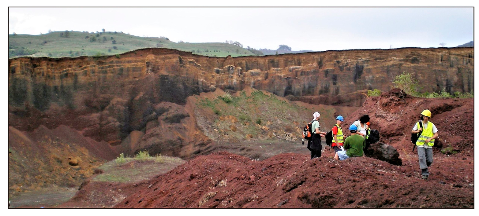
- Givulescu, R. Fossil Flora of Upper Miocene in Chiuzbaia, Maramureş County; Editura Academiei Române: Bucharest, Romania, 1990; p. 236. (In Romanian) [Google Scholar]
- Kovacs, M.; Fülöp, A. Laleaua Alba quarry: A Neogene composite igneous body. In Ore Deposits and Other Classic Localities in the Eastern Carpathians: From Metamorphics to Volcanics; Iancu, O.G., Kovacs, M., Eds.; IMA 2010 Field Trip Guide RO1, Acta Mineralogica-Petrografica; University of Szeged: Szeged, Hungary, 2010; Volume 19, pp. 32–35. [Google Scholar]
- Brocx, M.; Semeniuk, V. Using the Geoheritage Tool-Kit to Identify Inter-related Geological Features at Various Scales for Designating Geoparks: Case Studies from Western Australia. In From Geoheritage to Geoparks. Geoheritage, Geoparks and Geotourism; Errami, E., Brocx, M., Semeniuk, V., Eds.; Springer: Cham, Switzerland, 2015. [Google Scholar] [CrossRef]
- Fülöp, A.; Kovacs, M. Managing the geodiversity in Baia Mare region; from scientific to public interest. Stud. Univ. Babes-Bolyai Geol. 2010, 55, 5–8. [Google Scholar] [CrossRef]
- Kovacs, M.; Fülöp, A. Baia Mare Geological and Mining Park—A potential new Geopark in the northwestern part of Romania. Stud. Univ. Babeş-Bolyai Geol. 2009, 54, 27–32. [Google Scholar] [CrossRef]
- Naum, T.; Butnaru, E.; Giurescu, M. The volcanokarst from the Călimani massif (Eastern Carpathians). An. Univ. Bucureşti Ser. St. Nat. Geol.-Geogr. 1962, 32, 143–179. (In Romanian) [Google Scholar]
- Downes, H.; Seghedi, I.; Szakacs, A.; Dobosi, G.; James, D.; Vaselli, O.; Rigby, I.; Ingram, G.; Rex, D.; Pecskay, Z. Petrology and geochemistry of late Tertiary/Quaternary mafic alkaline volcanism in Romania. Lithos 1995, 35, 65–81. [Google Scholar] [CrossRef]
- Rapprich, V.; Lisec, M.; Fiferna, P.; Zavada, P. Application of Modern Technologies in Popularization of the Czech Volcanic Geoheritage. Geoheritage 2016, 9, 413–420. [Google Scholar] [CrossRef]
- Szepesi, J.; Harangi, S.; Ésik, Z.; Novák, T.J.; Lukács, R.; Soós, I. Volcanic Geoheritage and Geotourism Perspectives in Hungary: A Case of an UNESCO World Heritage Site, Tokaj Wine Region Historic Cultural Landscape, Hungary. Geoheritage 2016, 9, 329–349. [Google Scholar] [CrossRef] [Green Version]
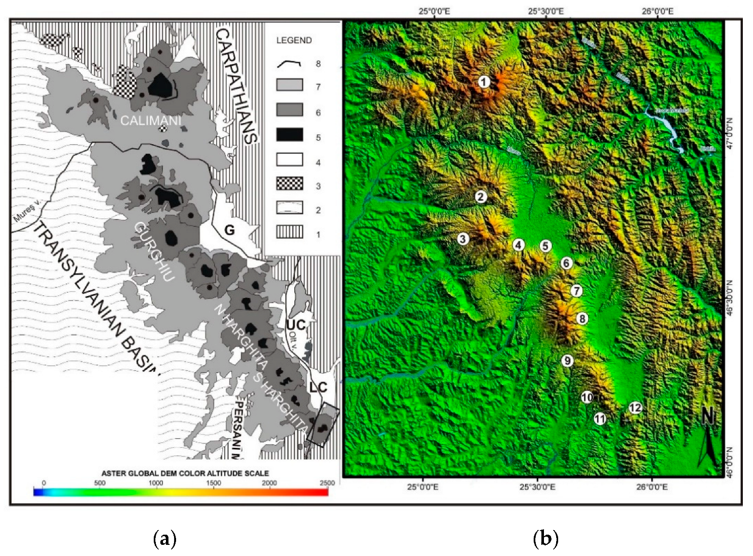


| Volcano (Name, Location and Figure Reference) | Volcanic Forms | Morphometry Aria/Diameter, Elevation a.s.l. | Major Landform Features |
|---|---|---|---|
| Călimani Mountains | |||
| Rusca-Tihu (Figure 7) | Collapsed composite volcano | ~24 × 16 km 1925 m | Strongly eroded, high-mountain, steep-sloped remnants of the upper part of a tall (ca. 3000 m) collapsed composite volcano |
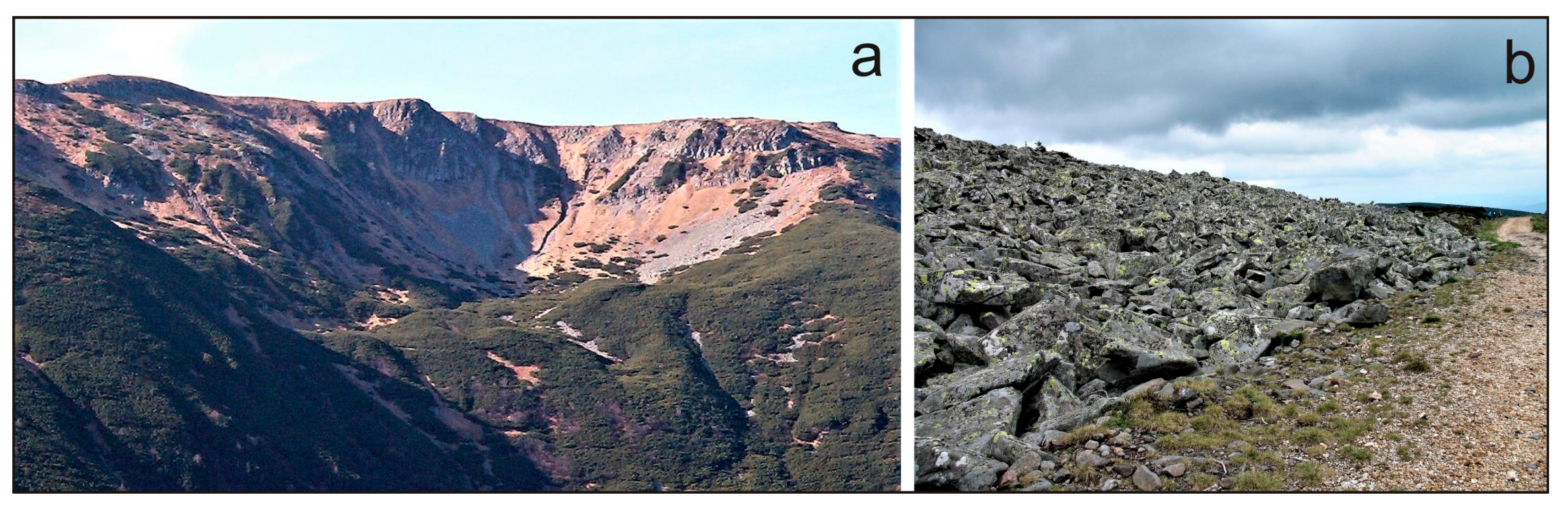
| Călimani caldera (Figure 6) | Andesitic caldera volcano | ~15 km 2102 m | >8 km wide northward-open semicircular depression and gentle outer slopes diverging from its rim to the East and South |
| Sărmaș | Basaltic shield volcano | >3.5 km, 1398 m | Partially buried shield volcano with patchy outcrop areas |
| Gurghiu Mountains | |||
| Jirca | Andesitic composite volcano | >4 km 1480 m | Steep ruin-like remnants of a strongly eroded and partially covered volcanic edifice |
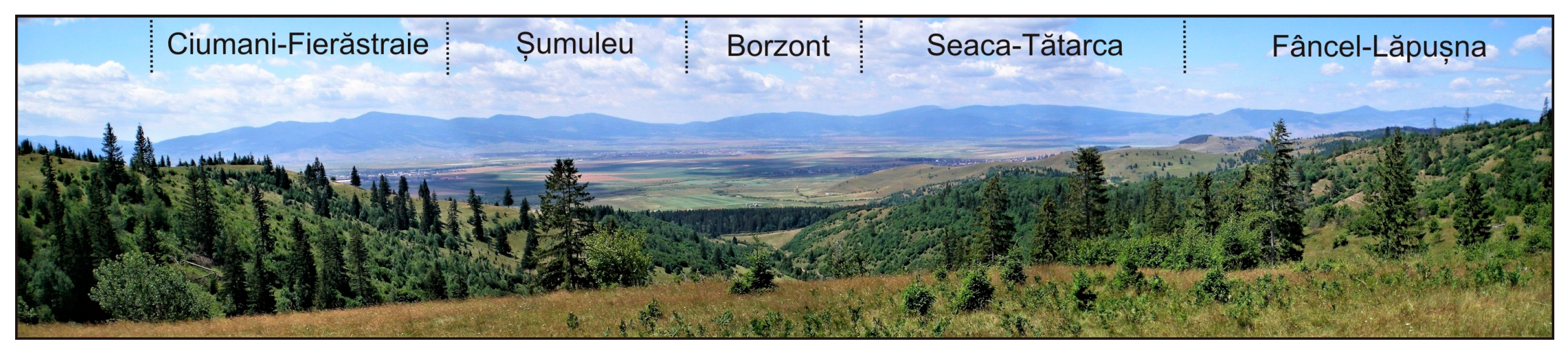
| Fâncel-Lăpușna (Figure 6 and Figure 8) | Andesitic composite volcano with caldera | ~15 × 12 km 1684 m | Southward-open arcuate central despression of a half-caldera and gentle outer slopes to the North and the East; |
| Seaca-Tătarca (Figure 6 and Figure 8) | Shield-like andesitic volcano | ~16 × 9 km, 1776 m | Upward-convex mountain with a large northward-open almost intact central crater depression with a centripetal hydrographic catchment area |
| Șumuleu (4 in Figure 6 and Figure 8) | Andesitic composite volcano | ~12 × 6 km, 1576 m | Eastward-open central crater depression with centripetal hydrographic catchment area and gentle outer slopes |
| Borzont (Figure 8) | Andesitic lava dome | 5 × 3.5 km | Upward-convex mountain with no central depression on top |
| Ciumani-Fierăstraie (Figure 6 and Figure 8) | Andesitic composite volcano | ~9 × 6 km, 1694 m | Steep summit with two craters (opened to North and South, respectively) and moderate outer slopes |
| North Harghita Mountains | |||
| Răchitiș (Figure 9) | Aphanitic-andesite lava dome | 3 km 1155 m | Isolated, cone-shaped mountain |
| Ostoroș (Figure 6 and Figure 9) | Andesitic composite volcano | ~8 km 1384 m | Eastward-open central crater depression with centripetal hydrographic catchment area and gentle outer slopes |
| Ivo-Cocoizaș (Figure 6 and Figure 9) | Shield-like andesitic composite volcano | ~11 × 8 km 1589 m | A large, semicircular summit depression opened to the South and drained by a bilaterally-divergent, hydrographic catchment area; gentle outer slopes |
| Vârghiș (Figure 6 and Figure 9) | Collapsed andesitic composite volcano | ~18 km 1801 m | Southward-open, large, arcuate central depression bordered by 4 summit highs and gentle outer slopes; a second crater depression (Harghita-Băi) in the southern-eastern lower part |
| Șumuleu-Ciuc | Dacitic dome | 2.5 km 1033 m | Roughly cone-shaped isolated mountain |
| South Harghita Mountains | |||
| Luci-Lazu (Figure 6 and Figure 10a) | Andesitic shield volcano | ~15 × 12 km 1293 m | Low-angle, upward-convex mountain with a pit-bog hosting summit crater |
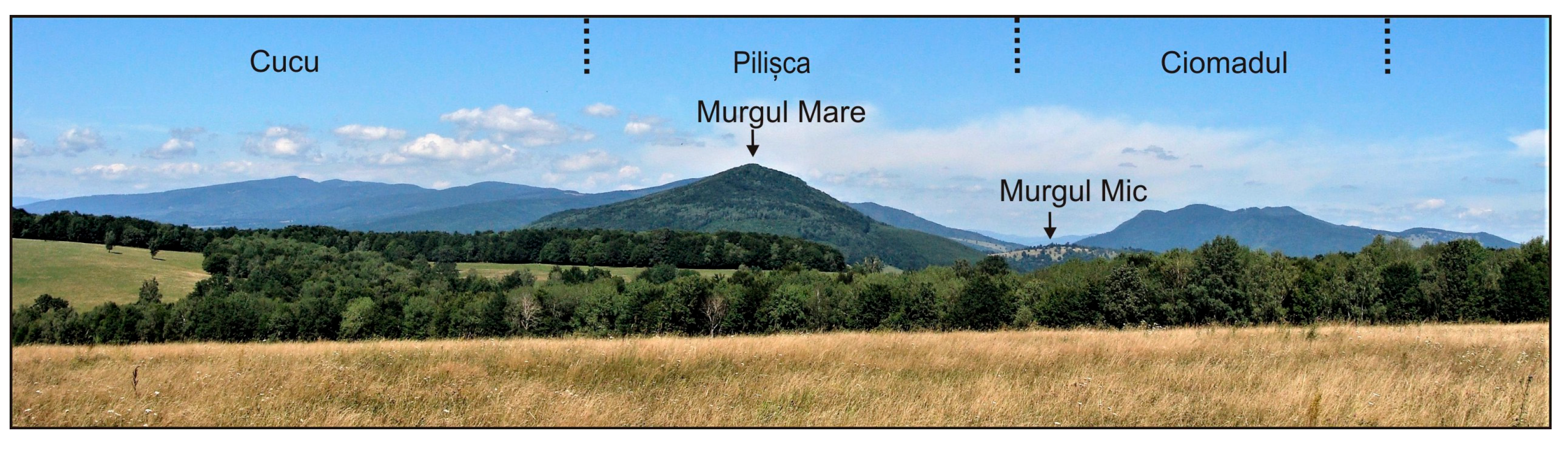
| Cucu (Figure 6, Figure 10b and Figure 11) | Domes-topped andesitic-dacitic composite volcano | ~10 × 8 km 1558 m | Summit area with multiple craters opened in a paralellipipede-shaped common depression opened to SE and gentle outer slopes |
| Pilișca (Figure 6, Figure 10c and Figure 11) | Dome-topped andesitic-dacitic composite volcano | ~8 km 1374 m | Upward-convex lower half and steep-sloped summit with a strongly eroded, steep crater remnant to the east |
| Ciomadul (Figure 6, Figure 10d and Figure 11) | Dacitic dome cluster with twin craters | 10.5 × 7.5 km 1301 m | Assemblage of central, steep-sloped, tightly packed hills with two summit craters and a few isolated peripheral hills |
| Murgul Mare (Figure 11) | Dacitic lava dome | 2.4 km 1016 m | Cone-shaped isolated mountain |
| Murgul Mic (Figure 11) and Luget | Two shoshonitic lava domes | 2.7 × 2.3 and 2.2 × 1.8 km 821 m | Flat-topped hills partially removed by heavy quarrying in their eastern halves |
| Geosite | Major Geoheritage Features | Significance | Scale (Size) | IUCN Category |
|---|---|---|---|---|
| Oaș–Gutâi Mountains | ||||
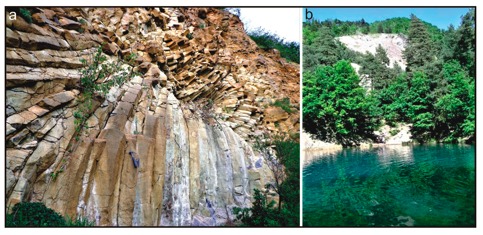
| Ilba “Stone Rosette” (Gutâi Mountains, Figure 22a) | Impressive, radial columnar-jointing of lava dome andesite, unique in the East Carpathians; included in scientific and educational field trips | Local | Small scale (0.5 ha) | III |
| Limpedea Pillars (Gutâi Mountains) | Vertical columnar-jointing of andesite in an old quarry, a touristic attraction and a traditional rock climbing site | Local | Small scale (3.0 ha) | III |
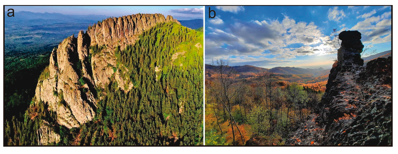
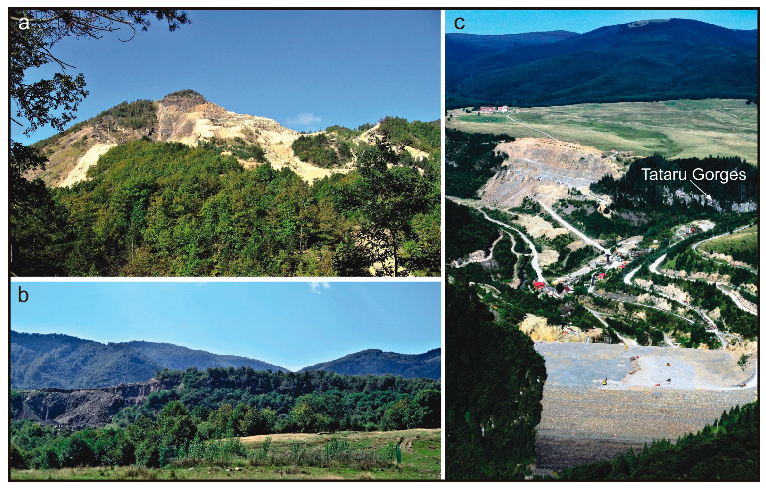
| Tătaru Gorges (Gutâi Mountains, Figure 19c) | Spectacular gorges excavated in massive andesit plateau; a touristic attraction site | Regional | Small scale (15.0 ha) | IV |
| Lacul Albastru (Blue Lake) (Gutâi Mountains, Figure 22b) | Picturesque, mining-related anthropic lake with a changing blue-greenish-colored water imprinted by ore minerals, unique in Europe | National | Small scale (0.5 ha) | III |
| Chiuzbaia Fossiliferous Reserve (Gutâi Mountains) | One of the richest Upper Miocene fossil flora sites in Europe with species described for the first time in the world. Geosite of outstanding scientific value. | International | Mesoscale (50.0 ha) | IV |
| Creasta Cocoşului (Rooster’s Crest) (Gutâi Mountains, Figure 16a) | Impressive, crest-like landform at the edge of an andesite lava dome; a major touristic attraction site included in a very popular geotrail. | National | Mesoscale (50.0 ha) | IV |
| Călimani-Gurghiu-Harghita Mountains | ||||
| Călimani National Park (Figure 7, Figure 17a,b, Figure 18 and Figure 20c) | High-mountain volcanic landscape hosting many geosites of high geoheritage value of geological, geographical, and botanical interest *; a very popular touristic destination, including the Maria Therezia Road | International | Macroscale (15,300 ha) | II |
| “12 Apostles” Science Reserve, Călimani Mountains (Figure 18) ** | Spectacular, tens-of-meters high rock formations sculptured by wind erosion in volcaniclastic breccia; an outstanding geotouristic attraction site | National | Mesoscale (200 ha) | III |
| “Upper Mureș Gorge Natural Park” (Călimani and Gurghiu Mountains divide) | Almost continuous exposures of volcaniclastic rocks of various nature and sources along a picturesque ca. 25 km long valley sector; a picturesque easy-to-reach roadside touristic attraction site combining natural (geologic) and anthropic/cultural values hosting unique tree-mold caves | National | Macroscale (9156 ha) | IV |
| “Scaunul Domnului” (“God’s chair”) Nature reserve (Călimani Mountains) | Fragment of a lava plateau bordered by spectacular vertical cliffs; final destination of a very popular tourist trail offering a breathtaking panoramic view over the Transylvanian Basin | National | Mesoscale (71 ha) | IV |
| Toplița thermal water fall Natural reserve (Gurghiu Mountains) | Active deposition of calcareous tufa from thermal water on a steep vegetation-covered cliff facing the Mureș valley; a touristic attraction site near a thermal water spa area | Local | Small scale (0.5 ha) | III |
| “Dealul Melcului” (“Snail Hill”) Natural reserve (Corund, Gurghiu Mountains) | Three prominent mounds formed on thick veins of fracture filling aragonite covered by surface-deposited calcareous tufa; ongoing carbonate deposition from salty mineral water; remnants of historical aragonite extraction; geosite of scientific interest combined with cultural heritage (“Aragonite Museum” nearby) and a touristic attraction site | Local | Small scale (8 ha) | III |
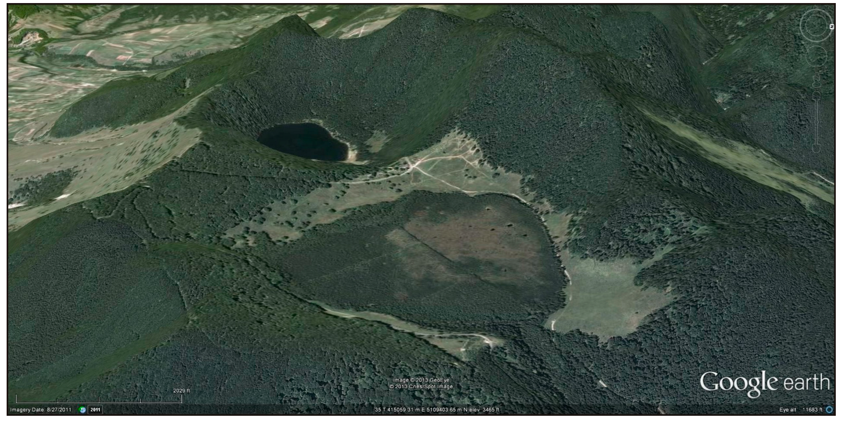
| Tinovul Mohoș-Lacul Sfânta Ana Natura 2000 site (Harghita Mountains, Figure 25) | Two picturesque craters of Ciomadul volcano hosting a peatbog (Mohoș) and a lake (Sfânta Ana), respectively, unique in Eastern Europe; one of the most popular touristic destinations in Romania; outstanding scientific value | International | Mesoscale (240 ha) | IV |
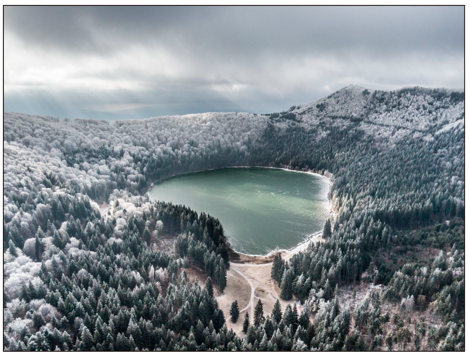
| Sfânta Ana Lake protected area (Harghita Mountains, Figure 26) *** | A spectacular lake at the bottom of one of the Ciomadul volcano craters in a completely closed depression, unique in Eastern Europe and of outstanding scientific and geotouristic value | International | Mesoscale (120 ha) | IV |
| Piatra Șoimilor (“Eagle Rock”) Natural reserve (South Harghita Mountains) | Spectacular vertical rock cliff in andesitic clastic lava of Pilișca volcano; final destination of a steep tourist trail; panoramic view point over the Ciomadul volcano dome complex and the Băile Tușnad spa below | Local | Small scale (1.5 ha) | IV |
| Perșani Mountains | ||||
| “Sculptured stone” basaltic columns (Comana) | Vertical columnar jointing of alkali basalts; difficult-to-find geosite of scientific value hidden in forrest | Local | Small scale (1 ha) | III |
| Racoșul de Jos Natural reserve (Figure 21 and Figure 27) | Various features of alkali basaltic volcanism: variously jointed lavas, phreatomagmatic deposits, and an eviscerated scoria cone exposing the internal structure of a small volcano; geosite of outstanding scientific value and of touristic attraction | National | Mesoscale (95 ha) | IV |
| “Racoș basalt columns” Natural monument **** | Spectacular vertical wall of columnar jointed alkali basalt lavas; one of the earliest protected geosites in Romania of great scientific value; also a touristic attraction site. | Local | Small scale (1.1 ha) | III |
| “Basaltic micro-canyon” of Hoghiz | Deep and narrow canyon with vertical walls exposing alkali basaltic lavas and a calcareous tufa mound on top; easy-to-reach geosite of scientific value | Local | Small scale (2 ha) | III |
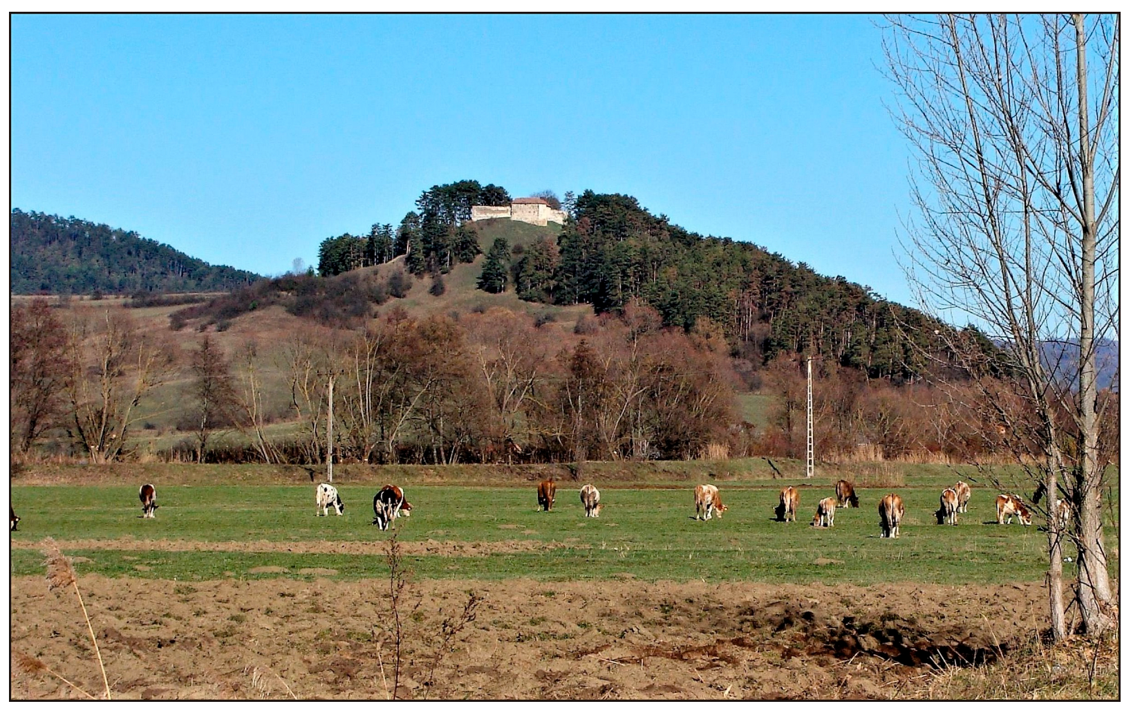
| “Basaltic Rock of Rupea” natural monument (Figure 28) | Prominent isolated hill of basaltic andesite rising above Rupea town, with a medieval castle on top; unique site combining geological, cultural, and historical values; also a touristic attraction and a panoramic viewpoint over the surrounding landsacape and the Saxon-inhabited town below | National | Small scale (9 ha) | III |
Publisher’s Note: MDPI stays neutral with regard to jurisdictional claims in published maps and institutional affiliations. |
© 2022 by the authors. Licensee MDPI, Basel, Switzerland. This article is an open access article distributed under the terms and conditions of the Creative Commons Attribution (CC BY) license (https://creativecommons.org/licenses/by/4.0/).
Share and Cite
Szakács, A.; Kovacs, M. Volcanic Landforms and Landscapes of the East Carpathians (Romania) and Their Geoheritage Values. Land 2022, 11, 1064. https://doi.org/10.3390/land11071064
Szakács A, Kovacs M. Volcanic Landforms and Landscapes of the East Carpathians (Romania) and Their Geoheritage Values. Land. 2022; 11(7):1064. https://doi.org/10.3390/land11071064
Chicago/Turabian StyleSzakács, Alexandru, and Marinel Kovacs. 2022. "Volcanic Landforms and Landscapes of the East Carpathians (Romania) and Their Geoheritage Values" Land 11, no. 7: 1064. https://doi.org/10.3390/land11071064
APA StyleSzakács, A., & Kovacs, M. (2022). Volcanic Landforms and Landscapes of the East Carpathians (Romania) and Their Geoheritage Values. Land, 11(7), 1064. https://doi.org/10.3390/land11071064