Abstract
The purpose of this work was the conceptual elaboration of a proposed zoning based on the concepts of recovery, rehabilitation, and restoration, for the Ipojuca watershed, located in the state of Pernambuco, in the north-eastern region of Brazil. It also sought to bring together a set of technical and normative instruments capable of being articulated in environmental policies that have river restoration as the main exponent of ecological and sustainability criteria. Data from the MapBiomas project, which aims to map the annual land cover and use in Brazil, and rainfall data from the stations located in the study area, were used as a basis for the zoning. From the combination of these databases, three sectors with similar characteristics were established, which served as the basis for the zoning. The overlap shown in these data confirmed the influence of the rainfall pattern on the characteristics of the land cover and pattern of use in each sector, where agricultural activities and urbanisation have played a decisive role in the degradation of water bodies and their bordering environments along the watershed.
1. Introduction
The watershed as a unit of geographical analysis is the product of complex social relationships based on multiple dimensions, which can be political, economic, cultural, spatial, or ecological [1]. It features a social construction derived from historical practices shaped by the society that inhabits it, through its most diverse functions. This social construction is subject to power relations and, therefore, must be referenced to formal norms, rules and instances [2].
In this context, land use planning activities are fundamental to the evolutionary process of this very society [3], legislating and regulating the changes to the land system’s components. Changes that can be followed, for example, by land cover and use, circulation, production, and consumption, in addition to the relationships with which people, institutions, and agents structure and appropriate the geographical space [4].
As a result of this process, there are several impacts on the environment, in the physical and biotic realms, which in the case of a watershed have different dynamics due to their location and interaction with other landscape elements [5,6]. There are a series of negative effects that are cumulative, such as deforestation, which is responsible for soil erosion processes and their impacts on surface and underground water bodies [7,8].
The loss of quality and quantity of the water resource and the degradation of areas bordering the rivers, which are essential for their conservation, have been the target of investigative and propositional work [9,10]. Due to the historical importance of rivers in social organisation and as a means of sustaining life in general, their environmental conservation is an essential condition for the maintenance of a socio-ecological system that aims to be balanced and sustainable [11,12].
This environmental conservation can occur at several levels, with environmental or ecological restoration considered as the most advanced of the management processes of a natural system that has already been degraded [13]. Other terms are also used to describe or frame the level of interventions and their objectives, aimed at improving quality in degraded environments, such as revitalisation or renaturalisation [14,15].
In the scope of this work, the objective was the conceptual elaboration of the propositional zoning based on a hierarchy of the necessary and possible levels of intervention for improvement of the environmental quality of the Ipojuca River; a key river located in the northeast region of Brazil. This river is the setting of a centuries-old agriculture and livestock process originating in colonial Brazil that still marks the landscape, where the characteristics of the physical environment, especially the distribution pattern and the amount of rainfall, played a decisive role in the social and economic development. This was directly reflected in the organisation of the mosaic of activities that make up its landscape.
From the identification of the process of intense degradation of the river, such as the reduction of oxygen in the water, eutrophication, sedimentation, and the loss of biodiversity, mainly caused by agricultural productivism and the urbanisation process on the banks of the Ipojuca River [16], an attempt was made to bring together a set of technical and normative instruments capable of being articulated in environmental policies. As a principle, the concept of restoration was established as the maximum exponent of ecological and sustainability criteria.
For the conceptual zoning model, the concepts of recovery, rehabilitation, and restoration were adopted, which point to a path opposite to that of environmental degradation [17], delimiting the degree of resumption of the river’s environmental conditions in view of the current uses and forms of appropriation. A series of productive practices and activities [18,19], as well as the increasing urbanisation process, caused significant and irreversible changes in most of its course. These changes have always been associated with the process of environmental degradation, resulting from the limited control of land cover and use.
2. Materials and Methods
For the mapping of land cover and use, data from the MapBiomas project were used as a reference, which aims to carry out the annual mapping of land cover and use in Brazil, based on a collaborative network comprised of several specialists in different fields. It covers issues related to Brazilian biomes, land uses, remote sensing, geographic information systems, and information science.
The MapBiomas data are derived from Landsat satellite images with a spatial resolution of 30 metres, processed on the Google Earth Engine platform, using the pixel-by-pixel classification, where a time series between the years 2000 to 2015, with an interval every five years, was considered. To produce images without the interference of clouds or smog, pixels without cloud cover were selected among the landscapes corresponding to the analysed period. For each pixel, metrics corresponding to the year of analysis were extracted, which explain the pixel’s behaviour. This procedure was repeated for each of the satellite’s seven spectral bands (Table 1), as well as for the calculated spectral fractions and indices.

Table 1.
Spectral band specifications—ThematicMapper.
For each period studied, a mosaic of the watershed was created. From the image mosaics, maps of each land cover and use class were produced, considering a total of nine classes: Agriculture or pasture, Pasture, Grassland vegetation (fields), Open forest, Dense forest, Urban infrastructure, Mangrove, Water bodies, and Beaches and dunes.
This process was performed using the automatic Random Forest classifier and executed in a Google Cloud environment. Subsequently, the maps of each class were integrated into a single file representing the land cover and use of the area of interest for each year of the analysis interval. The ArcGIS software version 10.8 was used to convert the raster files to vector format—where the surface areas of each cover/use class were calculated, expressed in hectares and the respective percentages of each class within the watershed, by the period of analysis.
Then, these classes were grouped according to the level of alteration of the natural environment and the impact of its effects on environmental systems. Four standards were defined from the processed data and the field surveys for their validation, as shown in Table 2.
Table 2.
Criteria established for the definition of zones and their different degrees of change.
The arrangements formed by these patterns of occupation and use were later crossed with the precipitation data. The choice of rainfall indicators to define the zoning started from the principle that, historically, in the northeast of Brazil human activities have always been conditioned by the characteristics of the physical elements of the landscape and the pattern of rainfall distribution [20].
Due to this, the demarcation of areas was carried out based on the aggregate of average monthly rainfall data obtained by rainfall stations located in the municipalities that make up the watershed. These data were spatialised and interpolated using the Voronoi Diagram (Thiessen Polygons), as shown in Figure 1, which consists of creating a polygonal mesh around a set of points in a given space, assigning to all locations in that space the corresponding value for the closest point in the point set.
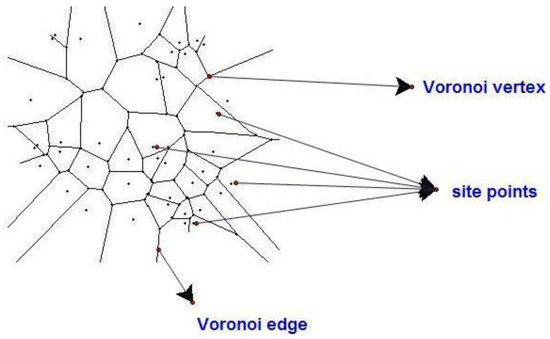
Figure 1.
Voronoi Diagram. Source: KUZLE, Ana.
Subsequently, these areas were grouped via the Natural Breaks (Jenks) method, considering similar values that maximise the differences between the classes, indicated for mapping data values that are not uniformly distributed. From this, three sectors with similar characteristics were defined, originating from the combination between the land cover and use patterns and the rainfall pattern, with these being demarcated in the west-east direction (from upstream to downstream) covering the entire watershed, called Sectors 1, 2, and 3 (S1, S2, and S3).
Based on these principles and considering zoning as the guiding framework for actions aimed at protecting the Ipojuca River, criteria were defined for the conservation of the water resource and the river as a whole, having as a landscape, the conception of an instrument of intervention materialised in the following propositional zoning (Table 3):
Table 3.
Classes proposed for the zoning of the Ipojuca River.
The Z1 and Z2 allow for an adaptation of the interventions to the environmental characteristics and to the uses of the surrounding areas, considering that in many stretches, the river is totally urbanised along its banks, and in other areas, agricultural and pastoral activities have completely changed the morphology and flow of the water, which is also a consequence of abstractions for irrigation. In these cases, the objective is to ensure an improvement in environmental quality and to promote a re-appropriation of the river and its multiple uses by local communities.
In the case of Z3, the proposal of this zone is to try to return the river to a condition very close to the original, taking advantage of the stretches in which the level of change of the landscape has not significantly altered the morphology of the site and is presently dominated by agricultural activities, where the main actions are related to reforestation and restoration of the riparian forest.
3. Results
The average monthly rainfall of the BHRI (Ipojuca River Watershed) can be seen in Figure 2, in which three sectors well demarcated by the rainfall pattern and influenced by the Borborema plateau, are characterised. The eastern escarpment of the Borborema demarcates the eastern wetland of the watershed, with rainfall above 1000 mm/year, and is also known as the Pernambuco Zona da Mata (Forest Area). In the far west of the watershed, between the municipalities of Arcoverde, Sanharó and Chã Grande, the Pernambuco Agreste (Wild) is more strongly characterised. This is demarcated by rainfall below 1000 mm/year. The rains governed by the Southeast winds are more scarce with about 600 mm in annual averages, than in the view of Melo [21], and are compensated by the occurrence of small humid patches of altitude or valleys well oriented in the direction of the winds, called swamps, which are frequent throughout the Agrestina region.
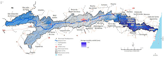
Figure 2.
Average monthly rainfall of the BHRI. Sources: DNIT—highways. IBGE—municipal and state boundaries, and municipal capitals. Government of Pernambuco—Hydroenvironmental Plan— boundary of the Ipojuca River watershed. Prepared by the authors.
The higher the rainfall, the greater the effects on landscape modelling [22]. In the same way, the characteristics of the terrain directly influence the erosive processes acting in the watershed, since the predominant altitudes in the Borborema plateau region cause more abundant rainfall in higher places, leaving the rest of the moisture to precipitate to the west with less intensity [21].
This particular rainfall pattern was pivotal for the determination of productive activities linked to the land (crops and pastures) and for the consolidation of human settlements that evolved over centuries of occupation, currently configuring a key urban network for the State of Pernambuco. This spatial configuration of land cover and use is characterised in Table 4 and Table 5 and in Figure 3 and Figure 4.
Table 4.
Characteristics of land cover and use of the Ipojuca River watershed, PE, from 2000 to 2015.
Table 5.
Land cover and use by class and by degree of change, 2015.
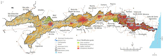
Figure 3.
Spatialisation of zones considering the different degrees of change in the BHRI in 2015. Sources: DNIT—highways. IBGE –municipal and state boundaries, and municipal capitals. Government of Pernambuco—Hydroenvironmental Plan and boundaries of the Ipojuca River watershed. NASA, Shuttle Radar Topography Mission (SRTM)—terrain.
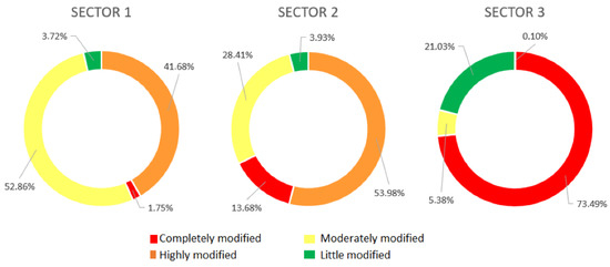
Figure 4.
Degree of change by sector in the BHRI in 2015. Source: Adapted from Oliveira, 2021.
The overlapping of these two sets of data confirmed the influence of the rainfall pattern on the characteristics of the land cover and use pattern in each sector, where urbanisation and agricultural activities have played a decisive role in the degradation of water bodies and their bordering environments throughout the watershed, especially in relation to its main course, the Ipojuca River. Thus, each of the sectors has a dominant characteristic, as described below:
- S1—West sector of the watershed. Even under human pressure, the moderately changed environments are dominant (86,392.23 ha), as they still preserve a significant percentage of forest remnants, with the landscape being characterised by the predominance of fields (10,584.95 ha) and open forest (75,204.96 ha), resulting in partially preserved environments, as well as areas in different stages of the recovery process. In this sector, the main impacts on the Ipojuca River resulting from human activities are pastures and subsistence agriculture;
- S2—Located in the central portion of the watershed. It is the most urbanised sector, with the city of Caruaru being a key regional centre, the second most populated city in the State of Pernambuco, and the third most populated in the north-eastern interior. There is a large area dedicated to pastures (34,755.25 ha) and agriculture is carried out only along the main course of the Ipojuca. It is the sector of the watershed with the lowest rainfall;
- S3—East sector of the watershed, where the mouth of the Ipojuca is located. As it is the most humid sector, it has a predominance of agricultural activities, especially the cultivation of sugarcane, in addition to fruits and vegetables, to a lesser extent. In the estuary, there are well-preserved mangroves, classified as an Area of Permanent Preservation. Next to them is the Suape Port Industrial Complex, comprising more than 100 companies. It is the watershed sector with the highest percentage of slightly changed environments.
Considering the characteristics of each of the sectors described above, the current levels of anthropisation and degradation throughout the watershed and the limitations imposed by its historical occupation process, it is proposed to apply the following conceptual zoning scheme, aimed at improving the environmental quality of the Ipojuca River (Figure 5). The width of the buffer varies between 50 m (sections between 10 and 50 m wide) and 100 m (sections between 50 and 200 m wide), according to Brazilian legislation.
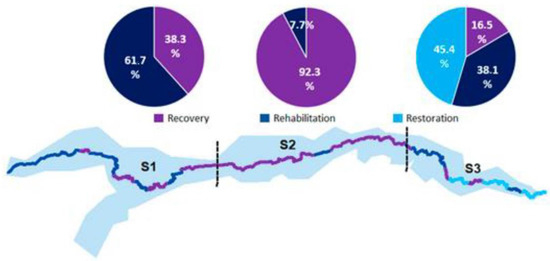
Figure 5.
Propositional zoning for the Ipojuca River with a view to improving the environmental quality.
4. Discussion
Oliveira [16] addresses the consensus of various researchers that zoning is considered the starting point of a land-use planning process. Its main function is aimed at prioritising investments and introducing intervention measures, such as the recovery of degraded areas and the introduction of physical infrastructures like sewage networks, public lighting, and environmental control.
In the context of land-use planning: zoning is an instrument of state intervention that aims to organise the spatial production relations, encouraging or repressing behaviours [23], which involves decisions or choices about alternative ways of using the available resources [24,25,26] with the objective of reaching specific goals in the future, in order to achieve the proposed development objectives incorporating the environmental component.
As one of the instruments of the National Environmental Policy in Brazil, environmental zoning has the essential aim of organising and regulating the decisions of public and private agents that involve natural resources, ensuring the free movement of activities and respecting the characteristics of the environment in which they take place. Ab’Saber [27] emphasises that the concept of zoning requires a series of prior understandings; its application or use, regarding a certain geographical space, requires method, reflection, and its own strategies.
In the case of the Ipojuca River, the analysis of land cover and use data has shown that human interference in environmental systems over the years has caused serious negative impacts on the watershed, significantly compromising the river. The results presented herein show a worrying reality, as the environmental problems resulting from the intensive use, inadequate management, and, principally, the discrepancy between land suitability and use, have been aggravated by the loss of native vegetation cover.
In Sector 1, the sudden change in morphological, climatic, and phytogeographical features and in the forms of land cover and use is evident, especially when compared to Sector 3. As highlighted by Melo [21], in Sector 1, the low slope of the wetland hills is not noticeable. There is a bristling, stony terrain and often steep slopes, cut off by intermittent rivers, with large, rocky outcrops, resulting from the high climatic contrasts, with subsistence agriculture, livestock, and sheep and goat farming abundant in the region (Figure 6).
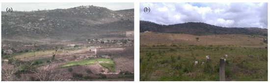
Figure 6.
(a,b): Bristling, stony terrain and steep slopes, as well as the presence of livestock, predominant in two images of the Sector 1. Source: Field survey, 2018.
In Sector 2, the natural landscape underwent major transformations with the gradual replacement of native vegetation cover to make way for agricultural crops, livestock, and sheep and goat farming, as well as the growth of cities. A striking characteristic of this sector is the increasingly degraded, heterogeneous, and fragmented environments due to urbanisation. Due to the low levels of rainfall, there is a large presence of intermittent rivers in this sector, which leads to a concentration of agriculture on the banks and bordering areas of the Ipojuca (Figure 7).
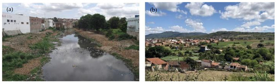
Figure 7.
(a,b): Stretch of the river degraded by urbanisation and agriculture focused on small commerce and personal consumption—Sector 2. Source: Field survey, 2018.
In Sector 3, the data showed that this landscape unit is rather transformed by socio-productive activities, where most of it has considerable human interference. However, it is possible to find fragments of open and grassland vegetation in the midst of sugarcane plantations. The hilly terrain characterises the landscape of seas of hills, offering dry lands on the gentle slopes or hillsides and wetlands on the floodplains [21]. Due to the preservation of the morphology in stretches of the river, some areas are still conducive to the establishment of restoration processes (Figure 8).
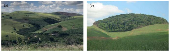
Figure 8.
(a,b): Presence of fragments of vegetation in the midst of sugarcane crops—Sector 3. Source: Field survey, 2018.
Based on the characterisation of these three sectors, Table 6 presents actions to be implemented in the intervention zones of each of them. These actions are organised according to the identification of the different processes of anthropisation and the possibilities of realisation, considering the context studied.
Table 6.
Proposals of management actions/activities to be taken into account when designing land-use plans for the BHRI by Sector and Zone.
Urban areas were responsible for the greatest impacts on the river morphology of the watershed, especially due to their growth in the last quarter of the 20th century [21] (MELO, 2012). Even with legislation at the federal level that includes the protection of water bodies since 1934 and, which, has evolved [28,29,30], the responsibility for controlling land cover and use is an attribution of the municipalities. In this respect, there is an institutional, legal, and technical shortcoming, especially in the interior of Brazilian states [31].
Indication of the improvement of the legal framework by the municipalities, which make up the BHRI, through the updating or preparation of the Sanitation and Urban Development Plans, aims to ensure the institutional guarantees necessary for the intervention measures. They pave the way for resuming the idea of the river as an instrument of development [32,33].
In many cities around the world, a series of measures have been taken to return the rivers to the people [34]. These include the removal of the channelization cover (buffering) and its renaturalisation, with a view to establishing ecological infrastructures that improve the resilience of cities to extreme weather events [19] and provide for the creation of spaces of leisure and coexistence for the population. In the case of the semi-arid region, where water availability is always a concerning factor, the improvement of the river’s sanitation conditions even paves the way for a nobler use of its waters.
In this regard, there is a need to extend the intervention measures beyond urban spaces, considering different spheres of implementation based on the preparation of a Water Resources Plan for the BHRI, comprising the diagnosis and the actions to be carried out for the management, recovery, and preservation of the river. Among the main problems to be faced are the control of erosive processes and water use.
In most of Sectors 1 and 2, the native vegetation was replaced by herbaceous pastures or short-cycle crops, which are different in size to the original vegetation of the caatinga (xerophilous plant formations consisting of thorny shrubs and cacti), making the soil more exposed, causing a loss of fertility, and favouring erosion processes resulting from runoff [35], where the recurrence causes the opening of ravines and gullies, mainly caused by the effect of rainfall. As a result, there is the development of landslides of terraces and sandbanks in the course of the river [36].
In addition, the livestock system generates several environmental impacts that cause environmental degradation which are difficult to reverse. Overgrazing causes excessive treading, which significantly alters the structure of the superficial layer of the soil by intensifying its compactness and diminishing the vegetation cover that, in turn, favours the erosion process and affects the replenishment of freshwater, reducing its infiltration into the water tables [37,38,39,40].
In the case of Sector 3, the planting of sugarcane requires extensive areas of cultivation and the consequent suppression of the original vegetation cover, which reduces soil fertility and protection against erosion. The excessive use of pesticides and fertilisers causes contamination of soils and the river, as they are used without any technical guidance throughout much of the watershed, especially on small properties.
In general, agricultural practices are not at an adequate technological level to make these activities compatible with the protection of ecosystems, which is a more relevant factor when considering the caatinga biome with its poor water availability. As a result, soils are more susceptible to external variables, with emphasis on the processes of leaching, landslides, and gully development [41,42].
The institutional resolution of issues involving land cover and use along the BHRI and the introduction of techniques and technologies focused on reducing the impacts precede or parallel more specific actions, such as the creation of protected natural areas and reforestation. They have a direct impact on the protection of water bodies [43] (RIGOTTI et al., 2017), because in the current context there is no way to improve the environmental condition without first attacking the source of the problems. This also implies the creation of areas of restricted use for the stretches of the river where restoration goals are defined.
In itself, introduction of a restoration target entails questions about which baseline should be used to establish the condition prior to disturbance caused by human occupation. Another relevant issue refers to the comparisons to be made between the recovered areas and other reference areas, points that are still open and need to be answered.
Another point is the dimension of the river restoration process; not only issues related to native species, morphology, hydrological regime, or water quality are involved [44]. It is necessary to integrate the river with the people and, consequently, with the different communities and social groups in a sustainable way and within the limits of the restoration process itself, so that there is a feeling of ownership or belonging, and a bond between people and the river.
5. Conclusions
Due to its territorial reach, the Ipojuca River watershed presents a complex environment, covering in its western part the wild region, with semi-arid climatic characteristics, and passing through the Pernambuco Zona da Mata and coast, with high humidity. Climatic, terrain, soil, and vegetation cover contrasts are evident, as well as socioeconomic ones. These differences require a water and environmental management model that meets the sub-regional and local peculiarities, thus constituting a challenge from the point of view of management and land-use planning.
The complexity of the degradation processes that have occurred in the watershed over the years represents a great challenge in the search for understanding and implementing appropriate mechanisms to solve the existing problems. This is due to the dimension involved in the environmental studies, considering that the phenomena and variables addressed do not occur in isolation. In most cases, there is not a very precise line that separates the boundary between the various physical, biotic and human arrangements that make up each of the sectors defined for the watershed.
Despite their recognised importance [45,46], there is still a lack of coordination between the instruments for managing water resources and those for land cover and use planning. This context shows a delegitimisation of the planning and current legislation, predominantly characterised by informality and illegality in the land cover [47] in both urban and rural environments.
It is important to highlight that the actions aimed at improving the environmental quality proposed for the Sectors and their respective Zones had the purpose of repairing the degraded environment. The evolution of this process is a possible stability of the environment and the restoration of its ecological and social functions, in whole or in part, with the maximum exponent being the state of restoration of the river.
The implementation of programmes and projects for the restoration of the Ipojuca River would, in a way, mean a complete paradigm shift in relation to the way in which society appropriates the watershed. For the small producer in the semi-arid region (subsistence activity) there is currently a lack of resources and means to improve productivity and reduce impacts on the environment. For the large sugarcane producer on the coast, maximising profits drives the expansion of cultivated lands to the limit of the current legislation.
In view of this diverse scenario, the role of the State and the articulations in the political and economic spheres are fundamental for the introduction of measures aimed at improving the environmental conditions of the river. In the real world, they would obviously start with simpler and perhaps experimental solutions, aiming at results that foster trust in the various social agents. This is a necessary issue for the advancement of more complex actions that often require some kind of concession on the part of the productive sector, in exchange for greater future gains.
Lastly, the environmental restoration of the Ipojuca River can be considered as a theoretical concept necessary for the establishment of a planning and evolution landscape for the land-use planning of the watershed. The recovery of the integrity of water bodies would mean greater resilience in the ecological and social context. This would also make the territory less vulnerable to extreme weather events, guaranteeing an indispensable resource (water) for the local productive activities. These actions would open space for a re-engagement between society and nature, within a change of mentality needed to materialise the principles of sustainability.
Author Contributions
Conceptualization, supervision, project afministration, funding acquisition: R.C.L.G.; Methology, Software, Validation, writing-review and editing, visualization: R.A.S.M.; Formal analysis, Investigation, Ressources, Data Curation, writting-original draft: A.G.O. All authors have read and agreed to the published version of the manuscript.
Funding
This Research profit the Competitive Researchs Fund ANTE (Territorial Analysis) Group from Xunta de Galicia.
Data Availability Statement
Not applicable.
Conflicts of Interest
The authors declare no conflict of interest.
References
- Hildén, M. The Role of Integrating Concepts in Watershed Rehabilitation. Ecosyst. Health 2000, 6, 39–50. [Google Scholar] [CrossRef]
- Silva, J.S. Desenvolvimento Territorial e Gestão de Bacia Hidrográfica: O Caso da Bacia do rio Jaboatão, Pernambuco. Master’s Dissertation, Postgraduate Programme in Geography, CFCH. Federal University of Pernambuco, Recife, Brazil, 2013. [Google Scholar]
- Condesso, F.R.C. O Ordenamento do Território; ISCSP: Lisboa, Portugal, 2004. [Google Scholar]
- Nunes, J. Geographic Space as a Set of Concrete Geographical Entities. In Cognitive and Linguistic Aspects of Geographic Space; NATO ASI Series (Series D: Behavioural and Social Sciences); Mark, D.M., Frank, A.U., Eds.; Springer: Dordrecht, The Netherlands, 1991; Volume 63. [Google Scholar] [CrossRef]
- Gülbahar, N.; Elhatip, H. Estimation of environmental impacts on the water quality of the Tahtalıdam watershed in İzmir, Turkey. Environ. Geol. 2005, 47, 725–728. [Google Scholar] [CrossRef]
- Desta, H.; Fetene, A. Land-use and land-cover change in Lake Ziway watershed of the Ethiopian Central Rift Valley Region and its environmental impacts. Land Use Policy 2020, 96, 104682. [Google Scholar] [CrossRef]
- Cunha, A.P.; Alvalá, R.C.; Oliveira, G.S. Impactos das mudanças de cobertura vegetal nos processos de superfície na região semiárida do Brasil. Rev. Bras. Meteorol. 2013, 28, 139–152. [Google Scholar] [CrossRef]
- Rossi, R. Desertification and Agriculture. EPRS—European Parliamentary Research Service, February 2020. Available online: https://www.europarl.europa.eu/RegData/etudes/BRIE/2020/646171/EPRS_BRI(2020)646171_EN.pdf (accessed on 21 November 2021).
- Myers, N. Environmental Degradation and Some Economic Consequences in the Philippines. Environ. Conserv. 1988, 15, 205–214. [Google Scholar] [CrossRef]
- Molle, F.; Wester, P.; Hirsch, P. River basin closure: Processes, implications and responses. Agric. Water Manag. 2010, 97, 569–577. [Google Scholar] [CrossRef]
- Pahl-Wostl, C. The Importance of Social Learning in Restoring the Multifunctionality of Rivers and Floodplains. Ecol. Soc. 2006, 14. Available online: http://www.ecologyandsociety.org/vol11/iss1/art10/ (accessed on 21 November 2021). [CrossRef]
- Hu, M.; Wang, Y.; Xia, B.; Jiao, M.; Huang, G. How to balance ecosystem services and economic benefits?—A case study in the Pearl River Delta, China. J. Environ. Manag. 2020, 271, 110917. [Google Scholar] [CrossRef] [PubMed]
- Ojeda, A.O. Guía Metodológica sobre Buenas Prácticas en Restauración Fluvial; Manual Para Gestores; University of Zaragoza: Zaragoza, Spain, 2015. [Google Scholar]
- Lüderitz, V.; Jüpner, R.; Müller, S.; Feld, C.K. Renaturalization of streams and rivers—The special importance of integrated ecological methods in measurement of success. An example from Saxony-Anhalt (Germany). Limnologica 2004, 34, 249–263. [Google Scholar] [CrossRef] [Green Version]
- Paweł, Ł.; Małgorzata, W.; Ewa, J.; Małgorzata, D. Application of the Unified Stream Assessment Method to Determine the Direction of Revitalization of Heavily Transformed Urban Rivers. Water Resour. 2020, 47, 521–529. [Google Scholar] [CrossRef]
- Oliveira, A.G. Mapeamento e Avaliação da Fragilidade Ambiental em Bacias Hidrográficas Utilizando Álgebras de Mapas com Vistas à Gestão do Território. Ph.D. Thesis, International PhD School (EDIUS), University of Santiago de Compostela, Santiago de Compostela, Spain, 2021. [Google Scholar]
- Alho, C.J.R.; Lacher, T.E.; Gonçalves, H.C. Environmental Degradation in the Pantanal Ecosystem. BioScience 1988, 38, 164–171. [Google Scholar] [CrossRef]
- Warner, R.F. Impacts of environmental degradation on rivers, with some examples from the Hawkesbury-Nepean system. Aust. Geogr. 1991, 22, 1–13. [Google Scholar] [CrossRef]
- Machado, R.A.S.; Lima, E.C.; Oliveira, A.G. Evolução da cobertura e uso do solo na Zona de Amortecimento da Estação Ecológica Raso da Catarina entre 1985 e 2015 e sua relação com o processo de desertificação. Braz. Appl. Sci. Rev. 2020, 4, 3107–3122. [Google Scholar] [CrossRef]
- Filho, H.M.; Moraes, C.; Bennati, P.; Rodrigues, R.A.; Guilles, M.; Rocha, P.; Lima, A.; Vasconcelos, I. Mudança do Clima e os Impactos na Agricultura Familiar no Norte e Nordeste do Brasil; International Policy Centre for Inclusive Growth (IPC-IG), United Nations Development Programme: Brasilia, Brazil, 2016. [Google Scholar]
- Melo, M.L. Paisagens do Nordeste em Pernambuco e Paraíba, 2nd ed.; Revista CEPE.: Recife, Brazil, 2012. [Google Scholar]
- Santana, N.S. Análise da vulnerabilidade ambiental de Salvador: Um subsídio ao planejamento e à gestão territorial da cidade. Ph.D. Thesis, UFBA Geosciences Institute, Salvador, Brazil, 2014. [Google Scholar]
- Antunes, P.B. Direito Ambiental. 12ª. ed Amplamente Reformulada; Editora Lumen Júris: Rio de Janeiro, Brazil, 2009. [Google Scholar]
- Ferreira, F.W. Planejamento sim e não (um Modo de Agir num Mundo em Permanente Mudança), 4th ed.; Paz e Terra: Rio de Janeiro, Brazil, 1983; 157p. [Google Scholar]
- Conyers, D.; Hills, P. An Introduction to Development Planning in the Third World; Public Administration in Developing Countries; John Wiley & Sons: Hoboken, NJ, USA, 1984; 271p. [Google Scholar]
- Santos, R.F. Planejamento Ambiental: Teoria e Prática; Oficina de Textos: São Paulo, Brazil, 2004. [Google Scholar]
- Ab’Saber, A.N. Zoneamento Ecológico da Amazônia: Questões de Escala em Método; Institute for Applied Economic Research; CEPAL/IPEA: Brasília, Brazil, 1987.
- Decrees the Water Code. Brazil. Decree No. 24,643, of 10 July 1934, 1934.
- Sets out the National Environmental Policy, its objectives and mechanisms of formulation and application, and other provisions. Brazil. Law No. 6,938, of 31 August 1981, 1981.
- Institutes the National Water Resources Policy, creates the National Water Resources Management System, regulates section XIX of Art. 21 of the Federal Constitution, and amends Art. 1 of Law No. 8,001, of 13 March 1990, which amended Law No. 7,990, of 28 December 1989. Brazil. Law No. 9,433, of 8 January 1997, 1997.
- Motta, P.R. O estado da arte da gestão pública. Pensata. Rev. Adm. Empres. 2013, 53, 82–90. [Google Scholar] [CrossRef] [Green Version]
- Newson, M. Land, Water and Development. In Sustainable and Adaptive Management of Rivers; Routledge: London, UK, 2008. [Google Scholar]
- Everard, M.; Moggridge, H.L. Rediscovering the value of urban rivers. Urban Ecosyst. 2012, 15, 293–314. [Google Scholar] [CrossRef]
- Wlodarczyk, A.M.; Mascarenhas, J.M.R.D. Nature in cities. Renaturalization of riverbanks in urban areas. Open Eng. 2016, 6, 2016. [Google Scholar] [CrossRef] [Green Version]
- Grilo, D.C.; Franca-Rocha, W.J.S.; Vale, R.M.C. Caracterização Geoambiental associada a processos de desertificação no município de Jeremoabo/Bahia. In Proceedings of the Annals of the 14th Brazilian Symposium on Remote Sensing, Natal, Brazil, 25–30 April 2009; INPE: São José dos Campos, Brazil, 2009; pp. 5243–5249. [Google Scholar]
- Sampaio, E.V.S.B.; Araújo, M.; Dos, S.; Sampaio, Y.S.B. Impactos ambientais da agricultura no processo de desertificação no nordeste do Brasil. Rev. Geogr. 2005, 22, 90–112. [Google Scholar]
- Wüst, C.; Tagliani, N.; Concato, A.C. A pecuária e sua influência impactante ao meio ambiente. In Proceedings of the 6th Brazilian Congress on Environmental Management, Porto Alegre, Brazil, 23–26 November 2015. [Google Scholar]
- De Souza, R.B. Sensoriamento Remoto: Conceitos Fundamentais e Plataformas; IV CEOS WGEduWorkshop: Santa Maria-RS, Brazil, 2010. [Google Scholar]
- Bilotta, G.S.; Brazier, R.E.; Haygarth, P.M. The impacts of grazing animals on the quality of soils, vegetation, and surface waters in intensively managed grasslands. Adv. Agron. 2007, 94, 237–280. [Google Scholar]
- Shukla, P.R.; Skeg, J.; Buendia, E.C.; Masson-Delmotte, V.; Pörtner, H.O.; Roberts, D.C.; Zhai, P.; Slade, R.; Connors, S.; van Diemen, S.; et al. Desertification. In Climate Change and Land: An IPCC Special Report on Climate Change, Desertification, Land Degradation, Sustainable Land Management, Food Security, and Greenhouse Gas Fluxes in Terrestrial Ecosystems; IPCC: Geneva, Switzerland, 2019. [Google Scholar]
- Albiero, D.; Cajado, D.M.; Fernandes, I.L.; Monteiro, L.A.; Esmeraldo, G.G. Tecnologias Agroecológicas para o Semiárido; Edição do Autor: Fortaleza, Brazil, 2015; 216p. [Google Scholar]
- Almeida, A.S.; Santos, R.L.; Chaves, J.M. Mapeamento de Uso e Ocupação do Solo no Município de Jeremoabo-Ba: Uso do Algoritmo Máxima Verossimilhança (Maxver). In Proceedings of the Annals of the 15th Brazilian Symposium on Remote Sensing—SBSR, Curitiba, Brazil, 30 April–5 May 2011; INPE: São José dos Campos, Brazil, 2011; p. 7255. [Google Scholar]
- Rigotti, J.A.; Rodrigues, L.H.R.; Pompêo, C.A.; Pasqualini, J.P. Revitalização de rios: Perspectivas sobre restauração ecológica e desenvolvimento urbano. In Proceedings of the Florianópolis: 22nd Brazilian Symposium on Water Resources, Florianopolis, Brazil, 22–24 September 2017. [Google Scholar]
- Meyer, J.L. Stream health: Incorporating the human dimension to advance stream ecology. J. N. Am. Benthol. Soc. 1997, 16, 439–447. [Google Scholar] [CrossRef] [Green Version]
- Dzurik, A.A. Water Resources Planning; Rowman & Littlefield Publishing Group: Lanham, MD, USA, 2003. [Google Scholar]
- Randolph, J. Environmental Land Use Planning and Management; Island Press: Washington, DC, USA, 2004. [Google Scholar]
- Carneiro, P.R.F. Controle de inundações em bacias metropolitanas, considerando a integração do planejamento do uso do solo à gestão dos recursos hídricos. Estudo de caso: Bacia dos rios Iguaçu/Sarapuí na região metropolitana do Rio de Janeiro. Ph.D. Thesis, Federal University of Rio de Janeiro, Rio de Janeiro, Brazil, 2008. [Google Scholar]
Publisher’s Note: MDPI stays neutral with regard to jurisdictional claims in published maps and institutional affiliations. |
© 2022 by the authors. Licensee MDPI, Basel, Switzerland. This article is an open access article distributed under the terms and conditions of the Creative Commons Attribution (CC BY) license (https://creativecommons.org/licenses/by/4.0/).