
Prioritizing Transboundary Aquifers in the Arizona–Sonora Region: A Multicriteria Approach for Groundwater Assessment


Abstract
1. Introduction
2. Materials and Methods
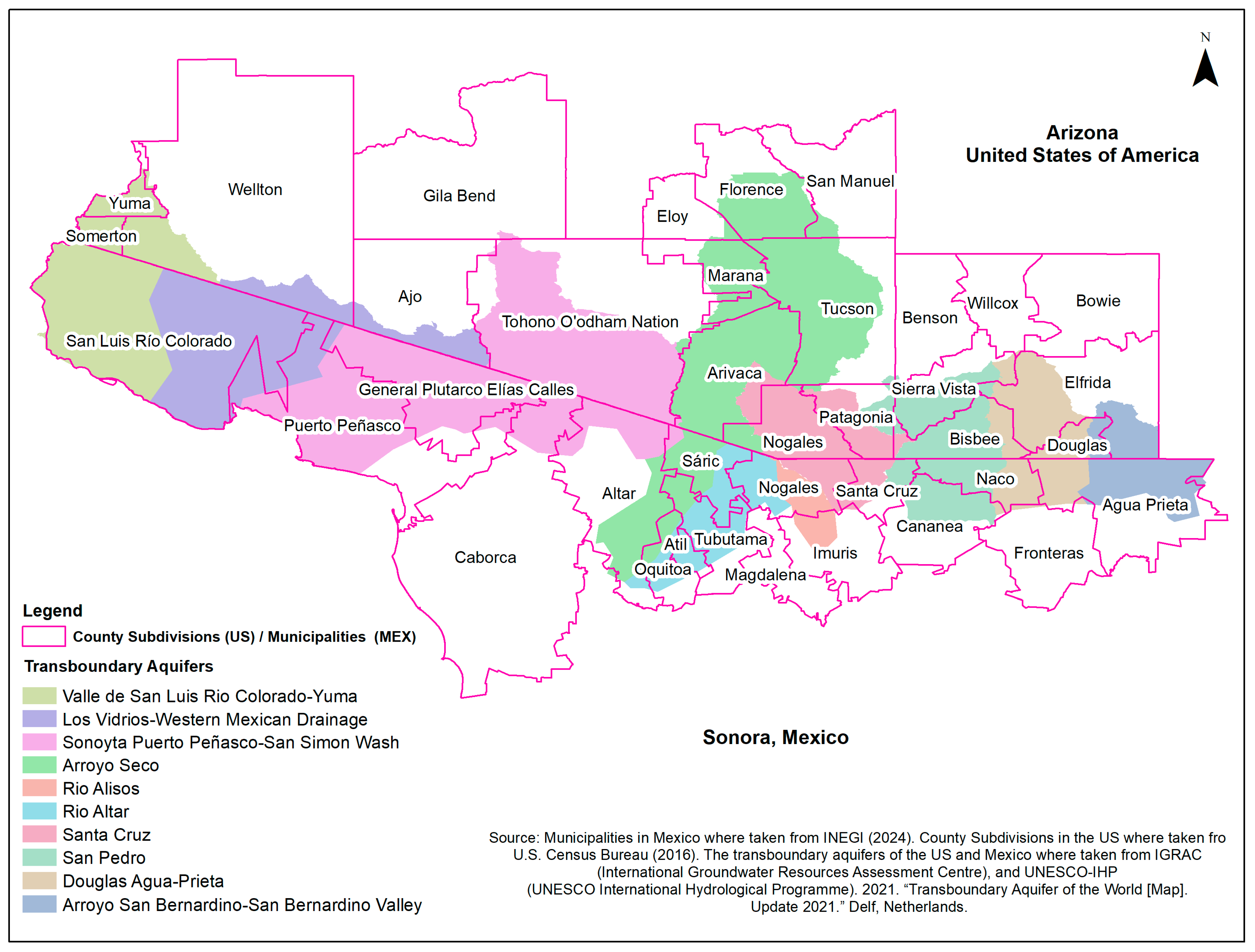
2.1. Study Area
- Valle de San Luis Río Colorado–Yuma Aquifer: Spanning 6403.59 km2 (2472.44 mi2), this aquifer supports a population of 383,860 across Yuma, Somerton, San Luis Río Colorado, and Wellton [26,27]. Yuma plays a critical role in the U.S. agricultural sector, producing a significant portion of the nation’s lettuce, while San Luis Río Colorado is known for its wheat and cotton production [28,29]. Although information about this aquifer is provided for context, it is excluded from the multiple-criteria evaluation due to TAA-Act restrictions on its assessment.
- Los Vidrios–Western Mexican Drainage Aquifer: Covering 7189.21 km2 (2775.77 mi2), this sparsely populated aquifer partially encompasses the municipalities of Puerto Peñasco and Ajo, with a total population of only 53 inhabitants [26,27] (INEGI, 2020). The aquifer’s primary community, Lukeville, Arizona, has 35 residents and serves as a transit point for travelers heading to Puerto Peñasco, Sonora.
- Sonoyta–Puerto Peñasco–San Simon Wash System: Encompassing 14,731.45 km2 (5687.84 mi2), this aquifer supports 79,339 people. Key communities include Sonoyta, Puerto Peñasco, and Quitovac in Mexico, as well as the Tohono O’odham Nation in the U.S. indigenous settlements, including the Tohono O’odham Nation and Pápagos.
- Arroyo Seco/Tucson AMA Aquifer: As delineated by Sanchez et al. (2016) and IGRAC (2021), this aquifer spans 12,501.60 km2 (4826.90 mi2) and supports nearly 948,171 people, including the city of Tucson and Florence. However, Tucson’s reliance on the Colorado River, the limited evidence of transboundary connectivity for this aquifer, and the fact that Florence is not part of the Tucson AMA, lead to its omission from the multicriteria evaluation.
- Río Altar Aquifer: This 2794.24 km2 (1078.86 mi2) aquifer supports 11,188 residents in Altar, Sáric, and Tubutama in Mexico. This aquifer does not cross the international border and there is limited evidence of transboundary connectivity, as expressed by Sanchez, 2016 [23].
- Río Alisos Aquifer: Covering 890.13 km2 (343.72 mi2), this aquifer is connected to the Transboundary Santa Cruz Aquifer system through inter-basin water transfers to supply the city of Nogales, Sonora, which relies on water from three different aquifers within Mexican territory [10]. The Río Alisos Aquifer does not cross the international border.
- Arroyo San Bernardino–San Bernardino Valley Aquifer: The aquifer boundary partially covers the municipalities of Agua Prieta in Mexico and Elfrida and Douglas in the United States. The aquifer comprises a total population of 108, based on the population of the towns and cities within the aquifer [26,27].
2.2. Multicriteria Analysis
2.2.1. Data Sources and Criterion Selection
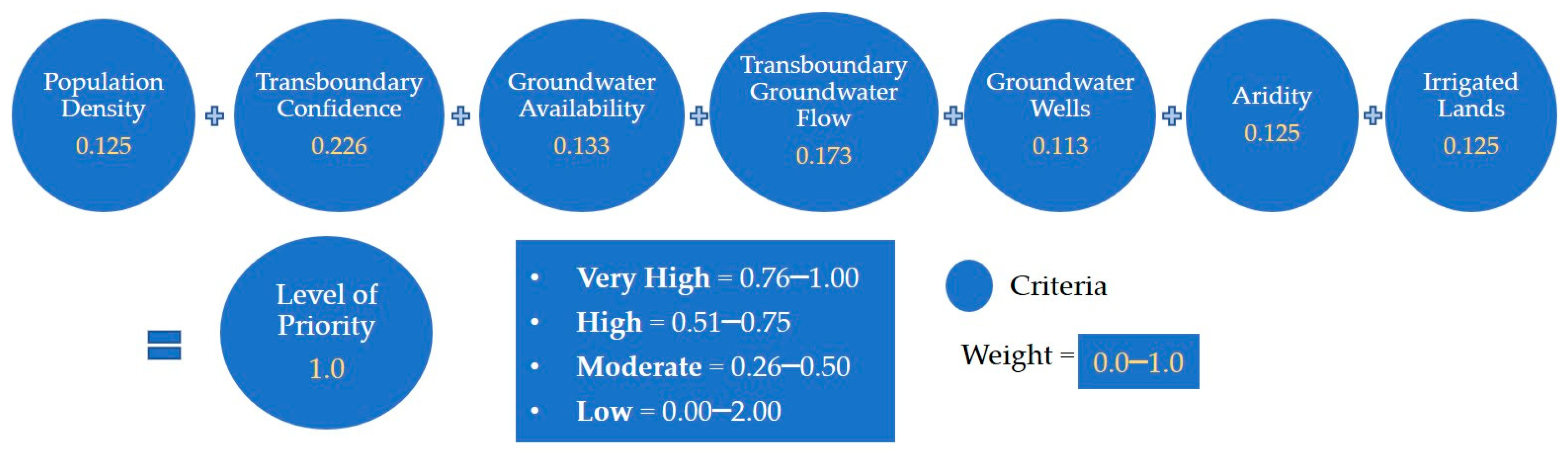
- Population Density: This criterion evaluates the concentration of people living within the aquifer’s limit. It reflects human demand for water resources, as a higher population density is often associated with a greater groundwater demand and a higher potential for water quality and availability issues. This criterion helps prioritize aquifers by considering how densely populated areas may influence changes in water resources, making aquifers with higher population densities more critical for research. The population was determined using GIS tools, U.S. Census Bureau (2020) [26], and INEGI (2020) [27] data. The population within each city and town that comprised each aquifer was aggregated to identify the total population within the aquifer.
- Transboundary Confidence: The confidence level in the transboundary nature of each aquifer is categorized into three tiers—reasonable, some, and limited—based on the framework established by Sanchez et al. (2016) [23] and as reported in subsequent studies [37,38]. This classification relies on an evaluation of geological and administrative criteria to determine the degree of transboundary connectivity. In this AHP analysis, aquifers with higher transboundary confidence levels are assigned greater priority, emphasizing their importance in managing and understanding cross-border water resources.
- Groundwater Availability: This criterion evaluates the balance between groundwater recharge and extraction to assess groundwater availability [39,40,41,42,43,44,45,46,47]. In Mexico, the National Water Commission (CONAGUA) is mandated under the National Water Law and its regulations to publish the annual average availability of groundwater for each aquifer, as outlined in the Official Mexican Standard NOM-011-CONAGUA-2015 [48]. This standard provides the specifications and method for determining groundwater availability through a water balance approach. The calculation involves estimating the total recharge (R) to the aquifer, subtracting the natural discharge (DNC), and further deducting the volume of groundwater extraction (VEAS). Groundwater availability (DMA) is expressed as DMA = R − DNC − VEAS, where a positive value indicates a surplus and a negative value reflects overextraction or resource stress. While CONAGUA’s groundwater availability studies are specific to Mexican aquifers, they provide a valuable framework for assessing sustainability trends in a binational context by providing insights into the balance between recharge and extraction. The results for this criterion are expressed in Millions of Cubic Meters (MCM) per year.
- Transboundary Groundwater Flow: This criterion assesses the horizontal flow of groundwater across the international boundary, which is an important indicator of the interconnectedness and shared dependency on transboundary aquifer systems. Transboundary groundwater flow data for this study were derived from the water availability reports published by CONAGUA for the aquifers under consideration [39,40,41,42,43,44,45,46,47]. According to the Official Mexican Standard NOM-011-CONAGUA-2015 [48], the groundwater discharge of an aquifer is calculated by applying Darcy’s law to specific outflow sections, which are defined based on the configuration of groundwater levels. This calculation incorporates variations in groundwater levels over the time period analyzed, providing an estimate of the volume of water flowing horizontally through the aquifer. The results for this criterion are expressed in Millions of Cubic Meters (MCM) per year.
- Groundwater Wells: This criterion is based on the number of registered groundwater wells in both the United States and Mexico. The data for the United States were obtained from the Arizona Department of Water Resources GIS Data portal (https://gisdata2016-11-18t150447874z-azwater.opendata.arcgis.com/ (accessed on 1 September 2024)) [49], while the data for Mexico were sourced from the Public Registry of Water Rights maintained by CONAGUA (https://app.conagua.gob.mx/consultarepda.aspx (accessed on 1 September 2024)) [50]. The number of wells is used as a proxy for groundwater extractions, with the assumption that a higher number of wells corresponds to greater extraction pressure on the aquifer system, thereby increasing its priority for assessment. This assumption arises from the lack of consistent and homogenous well information across the United States and Mexico. In the United States, relevant well data include information on well depth, water level, casing depth, type and diameter, and pump rate (rated pumping capacity). In contrast, Mexico’s registry provides information on well use and the groundwater concessions granted by the federal government. A concession specifies the allowable volume of water that can be extracted from a particular well or aquifer. These concessions typically have durations ranging from five to thirty years, with the possibility of renewal upon expiration. To gain a more accurate understanding of actual groundwater usage, flow meters or water accounting systems are recommended to monitor and record the total volume of water extracted over time. However, such systems are not available for all wells within the border region, presenting a challenge for the comprehensive assessment of groundwater use.
- Aridity: In this AHP analysis, an aridity index (AI) was developed by the authors to evaluate the historical climatological stress of the basin. The aridity index (AI) measures the degree of climatic dryness based on the annual ratio of precipitation to potential evapotranspiration and the changes in barren land cover within the basin. A lower AI indicates a more arid region, and an increase in barren land cover signals greater desertification. The AI was calculated using the TerraClimate dataset [51].
- Irrigated Lands: This criterion assesses the extent of land irrigated using groundwater resources. Larger irrigated areas typically indicate higher water demand, placing significant pressure on the aquifer. The data were obtained from national census surveys published by the Food and Agriculture Organization (FAO) and the World Bank. The dataset development is described in Siebert et al., 2005, 2007, and 2013 [52,53,54] and can be downloaded at https://www.fao.org/aquastat/en/geospatial-information/global-maps-irrigated-areas/latest-version/ (24 June 2024). The results are presented in hectares (Has) of irrigated lands.
2.2.2. Assigning Weights to Criteria
3. Results
4. Discussion
5. Conclusions
Author Contributions
Funding
Data Availability Statement
Acknowledgments
Conflicts of Interest
References
- Megdal, S.B.; Mumme, S.; Roberto, S.; Rosario, S.; Tapia-Villaseñor, E.M.; Cruz Ayala, M.-B.; Oscar, I. Reaching Groundwater Agreements on the Border Between Mexico and the United States: Science and Policy Fundamentals. In Transboundary Aquifers: Challenges and the Way Forward; Sanchez, R., Ed.; UNESCO: Paris, France, 2022; pp. 46–51. 246p. [Google Scholar]
- Mumme, S.; Megdal, S.B.; Sanchez, R.; Brause, H.; Salmon, R.; Tapia-Villasenor, E.; Ibanez, O.; De la Parra, C.; Ayala, M.-B.C. Crafting Binational Groundwater Agreements: Preconditions for Progress Along the Mexico-U.S. Boundary. Water Econ. Policy 2024, 2371007-1. [Google Scholar] [CrossRef]
- Varady, R.G.; Gerlak, A.K.; Mumme, S.P. ‘Megadrought’ Along Border Strains US-Mexico Water Relations. THE CONVERSATION. 2021. Available online: https://theconversation.com/megadrought-along-border-strains-us-mexico-water-relations-160338 (accessed on 30 December 2024).
- USGCRP. Fifth National Climate Assessment; U.S. Global Change Research Program: Washington, DC, USA, 2023. [Google Scholar]
- USGS. Water Resources Research Act Program, U.S. Geological Survey. Available online: https://www.usgs.gov/programs/water-resources-research-act-program (accessed on 30 December 2024).
- Megdal, S.; Sención, R.; Scott, C.A.; Díaz, F.; Oroz, L.; Callegary, J.; Varady, R.G. Institutional Assessment of the Transboundary Santa Cruz and San Pedro Aquifers on the United States-Mexico Border. In Proceedings of the International Conference “Transboundary Aquifers: Challenges and New Directions”, Paris, France, 6–8 December 2010; p. 6. [Google Scholar]
- IBWC. Joint Report of the Principal Engineers Regarding the Joint Cooperative Process United States-Mexico for the Transboundary Aquifer Assessment Program; International Boundary and Water Comission: El Paso, TX, USA, 2009. [Google Scholar]
- Megdal, S.B. Reflections: Testifying on Reauthorization of the Transboundary Aquifer Assessment Program, Water Resources Research Center (WRRC). 2023. Available online: https://wrrc.arizona.edu/sites/wrrc.arizona.edu/files/2023-10/Reflections-Testifying-on-Reauthorization-TAAP_0.pdf (accessed on 30 December 2024).
- Callegary, J.B.; Minjarez, I.; Tapia Villaseñor, E.M.; dos Santos, P.; Monreal Saavedra, R.; Grijalva Noriega, F.J.; Scott, C.A.; Megdal, S.B.; Oroz Ramos, L.A.; Rangel Medina, M.; et al. Binational Study of the Transboundary San Pedro Aquifer, International Boundary and Water Comission. 2016. Available online: https://www.ibwc.gov/wp-content/uploads/2023/06/San_Pedro_Binational_Report_En_01122017.pdf (accessed on 15 December 2024).
- Tapia-Villaseñor, E.M.; Shamir, E.; Megdal, S.B.; Petersen-Perlman, J.D. Impacts of Variable Climate and Effluent Flows on the Transboundary Santa Cruz Aquifer. JAWRA J. Am. Water Resour. Assoc. 2020, 56, 409–430. [Google Scholar] [CrossRef]
- Shamir, E.; Tapia-Villaseñor, E.M.; Cruz-Ayala, M.-B.; Megdal, S.B. A Review of Climate Change Impacts on the USA-Mexico Transboundary Santa Cruz River Basin. Water 2021, 13, 1390. [Google Scholar] [CrossRef]
- Tapia-Villaseñor, E.M.; Shamir, E.; Cruz-Ayala, M.-B.; Megdal, S.B. Assessing Groundwater Withdrawal Sustainability in the Mexican Portion of the Transboundary Santa Cruz River Aquifer. Water 2022, 14, 233. [Google Scholar] [CrossRef]
- Tapia-Villaseñor, E.M.; Megdal, S.B. The U.S.-Mexico Transboundary Aquifer Assessment Program as a Model for Transborder Groundwater Collaboration. Water 2021, 13, 530. [Google Scholar] [CrossRef]
- Petersen-Perlman, J.D.; Albrecht, T.R.; Tapia-Villaseñor, E.M.; Varady, R.G.; Megdal, S.B. Science and Binational Cooperation: Bidirectionality in the Transboundary Aquifer Assessment Program in the Arizona-Sonora Border Region. Water 2021, 13, 2364. [Google Scholar] [CrossRef]
- Megdal, S.B. Factors that Contribute to Successful Diplomatic Outcomes: Case Study of the Colorado River Basin Cross-Boundary Institution. In The Water Diplomacy Handbook; Routledge (Taylor & Francis Group): Oxford, UK, 2024; pp. 1–12. Available online: https://wrrc.arizona.edu/publication/prepublication-excerpt-factors-contribute-successful-diplomatic-outcomes-case-study (accessed on 15 December 2024).
- California Department of Water Resources. Basin Prioritization; California Department of Water Resources: Sacramento, CA, USA, 2024. [Google Scholar]
- Illinois EPA. Groundwater Protection Planning Regions; Illinois EPA: Springfield, IL, USA, 2024. [Google Scholar]
- Sky Island Alliance. Sky Island Alliance Springs Prioritization Tool; Sky Island Alliance: Tucson, AZ, USA, 2024. [Google Scholar]
- Vishwakarma, A.; Goswami, A.; Pradhan, B. Prioritization of sites for Managed Aquifer Recharge in a semi-arid environment in western India using GIS-Based multicriteria evaluation strategy. Groundw. Sustain. Dev. 2021, 12, 100501. [Google Scholar] [CrossRef]
- Rodríguez-Merino, A.; García-Murillo, P.; Fernández-Zamudio, R. Combining multicriteria decision analysis and GIS to assess vulnerability within a protected area: An objective methodology for managing complex and fragile systems—ScienceDirect. Ecol. Indic. 2020, 108, 105738. [Google Scholar] [CrossRef]
- Atkins, A.E.P.; Langarudi, S.P.; Fernald, A.G. Modeling as a Tool for Transboundary Aquifer Assessment Prioritization. Water 2021, 13, 2685. [Google Scholar] [CrossRef]
- United Nations Environment Programme—DHI Centre on Water and Environment (UNEP—DHI); UNEP. Transboundary Waters Assessment Programme. Volume 3: River Basins; United Nations Environment Programme: Nairobi, Kenya, 2016. [Google Scholar]
- Sanchez, R.; Lopez, V.; Eckstein, G. Identifying and characterizing transboundary aquifers along the Mexico–US border: An initial assessment. J. Hydrol. 2016, 535, 101–119. [Google Scholar] [CrossRef]
- International Groundwater Resources Assessment Centre (IGRAC); United Nations Educational, Scientific and Cultural Organization—International Hydrological Programme (UNESCO—IHP). Transboundary Aquifer of the World [Map]; Update 2021; IGRAC; UNESCO—IHP: Delf, The Netherlands, 2020. [Google Scholar]
- Gobierno del Estado de Sonora. Plan Hídrico Sonora 2023–2053; Hermosillo: Sonora, México, 2023; Available online: https://www.sonora.gob.mx/images/documentos/plan-hidrico-sonora-2023-2053.pdf (accessed on 15 June 2024).
- United States Census Bureau. 2020 Census Results. 2020. Available online: https://www.census.gov/programs-surveys/decennial-census/decade/2020/2020-census-results.html (accessed on 15 June 2024).
- Instituto Nacional de Estadística y Geografía (INEGI). Censo de Población y Vivienda 2020; INEGI: Aguascalientes, Mexico, 2020. [Google Scholar]
- United States Department of Agriculture National Agricultural Statistics Service Mountain Region, Arizona Field Office. Arizona Agricultural Statistics; United States Department of Agriculture National Agricultural Statistics Service Mountain Region, Arizona Field Office: Phoenix, AZ, USA, 2020. [Google Scholar]
- Gobierno del Estado de Sonora. Economic Overview of Sonora. 2020. Available online: https://www.economia.gob.mx/datamexico/en/profile/geo/sonora-so?redirect=true (accessed on 1 December 2024).
- Secretaría de Economía. Economic Profile of Nogales, Sonora. 2020. Available online: https://www.economia.gob.mx/datamexico/en/profile/geo/nogales (accessed on 1 December 2024).
- Sierra Vista Arizona. Economic Development. 2024. Available online: https://www.sierravistaaz.gov/our-city/departments/economic-development (accessed on 1 December 2024).
- Grupo Mexico. Mining Operations in Cananea. 2020. Available online: https://www.gmexico.com/Pages/default.aspx (accessed on 1 December 2024).
- City of Douglas. Douglas Economic Development. 2024. Available online: https://www.douglasaz.gov/176/Economic-Development (accessed on 1 December 2024).
- Alamanos, A.; Mylopoulos, N.; Loukas, A.; Gaitanaros, D. An Integrated Multicriteria Analysis Tool for Evaluating Water Resource Management Strategies. Water 2018, 10, 1795. [Google Scholar] [CrossRef]
- Malczewski, J. GIS-based multicriteria decision analysis: A survey of the literature. Int. J. Geogr. Inf. Sci. 2006, 20, 703–726. [Google Scholar] [CrossRef]
- Saaty, R.W. The Analytic Hierarchy Process—What it is and how it is used. Math Model. 1987, 9, 161–176. [Google Scholar] [CrossRef]
- Sanchez, R.; Eckstein, G. Aquifers Shared Between Mexico and the United States: Management Perspectives and Their Transboundary Nature. Groundwater 2017, 55, 495–505. [Google Scholar] [CrossRef] [PubMed]
- Sanchez, R.; Rodriguez, L. Transboundary Aquifers between Baja California, Sonora and Chihuahua, Mexico, and California, Arizona and New Mexico, United States: Identification and Categorization. Water 2021, 13, 2878. [Google Scholar] [CrossRef]
- CONAGUA. Actualización de la Disponibilidad Media Anual de Agua en el Acuífero Nogales (2650), Estado de Sonora; Diario Oficial de la Federación (DOF): Ciudad de México, México, 2024; Available online: https://sigagis.conagua.gob.mx/gas1/Edos_Acuiferos_18/sonora/DR_2650.pdf (accessed on 1 September 2024).
- CONAGUA. Actualización de la Disponibilidad Media Anual de Agua en el Acuífero Agua Prieta (2629), Estado de Sonora; Diario Oficial de la Federación (DOF): Ciudad de México, México, 2024; Available online: https://sigagis.conagua.gob.mx/gas1/Edos_Acuiferos_18/sonora/DR_2629.pdf (accessed on 1 September 2024).
- CONAGUA. Actualización de la Disponibilidad Media Anual de Agua en el Acuífero Río San Pedro (2616), Estado de Sonora; Diario Oficial de la Federación (DOF): Ciudad de México, México, 2024; Available online: https://sigagis.conagua.gob.mx/gas1/Edos_Acuiferos_18/sonora/DR_2616.pdf (accessed on 1 September 2024).
- CONAGUA. Actualización de la Disponibilidad Media Anual de Agua en el Acuífero Sonoyta-Puerto Peñasco (2603), Estado de Sonora; Diario Oficial de la Federación (DOF): Ciudad de México, México, 2024; Available online: https://sigagis.conagua.gob.mx/gas1/Edos_Acuiferos_18/sonora/DR_2603.pdf (accessed on 1 September 2024).
- CONAGUA. Actualización de la Disponibilidad Media Anual de Agua en el Acuífero Valle de San Luis Río Colorado (2601), Estado de Sonora; Diario Oficial de la Federación (DOF): Ciudad de México, México, 2024; Available online: https://sigagis.conagua.gob.mx/gas1/Edos_Acuiferos_18/sonora/DR_2601.pdf (accessed on 1 September 2024).
- CONAGUA. Actualización de la Disponibilidad Media Anual de Agua en el Acuífero Los Vidrios (2602), Estado de Sonora; Diario Oficial de la Federación (DOF): Ciudad de México, México, 2024; Available online: https://sigagis.conagua.gob.mx/gas1/Edos_Acuiferos_18/sonora/DR_2602.pdf (accessed on 1 September 2024).
- CONAGUA. Actualización de la Disponibilidad Media Anual de Agua en el Acuífero Río Altar (2608), Estado de Sonora; Diario Oficial de la Federación (DOF): Ciudad de México, México, 2024; Available online: https://sigagis.conagua.gob.mx/gas1/Edos_Acuiferos_18/sonora/DR_2608.pdf (accessed on 1 September 2024).
- CONAGUA. Actualización de la Disponibilidad Media Anual de Agua en el Acuífero Arroyo Seco (2607), Estado de Sonora; Diario Oficial de la Federación (DOF): Ciudad de México, México, 2024; Available online: https://sigagis.conagua.gob.mx/gas1/Edos_Acuiferos_18/sonora/DR_2607.pdf (accessed on 1 September 2024).
- CONAGUA. Actualización de la Disponibilidad Media Anual de Agua en el Acuífero Arroyo San Bernardino (2630), Estado de Sonora; Diario Oficial de la Federación (DOF): Ciudad de México, México, 2024; Available online: https://sigagis.conagua.gob.mx/gas1/Edos_Acuiferos_18/sonora/DR_2630.pdf (accessed on 1 September 2024).
- Diario Oficial de la Federación (DOF). Norma Oficial Mexicana NOM-011-CONAGUA-2015, Conservación del Recurso Agua-Que Establece las Especificaciones y el Método Para Determinar la Disponibilidad Media Anual de las Aguas Nacionales. Mexico, 27 de marzo de 2015. Available online: https://www.dof.gob.mx/nota_detalle.php?codigo=5387027&fecha=27/03/2015#gsc.tab=0 (accessed on 1 December 2024).
- Arizona Department of Water Resources. Arizona Water Resources GIS Data Portal. Available online: https://gisdata2016-11-18t150447874z-azwater.opendata.arcgis.com/ (accessed on 1 December 2024).
- CONAGUA. Registro Público de Derechos de Agua (REPDA). 2024. Available online: https://app.conagua.gob.mx/consultarepda.aspx (accessed on 1 December 2024).
- Abatzoglou, J.T.; Dobrowski, S.Z.; Parks, S.A.; Hegewisch, K.C. TerraClimate, a high-resolution global dataset of monthly climate and climatic water balance from 1958–2015. Sci. Data 2018, 5, 170191. [Google Scholar] [CrossRef] [PubMed]
- Siebert, S.; Döll, P.; Hoogeveen, J.; Faures, J.M.; Frenken, K.; Feick, S. Development and validation of the global map of irrigation areas. Hydrol. Earth Syst. Sci. 2005, 9, 535–547. [Google Scholar] [CrossRef]
- Siebert, S.; Döll, P.; Hoogeveen, J.; Frenken, K. Global Map of Irrigation Areas, Version 4.0.1; Johann Wolfgang Goethe University: Frankfurt am Main, Germany; Food and Agriculture Organization of the United Nations: Rome, Italy, 2007. [Google Scholar]
- Siebert, S.; Henrich, V.; Frenken, K. Update of the Digital Global Map of Irrigation Areas to Version 5; Food and Agriculture Organization of the United Nations: Rome, Italy, 2013; Available online: https://openknowledge.fao.org/server/api/core/bitstreams/02e5f498-eb5d-4a08-b501-b3e05fdefc57/content (accessed on 1 December 2024).

| Aquifer Name | Aquifer Area (km2) | Population | Population Density (Person/km2) | Transboundary Confidence | Groundwater Availability (MCM */Year) | Transboundary Groundwater Flow (MCM/year) | No. of Groundwater Wells | Aridity Index (% Change) | Irrigated Lands (Hectares) |
|---|---|---|---|---|---|---|---|---|---|
| Los Vidrios–Western Mexican Drainage | 7189.21 | 53 | 0.01 | Some | 0.00 | 4 | MX: 1 U.S.: 33 Total: 34 | −24.9 | 374 |
| Sonoyta–Puerto Peñasco–San Simon Wash | 14,731 | 79,339 | 5.4 | Reasonable | −83.72 | 9 | MX: 525 U.S.: 27 Total: 552 | −19.2 | 5495 |
| Río Altar | 2794 | 11,188 | 4.0 | Limited | 0.00 | 7.3 | MX: 558 U.S.: 0 Total: 558 | −12.5 | 9146 |
| Río Alisos | 890 | 3264 | 3.7 | Limited | 0.00 | 0 | MX:173 U.S.: 0 Total: 173 | −12.7 | 2196 |
| Santa Cruz | 3891 | 306,989 | 78.9 | Reasonable | 0.00 | 2 | MX: 297 U.S.: 3855 Total: 4152 | −14.3 | 2965 |
| San Pedro | 4469 | 115,749 | 25.9 | Reasonable | −6.71 | 10.8 | MX: 177 U.S.: 5883 Total: 6060 | −13.6 | 1054 |
| Douglas–Agua Prieta | 3780 | 116,019 | 30.7 | Reasonable | −0.05 | 2.6 | MX: 127 U.S.: 4009 Total: 4136 | −12.5 | 5035 |
| Arroyo San Bernardino | 2658.08 | 108 | 0.04 | Some | 0.00 | 8.4 | MX: 25 U.S.: 249 Total: 274 | −12.1 | 364 |
| Criteria | Weight of Criteria | Alternative | Weight of Alternative | Unit of Alternative |
|---|---|---|---|---|
| Population density | 0.125 |
|
| Persons per square kilometer |
| Transboundary confidence | 0.226 |
|
| NA |
| Groundwater availability | 0.113 |
|
| Millions of cubic meters (MCM/year) |
| Transboundary groundwater flow | 0.173 |
|
| Millions of cubic meters (MCM/year) |
| Groundwater wells | 0.113 |
|
| Number of wells |
| Aridity | 0.125 |
|
| Relative change in aridity index (%) |
| Irrigated lands | 0.125 |
|
| Hectares |
| Aquifer Name | Population Density | Transboundary Confidence | Groundwater Availability | Transboundary Groundwater Flow | No. of Groundwater Wells | Aridity Index | Irrigated Lands | AHP Score | Level of Priority |
|---|---|---|---|---|---|---|---|---|---|
| Sonoyta–Puerto Peñasco–San Simon Wash System | 0.096 | 0.539 | 0.466 | 0.161 | 0.161 | 0.161 | 0.161 | 0.564 | 1 |
| Santa Cruz Aquifer | 0.477 | 0.539 | 0.096 | 0.096 | 0.277 | 0.096 | 0.096 | 0.546 | 2 |
| San Pedro Aquifer | 0.161 | 0.539 | 0.096 | 0.277 | 0.277 | 0.096 | 0.096 | 0.529 | 3 |
| Douglas–Agua Prieta Aquifer | 0.161 | 0.539 | 0.096 | 0.096 | 0.277 | 0.096 | 0.161 | 0.481 | 4 |
| Los Vidrios–Western Mexican Drainage | 0.096 | 0.297 | 0.096 | 0.096 | 0.096 | 0.466 | 0.096 | 0.388 | 5 |
| Río Altar | 0.096 | 0.164 | 0.096 | 0.161 | 0.161 | 0.096 | 0.466 | 0.364 | 6 |
| Arroyo San Bernardino–San Bernardino Valley Aquifer | 0.096 | 0.297 | 0.096 | 0.161 | 0.161 | 0.096 | 0.096 | 0.331 | 7 |
| Río Alisos Aquifer | 0.096 | 0.164 | 0.096 | 0.096 | 0.161 | 0.096 | 0.096 | 0.245 | 8 |
Disclaimer/Publisher’s Note: The statements, opinions and data contained in all publications are solely those of the individual author(s) and contributor(s) and not of MDPI and/or the editor(s). MDPI and/or the editor(s) disclaim responsibility for any injury to people or property resulting from any ideas, methods, instructions or products referred to in the content. |
© 2025 by the authors. Licensee MDPI, Basel, Switzerland. This article is an open access article distributed under the terms and conditions of the Creative Commons Attribution (CC BY) license (https://creativecommons.org/licenses/by/4.0/).
Share and Cite
Tapia-Villaseñor, E.M.; Megdal, S.B.; Shamir, E. Prioritizing Transboundary Aquifers in the Arizona–Sonora Region: A Multicriteria Approach for Groundwater Assessment. Water 2025, 17, 443. https://doi.org/10.3390/w17030443
Tapia-Villaseñor EM, Megdal SB, Shamir E. Prioritizing Transboundary Aquifers in the Arizona–Sonora Region: A Multicriteria Approach for Groundwater Assessment. Water. 2025; 17(3):443. https://doi.org/10.3390/w17030443
Chicago/Turabian StyleTapia-Villaseñor, Elia M., Sharon B. Megdal, and Eylon Shamir. 2025. "Prioritizing Transboundary Aquifers in the Arizona–Sonora Region: A Multicriteria Approach for Groundwater Assessment" Water 17, no. 3: 443. https://doi.org/10.3390/w17030443
APA StyleTapia-Villaseñor, E. M., Megdal, S. B., & Shamir, E. (2025). Prioritizing Transboundary Aquifers in the Arizona–Sonora Region: A Multicriteria Approach for Groundwater Assessment. Water, 17(3), 443. https://doi.org/10.3390/w17030443