


Sedimentary Sequence and Age of Core NTCJ1 in the Sheyang Estuary, Western South Yellow Sea: A Re-Interpretation


Abstract
:1. Introduction
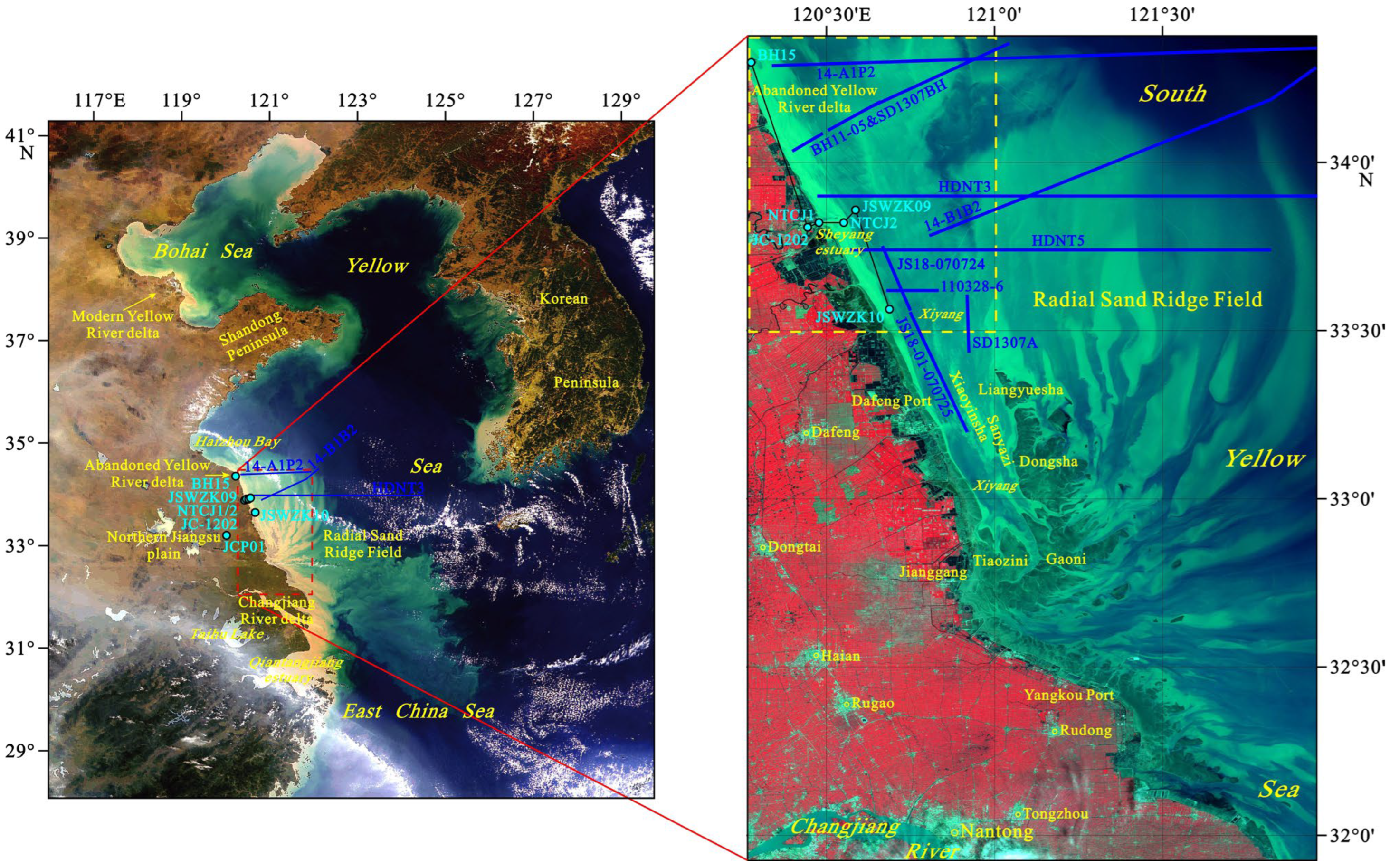
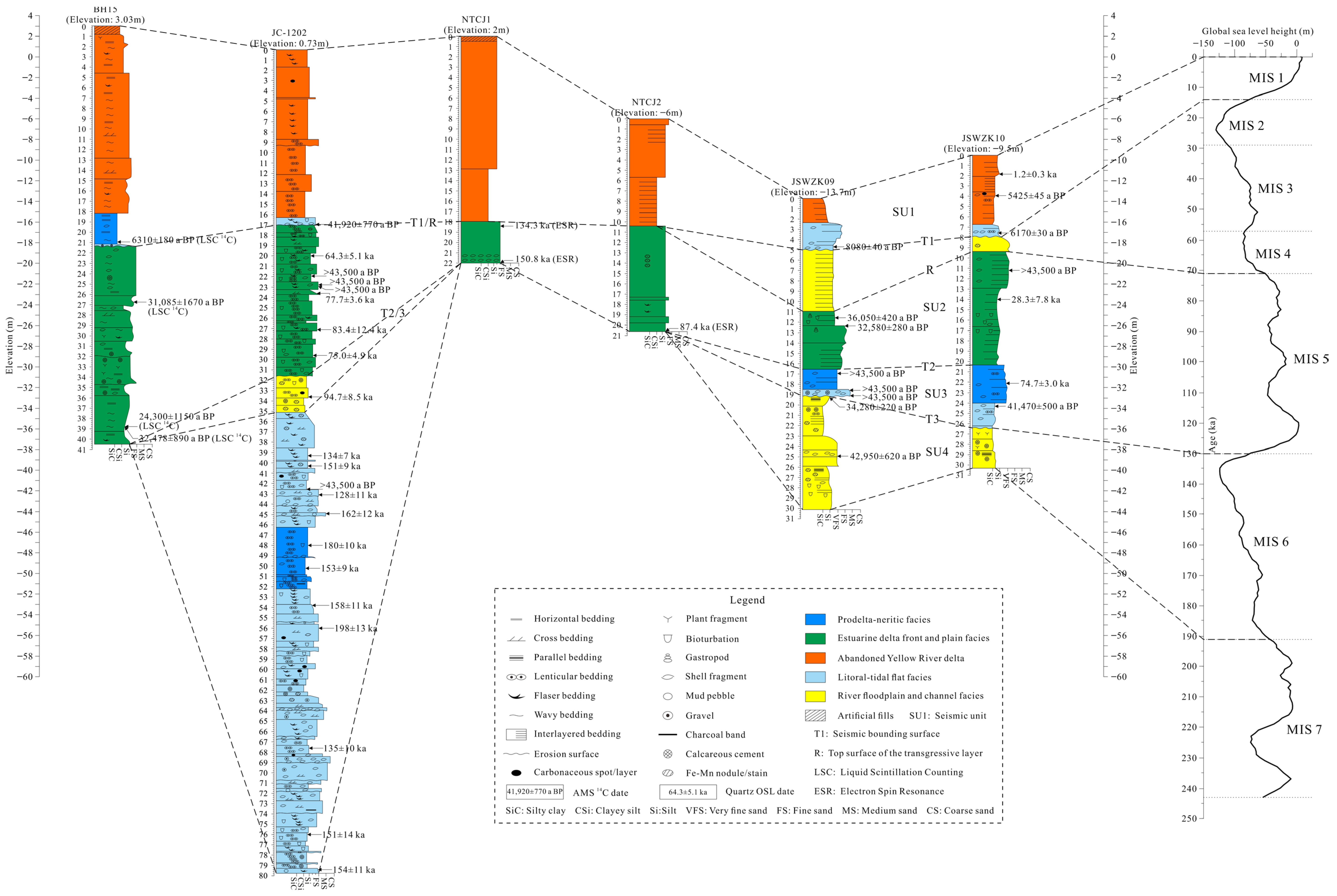
2. General Settings
3. Materials and Methods
4. Results
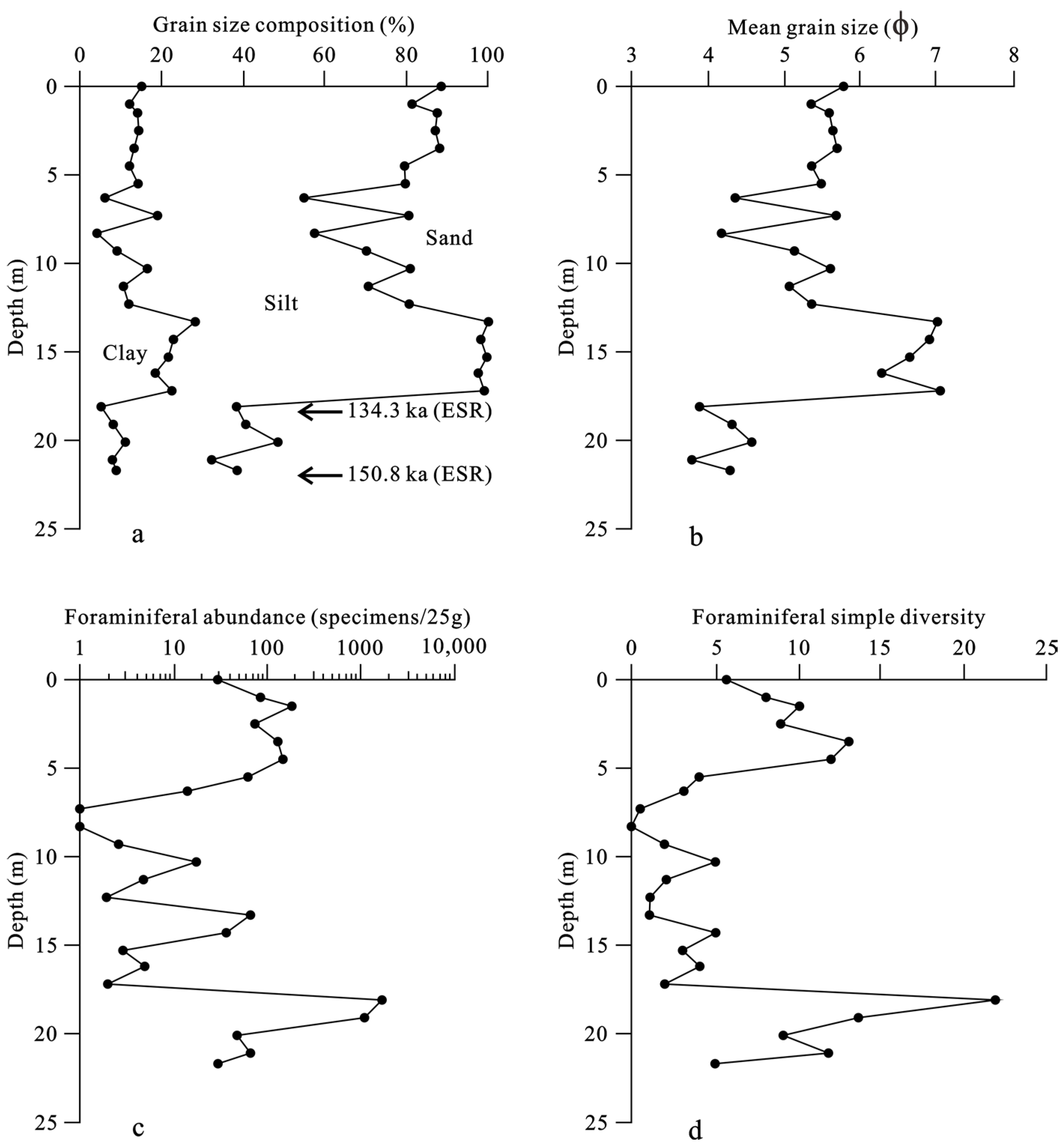
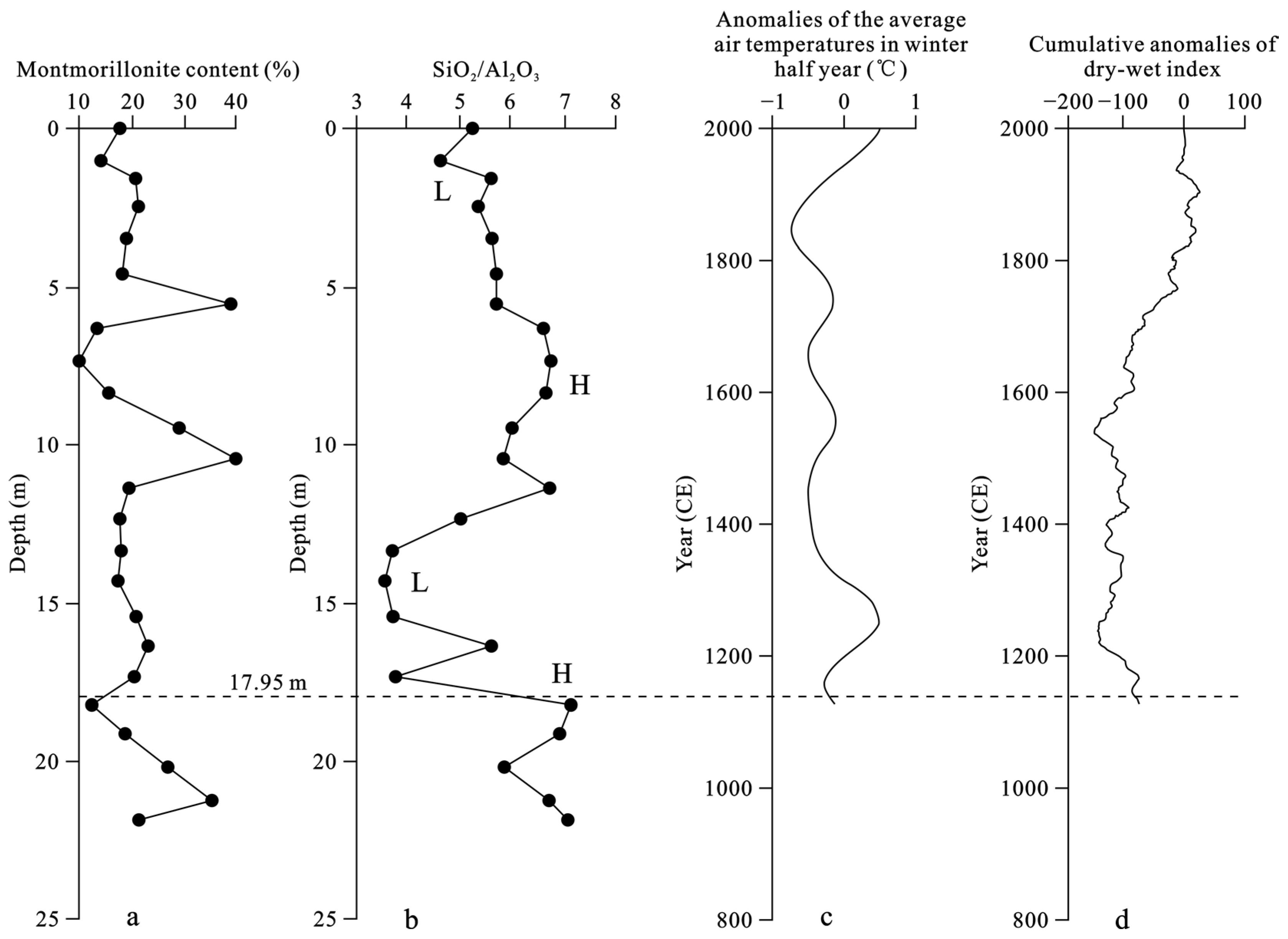
4.1. Lithology, Grain Size and ESR Dating
4.2. Ostracods and Foraminifera
4.3. Clay Minerals
4.4. SiO2/Al2O3 Ratio
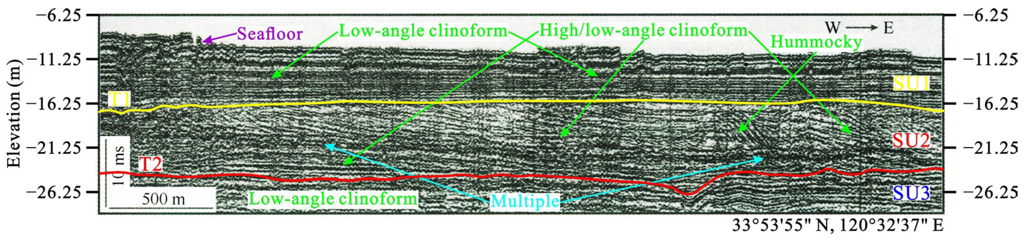
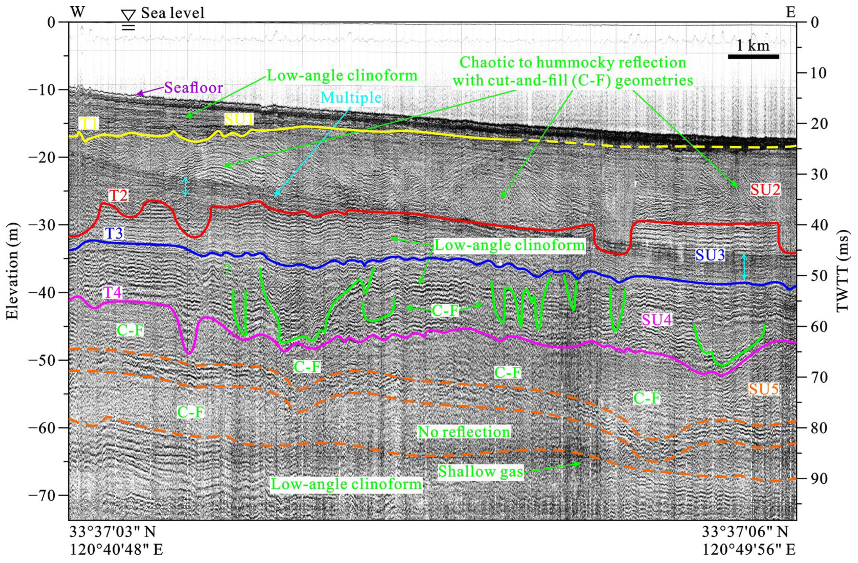
5. Discussion
6. Conclusions
Author Contributions
Funding
Data Availability Statement
Acknowledgments
Conflicts of Interest
References
- Gao, S. Coastal and shelf sedimentation in association with dynamic processes, global change impacts, and stratigraphic records: An overview of the scientific problems. Quat. Sci. 2010, 30, 856–863. (In Chinese) [Google Scholar]
- Gao, S.; Collins, M.B. Holocene sedimentary systems on continental shelves. Mar. Geol. 2014, 352, 268–294. [Google Scholar] [CrossRef]
- Li, G.X.; Li, P.; Liu, Y.; Qiao, L.L.; Ma, Y.Y.; Xu, J.S.; Yang, Z.G. Sedimentary system response to the global sea level change in the East China Seas since the last glacial maximum. Earth-Sci. Rev. 2014, 139, 390–405. [Google Scholar] [CrossRef]
- Xia, F.; Zhang, Y.Z.; Liu, D.Z. Rethinking on shallow sedimentary sequence and its evolution of the Xiyang tidal channel in the Radial Sand Ridge Field, South Yellow Sea. Mar. Geol. Quat. Geol. 2021, 41, 13–26. (In Chinese) [Google Scholar]
- The Official Website of Jiangsu Sheyang Port Development Group Limited Company. Available online: http://www.sheyangport.com/ (accessed on 25 September 2023).
- Ren, M.E. Report for the Comprehensive Investigation on Coastal Zones and Recourses of Tidal Flats in Jiangsu Province; China Ocean Press: Beijing, China, 1986; pp. 1–517. (In Chinese) [Google Scholar]
- Shi, F.Z. Atlas for the Comprehensive Investigation on Coastal Zones and Resources of Tidal Flats in China (Jiangsu Province Section); Jiangsu Provincial Bureau of Surveying and Mapping: Nanjing, China, 1988; pp. 25–27. (In Chinese) [Google Scholar]
- Chen, X.X.; Miao, J.Y.; Song, Y.Q. A preliminary study of Huaihe River delta. Mar. Sci. 1993, 4, 10–13. (In Chinese) [Google Scholar]
- State Pilot Laboratory of Coast and Island Exploitation, Nanjing University. Research Report for the Regulation of the Mouth Bar in Sheyang Harbor; Nanjing University: Nanjing, China, 1991; pp. 1–106. (In Chinese) [Google Scholar]
- Song, Z.J.; Zhang, Z.X.; Huang, H.J. Characteristics and depositional setting of the high resolution shallow seismic profile in the South Yellow Sea. Mar. Geol. Quat. Geol. 2005, 25, 33–40. (In Chinese) [Google Scholar]
- Gu, Z.F.; Zhang, Z.X. Shallow seismic stratigraphy and sedimentary character in the western South Yellow Sea. Mar. Geol. Quat. Geol. 2009, 29, 95–106. (In Chinese) [Google Scholar]
- Li, J.; Zhang, Z.X.; Zhang, W.G.; An, Y.N.; Wang, K. Shallowly-buried paleo-geomorphological features and distribution in the South Yellow Sea and their influence on marine engineering. Mar. Geol. Front. 2011, 27, 48–52. (In Chinese) [Google Scholar]
- Zhang, X.H.; Zhang, Z.X.; Lan, X.H.; Li, R.H. Areal Geology of the South Yellow Sea; China Ocean Press: Beijing, China, 2013; pp. 1–442. (In Chinese) [Google Scholar]
- Tao, Q.Q.; Liu, B.H.; Li, X.S.; Zhang, W.G.; Li, D. Late Pleistocene evolution of the paleo Yangtze delta in the South Yellow Sea. Mar. Geol. Quat. Geol. 2009, 29, 15–24. (In Chinese) [Google Scholar]
- Shi, X.F. Chinese Offshore—Subbottom Sediments; China Ocean Press: Beijing, China, 2012; pp. 139–234. (In Chinese) [Google Scholar]
- Liu, J.; Saito, Y.; Kong, X.H.; Wang, H.; Wen, C.; Yang, Z.G.; Nakashima, R. Delta development and channel incision during marine isotope stages 3 and 2 in the western South Yellow Sea. Mar. Geol. 2010, 278, 54–76. [Google Scholar] [CrossRef]
- Zhang, X. Chronology and sedimentary environment change in the coastal-shelf areas of eastern China since 200 ka. Doctor Dissertation, China University of Geosciences, Wuhan, China, 2021; pp. 1–122. (In Chinese). [Google Scholar]
- He, L.; Ye, S.Y.; Xue, C.T.; Zhao, G.M.; Yang, S.X.; Amorosi, A. Sedimentology and evolution of the Holocene radial tidal sand ridge in the south Yellow Sea, China. Front. Earth Sci. 2023, 10, 1107495. [Google Scholar] [CrossRef]
- Zhang, C.K. Basic Situation of Environments and Resources in the Jiangsu Province Offshore; China Ocean Press: Beijing, China, 2013; pp. 1–683. (In Chinese) [Google Scholar]
- Ye, H. Research on the Comprehensive Development Strategy of Jiangsu Coastal Areas (Vol. Port Traffic): Research on the Port Layout and Traffic Network Construction in Jiangsu Coastal Areas; Jiangsu People’s Publishing House: Nanjing, China, 2008; pp. 1–191. (In Chinese) [Google Scholar]
- China’s National Center of Oceanographic Standards and Metrology. Specification for Oceanographic Survey—Marine Geology and Geophysics Investigation (GB/T 13909-1992); Standards Press of China: Beijing, China, 1992; pp. 1–76. (In Chinese) [Google Scholar]
- Xue, C.T.; Zhou, Y.Q.; Zhu, X.H. The Huanghe River course and delta from end of Late Pleistocene to the 7th century BC. Acta Oceanol. Sin. 2004, 26, 48–61. (In Chinese) [Google Scholar]
- Wang, P.X.; Bian, Y.H. Ostracod/Foraminifer ratios as indicators of sedimentary environments. Acta Micro. Sin. 1986, 3, 37–50. (In Chinese) [Google Scholar]
- Fan, D.J.; Yang, Z.S.; Mao, D.; Guo, Z.G. Clay minerals and geochemistry of the sediments from the Yangtze and Yellow Rivers. Mar. Geol. Quat. Geol. 2001, 21, 7–12. (In Chinese) [Google Scholar]
- Hu, B.Q.; Li, J.; Li, G.G.; Zhao, J.T.; Song, W.Y. Distinguishing the Changjiang and Huanghe sediments: A review. Mar. Geol. Quat. Geol. 2011, 31, 147–156. (In Chinese) [Google Scholar] [CrossRef]
- Ge, Q.S. Climate Change in the Past Dynasties of China; Science Press: Beijing, China, 2011; pp. 61–103. (In Chinese) [Google Scholar]
- Zhong, W.; Wang, L.G.; Xiong, H.G.; Nu, E.B. Climate-Environment changes and possible human activity effect since Mid-Holocene in Hetian Oasis, southern margin of Tarim Basin. J. Desert Res. 2007, 27, 171–176. (In Chinese) [Google Scholar]
- Hu, M.J.; Yang, A.L.; Zhang, W.L. Environmental evolution since the Middle-Late Holocene in the Maqu Plateau reflected by constant element oxides content and ratios. J. Desert Res. 2015, 35, 313–321. (In Chinese) [Google Scholar]
- Wang, J.; Zhou, C.L.; Xu, X.B. Research Report for the Characteristics and Sedimentary Environments of the Shallow Strata of the 10,000-Ton Wharf at Zhongshan Port, Binhai County, Jiangsu Province; Nanjing Normal University: Nanjing, China, 1995; pp. 1–20. (In Chinese) [Google Scholar]
- Spratt, R.M.; Lisiecki, L.E. A Late Pleistocene sea level stack. Clim. Past. 2016, 12, 1079–1092. [Google Scholar] [CrossRef]
- Xia, F.; Zhang, Y.Z.; Wang, Q.; Yin, Y.; Wegmann, K.W.; Liu, J.P. Evolution of sedimentary environments of the middle Jiangsu coast, South Yellow Sea since late MIS 3. J. Geogr. Sci. 2013, 23, 883–914. [Google Scholar] [CrossRef]
- Xia, F. Shallow Sequence Stratigraphy and Sedimentary Evolution of the Xiyang Tidal Channel in the Radial Sand Ridge Field. Ph.D. Thesis, Nanjing University, Nanjing, China, 2016; pp. 1–187. (In Chinese). [Google Scholar]
- Veeken, P.C.H.; van Moerkerken, B. Seismic Stratigraphy and Depositional Facies Models; EAGE Publications bv: Houten, The Netherlands, 2013; pp. 107–214. [Google Scholar]
- Gao, L.; Long, H.; Tamura, T.; Hou, Y.; Shen, J. A ~130 ka terrestrial-marine interaction sedimentary history of the northern Jiangsu coastal plain in China. Mar. Geol. 2021, 435, 106455. [Google Scholar] [CrossRef]


| Sample No. | Depth (m) | U (10−6) | Th (10−6) | K2O (%) | AD (Gy) | Age (ka) | Comment |
|---|---|---|---|---|---|---|---|
| 1E-2 | 18.38–18.41 | 1.44 | 9.09 | 1.92 | 316.9 | 134.3 | Referencable |
| 1E-3 | 21.98–22.00 | 1.41 | 7.75 | 1.94 | 343.9 | 150.8 | Referencable |
| 2E-4 | 20.57–20.60 | 1.74 | 10.9 | 2.14 | 240.3 | 87.4 | Referencable |
Disclaimer/Publisher’s Note: The statements, opinions and data contained in all publications are solely those of the individual author(s) and contributor(s) and not of MDPI and/or the editor(s). MDPI and/or the editor(s) disclaim responsibility for any injury to people or property resulting from any ideas, methods, instructions or products referred to in the content. |
© 2023 by the authors. Licensee MDPI, Basel, Switzerland. This article is an open access article distributed under the terms and conditions of the Creative Commons Attribution (CC BY) license (https://creativecommons.org/licenses/by/4.0/).
Share and Cite
Xia, F.; Zhang, Y.; Wang, L.; Liu, D. Sedimentary Sequence and Age of Core NTCJ1 in the Sheyang Estuary, Western South Yellow Sea: A Re-Interpretation. Water 2023, 15, 3617. https://doi.org/10.3390/w15203617
Xia F, Zhang Y, Wang L, Liu D. Sedimentary Sequence and Age of Core NTCJ1 in the Sheyang Estuary, Western South Yellow Sea: A Re-Interpretation. Water. 2023; 15(20):3617. https://doi.org/10.3390/w15203617
Chicago/Turabian StyleXia, Fei, Yongzhan Zhang, Li Wang, and Dezheng Liu. 2023. "Sedimentary Sequence and Age of Core NTCJ1 in the Sheyang Estuary, Western South Yellow Sea: A Re-Interpretation" Water 15, no. 20: 3617. https://doi.org/10.3390/w15203617
APA StyleXia, F., Zhang, Y., Wang, L., & Liu, D. (2023). Sedimentary Sequence and Age of Core NTCJ1 in the Sheyang Estuary, Western South Yellow Sea: A Re-Interpretation. Water, 15(20), 3617. https://doi.org/10.3390/w15203617