1. Introduction
Emergencies do not affect a secure society. A minimum system of tasks and measures is necessary to protect life, health and property. The system is reduced to the analysis of possible threats and, consequently, reduces the probability of occurrence and elimination of consequences. Act 42/1994 Coll. on Civil Protection is valid in the Slovak Republic. According to this act, an emergency event means a natural disaster, accident, catastrophe, threat to public health of II. degree, the mass arrival of foreigners on the territory of the Slovak Republic, or a terrorist attack. Due to extensive problems, the article will focus on the crash accident. According to this law, an accident is an emergency event that causes a deviation from the steady operating state. As a result, hazardous substances are released or are affected by other destructive factors that affect life, health or property [
1].
Concerning dangerous substances that can occur in an accident, it is necessary to focus on prevention, especially with those that are dangerous to life and human health or toxic to the environment. It is also significant to pay attention to substances that are difficult to dispose of or remove from the environment and can worsen living conditions in the long-term. The last group consists of hazardous substances, which, although not extremely dangerous, are transported or stored in large quantities. The effects of these substances may thus be significant due to their quantity [
2].
An accident involving a dangerous substance can occur during the storage, use or transport of dangerous substances. Storage and production facilities or equipment are among the stationary sources. In addition to stationary sources, however, crisis managers often deal with leaks of hazardous substances during their transport [
3,
4]. This type of leakage is the subject of our paper, where we focus on road transport by tankers between several countries.
Crisis management deals with such events. It is an inseparable part of modern society and the concept of a smart city, which wants to create a safe environment for its inhabitants [
5]. A new trend increasingly used in smart cities and crisis management is digitization. It allows us to predict and manage various events at the same time [
6,
7]. Crisis management planning is mainly concerned with the readiness to react in the event of an emergency so that the system remembers it as quickly as possible. Risk management and crisis management are not separate functions but rather two complementary phases of the same function. They consist of learning aimed at developing the organization’s ability to deal with emergencies and disruption without consequences or with minimal consequences. Subsequently, it is possible to recover quickly from various crises [
8]. Therefore, it is necessary to have proper knowledge of the environment and the ability to anticipate all possible negative impacts that could upset the balance and escalate into a disaster [
9,
10].
Dangerous goods (DG) are transported in various modalities from one or more places of origin to a destination where they are needed. As people need DG to live and work, they are widely distributed in different environments. Dangerous goods transportation (DGT) concerns all kinds of goods such as liquids, gasses, and solids, including radioactive, flammable, explosive, corrosive, oxidizing, asphyxiating, biohazardous, toxic, pathogenic, or allergenic materials. All the mentioned substances have latent or non-latent serious health risks that can harm humans and the environment and destroy surrounding properties or other living organisms [
11]. Accidents involving DG often require a response from various emergency services. Therefore, procedures for the mutual exchange of information and coordination should be adopted [
12]. The severity of the consequences related to road accidents in DGT and the large number of lorries that transport DG daily require the development and use of tools for risk assessment and treatment that can define the risk as a product of event frequency/probability and its consequences [
13]. The case studies in this area illustrate the factors leading to crisis events and their impacts on facilities, the environment and nearby communities. The studies also specify steps that can be taken by prevention decision makers and local and state emergency managers to reduce the risks posed by emergency events through changes in procedures and investment in equipment [
14].
Risks related to DGT can be characterised by various aspects, such as the type and quantity of dangerous goods, vehicle and road characteristics, traffic and weather conditions and population density. Some of these issues are time-dependent (traffic and weather conditions, population density). This aspect implies the complexity of such analysis and supports the use of modelling, and, thus, simulation models. Many approaches to simulation modelling have recently been adopted, such as:
System Dynamics (SD), which is characterised by a high level of abstraction, low details and a strategic level [
15].
Discrete Event (DE), a mostly discrete model characterised by a medium abstraction level, medium details and a tactical level [
16].
Agent-Based (AB), also referred to as ABM (agent-based modelling), ABS (agent-based systems or simulation), and IBM (individual-based modelling), which are mostly decentralized and preferred for complex systems [
17].
According to McKinsey, 70% of senior managers have begun planning to adopt digital risk management. The use of risk management software is becoming increasingly important in maintaining resilience to crisis events [
18].
The main advantage of simulation is that it provides more information on the behaviour of the DGT system in different situations, considering involved decision makers, various what-if hypotheses and numerous approaches. In terms of emergency management or planning activities, e.g., operative training, models and simulations could be applicable for technicians, drivers, controllers, firefighters, emergency operators and other DGT subjects.
In the context of developing a decision-making support tool for final users working in the field of emergency response planning, we propose a comprehensive system.
The system consists of three available basic tools. One of them we apply in our case study:
We decided to demonstrate by modelling with the ALOHA software used in this area. In our case study, we also consider the impacts on neighbouring states.
The article is focused on the use of possibilities of modelling the dispersion of toxic substances in the ALOHA software in border areas, with an emphasis on the preparedness of crisis managers and improving the prevention and response of the population to crisis events.
2. Materials and Methods
Each country should analyse the potential risks to its environment. Significant attention needs to be paid to the atmosphere, as leakages of dangerous substances in the border area can have a negative impact on several countries. In our paper, we focused on the territory of Slovakia. Slovakia has eight regions (NUTS 3), one of which was selected as a model: the Žilina Region. There were several reasons for this decision, including the fact that the workplace of several authors is located there. The authors also regularly communicate with the regional management in this locality. This region is bordered by two other states. Its location indicates the possibility of transporting dangerous substances from the surrounding states. Due to the fact that dangerous goods are transported through the Žilina Region only by road and rail, it is possible to deal only with the ADR agreement for road transport and the RID order for rail transport. Due to the wide range of issues, the paper will focus on the road transport of dangerous goods.
The simulation software tool ALOHA CAMEO was used to create the map. This programme is available for free download in the current version for Windows at
www.epa.gov (accessed on 18 May 2022). It is regularly updated and supplemented with new chemicals. As it features an extensive library, it can evaluate many chemicals. If a substance is not included in the library, it can be added to the list based on knowledge of the important physicochemical and toxicological data provided for each dangerous substance. The programme is used to evaluate the leakage of a dangerous substance and allows the selection of location and atmospheric conditions. Based on the tank dimensions, it determines the filling height of the tank and is able to evaluate the cloud trace. The obtained results are then projected into Google Maps, so it is possible to obtain an up-to-date map showing the impact of the emergency in the selected area.
The elaboration of a map by simulating various scenarios of the leakage of hazardous substances at border crossings points to the real threat of the leakage of hazardous substances in the territory of neighbouring states, which would also affect the environment of the Slovak Republic. In the case of an accident, the states should inform the possibly affected surrounding countries. Significant information for further procedures can be obtained by determining the distance of the escaping substance.
The initial phase of the problem solution includes the identification and analysis of relevant documents. Subsequently, Slovak border crossings located in the territory of the Žilina Region were characterised, focusing on the quality and load-bearing capacity of roads and the possibilities of transporting dangerous goods. The analysis specified their surroundings, terrain fragmentation, the presence of highly frequented roads, watercourses and protected landscape areas. Considered data allow us to identify the factors influencing the effects of the leakage of a dangerous substance. The information gathered on the factors influencing the dispersion of hazardous substances was the basis needed to create a model and simulate the release of a hazardous substance. Using the ALOHA CAMEO evaluation programme, we created danger zones for escaped hazardous substances. By comparing the impacts of the leakage of a dangerous substance at individual border crossings, it was possible to point out the negative impacts on the population and the environment.
The transport of dangerous goods is accompanied by numerous risks. The release of the dangerous substance, its dispersion and its effects on the population and the environment are influenced by the factors specific to the leakage area. The effects of the leakage of a dangerous substance will be less severe in an uninhabited unprotected area without watercourses than in a densely populated area or the vicinity of protected natural areas. Therefore, it is very important to identify possible risks arising from the activities related to the transport of dangerous goods and to evaluate the impacts on the population and environment at specific border crossings using simulations in the ALOHA CAMEO programme. Based on these results, it will be possible to assess the suitability of individual border crossings for the transport of dangerous goods. Software-simulated infestation areas could be the basis for collaborative tactical exercises, while rescue services could deepen their practical skills and knowledge in real-world situations.
The selection of the dangerous substance was based on a document of the Ministry of the Interior of the Slovak Republic on the most frequently transported dangerous substances [
20] and a publication by Ján Buzalka [
21]. These sources state that ammonia is one of the most frequently transported substances in the Slovak Republic. Meteorological conditions play a key role in the dispersion of dangerous substances. The simulation aims to create the most favourable conditions for the dispersion of a dangerous substance and to determine the direction of the wind directing the substance fumes toward human dwellings. We entered the following input parameters into the programme for modelling the evaluation of the area of danger in case of the leakage of hazardous substances [
22]:
Wind speed in m/s or km/h;
Wind direction in angular degrees;
Vertical air stability (inversion, isothermia, convection);
Air temperature in degrees Celsius;
Altitude above ground at which meteorological parameters are measured;
Nature of weather (clouds, rain, snow).
The dispersion of a hazardous substance of these parameters is most affected by wind speed, wind direction and inversion. With low wind speeds and constant stability, the range of vapours of hazardous substances is extended. On the contrary, strong and unstable winds shorten their range [
23]. These findings were also confirmed in preliminary attempts to simulate the release of a hazardous substance in the ALOHA CAMEO evaluation programme. We determined that at a wind speed of 2 m/s, a dangerous substance dispersed over the longest distance and the largest area. At lower wind speeds, the substance hardly dispersed to the surroundings, only in a circle around the point of leakage. A speed higher than 2 m/s caused a narrowing of the vapour area of the hazardous substance.
The vertical stability of the atmosphere significantly influences the dispersion of substances in space. In the given area, the conditions for the occurrence of an emergency are highly probable. The inversion occurs about an hour before sunset and disappears within one hour after sunrise. Convection occurs about two hours after sunrise and disappears about 2 to 2.5 h before sunset. Hazardous chemicals disperse over longer distances in inverse conditions. On the contrary, in convection, they reach smaller distances [
23]. Due to this, the presence of inversion will be taken into account when simulating the leakage of a dangerous substance. From modelling in the ALOHA CAMEO evaluation programme, we determined that the lower the inversion above the surface is, the further the hazardous substance disperses. However, the height of the inversion was adjusted so that it was located above the tank from which the dangerous substance would escape, i.e., at the height of 50 m. The last factor that played a significant role in the modelling is the ambient temperature. Hazardous substances evaporate faster at high temperatures, leading to the formation of a mass of air with a high concentration of the hazardous substance. On the contrary, low temperatures prolong the stability of the hazardous substance in the field, but due to low temperatures, the evaporation of hazardous substances is lower, so the contaminated space will be smaller than it would be at high temperatures [
23].
The scenarios in this work are based on a simple syllabus containing:
The cause of the leakage of the dangerous substance;
The direction of dispersion of the leaked dangerous substance;
Extent of the infestation.
First of all, it was necessary to determine how the leakage of the dangerous substance would take place. In our work, we tried to simulate the largest possible leakage of hazardous substances. We proceeded from the knowledge that the amount of leaked hazardous substance per unit time is directly proportional to the size of the hole from which the hazardous substance escapes. In our work, we considered a hole with a diameter of 25 cm. However, such a large opening can only be caused by the action of destructive forces on the tank body. Therefore, in every single scenario, we used a traffic accident as the initiator of the leakage of a hazardous substance. Here, we assumed that it could result in a crack in the tank of the required size. The cause of the accident at the individual border crossings was determined on the basis of an assessment of their surroundings. At the border crossings with connecting lanes, we considered the collision of cars. At border crossings with sharp turns, we considered the skidding of the vehicle and the same procedure was followed at other border crossings. However, the cause of the traffic accident does not affect the results of individual simulations of leaks of hazardous substances. Their goal was to bring our scenarios as close as possible to situations that may occur.
In modelling, we use the toxic limits AEGL (Acute Exposure Guideline Levels), where AEGL-1 means the concentration of a dangerous substance in the air at which the general population, including receptive individuals, is expected to experience obvious discomfort, irritation, or certain sensory symptoms. The effects are not debilitating, they are transient and reversible upon discontinuation of exposure. It is marked yellow in the final drawings.
AEGL-2 means the concentration of a dangerous substance in the air at which the general population, including receptive individuals, is expected to experience irreversible or other serious, long-lasting adverse health effects or impaired escape potential. It is marked orange in the final drawings.
AEGL-3 means the concentration of a dangerous substance in the air at which the general population, including receptive individuals, is expected to experience life-threatening health effects or death. It is marked red in the final drawings.
In the individual scenarios, we chose the direction of the dispersion of the escaped dangerous substance so that the toxic fumes would hit as many inhabited objects, watercourses and protected landscape areas as possible, or the road on which the vehicles could be located. The extent of the infestation and the individual danger zones were determined on the basis of the results of the CAMEO ALOHA evaluation software exported to Google Earth. The processing algorithm is demonstrated in
Figure 1.
The procedure for processing the issue is demonstrated in
Figure 1. The first step is setting the objectives of the process, primarily to minimize the likelihood and consequences of an emergency with a leak of a hazardous substance at border crossings points during transport. In the diagram, we see the first step, where we determined the activity, which is the development of a realistic overview of the possibilities of transporting hazardous substances through border crossings in a given area. After obtaining background information such as the passage for trucks, load capacity, width and overall condition of the road, we proceeded to the analysis and determination of restrictive conditions, on the basis of which we selected passages suitable for the transport of hazardous substances. Subsequently, at selected border crossings, risks are identified with the subsequent creation of scenarios according to the described principles. After evaluating the scenarios and modelling them in the ALOHA programme, we identified the expected consequences for the population and the environment and proposed appropriate measures.
3. Results
Based on the procedures and methodology described above, we applied the obtained inputs to modelling in the ALOHA CAMEO software, while ensuring that the scenarios were realistic but sufficiently pessimistic, which ensured a necessary level of vigilance.
3.1. Simulation of a Leak of a Dangerous Substance and Development of a Scenario for Individual Border Crossings
For the simulations, it was necessary to create many scenarios of the possibility of the leakage of dangerous substances for all border crossings, which are suitable for the transport of dangerous goods in terms of surface quality and road width. The simulation of the leakage of a dangerous substance was performed in the ALOHA CAMEO evaluation programme. This step enabled us to assess the impact on the population and environment in the endangered area. At each border crossing point were considered the same amount and type of dangerous substance, the size of the hole from which the substance will leak and the same meteorological conditions. We expected that the initial atmospheric conditions were similar in the given localities. The considered chemical was ammonia (molecular weight 17.03 g/mol) as it is the most frequently transported substance through the mentioned border crossings. In order to provide real data on the atmosphere for the given environment, we communicated with experts from the Slovak Hydro-meteorological Institute. Among the atmospheric data, we specified a wind speed of 2 m/s, air temperature of 5 °C, inversion at the height of 50 m, cloud cover large, vertical stability class F-inversion, and relative humidity of 90%. The leak came from a 25 cm diameter hole in a horizontal cylindrical tank. The flammable substance escaped from the tank with a diameter of 2.66 m and a length of 11 m. The volume of the tank was 61 cubic meters. The weight of the chemicals in the tank was 242 kg, the duration of the leak was 1 min and the rate of leakage was 3.2 kg per second. The only variable condition for individual simulations was the wind direction that we adapted to the direction of the impact on the side of the Slovak Republic, as we addressed prevention in the Žilina Region. In the final version, we removed the conditions for preventive use, circular shape, as the direction of the wind before the accident may be different. Certain inaccuracies must be considered when determining the effects of a leak of a dangerous substance on humans and the environment. There are imperfections when examining vulnerable areas in the 3D and 2D modes in Google Maps. Due to the low quality of the photo, it was sometimes not possible to reliably identify the object. It was also not possible to determine the number of persons in buildings affected by fumes and gases of a dangerous substance. Therefore, we will not count the number of affected persons, but the number of affected objects (buildings) with assumed inhabitants or occupants. Due to the size of the area contaminated by a leak, it was not possible to manually count the number of all objects affected. Objects will be manually counted based on Google Earth Maps only in the red and orange area. For the yellow zone, this number will be determined based on available statistical data on the number of inhabitants of the municipality affected by the leakage of a dangerous substance.
3.1.1. Leakage of a Dangerous Substance at the Makov Border Crossing
The driver of the tank carrying ammonia across the Makov border crossing veered off the road due to a micro-sleep and crashed into a marble monument that was located by the road. A crack with a diameter of 25 cm formed on the tank, from which ammonia began to leak. The wind flowing from the northwest shifted the toxic cloud to the southeast, as depicted in
Figure 2.
There are no buildings in the endangered red zone with a concentration of 1100 ppm reaching a distance of 311 m. In this zone, there is only the driver of the tank from which the dangerous substance leaks and persons on the road near the place of the accident. As the road leading to the border crossing is in the shape of the letter “Y”, vehicles can bypass the crash site and continue driving to safety. There is only 1 object in the orange zone with a concentration of 160 ppm reaching a distance of 775 m. This is the customs building itself. The village of Makov with 1710 inhabitants is located in a yellow zone, extending to a distance of 1.87 km from the site of leak with a concentration of 30 ppm. Ammonia gas is dispersed in the Kysuce Protected Landscape Area. No watercourse in the vicinity would be endangered by the leakage of a hazardous substance [
26,
27,
28].
3.1.2. Leakage of a Dangerous Substance at the Border Crossing Makov-Velké Karlovice-Bíla–Bumbálka
The driver of a tanker carrying ammonia across the border crossing lost control of the vehicle in a sharp turn due to speeding. The vehicle lost stability and overturned due to centrifugal force and the action of the load. At the same time, there was a collision with a passing vehicle. A crack with a diameter of 25 cm formed in the tank, from which ammonia began to leak in the wind direction to the southeast, as demonstrated in
Figure 3.
In the red zone with a concentration of 1100 ppm reaching a distance of 389 m, some people were involved in the accident. Toxic ammonia fumes with a concentration of more than 1100 ppm also hit a parked car located in the vicinity and two buildings. There is a high probability that there will be people in the parked car, especially truck drivers, who will be resting there. In the orange zone with a concentration of 160 ppm, there are no more affected objects. In the yellow zone with a concentration of 30 ppm extending up to a distance of 1866 m, there is a recreation centre, Bumbálka, with no permanent residents. Ammonia gas disperses in the Kysuce Protected Landscape Area. There is no watercourse in the area affected by the vapours of the dangerous substance [
26,
27,
28].
3.1.3. Leakage of a Dangerous Substance at the Klokočov-Bíla Border Crossing
A driver leading a tanker carrying dangerous goods crashed into a car coming out of a side road while crossing a populated area of the border crossing. As a result of the collision, a crack with a diameter of 25 cm formed on the tank, from which ammonia gases began to disperse to the surroundings in a northeast direction, as depicted in
Figure 4.
In the red zone with an ammonia concentration of 1100 ppm, which extends up to a distance of 389 m, there are participants in a traffic accident and 10 residential houses, where there is a high presumption that there are people in them. There are 12 objects in the orange zone with a concentration of 160 ppm, reaching a distance of 775 m. The settlement Kornica, which extends near the point of leakage of the dangerous substance, will be hit by ammonia fumes with a concentration of 30 ppm. Kornica is a part of the village, Klokočov, with 2287 inhabitants. The area is located in the Kysuce Protected Landscape Area [
26,
28].
3.1.4. Leakage of a Dangerous Substance at the Čadca-Milošová-Šance Border Crossing
A car and vehicle carrying ammonia collided at the border crossing. A crack with a diameter of 25 cm formed in the tank, from which vapours and gases escaped into the air, as demonstrated in
Figure 5.
In the red zone with a concentration of 1100 ppm, which extends at the farthest point up to a distance of 389 m, there is a tank driver and a car driver. Ammonia with a concentration of 1100 ppm progressed due to the wind towards the southwest, where no buildings were detected. The orange zone, in which the ammonia concentration is 160 ppm, extends to a distance of 778 m. There are 31 objects in it. These buildings are residential houses and, therefore, it is assumed that there will be people in them. In the yellow zone with a concentration of 30 ppm is located the village of Milošová, part of the town of Čadca, with 23,328 inhabitants. The area affected by the leakage of the dangerous substance is not located in the protected landscape area [
26,
27,
28].
3.1.5. Leakage of a Dangerous Substance at the Svrčinovec-Mosty u Jablunkova Border Crossing
At the border of the Czech Republic and the Slovak Republic, a car and a tanker collided as a result of the car driver’s intention to change direction at the crossroads while entering the oncoming lane. To prevent the collision, the tank driver lost control of the steering and the tank overturned onto its side. A crack with a diameter of 25 cm formed on the side of the tank, from which ammonia began to leak into the surroundings, as demonstrated in
Figure 6.
The dangerous substance disperses to the southeast to human settlements and directly across the road crossing the border. Vapours with a concentration of 1100 ppm reached a distance of 389 m from the crash site. In the endangered red zone reach, there is a tank driver trapped in the vehicle, the participants in the traffic accident and two objects, one of them a restaurant. In the orange zone with a concentration of 160 ppm, there are 15 residential houses and buildings used for agricultural purposes. In the yellow zone with a concentration of 30 ppm reaching a distance of 2.02 km, there is the Purašovci settlement, part of the village of Svrčinovec, with 3370 inhabitants. There are also some industrial areas affected. The area is not located in a protected landscape area [
26,
27,
28].
3.1.6. Leakage of a Dangerous Substance at the Skalité-Zwardoň-Myto Border Crossing 2
A traffic accident occurred at the border crossing with the Republic of Poland called Skalité-Zwardoň-Myto 2 due to the carelessness of the tank driver. From the damaged tank, ammonia fumes dispersed to the southwest, as demonstrated in
Figure 7.
In the red zone, there are ammonia vapours with a concentration of 1100 ppm. In the mentioned area, there is the driver of a tanker carrying a dangerous substance and vehicles passing on the road towards the road leading to the border crossing within a distance of 389 m. There are no objects in this zone. In the orange zone with a concentration of 160 ppm extending to a distance of 856 m, there are no objects that can be affected. In the yellow zone with a concentration of 30 ppm is the village of Skalité with 5247 inhabitants. There is no watercourse in the zone endangered by the leakage of dangerous substances. The area affected by the leakage of the hazardous substance is not located in the protected landscape area [
26,
27,
28].
3.1.7. Leakage of a Dangerous Substance at the Skalité-Zwadon-Myto Border Crossing
At the border crossing located in the Horná Orava called Skalité, a car and a tanker carrying dangerous substances were involved in an accident. Here, a crack with a diameter of 25 cm formed and ammonia gases began to escape into the air and disperse to the southwest, as depicted in
Figure 8.
In the red zone, with a concentration of 1000 ppm reaching a distance of 389 m, there is a tank driver, a car driver, vehicles travelling on the road and two objects. In the orange zone with a concentration of 160 ppm, there are three residential houses belonging to the village of Skalité. In the yellow zone, reaching a distance of 2.02 km, there is the village of Skalité with 5247 inhabitants. There is no watercourse in the zone endangered by the leakage of dangerous substance. The area affected by the leakage of the dangerous substance is not located in the protected landscape area [
26,
27,
28].
3.1.8. Leakage of a Dangerous Substance at the Novoť-Ujsoly Border Crossing
Due to the driver’s inattention, the tank carrying the dangerous substance went in the opposite direction, where it collided with a car. This accident caused damage to the tank, from which ammonia began to leak southeast into the surroundings through a crack with a diameter of 25 cm, as depicted in
Figure 9.
Vapours with a concentration of 1100 ppm hit the driver of the tank and the car. They dispersed further southeast to a distance of 311 m, where they hit two buildings, one of them a customs building. In the orange zone with a concentration of 160 ppm reaching a distance of 856 m, there are three other objects. The yellow zone with a concentration of 30 ppm affected a nearby wood of the village of Novoť with 3713 inhabitants. Ammonia vapours and gases escaped in the area belonging to the Horná Orava Protected Landscape Area. There is no water stream affected by the leaked hazardous substance. [
26,
27,
28].
3.1.9. Leakage of a Dangerous Substance at the Border Crossing Oravská Polhora-Korbielow
An accident involving a tanker carrying ammonia occurred at the Oravská Polhora border crossing. The cause was the driver’s micro-sleep. A crack with a diameter of 25 cm formed on the vehicle’s cistern, from which a dangerous substance began to evaporate into the air, as demonstrated in
Figure 10. Ammonia gas dispersed in a southeast direction.
In the red zone with a concentration of 1100 ppm extending to a distance of 311 m, there is a tank driver trapped in the vehicle. There are no objects in the orange zone, with a concentration of 160 ppm reaching a distance of 856 km. Additionally, in the yellow zone with a concentration of 30 ppm, the area is inhabited. The zone endangered by the leakage of a hazardous substance is located in the Orava Protected Landscape Area. There is no water stream affected by the vapours of the leaked hazardous substance [
26,
27,
28].
3.1.10. Leakage of a Dangerous Substance at the Bobrov-Wincerówka Border Crossing
The driver of a tanker transporting a dangerous substance through the Bobrov border crossing located in the Orava Protected Landscape Area lost control of the overturned vehicle due to a wet and slippery road. A sharp object pierced the body of the tank, in which a crack with a diameter of 25 cm formed and a dangerous substance began to escape from it into the surroundings in a southwest direction, as depicted in
Figure 11.
In the red zone with a concentration of 1100 ppm extending to a distance of 311 m, there is a tank driver and persons on the road leading through the border crossing. There are no objects in the orange zone with a concentration of 160 ppm reaching a distance of 856 m. This area is formed by an array. However, in this zone, the presence of persons in motor vehicles transported by road or towards the border crossing point is presumed. There are no buildings affected in the yellow zone with a concentration of 30 ppm. An ammonia concentration of 30 ppm will not affect any part of the Orava reservoir [
26,
27,
28].
3.1.11. Leakage of a Dangerous Substance at the Trstená-Chyžné Border Crossing
The driver of a tanker transporting compressed ammonia across the border of the Slovak Republic and Poland incorrectly entered a lane. Subsequently, there was a collision with a car, causing damage to the tank. A crack with a diameter of 25 cm was formed on the body of the tank, from which ammonia began to leak into the surroundings in a southwest direction, as depicted in
Figure 12.
In the zone with an ammonia concentration of 1100 ppm reaching a distance of 311 m, there is a tank driver and a vehicle on the road. The restaurant, which is expected to house a large number of people nearby, is also affected by fumes with a concentration of 1100 ppm, along with six objects. Ammonia fumes are blown to the southwest with a concentration of 160 ppm to a distance of 856 m, where there are no other buildings. The ammonia concentration of 30 ppm in the yellow area also affected the gas station on the road. The leakage of a dangerous substance occurred on the territory of the Horná Orava Protected Landscape Area [
26,
27,
28].
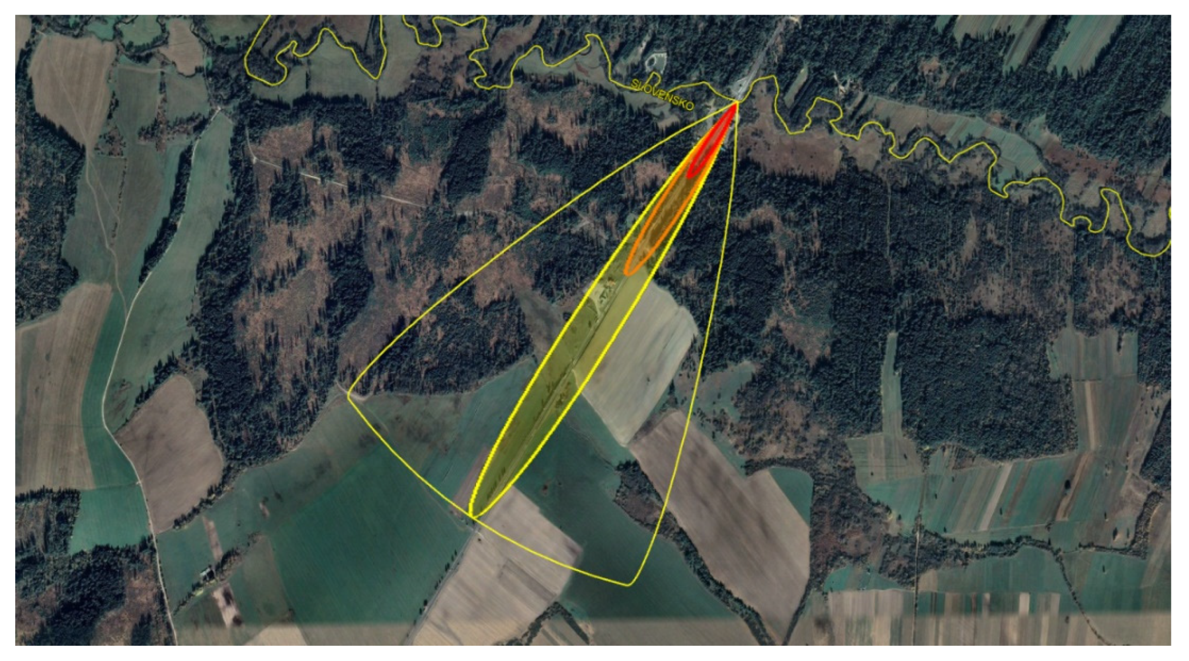
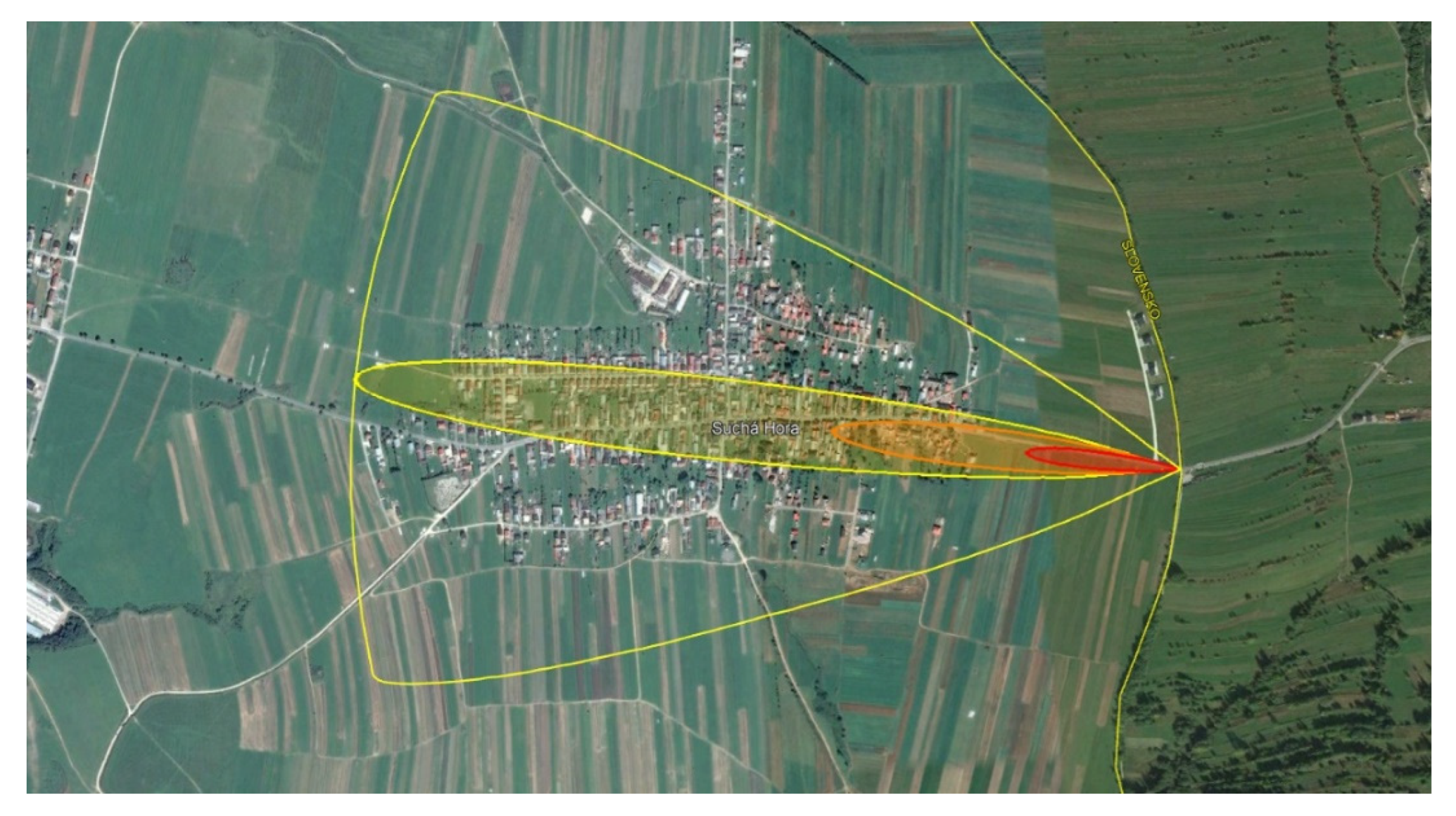
3.1.12. Leakage of a Dangerous Substance at the Suchá Hora Border Crossing
At the Suchá Hora border crossing, a traffic accident occurred due to a violation of road traffic rules. A vehicle carrying a dangerous substance overturned and struck a sharp object. A crack with a diameter of 25 cm formed in the tank, from which ammonia fumes began to disperse to the west, as demonstrated in
Figure 13.
In the red zone with a concentration of 1100 ppm reaching a distance of 311 m, there is a tank driver, a car driver and vehicles travelling on the road leading to the border crossing by the Slovak Republic. The concentration of 1100 ppm ammonia will affect the uninhabited area between the borders and the village Suchá Hora. In the orange zone with a concentration of 160 ppm reaching a distance of 778 m, there are 24 buildings with the character of residential houses and agricultural buildings. In the yellow zone, almost the whole centre of the village of Suchá Hora with 1455 inhabitants will be affected. If the wind directions were directed to the southeast in the simulation, the fumes of the dangerous substance would hit TANAP [
26,
27,
28].
3.2. Map of the Endangered Area Due to the Leakage of a Dangerous Substance in the Border Areas of the Slovak Republic of the Žilina Region
Humans are the worst target in terms of the consequences of exposure to hazardous substances. If the action of dangerous substances causes damage to human health or causes death, it is an irreversible event [
29]. During an examination of the possibility of leakage at individual border crossings, it was found that in almost all investigated situations, the most endangered are those who are on the road near the leakage of a dangerous substance in the wind direction and cannot leave it on their own; for example, if they are trapped in a vehicle as a result of an accident or unconsciousness. Few human dwellings located in the red zone at a concentration of 1100 ppm were endangered in a significant way at the Suchá Hora, Čadca-Milošová-Šance border crossings. For an overview, the results are summarised in
Table 1. Since the area affected by the fumes of the escaped dangerous substance extends, the numbers of inhabitants in the yellow zone with a concentration of 30 ppm will be given only as an indication, according to the population of the affected municipality.
Based on the calculations in the ALOHA programme, the concentration of ammonia in the red zone of AEGL-3 reached the value of 1100 ppm, which is 766.180 mg/m
3. This concentration can lead to death or life-threatening exposure to the human body for 60 min [
28]. Even at concentrations above 200 mg/m
3, a person feels intolerable irritation, chest pain, stomach pain, headache, convulsions, respiratory and circulatory disorders, loss of orientation and renal arrest [
31]. In the orange zone of AEGL-2 with a concentration of 160 ppm, calculated at 114,444 mg/m
3, exposure for 60 min, can cause severe long-term damage to health and put the driver in a state of inability to move independently without the help of another person [
30]. This concentration causes respiratory irritation, tearing and sneezing in humans [
32]. The yellow zone of AEGL-1 with a concentration of 30 ppm, which is 20.896 mg/m
3, is a zone in which a person experiences considerable discomfort and irritation during exposure, but it is only temporary [
30].
People in enclosed spaces are more protected than people who are outdoors. However, the ALOHA CAMEO evaluation programme does not consider it. By closing the windows, switching off the ventilation and using improvised respiratory protective equipment, it is possible to reduce the effects of ammonia fumes on the human body [
31].
In addition to adverse effects on the human body, ammonia vapours can pose a serious threat to nature. Ammonia can change the pH value of aquatic ecological systems and is very toxic to aquatic organisms [
33]. The degree of toxicity also depends on the pH and temperature of the water. Aquatic plants are more resistant to ammonia than aquatic animals. The tolerance of individual ammonia concentrations depends on whether they are invertebrates or fish that are less resistant to its effects. Experiments have demonstrated that a lethal concentration of ammonia for fish is from 0.2 to 2.0 ppm. Even at ammonia concentrations above 0.1 ppm, permanent damage to the body organs of fish occurs even with short-term exposure [
34]. Ammonia is not harmful to vegetation at low concentrations but is damaging at higher concentrations [
35].
The leakage of a dangerous substance will also prevent safe crossing of the border crossing, often without the possibility of bypassing. There is a presumption that the vehicles will be standing in a convoy, and it will be almost impossible to enter the oncoming lane from this convoy and reach safety. It is also assumed that vehicle drivers and their crew will leave the vehicles in a panic and walk on the road, exposing them to the further danger of a collision with moving vehicles. Significant danger is posed by situations where the leakage of a dangerous substance triggers many other adverse events, such as an explosion or fire, as ammonia is a flammable gas which may explode when heated. The scenarios described in this paper would, therefore, be different if the explosion of ammonia vapours and gases were considered together with the occurrence of a fire. However, due to the scale of this work, only the effects of the leakage of the substance itself have been addressed. The results indicate that even a single tank containing ammonia NH3, under favourable meteorological conditions for the dispersion of hazardous substances, poses a significant threat to human, animal and environmental health.
To present the findings concerning the use of border crossings and their usability in the future for the transport of dangerous goods, it is necessary to create a map that will contain all border crossings that are suitable for ADR transport in terms of surface quality and road width. Subsequently, in
Figure 14, the representation of the extent of the endangered area by the leakage of a hazardous substance in the direction of wind flow from 0° to 360° in the territory of the Slovak Republic was completed. The yellow semicircles on the map are marked as the zones endangered by the leakage of a dangerous substance in Slovakia, when the wind flows in all directions. Border crossings are marked with yellow pins.
Names of border crossing points to the left: Makov, Makov–Velké Karlovice–Bílá–Bumbálka, Klokočov–Bílá, Čadca–Milošová–Šance, Svrčinovec–Mosty u Jablunkova, Skalité–Zwardoň–Myto 2, Skalité–Zwardoň–Myto, Novoť–Ujsoly, Oravská Polhora–Korbielów, Bobrov–Wincerówka and Trstená–Chyžné, Suchá Hora.
4. Discussion
Crisis managers use their skills and abilities to create a safe environment. They pay close attention to the preparedness of the population to deal with various extraordinary events, disasters or emergencies [
36]. When focusing on accidents involving the release of hazardous substances, crisis managers use available software that can simulate different accident scenarios. There are many unforeseen events and risks associated with the transport of dangerous goods by road, which can be applied in numerous potential accident scenarios [
37]. There are several software programmes available, including a freely distributable and frequently used Aloha programme. Several authors used it to simulate the leakage of hazardous substances in road transport [
38,
39,
40,
41,
42]. Therefore, it is suitable for crisis managers in public administration who can simulate various leaks with a possible impact on the environment. Such simulations enable taking appropriate measures and planning improvements to the crisis management system.
One of the primary measures is to change the dispersion of the dangerous substance, if possible. Consequently, we must consider that the danger of the dispersion of escaping substances is not limited to their physical-chemical properties but is also affected by various weather conditions [
43,
44,
45]. Modelling with different input data in the ALOHA CAMEO software determined that the inversion has the most significant effect on the dispersion of the hazardous substance under meteorological conditions.
For the same input data, the presence of inversion could increase the range of the vapours and gases escaped up to three times than in the case of the simulation without the presence of inversion. Various smart technologies should also be used for weather prediction [
46,
47]. These technologies should be used by hydrometeorology centres and be provided to crisis managers in public administration. Crisis managers would review this information and inform carriers of dangerous substances in their territory, who could consider a plan for the transport of dangerous substances, if the situation allows. Assuming weather conditions in border areas, crisis managers could contact crisis managers in the neighbouring countries.
The expected number of people endangered by the leakage of hazardous substances in the Slovak Republic is approximately one million. In terms of the Žilina Region, the number is approx. 130,000 people. From the above calculations, it is economically unmanageable to provide special means of individual protection for all these persons. Therefore, every vulnerable person must have the correct habits to respond to emergencies caused by leaks of hazardous substances from vehicles [
5]. Concentrations are relatively fast (for example, in the red zone, the increase to AEGL3 values ranges from 5 to 15 min), but due to the conditions these values will remain there for a short time, a maximum of 20 min, and then disperse. Thus, we can assume that the respective rescue response will not be sufficiently fast to warn the population. Therefore, informing the public about possible threats concerning the transport of dangerous substances in their surroundings is one of the most significant proposals in prevention, to prepare the population for self-help and self-protection.
However, the readiness of the population to deal with emergencies is still at an insufficient level, despite the guaranteed free access to information by Act no. 211/2000 Coll. on free access to information. The need to prepare the population for emergencies is underestimated by the general public and, in some cases, even facilitated [
3]. The use of disaster management scenarios is part of crisis management. Some authors point to urban disaster resilience scenarios [
48]. Other authors using the created scenario solution suggest appropriate assistance in dealing with the consequences of disasters [
49,
50,
51]. Riddele et al. provide several scenarios to assist with more appropriate fund management [
52]. Gibsson et al., in turn, examined eight case studies published in a single issue to find a method to combine and use them appropriately [
53]. Case studies can be used as examples or as a research tool. We can use them to develop the prevention, preparedness and management of disasters and emergencies. It is necessary that the teaching process at universities addresses current issues and prepares experts [
54,
55,
56]. It is possible to reduce their negative impact on the environment concerning the life and health of the population located in vulnerable zones [
2].
There are many approaches to using scenarios and software in disaster management. However, we must adapt the scenarios to the actual environment. In an emergency or a disaster, several different areas can be affected at once. Therefore, the paper focused on specific events in border areas that could affect the Slovak environment. Crisis management has a specific hierarchy in Slovakia. The district office manages the emergency in its territory. If an extraordinary event affects several districts, it is managed by the district office in the seat of the region. To manage disasters properly, you should also prepare scenarios of potential emergencies and disasters that you share with other district authorities in your region. In the paper, we created the maps of possible extraordinary events in the border areas of the entire Žilina region that had never been created before, using scenarios and Aloha software.
The maps can correctly identify the procedures in the event of an accident with the leakage of hazardous substances at borders. Scenarios further develop the issue and discuss it. Similar maps should be created by other Slovak regions and, thus, a unified map for the whole territory would be created. It is also possible to supplement the impact of safe substances on the territory of neighbouring countries, which would reflect all wind directions. This step will allow for a better response and cooperation between countries in dealing with this type of crisis. The results can also form the basis for individual agreements between them, as well as some important documents such as the agreement on cross-border cooperation between neighbours or Regulation (EU) 2021/836 of the European Parliament and of the Council of 20 May 2021 amending Decision no. 1313/2013/EU on a Union Civil Protection Mechanism.
5. Conclusions
In crisis and adverse events, it is more advantageous to take preventive measures than to eliminate their consequences. However, in case of an emergency, it is necessary to take the most appropriate measures to reduce the negative impact on the environment. To support decision making, crisis managers can use simulation tools and create various scenarios to understand the nature of possible risks. In the paper, we identified the border crossings in the territory of the Žilina Region. In the analysis of border crossings at which ADR transport is or might be performed in the future and simulations of the leakage of dangerous substances on their territory, we pointed out that the differences in impacts on population and nature among individual border crossings are fundamentally different. The most significant impacts are the distance of human dwellings from the place of the leakage of hazardous substances, the presence of watercourses and the location of the border crossing in the PLA, or the vicinity of the national park. A significant factor influencing the extent of the threat is the presence of a high-traffic road near the border crossing. In the event of a leak of a dangerous substance, this road would have to be closed, thus paralyzing traffic. There are also people who may be at risk of escaping a dangerous substance on high-traffic roads.
We developed a map of the Žilina Region, in which the zones of the danger of the leakage of hazardous substances at individual border crossings are marked. A graphical representation of all border crossing points through which dangerous goods are or can be transported in the future, with an indication of the extent of the hazardous areas of the dangerous substance vapours and gases escaping, is a tool that can raise the awareness of the general public on the protection of the population against emergencies. Moreover, this map could also be the basis for tactical exercises of the integrated rescue system units. Additionally, such data can reveal what impact an accident near the border would have on the environment of the Slovak Republic. The solved problem creates space for further research with a focus on other regions, the impact abroad and also on the transport of hazardous substances by rail.


 ,
, 


