Evaluation of Automatic Building Detection Approaches Combining High Resolution Images and LiDAR Data


Abstract
:1. Introduction
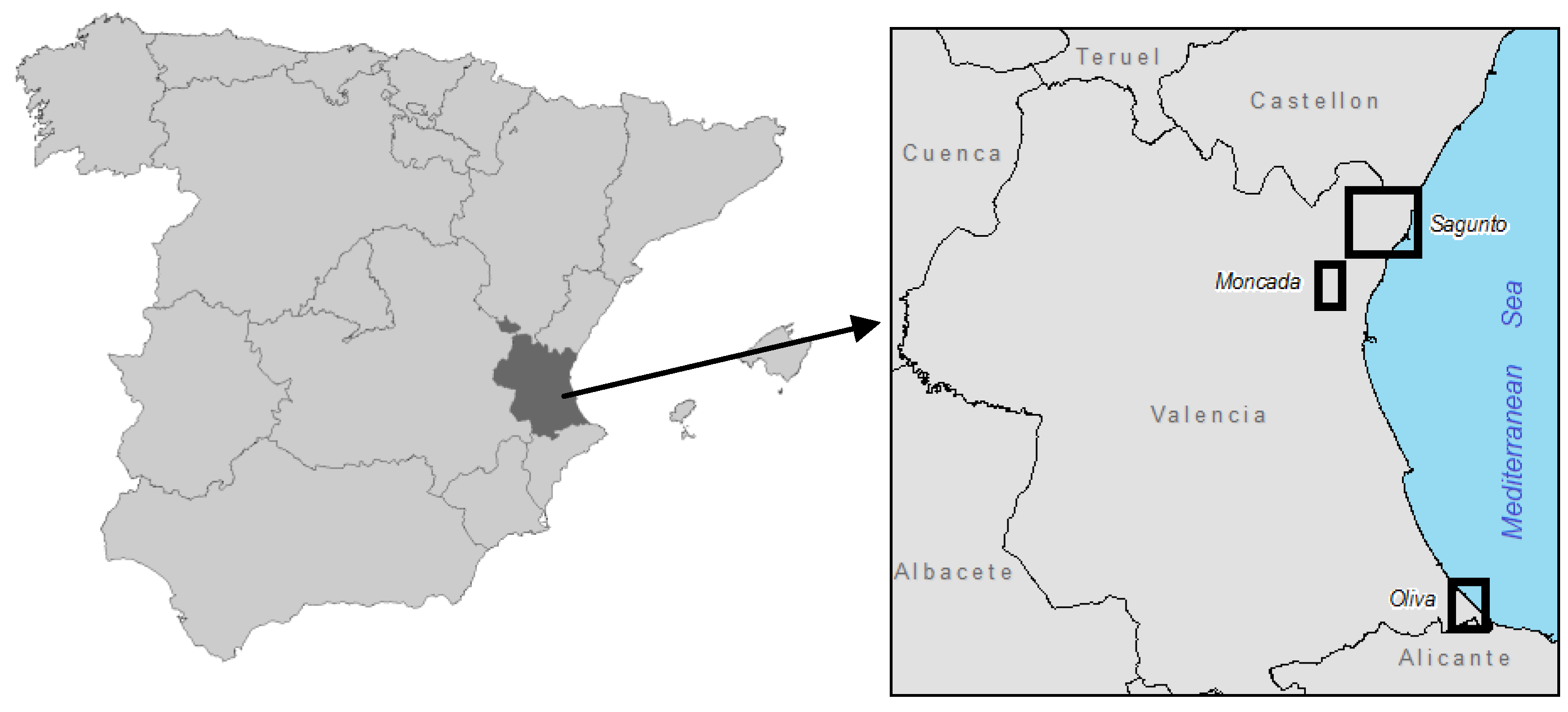
2. Data and Study Area


| Study area | Imagery | LiDAR |
|---|---|---|
| Moncada | QuickBird Acquired: February 2004 Spatial resolution: 0.6 m/pixel Spectral bands: IR, R, G, B | Sensor: Optech ALTM 2033 Acquired: December 2003 Density: 1 point/m2 |
| Oliva | Aerial orthophoto Acquired: June 2006 Spatial resolution: 0.5 m/pixel Spectral bands: IR, R, G | Sensor: Optech ALTM 3025 Acquired: September 2009 Density: 2 points/m2 |
| Sagunto | Aerial orthophoto Acquired: June 2006 Spatial resolution: 0.5 m/pixel Spectral bands: IR, R, G | Sensor: RIEGL LMS-Q680 Acquired: August 2009 Density: 0.5 points/m2 |
3. Methodology
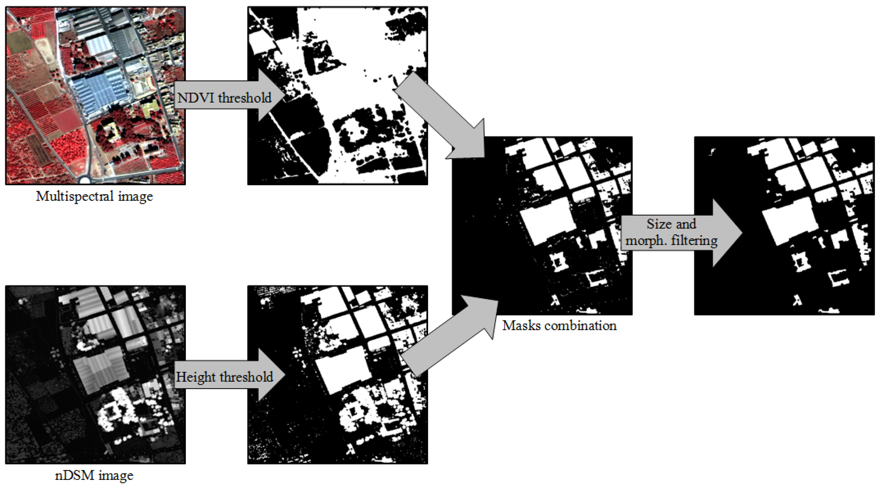
3.1. Thresholding-Based Approach

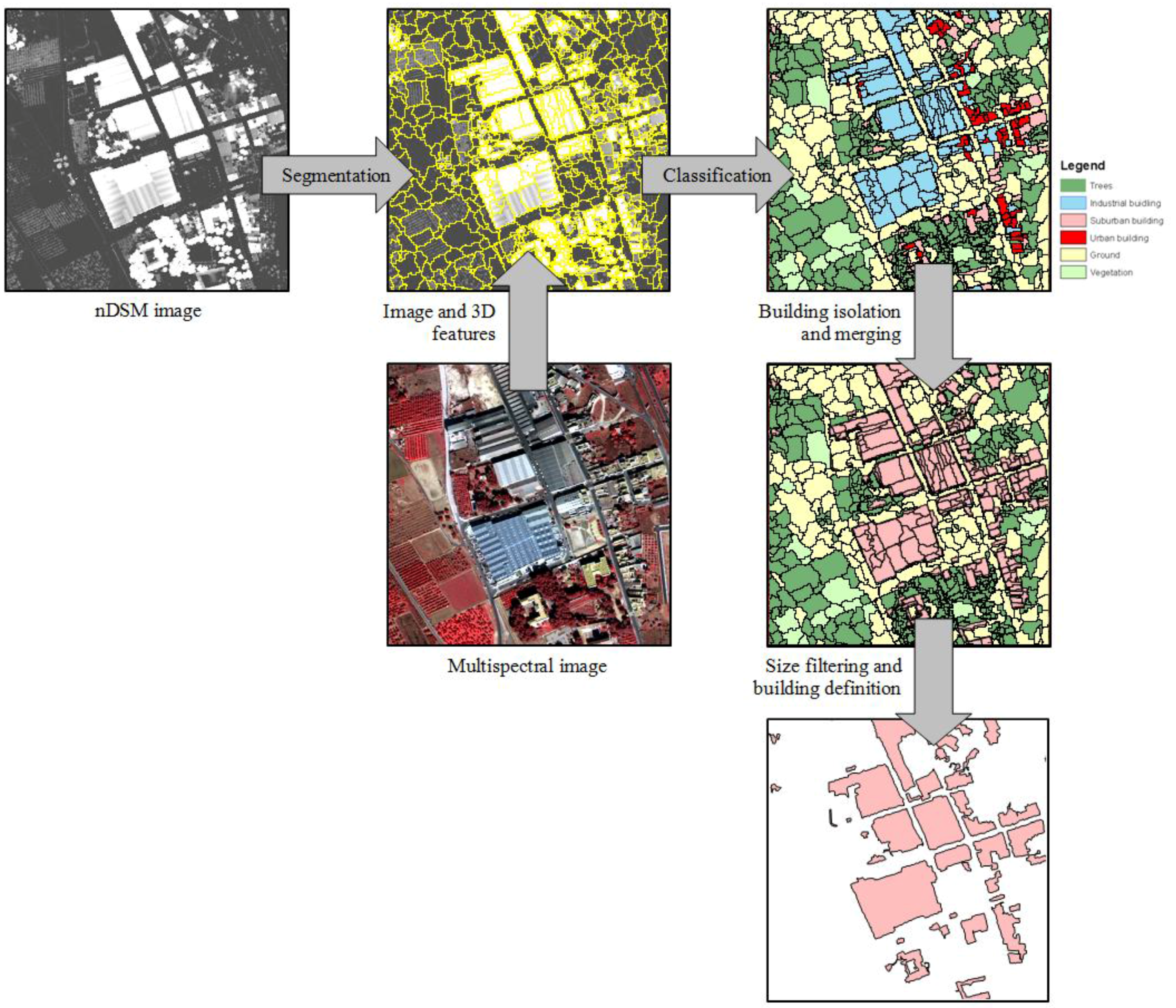
3.2. Object-Based Classification Approach

3.3. Shadow Detection and Contextual Relationships Definition
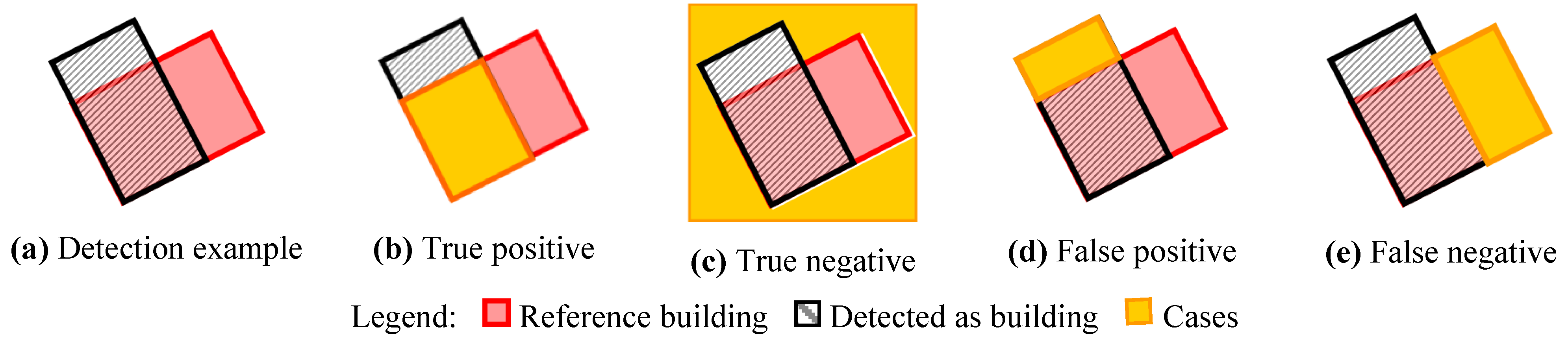
3.4. Quality Assessment
4. Results and Discussion
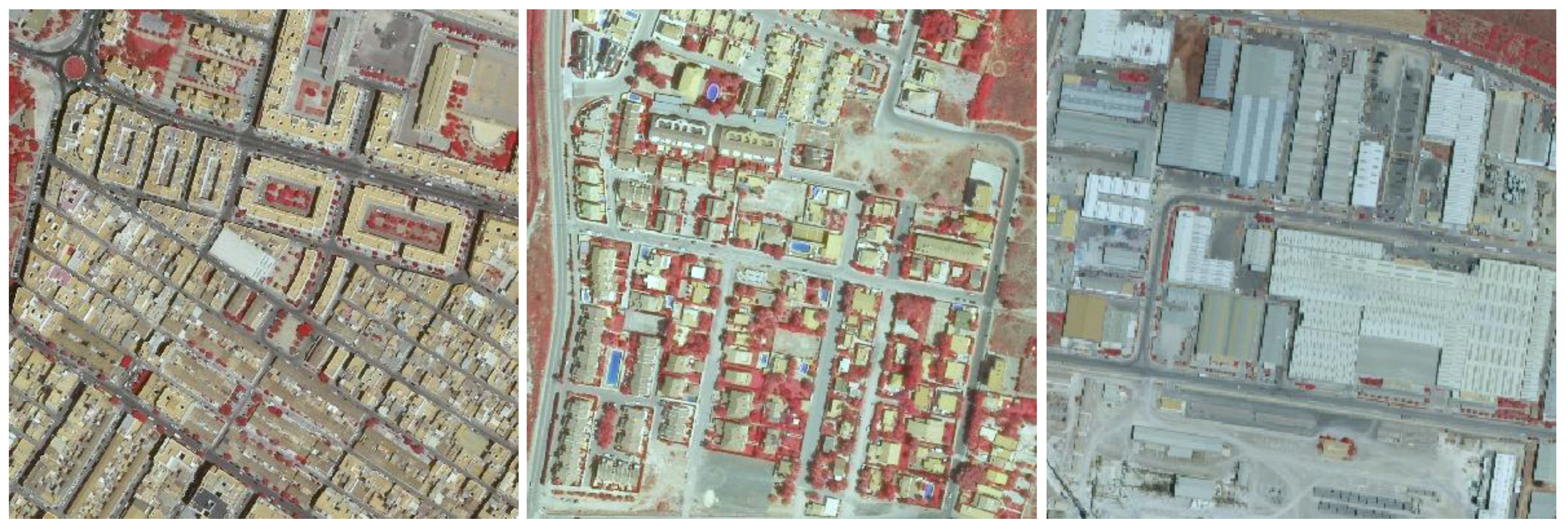
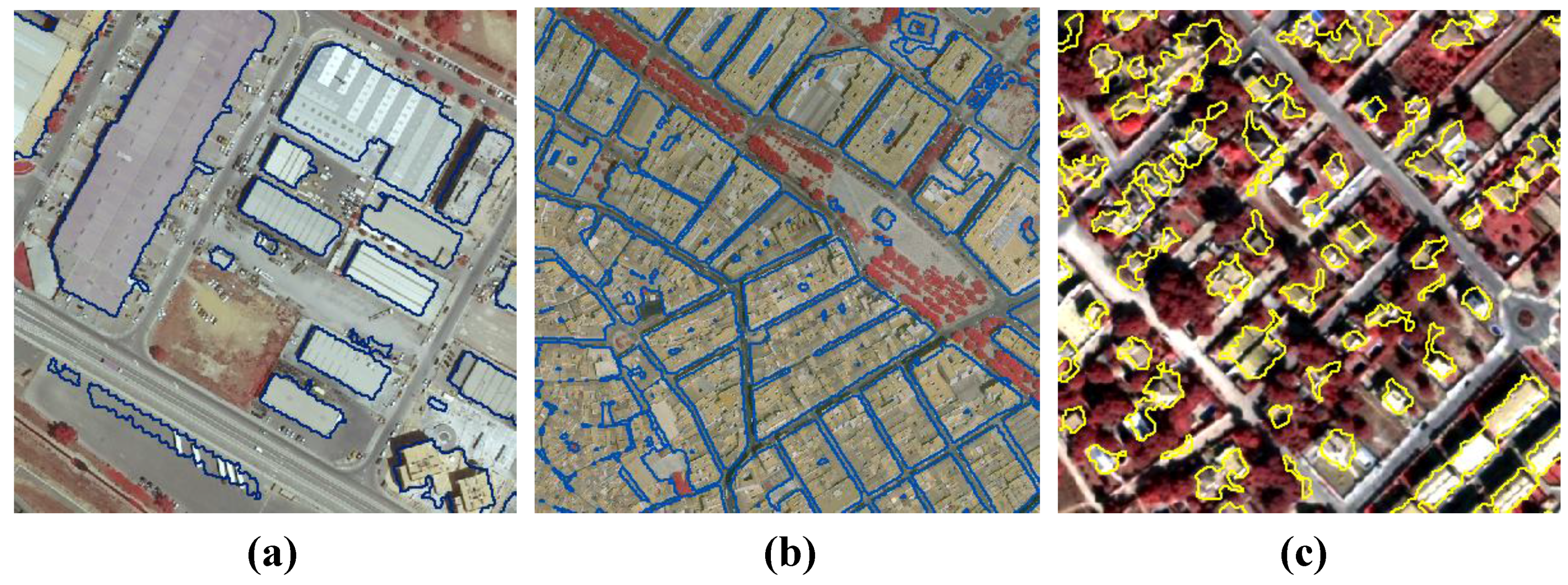
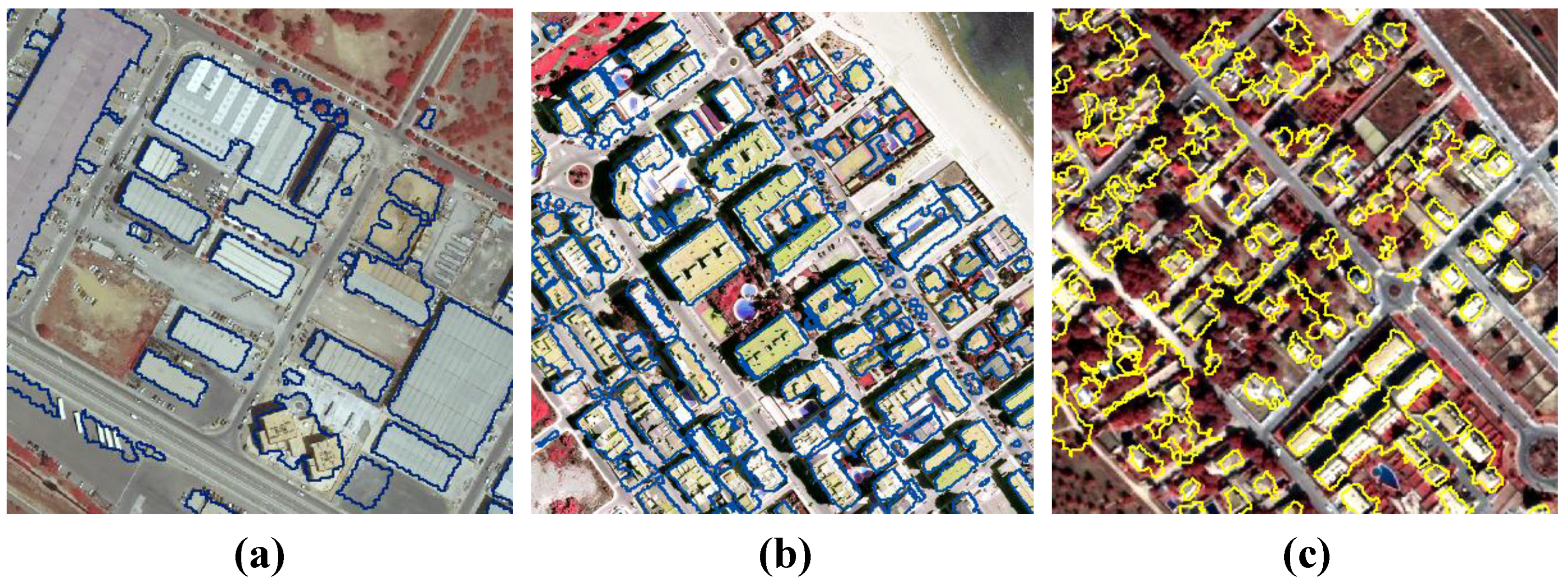
4.1. Evaluation of Building Detection Methods
| Industrial | Urban | Suburban | |||||||
| Moncada | Sagunto | Moncada | Oliva | Sagunto | Moncada | Oliva | Sagunto | ||
| Area-level | Branching factor | 0.06 | 0.09 | 0.12 | 0.08 | 0.11 | 0.37 | 0.11 | 0.15 |
| Miss factor | 0.02 | 0.02 | 0.04 | 0.03 | 0.02 | 0.14 | 0.12 | 0.16 | |
| Detection percentage | 97.7 | 98.2 | 96.5 | 97.2 | 98.1 | 87.8 | 89.1 | 86.3 | |
| Quality percentage | 92 | 90.3 | 86.6 | 90.6 | 88.3 | 66.1 | 81.1 | 76.6 | |
| Object-level | Correctness | 72.4 | 73.3 | 74.3 | 71.9 | 87.2 | 89.8 | 100 | 99.2 |
| Completeness | 100 | 100 | 100 | 100 | 100 | 98.4 | 99.3 | 95 | |
| Study area | Overall accuracy |
|---|---|
| Moncada | 97% |
| Oliva | 95% |
| Sagunto | 98% |
| Industrial | Urban | Suburban | |||||||
| Moncada | Sagunto | Moncada | Oliva | Sagunto | Moncada | Oliva | Sagunto | ||
| Area-level | Branching factor | 0.08 | 0.11 | 0.17 | 0.06 | 0.15 | 0.70 | 0.20 | 0.49 |
| Miss factor | 0.04 | 0.04 | 0.05 | 0.10 | 0.03 | 0.17 | 0.16 | 0.17 | |
| Detection percentage | 96.5 | 96.1 | 95.1 | 90.9 | 97.5 | 85.6 | 86.3 | 85.5 | |
| Quality percentage | 89.6 | 86.8 | 81.7 | 86 | 85.5 | 53.6 | 73.9 | 60.4 | |
| Object-level | Correctness | 59.5 | 50 | 59.5 | 51.6 | 53.8 | 86.6 | 93.1 | 84.1 |
| Completeness | 100 | 96.4 | 96.3 | 100 | 100 | 93 | 99.3 | 95.7 | |
| Industrial | Urban | Suburban | |||||||||||
| Thresh. | Object | Thresh. | Object | Thresh. | Object | ||||||||
| µ | σ | µ | σ | µ | σ | µ | σ | µ | σ | µ | σ | ||
| Area-level | Branching factor | 0.08 | 0.02 | 0.10 | 0.02 | 0.10 | 0.02 | 0.13 | 0.06 | 0.21 | 0.13 | 0.46 | 0.30 |
| Miss factor | 0.02 | 0 | 0.04 | 0 | 0.03 | 0.01 | 0.06 | 0.04 | 0.14 | 0.06 | 0.17 | 0.08 | |
| Detection percentage | 98 | 0.4 | 96.3 | 0.3 | 97.2 | 0.8 | 94.5 | 3.3 | 87.7 | 5.2 | 85.8 | 6.7 | |
| Quality percentage | 91.2 | 1.2 | 88.2 | 2 | 88.5 | 2 | 84.4 | 2.4 | 74.6 | 11.1 | 62.6 | 16.1 | |
| Object-level | Correctness | 72.9 | 0.6 | 54.8 | 6.7 | 77.8 | 8.2 | 55.0 | 4.1 | 96.3 | 5.6 | 87.9 | 21.1 |
| Completeness | 100 | 0 | 98.2 | 2.5 | 100 | 0 | 98.8 | 2.1 | 97.6 | 2.3 | 96.0 | 3.9 | |
| Industrial | Urban | Suburban | |||||||||||
| Without shadows | With shadows | Without shadows | With shadows | Without shadows | With shadows | ||||||||
| µ | σ | µ | σ | µ | σ | µ | σ | µ | σ | µ | σ | ||
| Area-level | Branching factor | 0.08 | 0.02 | 0.07 | 0.01 | 0.10 | 0.02 | 0.10 | 0.02 | 0.21 | 0.13 | 0.20 | 0.14 |
| Miss factor | 0.02 | 0 | 0.02 | 0 | 0.03 | 0.01 | 0.03 | 0.01 | 0.14 | 0.06 | 0.30 | 0.13 | |
| Detection percentage | 98 | 0.4 | 98 | 0.4 | 97.2 | 0.8 | 96.8 | 0.3 | 87.7 | 5.2 | 77.7 | 8.3 | |
| Quality percentage | 91.2 | 1.2 | 91.4 | 0.9 | 88.5 | 2 | 88.4 | 1.4 | 74.6 | 11.1 | 66.8 | 2.1 | |
| Object-level | Correctness | 72.9 | 0.6 | 76.8 | 2.5 | 77.8 | 8.2 | 83.4 | 11.2 | 96.3 | 5.6 | 97.7 | 3.2 |
| Completeness | 100 | 0 | 100 | 0 | 100 | 0 | 99.1 | 1.5 | 97.6 | 2.3 | 82.5 | 11 | |
| Industrial | Urban | Suburban | |||||||||||
| Without shadows | With shadows | Without shadows | With shadows | Without shadows | With shadows | ||||||||
| µ | σ | µ | σ | µ | σ | µ | σ | µ | σ | µ | σ | ||
| Area-level | Branching factor | 0.10 | 0.02 | 0.09 | 0.01 | 0.13 | 0.06 | 0.12 | 0.06 | 0.46 | 0.30 | 0.45 | 0.31 |
| Miss factor | 0.04 | 0 | 0.04 | 0.00 | 0.06 | 0.04 | 0.06 | 0.04 | 0.17 | 0.08 | 0.20 | 0.08 | |
| Detection percentage | 96.3 | 0.3 | 96.3 | 0.3 | 94.5 | 3.3 | 94.5 | 3.3 | 85.8 | 6.7 | 83.2 | 7.1 | |
| Quality percentage | 88.2 | 2 | 88.7 | 1.3 | 84.4 | 2.4 | 84.6 | 2.5 | 62.6 | 16.1 | 61.5 | 16.2 | |
| Object-level | Correctness | 54.8 | 6.7 | 57.3 | 3.2 | 55.0 | 4.1 | 59.3 | 1.0 | 87.9 | 21.1 | 92.7 | 21.0 |
| Completeness | 98.2 | 2.5 | 98.2 | 2.5 | 98.8 | 2.1 | 98.8 | 2.1 | 96.0 | 3.9 | 91.7 | 3.6 | |
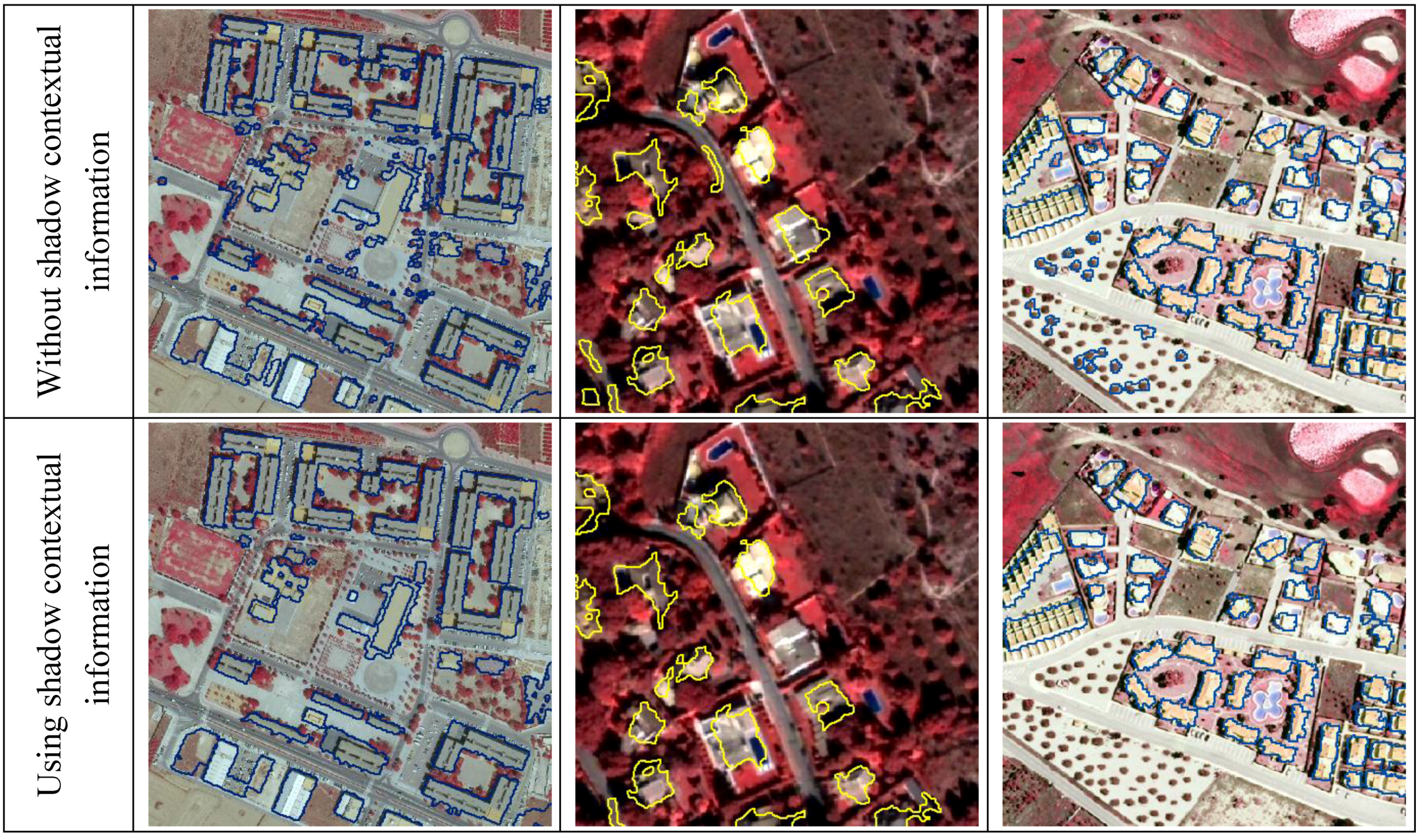
4.2. Assessment of Contextual Information Derived from Shadows
5. Conclusions
Acknowledgements
References
- Mayer, H. Automatic object extraction from aerial imagery—A survey focusing on buildings. Comput. Vis. Image Understand. 1999, 74, 138–149. [Google Scholar] [CrossRef]
- Wei, Y.; Zhao, Z.; Song, J. Urban Building Extraction from High-Resolution Satellite Panchromatic Image Using Clustering and Edge Detection. In Proceedings of IEEE International Geoscience and Remote Sensing Symposium, Honolulu, HI, USA, 20–24 September 2004; Volume 7, pp. 2008–2010.
- Kim, T.; Muller, J. Development of a graph based approach for building detection. Image Vis. Comput. 1999, 17, 3–14. [Google Scholar] [CrossRef]
- Donnay, J.P.; Barnsley, M.J.; Longley, P.A. Remote sensing and urban analysis. In Remote Sensing and Urban Analysis; Donnay, J.P., Barnsley, M.J., Longley, P.A., Eds.; Taylor and Francis: London, UK, 2001; pp. 3–18. [Google Scholar]
- Sohn, G.; Dowman, I. Extraction of buildings from high resolution satellite data. In Automated Extraction of Man-Made Object from Aerial and Space Images (III); Baltsavias, E., Gruen, A., Van Gool, L., Eds.; Balkema Publishers: Lisse, The Netherlands, 2001; pp. 345–355. [Google Scholar]
- Irvin, R.B.; McKeown, D.M., Jr. Methods for exploiting the relationship between buildings and their shadows in aerial imagery. IEEE Trans. Syst. Man Cybern. 1989, 19, 1564–1575. [Google Scholar] [CrossRef]
- Lin, C.; Huertas, A.; Navatia, R. Detection of Buildings Using Perceptual Grouping and Shadows. In Proceedings of 1994 IEEE Computer Society Conference on Computer Vision Pattern Recognition, Seattle, WA, USA, 21–23 June 1994; pp. 62–69.
- Lin, C.; Nevatia, R. Building detection and description from a single intensity image. Comput. Vis. Image Understand. 1998, 72, 101–121. [Google Scholar] [CrossRef]
- Katartzis, A.; Sahli, H. A stochastic framework for the identification of building rooftops using a single remote sensing image. IEEE Trans. Geosci. Remote Sens. 2008, 46, 259–271. [Google Scholar] [CrossRef]
- Kim, T.; Lee, T.Y.; Lim, Y.J.; Kim, K.O. The Use of Voting Strategy for Building Extraction from High Resolution Satellite Images. In Proceedings of the IEEE International Geoscience and Remote Sensing Symposium, Seoul, Korea, 25–29 July 2005; pp. 1269–1272.
- Cui, S.Y.; Yam, Q.; Liu, Z.J.; Li, M. Building Detection and Recognition from High Resolution Remotely Sensed Imagery. In Proceedings of the XXIst ISPRS Congress, Beijing, China, 3–11 July 2008; Volume XXXVII, Part B3b. pp. 411–416.
- Mayunga, S.D.; Zhang, Y.; Coleman, D.J. Semi-Automatic Building Extraction Utilizing Quickbird Imagery. In Proceedings of the ISPRS Working Groups III/4-5 and IV/3: “CMRT 2005”, Vienna, Austria, 29–30 August 2005; Volume XXXVI, Part 3/W24. pp. 131–136.
- Theng, L.B. Automatic building extraction from satellite. Eng. Lett. 2006, 13, EL_13_3_5. [Google Scholar]
- Ahmady, S.; Ebadi, H.; Zouj, M.J.V.; Moghaddam, H.A. Automatic Building Extraction from High Resolution Satellite Images Using Active Contour MDE. In Proceedings of the XXIst ISPRS Congress, Beijing, China, 3–11 July 2008; Volume XXXVII, Part B3b. pp. 453–456.
- Ge, Q.Z.; Li, Q.; Ling, Z.C.; Hui, X.X.; Zhang, G. Stochastic Motion and the Level Set Method in Semi-Automatic Building Detection. In Proceedings of the XXIst ISPRS Congress, Beijing, China, 3–11 July 2008; Volume XXXVII, Part B3b. pp. 431–434.
- Ok, A.O. Robust Detection of Buildings from a Single Color Aerial Image. In Proceedings of GEOBIA 2008, Calgary, AB, Canada, 5–8 August 2008; Volume XXXVII, Part 4/C1. p. 6.
- Olsen, B.P. Automatic Change Detection for Validation of Digital Map Databases. In Proceedings of the XXth ISPRS Congress, Istanbul, Turkey, 12–23 July 2004; Volume XXXV, Part B2. pp. 569–574.
- Shan, J.; Lee, D.S. Generalization of Building Polygons Extracted from IKONOS Imagery. In Proceedings of the ISPRS Commision IV Symposium “Geospatial Theory, Processing and Applications”, Ottawa, ON, Canada, 9–12 July 2002; Volume XXXIV, Part 4. pp. 286–290.
- Lee, D.S.; Shan, J.; Bethel, J. Class-guided building extraction from IKONOS imagery. Photogramm. Eng. Remote Sensing 2003, 69, 143–150. [Google Scholar] [CrossRef]
- Lefévre, S.; Weber, J.; Sheeren, D. Automatic Building Extraction in VHR Images using Advanced Morphological Operators. In Proceedings of the Urban Remote Sensing Joint Event, Paris, France, 11–13 April 2007; pp. 1–5.
- Stassopoulou, A.; Caelli, T. Building detection using Bayesian networks. Int. J. Pattern Recog. Artif. Intell. 2000, 14, 715–733. [Google Scholar] [CrossRef]
- Kundsen, T.; Nielsen, A.A. Detection of Buildings Through Multivariate Analysis of Spectral, Textural, and Shape Based Features. In Proceedings of IEEE International Geoscience and Remote Sensing Symposium, Honolulu, HI, USA, 20–24 September 2004; Volume 7, pp. 2830–2833.
- Duan, J.; Prinet, V.; Lu, H. Building Extraction in Urban Areas from Satellite Images Using GIS Data as Prior Information. In Proceedings of IEEE International Geoscience and Remote Sensing Symposium, Honolulu, HI, USA, 20–24 September 2004; Volume 7, pp. 4762–4764.
- Marangoz, A.M.; Oruç, M.; Büyüksalih, G. Object-Oriented Image Analysis and Semantic Network for Extracting the Roads and Buildings From Ikonos Pan-sharpened Images. In Proceedings of the XXth ISPRS Congress, Istanbul, Turkey, 12–23 July 2004; Volume XXXV, Part B3. p. 4.
- Müller, S.; Zaum, D.W. Robust Building Detection in Aerial Images. In Proceedings of the ISPRS Working Group III/4-5 and IV/3: “CMRT 2005”, Vienna, Austria, 29–30 August 2005; Volume XXXVI, Part 3/W24. pp. 143–148.
- Liu, W.; Prinet, V. Building Detection from High-Resolution Satellite Image Using Probability Model. In Proceedings of the IEEE International Geoscience and Remote Sensing Symposium, Seoul, Korea, 25–29 July 2005; pp. 3888–3891.
- Lari, Z.; Ebadi, H. Automatic Extraction of Building Features from High Resolution Satellite Images Using Artificial Neural Networks. In Proceedings of the ISPRS Working Group I/5 and IV/3: “High Resolution Earth Imaging for Geospatial Information”, Hannover, Germany, 29 May–1 June 2007; Volume XXXVI, Part 1/W51. p. 6.
- Sumer, E.; Turker, M. Building Detection from High-Resolution Satellite Imagery Using Adaptive Fuzzy-Genetic Approach. In Proceedings of GEOBIA 2008, Calgary, AB, Canada, 5–8 August 2008; Volume XXXVIII, Part 4/C1. p. 6.
- Bellman, C.; Shortis, M. Building recognition using wavelet analysis and support vector machines. In Spatial Knowledge without Boundaries; Lees, B., Ed.; Spatial Sciences Institute: Canberra, Australia, 2003. [Google Scholar]
- Lin, Y.; Zhang, S.; Xie, F.; Chen, Y. The Construction of Anti-Symmetrical Wavelet and Building Extraction from Remote Sensing Imagery. In Proceedings of the XXIst ISPRS Congress, Beijing, China, 3–11 July 2008; Volume XXXVII, Part B3b. pp. 467–472.
- Vu, T.T.; Matsuoka, M.; Yamazaki, F. Shadow Analysis in Assisting Damage Detection due to Earthquakes from Quickbird Imagery. In Proceedings of the XXth ISPRS Congress, Istanbul, Turkey, 12–23 July 2004; Volume XXXV, pp. 607–610.
- Hofmann, P.; Strobl, J.; Blaschke, T.; Kux, H. Detecting Informal Settlements from QuickBird Data in Rio de Janeiro Using an Object Based Approach. In Proceedings of the Conference on Object-Based Image Analysis (OBIA06), Salzburg, Austria, 4–5 July 2006; Volume XXXVI, Part 4/C42. p. 6.
- Tian, J.; Wang, J.; Shi, P. Urban Building Boundary Extraction from IKONOS Imagery. In Proceedings of The 25th Canadian Symposium on Remote Sensing, Montreal, QC, Canada, 14–16 October 2003; p. 6.
- Liu, Z.J.; Wang, J.; Liu, W.P. Building Extraction from High Resolution Imagery Based on Multi-Scale Object Oriented Classification and Probabilistic Hough Transform. In Proceedings of the IEEE International Geoscience and Remote Sensing Symposium, Seoul, Korea, 25–29 July 2005; pp. 2250–2253.
- Li, H.Y.; Wang, H.Q.; Ding, C.B. A New Solution of Automatic Building Extraction in Remote Sensing Images. In Proceedings of the IEEE International Geoscience and Remote Sensing Symposium, Denver, CO, USA, 31 July–4 August 2006; pp. 3790–3793.
- L’Homme, S.; Weber, C.; He, D.C.; Morin, D.; Puissant, A. Building Extraction from Very High Spatial Resolution Image. In Proceedings of the XXth ISPRS Congress, Istanbul, Turkey, 12–23 July 2004; Volume XXXV, Part B3. pp. 921–925.
- Shackelford, A.K.; Davis, C.H.; Wang, X. Automated 2-D Building Footprint Extraction from High-Resolution Satellite Multispectral Imagery. In Proceedings of the IEEE International Geoscience and Remote Sensing Symposium, Honolulu, HI, USA, 20–24 September 2004; Volume 7, pp. 1996–1999.
- Jin, X.; Davis, C.H. Automated building extraction from high-resolution satellite imagery in urban areas using structural, contextual, and spectral information. EURASIP J. Appl. Signal Process. 2005, 14, 2196–2206. [Google Scholar] [CrossRef]
- Klaric, M.; Scott, G.; Shyu, C.R.; Davis, C.H. Automated Object Extraction through Simplification of the Differential Morphological Profile for High-Resolution Satellite Imagery. In Proceedings of the IEEE International Geoscience and Remote Sensing Symposium, Seoul, Korea, 25–29 July 2005; pp. 1265–1268.
- Shyu, R.; Scott, G.; Klaric, M.; Davis, C.H.; Palaniappan, K. Automatic Object Extraction from Full Differential Morphological Profile in Urban Imagery for Efficient Object Indexing and Retrievals. In Proceedings of the 3rd International Symposium Remote Sensing and Data Fusion Over Urban Areas, Tempe, AZ, USA, 14–16 March 2005; p. 6.
- Kim, Z.W.; Netavia, R. Uncertain reasoning and learning for feature grouping. Comput. Vis. Image Undestand. 1999, 73, 278–288. [Google Scholar] [CrossRef]
- Scanlan, J.M.; Chabries, D.M.; Christiansen, R.W. A shadow detection and removal algorithm for 2-D images. IEEE Trans. Acoust. Speech Signal Process. 1990, 4, 2057–2060. [Google Scholar]
- Madhavan, B.B.; Tachibana, K.; Sasagawa, T.; Okada, H.; Shimozuma, Y. Automatic Extraction of Shadow Regions in High-resolution Ads40 Images. In Proceedings of the XXth ISPRS Congress, Istanbul, Turkey, 12–23 July 2004; Volume XXXV, Part B3. pp. 808–810.
- Dare, P.M. Shadow analysis in high-resolution satellite imagery of urban areas. Photogramm. Eng. Remote Sensing 2005, 71, 169–177. [Google Scholar] [CrossRef]
- Tsai, J.D. Automatic Shadow Detection and Radiometric Restoration on Digital Aerial Images. In Proceedings of the IEEE International Geoscience and Remote Sensing Symposium, Toulouse, France, 21–25 July 2003; pp. 732–733.
- Ambrosio, G.; Arévalo, V.; González, J.; Valdés, J. Detección de Sombras en Imágenes de Satélite de Alta Resolución QuickBird. In Proceedings of the XXVII Jornadas de Automática, Almería, Spain, 6–9 September 2006; pp. 1306–1313.
- Weidner, U.; Förstner, W. Towards automatic building extraction from high-resolution digital elevation models. ISPRS J. Photogramm. Remote Sens. 1995, 50, 38–49. [Google Scholar] [CrossRef]
- Cord, M.; Declercq, D. Three-dimensional building detection and modeling using a statistical approach. IEEE Trans. Image Process. 2001, 10, 715–723. [Google Scholar] [CrossRef] [PubMed]
- Vestri, C.; Devernay, F. Using Robust Methods for Automatic Extraction of Buildings. In Proceedings of the International Conference on Computer Vision and Pattern Recognition, Kauai, HI, USA, 8–14 December 2001; pp. 208–213.
- Jordan, M.; Cord, M.; Belli, T. Building Detection from High Resolution Digital Elevation Models in Urban Areas. In Proceedings of the ISPRS Commission III Symposium: “Photogrammetric Computer Vision”, Graz, Austria, 9–13 September 2002; Volume XXXIV, Part 3B. pp. 96–99.
- Champion, N. 2D Building Change Detection from High Resolution Aerial Images and Correlation Digital Surface Models. In Proceedings of PIA07-Photogrammetric Image Analysis, Munich, Germany, 19–21 September 2007; Volume XXXVI, Part 3/W49A. pp. 197–202.
- Karsli, F.; Kahya, O. Building Extraction from Laser Scanning Data. In Proceedings of the XXIst ISPRS Congress, Beijing, China, 3–11 July 2008; Volume XXXVII, Part B3b. pp. 289–294.
- Tan, G.; Shibasaki, R. A Research for the Extraction of 3D Urban Building by Using Airborne Laser Scanner Data. In Proceedings of the 23rd Asian Conference on Remote Sensing, Kathmandu, Nepal, 25–29 November 2002; p. 5.
- Hofmann, A.D.; Maas, H.G.; Streilein, A. Knowledge-Based Building Detection Based on Laser Scanner Data and Topographic Map Information. In Proceedings of the ISPRS Commission III Symposium: “Photogrammetric Computer Vision”, Graz, Austria, 9–13 September 2002; Volume XXXIV, Part 3A. pp. 169–174.
- Cho, W.; Jwa, Y.S.; Chang, H.J.; Lee, S.H. Pseudo-Grid Based Building Extraction Using Airborne LIDAR Data. In Proceedings of the XXth ISPRS Congress, Istanbul, Turkey, 12–23 July 2004; Volume XXXV, PartB3. pp. 378–381.
- Ma, R. DEM generation and building detection from lidar data. Photogramm. Eng. Remote Sensing 2005, 71, 847–854. [Google Scholar] [CrossRef]
- Miliaresis, G.; Kokkas, N. Segmentation and object-based classification for the extraction of the building class from LIDAR DEMs. Comput. Geosci. 2007, 33, 1076–1087. [Google Scholar]
- Vosselman, G.; Gorte, B.G.H.; Sithole, G. Change Detection for Updating Medium Scale Maps Using Laser Altimetry. In Proceedings of the XXth ISPRS Congress, Istanbul, Turkey, 12–23 July 2004; Volume XXXV, Part B3. pp. 207–212.
- Ekhtari, N.; Sahebi, M.R.; Valadan Zoej, M.J.; Mohammadzadeh, A. Automatic Building Detection from LIDAR Point Cloud Data. In Proceedings of the XXIst ISPRS Congress, Beijing, China, 3–11 July 2008; Volume XXXVII, Part B4. pp. 473–477.
- Lai, X.; Wan, Y.; Wei, W. A Flow to Generate DEM and Segment Building in Urban Areas from LiDAR Data. In Proceedings of the XXIst ISPRS Congress, Beijing, China, 3–11 July 2008; Volume XXXVII, Part B3b. pp. 149–152.
- Zhang, K.; Yan, J.; Chen, S.C. Automatic construction of buildings footprints from airborne LIDAR data. IEEE Trans. Geosci. Remote Sens. 2006, 44, 2523–2533. [Google Scholar] [CrossRef]
- Tse, R.O.C.; Gold, C.M.; Kidner, D.B. Building Reconstruction Using LIDAR Data. In Proceedings of the ISPRS Working Group IV/1: “Dynamic and Multi-dimensional GIS”, Urumchi, China, 28–29 August 2007; Volume XXXVI, Part 4-W54. pp. 121–126.
- Wan, C.K.; Hsu, P.H. Building Detection and Structure Line Extraction from Airborne LiDAR Data. In Proceedings of the XXIst ISPRS Congress, Beijing, China, 3–11 July 2008; Volume XXXVII, Part B3b. pp. 267–272.
- Lafarge, F.; Descombes, X.; Zerubia, J.; Pierrot-Deseilligny, M. Automatic building extraction from DEMs using an object approach and application to the 3D-city modelling. ISPRS J. Photogramm. Remote Sens. 2008, 63, 365–381. [Google Scholar] [CrossRef]
- Kokubu, K.; Kohiyama, M.; Umemura, F.; Yamazaki, F. Automatic Detection of Building Properties from Aerial Photographs Using Color and 3D Configuration. In Proceedings of the 22nd Asian Conference on Remote Sensing, Singapore, 5–9 November 2001; p. 6.
- Chen, L.C.; Teo, T.A.; Shao, Y.C.; Lai, Y.C.; Rau, J.Y. Fusion of LIDAR Data and Optical Imagery for Building Modeling. In Proceedings of the XXth ISPRS Congress, Istanbul, Turkey, 12–23 July 2004; Volume XXXV, PartB4. pp. 732–737.
- Matikainen, L.; Hyyppä, J.; Kaartinen, H. Automatic Detection of Changes from Laser Scanner and Aerial Image Data for Updating Building Maps. In Proceedings of the XXth ISPRS Congress, Istanbul, Turkey, 12–23 July 2004; Volume XXXV, PartB2. pp. 434–439.
- Teo, T.A.; Chen, L.C. Object-Based Building Detection from LiDAR Data and High Resolution Satellite Imagery. In Proceedings of the 25th Asian Conference on Remote Sensing, Chiang Mai, Thailand, 22–26 November 2004; p. 6.
- Koc San, D.; Turker, M. Automatic Building Detection and Delineation from High Resolution Space Images Using Model Based Approach. In Proceedings of the ISPRS Working Groups I/5 and I/6I Workshop: “Topographic Mapping from Space”, Ankara, Turkey, 14–16 February 2006; Volume XXXVI, Part 1/W41. p. 6.
- Matikainen, L.; Kaartinen, H.; Hyyppä, J. Classification Tree Based Building Detection from Laser Scanner and Aerial Image Data. In Proceedings of the ISPRS Working Groups III/3, III/4, V/3 and VIII/11: “Lasser Scanning 2007 and SilviLaser 2007”, Espoo, Finland, 12–14 September, 2007; Volume XXXVI, Part 3/W52. pp. 280–287.
- Li, H.; Gu, H.; Han, Y.; Yang, J. Fusion of High-Resolution Aerial Imagery and LIDAR Data for Object-Oriented Urban Land-Cover Classification Based on SVM. In Proceedings of the ISPRS Working Group IV/1: “Dynamic and Multi-dimensional GIS”, Urumchi, China, 28–29 August 2007; Volume XXXVI, Part 4/W54. pp. 179–184.
- Oczipka, M.; Bucher, T.; Trosset, A. Maping and Updating Maps in Dense Urban Regions Using High Resolution Digital Airborne Imagery, Surface Models and Object-Based Classification. In Proceedings of the XXIst ISPRS Congress, Beijing, China, 3–11 July 2008; Volume XXXVII, Part B7. pp. 551–556.
- Vögtle, T.; Steinle, E. 3D Modelling of Buildings Using Laser Scanning and Spectral Information. In Proceedings of the XIXth ISPRS Congress, Amsterdam, The Netherlands, 16–22 July 2000; Volume XXXIII, Part B3. pp. 927–934.
- Ferreira, J.; Bernardino, A. Acquisition of 3D Regular Prismatic Models in Urban Environments from DSM and Orthoimages. In Proceedings of the Symposium on Computational Modeling of Objects Represented in Images: Fundamentals, Methods and Applications, Coimbra, Portugal, 20–21 October 2006; p. 6.
- Yu, B.; Liu, H.; Zhang, L.; Wu, J. An Object-Based Two-Stage Method for a Detailed Classification of Urban Landscape Components by Integrating Airborne LiDAR and Color Infrared Image Data: A Case Study of Downtown Houston. In Proceedings of the Join Urban Remote Sensing Event, Shanghai, China, 20–22 May 2009; p. 6.
- Yu, B.; Liu, H.; Wu, J.; Hu, Y.; Zhang, L. Automated derivation of urban building density information using airborne LiDAR data and object-based method. Landscape Urban Plan 2010, 98, 210–219. [Google Scholar] [CrossRef]
- Vu, T.T.; Matsuoka, M.; Yamazaki, F. LiDAR Signature to Update Japanese Building Inventory Database. In Proceedings of the 25th Asian Conference on Remote Sensing, Chiang Mai, Thailand, 22–26 November 2004; pp. 624–629.
- Rottensteiner, F.; Trinder, J.; Clode, S.; Kubic, K. Building Dectection Using LIDAR Data and Multispectral Images. In Proceedings of Digital Image Computing: Techniques and Applications, Sydney, Australia, 10–12 December 2003; pp. 673–682.
- Rottensteiner, F.; Trinder, J.; Clode, S.; Kubik, K. Building Detection by Dempster-Shafer Fusion of LIDAR Data and Multispectral Aerial Imagery. In Proceedings of the 17th International Conference on Pattern Recognition, Cambridge, UK, 23–26 August 2004; pp. 339–342.
- Vozikis, G.; Jansa, J. Advantages and Disadvantages of the Hough Transformation in the Frame of Automated Building Extraction. In Proceedings of the XXIst ISPRS Congress, Beijing, China, 3–11 July 2008; Volume XXXVII, Part B3b. pp. 719–724.
- Cheng, L.; Gong, J.; Chen, X.; Han, P. Building Boundary Extraction from High Resolution Imagery and LiDAR Data. In Proceedings of the XXIst ISPRS Congress, Beijing, China, 3–11 July 2008; Volume XXXVII, Part B3b. pp. 693–698.
- Paparoditis, N. Building detection and reconstruction from mid- and high-resolution aerial imagery. Comput. Vis. Image Understand. 1998, 72, 122–142. [Google Scholar] [CrossRef]
- Guo, T.; Yasuoka, Y. Snake-Based Approach for Building Extraction from High-Resolution Satellite Images and Height Data in Urban Areas. In Proceedings of the 23rd Asian Conference on Remote Sensing, Kathmandu, Nepal, 25–29 November 2002; p. 6.
- Estornell, J.; Ruiz, L.A.; Velázquez-Martí, B.; Hermosilla, T. Analysis of the factors affecting LiDAR DTM accuracy in a steep shrub area. Int. J. Digit. Earth 2010. [Google Scholar] [CrossRef]
- Ruiz, L.A.; Recio, J.A.; Fernández-Sarría, A.; Hermosilla, T. A feature extraction software tool for agricultural object-based image analysis. Comput. Electron. Agric. 2011, 76, 284–296. [Google Scholar] [CrossRef]
- Haralick, R.M.; Shanmugan, K.; Dinstein, I. Texture features for image classification. IEEE Trans. Syst. Man Cybern. 1973, 3, 610–621. [Google Scholar] [CrossRef]
- Sutton, R.N.; Hall, E.L. Texture measures for automatic classification of pulmonary disease. IEEE Trans. Comput. 1972, 21, 667–676. [Google Scholar] [CrossRef]
- Quinlan, J.R. C4.5: Programs for Machine Learning; Morgan Kaufmann: San Mateo, CA, USA, 1993. [Google Scholar]
- Freund, Y. Boosting a weak learning algorithm for majority. Inf. Comput. 1995, 121, 256–285. [Google Scholar] [CrossRef]
- McGlone, J.C.; Shufelt, J.A. Projective and Object Space Geometry for Monocular Building Extraction. In Proceedings of Computer Vision and Pattern Recognition, Seattle, WA, USA, 21–23 June 1994; pp. 54–61.
- Shufelt, J.A. Performance evaluation and analysis of monocular building extraction from aerial imagery. IEEE Trans. Pattern Anal. 1999, 21, 311–326. [Google Scholar] [CrossRef]
- Shan, J.; Lee, D.S. Quality of building extraction from IKONOS imagery. J. Survey. Eng. 2005, 131, 27–32. [Google Scholar] [CrossRef]
- Champion, N.; Matikainen, L.; Rottensteiner, F.; Liang, X.; Hyyppä, J. A Test of 2D Building Change Detection Methods: Comparison, Evaluation and Perspectives. In Proceedings of the XXIst ISPRS Congress, Beijing, China, 3–11 July 2008; Volume XXXVII, Part B4. pp. 297–303.
© 2011 by the authors; licensee MDPI, Basel, Switzerland. This article is an open access article distributed under the terms and conditions of the Creative Commons Attribution license (http://creativecommons.org/licenses/by/3.0/).
Share and Cite
Hermosilla, T.; Ruiz, L.A.; Recio, J.A.; Estornell, J. Evaluation of Automatic Building Detection Approaches Combining High Resolution Images and LiDAR Data. Remote Sens. 2011, 3, 1188-1210. https://doi.org/10.3390/rs3061188
Hermosilla T, Ruiz LA, Recio JA, Estornell J. Evaluation of Automatic Building Detection Approaches Combining High Resolution Images and LiDAR Data. Remote Sensing. 2011; 3(6):1188-1210. https://doi.org/10.3390/rs3061188
Chicago/Turabian StyleHermosilla, Txomin, Luis A. Ruiz, Jorge A. Recio, and Javier Estornell. 2011. "Evaluation of Automatic Building Detection Approaches Combining High Resolution Images and LiDAR Data" Remote Sensing 3, no. 6: 1188-1210. https://doi.org/10.3390/rs3061188
APA StyleHermosilla, T., Ruiz, L. A., Recio, J. A., & Estornell, J. (2011). Evaluation of Automatic Building Detection Approaches Combining High Resolution Images and LiDAR Data. Remote Sensing, 3(6), 1188-1210. https://doi.org/10.3390/rs3061188