1. Introduction
Forest resources are indispensable for ecological conservation, carbon stock assessment, and spatial land management. Consequently, acquiring fine-scale forest information is a fundamental prerequisite for forest inventory and monitoring efforts [
1,
2].
The advancement of unmanned aerial vehicle (UAV)-based remote sensing has provided a powerful tool for this task [
3]. UAV imagery, characterized by its high spatial resolution and flexible acquisition capabilities, offers significant advantages for forest recognition over complex terrains, thereby furnishing reliable data support for fine-scale forest segmentation [
4,
5].
In parallel, deep learning-based semantic segmentation has revolutionized the interpretation of remote sensing imagery. Established architectures such as U-Net, DeepLabv3+, and PSPNet have demonstrated promising results in various land-cover and multi-class segmentation tasks [
6,
7,
8,
9].
However, a critical challenge in UAV-based forest mapping is cross-regional generalization. Forest landscapes exhibit pronounced spatial heterogeneity across regions, with substantial variations in stand structure, species composition, spectral–textural characteristics, and background elements (e.g., bare soil, shadows, and roads). These variations lead to complex and inconsistent forest–non-forest boundaries, often resulting in severe performance degradation when segmentation models trained in one region are directly applied to another, revealing the limited ability of many existing approaches to handle domain shifts [
10].
This challenge is further compounded by the current limitations of UAV forest datasets. Publicly available benchmarks remain scarce and typically cover only a narrow range of forest types and environmental conditions, which restricts systematic evaluation of model robustness across structurally diverse forest scenes. As a result, developing and validating segmentation models with reliable cross-regional generalization capability remains an open and underexplored research problem.
Recent studies have emphasized that in-domain accuracy alone is often insufficient to assess the practical reliability of segmentation models under real-world deployment. Instead, stability under cross-domain or cross-regional transfer—particularly under variations in acquisition conditions and scene composition—has been shown to be more indicative of field robustness. Multi-dataset benchmarking in vegetation and agricultural monitoring has demonstrated that models with more consistent cross-domain performance can be more reliable in practice than those achieving higher peak accuracy on a single dataset [
11]. This perspective further motivates the need for explicit cross-regional evaluation in UAV-based forest segmentation.
For example, the Forest Inspection Dataset for Aerial Semantic Segmentation and Depth Estimation provides densely annotated semantic labels for UAV imagery acquired in forested environments, with an emphasis on varying illumination conditions and viewing angles [
12]. However, this dataset combines real and synthetic data and is not specifically designed for cross-regional semantic segmentation benchmarking across structurally distinct forest types.
Furthermore, while lightweight segmentation models present an ideal trade-off between computational efficiency and accuracy—making them particularly suitable for operational forest monitoring—their performance has not been comprehensively validated under varying conditions of forest structural complexity and spatial heterogeneity [
13,
14]. The PP-LiteSeg architecture, noted for its efficiency, serves as an excellent baseline. Our proposed attention-refined versions, V01 and V02, are designed to enhance its feature representation. Yet, a key unanswered question is: how do these structural refinements perform when confronted with the diverse forest compositions and complexities encountered across different geographic regions? The interplay between model architecture and regional forest characteristics may critically influence segmentation outcomes, necessitating a targeted evaluation on multi-regional datasets.
To address these gaps, this study focuses on enhancing cross-regional generalization for UAV forest segmentation. We select two representative sites in Yunnan Province, China, with contrasting forest structures: the structurally regular, plantation-dominated Huayuan Forest Farm (Kunming) and the naturally heterogeneous, mixed forests of Longhai Township (Qujing). We construct a unified, high-quality UAV forest segmentation dataset from these regions. Using this dataset, we conduct a systematic experimental analysis with two core objectives: (1) to evaluate and compare the proposed PP-LiteSeg variants (V01 and V02) against classical CNN baselines (U-Net, DeepLabv3+, PSPNet) as well as representative lightweight and transformer-based models (BiSeNetV2 and SegFormer-B0) under both single-region and mixed-region settings; and (2) to explicitly assess cross-regional generalization under domain shift via bidirectional transfer experiments (train on one region and directly test on the other without fine-tuning), and to elucidate how different model architectures respond to varying degrees of spatial heterogeneity and forest-type regularity.
The main contributions of this work are twofold:
Dataset Contribution: We construct and publicly release two novel UAV forest segmentation datasets that capture fundamentally distinct forest structural types: a structurally regular artificial plantation (Huayuan Forest Farm) and a naturally heterogeneous mixed forest (Longhai Township). By employing a semi-automatic annotation pipeline based on EISeg, we significantly enhanced labeling efficiency and, more critically, achieved high contour consistency in forest boundary delineation. This process ensures the reliability and quality of the provided benchmark data for evaluating cross-regional generalization.
Methodological and Empirical Contribution: We conduct a comprehensive, cross-regional evaluation of semantic segmentation models, with a dedicated focus on our proposed attention-refined PP-LiteSeg networks (V01 and V02). Through systematic experiments on both individual and mixed-region datasets, we not only quantify the superior generalization performance of our models but also precisely characterize their tailored strengths. The experiments substantiate that V01 achieves exceptional boundary precision in regular plantation forests, whereas V02 exhibits remarkable robustness and adaptability across complex, heterogeneous natural landscapes. This provides clear, scenario-specific guidance for model selection in practical forest mapping applications.
2. Related Work
2.1. Semantic Segmentation Methods for Remote Sensing Imagery
As a key technique in the interpretation of remote sensing imagery, semantic segmentation has achieved significant progress in recent years, driven by advances in deep learning methods [
15]. The Fully Convolutional Network (FCN) was the first to achieve end-to-end pixel-level prediction, laying the foundation for deep learning-based semantic segmentation approaches [
16,
17]. Building upon this paradigm, representative CNN-based models such as U-Net, PSPNet, and DeepLabv3+ were subsequently proposed. By introducing encoder–decoder architectures, multi-scale context fusion strategies, and dilated convolution mechanisms, these models significantly enhanced feature representation and object recognition capability in complex scenes [
18,
19].
Despite their success in remote sensing tasks such as land cover classification and building extraction, applying general-purpose semantic segmentation models to forest imagery remains challenging. Forest scenes are characterized by dense and repetitive textures, complex canopy structures, fuzzy forest–non-forest boundaries, and strong illumination variations, which hinder accurate boundary delineation, fine-detail preservation, and reliable segmentation in weak-texture regions [
20]. Moreover, many mainstream segmentation models are associated with large parameter scales and relatively slow inference, limiting their practicality for high-resolution UAV imagery and large-area forest mapping.
In response to these challenges, recent studies have increasingly focused on lightweight and attention-based segmentation architectures that aim to balance accuracy, efficiency, and robustness. BiSeNetV2 adopts a dual-path design consisting of a detail branch and a semantic branch, enabling effective preservation of spatial details while maintaining low computational complexity, and has therefore been widely used as a representative lightweight CNN-based baseline [
21]. In parallel, transformer-based models such as SegFormer introduce self-attention mechanisms to capture long-range dependencies and global contextual information through hierarchical transformer encoders and lightweight decoders [
22]. While these approaches demonstrate promising efficiency or global modeling capability, their effectiveness and generalization robustness in heterogeneous forest environments—especially under cross-regional transfer scenarios—have not been systematically investigated. Consequently, there remains a clear motivation to explore segmentation frameworks that are both lightweight and adaptive to diverse forest scene structures.
2.2. UAV-Based Forest Segmentation
With the rapid development of UAV remote sensing technology, UAV imagery—featuring high spatial resolution, high mobility, and low cost—has become an important data source for forest resource surveys. In global forest monitoring and classification, the accurate delineation of forest–non-forest boundaries serves as a fundamental task for forest classification, area estimation, and ecological monitoring [
23,
24]. However, traditional manual interpretation and ground surveys are not only inefficient but also highly susceptible to variations in terrain, vegetation density, and human subjectivity, making them inadequate for the requirements of fine-scale forest monitoring.
In contrast, UAV imagery can capture more detailed and complete surface information in mountainous areas, regions with mixed forest types, and locations with limited accessibility, providing reliable support for automated forest segmentation [
25]. However, existing UAV forest datasets are generally limited in scale and often focus on a single forest type or representative sample area, making it difficult to fully reflect the diversity and complexity of real-world forest environments [
26]. In practical applications, semantic segmentation models often face complex combinations of land cover objects, diverse forest type structures, and strong noise interference, which place higher demands on their generalization capability. Therefore, constructing datasets that encompass diverse forest structures and conducting systematic performance evaluations across multiple scenarios are of significant research and practical value for advancing the operationalization of automated forest segmentation technologies.
2.3. Baseline Models
To systematically evaluate the segmentation performance of different architectures across diverse forest type structures and multi-scenario UAV imagery, this study selects a set of representative semantic segmentation models as baselines, including U-Net, PSPNet, DeepLabv3+, BiSeNetV2, and SegFormer-B0 [
7,
9,
19,
21,
22]. These models cover mainstream architectural paradigms ranging from classical CNN-based designs to recent lightweight and transformer-based approaches, providing comprehensive and reliable comparative references for evaluating the proposed PP-LiteSeg variants.
U-Net adopts a typical encoder–decoder architecture and effectively integrates shallow and deep features through skip connections, giving the model a notable advantage in boundary detail restoration. As a result, it has been widely used in medical imaging and fine-grained remote sensing segmentation tasks [
27]. PSPNet introduces the Pyramid Pooling Module (PPM), which aggregates contextual information at multiple spatial scales to enhance global scene understanding; however, it may struggle with irregular and fragmented boundaries [
28]. DeepLabv3+ further expands the receptive field using dilated convolutions and the Atrous Spatial Pyramid Pooling (ASPP) module, enabling richer high-level semantic representation in complex scenes, albeit at the cost of increased architectural complexity and reduced inference efficiency.
In addition to these classical CNN-based baselines, BiSeNetV2 is included as a representative lightweight segmentation network designed for efficient feature fusion and low computational overhead. Its bilateral architecture, consisting of a detail branch and a semantic branch with guided aggregation, enables effective preservation of spatial details while maintaining a compact model structure [
21]. SegFormer-B0 is selected as a representative transformer-based baseline, which employs a hierarchical transformer encoder and a lightweight decoder to model long-range dependencies and global contextual information in a parameter-efficient manner [
22].
Overall, U-Net, PSPNet, DeepLabv3+, BiSeNetV2, and SegFormer-B0 respectively represent fine-grained boundary restoration, multi-scale context aggregation, high-receptive-field semantic modeling, lightweight real-time CNN design, and attention-based global context modeling. Using these models as baselines allows a comprehensive evaluation of the performance and cross-regional generalization capability of the improved PP-LiteSeg series from multiple architectural perspectives.
2.4. Related Work on the Improved PP-LiteSeg
Recent studies have explored various strategies to improve lightweight semantic segmentation networks, aiming to enhance feature representation while preserving computational efficiency. As a representative lightweight segmentation framework, PP-LiteSeg achieves a favorable balance between inference efficiency and segmentation accuracy through a streamlined backbone, multi-scale context fusion, and an efficient decoding strategy, making it suitable for high-resolution imagery such as UAV data [
29]. Existing improvements to PP-LiteSeg and similar lightweight models have mainly focused on urban scenes and structured environments, where object boundaries are relatively regular and background interference is limited.
However, the effectiveness of these lightweight enhancement strategies in remote sensing imagery—particularly UAV-based forest scenes—has not yet been systematically investigated [
30]. Forest environments exhibit substantially different characteristics compared with urban scenarios, including dense and repetitive textures, fuzzy forest–non-forest boundaries, strong illumination variation, and complex background composition. These factors pose significant challenges to feature discrimination and model stability, especially under cross-regional transfer conditions.
Motivated by these limitations, this study investigates the challenges of applying lightweight semantic segmentation models to UAV-based forest imagery under strong scene heterogeneity and cross-regional domain shifts. In particular, maintaining robust performance across structurally regular plantation forests and highly heterogeneous natural forests remains an open problem, which is further examined in the subsequent sections.
3. Materials and Methods
3.1. Datasets
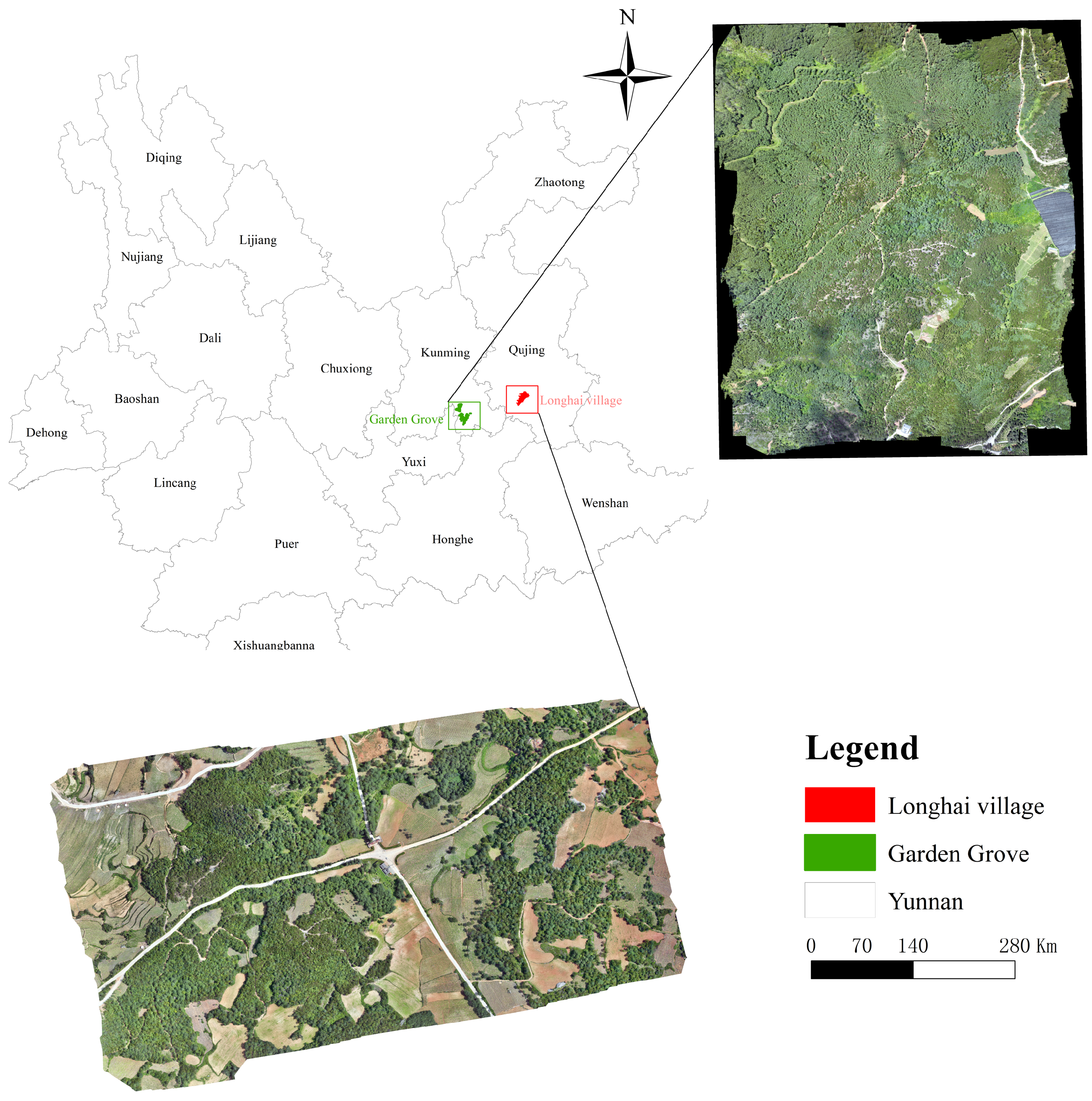
The dataset used in this study was collected from two regions in Yunnan Province, China: Huayuan Forest Farm in Yiliang County, Kunming City, and Longhai Township in Luliang County, Qujing City.
Figure 1 illustrates the spatial locations of the two study areas within Yunnan Province and the corresponding UAV image acquisition ranges, providing spatial context for the subsequent experiments on forest segmentation and cross-regional generalization.
The two regions exhibit significant differences in terrain variation, vegetation cover types, canopy structures, and background object complexity, offering a representative basis for evaluating the performance of UAV-based forest imagery under varying spatial heterogeneity conditions. The Huayuan Forest Farm area is subject to intensive forest management, characterized by regular stand structures, uniformly arranged tree canopies, and clearly defined object boundaries. According to the 2023 “One Map” data from the Yunnan Provincial Forest Resources Survey, this area is predominantly covered by plantations (approximately 74%), and the structural stability of the forest further reinforces its overall spatial regularity.
In contrast, the Longhai Township area contains more diverse vegetation types, including shrubs, bare land, and farmland, with significant variations in lighting and shadow conditions. The forest–non-forest boundaries in this region are more irregular and complex. Survey results indicate that this region is dominated by natural forests (approximately 75%), characterized by high texture variation and strong heterogeneity, which significantly distinguishes it from the plantation-dominated environment of the Huayuan Forest Farm.
The dataset constructed in this study has been publicly released, aiming to serve as a high-quality, reproducible benchmark for UAV-based forest segmentation, algorithm evaluation, and cross-regional model generalization research.
3.1.1. Data Acquisition and Preprocessing
We acquired UAV imagery for both regions using a DJI Mavic 3M platform. The platform is equipped with a dual-camera system: a 20-megapixel RGB camera (5280 × 3956 pixels) and a 5-megapixel multispectral camera (2592 × 1944 pixels). The multispectral sensor captures four specific bands: green (560 nm ± 16 nm), red (650 nm ± 16 nm), red-edge (730 nm ± 16 nm), and near-infrared (860 nm ± 26 nm). All flights were conducted under clear skies and low wind conditions to minimize atmospheric and illumination variability, thereby ensuring high radiometric consistency and geometric fidelity in the raw imagery. Following acquisition, we processed all images using Pix4D software to perform aerial triangulation and orthorectification, generating high-resolution, georeferenced orthophoto mosaics for each study area.
3.1.2. Dataset Composition and Partitioning
From the processed imagery, we constructed a total of 300 image samples, which were organized into three distinct datasets to support different experimental objectives:
Huayuan Dataset: 150 samples from the plantation forest area.
Longhai Dataset: 150 samples from the natural heterogeneous forest area.
Combined Dataset: The union of the above, containing all 300 samples from both regions.
These datasets were designed to support multiple complementary evaluation objectives. Experiments conducted on the Huayuan Forest Farm or the Longhai Township datasets individually focus on assessing model performance under consistent regional conditions. Cross-regional generalization is explicitly evaluated by training models on one region and directly testing them on the other, without any overlap in orthomosaics or spatial coverage. In addition, experiments on the combined dataset are used to examine overall model robustness when confronted with mixed forest structures and environmental variability.
For the within-region experiments and the mixed-dataset evaluation, image patches were partitioned into training, validation, and test subsets using a consistent 8:1:1 ratio to ensure stable optimization and fair comparison across different models. We emphasize that these patch-level splits are intended for controlled performance comparison rather than for strict spatial generalization assessment, which is instead addressed through the cross-regional experimental setting.
3.1.3. Patch Generation and Quality Control
The extremely high resolution of the original orthophotos (e.g., exceeding 10,000 pixels per side) made them unsuitable for direct input into deep learning models. Therefore, we applied a unified patch-splitting strategy. Each large orthomosaic was subdivided into non-overlapping patches of 1024 × 1024 pixels.
Specifically, for the Huayuan Forest Farm area, two orthophotos (resolutions: 10,229 × 13,264 pixels and 9768 × 23,709 pixels) were split, yielding 108 and 207 initial patches, respectively. For the Longhai Township area, two orthophotos (resolutions: 15,713 × 17,619 pixels and 22,291 × 18,910 pixels) were split, yielding 255 and 378 initial patches.
We then implemented a rigorous manual and automatic quality inspection to filter out patches that were incomplete, blurry, or contained insufficient informational content (e.g., large areas of pure cloud or shadow). This filtering process resulted in a final, curated set of 150 high-quality patches for each regional dataset.
This standardized approach to patch generation and quality control allowed us to preserve the fine spatial details present in the UAV imagery while conforming to the input constraints of segmentation models, ultimately enhancing both training efficiency and the stability of model convergence.
3.2. Annotation Method
To generate the high-precision ground truth required for model training and evaluation, we adopted a semi-automatic annotation workflow based on the interactive deep learning tool EISeg [
31]. Specifically, the annotation process utilized the pre-trained interactive segmentation model hrnet18_ocr64_cocolvis.pdparams, which is based on an HRNet-18 backbone with an Object-Contextual Representation (OCR) module and was pre-trained on the COCO and LVIS datasets. The semantic segmentation task was defined as a binary classification problem, with each pixel labeled as either “Forest” or “Non-forest”.
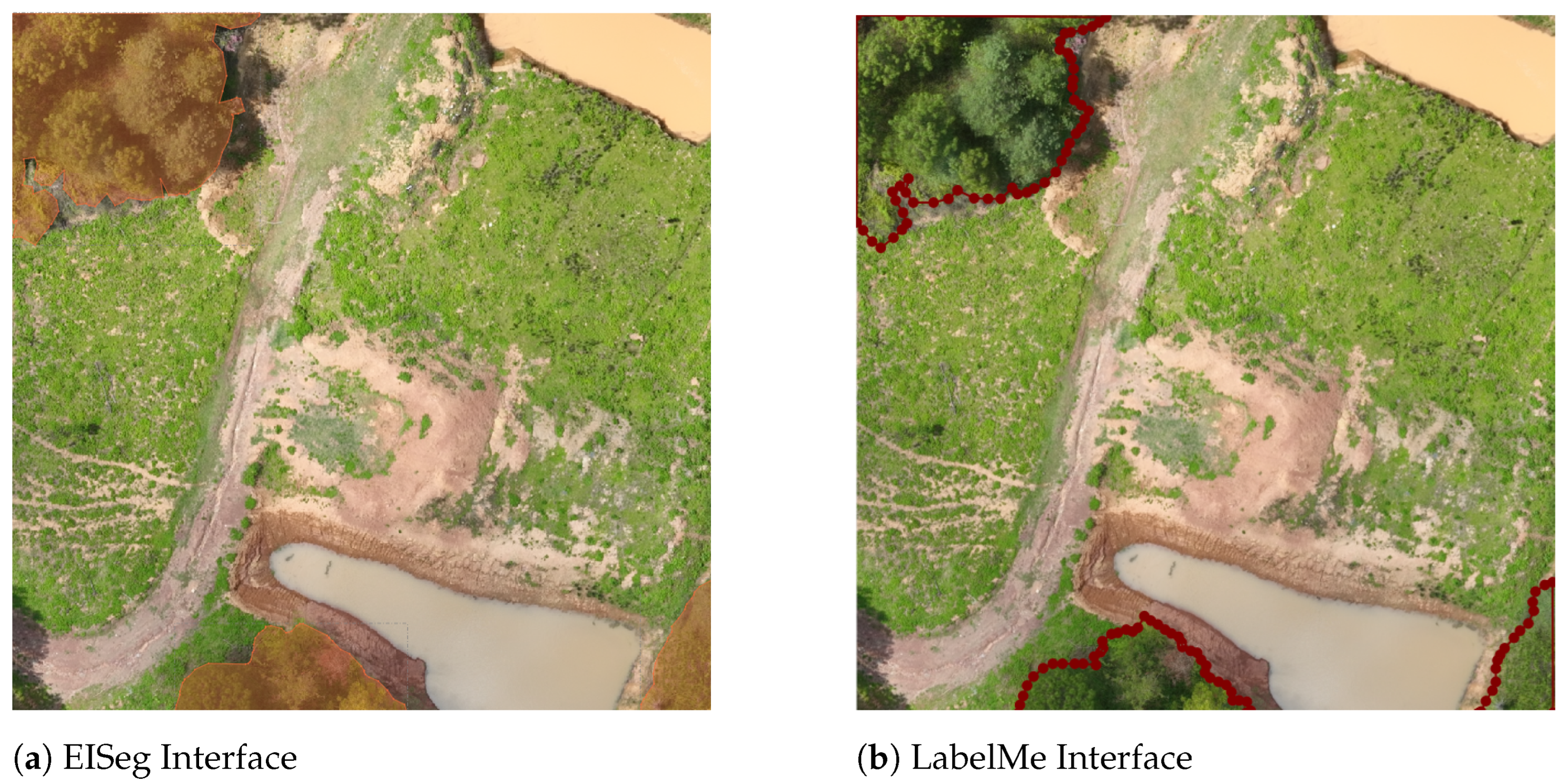
The core advantage of EISeg over conventional manual annotation tools (e.g., LabelMe) lies in its efficiency and consistency, particularly for complex UAV imagery [
32]. As illustrated in
Figure 2, EISeg operates on an interactive paradigm: annotators provide a minimal set of positive and negative clicks on the image, upon which a pre-trained model generates an initial segmentation mask. This proposal is then efficiently refined by the annotator. This workflow stands in contrast to the purely manual process in LabelMe, which requires time-consuming point-by-point polygon delineation and is more susceptible to subjective errors and inconsistency in complex scenes.
To provide an illustrative comparison of annotation efficiency, we conducted a controlled test under comparable annotation settings. For annotating a representative UAV image patch to a similar accuracy standard, the EISeg-based semi-automatic workflow typically required about one-third of the annotation time needed by the traditional manual LabelMe approach. This observation reflects an approximate, empirical comparison intended to indicate relative annotation efficiency, rather than a statistically comprehensive evaluation.
3.3. Improved PP-LiteSeg Network Architecture
To address the challenges of segmenting high-resolution UAV forest imagery, we build upon the lightweight PP-LiteSeg architecture, chosen for its efficient balance between accuracy and inference speed—a practical requirement for processing UAV data. Our enhancements focus on three aspects tailored to forest scenes: a streamlined backbone for efficient feature extraction, improved multi-scale context fusion, and a compact decoder for high-resolution reconstruction.
We employ the STDC (Short-Term Dense Concatenate) network series as the encoder backbone. Its design incorporates short-term dense connections within each stage, concatenating outputs from adjacent convolutional layers. This enhances local feature representation while maintaining architectural simplicity. In our experiments, we utilize two variants: the lighter STDC1 and the more expressive STDC2, allowing us to explore the trade-off between model capacity and architectural compactness across different forest environments.
To facilitate reproducibility, the key configurations of the STDC backbones adopted in this study are summarized in
Table 1. Specifically, PP-LiteSeg-T employs the STDC1 backbone with decoder channel sizes of 32, 64, and 128, providing a compact architectural configuration with reduced parameter scale. In contrast, PP-LiteSeg-B utilizes the STDC2 backbone with decoder channel sizes of 64, 96, and 128, offering enhanced feature representation capability at a moderate increase in model complexity. This design allows a systematic investigation of the trade-off between model compactness and segmentation accuracy under varying forest structural conditions.
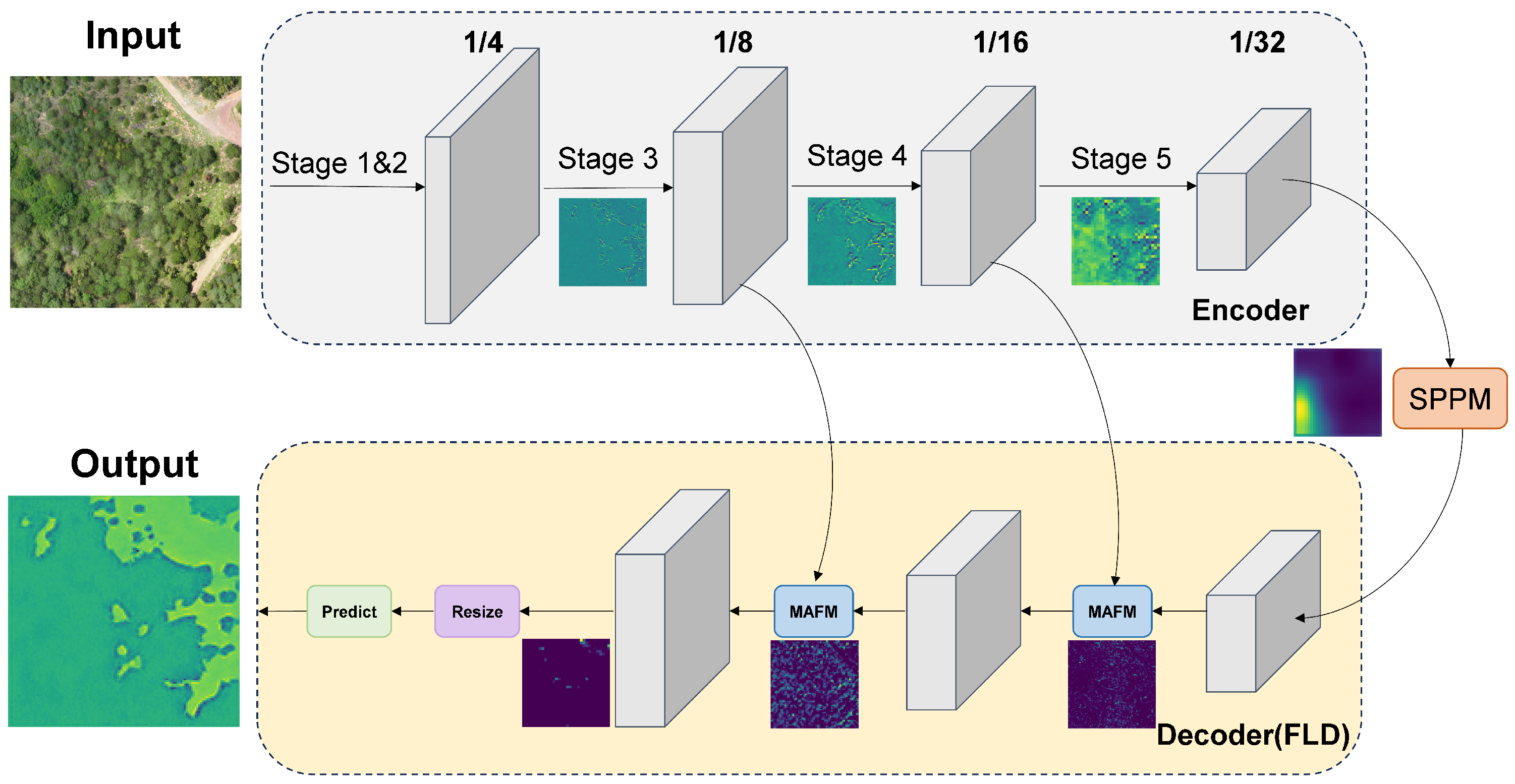
The overall architecture, as illustrated in
Figure 3, consists of three main components: the STDC encoder, a Simple Pyramid Pooling Module (SPPM) for context aggregation, and a Flexible Lightweight Decoder (FLD) for segmentation map reconstruction. The input image is first encoded by the STDC backbone, which produces multi-level feature maps at 1/4, 1/8, and 1/16 of the original resolution through progressive downsampling, capturing local textures and mid-level semantics.
The encoder’s output is then fed into the SPPM. This module captures contextual information at multiple receptive fields via parallel pooling operations at different scales. The pooled features are upsampled and fused with the backbone features, significantly enhancing the network’s perception of large-scale forest structures and complex backgrounds.
Finally, the FLD decoder reconstructs the high-resolution segmentation map. It adopts a progressive upsampling design with skip connections, effectively fusing rich spatial details from shallow encoder features with high-level semantic information from the SPPM output. By employing lightweight convolutional blocks, the FLD recovers spatial resolution efficiently, enabling detailed predictions while maintaining low computational cost.
Multi-Branch Attention Fusion Module (MAFM)
A key innovation in our improved network is the introduction of a lightweight Multi-Branch Attention Fusion Module (MAFM), designed to better integrate multi-scale semantic information and focus on discriminative features critical for distinguishing forest boundaries.
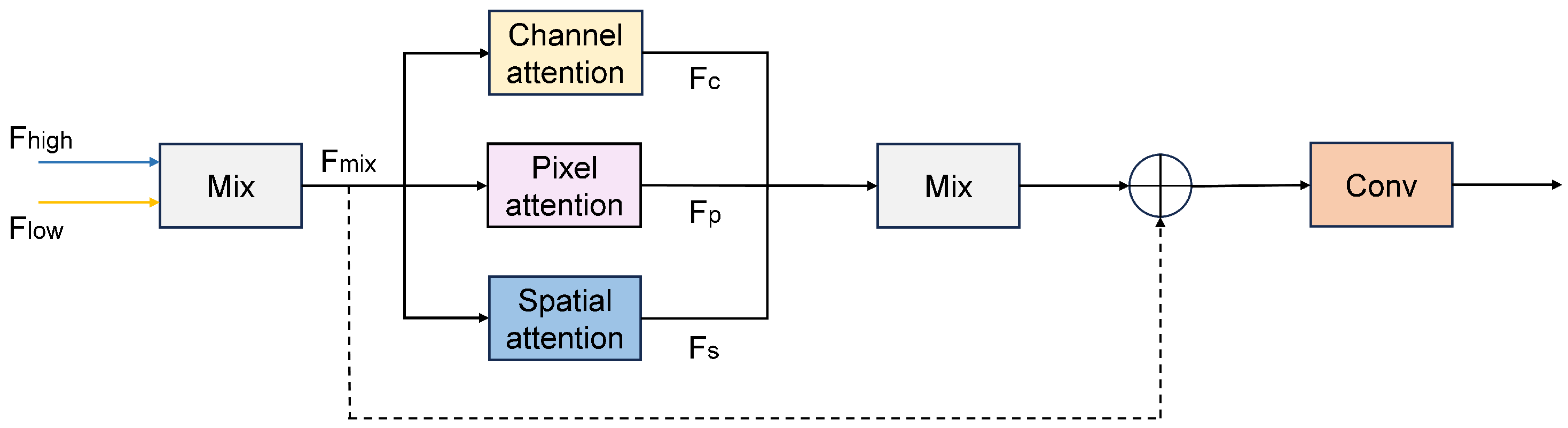
The structure of the MAFM is shown in
Figure 4. The module operates by first upsampling and fusing shallow and deep features using learnable parameters. The fused feature map is then processed in parallel by three dedicated attention branches:
Channel Attention Branch: Recalibrates the importance of feature channels.
Pixel Attention Branch: Emphasizes spatially significant pixel locations.
Spatial Attention Branch: Highlights broader contextual regions.
Figure 4.
Structure of the Multi-Branch Attention Fusion Module (MAFM). The module integrates channel, pixel, and spatial attention mechanisms in parallel. In the V02 version, a residual connection (dashed line) is introduced on top of the basic three-branch structure to enhance the stability and robustness of feature fusion.
Figure 4.
Structure of the Multi-Branch Attention Fusion Module (MAFM). The module integrates channel, pixel, and spatial attention mechanisms in parallel. In the V02 version, a residual connection (dashed line) is introduced on top of the basic three-branch structure to enhance the stability and robustness of feature fusion.
The outputs of these three branches are aggregated via convolution to produce a refined and more discriminative feature representation. This design allows the network to jointly attend to local details and larger-scale structures, improving its ability to handle complex boundary conditions in UAV forest imagery.
We evaluate two specific variants of this module:
In summary, our improved PP-LiteSeg strengthens feature representation through a streamlined base architecture combined with the targeted MAFM enhancement, while preserving its lightweight nature. The structural distinction between V01 and V02 leads to their complementary strengths: V01 excels in structurally regular plantation forests with clear boundaries, whereas V02, with its residual connections, demonstrates superior stability and adaptability in naturally heterogeneous forests characterized by complex textures and variable illumination.
3.4. Experimental Settings
All experiments were conducted under a consistent hardware and software environment to ensure fair and reproducible comparisons. Model training and inference were performed on a server equipped with an NVIDIA GeForce RTX 4090 GPU (24 GB VRAM), using the PaddlePaddle deep learning framework and its PaddleSeg toolkit within a Python 3.8 environment [
33].
To isolate the impact of network architecture, all models were trained with an identical protocol. We used the Adam optimizer with an initial learning rate of (linearly scaled with batch size) and a minimum learning rate of . Training proceeded for 1000 epochs with a batch size of 8, and all inputs were resized to 1024 × 1024 pixels. A fixed random seed was used throughout, and mixed-precision (FP16) training was disabled to ensure deterministic and reproducible results.
To improve model robustness and simulate real-world variations in UAV imagery, we applied standard data augmentations including random scaling, cropping, horizontal flipping, and random adjustments to brightness, contrast, and saturation. All input images were normalized using the ImageNet mean and standard deviation [
34].
These controlled settings established a unified and reproducible experimental foundation for the subsequent performance evaluation.
3.5. Evaluation Metrics
To comprehensively evaluate model performance on the binary forest segmentation task, we employed four standard metrics: Precision, Recall, F1-score, and mean Intersection over Union (mIoU).
The evaluation metrics were computed based on the pixel-level confusion matrix, where true positives (TP) denote forest pixels correctly predicted as forest, false positives (FP) denote non-forest pixels misclassified as forest, false negatives (FN) denote forest pixels misclassified as non-forest, and true negatives (TN) denote non-forest pixels correctly classified.
Precision, Recall, and F1-score for the forest class are defined as:
The mIoU serves as our primary metric for overall segmentation accuracy. It is calculated as the average of the Intersection over Union (IoU) values for the forest and non-forest classes:
Precision, Recall, and the F1-score (their harmonic mean) offer complementary insights into classification reliability. These metrics are particularly informative for assessing model performance in challenging scenarios, such as ambiguous boundary regions and fragmented forest patches, where segmentation models often face increased uncertainty.
4. Experiments
4.1. Experiment Design
We designed a progressive four-stage experimental protocol to systematically evaluate segmentation accuracy, robustness, and cross-regional generalization. Experiments were conducted on three datasets: the Huayuan Forest Farm dataset (plantation-dominated, structurally regular), the Longhai Township dataset (natural forest-dominated, heterogeneous), and a combined dataset integrating both regions.
Stage 1: In-domain evaluation on the Huayuan dataset. This stage establishes baseline performance in a controlled plantation environment. We compared representative segmentation models, including U-Net, PSPNet, DeepLabv3+, BiSeNetV2, SegFormer-B0, and the proposed PP-LiteSeg variants.
Stage 2: In-domain evaluation on the Longhai dataset. This stage tests robustness under high spatial heterogeneity with complex textures, mixed backgrounds, and strong illumination variation, using the same set of baseline models and training protocol.
Stage 3: Pooled mixed-region evaluation on the combined dataset. By training and testing on a dataset that contains both plantation and natural forest samples (with a patch-level split), we assess overall robustness under mixed scene composition and regional diversity, simulating a practical multi-region deployment scenario.
Stage 4: Cross-regional transfer evaluation. To explicitly assess cross-regional generalization under domain shift, we performed bidirectional transfer experiments by training models on one region and directly testing them on the other without fine-tuning (Huayuan → Longhai and Longhai → Huayuan).
4.2. Experiment Results and Analysis
4.2.1. Huayuan Forest Farm Experimental Results
Comparative Experiment
We first evaluated the performance of different semantic segmentation models on the Huayuan Forest Farm dataset, an environment characterized by flat terrain, uniform canopy distribution, and clear boundaries with low spatial heterogeneity. This regular plantation scene provides an ideal testbed for assessing feature extraction and boundary delineation capabilities. Under a unified training protocol, we conducted a rigorous comparison among U-Net, PSPNet, DeepLabv3+, and our improved PP-LiteSeg variants.
Quantitative results are presented in
Table 2. Among the conventional CNN baselines (U-Net, PSPNet, and DeepLabv3+), the mIoU ranges from 71.82% to 74.42%. The two additional lightweight baselines, SegFormer-B0 and BiSeNetV2, substantially improve performance, achieving mIoU values of 84.08% and 83.06%, respectively. Notably, the PP-LiteSeg series further enhances segmentation accuracy, with all variants exceeding 81% mIoU. In particular, the STDC1-V01 model achieves the best overall performance, with a Precision of 96.20%, Recall of 96.01%, F1-score of 96.10%, and an mIoU of 92.64%, representing an 18.84 percentage-point improvement over PSPNet. These results demonstrate that in structured plantation environments, the proposed multi-branch attention mechanism (V01) effectively enhances discriminative feature representation and boundary precision.
A key challenge in the Huayuan dataset is severe class imbalance, with forest pixels dominating and non-forest areas being scarce and fragmented. While traditional models maintain high recall for the majority forest class, they struggle to accurately segment the minority non-forest class, leading to frequent confusion between forest and non-forest pixels, as reflected by their low IoU-Non-Forest values (48.77–54.51%). In contrast, STDC1-V01 dramatically improves the IoU for non-forest areas to 87.28%, indicating its superior ability to focus on subtle spatial and textural differences to identify scarce non-forest pixels.
Comparing the two improved variants, V01 slightly outperforms V02 in this regular plantation setting. The residual connection in V02 is designed to stabilize feature fusion in complex, noisy environments. However, in Huayuan’s uniform texture and stable illumination conditions, the more direct attention enhancement of V01 proves more effective for leveraging dominant texture features. Regarding the backbone, the lighter STDC1 is more suitable than STDC2 for this scenario, with limited sample size and regular structure, offering faster convergence and more stable performance.
In summary, STDC1-V01 delivers the best performance on the Huayuan dataset. Its success underscores the strong alignment between its lightweight architecture with multi-branch attention and the structural regularity of plantation forests, highlighting its high accuracy and adaptability for regular forest segmentation tasks.
Single-Band Experiments
To investigate the specific contribution of spectral information, we conducted single-band experiments on the Huayuan dataset, using the Red, Green, Red Edge, and Near-Infrared (NIR) bands separately as model input. The results are summarized in
Table 3.
The PP-LiteSeg models demonstrated high consistency across all single-band inputs. Forest class IoU remained stable between 93–94%, confirming robust forest recognition regardless of spectral band. The primary performance variation stemmed from the non-forest class, where IoU fluctuated between 61–66%, directly driving changes in overall mIoU.
Spectral Band Analysis: The NIR and Green bands yielded the highest overall mIoU (79–80% for most models). Their strong reflectance contrast between vegetation and non-vegetation areas effectively aids in delineating forest boundaries and canopy structures. The Red Edge band provided stable, complementary performance. In contrast, the Red band achieved the lowest mIoU (78–79%), as it offers limited spectral discriminability for vegetation, especially in shadowed areas or under varying illumination, leading to increased confusion between forest and non-forest pixels.
Model Variant Analysis: No single model variant consistently dominated across all bands. The best-performing model varied by band (e.g., STDC1-V02 for Red, STDC2-V01 for Green, STDC1-V01 for Red Edge, STDC2-V02 for NIR), indicating that the optimal architecture–spectrum pairing is band-dependent. This suggests that different spectral bands may engage complementary aspects of the model’s attention mechanisms.
Key Insight and Limitation: The non-forest class remains the primary bottleneck for single-band segmentation accuracy. The subsequent multi-band fusion experiments (reported in the next section) did not yield substantial gains over the best single bands, indicating that simple band stacking offers limited benefit for this specific task. Future work could explore adaptive spectral feature selection or fusion strategies, potentially combined with boundary enhancement or class-balancing techniques, to further improve performance in complex backgrounds.
Multi-Band Fusion Experiments
Building on the single-band analysis, we further assessed the complementarity of multispectral information by conducting fusion experiments. We selected the three top-performing bands—Near-Infrared (NIR), Green, and Red Edge—and fused them via direct band stacking into a three-channel input, aiming to enhance forest boundary and structural recognition by integrating spectral contrasts.
Table 4 shows that simple multispectral band stacking (NIR + Green + RedEdge) yields only marginal differences compared with the best-performing single-band results, with mIoU values remaining in the range of approximately 79–80%. This indicates that, within the multispectral modality itself, the selected bands exhibit substantial redundancy over the spectrally and structurally homogeneous plantation canopies in the Huayuan Forest Farm. Under this setting, naive early fusion by direct band stacking does not effectively introduce complementary discriminative information for the binary forest/non-forest segmentation task.
It is important to emphasize that the multispectral experiments reported here are not directly comparable to the high-resolution RGB results presented in
Table 2. The RGB imagery is acquired at a substantially higher native spatial resolution than the multispectral data, resulting in much richer texture cues, sharper boundary representation, and higher effective information density. These spatial details play a dominant role in delineating forest–non-forest boundaries in plantation environments. Consequently, the much lower mIoU observed in the multispectral single-band and fusion settings should not be interpreted as evidence that multispectral information is intrinsically inferior to RGB. Instead, it primarily reflects the confounding effect of unequal spatial resolution, which makes a direct performance comparison between multispectral and RGB inputs methodologically invalid under the current setting.
To decouple the effect of spatial resolution from the effect of spectral modality and enable a fairer comparison, we therefore introduce a resolution-controlled RGB baseline in the subsequent section. By downsampling RGB imagery to match the effective spatial resolution of the multispectral data while keeping the network architecture and training protocol unchanged, we aim to isolate whether the observed performance gap is driven mainly by spatial detail loss or by the spectral characteristics of the input.
Resolution-Controlled RGB Baseline (RGB Downsampling)
A major practical concern in UAV multispectral experiments is that the RGB imagery (20 MP) and multispectral (MS) imagery (5 MP) are acquired by different sensors with substantially different native spatial resolutions. This resolution gap may bias direct comparisons and could partially explain why RGB input often outperforms MS band stacking. To ensure a fair and reproducible evaluation, we further conducted a resolution-controlled experiment by downsampling RGB imagery to match the effective spatial resolution of the MS input used in the fusion setting. The RGB and multispectral images were co-registered at the orthomosaic level using the same georeferencing framework, ensuring pixel-level alignment before patch extraction.
Specifically, for each 1024 × 1024 RGB patch, we applied a two-step resampling strategy: (1) downsampling the RGB patch to the MS-equivalent scale using area interpolation to avoid aliasing, and (2) upsampling it back to 1024 × 1024 using bilinear interpolation to satisfy the fixed network input size. This procedure preserves comparable spatial information density while maintaining an identical training pipeline and normalization strategy as the RGB experiments. The results are reported in
Table 5.
As shown in
Table 5, after explicitly matching the effective spatial resolution to the multispectral modality, the downsampled RGB baseline achieves mIoU values in the range of approximately 79–80%, which is close to the multispectral fusion results reported in
Table 4. For instance, STDC1-V01 attains an mIoU of 80.23% under resolution-matched RGB input, which is slightly higher than the corresponding multispectral fusion result (79.76%). This observation indicates that, once spatial resolution is controlled, RGB and multispectral inputs exhibit comparable performance levels under the same network architecture and training protocol.
Crucially, this resolution-controlled comparison should be interpreted at the multispectral resolution level and should not be conflated with the high-resolution RGB results in
Table 2, where STDC1-V01 achieves a substantially higher mIoU of 92.64%. The large performance gap between the original high-resolution RGB setting and the resolution-matched RGB or multispectral settings confirms that segmentation accuracy in plantation forests is predominantly driven by spatial detail and texture richness rather than by the mere availability of additional spectral channels. The remaining small advantage of resolution-matched RGB over simple multispectral stacking further suggests that, beyond spatial resolution, factors such as input distribution alignment with ImageNet-pretrained backbones and the lack of modality-aware fusion mechanisms also contribute to the observed differences. Overall, this experiment demonstrates that the performance disparity between RGB and multispectral inputs observed in previous sections is primarily attributable to unequal spatial resolution, and that fair modality comparison in UAV forest segmentation requires explicit resolution alignment.
We attribute this phenomenon to three factors. First, forest–non-forest segmentation in plantation scenes is strongly dominated by structural and textural cues (e.g., canopy geometry, row-like plantation patterns, and boundary continuity), which remain largely preserved even after RGB downsampling. Second, the selected multispectral bands (NIR, Green, and Red Edge) provide highly redundant signals in spectrally homogeneous plantation forests, and simple band stacking does not effectively exploit complementary spectral information. Third, the employed backbones and training strategies are primarily optimized for RGB imagery; even after resolution degradation, RGB inputs preserve more stable low-level edge and texture priors, whereas simple multispectral stacking introduces distribution shifts that are not explicitly modeled by the current fusion strategy.
Overall, this resolution-controlled experiment strengthens the conclusion that, under the current straightforward fusion scheme, segmentation performance is primarily driven by spatial structure rather than by additional spectral channels. More advanced spectral fusion mechanisms (e.g., attention-based cross-band fusion or modality-specific normalization and adapters) may be required to fully exploit multispectral UAV data. Consequently, RGB imagery is used as the standard input modality in all subsequent experiments to ensure experimental consistency and fair comparison across different datasets.
4.2.2. Longhai Township Experimental Results
To evaluate model generalization in complex natural forest environments, we conducted experiments on the Longhai Township dataset. Compared to Huayuan, Longhai exhibits pronounced terrain variation, diverse forest types (natural forest, shrubs, bare land, farmland), and significant illumination and shadow changes, resulting in high spatial heterogeneity. This scenario tests model adaptability and robustness in unstructured forest landscapes.
Using the same training protocol and RGB input as in the Huayuan experiments, we evaluated all models. Quantitative results are presented in
Table 6.
Overall Performance: All models achieved satisfactory results (mIoU > 85%) in this complex environment. In addition to conventional CNN baselines, SegFormer-B0 and BiSeNetV2 also achieved strong performance, with mIoU values of 90.36% and 90.59%, respectively, demonstrating the effectiveness of transformer-based global context modeling and lightweight real-time CNN designs in heterogeneous natural forest scenes. Nevertheless, the PP-LiteSeg series further improves segmentation accuracy. The best performer, STDC1-V02, achieved an mIoU of 91.87%, which is 5.72 percentage points higher than DeepLabv3+ and 3.13 points higher than U-Net, clearly demonstrating the advantage of the proposed lightweight attention-enhanced architecture in natural forests.
Analysis of Model Variants: The V02 variant, which incorporates residual connections, outperformed V01 in this heterogeneous setting. The residual-enhanced design stabilizes feature propagation under strong illumination variations, shadows, and mixed textures, resulting in more reliable segmentation in regions with irregular boundaries and weak texture cues (e.g., forest–shrub transition zones).
Backbone Comparison: Contrary to the expectation that a deeper backbone might excel in complex environments, the lighter STDC1 backbone outperformed STDC2 in the Longhai dataset. The shallower STDC1 backbone is easier to optimize and appears more robust to noise and limited training samples typical of highly heterogeneous natural forests, whereas the deeper STDC2 backbone may suffer from less stable training under such conditions.
Key Insight: The combination of the lightweight STDC1 backbone and the residual-enhanced attention mechanism (V02) proves highly effective for natural forest segmentation. This architecture enables stable feature extraction and strong robustness against environmental noise, which is crucial for maintaining reliable generalization performance in cross-regional forest segmentation applications.
4.2.3. Cross-Regional Generalization Experiments
To further evaluate the cross-regional generalization capability of different models, we conducted bidirectional cross-dataset experiments. Specifically, all models were trained on one region and directly tested on the other region without any fine-tuning. This setting represents a challenging and realistic application scenario, as the Huayuan Forest Farm and Longhai Township datasets differ significantly in forest structure, terrain complexity, texture distribution, and illumination conditions.
Training on Longhai and testing on Huayuan. The results are reported in
Table 7. Most baseline models suffer from severe performance degradation when transferring from heterogeneous natural forests to structured plantation scenes. Traditional CNN-based models, such as U-Net and DeepLabv3+, exhibit substantial drops in IoU-Non-Forest (41.84–43.56%), indicating limited robustness under domain shift. SegFormer-B0 and BiSeNetV2 achieve relatively better generalization performance, with mIoU values of 77.18% and 77.87%, respectively, benefiting from global context modeling and efficient feature fusion. In contrast, PP-LiteSeg-STDC1-V02 achieves the highest mIoU of 85.42%, showing a markedly smaller degradation than the conventional baselines under domain shift.
Training on Huayuan and testing on Longhai. As shown in
Table 8, transferring from plantation forests to complex natural forest environments remains challenging for all models. Nevertheless, transformer-based and lightweight CNN baselines (SegFormer-B0 and BiSeNetV2) maintain relatively strong generalization ability, achieving mIoU values of 88.70% and 88.88%, respectively. The proposed PP-LiteSeg-STDC1-V02 further improves performance, achieving the highest mIoU of 89.41%. This result indicates superior robustness under strong texture variation, irregular forest boundaries, and illumination changes commonly observed in natural forests.
Overall, the bidirectional cross-regional experiments confirm that the proposed residual-enhanced attention mechanism significantly improves feature stability under domain shift. Compared with transformer-based segmentation models and real-time lightweight CNN baselines, PP-LiteSeg achieves a more favorable balance between accuracy, robustness, and cross-regional generalization, making it well suited for practical UAV-based forest segmentation across diverse geographical regions.
4.2.4. Comprehensive Dataset Experimental Results
To evaluate model generalization across diverse regions and forest types, we conducted experiments on the combined dataset integrating Huayuan (plantation) and Longhai (natural forest). This composite benchmark features the full spectrum of challenges: structural regularity, high heterogeneity, terrain variation, and illumination changes, providing a rigorous test for model robustness under complex, cross-regional conditions. We maintained the same experimental protocol (RGB input, hyperparameters) for consistency. The quantitative segmentation results on the comprehensive dataset are summarized in
Table 9.
All models achieve competent performance (mIoU > 83%) on the combined dataset, demonstrating basic cross-regional adaptability across plantation and natural forest scenes. SegFormer-B0 and BiSeNetV2 maintain strong generalization capability, achieving mIoU values of 90.74% and 90.71%, respectively, indicating that both transformer-based global context modeling and lightweight real-time CNN designs are effective under cross-regional domain shifts. Nevertheless, the PP-LiteSeg series further improves segmentation performance. The best overall model, STDC1-V02, attains an mIoU of 91.50%, which is 3.57 percentage points higher than DeepLabv3+ and 2.42 points higher than U-Net.
Key Observations. The attention-refined variants (V01, V02) consistently outperform both the baseline PP-LiteSeg (spa) and traditional models, highlighting the value of the introduced multi-branch attention and residual mechanisms.
Although V01 shows a slight edge in Precision and F1-score, V02 achieves the highest mIoU, driven by its superior performance on the non-forest class (IoU 88.59%) and forest class (IoU 94.41%). This indicates that the residual connections in V02 provide more balanced and robust feature representation across the diverse scenes in the combined dataset, mitigating domain shift and texture complexity better than V01.
As in the Longhai experiments, the lighter STDC1 backbone leads to better generalization than STDC2 on the composite data. Its easier optimization and robustness to noise appear to be more valuable than the increased capacity of STDC2 for this cross-regional task.
The STDC1-V02 model, with its lightweight backbone and residual-enhanced attention mechanism, demonstrates excellent cross-regional generalization. It effectively balances performance across plantation and natural forest types, achieving the highest overall accuracy on the combined dataset. This result confirms its strong transferability and practical potential for real-world UAV forest segmentation applications that span diverse geographical and forest structural conditions.
4.3. Visualization Results and Analysis
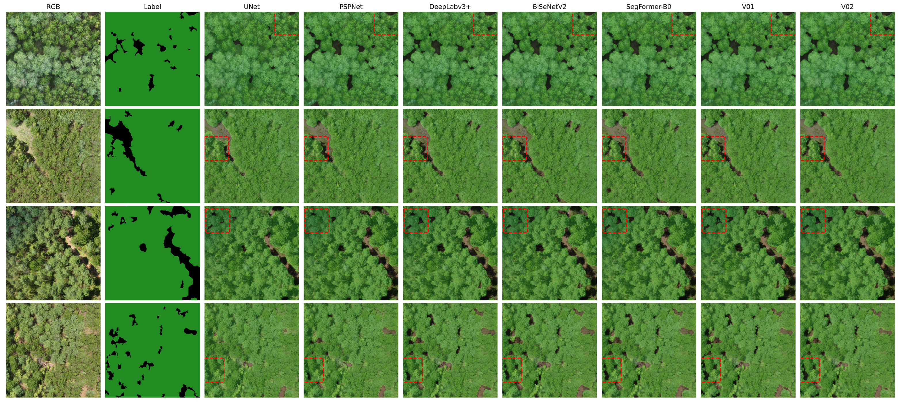
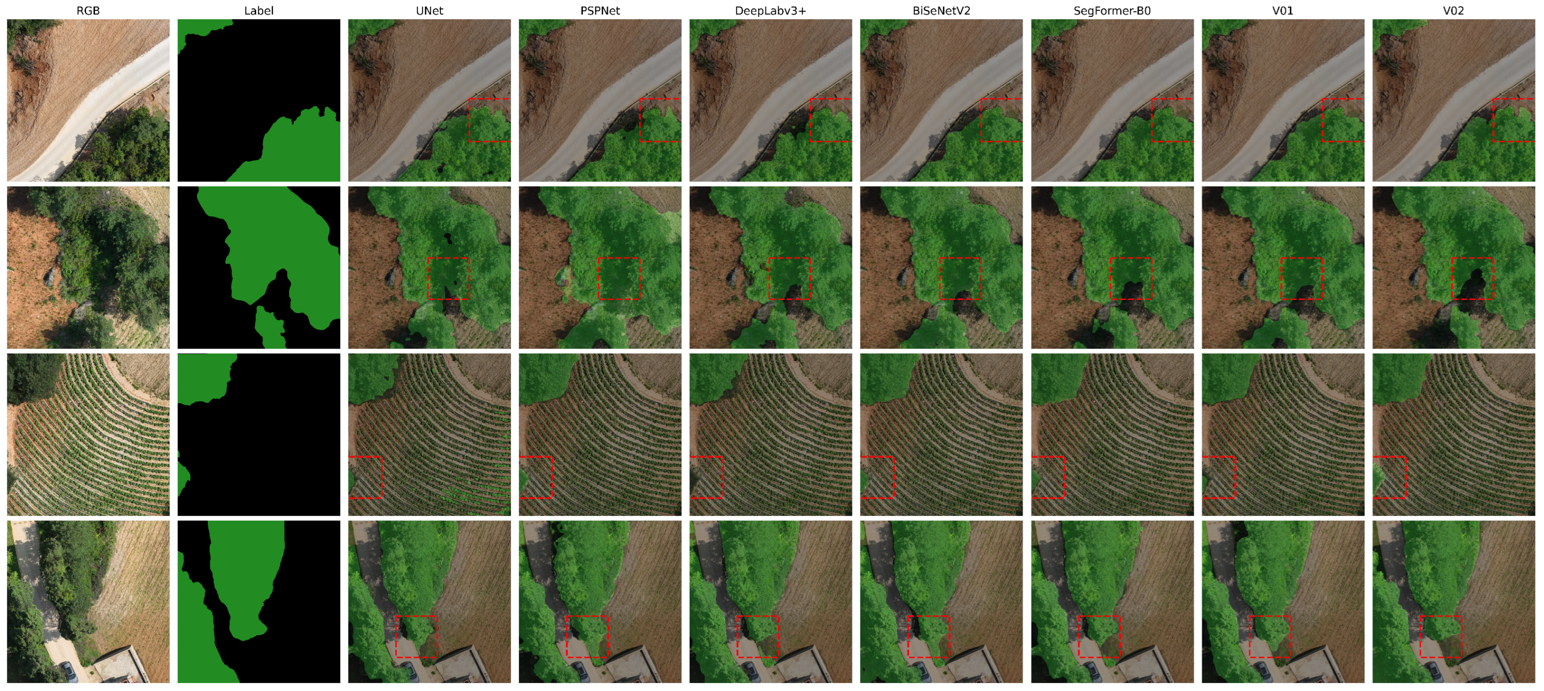
To provide an intuitive and comprehensive comparison of segmentation performance, we present qualitative visualization results across multiple representative models, including U-Net, PSPNet, DeepLabv3+, BiSeNetV2, SegFormer-B0, and the proposed PP-LiteSeg-STDC1 variants (V01 and V02). The visual analysis focuses on forest–non-forest boundaries, fragmented non-forest regions, and challenging areas affected by illumination variation and texture heterogeneity. Red dashed boxes highlight regions where different models exhibit noticeable differences.
4.3.1. Visualization Results on the Huayuan Forest Farm
Figure 5 shows segmentation results on the Huayuan Forest Farm dataset, which is characterized by regular plantation patterns, relatively uniform canopy textures, and clearly defined forest–non-forest boundaries.
Traditional convolutional models (U-Net, PSPNet, and DeepLabv3+) correctly capture the overall forest distribution but exhibit clear limitations at forest–non-forest transitions. As highlighted by the red boxes, these models frequently produce boundary expansion, pixel adhesion, and omission of small non-forest patches, particularly near roads and canopy gaps. DeepLabv3+ shows moderate improvement over U-Net and PSPNet, yet still struggles with fine-scale boundary delineation.
Among the modern baselines, BiSeNetV2 produces smoother predictions and improves continuity in large forest regions, but its boundaries are often over-smoothed, leading to partial loss of small non-forest structures. SegFormer-B0 demonstrates stronger global consistency and better suppression of noise, benefiting from its transformer-based context modeling; however, it still tends to blur narrow non-forest regions and fine boundary details in structured plantation scenes.
The proposed PP-LiteSeg variants show clear advantages. V01 exhibits the most precise boundary delineation, closely matching the ground truth in forest–road interfaces and fragmented non-forest patches. Its multi-branch attention mechanism effectively enhances sensitivity to fine structural cues, resulting in sharp and well-aligned boundaries in this regular environment. V02 produces slightly smoother boundaries but delivers more balanced predictions overall, particularly in weak-texture or lightly shadowed regions. This reflects its residual-enhanced design, which emphasizes feature stability while retaining competitive boundary accuracy.
In summary, within the structured Huayuan plantation, V01 achieves the best boundary precision, while V02 provides a favorable trade-off between boundary accuracy and robustness, outperforming both traditional CNNs and recent lightweight or transformer-based baselines.
4.3.2. Visualization Results on the Longhai Dataset
Figure 6 presents visualization results on the Longhai dataset, which represents a highly heterogeneous natural forest environment with mixed shrubland, bare soil, farmland, complex terrain, and strong illumination and shadow variations.
Traditional models exhibit pronounced instability under these complex conditions. U-Net is particularly sensitive to illumination changes, producing discontinuous and noisy predictions in shadowed regions. PSPNet and DeepLabv3+ often misclassify shrubs and bare soil as forest, leading to boundary over-expansion and fragmented segmentation in mixed-background areas.
The modern baselines demonstrate improved robustness. BiSeNetV2 maintains relatively stable predictions in large forest regions but still suffers from boundary leakage and local misclassification under strong texture variation. SegFormer-B0 shows stronger global coherence and reduced noise, especially in heterogeneous areas; however, its boundaries may deviate from the ground truth in narrow transition zones and under severe illumination contrast.
The proposed PP-LiteSeg variants handle these challenges more effectively. V01 maintains relatively sharp boundaries in many regions but becomes less stable under abrupt texture changes, occlusions, and strong shadows, occasionally producing local fragmentation. In contrast, as observed in the highlighted boundary and shadowed regions in
Figure 6, V02 delivers the most consistent and reliable predictions across the scene. It preserves coherent forest structures on slopes, in mixed shrub–forest zones, and under shadowed conditions, with boundaries closely aligned to the ground truth. The residual-enhanced attention structure effectively suppresses noise and mitigates feature drift caused by complex illumination and texture variation.
Overall, in the highly heterogeneous Longhai environment, STDC1-V02 demonstrates superior robustness and adaptability, outperforming both traditional CNN-based models and recent lightweight or transformer-based baselines. While V01 excels in boundary clarity under simpler conditions, V02 is better suited for natural forests where stability and generalization are critical.
4.4. Attention Visualization Analysis
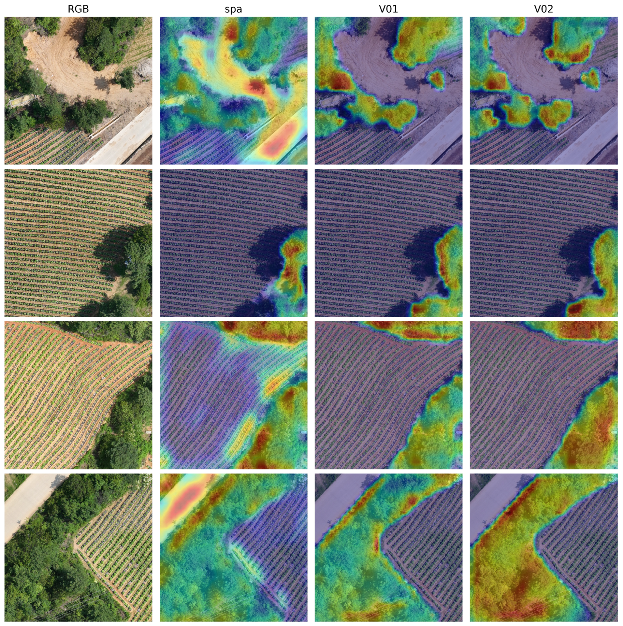
To gain deeper insights into model behavior, we visualized the attention responses of three PP-LiteSeg-STDC1 variants—Spa (baseline), V01 (multi-branch attention), and V02 (residual-enhanced attention)—using Grad-CAM [
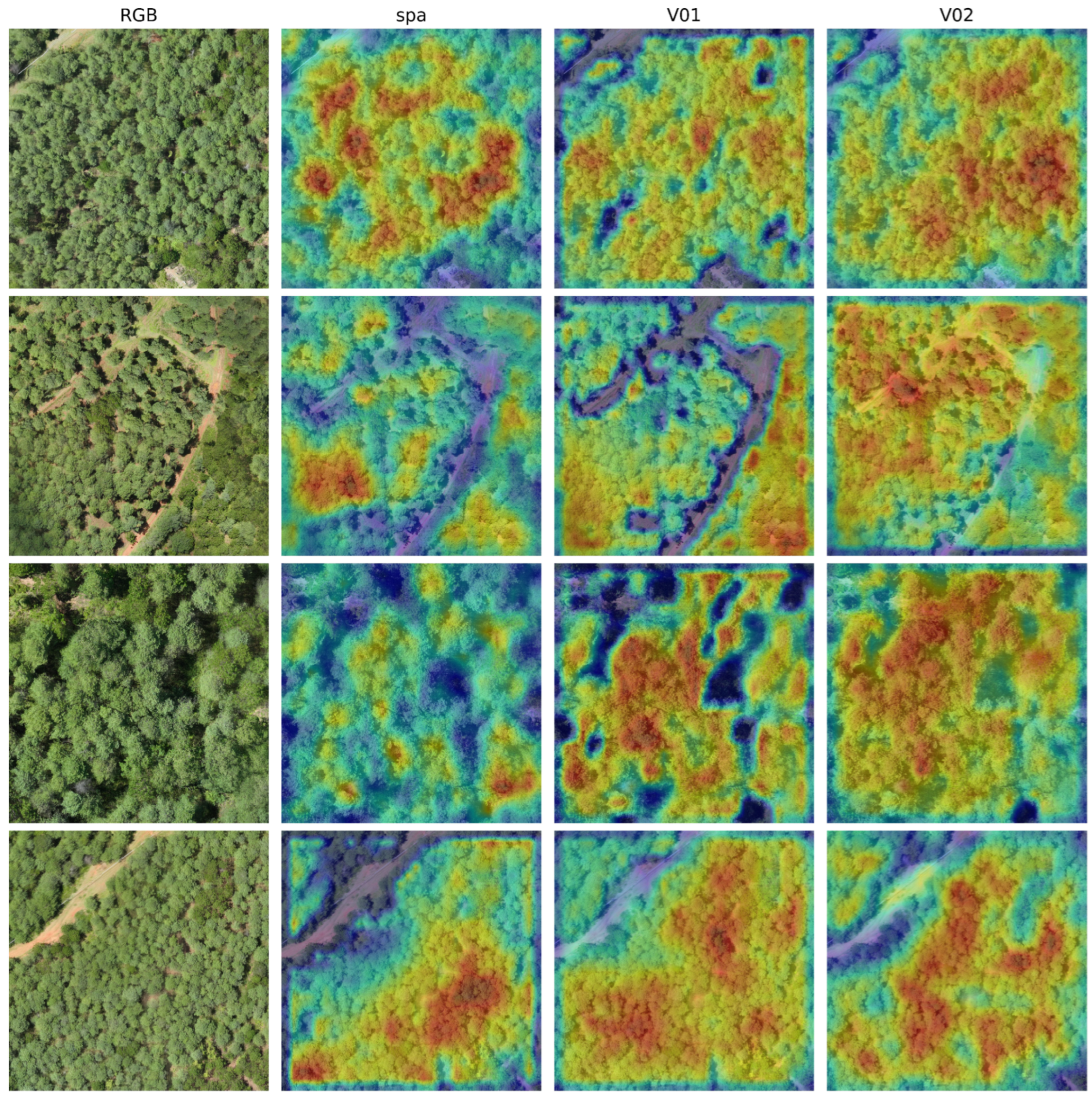
35]. Representative images from Huayuan Forest Farm (structured plantation) and Longhai Township (complex natural forest) were selected to analyze how attention mechanisms adapt to varying spatial structures and texture heterogeneity. The Grad-CAM visualization was generated with respect to the forest class output, using the final convolutional feature map of the decoder before upsampling as the target layer. In the heatmaps, red-to-yellow indicates strong feature responses, while blue indicates weak responses. We emphasize that these visualizations are intended to provide qualitative insights into feature focus and response stability, rather than per-pixel attribution or strict mechanistic explanations.
4.4.1. Attention Analysis in the Huayuan Forest Farm
Figure 7 presents Grad-CAM heatmaps for the Huayuan region, characterized by regular canopy patterns and clear boundaries, ideal for evaluating boundary sensitivity.
Spa (Baseline) exhibits the most dispersed attention distribution. While it activates over large forested areas, its responses at critical forest–non-forest transitions, road edges, and canopy gaps are often blurry or missing, explaining its weaker boundary delineation in quantitative results.
V01 (Multi-Branch Attention) demonstrates the most focused and distinct responses. Its high-activation regions precisely cover structural transitions, small non-forest patches, and road intersections, showing a clear boundary enhancement effect. The multi-branch mechanism effectively integrates pixel, spatial, and channel features, enabling superior sensitivity to fine structural details in regular plantation scenes.
V02 (Residual-Enhanced Attention) shows smoother and more continuous responses. Although its edge enhancement is slightly less pronounced than V01’s, its attention is more balanced and stable, even in shadowed or low-texture areas. The residual connections help suppress local noise while maintaining global semantic consistency, enhancing overall robustness.
In summary, within Huayuan’s structured plantation environment, V01 specializes in boundary enhancement and fine-detail capture, while V02 prioritizes global consistency and noise resistance. These distinct attention patterns align perfectly with their respective segmentation performance: V01 achieves higher boundary accuracy, whereas V02 offers greater stability.
4.4.2. Attention Analysis in the Longhai Township
Figure 8 presents Grad-CAM heatmaps for the Longhai Township, an area defined by complex land cover, dramatic texture variations, and strong illumination/shadow contrasts, demanding high feature stability and spatial attention.
Spa (Baseline) exhibits unstable and scattered attention under these complex conditions. It is easily distracted by background textures and shadows, leading to response drift and mis-focusing, especially in boundary zones with mixed shrubs, bare soil, and farmland. This instability contributes to its higher misclassification risk.
V01 (Multi-Branch Attention) forms more concentrated high-response regions in well-defined forest areas, showing an advantage in boundary localization. However, in areas with mixed textures or uneven illumination, its attention can become discontinuous, revealing limited adaptability to high heterogeneity.
V02 (Residual-Enhanced Attention) demonstrates the most complete and stable attention distribution. Its responses are coherent and focused on key structures while effectively suppressing non-target interference. Crucially, in challenging heterogeneous regions—forest edges, shadowed zones, shrub transitions—V02 maintains high consistency and discriminative power. The residual-enhanced structure bolsters its resilience to texture noise and illumination changes, underpinning its superior generalization in natural forests.
In summary, within the complex Longhai environment, V02’s stable and discriminative attention pattern directly explains its strong quantitative robustness. V01, while structurally enhanced, remains more sensitive to complex interference. The Spa baseline is most vulnerable to noise, resulting in the weakest performance. This visualization confirms that the residual connections in V02 are key to its enhanced cross-regional generalization in highly heterogeneous natural forests.
5. Discussion
This study systematically evaluated attention-refined PP-LiteSeg models across distinct forest environments using high-resolution UAV imagery, with a particular focus on cross-regional generalization. In addition to conventional CNN baselines (U-Net, PSPNet, and DeepLabv3+), we included representative lightweight and transformer-based models, namely BiSeNetV2 and SegFormer-B0, to provide a more comprehensive assessment. Overall, the proposed STDC1-based variants (STDC1-V01 and STDC1-V02) achieve superior performance across both the structurally regular Huayuan Forest Farm and the highly heterogeneous Longhai Township, demonstrating that attention refinement within a lightweight framework can deliver strong accuracy and robustness for UAV-based forest segmentation under diverse scenarios.
Although STDC2 provides higher representational capacity, its increased depth and channel width may lead to overfitting to region-specific textures and illumination patterns under heterogeneous forest conditions. This reflects the trade-off between model complexity and data heterogeneity in cross-regional UAV forest segmentation. In contrast, the more compact STDC1 backbone introduces an implicit regularization effect, encouraging the learning of more stable and transferable structural cues, such as canopy continuity and boundary geometry. As a result, STDC1 demonstrates stronger robustness and generalization across diverse forest environments.
Our experiments reveal a clear scene-dependent specialization between the two proposed variants, driven by their architectural differences. In the regular plantation environment of Huayuan, STDC1-V01 achieved the best performance. The uniform textures and clear boundaries in managed forests allow the model to learn stable spatial patterns effectively. V01’s multi-branch attention fusion mechanism excels here by enhancing responsiveness to fine-grained features and sharply focusing on key areas like forest–non-forest transitions and road edges. This leads to superior identification of small non-forest patches, a common weakness in traditional models. The results confirm that a well-designed attention module within a lightweight framework can deliver exceptional boundary delineation accuracy in structured scenes.
Conversely, in the complex natural forest environment of Longhai, STDC1-V02 demonstrated superior robustness and adaptability. The region’s heterogeneous textures, strong shadows, and variable illumination pose significant challenges. V02’s residual-enhanced attention structure is key to its success, effectively mitigating feature drift in complex backgrounds. This allows the model to maintain stable performance in areas with uneven lighting, structural discontinuities, and mixed land cover. Visualization analyses corroborate this, showing that V02 generates smoother, more continuous attention distributions, ensuring reliable predictions under high spatial heterogeneity.
From the perspective of feature fusion theory, the effectiveness of the residual-enhanced design can be explained by residual learning theory. Residual connections preserve the original semantic representation through identity mapping while allowing adaptive refinement via subsequent transformations, thereby mitigating feature drift during deep feature fusion [
36]. In heterogeneous forest scenes characterized by strong texture variation, shadows, and illumination changes, successive non-linear transformations may accumulate noise and distort semantic information. By providing a stable information pathway, residual connections help retain consistent structural cues and prevent excessive deviation during attention-based feature fusion. This mechanism explains the improved robustness of V02 under high spatial heterogeneity.
The spectral experiments provided further insights: individual bands such as NIR and Green outperformed the Red band in separating forest from non-forest areas, benefiting from stronger vegetation reflectance contrast. However, simple early fusion by linear band stacking did not yield notable gains. To disentangle spectral modality from the confounding effect of spatial resolution, we downsampled RGB imagery to an MS-equivalent resolution and re-evaluated the models under an identical pipeline. The resolution-matched RGB baseline achieved performance close to the multispectral stacking setting, indicating that the large advantage observed for the original high-resolution RGB input is primarily driven by spatial detail and texture richness. The remaining small difference between resolution-matched RGB and multispectral stacking is likely related to (i) input distribution alignment with ImageNet-pretrained backbones and (ii) the absence of modality-aware fusion/normalization tailored for multispectral inputs. Overall, these findings suggest that UAV-based forest segmentation in our setting is dominated by structural and textural cues (e.g., canopy geometry and boundary continuity), while exploiting multispectral complementarity likely requires more advanced fusion strategies beyond direct band stacking.
While this study validates the effectiveness of our models, it should be noted that binary forest/non-forest segmentation represents a foundational step rather than a final analytical objective. Accurate forest boundary delineation is essential for downstream applications such as canopy closure estimation, forest inventory, disturbance monitoring, and carbon-related assessments. Certain limitations therefore point to valuable directions for future research. First, our dataset, while carefully constructed, is limited in geographical and forest-type diversity. Although the two study areas were selected to represent contrasting plantation and natural forest structures, they cannot fully capture the full variability of forest ecosystems across different regions. Consequently, although bidirectional cross-regional experiments are conducted in this study, the demonstrated generalization should be interpreted as focused and application-oriented evidence limited to the selected plantation and natural forest settings, rather than as a claim of universal robustness across all forest ecosystems. Future work will focus on extending the evaluation to additional, fully independent regions or publicly available benchmarks, which would enable a more comprehensive assessment of model transferability and facilitate deeper analysis of potential failure modes under unseen forest structures, spectral conditions, and illumination patterns.
6. Conclusions
This study addresses a critical challenge in UAV-based forest semantic segmentation: achieving robust cross-regional generalization under diverse forest structures and environmental conditions. Rather than focusing on increasing architectural complexity, this work investigates how lightweight segmentation frameworks can be systematically enhanced through attention refinement to improve segmentation robustness and scene adaptability in high-resolution UAV imagery.
From a methodological perspective, we present an attention-refined PP-LiteSeg framework that explores the relationship between architectural design and forest scene characteristics. By introducing two complementary variants with distinct attention strategies, this study demonstrates that scene-aware architectural design plays a key role in improving segmentation reliability across structurally regular plantation forests and highly heterogeneous natural forests. The results provide empirical evidence that carefully designed lightweight architectures can achieve strong generalization performance when equipped with appropriate attention mechanisms.
From a data and evaluation standpoint, we construct and publicly release a high-resolution UAV forest dataset covering two representative and structurally contrasting forest types. This dataset enables a controlled yet challenging benchmark for evaluating cross-regional generalization, which remains insufficiently explored in existing UAV forest segmentation studies. The comprehensive experimental protocol, including single-region, cross-region, and mixed-region evaluations, provides a systematic framework for assessing model robustness under real-world domain shifts.
Overall, this work contributes a unified technical framework and a reproducible benchmark for advancing cross-regional UAV forest segmentation. Beyond the specific models presented, the findings highlight the importance of aligning network design with forest scene characteristics, offering valuable methodological insights for future research on robust semantic segmentation in complex natural environments.
Author Contributions
Conceptualization, Z.Q.; methodology, X.M., S.Z. and K.L.; software, X.M., S.Z. and K.L.; validation, K.L. and X.W.; formal analysis, K.L., X.W. and H.L.; investigation, X.W.; resources, K.L. and H.L.; data curation, X.W. and H.L.; writing—original draft preparation, X.M. and S.Z.; writing—review and editing, Z.Q.; visualization, Z.Q.; supervision, Z.Q.; project administration, Z.Q.; funding acquisition, Z.Q. All authors have read and agreed to the published version of the manuscript.
Funding
This work is supported by the Yunnan Fundamental Research Projects (Grant No. 202301BD070001-008, 202401AS070009), the Key Research and Development Projects of Yunnan Province (Grant No. 202402AD080002-5, 202502AD080004-4).
Data Availability Statement
The datasets generated and analyzed during the current study are publicly available.
Conflicts of Interest
The authors declare no conflicts of interest.
Abbreviations
The following abbreviations are used in this manuscript:
| EISeg | Interactive Deep Learning Tool for Segmentation |
| FLD | Flexible Lightweight Decoder |
| Grad-CAM | Gradient-weighted Class Activation Mapping |
| MAFM | Multi-Branch Attention Fusion Module |
| mIoU | Mean Intersection over Union |
| RGB | Red–Green–Blue |
| SPPM | Simple Pyramid Pooling Module |
| STDC | Short-Term Dense Concatenate |
| UAV | Unmanned Aerial Vehicle |
| V01 | PP-LiteSeg variant with Multi-Branch Attention Fusion |
| V02 | PP-LiteSeg variant with Residual-enhanced Attention Fusion |
References
- Birdsey, R.; Pan, Y. Trends in management of the world’s forests and impacts on carbon stocks. For. Ecol. Manag. 2015, 355, 83–90. [Google Scholar] [CrossRef] [Scilit]
- Kangas, A.S. Value of forest information. Eur. J. For. Res. 2010, 129, 863–874. [Google Scholar] [CrossRef] [Scilit]
- Zhang, J.; Zhang, R.; Meng, Q.; Chen, Y.; Deng, J.; Chen, B. UAV as a Bridge: Mapping Key Rice Growth Stage with Sentinel-2 Imagery and Novel Vegetation Indices. Remote Sens. 2025, 17, 2180. [Google Scholar] [CrossRef] [Scilit]
- Guimarães, N.; Pádua, L.; Marques, P.; Silva, N.; Peres, E.; Sousa, J.J. Forestry remote sensing from unmanned aerial vehicles: A review focusing on the data, processing and potentialities. Remote Sens. 2020, 12, 1046. [Google Scholar] [CrossRef] [Scilit]
- Yao, H.; Qin, R.; Chen, X. Unmanned aerial vehicle for remote sensing applications—A review. Remote Sens. 2019, 11, 1443. [Google Scholar] [CrossRef] [Scilit]
- LeCun, Y.; Bengio, Y.; Hinton, G. Deep learning. Nature 2015, 521, 436–444. [Google Scholar] [CrossRef] [Scilit]
- Ronneberger, O.; Fischer, P.; Brox, T. U-net: Convolutional networks for biomedical image segmentation. In Proceedings of the International Conference on Medical Image Computing and Computer-Assisted Intervention; Springer International Publishing: Cham, Switzerland, 2015; pp. 234–241. [Google Scholar]
- Chen, L.-C.; Papandreou, G.; Schroff, F.; Adam, H. Rethinking atrous convolution for semantic image segmentation. arXiv 2017, arXiv:1706.05587. [Google Scholar] [CrossRef] [Scilit]
- Zhao, H.; Shi, J.; Qi, X.; Wang, X.; Jia, J. Pyramid scene parsing network. In Proceedings of the IEEE Conference on Computer Vision and Pattern Recognition; IEEE: Piscataway, NJ, USA, 2017; pp. 2881–2890. [Google Scholar]
- Kempeneers, P.; Sedano, F.; Seebach, L.; Strobl, P.; San-Miguel-Ayanz, J. Data fusion of different spatial resolution remote sensing images applied to forest-type mapping. IEEE Trans. Geosci. Remote Sens. 2011, 49, 4977–4986. [Google Scholar] [CrossRef] [Scilit]
- Rana, S.; Hensel, O.; Nasirahmadi, A. From Vineyard to Vision: Multi-Domain Analysis and Mitigation of Grape Cluster Detection Failures in Complex Viticultural Environments. Results Eng. 2025, 29, 108833. [Google Scholar] [CrossRef] [Scilit]
- Blaga, B.-C.-Z.; Nedevschi, S. Forest Inspection Dataset for Aerial Semantic Segmentation and Depth Estimation. arXiv 2024, arXiv:2403.06621. [Google Scholar] [CrossRef] [Scilit]
- Peng, J.; Liu, Y.; Tang, S.; Hao, Y.; Chu, L.; Chen, G.; Wu, Z.; Chen, Z.; Yu, Z.; Du, Y. Pp-liteseg: A superior real-time semantic segmentation model. arXiv 2022, arXiv:2204.02681. [Google Scholar]
- Shu, D.; Zhang, Z.; Wan, F.; Ru, W.; Yang, B.; Zhang, Y.; Lu, J.; Chen, X. SatViT-Seg: A Transformer-Only Lightweight Semantic Segmentation Model for Real-Time Land Cover Mapping of High-Resolution Remote Sensing Imagery on Satellites. Remote Sens. 2025, 18, 1. [Google Scholar] [CrossRef] [Scilit]
- Lv, J.; Shen, Q.; Lv, M.; Li, Y.; Shi, L.; Zhang, P. Deep learning-based semantic segmentation of remote sensing images: A review. Front. Ecol. Evol. 2023, 11, 1201125. [Google Scholar] [CrossRef] [Scilit]
- Long, J.; Shelhamer, E.; Darrell, T. Fully convolutional networks for semantic segmentation. In Proceedings of the IEEE Conference on Computer Vision and Pattern Recognition; IEEE: Piscataway, NJ, USA, 2015; pp. 3431–3440. [Google Scholar]
- Tang, Y.; Wu, X. Saliency detection via combining region-level and pixel-level predictions with CNNs. In European Conference on Computer Vision; Springer International Publishing: Cham, Switzerland, 2016; pp. 809–825. [Google Scholar]
- Chen, L.-C.; Zhu, Y.; Papandreou, G.; Schroff, F.; Adam, H. Encoder-decoder with atrous separable convolution for semantic image segmentation. In Proceedings of the European Conference on Computer Vision (ECCV), Munich, Germany, 8–14 September 2018; pp. 801–818. [Google Scholar]
- Gao, G.; Xu, G.; Yu, Y.; Xie, J.; Yang, J.; Yue, D. MSCFNet: A lightweight network with multi-scale context fusion for real-time semantic segmentation. IEEE Trans. Intell. Transp. Syst. 2021, 23, 25489–25499. [Google Scholar] [CrossRef] [Scilit]
- Fan, Z.; Zhan, T.; Gao, Z.; Li, R.; Liu, Y.; Zhang, L.; Jin, Z.; Xu, S. Land cover classification of resources survey remote sensing images based on segmentation model. IEEE Access 2022, 10, 56267–56281. [Google Scholar] [CrossRef] [Scilit]
- Yu, C.; Gao, C.; Wang, J.; Yu, G.; Shen, C.; Sang, N. BiSeNet V2: Bilateral network with guided aggregation for real-time semantic segmentation. Int. J. Comput. Vis. 2021, 129, 3051–3068. [Google Scholar] [CrossRef] [Scilit]
- Xie, E.; Wang, W.; Yu, Z.; Anandkumar, A.; Alvarez, J.M.; Luo, P. SegFormer: Simple and efficient design for semantic segmentation with transformers. Adv. Neural Inf. Process. Syst. 2021, 34, 12077–12090. [Google Scholar]
- Keenan, R.J.; Reams, G.A.; Achard, F.; de Freitas, J.V.; Grainger, A.; Lindquist, E. Dynamics of global forest area: Results from the FAO Global Forest Resources Assessment 2015. For. Ecol. Manag. 2015, 352, 9–20. [Google Scholar] [CrossRef] [Scilit]
- Badea, O.; Silaghi, D.M.; Neagu, S.; Taut, I.; Leca, S. Forest monitoring-assessment, analysis and warning system for forest ecosystem status. Not. Bot. Horti Agrobot. Cluj-Napoca 2013, 41, 613–625. [Google Scholar] [CrossRef] [Scilit]
- Dainelli, R.; Toscano, P.; Di Gennaro, S.F.; Matese, A. Recent advances in Unmanned Aerial Vehicles forest remote sensing—A systematic review. Part II: Research applications. Forests 2021, 12, 397. [Google Scholar] [CrossRef] [Scilit]
- Ecke, S.; Dempewolf, J.; Frey, J.; Schwaller, A.; Endres, E.; Klemmt, H.-J.; Tiede, D.; Seifert, T. UAV-based forest health monitoring: A systematic review. Remote Sens. 2022, 14, 3205. [Google Scholar] [CrossRef] [Scilit]
- Wang, R.; Lei, T.; Cui, R.; Zhang, B.; Meng, H.; Nandi, A.K. Medical image segmentation using deep learning: A survey. IET Image Process. 2022, 16, 1243–1267. [Google Scholar] [CrossRef] [Scilit]
- Yu, B.; Yang, L.; Chen, F. Semantic segmentation for high spatial resolution remote sensing images based on convolution neural network and pyramid pooling module. IEEE J. Sel. Top. Appl. Earth Obs. Remote Sens. 2018, 11, 3252–3261. [Google Scholar] [CrossRef] [Scilit]
- Li, K.; Qiang, Z.; Lin, H.; Wang, X. A Multi-Branch Attention Fusion Method for Semantic Segmentation of Remote Sensing Images. Remote Sens. 2025, 17, 1898. [Google Scholar] [CrossRef] [Scilit]
- Yu, C.; Liu, Y.; Xia, X.; Lan, D.; Liu, X.; Wu, S. Precise and fast segmentation of offshore farms in high-resolution SAR images based on model fusion and half-precision parallel inference. IEEE J. Sel. Top. Appl. Earth Obs. Remote Sens. 2022, 15, 4861–4872. [Google Scholar] [CrossRef] [Scilit]
- Hao, Y.; Liu, Y.; Chen, Y.; Han, L.; Peng, J.; Tang, S.; Chen, G.; Wu, Z.; Chen, Z.; Lai, B. EISeg: An efficient interactive segmentation tool based on PaddlePaddle. arXiv 2022, arXiv:2205.08788. [Google Scholar] [CrossRef] [Scilit]
- Russell, B.C.; Torralba, A.; Murphy, K.P.; Freeman, W.T. LabelMe: A database and web-based tool for image annotation. Int. J. Comput. Vis. 2008, 77, 157–173. [Google Scholar] [CrossRef] [Scilit]
- Ma, X.; Liu, Y.; Zhang, H. PaddleSeg: A high-efficient and easy-to-use segmentation library based on PaddlePaddle. arXiv 2021, arXiv:2101.11282. [Google Scholar]
- Deng, J.; Dong, W.; Socher, R.; Li, L.-J.; Li, K.; Fei-Fei, L. ImageNet: A large-scale hierarchical image database. In Proceedings of the IEEE Conference on Computer Vision and Pattern Recognition; IEEE: Piscataway, NJ, USA, 2009; pp. 248–255. [Google Scholar]
- Selvaraju, R.R.; Cogswell, M.; Das, A.; Vedantam, R.; Parikh, D.; Batra, D. Grad-CAM: Visual explanations from deep networks via gradient-based localization. In Proceedings of the IEEE International Conference on Computer Vision; IEEE: Piscataway, NJ, USA, 2017; pp. 618–626. [Google Scholar]
- He, K.; Zhang, X.; Ren, S.; Sun, J. Deep residual learning for image recognition. In Proceedings of the IEEE Conference on Computer Vision and Pattern Recognition; IEEE: Piscataway, NJ, USA, 2016; pp. 770–778. [Google Scholar]
Figure 1.
Study area overview. Huayuan Forest Farm (Yiliang County) and Longhai Township (Luliang County) differ significantly in vegetation types, forest stand structures, and background object complexity, representing typical characteristics of UAV forest imagery under varying spatial heterogeneity conditions.
Figure 1.
Study area overview. Huayuan Forest Farm (Yiliang County) and Longhai Township (Luliang County) differ significantly in vegetation types, forest stand structures, and background object complexity, representing typical characteristics of UAV forest imagery under varying spatial heterogeneity conditions.
Figure 2.
Comparison of annotation tools: (a) EISeg with interactive segmentation and (b) LabelMe with manual polygon annotation. The red dots represent manually annotated points, which are automatically connected to form the final annotation boundaries.
Figure 2.
Comparison of annotation tools: (a) EISeg with interactive segmentation and (b) LabelMe with manual polygon annotation. The red dots represent manually annotated points, which are automatically connected to form the final annotation boundaries.
Figure 3.
Schematic of the improved PP-LiteSeg network architecture. The network consists of an encoder, a Simple Pyramid Pooling Module (SPPM), and a decoder (FLD). Downsampling ratios at each feature stage are annotated to illustrate the transmission and fusion of shallow and deep features across multiple scales.
Figure 3.
Schematic of the improved PP-LiteSeg network architecture. The network consists of an encoder, a Simple Pyramid Pooling Module (SPPM), and a decoder (FLD). Downsampling ratios at each feature stage are annotated to illustrate the transmission and fusion of shallow and deep features across multiple scales.
Figure 5.
Visualization comparison of segmentation results on the Huayuan Forest Farm dataset. From left to right: RGB image, ground truth, predictions by U-Net, PSPNet, DeepLabv3+, BiSeNetV2, SegFormer-B0, PP-LiteSeg-STDC1-V01, and PP-LiteSeg-STDC1-V02. The red dashed boxes highlight representative regions where noticeable differences among models are observed, facilitating visual comparison in complex boundary areas.
Figure 5.
Visualization comparison of segmentation results on the Huayuan Forest Farm dataset. From left to right: RGB image, ground truth, predictions by U-Net, PSPNet, DeepLabv3+, BiSeNetV2, SegFormer-B0, PP-LiteSeg-STDC1-V01, and PP-LiteSeg-STDC1-V02. The red dashed boxes highlight representative regions where noticeable differences among models are observed, facilitating visual comparison in complex boundary areas.
Figure 6.
Visualization comparison of segmentation results on the Longhai dataset. From left to right: RGB image, ground truth, predictions by U-Net, PSPNet, DeepLabv3+, BiSeNetV2, SegFormer-B0, PP-LiteSeg-STDC1-V01, and PP-LiteSeg-STDC1-V02. The red dashed boxes highlight representative regions where noticeable differences among models are observed, facilitating visual comparison in complex boundary areas.
Figure 6.
Visualization comparison of segmentation results on the Longhai dataset. From left to right: RGB image, ground truth, predictions by U-Net, PSPNet, DeepLabv3+, BiSeNetV2, SegFormer-B0, PP-LiteSeg-STDC1-V01, and PP-LiteSeg-STDC1-V02. The red dashed boxes highlight representative regions where noticeable differences among models are observed, facilitating visual comparison in complex boundary areas.
Figure 7.
Grad-CAM visualization for the Huayuan Forest Farm. From left to right: RGB image, Spa, V01, and V02 response heatmaps. V01 shows focused boundary attention, while V02 exhibits smoother, more continuous responses.
Figure 7.
Grad-CAM visualization for the Huayuan Forest Farm. From left to right: RGB image, Spa, V01, and V02 response heatmaps. V01 shows focused boundary attention, while V02 exhibits smoother, more continuous responses.
Figure 8.
Grad-CAM visualization for the Longhai Township. V02 generates stable, continuous responses in complex, high-variation scenes, outperforming both Spa and V01.
Figure 8.
Grad-CAM visualization for the Longhai Township. V02 generates stable, continuous responses in complex, high-variation scenes, outperforming both Spa and V01.
Table 1.
Key configuration of STDC backbones used in PP-LiteSeg.
Table 1.
Key configuration of STDC backbones used in PP-LiteSeg.
| Model | Backbone | Decoder Channel Sizes | Characteristics |
|---|
| PP-LiteSeg-T | STDC1 | 32, 64, 128 | Compact backbone with reduced parameter scale |
| PP-LiteSeg-B | STDC2 | 64, 96, 128 | Enhanced representation capacity with moderate model complexity |
Table 2.
Segmentation results of different models on the Huayuan Forest Farm dataset.
Table 2.
Segmentation results of different models on the Huayuan Forest Farm dataset.
| Model | Precision | Recall | F1-Score | IoU-Non-Forest | IoU-Forest | mIoU |
|---|
| PSPNet | 81.31 | 86.16 | 83.65 | 54.51 | 93.08 | 73.80 |
| U-Net | 91.03 | 76.00 | 82.84 | 48.77 | 94.86 | 71.82 |
| DeepLabv3+ | 88.39 | 80.23 | 84.11 | 53.80 | 95.03 | 74.42 |
| SegFormer-B0 | 90.96 | 90.92 | 90.94 | 72.74 | 95.41 | 84.08 |
| BiSeNetV2 | 90.73 | 89.83 | 90.27 | 70.97 | 95.14 | 83.06 |
| PP-LiteSeg-STDC1-Spa | 89.46 | 88.82 | 89.13 | 68.14 | 94.57 | 81.36 |
| PP-LiteSeg-STDC1-V01 | 96.20 | 96.01 | 96.10 | 87.28 | 98.00 | 92.64 |
| PP-LiteSeg-STDC1-V02 | 94.12 | 94.41 | 94.27 | 81.84 | 97.06 | 89.45 |
| PP-LiteSeg-STDC2-Spa | 92.07 | 89.13 | 90.57 | 71.52 | 95.40 | 83.46 |
| PP-LiteSeg-STDC2-V01 | 91.19 | 89.42 | 90.30 | 71.52 | 95.35 | 83.44 |
| PP-LiteSeg-STDC2-V02 | 90.88 | 90.52 | 90.70 | 72.10 | 95.32 | 83.71 |
Table 3.
Single-band experimental results on the Huayuan Forest Farm dataset.
Table 3.
Single-band experimental results on the Huayuan Forest Farm dataset.
| (a) Red Band |
| Model | Precision | Recall | F1-Score | IoU-Non-Forest | IoU-Forest | mIoU |
| stdc1-spa | 88.75 | 86.14 | 87.42 | 63.80 | 93.91 | 78.85 |
| stdc1-V01 | 90.04 | 85.56 | 87.75 | 64.23 | 94.17 | 79.20 |
| stdc1-V02 | 89.92 | 85.84 | 87.84 | 64.51 | 94.18 | 79.35 |
| stdc2-spa | 89.41 | 83.97 | 86.61 | 61.94 | 93.55 | 77.74 |
| stdc2-V01 | 89.99 | 84.32 | 87.06 | 62.36 | 93.93 | 78.15 |
| stdc2-V02 | 88.42 | 86.04 | 87.22 | 63.33 | 93.79 | 78.56 |
| (b) Green Band |
| Model | Precision | Recall | F1-Score | IoU-Non-Forest | IoU-Forest | mIoU |
| stdc1-spa | 89.07 | 86.39 | 87.72 | 64.45 | 94.04 | 79.25 |
| stdc1-V01 | 88.94 | 86.81 | 87.87 | 64.89 | 94.07 | 79.48 |
| stdc1-V02 | 88.96 | 86.71 | 87.82 | 64.77 | 94.06 | 79.42 |
| stdc2-spa | 89.62 | 85.91 | 87.72 | 64.98 | 94.02 | 79.50 |
| stdc2-V01 | 90.17 | 86.34 | 88.18 | 65.49 | 94.35 | 79.92 |
| stdc2-V02 | 89.01 | 86.48 | 87.72 | 64.54 | 94.05 | 79.29 |
| (c) RedEdge Band |
| Model | Precision | Recall | F1-Score | IoU-Non-Forest | IoU-Forest | mIoU |
| stdc1-spa | 89.87 | 86.43 | 88.10 | 64.31 | 94.28 | 79.79 |
| stdc1-V01 | 88.37 | 87.85 | 88.11 | 65.66 | 94.07 | 79.86 |
| stdc1-V02 | 89.14 | 87.07 | 88.09 | 65.46 | 94.18 | 79.82 |
| stdc2-spa | 87.78 | 86.91 | 87.32 | 64.38 | 93.62 | 79.00 |
| stdc2-V01 | 88.30 | 87.33 | 87.84 | 64.92 | 93.96 | 79.44 |
| stdc2-V02 | 90.15 | 86.24 | 88.16 | 65.33 | 94.32 | 79.82 |
| (d) NIR Band |
| Model | Precision | Recall | F1-Score | IoU-Non-Forest | IoU-Forest | mIoU |
| stdc1-spa | 89.38 | 86.41 | 87.89 | 64.79 | 94.13 | 79.46 |
| stdc1-V01 | 88.66 | 86.04 | 87.34 | 63.57 | 93.86 | 78.71 |
| stdc1-V02 | 89.49 | 86.95 | 88.22 | 65.66 | 94.26 | 79.96 |
| stdc2-spa | 88.92 | 86.22 | 87.54 | 64.71 | 93.81 | 79.20 |
| stdc2-V01 | 89.41 | 86.66 | 88.03 | 65.17 | 94.19 | 79.68 |
| stdc2-V02 | 89.31 | 87.37 | 88.35 | 66.03 | 94.28 | 80.16 |
Table 4.
Multi-band fusion experiment results on the Huayuan Forest Farm dataset (NIR + Green + RedEdge).
Table 4.
Multi-band fusion experiment results on the Huayuan Forest Farm dataset (NIR + Green + RedEdge).
| Model | Precision | Recall | F1-Score | IoU-Non-Forest | IoU-Forest | mIoU |
|---|
| stdc1-spa | 89.64 | 86.34 | 87.93 | 64.95 | 94.20 | 79.57 |
| stdc1-V01 | 89.01 | 86.46 | 87.70 | 64.51 | 94.04 | 79.27 |
| stdc1-V02 | 89.58 | 86.63 | 88.06 | 65.30 | 94.23 | 79.76 |
| stdc2-spa | 89.85 | 84.72 | 87.24 | 63.10 | 94.00 | 78.55 |
| stdc2-V01 | 90.48 | 85.08 | 87.61 | 63.94 | 94.20 | 79.07 |
| stdc2-V02 | 90.33 | 85.26 | 87.63 | 64.06 | 94.19 | 79.13 |
Table 5.
Resolution-controlled RGB results on the Huayuan Forest Farm dataset (RGB downsampled to MS-equivalent resolution).
Table 5.
Resolution-controlled RGB results on the Huayuan Forest Farm dataset (RGB downsampled to MS-equivalent resolution).
| Model | Precision | Recall | F1-Score | IoU-Non-Forest | IoU-Forest | mIoU |
|---|
| stdc1-spa | 89.92 | 86.60 | 88.23 | 65.41 | 94.34 | 79.88 |
| stdc1-V01 | 90.84 | 86.92 | 88.82 | 65.92 | 94.53 | 80.23 |
| stdc1-V02 | 89.38 | 86.74 | 88.04 | 65.02 | 94.18 | 79.60 |
| stdc2-spa | 90.14 | 84.91 | 87.45 | 63.55 | 94.16 | 78.86 |
| stdc2-V01 | 90.71 | 85.22 | 87.88 | 64.19 | 94.35 | 79.27 |
| stdc2-V02 | 90.52 | 85.38 | 87.88 | 64.31 | 94.33 | 79.32 |
Table 6.
Segmentation results of different models on the Longhai Township dataset.
Table 6.
Segmentation results of different models on the Longhai Township dataset.
| Model | Precision | Recall | F1-Score | IoU-Non-Forest | IoU-Forest | mIoU |
|---|
| U-Net | 93.59 | 94.75 | 94.16 | 90.56 | 86.92 | 88.74 |
| DeepLabv3+ | 92.15 | 93.15 | 92.64 | 88.42 | 83.87 | 86.15 |
| PSPNet | 86.85 | 88.50 | 87.67 | 79.24 | 74.48 | 76.86 |
| SegFormer-B0 | 95.08 | 94.91 | 94.94 | 90.02 | 90.71 | 90.36 |
| BiSeNetV2 | 95.18 | 95.04 | 95.11 | 90.26 | 90.92 | 90.59 |
| PP-LiteSeg-STDC1-spa | 95.03 | 95.52 | 95.27 | 90.37 | 90.66 | 90.52 |
| PP-LiteSeg-STDC1-V01 | 95.61 | 95.57 | 95.59 | 91.36 | 91.73 | 91.54 |
| PP-LiteSeg-STDC1-V02 | 95.77 | 95.76 | 95.77 | 91.75 | 91.99 | 91.87 |
| PP-LiteSeg-STDC2-spa | 95.33 | 95.31 | 95.31 | 90.90 | 91.21 | 91.06 |
| PP-LiteSeg-STDC2-V01 | 95.46 | 95.45 | 95.45 | 91.16 | 91.43 | 91.29 |
| PP-LiteSeg-STDC2-V02 | 95.46 | 95.46 | 95.46 | 91.19 | 91.43 | 91.31 |
Table 7.
Cross-regional generalization results (trained on Longhai, tested on Huayuan).
Table 7.
Cross-regional generalization results (trained on Longhai, tested on Huayuan).
| Model | Precision | Recall | F1-Score | IoU-Non-Forest | IoU-Forest | mIoU |
|---|
| U-Net | 84.79 | 74.81 | 78.75 | 43.56 | 93.85 | 68.70 |
| PSPNet | 84.60 | 73.69 | 77.87 | 41.84 | 93.71 | 67.77 |
| DeepLabv3+ | 90.40 | 84.74 | 87.30 | 62.18 | 95.94 | 79.06 |
| SegFormer-B0 | 89.74 | 83.33 | 86.13 | 60.68 | 93.68 | 77.18 |
| BiSeNetV2 | 89.34 | 84.44 | 86.65 | 61.97 | 93.78 | 77.87 |
| PP-LiteSeg-STDC1-V01 | 89.12 | 89.03 | 89.08 | 84.92 | 85.26 | 85.09 |
| PP-LiteSeg-STDC1-V02 | 89.36 | 89.29 | 89.33 | 85.23 | 85.61 | 85.42 |
Table 8.
Cross-regional generalization results (trained on Huayuan, tested on Longhai).
Table 8.
Cross-regional generalization results (trained on Huayuan, tested on Longhai).
| Model | Precision | Recall | F1-Score | IoU-Non-Forest | IoU-Forest | mIoU |
|---|
| U-Net | 93.81 | 93.82 | 93.80 | 88.35 | 88.31 | 88.33 |
| PSPNet | 91.06 | 92.35 | 91.49 | 86.69 | 82.01 | 84.35 |
| DeepLabv3+ | 93.23 | 94.53 | 93.69 | 89.98 | 86.30 | 88.14 |
| SegFormer-B0 | 94.19 | 93.98 | 94.01 | 88.25 | 89.15 | 88.70 |
| BiSeNetV2 | 94.30 | 94.08 | 94.11 | 88.43 | 89.32 | 88.88 |
| PP-LiteSeg-STDC1-V01 | 91.93 | 91.22 | 91.57 | 82.84 | 84.99 | 83.91 |
| PP-LiteSeg-STDC1-V02 | 94.56 | 94.39 | 94.47 | 89.02 | 89.81 | 89.41 |
Table 9.
Segmentation results of different models on the comprehensive dataset.
Table 9.
Segmentation results of different models on the comprehensive dataset.
| Model | Precision | Recall | F1-Score | IoU-Non-Forest | IoU-Forest | mIoU |
|---|
| U-Net | 93.69 | 94.75 | 94.22 | 85.59 | 92.56 | 89.08 |
| DeepLabv3+ | 94.88 | 92.44 | 93.62 | 83.55 | 92.31 | 87.93 |
| PSPNet | 93.21 | 95.08 | 94.13 | 77.61 | 88.92 | 83.26 |
| SegFormer-B0 | 95.39 | 94.86 | 95.11 | 87.55 | 93.92 | 90.74 |
| BiSeNetV2 | 95.69 | 94.58 | 95.10 | 87.44 | 93.97 | 90.71 |
| PP-LiteSeg-STDC1-spa | 94.60 | 94.64 | 94.61 | 86.43 | 93.24 | 89.84 |
| PP-LiteSeg-STDC1-V01 | 95.40 | 95.08 | 95.24 | 88.40 | 94.40 | 91.40 |
| PP-LiteSeg-STDC1-V02 | 95.20 | 95.38 | 95.29 | 88.59 | 94.41 | 91.50 |
| PP-LiteSeg-STDC2-spa | 95.24 | 94.89 | 95.06 | 87.45 | 93.84 | 90.64 |
| PP-LiteSeg-STDC2-V01 | 95.61 | 94.36 | 95.00 | 87.80 | 94.08 | 90.94 |
| PP-LiteSeg-STDC2-V02 | 95.15 | 95.60 | 95.37 | 87.65 | 93.89 | 90.77 |
| Disclaimer/Publisher’s Note: The statements, opinions and data contained in all publications are solely those of the individual author(s) and contributor(s) and not of MDPI and/or the editor(s). MDPI and/or the editor(s) disclaim responsibility for any injury to people or property resulting from any ideas, methods, instructions or products referred to in the content. |