
Mapping Three Decades of Changes in the Tropical Andean Glaciers Using Landsat Data Processed in the Earth Engine

 ,
,  , ,
, ,  ,
,  and
and 
Abstract
1. Introduction
2. Materials and Methods
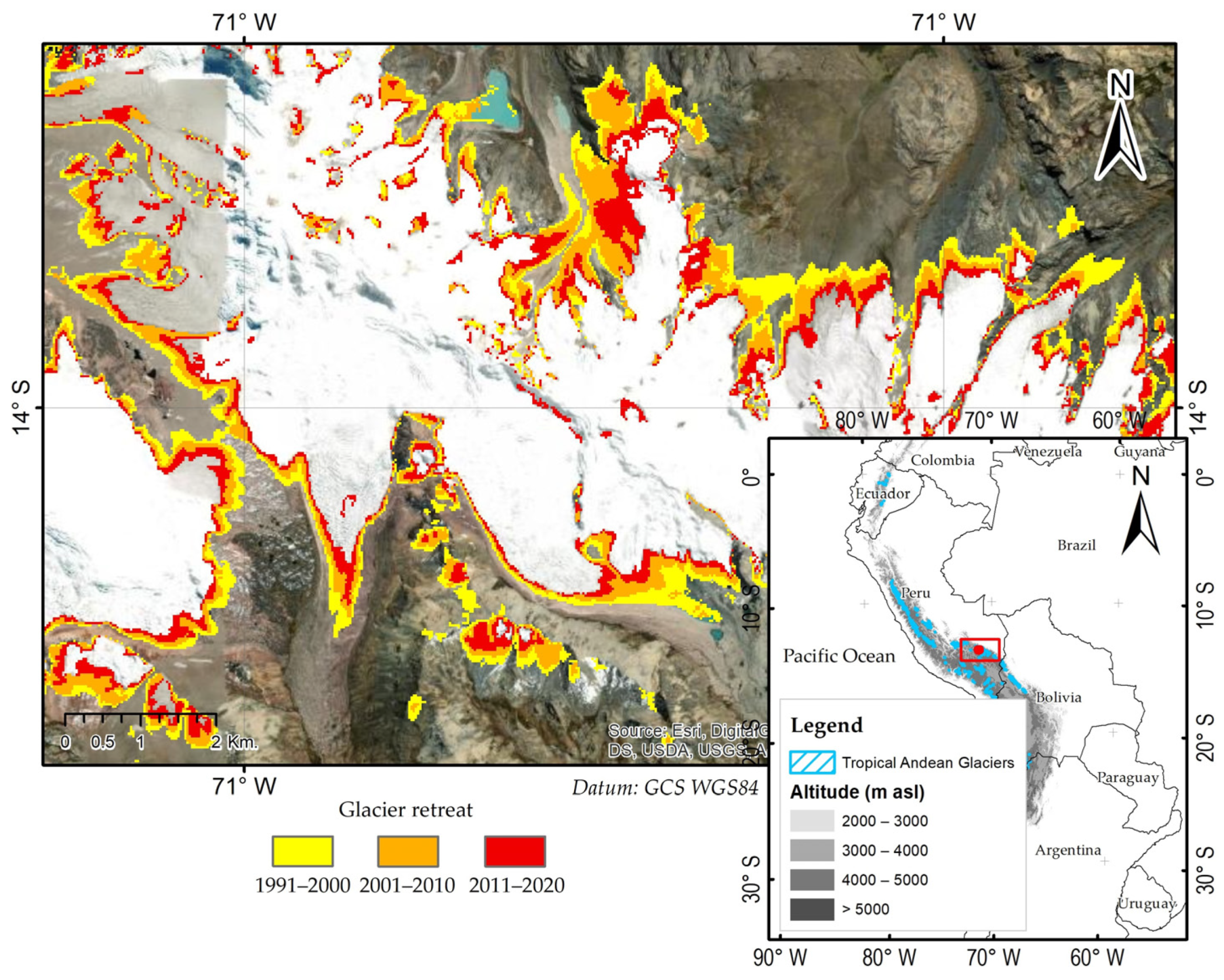
2.1. Study Area
2.2. Landsat Data
2.3. Landsat Data Processing Workflow
2.4. Images Selection and Cloud Mask
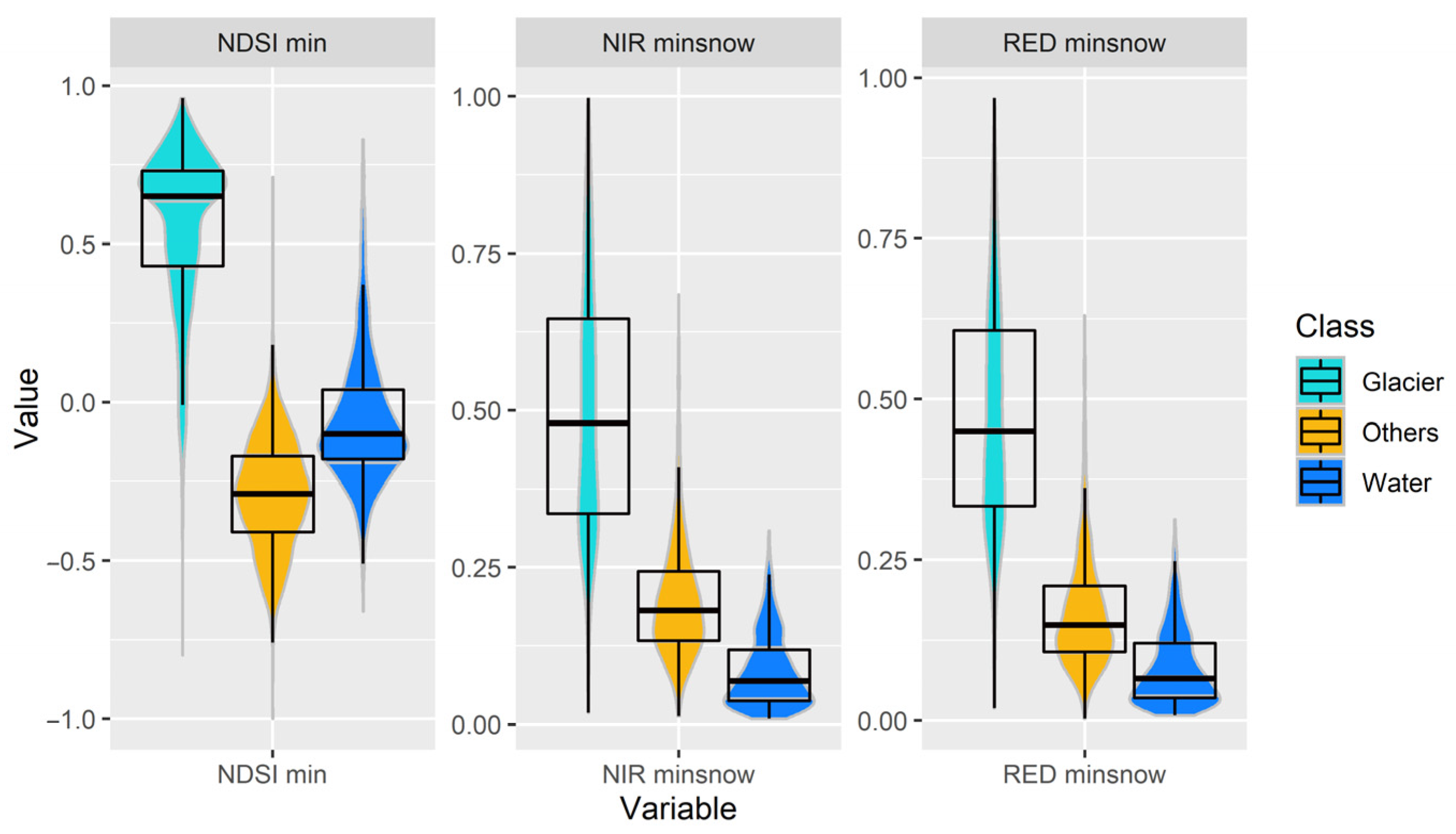
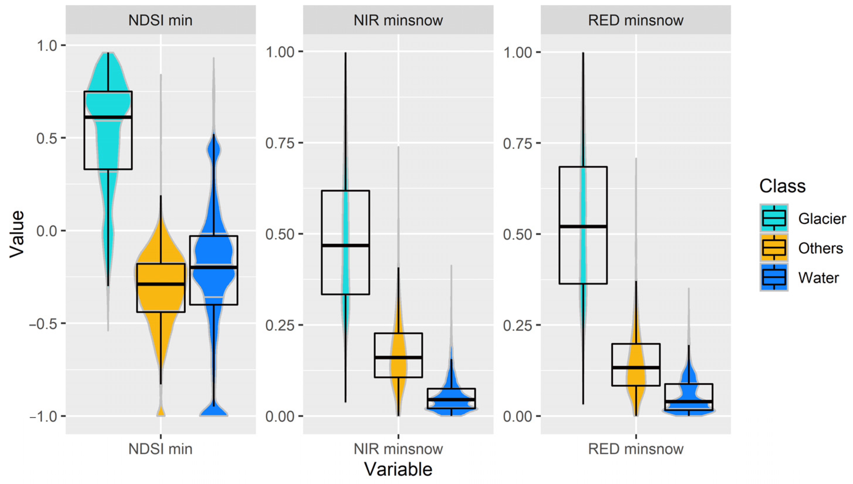
2.5. Normalized Difference Snow Index (NDSI)
2.6. The Compositing and Mosaicking of the Annual Images
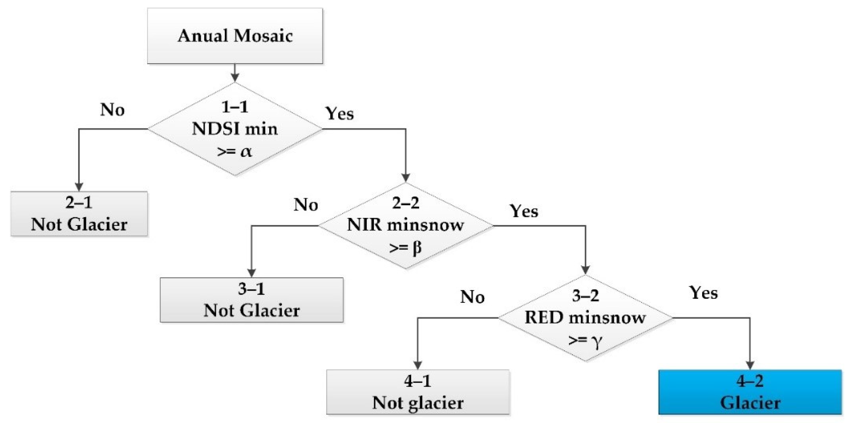
2.7. Annual Glacier Classification
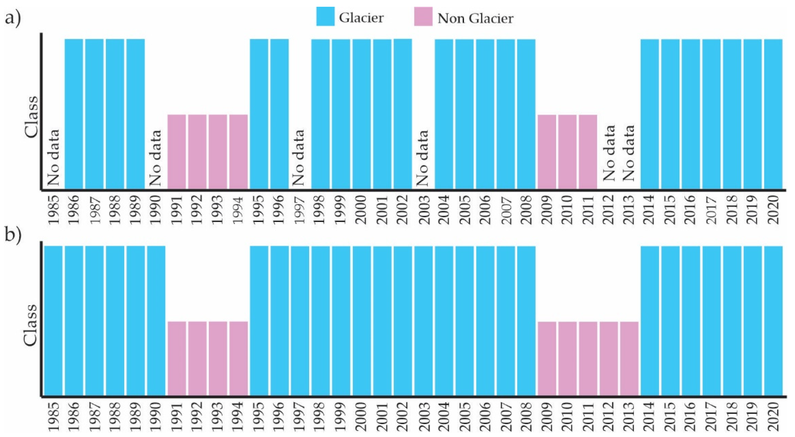
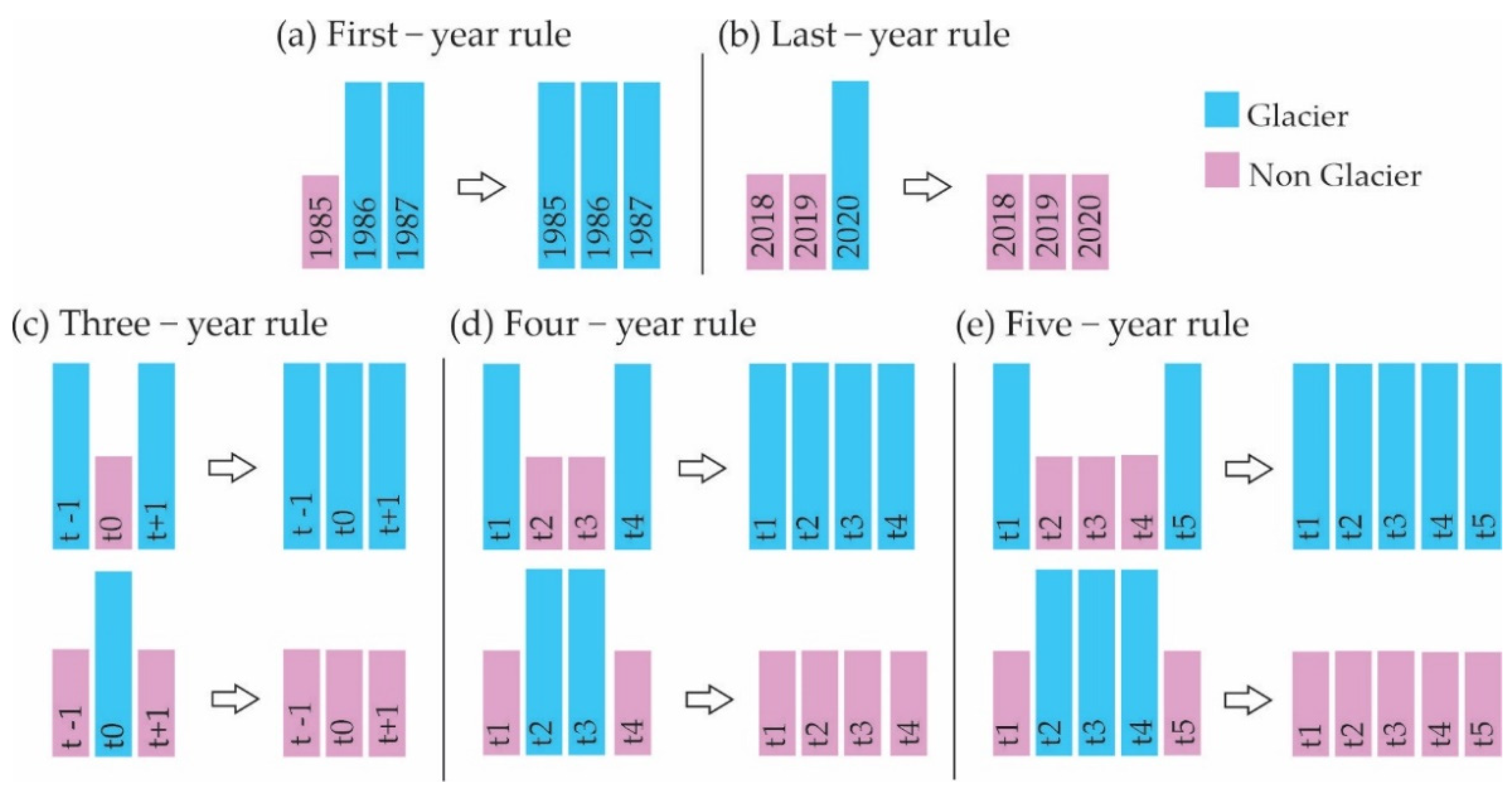
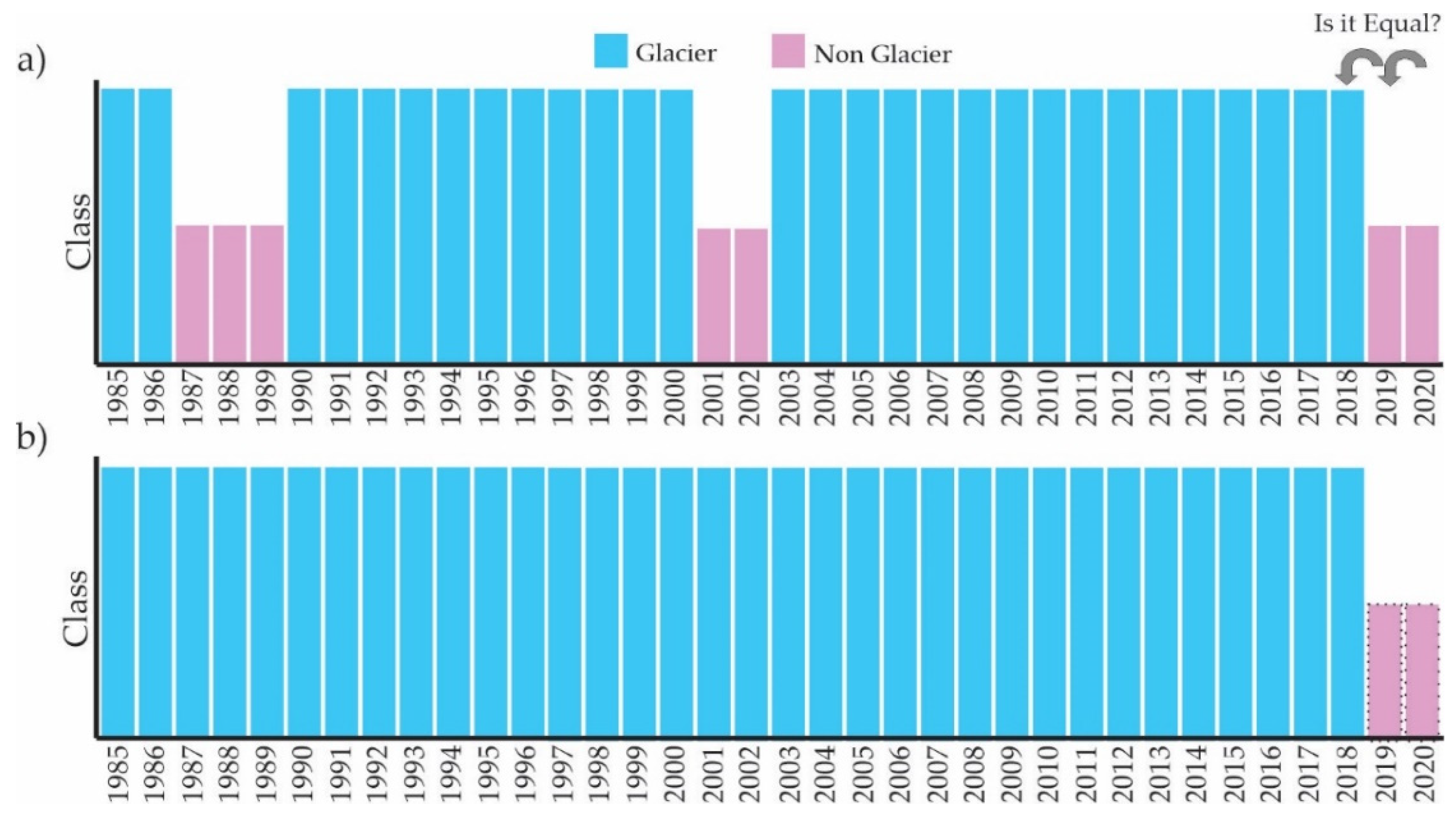
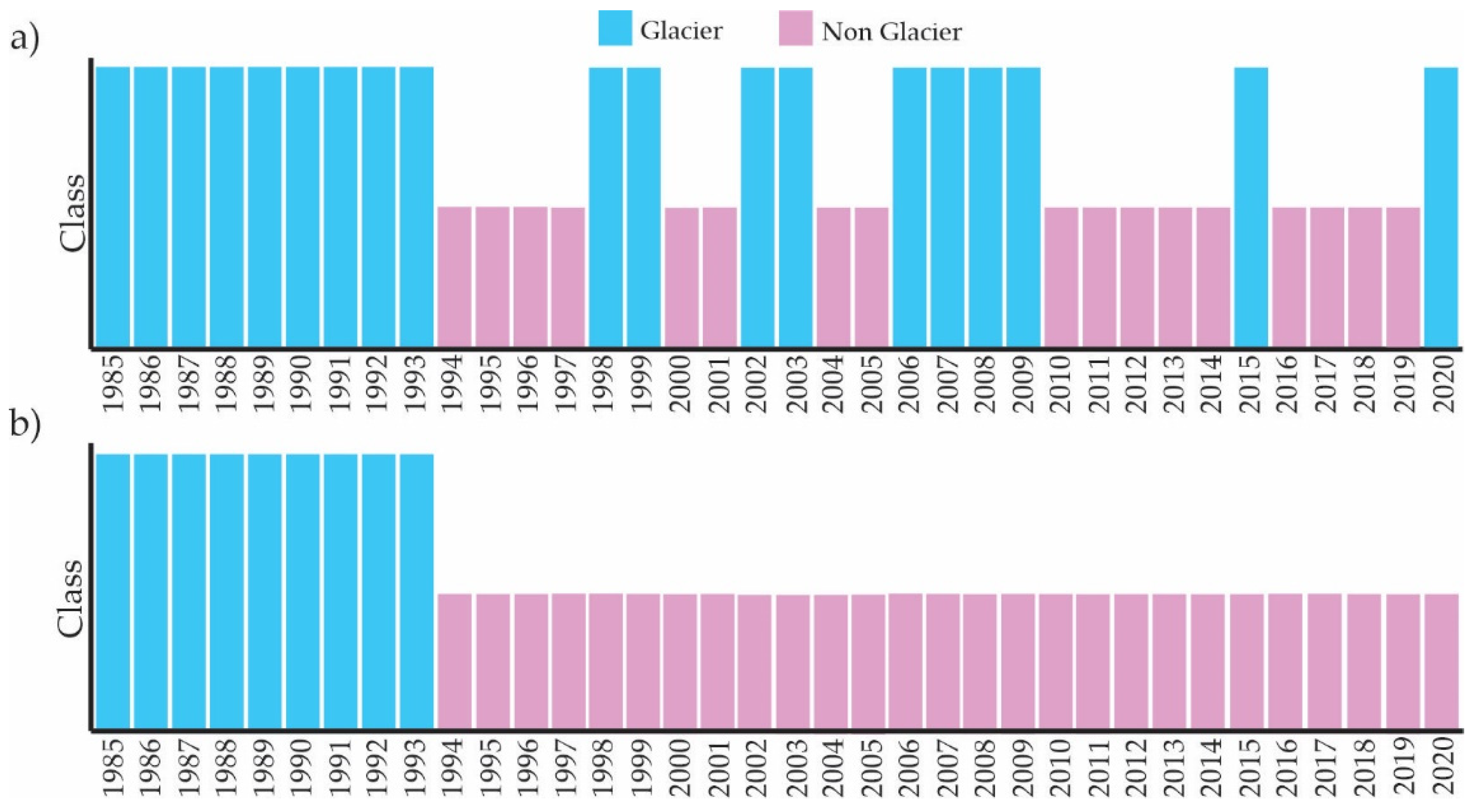
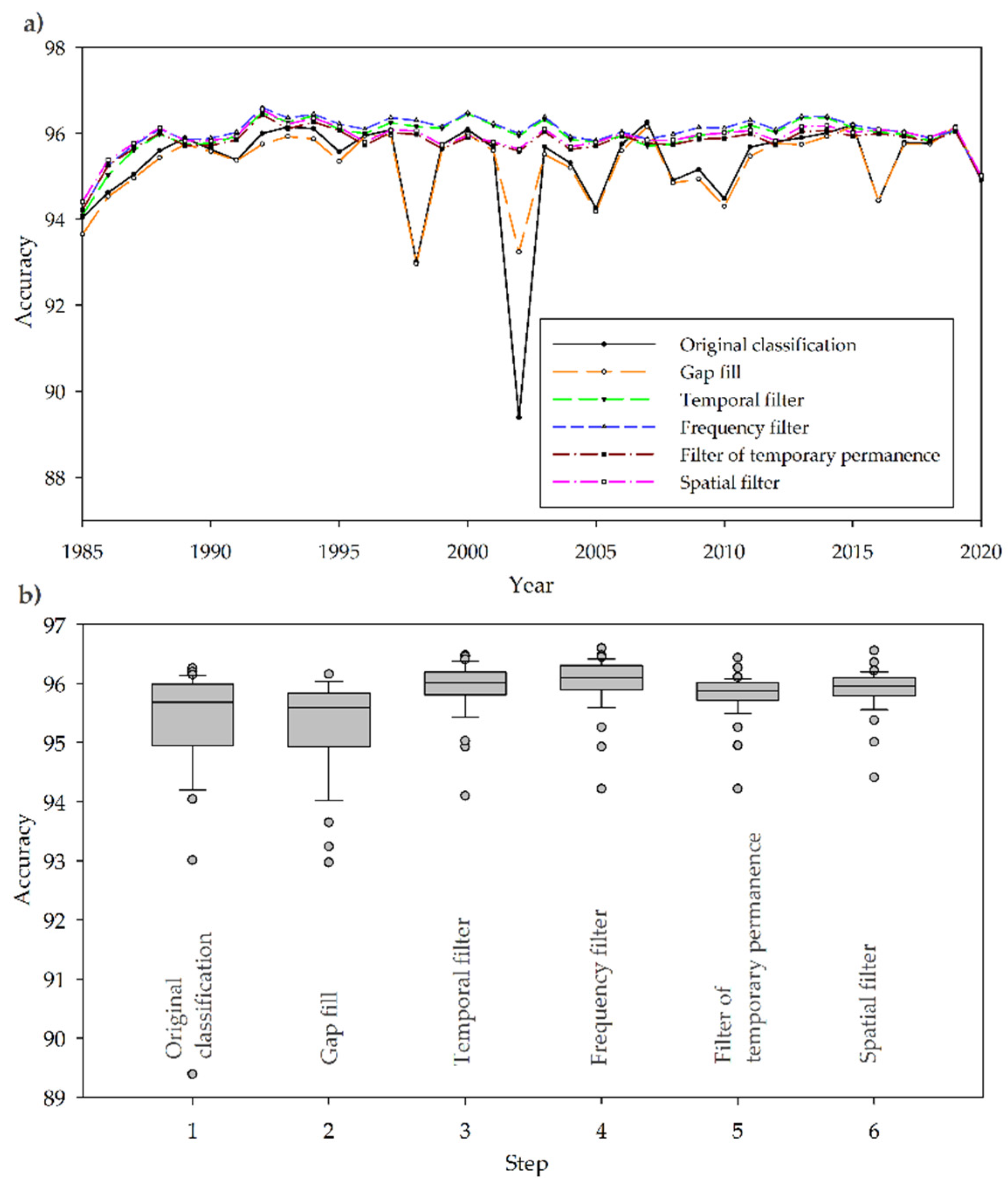
2.8. Post-Classification
- Gap-fill filter to replace information gaps due to clouds with consistent temporal classification values;
- Temporal filter to identify spurious class transitions (e.g., change in short periods from glacial to non-glacial);
- Frequency filter to identify stable pixels [51];
- Temporal permanence filter;
- Spatial filter to remove salt-and-pepper classification noise without changing the boundary of the classified patches.
2.9. Accuracy Assessment
3. Results
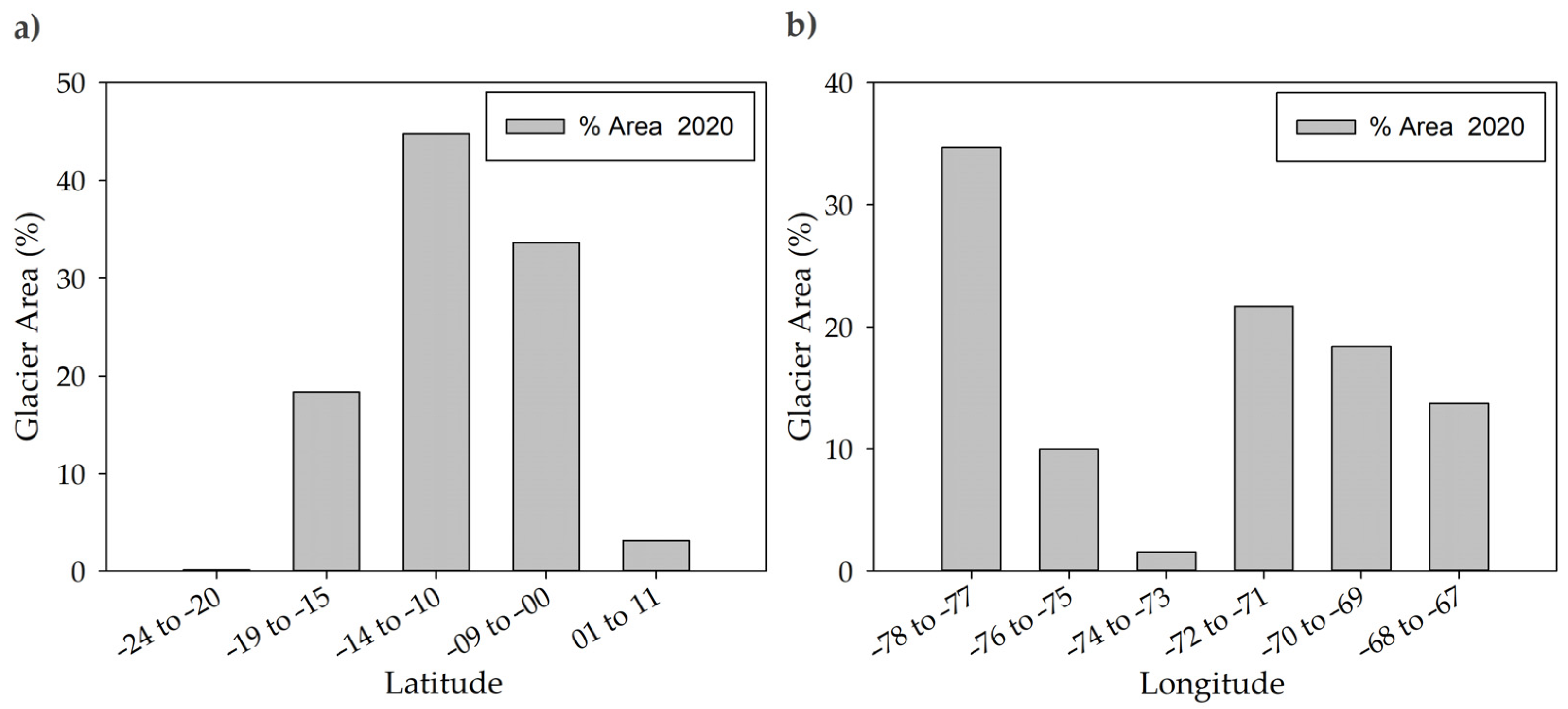
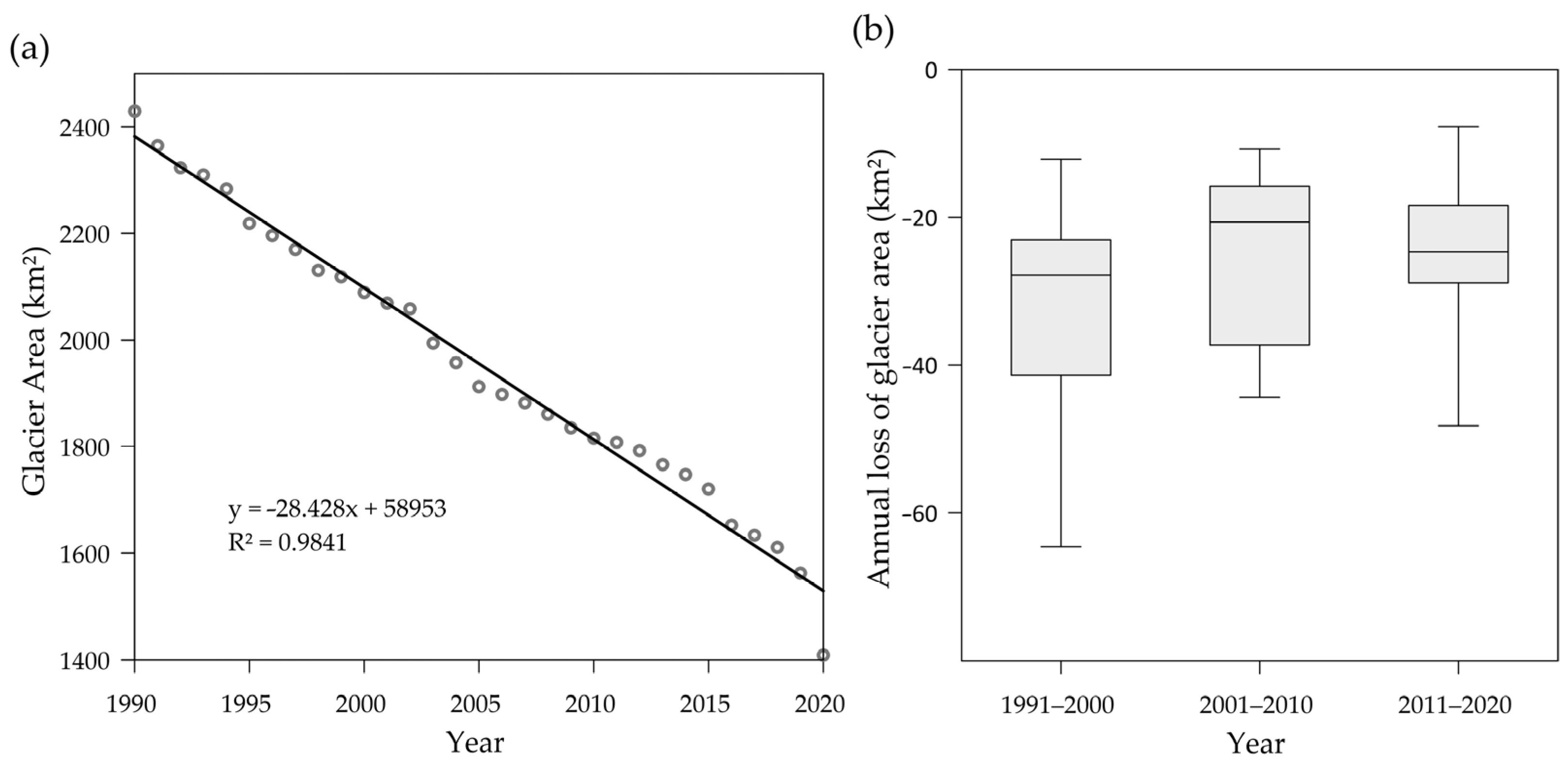
3.1. The Area Statistics of the TAGs
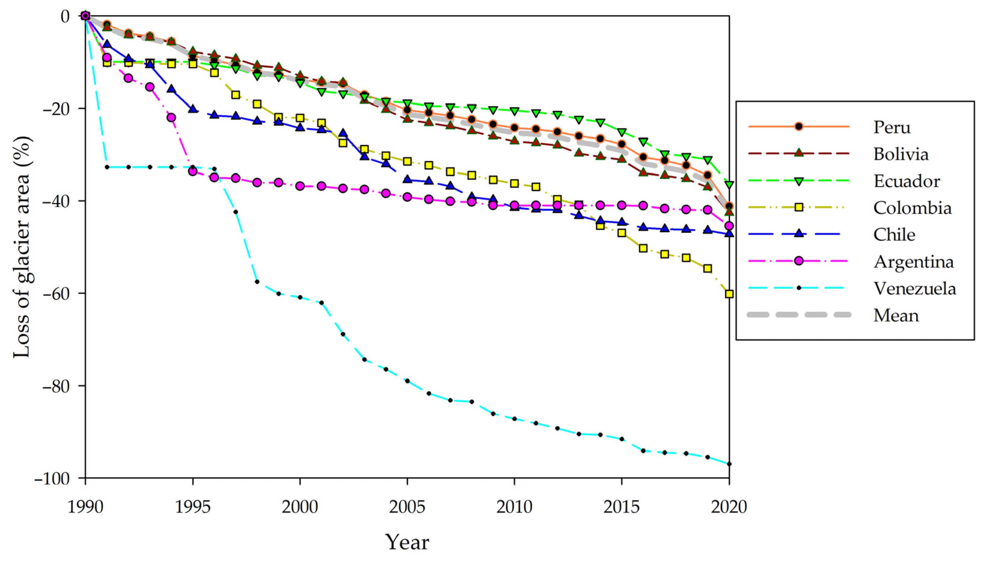
3.2. The Spatial and Temporal Patterns of the TAGs
3.3. Accuracy of the TAGs Mapping
4. Discussion
5. Conclusions
Supplementary Materials
Author Contributions
Funding
Data Availability Statement
Acknowledgments
Conflicts of Interest
References
- Huh, K.; Baraër, M.; Mark, B.; Ahn, Y. Evaluating Glacier Volume Changes since the Little Ice Age Maximum and Consequences for Stream Flow by Integrating Models of Glacier Flow and Hydrology in the Cordillera Blanca, Peruvian Andes. Water 2018, 10, 1732. [Google Scholar] [CrossRef]
- Kaser, G.; Osmaston, H. Tropical Glaciers; Cambridge University Press: Cambridge, UK, 2002; ISBN 0-521-63333-8. [Google Scholar]
- Calizaya, E.; Mejía, A.; Barboza, E.; Calizaya, F.; Corroto, F.; Salas, R.; Vásquez, H.; Turpo, E. Modelling Snowmelt Runoff from Tropical Andean Glaciers under Climate Change Scenarios in the Santa River Sub-Basin (Peru). Water 2021, 13, 3535. [Google Scholar] [CrossRef]
- Barr, I.D.; Lynch, C.M.; Mullan, D.; De Siena, L.; Spagnolo, M. Volcanic Impacts on Modern Glaciers: A Global Synthesis. Earth-Sci. Rev. 2018, 182, 186–203. [Google Scholar] [CrossRef]
- Marzeion, B.; Cogley, J.G.; Richter, K.; Parkes, D. Attribution of Global Glacier Mass Loss to Anthropogenic and Natural Causes. Science 2014, 345, 919–921. [Google Scholar] [CrossRef]
- Eyring, V.; Gillett, N.P.; Achutarao, K.; Barimalala, R.; Barreiro Parrillo, M.; Bellouin, N.; Cassou, C.; Durack, P.; Kosaka, Y.; McGregor, S. Human Influence on the Climate System: Contribution of Working Group I to the Sixth Assessment Report of the Intergovernmental Panel on Climate Change. In IPCC Sixth Assessment Report; Cambridge University Press: Cambridge, UK, 2021. [Google Scholar]
- Seehaus, T.; Malz, P.; Sommer, C.; Lippl, S.; Cochachin, A.; Braun, M. Changes of the Tropical Glaciers throughout Peru between 2000 and 2016—Mass Balance and Area Fluctuations. Cryosphere 2019, 13, 2537–2556. [Google Scholar] [CrossRef]
- Rabatel, A.; Francou, B.; Soruco, A.; Gomez, J.; Cáceres, B.; Ceballos, J.L.; Basantes, R.; Vuille, M.; Sicart, J.-E.; Huggel, C.; et al. Current State of Glaciers in the Tropical Andes: A Multi-Century Perspective on Glacier Evolution and Climate Change. Cryosphere 2013, 7, 81–102. [Google Scholar] [CrossRef]
- Bradley, R.S.; Vuille, M.; Diaz, H.F.; Vergara, W. Threats to Water Supplies in the Tropical Andes. Science 2006, 312, 1755–1756. [Google Scholar] [CrossRef]
- Veettil, B.K.; Wang, S.; Simões, J.C.; Pereira, S.F.R. Glacier Monitoring in the Eastern Mountain Ranges of Bolivia from 1975 to 2016 Using Landsat and Sentinel-2 Data. Environ. Earth Sci. 2018, 77, 452. [Google Scholar] [CrossRef]
- Vergara, W.; Deeb, A.; Valencia, A.; Bradley, R.; Francou, B.; Zarzar, A.; Grünwaldt, A.; Haeussling, S. Economic Impacts of Rapid Glacier Retreat in the Andes. Eos Trans. AGU 2007, 88, 261–264. [Google Scholar] [CrossRef]
- Escanilla-Minchel, R.; Alcayaga, H.; Soto-Alvarez, M.; Kinnard, C.; Urrutia, R. Evaluation of the Impact of Climate Change on Runoff Generation in an Andean Glacier Watershed. Water 2020, 12, 3547. [Google Scholar] [CrossRef]
- Ramírez, N.; Melfo, A.; Resler, L.M.; Llambí, L.D. The End of the Eternal Snows: Integrative Mapping of 100 Years of Glacier Retreat in the Venezuelan Andes. Arct. Antarct. Alp. Res. 2020, 52, 563–581. [Google Scholar] [CrossRef]
- Wang, S.-J.; Zhou, L.-Y. Integrated Impacts of Climate Change on Glacier Tourism. Adv. Clim. Chang. Res. 2019, 10, 71–79. [Google Scholar] [CrossRef]
- Vuille, M.; Carey, M.; Huggel, C.; Buytaert, W.; Rabatel, A.; Jacobsen, D.; Soruco, A.; Villacis, M.; Yarleque, C.; Elison Timm, O.; et al. Rapid Decline of Snow and Ice in the Tropical Andes—Impacts, Uncertainties and Challenges Ahead. Earth-Sci. Rev. 2018, 176, 195–213. [Google Scholar] [CrossRef]
- Wood, J.L.; Harrison, S.; Wilson, R.; Emmer, A.; Yarleque, C.; Glasser, N.F.; Torres, J.C.; Caballero, A.; Araujo, J.; Bennett, G.L.; et al. Contemporary Glacial Lakes in the Peruvian Andes. Glob. Planet. Chang. 2021, 204, 103574. [Google Scholar] [CrossRef]
- Baťka, J.; Vilímek, V.; Štefanová, E.; Cook, S.J.; Emmer, A. Glacial Lake Outburst Floods (GLOFs) in the Cordillera Huayhuash, Peru: Historic Events and Current Susceptibility. Water 2020, 12, 2664. [Google Scholar] [CrossRef]
- Funaki, S.; Asaoka, Y. Long-Term Change in Ablation Area of Tropical Glaciers by Landsat Data. Procedia Eng. 2016, 154, 168–175. [Google Scholar] [CrossRef][Green Version]
- Veettil, B.K.; Kamp, U. Global Disappearance of Tropical Mountain Glaciers: Observations, Causes, and Challenges. Geosciences 2019, 9, 196. [Google Scholar] [CrossRef]
- Racoviteanu, A.E.; Paul, F.; Raup, B.; Khalsa, S.J.S.; Armstrong, R. Challenges and Recommendations in Mapping of Glacier Parameters from Space: Results of the 2008 Global Land Ice Measurements from Space (GLIMS) Workshop, Boulder, CO, USA. Ann. Glaciol. 2009, 50, 53–69. [Google Scholar] [CrossRef]
- Taloor, A.K.; Kothyari, G.C.; Manhas, D.S.; Bisht, H.; Mehta, P.; Sharma, M.; Mahajan, S.; Roy, S.; Singh, A.K.; Ali, S. Spatio-Temporal Changes in the Machoi Glacier Zanskar Himalaya India Using Geospatial Technology. Quat. Sci. Adv. 2021, 4, 100031. [Google Scholar] [CrossRef]
- Albert, T.H. Evaluation of Remote Sensing Techniques for Ice-Area Classification Applied to the Tropical Quelccaya Ice Cap, Peru. Polar Geogr. 2002, 26, 210–226. [Google Scholar] [CrossRef]
- Paul, F.; Kääb, A.; Haeberli, W. Recent Glacier Changes in the Alps Observed by Satellite: Consequences for Future Monitoring Strategies. Glob. Planet. Chang. 2007, 56, 111–122. [Google Scholar] [CrossRef]
- Marta, S.; Azzoni, R.S.; Fugazza, D.; Tielidze, L.; Chand, P.; Sieron, K.; Almond, P.; Ambrosini, R.; Anthelme, F.; Alviz Gazitúa, P.; et al. The Retreat of Mountain Glaciers since the Little Ice Age: A Spatially Explicit Database. Data 2021, 6, 107. [Google Scholar] [CrossRef]
- Hansen, M.C.; Loveland, T.R. A Review of Large Area Monitoring of Land Cover Change Using Landsat Data. Remote Sens. Environ. 2012, 122, 66–74. [Google Scholar] [CrossRef]
- Veettil, B.K. Glacier Mapping in the Cordillera Blanca, Peru, Tropical Andes, Using Sentinel-2 and Landsat Data. Singap. J. Trop. Geogr. 2018, 39, 351–363. [Google Scholar] [CrossRef]
- Veetil, B. Un Análisis Comparativo Del Retroceso Glaciar En Los Andes Tropicales Usando Teledetección. Santiago Investig. Geogr. Chile 2016, 52, 3–36. [Google Scholar] [CrossRef]
- Zhu, Z. Change Detection Using Landsat Time Series: A Review of Frequencies, Preprocessing, Algorithms, and Applications. ISPRS J. Photogramm. Remote Sens. 2017, 130, 370–384. [Google Scholar] [CrossRef]
- Gorelick, N.; Hancher, M.; Dixon, M.; Ilyushchenko, S.; Thau, D.; Moore, R. Google Earth Engine: Planetary-Scale Geospatial Analysis for Everyone. Remote Sens. Environ. 2017, 202, 18–27. [Google Scholar] [CrossRef]
- Li, K.; Xu, E. High-Accuracy Continuous Mapping of Surface Water Dynamics Using Automatic Update of Training Samples and Temporal Consistency Modification Based on Google Earth Engine: A Case Study from Huizhou, China. ISPRS J. Photogramm. Remote Sens. 2021, 179, 66–80. [Google Scholar] [CrossRef]
- Souza, C.; Kirchhoff, F.; Oliveira, B.; Ribeiro, J.; Sales, M. Long-Term Annual Surface Water Change in the Brazilian Amazon Biome: Potential Links with Deforestation, Infrastructure Development and Climate Change. Water 2019, 11, 566. [Google Scholar] [CrossRef]
- Kamp, U.; Pan, C.G. Inventory of Glaciers in Mongolia, Derived from Landsat Imagery from 1989 to 2011. Geogr. Ann. Ser. A Phys. Geogr. 2015, 97, 653–669. [Google Scholar] [CrossRef]
- Paul, F.; Winsvold, S.; Kääb, A.; Nagler, T.; Schwaizer, G. Glacier Remote Sensing Using Sentinel-2. Part II: Mapping Glacier Extents and Surface Facies, and Comparison to Landsat 8. Remote Sens. 2016, 8, 575. [Google Scholar] [CrossRef]
- Burns, P.; Nolin, A. Using Atmospherically-Corrected Landsat Imagery to Measure Glacier Area Change in the Cordillera Blanca, Peru from 1987 to 2010. Remote Sens. Environ. 2014, 140, 165–178. [Google Scholar] [CrossRef]
- Kozhikkodan Veettil, B.; de Souza, S.F. Study of 40-Year Glacier Retreat in the Northern Region of the Cordillera Vilcanota, Peru, Using Satellite Images: Preliminary Results. Remote Sens. Lett. 2017, 8, 78–85. [Google Scholar] [CrossRef]
- Borja, M.O.; Camargo, R.; Moreno, N.; Turpo, E.; Villacis, S. A Long-Term Land Cover And Land Use Mapping Methodology For The Andean Amazon. In Proceedings of the 2020 IEEE Latin American GRSS & ISPRS Remote Sensing Conference (LAGIRS), Santiago, Chile, 21–26 March 2020; IEEE: Santiago, Chile, 2020; pp. 386–391. [Google Scholar]
- Crawford, C.J.; Manson, S.M.; Bauer, M.E.; Hall, D.K. Multitemporal Snow Cover Mapping in Mountainous Terrain for Landsat Climate Data Record Development. Remote Sens. Environ. 2013, 135, 224–233. [Google Scholar] [CrossRef]
- Francou, B.; Ramirez, E.; Cáceres, B.; Mendoza, J. Glacier Evolution in the Tropical Andes during the Last Decades of the 20th Century: Chacaltaya, Bolivia, and Antizana, Ecuador. AMBIO A J. Hum. Environ. 2000, 29, 416–422. [Google Scholar] [CrossRef]
- RGI Consortium. Randolph Glacier Inventory—A Dataset of Global Glacier Outlines: Version 6.0; National Snow and Ice Data Center: Boulder, CO, USA, 2017. [Google Scholar] [CrossRef]
- Sagredo, E.A.; Lowell, T.V. Climatology of Andean Glaciers: A Framework to Understand Glacier Response to Climate Change. Glob. Planet. Chang. 2012, 86–87, 101–109. [Google Scholar] [CrossRef]
- Veettil, B.K.; Wang, S.; Florêncio de Souza, S.; Bremer, U.F.; Simões, J.C. Glacier Monitoring and Glacier-Climate Interactions in the Tropical Andes: A Review. J. S. Am. Earth Sci. 2017, 77, 218–246. [Google Scholar] [CrossRef]
- Herreid, S.; Pellicciotti, F. The State of Rock Debris Covering Earth’s Glaciers. Nat. Geosci. 2020, 13, 621–627. [Google Scholar] [CrossRef]
- Shukla, A.; Gupta, R.P.; Arora, M.K. Estimation of Debris Cover and Its Temporal Variation Using Optical Satellite Sensor Data: A Case Study in Chenab Basin, Himalaya. J. Glaciol. 2009, 55, 444–452. [Google Scholar] [CrossRef]
- Falaschi, D.; Bolch, T.; Lenzano, M.G.; Tadono, T.; Lo Vecchio, A.; Lenzano, L. New Evidence of Glacier Surges in the Central Andes of Argentina and Chile. Prog. Phys. Geogr. Earth Environ. 2018, 42, 792–825. [Google Scholar] [CrossRef]
- Wulder, M.A.; White, J.C.; Loveland, T.R.; Woodcock, C.E.; Belward, A.S.; Cohen, W.B.; Fosnight, E.A.; Shaw, J.; Masek, J.G.; Roy, D.P. The Global Landsat Archive: Status, Consolidation, and Direction. Remote Sens. Environ. 2016, 185, 271–283. [Google Scholar] [CrossRef]
- United States Geological Survey. Landsat Collection 1 Surface Reflectance. 2021. Available online: https://www.usgs.gov/landsat-missions/landsat-collection-1-surface-reflectance (accessed on 1 March 2021).
- Paul, F.; Bolch, T.; Kääb, A.; Nagler, T.; Nuth, C.; Scharrer, K.; Shepherd, A.; Strozzi, T.; Ticconi, F.; Bhambri, R.; et al. The Glaciers Climate Change Initiative: Methods for Creating Glacier Area, Elevation Change and Velocity Products. Remote Sens. Environ. 2015, 162, 408–426. [Google Scholar] [CrossRef]
- NASA. Crisis Mapping Toolkit (CMT) V1; Environmental Science Earth Air Space Exoplanet; NASA: Washington, DC, USA, 2021.
- Huang, L.; Li, Z.; Zhou, J.M.; Zhang, P. An Automatic Method for Clean Glacier and Nonseasonal Snow Area Change Estimation in High Mountain Asia from 1990 to 2018. Remote Sens. Environ. 2021, 258, 112376. [Google Scholar] [CrossRef]
- Housman, I.; Chastain, R.; Finco, M. An Evaluation of Forest Health Insect and Disease Survey Data and Satellite-Based Remote Sensing Forest Change Detection Methods: Case Studies in the United States. Remote Sens. 2018, 10, 1184. [Google Scholar] [CrossRef]
- Souza, C.M.Z.; Shimbo, J.; Rosa, M.R.; Parente, L.L.; Alencar, A.A.; Rudorff, B.F.T.; Hasenack, H.; Matsumoto, M.; Ferreira, L.G.; Souza-Filho, P.W.M.; et al. Reconstructing Three Decades of Land Use and Land Cover Changes in Brazilian Biomes with Landsat Archive and Earth Engine. Remote Sens. 2020, 12, 2735. [Google Scholar] [CrossRef]
- Hall, D.K.; Riggs, G.A. Normalized-Difference Snow Index (NDSI). In Encyclopedia of Snow, Ice and Glaciers; Singh, V.P., Singh, P., Haritashya, U.K., Eds.; Encyclopedia of Earth Sciences Series; Springer: Dordrecht, The Netherlands, 2011; pp. 779–780. ISBN 978-90-481-2641-5. [Google Scholar]
- Macander, M.J.; Swingley, C.S.; Joly, K.; Raynolds, M.K. Landsat-Based Snow Persistence Map for Northwest Alaska. Remote Sens. Environ. 2015, 163, 23–31. [Google Scholar] [CrossRef]
- Winsvold, S.H.; Kaab, A.; Nuth, C. Regional Glacier Mapping Using Optical Satellite Data Time Series. IEEE J. Sel. Top. Appl. Earth Obs. Remote Sens. 2016, 9, 3698–3711. [Google Scholar] [CrossRef]
- Congalton, R.G.; Green, K. Assessing the Accuracy of Remotely Sensed Data: Principles and Practices; CRC Press: Boca Raton, FL, USA, 2009; ISBN 978-1-4200-5512-2. [Google Scholar]
- Donchyts, G.; Llano; Baart, F.; Hereñú, D.; Braaten, J. Gee-Community/Qgis-Earthengine-Plugin: V0.0.4 (0.0.4-Alpha-Doi); GitHub: San Francisco, CA, USA, 2022. [Google Scholar] [CrossRef]
- Llano, X.C. AcATaMa—QGIS Plugin for Accuracy Assessment of Thematic Maps. 2019. Available online: https://github.com/SMByC/AcATaMa (accessed on 1 March 2021).
- Olofsson, P.; Foody, G.M.; Herold, M.; Stehman, S.V.; Woodcock, C.E.; Wulder, M.A. Good Practices for Estimating Area and Assessing Accuracy of Land Change. Remote Sens. Environ. 2014, 148, 42–57. [Google Scholar] [CrossRef]
- Olson, D.L.; Delen, D. Advanced Data Mining Techniques; Springer: Berlin/Heidelberg, Germany, 2008; ISBN 978-3-540-76916-3. [Google Scholar]
- Rittger, K.; Painter, T.H.; Dozier, J. Assessment of Methods for Mapping Snow Cover from MODIS. Adv. Water Resour. 2013, 51, 367–380. [Google Scholar] [CrossRef]
- Randall, D.A.; Wood, R.A.; Bony, S.; Colman, R.; Fichefet, T.; Fyfe, J.; Kattsov, V.; Pitman, A.; Shukla, J.; Srinivasan, J.; et al. Climate Models and Their Evaluation. In Climate Change 2007: The Physical Science Basis. Contribution of Working Group I to the Fourth Assessment Report of the IPCC (FAR); Cambridge University Press: Cambridge, UK, 2007; pp. 589–662. [Google Scholar]
- de Magalhães, N.; Evangelista, H.; Condom, T.; Rabatel, A.; Ginot, P. Amazonian Biomass Burning Enhances Tropical Andean Glaciers Melting. Sci. Rep. 2019, 9, 16914. [Google Scholar] [CrossRef]
- Barboza Castillo, E.; Turpo Cayo, E.Y.; de Almeida, C.M.; Salas López, R.; Rojas Briceño, N.B.; Silva López, J.O.; Barrena Gurbillón, M.Á.; Oliva, M.; Espinoza-Villar, R. Monitoring Wildfires in the Northeastern Peruvian Amazon Using Landsat-8 and Sentinel-2 Imagery in the GEE Platform. IJGI 2020, 9, 564. [Google Scholar] [CrossRef]
- da Rocha, N.S.; Veettil, B.K.; Grondona, A.; Rolim, S. The Influence of ENSO and PDO on Tropical Andean Glaciers and Their Impact on the Hydrology of the Amazon Basin. Singap. J. Trop. Geogr. 2019, 40, 346–360. [Google Scholar] [CrossRef]
- Vuille, M.; Francou, B.; Wagnon, P.; Juen, I.; Kaser, G.; Mark, B.G.; Bradley, R.S. Climate Change and Tropical Andean Glaciers: Past, Present and Future. Earth-Sci. Rev. 2008, 89, 79–96. [Google Scholar] [CrossRef]
- Schauwecker, S.; Rohrer, M.; Huggel, C.; Endries, J.; Montoya, N.; Neukom, R.; Perry, B.; Salzmann, N.; Schwarb, M.; Suarez, W. The Freezing Level in the Tropical Andes, Peru: An Indicator for Present and Future Glacier Extents: The Freezing Level in the Tropical Andes. J. Geophys. Res. Atmos. 2017, 122, 5172–5189. [Google Scholar] [CrossRef]
- Bradley, R.S.; Keimig, F.T.; Diaz, H.F.; Hardy, D.R. Recent Changes in Freezing Level Heights in the Tropics with Implications for the Deglacierization of High Mountain Regions. Geophys. Res. Lett. 2009, 36, L17701. [Google Scholar] [CrossRef]
- Yarleque, C.; Vuille, M.; Hardy, D.R.; Timm, O.E.; De la Cruz, J.; Ramos, H.; Rabatel, A. Projections of the Future Disappearance of the Quelccaya Ice Cap in the Central Andes. Sci. Rep. 2018, 8, 15564. [Google Scholar] [CrossRef]


| Period (# Year) | Minimum (km2) | Maximum (km2) | Mean | Standard Deviation (s) |
|---|---|---|---|---|
| (km2/Year) | ||||
| 1991–2000 | 2089.20 | 2364.80 | 2220.35 | 95.58 |
| 2001–2010 | 1815.57 | 2069.41 | 1928.37 | 89.03 |
| 2011–2020 | 1409.12 | 1807.83 | 1670.35 | 123.14 |
| Country | Glacier Area (km2) | |||
|---|---|---|---|---|
| 1990 | 2000 | 2010 | 2020 | |
| Peru | 1743.45 | 1503.67 | 1320.85 | 1025.29 |
| Bolivia | 499.58 | 434.75 | 364.02 | 286.69 |
| Ecuador | 86.10 | 73.70 | 68.52 | 54.78 |
| Colombia | 77.21 | 60.18 | 49.21 | 30.73 |
| Chile | 20.77 | 15.73 | 12.15 | 10.96 |
| Argentina | 1.15 | 0.73 | 0.68 | 0.63 |
| Venezuela | 1.12 | 0.44 | 0.14 | 0.03 |
| Total | 2429.38 | 2089.20 | 1815.57 | 1409.12 |
Publisher’s Note: MDPI stays neutral with regard to jurisdictional claims in published maps and institutional affiliations. |
© 2022 by the authors. Licensee MDPI, Basel, Switzerland. This article is an open access article distributed under the terms and conditions of the Creative Commons Attribution (CC BY) license (https://creativecommons.org/licenses/by/4.0/).
Share and Cite
Turpo Cayo, E.Y.; Borja, M.O.; Espinoza-Villar, R.; Moreno, N.; Camargo, R.; Almeida, C.; Hopfgartner, K.; Yarleque, C.; Souza, C.M., Jr. Mapping Three Decades of Changes in the Tropical Andean Glaciers Using Landsat Data Processed in the Earth Engine. Remote Sens. 2022, 14, 1974. https://doi.org/10.3390/rs14091974
Turpo Cayo EY, Borja MO, Espinoza-Villar R, Moreno N, Camargo R, Almeida C, Hopfgartner K, Yarleque C, Souza CM Jr. Mapping Three Decades of Changes in the Tropical Andean Glaciers Using Landsat Data Processed in the Earth Engine. Remote Sensing. 2022; 14(9):1974. https://doi.org/10.3390/rs14091974
Chicago/Turabian StyleTurpo Cayo, Efrain Yury, Maria Olga Borja, Raul Espinoza-Villar, Nicole Moreno, Rodney Camargo, Claudia Almeida, Kathrin Hopfgartner, Christian Yarleque, and Carlos M. Souza, Jr. 2022. "Mapping Three Decades of Changes in the Tropical Andean Glaciers Using Landsat Data Processed in the Earth Engine" Remote Sensing 14, no. 9: 1974. https://doi.org/10.3390/rs14091974
APA StyleTurpo Cayo, E. Y., Borja, M. O., Espinoza-Villar, R., Moreno, N., Camargo, R., Almeida, C., Hopfgartner, K., Yarleque, C., & Souza, C. M., Jr. (2022). Mapping Three Decades of Changes in the Tropical Andean Glaciers Using Landsat Data Processed in the Earth Engine. Remote Sensing, 14(9), 1974. https://doi.org/10.3390/rs14091974