Article

Monitoring River Basin Development and Variation in Water Resources in Transboundary Imjin River in North and South Korea Using Remote Sensing

1
Department of Civil and Environmental Engineering, University of Houston, Houston, TX 77204, USA
2
Hydrological Sciences Laboratory, NASA Goddard Space Flight Center, Greenbelt, MD 20771, USA
3
Science Systems and Applications, Inc., Lanham, MD 20706, USA
4
Water Resources Satellite Research Center, K-Water Institute, K-Water, Daejeon 34350, Korea
5
Department of Civil and Environmental Engineering, University of Washington, WA 98195, USA
6
Jet Propulsion Laboratory, California Institute of Technology, Pasadena, CA 91109, USA
7
Earth System Science Interdisciplinary Center, University of Maryland, College Park, MD 20740, USA
*
Author to whom correspondence should be addressed.
Remote Sens. 2020, 12(1), 195; https://doi.org/10.3390/rs12010195
Submission received: 25 November 2019 / Revised: 31 December 2019 / Accepted: 31 December 2019 / Published: 5 January 2020
(This article belongs to the Special Issue Remote Sensing of Geopolitics)

Abstract

:
This paper presents methods of monitoring river basin development and water variability for the transboundary river in North and South Korea. River basin development, such as dams and water infrastructure in transboundary rivers, can be a potential factor of tensions between upstream and downstream countries since dams constructed upstream can adversely affect downstream riparians. However, because most of the information related to North Korea has been limited to the public, the information about dams constructed and their locations were inaccurate in many previous studies. In addition, water resources in transboundary rivers can be exploited as a political tool. Specifically, due to the unexpected water release from the Hwanggang Dam, upstream of the transboundary Imjin River in North and South Korea, six South Koreans died on 6 September 2009. The Imjin River can be used as a political tool by North Korea, and seven events were reported as water conflicts in the Imjin River from 2001 to 2016. In this paper, firstly, we have updated the information about the dams constructed over the Imjin River in North Korea using multi-temporal images with a high spatial resolution (15–30 cm) obtained from Google Earth. Secondly, we analyzed inter- and intra-water variability over the Hwanggang Reservoir using open-source images obtained from the Global Surface Water Explorer. We found a considerable change in water surface variability before and after 2008, which might result from the construction of the Hwanggang Dam. Thirdly, in order to further investigate intra-annual water variability, we present a method monitoring water storage changes of the Hwanggang Reservoir using the area-elevation curve (AEC), which was derived from multi-sensor Synthetic Aperture Radar (SAR) images (Sentinel-1A and -1B) and the Shuttle Radar Topography Mission (SRTM) Digital Elevation Model (DEM). Since many previous studies for estimating water storage change have depended on satellite altimetry dataset and optical images for deriving AEC, the method adopted in this study is the only application for such inaccessible areas since no altimetry ground track exists for the Hwanggang Reservoir and because clouds can block the study area for wet seasons. Moreover, this study has newly proven that unexpected water release can occur in dry seasons because the water storage in the Hwanggang Reservoir can be high enough to conduct a release that can be used as a geopolitical tool. Using our method, potential risks can be mitigated, not in response to a water release, but based on pre-event water storage changes in the Hwanggang Reservoir.

Graphical Abstract

1. Introduction

Two hundred and sixty-one rivers flow across more than two countries. These rivers are referred to as transboundary rivers and create international river basins (IRBs) which cover 45% of the global land surface excluding Antarctica [1]. Many studies have revealed that a wide range of conflicts exists in IRBs due mostly to increasing demands of water [2,3,4,5]. Anthropogenic interventions on the water cycle (e.g., dam construction for water storage or water withdrawals for irrigation purposes) directly affect downstream countries [6]. Historically, water management in IRBs has been challenging due to tensions on riparian water rights and limited institutional efforts between upstream and downstream countries [1,7]. For example, institutions of transboundary rivers have been established over only 70 IRBs, and the rest, including the Imjin River that flows through North and South Korea, are likely to be conflict zones for water security [8,9].
River basin development, such as the construction of dams and water infrastructure, helps mitigate water variability resulting from inter- and intra-annual variations of water resources (e.g., providing water in drought or storing water in floods), but the construction of large dams in upstream countries can cause potential hydro-political tensions since it leads to substantial changes in available water resources, which can adversely affect downstream riparian countries [10]. Therefore, it is important to have accurate and updated information about dams constructed upstream countries. This is evident in the Imjin Basin, where North Korea’s construction of dams, such as the Hwanggang Dam and the April 5th Dams, has caused a decrease in river discharge downstream [11]. However, many previous studies over the Imjin Basin [11,12,13,14,15,16] have reported inaccurate information about dams constructed in North Korea (e.g., inaccurate location and wrong information about dam constructions and destructions). This is likely because these dams are in an inaccessible region, North Korea. Therefore, any investigation of dams constructed and destroyed would remain incomplete.
On the other hand, water resources in transboundary rivers can be exploited as a geopolitical tool. According to Gleick and Heberger [17], the number of reported water-related conflicts was 109 from 2000 to 2012. Among them, 24 events were transnational disputes. More than 70% of this transnational dispute was a development dispute, which is generally related to water scarcity, water quality, and water-energy-food nexus [18]. For example, more than 40 people had died after clashes over scarce water, livestock, and grazing land in the border between Ethiopia and Kenya [17,19]. In 2007, due to Israel’s sanctions against Gaza, 15% of Gaza’s population (225,000 people) was not provided an adequate amount of drinking water because Gaza lacked sufficient fuel to maintain the water supply system [17,20]. On the other hand, violence over water resources can be represented by water release without early warning. For example, due to the unexpected release of 40 million cubic meters (0.4 km3) of water from the Hwanggang Dam, at least six South Koreans died on September 6, 2009, and the estimated property damage was approximately $500,000 downstream Imjin River [15,17,21]. This is an exceptional water-related conflict since it was one of the few cases that utilized water for political reasons.
North and South Korea were divided after the Korean War (25 June 1950–27 July 1953). Between North and South Korea, the demilitarized zone (DMZ), which is a buffer zone of the national boundary (250 km long and about 4 km wide), exists. DMZ is considered as the nature reserve, which is protected by fortified fences and landmines [22]. However, the Imjin River flows southward from North Korea into South Korea without any interference from the DMZ. Therefore, as previously mentioned, the Imjin River can be used as a geopolitical tool by North Korea. Lee [23] summarized chronology of water conflicts related to the Imjin River between North and South Korea from 2001 to 2016 (Table 1). Lee [23] claimed that North Korea has utilized the Imjin River as a political and/or military tool after 2001. He examined seven water conflicts that occurred in the Imjin River. Six conflicts occurred due to the unexpected water releases from dams located in North Korea. One conflict resulted from landmines that were moved from upstream to downstream Imjin River. This incident had killed one civilian and wounded another downstream Imjin River in South Korea. Given the frequency and severity of these water releases, it is important to monitor unexpected water releases and water storage changes from dams upstream of the Imjin River.
Previous studies have shown that satellite data can be used to obtain water storage changes in lakes or reservoirs. Gao [24] summarized two representative such methods: (1) relating in-situ storage data and remotely-sensed water levels or areas and (2) multiplying the water level changes from satellite altimetry and water surface areas from satellite images. Zhang et al. [25] estimated water storage variations in Lake Dongting in China using a rating curve between water levels derived from Topex/Poseidon (T/P) altimetry data and water storages from in-situ water storage data. Salami and Nnadi [26] also estimated storages of the Kainji reservoir in Nigeria based on a high coefficient of determination (R2 > 0.90) between altimetry-derived water levels and reservoir storages derived from a hydrologic mass balance with in-situ data (inflows, reservoir water levels, evaporation, and precipitation). Gao et al. [27] obtained storage changes of 34 reservoirs around the world by combining Moderate Resolution Imaging Spectroradiometer (MODIS)-derived surface water areas and altimetry-derived water level changes. Getirana et al. [28] evaluated different techniques to rebuild bathymetry and derive absolute water storage variability in reservoirs by combining the Shuttle Radar Topography Mission (SRTM) Digital Elevation Model (DEM), radar altimetry data, and Landsat-based water extents.
In the aforementioned remote sensing methods, the temporal resolution of the estimated reservoir water storage depends on the revisit time of satellite. For example, to derive the water level of the reservoir, Zhang et al. [25] used T/P altimetry that orbited on a 10-day repeat cycle. Salami and Nnadi [26] also used T/P and Envisat altimetry with 10-day and 35-day repeat cycles, respectively. Gao et al. [27] used MODIS 16-day 250 m vegetation products to estimate surface water areas. Therefore, their temporal resolutions of reservoir storage changes are limited to 10 to 35 days. Moreover, in the case of using optical images, such as MODIS and Landsat, to derive water surface areas, cloud cover often obscures optical sensors during the wet season. Therefore, those sensors might not be appropriate to derive surface water areas of the Imjin Basin since the average precipitation of the Imjin Basin is approximately 1,273 mm, which is mostly concentrated in the wet season (15 May to 15 October) [29]. Since the methods used in [7,25,26,27,28] are insufficient and unreliable for the inaccessible region, the Hwanggang Reservoir, due to the above reasons, it is required to apply a new method for obtaining water storage changes.
In order to monitor river basin development and variation in water resources in the transboundary Imjin River, this paper provides updated information of dams constructed and destroyed in the Imjin Basin and analyzes the inter- and intra-annual variations in hydrologic variables, including water levels, surface water areas, storage changes, and precipitation over the Hwanggang Reservoir. Firstly, updated information on the dams is obtained by identifying constructions and destructions of the dams using multi-temporal historical satellite imagery with a spatial resolution of 15–30 cm obtained from Google Earth. Secondly, the changes of water extents of the Imjin Basin near the Hwanggang Dam are examined with the Global Surface Water Explorer (https://global-surface-water.appspot.com), which provides the temporal distribution of water surfaces at the global scale over the past 3.5 decades [30]. Thirdly, we conducted detailed analyses of water storage variations over the Hwanggang Reservoir for the year 2017 using remotely sensed data with C-band Sentinel-1A and -1B Synthetic Aperture Radar (SAR) images and SRTM DEM. To do so, the amount of necessary water storage to conduct an unexpected water release from the Hwanggang Dam is estimated. Using this approach, potential risks resulting from unexpected water releases can be mitigated as authorities can react, not in response to a water release, but based on pre-event water storage changes in the Hwanggang Reservoir.

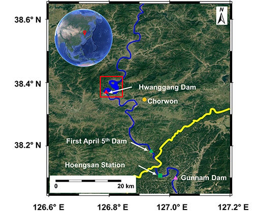
2. Monitoring River Basin Development of the Imjin River in North Korea

The locations of the Imjin River and the border between North and South Korea are shown in Figure 1. The total length of the Imjin River is about 254 km. It flows southward through Chorwon of North Korea into Gyeonggi Province of South Korea, then joins the Han River downstream of Seoul, and finally flows into the Yellow Sea. The drainage area of the Imjin Basin is about 8117 km2. The length and area of the Imjin Basin included in North Korea are 162 km (64.0%) and 5108 km2 (62.9%), respectively [29].
As previously mentioned, the inaccurate information of dams constructed upstream of the Imjin River has been found in many published papers [11,12,13,14,15,16]. As can be seen in Figure 1, the locations for the First, Second, and Third April 5th Dams were wrongly illustrated in [12,13]. Although Song et al. [11] showed the satellite images of the First and Second April 5th Dams, no information about the acquisition dates of the images was provided. Therefore, accurate and updated information about dams, constructed or destroyed upstream of the Imjin River, is required for water resources management in the transboundary river between North and South Korea.
According to previous studies, four April 5th Dams exist in the Imjin River. Among the four dams, two dams are located downstream of the Hwanggang Dam. The First and Second April 5th Dams are small-size hydropower dams constructed in 2001 (estimated) with a capacity of 0.02 km3 (20 million ton) and 0.0077 km3 (7.7 million ton), respectively [12,16]. The Hwanggang Dam is a multi-purpose (e.g., storage, flood control, and power generation) dam constructed in 2007 (estimated) with a capacity of 0.35 km3 (350 million ton) [12,15,16,31]. As can be seen in Table 1, North Korea’s unexpected water releases from the First April 5th Dam and Hwanggang Dam were the main causes of the water conflicts between North and South Korea.
On the other hand, the information of dams, constructed or destroyed, has not been updated. To examine the current dams located upstream in the Imjin River, we checked the historical imagery of Google Earth, which provides multi-temporal images with high resolution [32,33]. We checked more than ten images obtained from different dates from 2002 to 2019. Figure 2, Figure 3, Figure 4, Figure 5 and Figure 6 show the selected images of the First, Second, Third, and Fourth April 5th Dams, and Hwanggang Dam, respectively. As confirmed in previous articles, the First and Second April 5th Dams can be seen in 2005 (Figure 2a) and 2002 (Figure 3a). Note that both dams were constructed in 2001 (estimated). However, the Second April 5th Dam cannot be found in 2013 (Figure 3c), and we can imagine that the dam could have been destroyed sometime between 2011 and 2013. In addition, as can be seen in Figure 4a and Figure 5a, the Third and Fourth April 5th Dams were identified in 2002. However, the Third and Fourth April 5th Dams cannot be found after 2011 and 2017, respectively. This implies that the two dams could have been destroyed before 2011 and 2017, respectively. In the case of the Hwanggang Dam, we can imagine that the dam still exists at present, as can be seen in Figure 6. This finding reveals the current dams that existed over the Imjin River in North Korea are the Hwanggang Dam and the First April 5th Dam, whereas most previous studies have claimed that the First, Second, Third, and Fourth April 5th Dams, and the Hwanggang Dam still exist.

3. Monitoring Water Variability Using Remote Sensing

3.1. Traditional Method for Monitoring Water Variability over the Imjin River

The closest in-situ stream gauge station is the Hoengsan station in South Korea (Lat 38.1108° N, Lon 126.9606° E), which is about 47 km away from the Hwanggang Dam (see Figure 1 for its location). In order to respond to North Korea’s unexpected water release, South Korea constructed a multi-purpose dam, Gunnam Dam, in 2010 with a capacity of 0.076 km3 (70.6 million ton, 1/5 capacity of the Hwannggang Dam) [11,15].
Table 2 shows four stages of alerts for the downstream Imjin River using the water levels measured at the Hoengsan station [15]. Figure 7a shows daily mean water levels at the Hoengsan station and monthly precipitation measurements over the Hwanggang Reservoir from 2009 to 2017.
The precipitation data for the Hwanggang Reservoir was obtained from the Climate Hazards group Infrared Precipitation with Stations (CHIRPS) dataset, which incorporates a global monthly precipitation climatology (CHPclim), satellite imagery, and in-situ station data to create gridded rainfall time series [35]. CHIRPS (available at ftp://ftp.chg.ucsb.edu/pub/org/chg/products/CHIRPS-2.0) is a quasi-global (50° S–50° N) and high resolution (0.05°) dataset based on infrared Cold Cloud Duration (CCD) observations with daily temporal resolution from 1981 to present [35]. CHIRPS uses the Tropical Rainfall Measuring Mission Multi-satellite Precipitation Analysis version 7 (TMPA 3B42 v7) to calibrate global CCD rainfall estimates [35]. More information about the CHIRPS dataset can be found in [35]. The water level data from the Hoengsan station was obtained from the Ministry of Land Infrastructure and Transport of South Korea (data available on the agency’s system, Water Resources Management Information System, WAMIS). Note that WAMIS provides only daily mean water levels, but daily maximum water levels are greater than daily mean water levels. On the other hand, a bias in annual minimum water levels before and after 2013 can be observed from Figure 7a. This is because the Hoengsan station was moved slightly upstream after the construction of the Gunnam Dam in 2013 [34]. Figure 7b,c are enlarged figures using daily CHIRPS data for the periods of focus, specifically 2009 and September 2009, respectively. Three green vertical lines in Figure 7a indicate three water conflicts [23] that occurred on 6 September 2009, 2 August 2010, and 17 May 2016, respectively. It implies that although the Gunnam Dam has been constructed, the risk of flood damage still exists.
According to the Ministry of Land, Infrastructure, and Transport of South Korea [36], the weather in the Hwanggang Reservoir was not rainy on 6 September 2009. This sunny weather, i.e., no precipitation on that day, can also be verified in the CHIRPS dataset as shown in Figure 7b,c. However, the fifth water conflict resulted from North Korea’s unexpected water release [23]. North Korea released approximately 0.04 km3 (40 million ton) of water from 2:00 a.m. September 6 to 1:00 p.m. 6 September 2009 (11 h) without notice to South Korea [36]. The water level at the Hoengsan station was 2.28 m at 2:00 a.m., peaked at 4.68 m at 6:00 a.m., and stayed at 2.35 m at 11:00 p.m. on 6 September 2009. The alert system transmits warnings automatically when the water level of the Hoengsan gauge reaches at 3, 5, and 7 m. However, the alert system failed to transmit the warning at 3 m at 10:52 p.m., 5 September 2009, due to the malfunction. As a result, it cost six lives of civilians due to the flash flood that occurred downstream of the Imjin River in South Korea. Note that since 2013 when the Hoengsan station was moved slightly upstream after the construction of the Gunnam Dam, an alert for evacuation is to be issued if one of the following conditions is met: (1) the water level at the Hoengsan station exceeds 1 m in the wet season or (2) the water level at the Hoengsan station increases drastically, i.e., more than 10 cm per 10 min [16].

3.2. Water Variability over the Imjin River Using Open-Source Imagery

Recently, Pekel et al. [30] mapped global surface water and its long-term changes between 1984 and 2015 at 30-m resolution using three million Landsat satellite images. The dynamics of global surface water can be freely available with Global Surface Water Explorer (https://global-surface-water.appspot.com) from 1984 to 2018. In light of this tool, which maps the spatio-temporal distribution of global surface water, it is possible to navigate the water variability over the Imjin River near the Hwanggang Dam between 1984 and 2018. In this study, the aim of the use of this tool is to provide a general understanding of the water occurrence over the Hwanggang Reservoir. Therefore, we used an exploring function at https://global-surface-water.appspot.com/map. In the exploring function, we can navigate yearly water occurrence maps by turning on the “Earth Time-Lapse” layer. Detailed quantification and analyses of intra-annual water variations are provided in Section 3.3.
As can be seen in Figure 8, the water occurrence maps over the Hwanggang Dam (red box in Figure 1), obtained from Global Surface Water Explorer, indicate both the intra- and inter-annual variability and changes [37]. For example, the permanent water surfaces (i.e., 100% occurrence over 35 years) are presented in blue while areas sometimes covered with water are presented in a range of pink to purple. As shown in Figure 8, the pattern of the water variability over the Hwanggang Dam changed after 2008. Note that the Hwanggang Dam was estimated to be constructed in December 2007, and water impounding began after the completion of the construction [12]. This indicates that the construction of the Hwanggang Dam has affected the water occurrence. Interestingly, if we compare images obtained between 2008 and 2016, the image from 2014 showed to be relatively pinkish compared to other images. The pinkish color indicates the drought may have occurred in 2014. As can be seen in Figure 7a, the amount of precipitation over the Hwanggang Reservoir for the year 2014 was 57% (813 mm/year) of the average annual precipitation (1422 mm/year) from 2009 to 2017 except the year 2014. It also can be verified in Figure 7a that the water levels at the Hoengsan station in 2014 were significantly lower than those of other years. In addition, no peak in the wet season was found in 2014, which also indicates that the drought may have occurred in that year.

3.3. Monitoring Intra-Annual Water Variability with Remote Sensing

Although the water occurrence maps obtained from Global Surface Water Explorer can provide information about intra-annual water variability, the presented maps accommodate for variations with respect to data acquisition dates [37]. The occurrence maps have used images obtained from Landsat 5, 7, and 8 that are orbiting every 16-day. The 16-day repeat cycle of Landsat image acquisition implies that some flash events, such as floods, may not be observable [38]. On the other hand, Landsat cannot capture surface water under bad weather conditions, such as cloudy, rainy, and snowy days, since it is a passive sensor. Therefore, in order to obtain temporally denser information about surface water over the Imjin River regardless of all-weather conditions, another remote sensing method [39,40], such as synthetic aperture radar (SAR), is required.
Here, we present a method of monitoring intra-annual water variability, such as changes in the surface water area and water storage, over the Imjin River near the Hwanggang Dam with SAR images for the year 2017. Firstly, we attempted to use C-band Sentinel-1A and -1B SAR images to derive reservoir surface water areas instead of satellite radar altimetry data that previous studies used [7,25,26,27,28] since there are no altimetry tracks over the Hwanggang Reservoir (area covered water in the red box of Figure 1). Secondly, the reservoir storage changes were obtained using the SAR-derived surface water areas and the area-elevation curve (AEC) generated using the SRTM DEM as described in [7]. Since we used different SAR sensors (i.e., Sentinel-1A and -1B), the temporal resolution of derived reservoir water storage change can be about 6-day, which is the half of the revisit time of Sentinel-1A or -1B. Moreover, our method can obtain surface water areas and monitor reservoir storage changes in all weather conditions.

3.3.1. Monitoring Surface Water Area

Surface water areas were extracted using 24 Sentinel-1A and 26 Sentinel-1B images obtained from 24 February to 27 December 2017 (Table 3). Sentinel-1A and -1B were launched on 3 April 2014, and 25 April 2016, respectively, with a C-band (wavelength: 5.6 cm) SAR instrument, orbiting on a 12-day repeat cycle. Sentinel-1A and -1B operate with four different modes: strip map, interferometric wide swath (IW), extra-wide swath, and wave modes. Among them, we used the IW mode, which is obtained by Terrain Observation with Progressive Scans in azimuth (TOPS) mode. As an example, Figure 9 shows the used Sentinel-1A and -1B data.
Data was downloaded from the Alaska Satellite Facility (http://vertex.daac.asf.alaska.edu) as Level 1 Single Look Complex (SLC) format. A 3 × 3 median filter was applied to reduce the radar speckle noise [41]. The backscattering coefficients of the SLC images were obtained such as [42]:
σ 0 = 10   l o g 10 ( D N ) 2 ,
where σ 0 is the backscattering coefficient, and DN is the digital number of the intensity image ( I 2 + Q 2 ). I and Q indicate the real and imaginary parts of the data, respectively. To extract water bodies from the backscattering coefficient images, we used thresholds of −24 dB for Sentinel-1A VV-polarized images and −17 dB for Sentinel-1B VV-polarized images. These values fit well within the range of thresholds for classifying water/land of Sentinel-1A/1B VV-polarized images as suggested in previous studies [43,44,45]. However, it should be noted that the results of water mapping with a single threshold value may not perform well in relatively large areas [46]. For example, Martinis et al. [47] claimed that it is complicated to determine a single threshold value in the whole swath of a SAR image because the reliability of extracting water bodies decreases due to heterogeneous inland terrains. The extracted surface water areas (red box in Figure 1) are illustrated in Figure 10.

3.3.2. Monitoring Storage Change of the Hwanggang Reservoir

The AEC was generated using the one-arcsecond resolution C-band SRTM DEM. Since the SRTM data was acquired during the lowest water level (February 2000), it is assumed to capture a considerable portion of bathymetry in the reservoir. As conducted in the previous studies [7,48], we first tried to use a second-order polynomial function for fitting between elevations and cumulative areas. Despite high R2 (0.9915), the fitting was not satisfactory, as can be seen in Figure 11. Therefore, we instead used a smoothing spline model that minimizes the penalized weighted sum of squares (PWSS). For further details on PWSS, readers are referred to [49,50]. The adopted smoothing spline AEC had R2 of 0.9996 (red line in Figure 11). Then, reservoir water levels corresponding to the Sentinel-1A and -1B data acquisition dates were obtained by using the AEC.
Finally, using the water surface areas and levels obtained from the previous steps, we can calculate the storage changes assuming that water volume changes linearly in time [7]:
Δ S = ( A t 2 + A t 1 ) 2 × ( h t 2 h t 1 ) ,
where t1 and t2 indicate the start time and end time of the data acquisition period, Δ S is the reservoir storage change between t1 and t2, A is the water surface area, and h is the water elevation.
As can be seen in Figure 12a, the estimated storage change between 7 July 2017 and 12 July 2017 reached about 0.10 km3, which is about 28 % of the capacity of the Hwanggang Dam. Note that potential error sources include errors of extracting surface water areas from Sentinel-1A and -1B images [51,52,53] and errors of SRTM DEM used for the AEC. As previously mentioned, the unexpected outflow from the Hwanggang Dam has caused severe damages in South Korea on 6 September 2009. On that date, the estimated released water from the Hwanggang Dam was 0.04 km3 for 11 h. Therefore, the abrupt storage change of the Hwanggang Reservoir could result in the unexpected water release.
According to YTN (24-h Korean News Channel) [54], K-water institute, which manages water resource of the Imjin River, was notified by South Korea’s Military that North Korea released water without notice from the Hwanggang Dam at about 3:24 p.m. on 10 July 2017 (green lines in Figure 12b,c). Due to the water release, the water level at the Hoengsan gauge station increased from 0.78 m (8:00 a.m., 11 July 2017) to over 1 m (8:41 a.m., 11 July 2017), and reached 1.4 m at 1:20 p.m. on that day [54]. At 4:40 p.m., the water level was 0.89 m. These sub-daily data were added into Figure 12c (red dots). As previously mentioned in Section 3.1, an alert for evacuation is issued when either the water level at the Hoengsan station exceeds 1 m in the wet season or the water level at the Hoengsan station increases drastically, i.e., more than 10 cm per 10 min. It can be seen that even though the weather on July 11 was not rainy, the water level at the Hoengsan station during that day has drastically changed, which met the two conditions mentioned above. Therefore, we can assume that this water level variation was due to the unexpected water release from North Korea. According to the K-water institute, the water level at Hoengsan station begins to increase after 9 to 12 h if the water is released from the Hwanggang Dam [55]. However, in this case, it took 16 h to begin increasing the water level at the Hoengsan station. K-water institute claimed that this is because the First April 5th Dam, which is located between the Hwanggang Dam and Hoengsan station, is likely to store the released water from the Hwanggang Dam [55].
On the other hand, as previously mentioned, although the weather in the Imjin Basin was not rainy on 6 September 2009 (fifth water conflict in [23]), water had been released from the Hwanggang Dam without notice to South Korea. In other words, since the excessive amount of water was released abnormally on a sunny day, that event was categorized as ‘political tool’ in the water conflict chronology in [17]. A similar unexpected water release can occur again when the Hwanggang Dam has enough amount of water volume regardless of whether in a wet or dry season. As can be seen in Figure 12a, surface water areas in 2017 were maintained until October once the area had reached about 12 km2 on 12 July 2017. It implies that there was enough water volume in the Hwanggang Dam from July to October, which might have led to another unexpected water release. Moreover, as shown in Figure 12a, reservoir storage change had sharply increased on 12 July 2017, with no significant changes from then until October. The negligible changes for the period from 12 July to October indicate that considerable water volume was stored during that period.

4. Discussion

The Imjin River Basin has been a conflict zone in terms of geopolitical relationships between North and South Korea. As previously mentioned, six South Koreans died on September 6, 2009, due to the unexpected water release from the Hwanggang Dam, and several unexpected water releases have destroyed and damaged properties in South Korea.
This study investigated river basin development and variations in water resources in transboundary Imjin River using remote sensing. From the remote sensing perspective, we developed a new approach to monitor surface water storage changes. We investigated intra-annual water variabilities of the Hwanggang Reservoir using the AEC derived from Sentinel-1 images and SRTM DEM. Compared to the previous methods in [7,25,26,27,28], the method adopted in this study with the AEC using SAR images and SRTM DEM is the only application for such inaccessible areas since no altimetry ground track exists for the Hwanggang Reservoir and because clouds can block the study area for optical passive sensors during the wet seasons.
This study contributed to the understanding of the geopolitical situation between North and South Korea. We identified the destruction of dams in the Imjin River using multi-temporal high resolution (15–30 cm) images obtained from Google Earth and investigated several water release events from North Korea. For example, some media in South Korea repeatedly published news articles about the water release from the Hwanggang Dam in wet seasons that could be a ‘water attack’ [56]. However, a water release from a dam in wet seasons could be due to a common dam operation. Therefore, it could be a hasty decision that all water releases from the Hwanggang Dam are deemed water attacks. In addition, the media has delivered information about several water release events for South Koreans. However, sometimes inaccurate information about dams located in North Korea can cause South Koreans to overlook or exaggerate potential risks resulted from water release. For example, news articles in YTN published information about the water release from the Hwanggang Dam in 2016 [57,58]. In these news articles, the Second and the Third April 5th Dams that were destroyed were marked in the infographics. Therefore, this study can convey more accurate information about the dams located in North Korea near the border along the transboundary Imjin River among media, politicians, and the public.
On the other hand, this study has newly proven that unexpected water release can occur in dry seasons or sunny days because the water storage in the Hwanggang Reservoir can be high enough to conduct a release that can be used as a geopolitical tool. Previously, casualties and property damages have often occurred as shown in Table 1, since flooding warnings have been issued after the water releases from the Hwanggang Dam and the First April 5th Dam. On the contrary, the potential risks can be mitigated, not in response to a water release, but based on pre-event water storage changes in the Hwanggang Reservoir.
This work is a pioneering study in terms of remote sensing of geopolitical relationships between North and South Korea while this study has several limitations: (1) monitoring water storage changes over the Hwanggang Reservoir is affected by the temporal resolution of Sentinel-1A and -1B images, (2) potential errors may occur due to a single threshold value in order to extract water bodies from SAR intensity images, and (3) a method for monitoring water resource variation over the First April 5th Dam is not presented here due to its relatively small size (0.02 km3 (20 million ton)). It should be noted that the methods presented in this study cannot be the sole remedy for resolving geopolitical situations between North and South Korea, but this study using remote sensing data could be used to pave the way toward mitigating avoidable geopolitical tension from unexpected water releases from the vantage point of space.

5. Conclusions

In this paper, we presented methods monitoring river basin development and water variability over the transboundary river between North and South Korea. This study contributes to improving the information about water resources for the Imjin Basin using remote sensing.
Firstly, the information about the dams, constructed upstream in the Imjin River, has been updated. Since the upstream region in the Imjin River is inaccessible, most of the previous papers have recorded inaccurate information about the dams in the Imjin River in North Korea. Here, we have investigated the current dams using multi-temporal images with high resolution obtained from Google Earth. Currently, the First April 5th Dam and the Hwanggang Dam still exist.
Secondly, we analyzed water variability using open-source images obtained from Global Surface Water Explorer. We found the different patterns of water surface variability over the Hwanggang Reservoir before and after 2008, which might result from the construction of the Hwanggang Dam in December 2007.
Thirdly, we examined intra-annual water variability with multi-sensor images (Sentinel-1A and -1B) which were used to derive surface water areas and storage changes of the Hwanggang Reservoir. The results show that the water surface areas and storage changes of the inaccessible region, such as the Hwanggang Reservoir, can be effectively monitored. For example, the abrupt storage change (0.10 km3), which can lead to unexpected water release, was found between 7 July and 12 July, and in reality, North Korea released water from the Hwanggang Dam without notice on 10 July 2017. Moreover, we estimated the possible period (July to October) of enough water volume stored in the Hwanggang Reservoir, which could also have been used for the unexpected water release.
Here, we have successfully monitored the transboundary river using various remote sensing methods with open-source and SAR images. Open-source images can be important and supplement data for investigating inaccessible regions, such as the Imjin River in North Korea, with a cost-effective method. Note that this study used only two SAR sensors. To achieve the shorter monitoring interval of the Hwanggang Reservoir with less than a 6-day temporal resolution, more kinds of SAR sensors, such as L-band Advanced Land Observing Satellite-2 (ALOS-2), developed by Japanese Aerospace and Exploration Agency (JAXA), or X-band COSMO-SkyMed (CSK), developed by Italian Space Agency (ASI), will be used to investigate surface water areas and storage changes in the future.

Author Contributions

D.K.: Conceptualization; Methodology; Investigation; Visualization; Writing-original draft. H.L.: Project Administration; Conceptualization; Methodology; Investigation; Writing-review and editing. H.C.J.: Methodology; Investigation; Writing-review. E.H.: Project Administration; Investigation; Writing-review. F.H. and M.B.: Methodology; Investigation; Writing-review. D.-H.K. and A.G.: Investigation; Writing-review. All authors have read and agreed to the published version of the manuscript.

Funding

This study is supported by the Korea Ministry of Environment, South Korea, under the Demand Responsive Water Supply Service Program (Grant number 2019002650004).

Acknowledgments

Sentinel-1A and -1B SAR images were provided by Alaska Satellite Facility and European Space Agency. Three anonymous reviewers, the editor of this special issue, and Rammy Allouche have provided valuable inputs that improved the quality of the manuscript.

Conflicts of Interest

The authors declare no conflict of interest.

References

  1. Wolf, A.; Natharius, J.A.; Danielson, J.J.; Ward, B.S.; Pender, J.K. International river basins of the world. Int. J. Water Resour. Dev. 1999, 15, 387–427. [Google Scholar] [CrossRef]
  2. Barnaby, W. Do nations go to war over water? Nature 2009, 458, 282. [Google Scholar] [CrossRef] [PubMed]
  3. Yoffe, S.; Wolf, A.T.; Giordano, M. Conflict and cooperation over international freshwater resources: Indicators of basins at RISR. J. Am. Water Resour. Assoc. 2003, 39, 1109–1126. [Google Scholar] [CrossRef] [Green Version]
  4. Balthrop, C.; Hossain, F. Short note: A review of state of the art on treaties in relation to management of transboundary flooding in international river basins and the global precipitation measurement mission. Water Policy 2010, 12, 635. [Google Scholar] [CrossRef]
  5. Gleick, P.H. Water as a weapon and casualty of armed conflict: A review of recent water-related violence in Iraq, Syria, and Yemen. Wires Water 2019, 6, 1–15. [Google Scholar] [CrossRef]
  6. Haddeland, I.; Heinke, J.; Biemans, H.; Eisner, S.; Flörke, M.; Hanasaki, N.; Konzmann, M.; Ludwig, F.; Masaki, Y.; Schewe, J.; et al. Global water resources affected by human interventions and climate change. Proc. Natl. Acad. Sci. USA 2014, 111, 3251–3256. [Google Scholar] [CrossRef] [Green Version]
  7. Bonnema, M.; Sikder, S.; Miao, Y.; Chen, X.; Hossain, F.; Ara Pervin, I.; Mahbubur Rahman, S.M.; Lee, H. Understanding satellite-based monthly-to-seasonal reservoir outflow estimation as a function of hydrologic controls. Water Resour. Res. 2016, 52, 4095–4115. [Google Scholar] [CrossRef] [Green Version]
  8. Bakker, M.H. Transboundary river floods and institutional capacity. J. Am. Water Resour. Assoc. 2009, 45, 553–566. [Google Scholar] [CrossRef]
  9. Kreamer, D.K. The past, present, and future of water conflict and international security. J. Contemp. Water Res. Educ. 2012, 149, 87–95. [Google Scholar] [CrossRef]
  10. De Stefano, L.; Petersen-Perlman, J.D.; Sproles, E.A.; Eynard, J.; Wolf, A.T. Assessment of transboundary river basins for potential hydro-political tensions. Glob. Environ. Chang. 2017, 45, 35–46. [Google Scholar] [CrossRef]
  11. Song, M.; Lee, K.; Baek, K.; Lee, H.; Han, S. Preliminary Assessment of Decreased River Flow and Its Adaptive Management in Imjin Basin. Policy Res. 2015, 2015, 1–105. [Google Scholar]
  12. Kim, D.P.; Kim, K.H.; Kim, J.H. Runoff estimation of Imjin River Basin through April 5th Dam and Hwanggang Dam construction of North Korea. J. Environ. Sci. Int. 2011, 20, 1635–1646. [Google Scholar] [CrossRef] [Green Version]
  13. Yang, W.; Ahn, J.; Yi, J. A study on the measures to use Gunnam flood control reservoir through a reservoir simulation model. J. Korea Water Resour. Assoc. 2017, 50, 407–418. [Google Scholar]
  14. Baek, K. A plan to manage a transboundary river. Water Future 2015, 48, 17–21. [Google Scholar]
  15. Korea Water Resources Association. Discussion on efficient utilization of transboundary rivers. Water Future 2016, 49, 65–78. [Google Scholar]
  16. National Emergency Management Agency. Disaster response system in national border region. Disaster Status Manag. Inf. 2014, 2, 1–26. [Google Scholar]
  17. Gleick, P.H.; Heberger, M. Water conflict chronology. In The World’s Water Volume 8: The Biennial Report on Freshwater Resources; Gleick, P.H., Ed.; Island Press: Washington, DC, USA, 2014; pp. 173–219. [Google Scholar]
  18. Cooley, H.; Ajami, N.; Ha, M.; Srinivasan, V.; Morrison, J.; Donnelly, K.; Christian-Smith, J. Global water governance in the twenty-first century. In The World’s Water Volume 8: The Biennial Report on Freshwater Resources; Gleick, P.H., Ed.; Island Press: Washington, DC, USA, 2014; pp. 1–18. [Google Scholar]
  19. Reuters. Kenya: Clashes over Water, Pasture Kill 40 in East Africa. 6 June 2006. Available online: https://reliefweb.int/report/kenya/kenya-clashes-over-water-pasture-kill-40-east-africa (accessed on 21 June 2019).
  20. Oxfam. OPT: Gaza Siege Puts Public Health at Risk as Water and Sanitation Services Deteriorate Warns Oxfam. 20 November 2007. Available online: https://reliefweb.int/report/occupied-palestinian-territory/opt-gaza-siege-puts-public-health-risk-water-and-sanitation (accessed on 21 June 2019).
  21. Choe, S. South Korea Demands Apology from North Over Dam Incident. The New York Times. 8 September 2009. Available online: https://www.nytimes.com/2009/09/09/world/asia/09korea.html (accessed on 21 June 2019).
  22. Turner, T. Turn Korean DMZ into Peace Park. USA Today. 18 November 2005. Available online: https://usatoday30.usatoday.com/news/world/2005-11-18-turnerdmz_x.htm (accessed on 21 June 2019).
  23. Lee, B. Imjin River of Conflicts. Natl. Strategy 2017, 23, 133–157. [Google Scholar]
  24. Gao, H. Satellite remote sensing of large lakes and reservoirs: From elevation and area to storage. Wires Water 2015, 2, 147–157. [Google Scholar] [CrossRef]
  25. Zhang, J.; Xu, K.; Yang, Y.; Qi, L.; Hayashi, S.; Watanabe, M. Measuring water storage fluctuations in Lake Dongting, China, by Topex/Poseidon satellite altimetry. Environ. Monit. Assess. 2006, 115, 23–37. [Google Scholar] [CrossRef]
  26. Salami, Y.D.; Nnadi, F.N. Reservoir storage variations from hydrological mass balance and satellite radar altimetry. Int. J. Water Res. Environ. Eng. 2012, 4, 201–207. [Google Scholar]
  27. Gao, H.; Birkett, C.; Lettenmaier, D.P. Global monitoring of large reservoir storage from satellite remote sensing. Water Resour. Res. 2012, 48, W09504. [Google Scholar] [CrossRef] [Green Version]
  28. Getirana, A.; Jung, H.C.; Tseng, K.H. Deriving three dimensional reservoir bathymetry from multi-satellite data. Remote Sens. Environ. 2018, 217, 366–374. [Google Scholar] [CrossRef]
  29. Jang, S. The state of the Imjin River as a transboundary river, and a win-win plan for Inter-Koreans. Water Policy Vision. 2014, 2, 29–40. [Google Scholar]
  30. Pekel, J.F.; Cottam, A.; Gorelick, N.; Belward, A.S. High-resolution mapping of global surface water and its long-term changes. Nature 2016, 540, 418. [Google Scholar] [CrossRef]
  31. Park, S.J.; Lee, C.W. Simulation of the Flood Damage Area of the Imjin River Basin in the Case of North Korea’s Hwanggang Dam Discharge. Korean J. Remote Sens. 2018, 34, 1033–1039. [Google Scholar]
  32. Li, X.; Liu, J.P.; Saito, Y.; Nguyen, V.L. Recent evolution of the Mekong Delta and the impacts of dams. Earth-Sci. Rev. 2017, 175, 1–17. [Google Scholar] [CrossRef]
  33. Kim, D. Geospatial Intelligence Requirements in Counterinsurgency Operations: Focusing on the War in Afghanistan (2001-Present). Korean J. Military Art Sci. 2013, 69, 183–201. [Google Scholar] [CrossRef]
  34. Jeong, H.G.; Han River Flood Control Office, Ministry of Environment, Seoul, South Korea. Personal communication, 2018.
  35. Funk, C.; Peterson, P.; Landsfeld, M.; Pedreros, D.; Verdin, J.; Shukla, S.; Husak, G.; Rowland, J.; Harrison, L.; Hoell, A.; et al. The climate hazards infrared precipitation with stations—A new environmental record for monitoring extremes. Sci. Data. 2015, 2, 150066. [Google Scholar] [CrossRef] [Green Version]
  36. Ministry of Land, Infrastructure and Transport of South Korea. Response against the Water Release from the Imjin River. 7 September 2009. Available online: http://www.mltm.go.kr/USR/NEWS/m_71/dtl.jsp?id=155370568 (accessed on 21 June 2019).
  37. Global Surface Water. Global Surface Water Explorer. The European Commission. 2019. Available online: https://global-surface-water.appspot.com/# (accessed on 21 June 2019).
  38. Yamazaki, D.; Trigg, M.A. Hydrology: The dynamics of Earth’s surface water. Nature 2016, 540, 348. [Google Scholar] [CrossRef] [Green Version]
  39. Twele, A.; Cao, W.; Plank, S.; Martinis, S. Sentinel-1-based flood mapping: A fully automated processing chain. Int. J. Remote Sens. 2016, 37, 2990–3004. [Google Scholar] [CrossRef]
  40. Bioresita, F.; Puissant, A.; Stumpf, A.; Malet, J.P. A method for automatic and rapid mapping of water surfaces from sentinel-1 imagery. Remote Sens. 2018, 10, 217. [Google Scholar] [CrossRef] [Green Version]
  41. Lee, H.; Jung, H.C.; Yuan, T.; Beighley, R.E.; Duan, J. Controls of terrestrial water storage changes over the central Congo Basin determined by integrating PALSAR ScanSAR, Envisat Altimetry, and GRACE data. In Remote Sensing of the Terrestrial Water Cycle; Lakshmi, V., Alsdorf, D., Anderson, M., Biancamaria, S., Cosh, M., Entin, J., Huffman, G., Kustas, W., van Oevelen, P., Oainter, T., et al., Eds.; Geophysical Monography 206; American Geophysical Union: Washington, DC, USA, 2014; pp. 117–130. [Google Scholar]
  42. Miranda, N.; Meadows, P.J.; Type, D.; Note, T. Radiometric Calibration of S-1 Level-1 Products Generated by the S-1 IPF. 2015. Available online: https://sentinel.esa.int/documents/247904/685163/S1-Radiometric-Calibration-V1.0.pdf (accessed on 10 March 2018).
  43. Cazals, C.; Rapinel, S.; Frison, P.L.; Bonis, A.; Mercier, G.; Mallet, C.; Corgne, S.; Rudant, J.P. Mapping and characterization of hydrological dynamics in a coastal marsh using high temporal resolution Sentinel-1A images. Remote Sens. 2016, 8, 570. [Google Scholar] [CrossRef] [Green Version]
  44. Liu, C. Analysis of Sentinel-1 SAR Data for Mapping Standing Water in the Twente Region. Master’s Thesis, University of Twente, Twente, The Netherlands, February 2016. [Google Scholar]
  45. Xing, L.; Tang, X.; Wang, H.; Fan, W.; Wang, G. Monitoring monthly surface water dynamics of Dongting Lake using Sentinel-1 data at 10 m. PeerJ 2018, 6, e4992. [Google Scholar] [CrossRef] [PubMed]
  46. Shen, X.; Wang, D.; Mao, K.; Anagnostou, E.; Hong, Y. Inundation Extent Mapping by Synthetic Aperture Radar: A Review. Remote Sens. 2019, 11, 879. [Google Scholar] [CrossRef] [Green Version]
  47. Martinis, S.; Twele, A.; Voigt, S. Towards operational near real-time flood detection using a split-based automatic thresholding procedure on high resolution terrasar-x data. Nat. Hazards Earth Syst. Sci. 2009, 9, 303–314. [Google Scholar] [CrossRef]
  48. Bonnema, M.; Hossain, F. Inferring reservoir operating patterns across the Mekong Basin using only space observations. Water Resour. Res. 2017, 53, 3791–3810. [Google Scholar] [CrossRef]
  49. Kim, D.; Lee, H.; Okeowo, M.A.; Basnayake, S.; Jayasinghe, S. Cost-effective monitoring of land subsidence in developing countries using semipermanent GPS stations: A test study over Houston, Texas. J. Appl. Remote Sens. 2017, 11, 026033. [Google Scholar] [CrossRef]
  50. Green, P.J.; Silverman, B.W. Interpolating and smoothing splines. In Nonparametric Regression and Generalized Linear Models: A Roughness Penalty Approach; Grren, P.J., Silverman, B.W., Eds.; Chapman and Hall: London, UK, 1994; pp. 11–28. [Google Scholar]
  51. Arnesen, A.S.; Silva, T.S.; Hess, L.L.; Novo, E.M.; Rudorff, C.M.; Chapman, B.D.; McDonald, K.C. Monitoring flood extent in the lower Amazon River floodplain using ALOS/PALSAR ScanSAR images. Remote Sens. Environ. 2013, 130, 51–61. [Google Scholar] [CrossRef]
  52. Santoro, M.; Wegmüller, U. Multi-temporal synthetic aperture radar metrics applied to map open water bodies. IEEE J.-Stars 2014, 7, 3225–3238. [Google Scholar] [CrossRef]
  53. Kim, D.; Lee, H.; Laraque, A.; Tshimanga, R.M.; Yuan, T.; Jung, H.C.; Beighley, E.; Chang, C.H. Mapping spatio-temporal water level variations over the central Congo River using PALSAR ScanSAR and Envisat altimetry data. Int. J. Remote Sens. 2017, 38, 7021–7040. [Google Scholar] [CrossRef]
  54. YTN. Water Release from the Hwanggang Dam. 11 July 2017. Available online: https://www.youtube.com/watch?v=3rOw4Q2ke3w (accessed on 21 June 2019).
  55. Woo, Y. Water Release from the Hwanggang Dam. Yonhap News. 11 July 2017. Available online: https://www.yna.co.kr/view/AKR20170711159100060?section=popup/print (accessed on 20 June 2019).
  56. Kim, B. Media’s Problem in News Articles about the Water Release from the Hwannggang Dam. Hyundae News. 7 July 2016. Available online: http://hyundaenews.com/22802 (accessed on 17 October 2019).
  57. YTN. Released Water from the Hwanggang Dam as a Flood Control Role. 6 July 2016. Available online: https://www.yna.co.kr/view/AKR20160706056800014?section (accessed on 17 October 2019).
  58. YTN. Hwanggang Dam is Five Times Larger than Gunnam Dam. 6 July 2016. Available online: https://www.yna.co.kr/view/AKR20160706075600060?section (accessed on 17 October 2019).
Figure 1. Comparison of the locations of the dams constructed in the Imjin River in the published papers. The circled numbers and triangles indicate the First, Second, Third, and Fourth April 5th Dams and their locations, respectively. Locations of the First, Second, and Third April 5th Dams have been identified differently: the yellow, gray, and green triangles represent their locations identified in [12,13] and this study, respectively. The green square and purple triangle indicate the Hoengsan station and Gunnam Dam in South Korea. The yellow line shows the border boundary between North and South Korea (map data ©2018 Google Earth).
Remotesensing 12 00195 g001
Figure 2. Images of the First April 5th Dam from 2005 to 2019 (Lat 38.1816° N, Lon 126.9389° E, map data ©2019 Google, Maxar Technologies).
Remotesensing 12 00195 g002
Figure 3. Images of the Second April 5th Dam from 2002 to 2017 (Lat 38.3214° N, Lon 126.8783° E, map data ©2019 Google, Maxar Technologies).
Remotesensing 12 00195 g003
Figure 4. Images of the Third April 5th Dam from 2002 to 2016 (Lat 38.4789° N, Lon 126.8687° E, map data ©2019 Google, Maxar Technologies).
Remotesensing 12 00195 g004
Figure 5. Images of the Fourth April 5th Dam from 2002 to 2018 (Lat 38.5588° N, Lon 126.8826° E, map data ©2019 Google, Maxar Technologies).
Remotesensing 12 00195 g005
Figure 6. Images of the Hwanggang Dam from 2002 to 2018 (Lat 38.3680° N, Lon 126.7824° E, map data ©2019 Google, Maxar Technologies).
Remotesensing 12 00195 g006
Figure 7. (a) Daily mean water levels at the Hoengsan station from 2009 to 2017 obtained from WAMIS (http://www.wamis.go.kr) and monthly precipitation measurements over the Hwanggang Reservoir for the same period from the Climate Hazard group Infrared Precipitation with Stations (CHIRPS) dataset. (b,c) are enlarged for visual clarity with daily CHIRPS dataset for the year 2009 and for September 2009, respectively. The green lines in Figure 7a indicate three water conflicts [23], which occurred on 6 September 2009, 2 August 2010, and 17 May 2016. Note that bias in annual minimum water levels before and after 2013 was due to the location change of the Hoengsan station, which was moved slightly upstream after the construction of the Gunnam Dam in 2013 [34].
Remotesensing 12 00195 g007
Figure 8. Biennial water occurrence maps (2000–2016) over the Imjin River near the Hwanggang Dam.
Remotesensing 12 00195 g008
Figure 9. Intensity images of (a) Sentinel 1-A (2017/03/20) and (b) Sentinel 1-B (2017/03/26), which covers the Hwanggang Reservoir (red box).
Remotesensing 12 00195 g009
Figure 10. Extracted surface water areas of the Hwanggang Reservoir from 24 Sentinel-1A and 26 Sentinel-1B images for the year of 2017. The yellow and blue areas indicate open water and land, respectively.
Remotesensing 12 00195 g010
Figure 11. Area-elevation curve using the second-order polynomial function (green) and the smoothing spline model (red).
Remotesensing 12 00195 g011
Figure 12. (a) Surface water areas and storage changes of the Hwanggang Reservoir in 2017, (b) daily mean water levels at the Hoengsan station and daily precipitation measurements obtained from CHIRPS in 2017, and (c) daily mean water levels at the Hoengsan station and daily precipitation measurements obtained from CHIRPS in July 2017. The purple line in Figure 12a indicates the date, 12 July 2017. The green lines in Figure 12b,c indicate the date, 10 July 2017. The red dots in Figure 12c represent sub-daily data based on YTN news on 11 July 2017 [54].
Remotesensing 12 00195 g012
Table 1. Water conflict chronology in the Imjin River from 2001 to 2016 [23].
DateMethodProperty DamageCasualtyRelated Dam
2001/10/10Unexpected water release$1,000,000-First April 5th Dam
2002/09/01Unexpected water release$50,000-First April 5th Dam
2005/09/02Unexpected water release$200,000-First April 5th Dam
2006/05/06Unexpected water release$100,000-First April 5th Dam
2009/09/06Unexpected water release$500,0006 diedHwanggang Dam
2010/08/02Wooden landmine-1 died 1 injured-
2016/05/17Unexpected water release$100,000-Hwanggang Dam
Table 2. Alert stages for the downstream Imjin River using the water levels at Hoengsan [16].
Alert StageWatchWarningSevere WarningDanger
Water level (m)7.512.0--
Estimated behavior
(Hwanggang Dam)
Unexpected water releaseDam could be partially damagedDam could be critically damagedDam collapse symptoms could be observed
Table 3. List of Sentinel-1A and -1B data and their acquisition parameters.
ParameterSentinel-1ASentinel-1B
Date2017/02/242017/03/02
2017/03/082017/03/14
2017/03/202017/03/26
2017/04/012017/04/07
2017/04/132017/04/19
2017/04/252017/05/01
2017/05/072017/05/13
2017/05/192017/05/25
2017/05/312017/06/06
2017/06/122017/06/18
2017/06/242017/06/30
2017/07/062017/07/12
2017/07/182017/07/24
2017/07/302017/08/05
2017/08/112017/08/17
2017/08/232017/08/29
2017/09/042017/09/10
2017/09/162017/09/22
2017/09/282017/10/04
2017/10/102017/10/16
2017/10/222017/10/28
2017/11/032017/11/09
2017/12/092017/11/21
2017/12/212017/12/03
-2017/12/15
-2017/12/27
Beam modeIWIW
Orbit directionAscendingDescending
PolarizationVV + VHVV + VH
Path/Frame127/120134/466
Swath width250 km250 km
Pixel spacing (m × m)5 × 205 × 20

