


Restoration of the City Walls of Monopoli in Puglia (Italy)—The 16th Century House within the Walls: From the Discovery of the Gunboat to the Recovery of the Basement


Abstract
:1. Introduction
2. Methodology
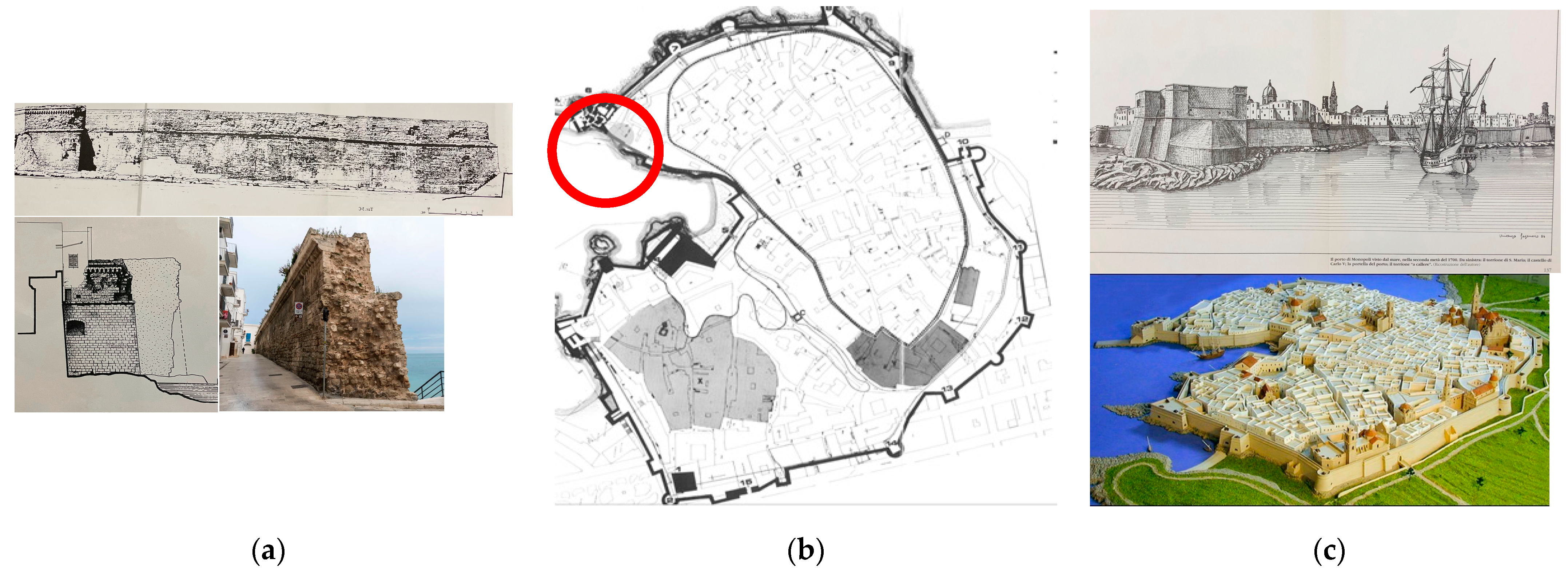
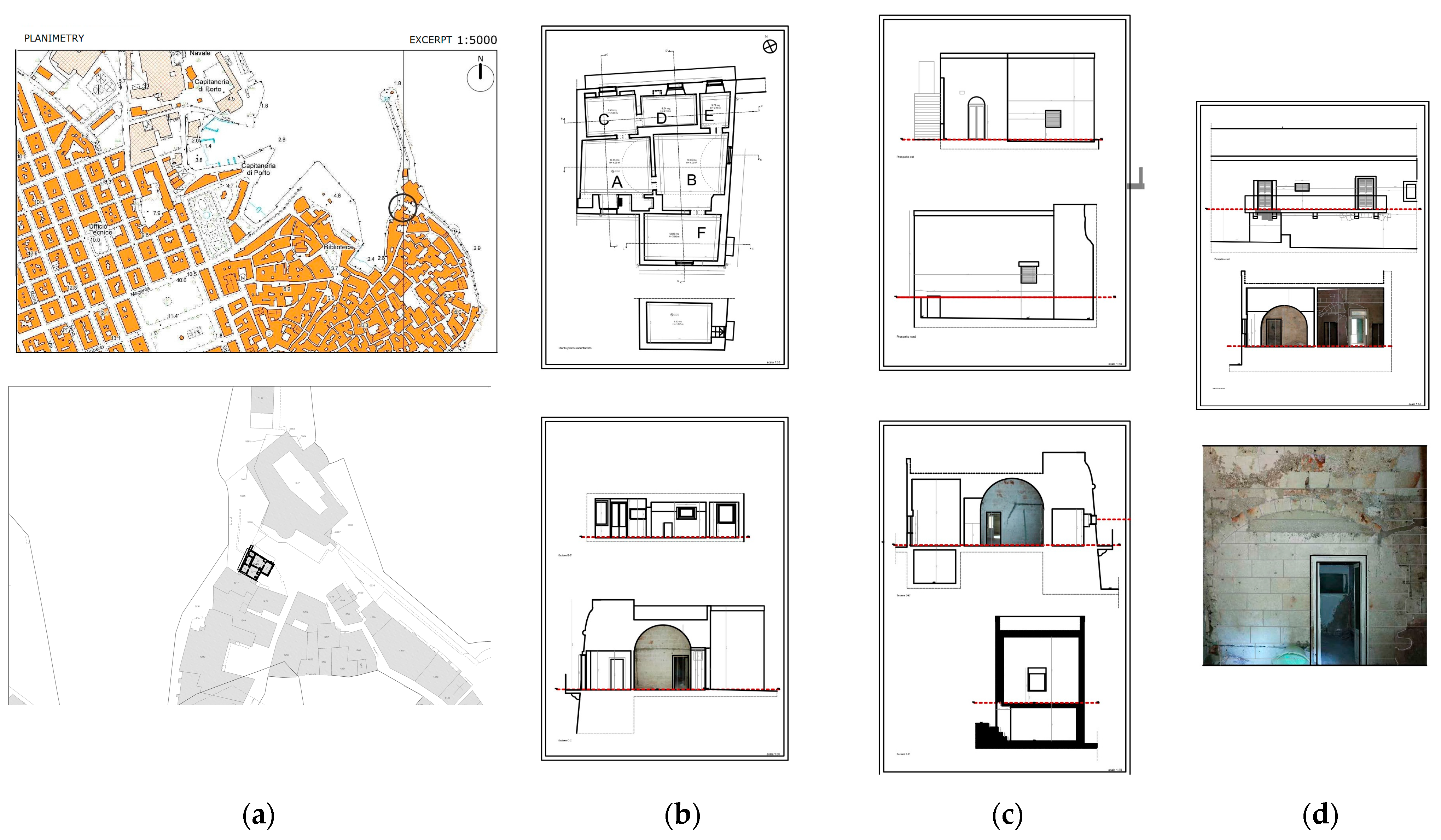
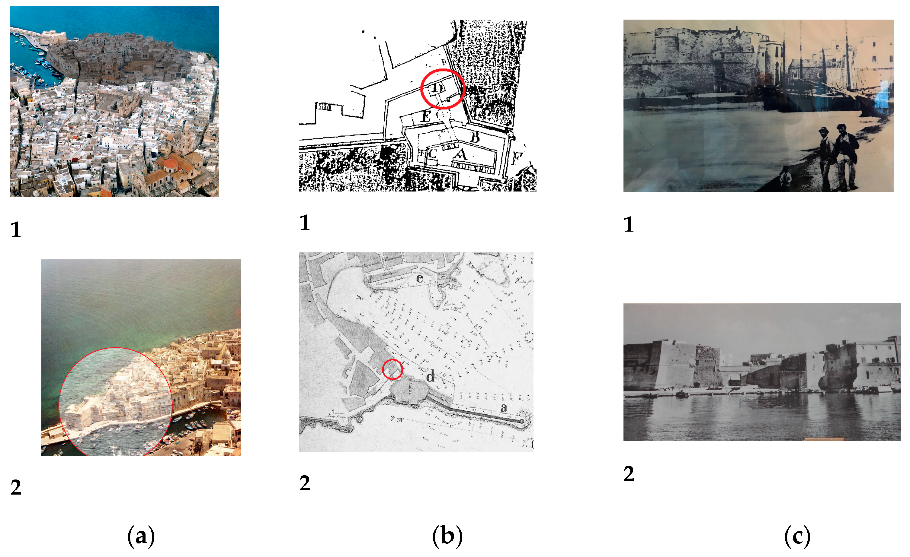
3. Surveys on the Historic Urban Landscape
4. Critical Drawings
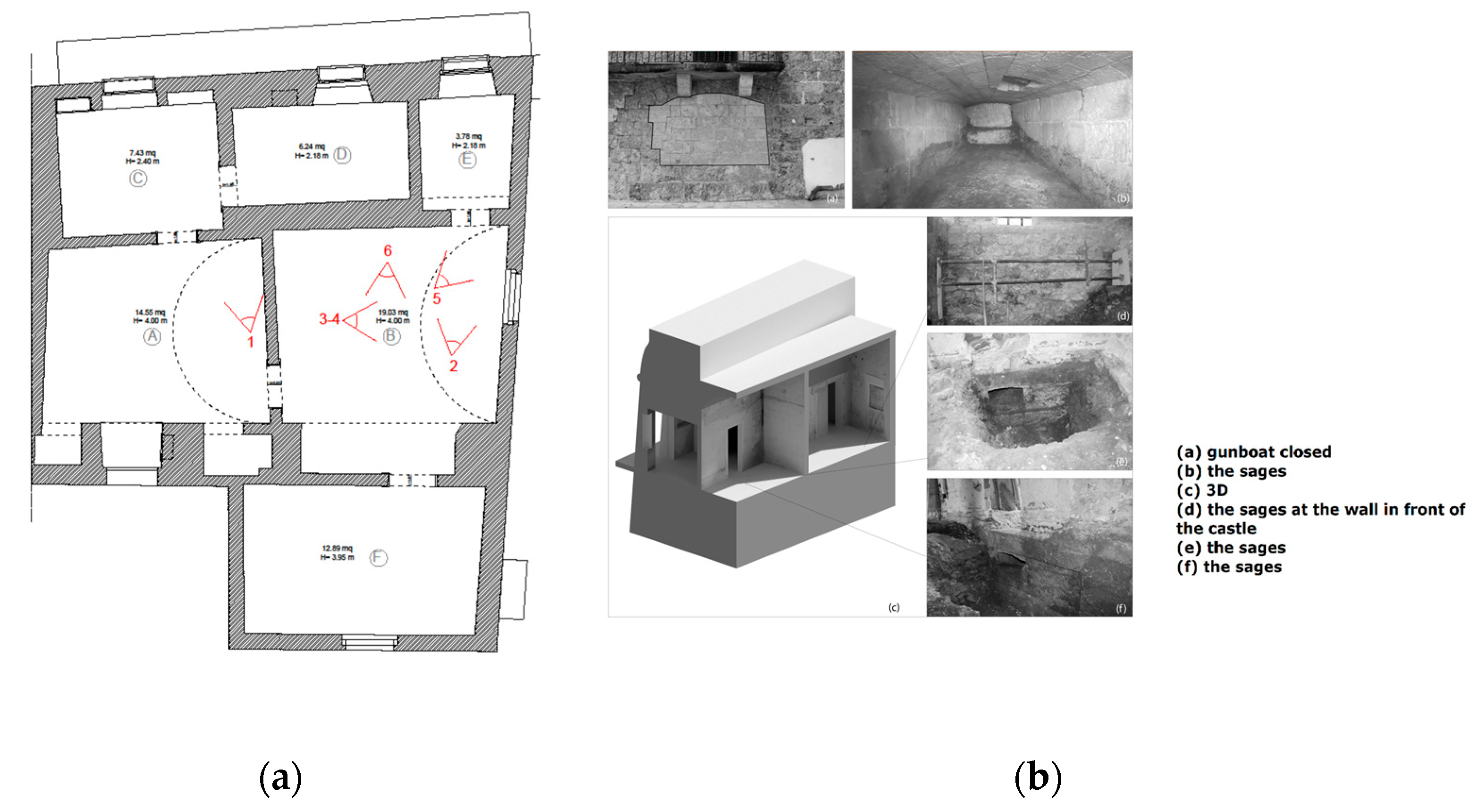
5. The Sages
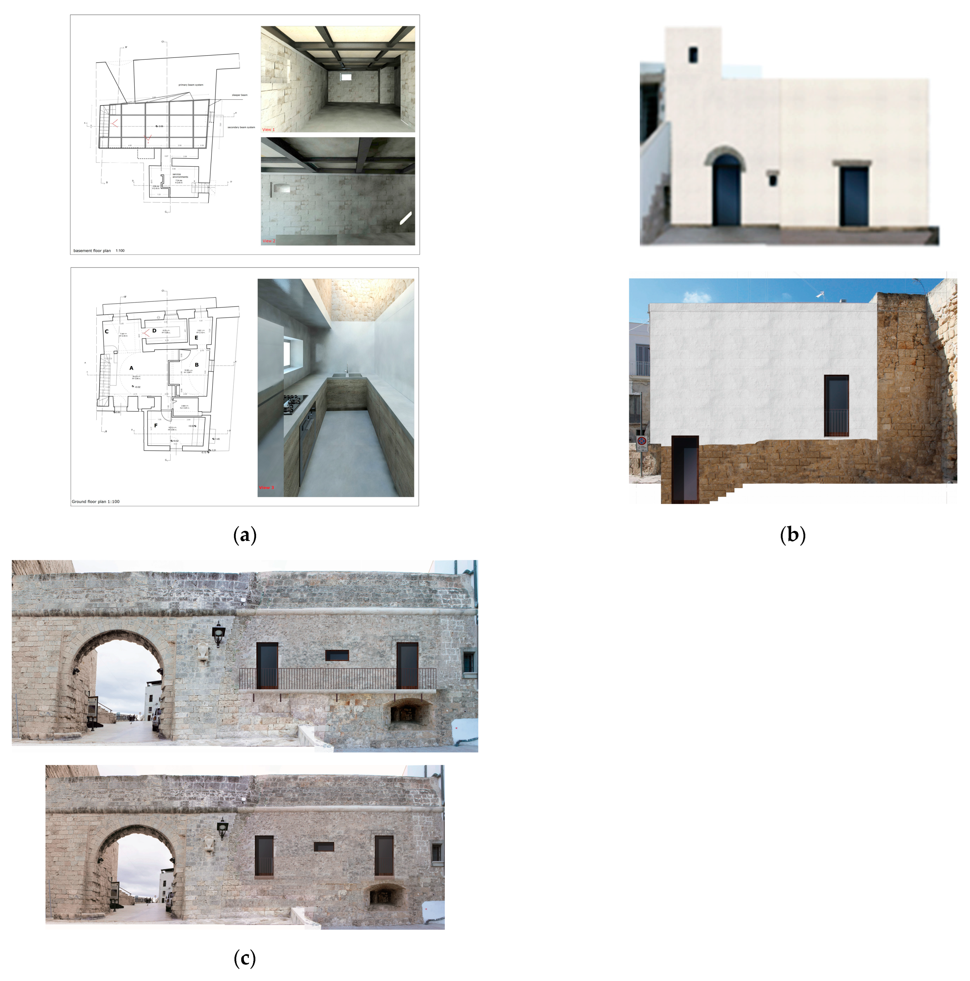
6. The Project
7. The Restoration Site
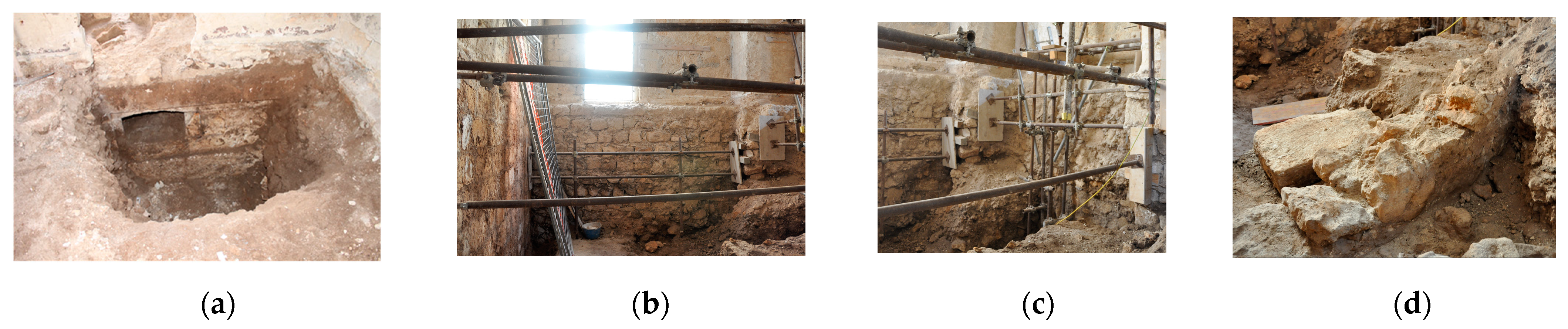
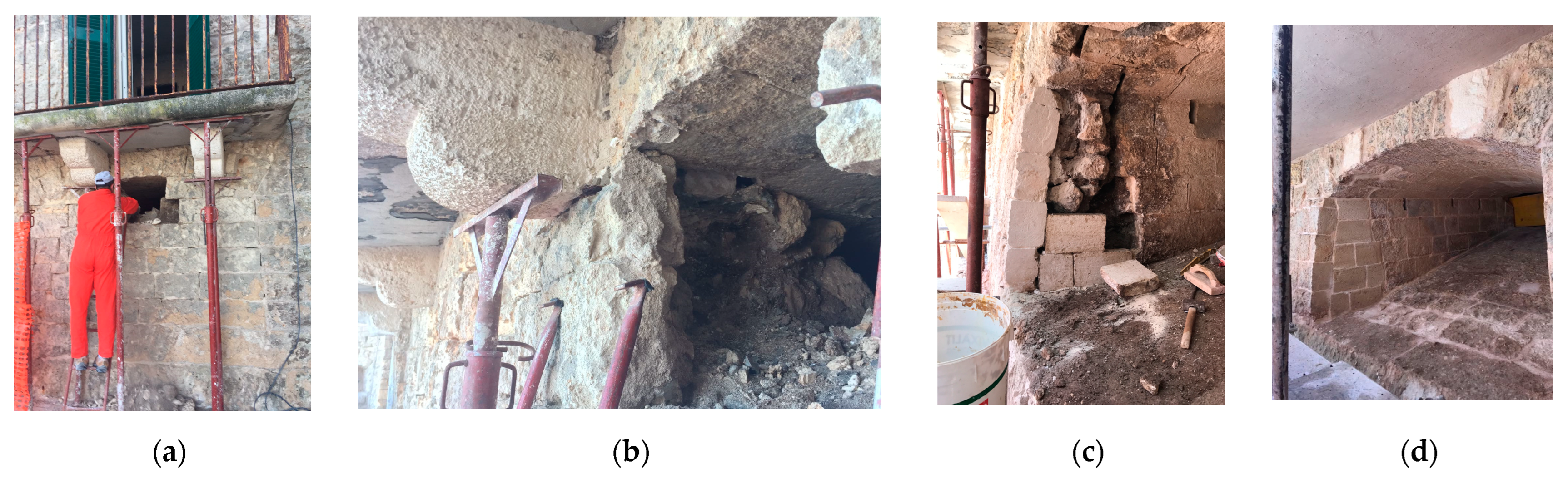
7.1. The Excavation
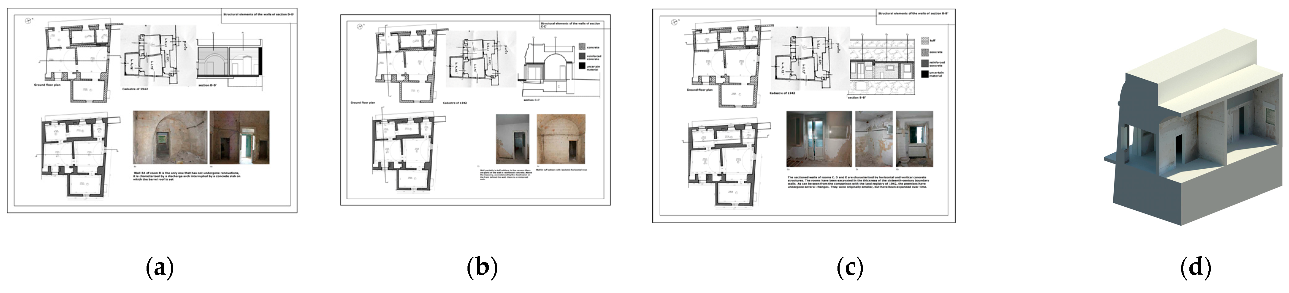
7.2. The Reconstruction of the Transformation Phases: Morpho-Typological and Stratigraphic Analysis
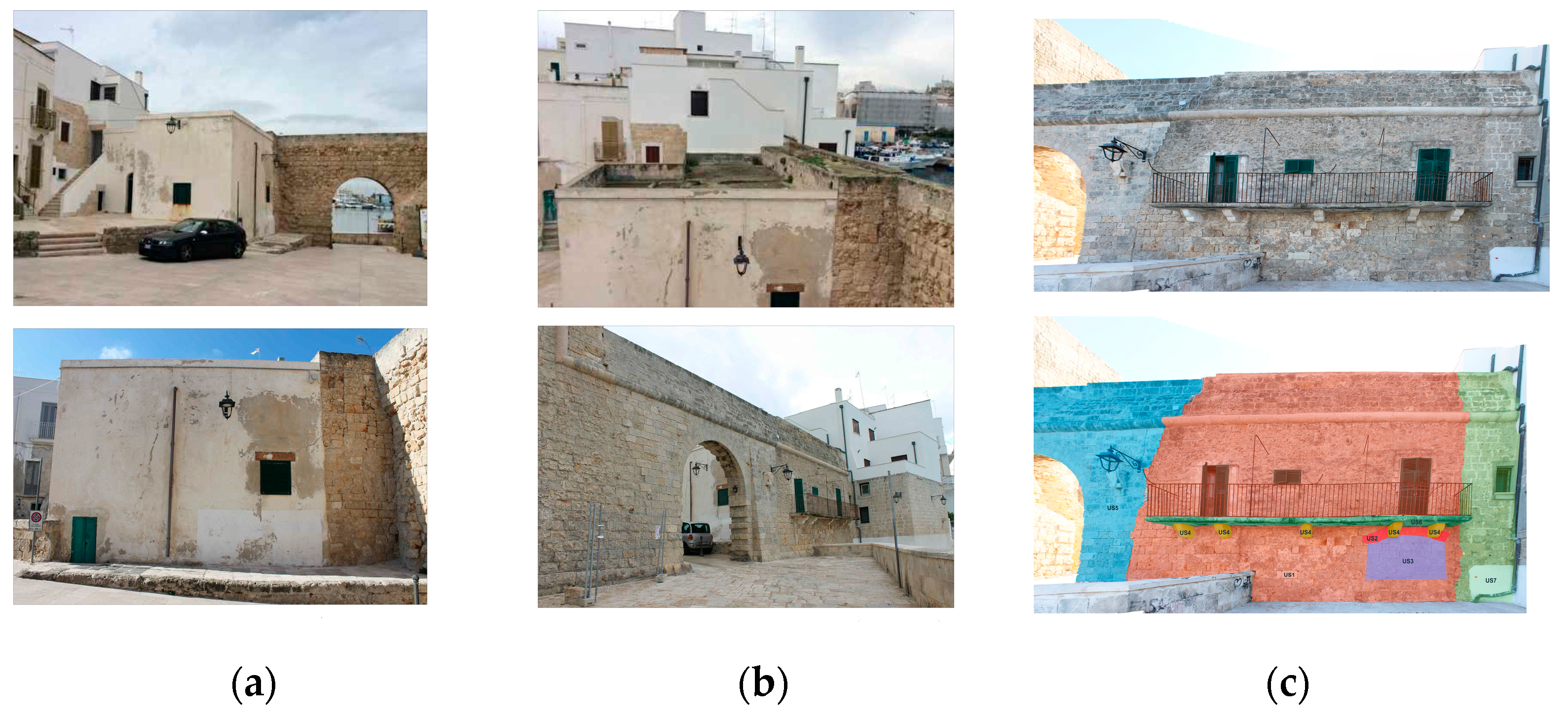
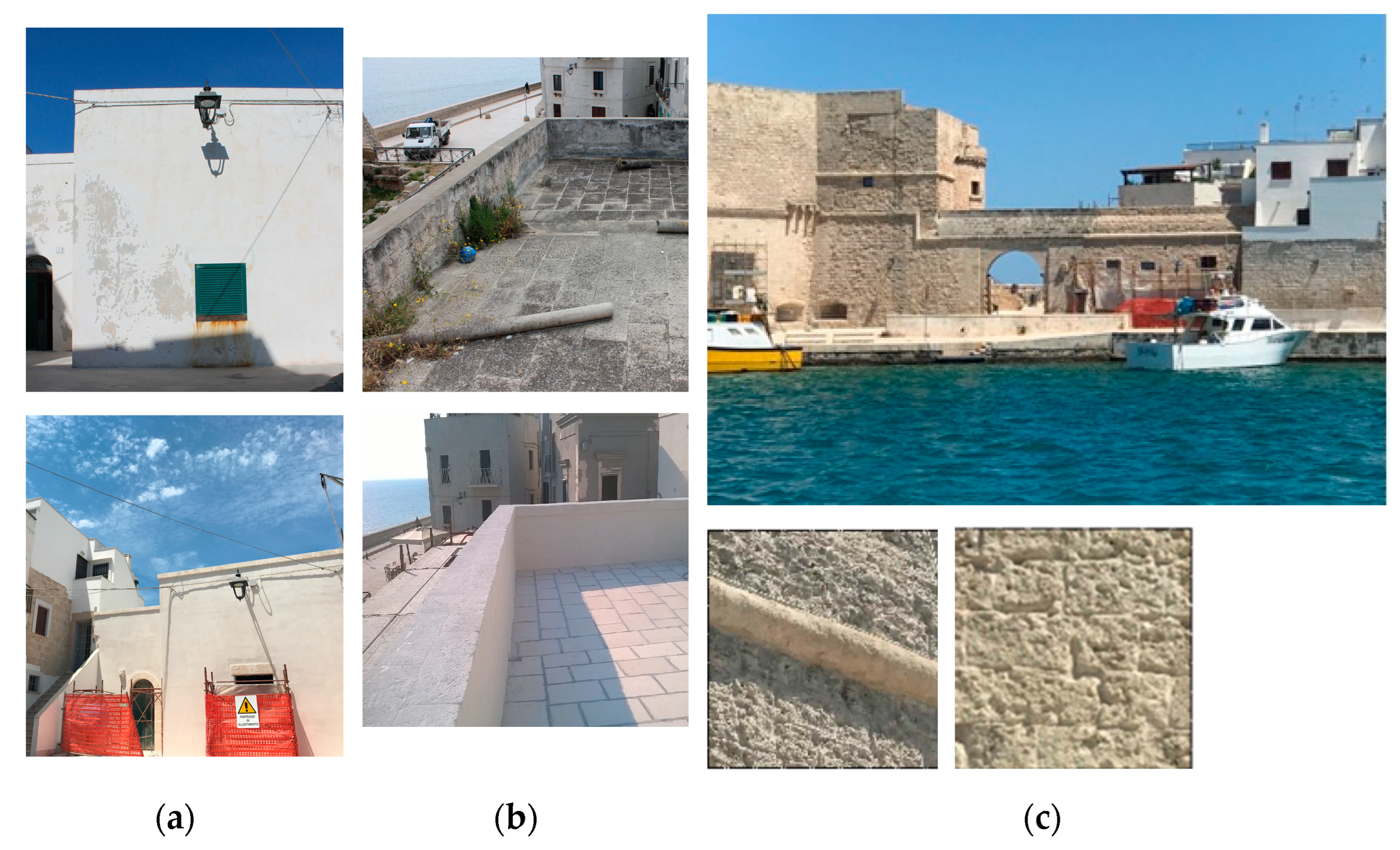
7.3. The Construction Site under the Walls
7.4. The Construction Site of the External Walls
8. Conclusions
Funding
Institutional Review Board Statement
Informed Consent Statement
Data Availability Statement
Acknowledgments
Conflicts of Interest
References
- Legislative Decree 22 January 2004, n. 42, Code of Cultural Heritage and Landscape Published in the Official Gazette of the Italian Republic No. 45 of 24 February 2004. It Entered into Force on 1 May 2004. Available online: https://leap.unep.org/countries/it/national-legislation/legislative-decree-22-january-2004-n-42-code-cultural-and (accessed on 10 December 2022).
- DettagliCategoria Principale: Beni CulturaliCategoria: DottrinaPubblicato: 30 Novembre -0001Visite: 16745. L’assenza di una Definizione Legislativa di “Centro Storico”. Ruggiero Marzocca. Available online: https://lexambiente.it/materie/beni-culturali/171-dottrina171/1774-Beni%20culturali.%20Centri%20storici.html (accessed on 10 December 2022).
- Pane, R. Historical Center and Ancient Center in AA.VV; The Ancient Center of Naples: Naples, Italy, 1971; Volume I, p. 15. [Google Scholar]
- Diceglie, A. The cathedrals on the sea of Puglia. In Proceedings of the International Congress VIII Centenary Cathedral of Burgos, “El mundo de las Catedrales”, Burgos, Spain, 13–16 June 2022; pp. 493–499. [Google Scholar]
- Carocci, C.; Macca, V. Buildings’ Masonry Work: Construction Quality and Seismic Damage after 2016 Italy Earthquake. In Proceedings of the HERITAGE 2020—7th International Conference on Heritage and Sustainable, Development, Coimbra, Portugal, 8–10 July 2020; pp. 481–490. [Google Scholar]
- Capalbo, A. Finalborgo, Housing Phenomena in the Transformation of City Walls. Master’s Thesis, Architecture for the Restoration and Enhancement of Heritage, Polytechnic University of Milan, Milan, Italy, 2020. [Google Scholar]
- Diceglie, A. Conservation problems of archaeological structures subject to humidity variations. The Case Study of the castle of Santo Stefano. In Proceedings of the First International Scientific Conference “The Colors of Restoration”, Nardini Editore, Catania, Italia, 18–19 October 2021; pp. 475–489, in press. [Google Scholar]
- Diceglie, A. The Castle of Santo Stefano in Monopoli in Puglia; Archeology for Architecture, Gangemi: Rome, Italy, 2018; pp. 9–11. [Google Scholar]
- Carrieri, M. Monopoli (Bari), Church of San Pietro. In Taras; Scorpione Ed.: Taranto, Italy, 1989; pp. 254–255. [Google Scholar]
- Capitanio, D. The defensive system and the city. In Monopoli in Its Past; Prospero Rendella Municipal Library: Monopoli, Italy, 1991; Volume 5, pp. 11–84. [Google Scholar]
- Cinquepalmi, A. Historic Center (Monopoli, Bari), in Documents from the Bronze Age, Investigations along the Apulian Adriatic Side; Ministry of Cultural and Environmental Heritage, Archaeological Superintendency of Puglia, National Museum of Egnazia: Fasano, Italy, 1998; pp. 101–103. [Google Scholar]
- Carrieri, M. Monopoli (Bari), Duomo. In Taras; Scorpione Ed.: Taranto, Italy, 1987; pp. 175–177, (in particular p. 176). [Google Scholar]
- Barletta, M.; Papio, A.; Rotondo, S. Historical-Critical Contribution to a Systematic Study on the Transformations of the Castle of Monopoli, Extract from Monopoli in Its Past; N.5; Prospero Rendella Municipal Library: Monopoli, Italy, 1991. [Google Scholar]
- Lillo, S.A.C.M. Municipal Archive of Monopoli, File 673, Category X, Public Works: Map a part of the Municipality of Monopoli with an indication of the works proposed for the formation of the port (Ing. Lamberti, 1866). In Monopoli Sintesi Storico Geografica; Officine Grafiche Colucci: Monopoli, Italy, 1976. [Google Scholar]
- Stima della Vulnerabilità Sismica dei Centri Urbani: Il Caso di Forlì. Available online: https://www.ingenio-web.it/articoli/stima-della-vulnerabilita-sismica-dei-centri-urbani-il-caso-di-forli/ (accessed on 15 November 2022).
- Diceglie, A.; D’Amico, N. The restoration site of a house in Monopoli, Largo Castello, N. 5. In Proceedings of the 3rd International Conference on Conservation, Maintenance and Rehab, Braga, Portugal, 14–16 June 2017; June, Barcelos: Green Lines Instituto para o Desenvolvimento Sustentável/Green Lines Institute for Sustainable Development: Barcelos, Portugal, 2017; pp. 223–231. [Google Scholar]
- Italian Alliance for Sustainable Development Born in 2016 in Order to Increase the Importance of the 2023 Agenda. Available online: https://asvis.it/asvis-italian-alliance-for-sustainable-development (accessed on 10 December 2022).


Disclaimer/Publisher’s Note: The statements, opinions and data contained in all publications are solely those of the individual author(s) and contributor(s) and not of MDPI and/or the editor(s). MDPI and/or the editor(s) disclaim responsibility for any injury to people or property resulting from any ideas, methods, instructions or products referred to in the content. |
© 2023 by the author. Licensee MDPI, Basel, Switzerland. This article is an open access article distributed under the terms and conditions of the Creative Commons Attribution (CC BY) license (https://creativecommons.org/licenses/by/4.0/).
Share and Cite
Diceglie, A. Restoration of the City Walls of Monopoli in Puglia (Italy)—The 16th Century House within the Walls: From the Discovery of the Gunboat to the Recovery of the Basement. Sustainability 2023, 15, 2300. https://doi.org/10.3390/su15032300
Diceglie A. Restoration of the City Walls of Monopoli in Puglia (Italy)—The 16th Century House within the Walls: From the Discovery of the Gunboat to the Recovery of the Basement. Sustainability. 2023; 15(3):2300. https://doi.org/10.3390/su15032300
Chicago/Turabian StyleDiceglie, Angela. 2023. "Restoration of the City Walls of Monopoli in Puglia (Italy)—The 16th Century House within the Walls: From the Discovery of the Gunboat to the Recovery of the Basement" Sustainability 15, no. 3: 2300. https://doi.org/10.3390/su15032300
APA StyleDiceglie, A. (2023). Restoration of the City Walls of Monopoli in Puglia (Italy)—The 16th Century House within the Walls: From the Discovery of the Gunboat to the Recovery of the Basement. Sustainability, 15(3), 2300. https://doi.org/10.3390/su15032300