Abstract
This article discusses the processes of moisture intake, redistribution, and consumption within the downy oak forest community, along with their interannual and interseasonal water balance dynamics. The study of the water balance components was conducted using a combination of field research methods and geoinformation modeling on the territory of the Karadag landscape and ecological station of the Karadag Nature Reserve for the period from 2010 to 2020. The study of the water balance of downy oak forests located at the furthest extent of their range represents an important problem, whose solution will further scientific understanding by uncovering individual patterns of the internal organization of such systems. The indicators having the most tangible impact on the water balance are the amount of precipitation and evapotranspiration. The average annual precipitation on the territory of Karadag for the analyzed period was 448 mm; in recent years, a decrease in the amount of precipitation has been recorded. The evapotranspiration values within the downy oak forests approximately coincide with the values of this indicator in the Mediterranean region to average 450 mm per year. The influence of stemflow and relief features on the redistribution of moisture within the landscape is described. The analyzed water balance components’ dynamics form conditions conducive to the displacement of steppe communities by forest species.
1. Introduction
The study of the Mediterranean climate and the features of its radiation, heat, and water balance are highly topical issues [1,2,3,4,5], since this region is located on the border of an arid climate and a temperate and rainy climate [6]. The theoretical foundations for studying the water balance of the territory of the Crimean Peninsula are laid out in the works of [7,8,9,10,11,12,13]. An example of evaluating the regional and local water balance characteristics in Crimea can be found in the works of [9,14,15,16,17]. At the same time, very little attention has been paid to the water balance of certain types of plant communities growing at the local level on the territory of the Crimean Peninsula.
Despite the Crimean Peninsula being located far beyond the Mediterranean Basin, the southern coast of Crimea, along with other regions of the Caucasus, is defined as an exclave of Mediterranean vegetation [18,19,20].
On the territory of the Crimean Peninsula, subtropical forest landscapes are mainly represented by downy oak and juniper formations with an admixture of Christ’s thorn, smoke tree, and Oriental hornbeam. These are represented from the coast to an altitude of 300–350 m [9], where they are either replaced by typical downy oak forests and their derivatives with an admixture of hornbeam, higher rock-oak forests with an admixture of hornbeam and ash forests, or rise to the edge of the steep southern limestone slope of the yayla (upland pasture). These communities are typically represented by shiblyak thickets, comprising a dense low-growing closed forest area, or, conversely, sparse woodlands. The Crimean shiblyak and phrygana biomes are often identified with the Mediterranean maquis and garrigues, respectively, although they differ in some important respects [14]. In contrast to the predominantly sclerophyllous maquis, deciduous species predominate in shiblyak biomes [20]. These forests formed at the furthest extent of their range due to the effect of the subtropical climate, which occurs here due to the circulatory position of the Southern coast of Crimea. Cold air masses from the north tend not to penetrate here, while those from the southern and southwestern directions linger on the south-facing slopes of the Main Ridge. At the same time, Southeastern Crimea is located in the circulatory and insolation shadow formed by the Main Ridge of the Crimean Mountains, which determines the region’s high aridity and decreased radiation balance values. Thus, the sub-Mediterranean (or semi-subtropical) climate formed on the territory of the Southeastern Crimea is characterized by warm winters, maximum precipitation during the cold period of the year (late autumn-winter), and hot, mostly dry summers.
In this regard, the study of the water balance of downy oak forests located at the furthest extent of their range represents an important problem, whose solution will further scientific understanding by uncovering individual patterns of the internal organization of such systems. Despite the relatively small areas that they cover, the importance of studying the water balance of downy oak forests in Southeastern Crimea is also due to the ecosystem functions that these forests perform (preservation of moisture reserves in the soil, prevention of negative physical and geographical processes on the slopes, etc.).
The aim of this work is to study the temporal variability and identify trends in the components of the water balance of the sub-Mediterranean downy oak landscapes of the Southeastern Crimea on the example of the Karadag landscape and ecological station. The strong suit of this study is that almost all data are obtained from long-term stationary studies. To achieve this goal, the following tasks were solved: we described in detail the conditions of the forest formation with regard to the influence of landscape components on the water balance of the territory; we revealed the dynamics of water balance components of sub-Mediterranean downy oak landscapes.
Identification of dynamics features and formation of water balance components on the basis of long-term stationary observations, and not only by means of modeling, makes it possible to more accurately identify dependencies and patterns in climate change for Mediterranean territories vulnerable to external changes in environmental conditions in the future.
2. Study Area
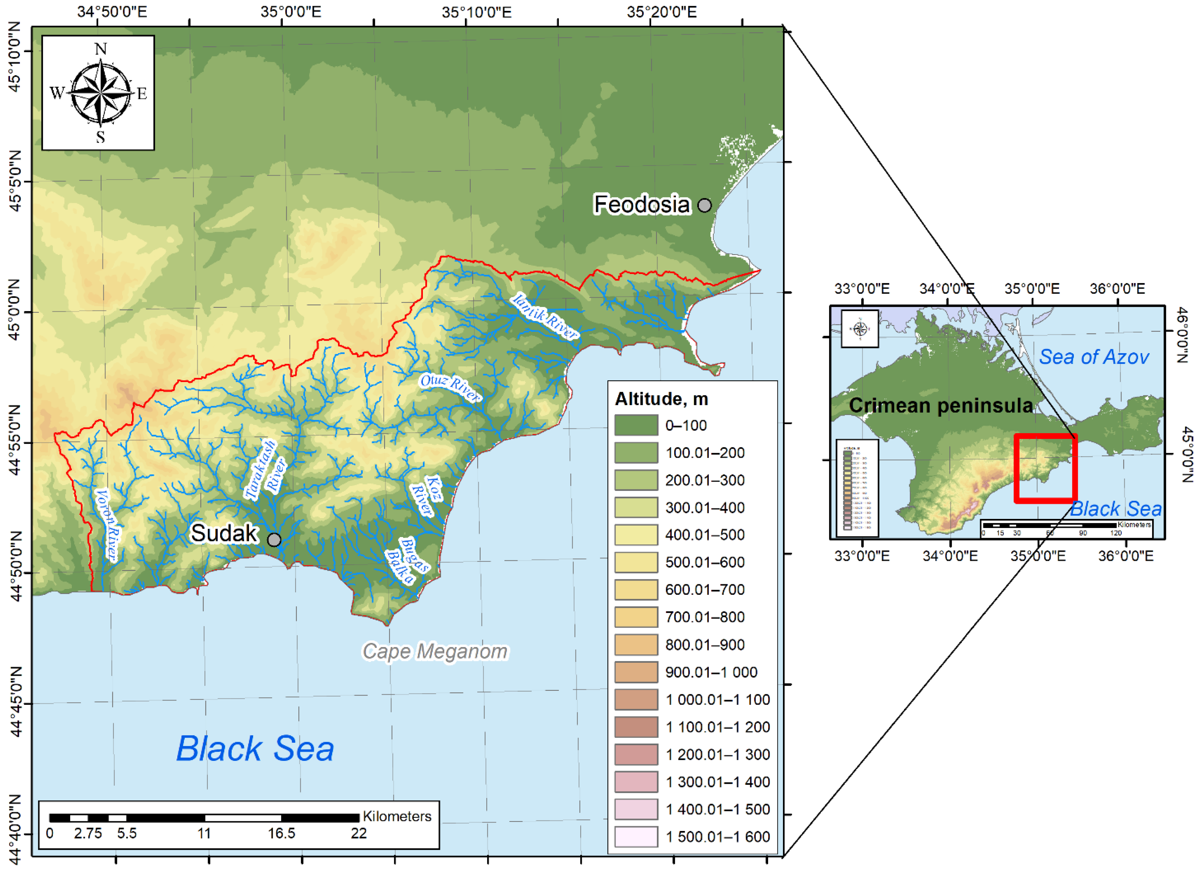
The area of study encompasses the southeastern part of the Crimean Peninsula. The concept of “South-Eastern Crimea” is often encountered in scientific publications. However, no clear boundaries of this region have yet been defined. The analysis of publications shows that the authors most often refer to the South-Eastern Crimea as the territory comprising the municipalities of Sudak and Feodosia. However, this designation is associated not with administrative units, but rather with landscape features. The natural boundaries of the studied area take the form of watersheds. The western border of the district runs along the Goller Ridge watershed between the Raven and Shelen Rivers, including the peaks of Piyakya, Biyuk-Krizh, and Livaz-Kaya. The northern border runs along the main watershed that delimits the basins of rivers flowing into the Black Sea (i.e., in a southerly direction) and the Sea of Azov (in a northerly direction). The northern border runs along the cliffs of Yuvan-Kaya, the Khambal ridge, the peaks of Kukushlu-Oba, Kazas-Olan and Apaly, Tuar-Alan Ridge, and Jady-Kaya Mountain. The northeastern and eastern borders run along the line from Kara-Oba along the Uzun-Syrt and Tepe-Oba ridges to end in the area of Cape Ilya.
The relief of Southeastern Crimea, which is represented by mountain ranges in the central and western parts, is gradually transformed into a plain towards the east. The elevation of the area varies from 0 to 917 m (Figure 1). Forest communities are mainly represented in the most elevated western and central parts of Southeastern Crimea.
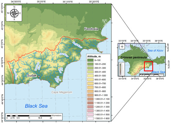
Figure 1.
Territory of Southeastern Crimea.
The distribution of plant communities throughout the region is influenced by its geomorphological structure. Steppe communities within Southeastern Crimea can be described as occupying the lowest areas (average elevation—about 100 m); these are replaced by oak shiblyaks with an average elevation of 230 m, then downy oak forests (average elevation—285 m), rock-oak forests (average elevation—340 m) and hornbeam-beech forests (average elevation—470 m). Within the area under consideration, territories with minimal terrain dissection are covered by steppe, psammophytic, and halophytic communities, while territories with the greatest relief dissection are covered by forest communities.
The slopes of Southeastern Crimea are subject to various erosion processes, including ravine formation, which determines the redistribution of forests along the slopes. Snow catchments play an important role in the spatial differentiation of forests. The linear erosion Stream Power Index (SPI) calculated for the Southeastern Crimea shows that most of the area is susceptible to strong erosion processes.
The territory of the Southeastern Crimea is characterized by Mediterranean climatic features. The average annual air temperature within the Southeastern Crimea area, which varies from the northwest to the southeast, ranges from +9° to +13°. Southeastern Crimea experiences between 100 and 300 mm of precipitation during the winter period. The precipitation field decreases from west to east (Figure 2a), with the greatest amount falling in the northwestern part of the study area. In summer, 80 to 160 mm of precipitation falls over the territory of the Southeastern Crimea, with the precipitation field decreasing from the northwest to the southeast (Figure 2b). Both in winter and in summer, the coastal areas of Southeastern Crimea are the most arid. The annual distribution of precipitation varies from 700 to 350 mm in the west-to-east and northwest-to-northeast directions.
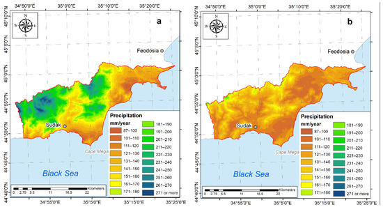
Figure 2.
Average precipitation on the territory of Southeastern Crimea for the winter (a) and summer (b) periods.
The formation of vegetation cover is affected by the distribution fields of climatic factors. Both the greatest amount of precipitation and lowest temperatures prevail in the most elevated areas of Southeastern Crimea; it is here that hornbeam and beech forests are mainly developed. Along with a decrease in the amount of precipitation, woody vegetation is gradually replaced by shrub and steppe communities. Among other formations, oak shiblyaks and tipchak steppes are characteristic of the areas where the least amount of precipitation will fall.
The density of the river network within Southeastern Crimea decreases from the southwest to the northeast from 0.3 to 0.1 km/km2 [21]. This indicator is indirectly associated with increased climate aridity and decreased precipitation. The watercourses of Southeastern Crimea fully belong to the rivers of the southern macro-slope of the Crimean Mountains. Nevertheless, the river network of Southeastern Crimea is quite complex; in general, the area is characterized by a combination of river valleys, interfluves, and watersheds (Figure 1).
Conditions for the existence of separate small catchments of small gullies and other erosive forms on the coast of Southeastern Crimea are due to the complex rugged terrain, which creates unique topological conditions for the existence of plant communities. For example, local factors disrupt the manifestation of quasi-zonal processes within the valleys of the watercourses of Southeastern Crimea. In addition to oak communities, alder, poplar, and willow are also found throughout the area.
Southeastern Crimea is characterized by a predominance of brown soils (up to 80% of the total area) [22]. Mainly weak and underdeveloped soils are formed on the destruction products of limestones, sandstones, and conglomerates composing individual mountain massifs and ridges, as well as on volcanic rocks of the Karadag massif. In the lower parts of the slopes and at their feet, full-profile and drift soil types are formed. Alluvial (17%) and meadow (2.5%) soil types are commonly encountered in the valleys. Brown mountain–forest soils within the study area have an extremely scanty distribution (about 0.3%).
In certain areas of Southeastern Crimea, vegetation cover has undergone a fundamental transformation. Here, the vegetation is represented either by agricultural crops, or goes through stages of degradation and restoration, which in turn directly affects the water balance of the area due to the capacity of vegetation to retain and redistribute moisture. The vegetation and soil cover, along with the water balance of soils, are additionally affected by the widespread rooting activity of wild boar, which leads to desiccation of the soil and increased evaporation from its surface [23].
3. Materials and Methods
In the classical form, the water balance equation [24] can be represented in the following form (Figure 3):
where x is precipitation on the surface of the object; y1 is surface inflow of water from outside; w1 is underground inflow of water from outside; z1 is condensation of water vapor; y2 is surface outflow of water outside the object; w2 is underground outflow of water outside; z2 is evaporation; Δu is change in the volume of water within the object (contour).
x + yl + wl + z1 = y2 + w2 + z2 ± Δu,
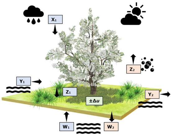
Figure 3.
Scheme of the water balance equation. Black arrows show the flows direction.
At the local level of the study, the structure of the water balance becomes an even more complex phenomenon. The structure of the water balance of forests comprises several elements: the flow of water with precipitation and surface runoff from neighboring areas, canopy interception, stem flow, transpiration and evaporation from tree crowns, water flow to the forest litter surface, evaporation from the forest litter surface, infiltration, evaporation of water from the soil, its retention by precipitation (formation of soil moisture capacity and precipitation), surface runoff, subsurface runoff, and water transfer to groundwater runoff.
The study of the water balance components of downy oak forests was conducted under the auspices of the Karadag Landscape and Ecological Station (KLES) of the Karadag Nature Reserve. The KLES is located in the redivision of the major catchment gully (0.6 km long, 17 ha area) on the eastern slope of the Besh-Tash ridge, 1.5 km from the village of Kurortnoe. There, the precipitation and soil moisture parameters are measured in a meteorological site located in an open area in the lower part of the catchment. A precipitation collector and soil lysimeters are also installed in the middle part of the catchment area under the canopy of the forest. Observations of soil moisture are carried out at 30 points located in areas with forest, shrub, and steppe vegetation. Monitoring of the runoff is carried out on two runoff sites located within the KLES area. Figure 4 shows the network of monitoring stations.
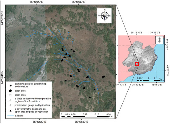
Figure 4.
Area covered by the Karadag Landscape and Ecological Station (KLES) and monitoring points.
The KLES area is representative of the entire Karadag Nature Reserve, since almost all types of plant communities are represented here. The vegetation cover is characterized by a strong mosaicism, which is due, among other things, to the relief dissection. More than 20% of the KLES area is occupied by forest communities. They are mainly represented by a downy oak formation (Querceta pubescentis) with the addition of Acereta campestrii, Pistacieta muticae, and Pineta pallasianae. Shrub communities, which occupy about a tenth of the study center area, are represented by formations of thorny shrubs—Paliureta spinae-christi, Rosaeteta corymbiferae, Pruneta spinosae, and Rubeta taurici. Herbaceous communities are quite diverse and occupy more than 60% of the hospital territory [9].
In order to obtain values for building evapotranspiration maps, data from the open database of the ERA5 reanalysis of the Copernicus Climate Change Service project [25], implemented by the European Center for Medium-Range Weather Forecasts (ECMWF), were used. As a result, the average monthly data for 1978–2021 were obtained. The data are presented in the netCDF4 format and cover the territory in question with a regular grid with a cell size of 0.25° × 0.25°.
4. Results and Discussion
The water balance of any territory depends on climatic factors and the nature of the underlying surface. The literature provides various values of the average annual precipitation falling on the territory of the Karadag reserve. On average, 357 mm of precipitation falls on Karadag (for the period from 1930 to 1980) [26]; according to other data, 389 mm of precipitation (for the period from 1920 to 2006) [27], 501 mm of precipitation (for the period from 2000 to 2011), and 467 mm of precipitation (for the period from 2012 to 2018) according to [28].
According to our observations, an average of 448 mm of precipitation fell annually on the territory of Karadag from 2010 to 2020. This is significantly less than in a typical Mediterranean region. Due to the presence of downy oak forests in Northeastern Crimea, environmental conditions can be considered as transitional from optimal to pessimal. For example, within the limits of downy oak forests growing about 15 km north of Montpellier in southern France at an altitude of 250 m, the average annual precipitation is 1311 mm [29]. In Italy, downy oak forests receive about 850 mm of precipitation; in the area of the city of Evora in Portugal, the corresponding figure is 665 mm [30].
In terms of the interannual quantitative dynamics of incoming precipitation, a wide range of values is observed: in 2020, an average of 275 mm of precipitation fell on Karadag, while in 2010, the corresponding amount was 715 mm. Thus, the amplitude reaches 440 mm of precipitation. In 2010–2020, there is a tendency towards a reduction in the amount of precipitation: 2019 and 2020 are both characterized by extremely low average annual precipitation values.
In the intra-annual dynamics, a constant winter maximum of precipitation is observed within the downy oak forests. However, in some years (2013, 2014), absolute precipitation maxima were observed in the study area in June (45% of the annual precipitation), which were catastrophic for the environment. July and August are characterized by stable arid conditions, with an average of 31 mm precipitation. The winter maximum is characterized by a predominance or uniform distribution of precipitation during the late autumn and winter months. The average amount of precipitation in December is 45 mm; in January, 48 mm; in February, 33 mm. Spring and autumn precipitation minima are characterized by a decrease in the amount of precipitation: on average, 27 mm of precipitation falls in spring within the downy oak forests, while in autumn, average precipitation is 34 mm.
In downy oak communities, retention of precipitation in crowns is around 24% of precipitation, comprising an average of 104 mm. Considering their relatively small amount of precipitation, the forest communities of Karadag can retain up to 100% of precipitation [28]. At the same time, there is an intra-annual dynamic to this process, associated both with the vegetation stages of plants and with the intensity of precipitation. Thus, the maximum values of precipitation retention by crowns are typical for the second half of spring to early summer due to plants achieving a maximum of green phytomass during this period. For example, in July, an average of 9 mm (about 41%) of precipitation of precipitation is retained. The retention of precipitation by tree crowns is also affected by the precipitation intensity. In [28] it is indicated that up to 20% of precipitation is retained when more than 20 mm precipitation falls on Karadag, while when precipitation is less than 2 mm, over 45% is retained. Data analysis shows that the increase in precipitation observed in Southeastern Crimea is formed due to summer heavy rainfalls [16]; this in turn leads to most of the water penetrating under the canopy of the forest, with little retention in the crown. In addition, large drops characteristic of heavy rainfall are poorly retained on the leaves, quickly draining to the surface of the forest floor.
A significant role in the water balance structure of downy oak forests is played by stem flow. This effect is interesting due to its concentration of water flow directly under the roots of trees. However, under conditions of sloping terrain, this process can intensify sheet-, drip-, and fine-jet erosion of soils, exposing the roots of trees and accelerating the processes of badland formation. In [9], a methodology for assessing stem runoff in the territory of Karadag is given; however, quantitative characteristics of the experimental results are lacking. A.A. Klyukin in [31] notes that in an oak forest with a canopy density of 0.8, growing on a slope with a steepness of 20–25° and a length of 100 m, the average accumulation of erosion near tree trunk is about 0.004 mm/year. At the same time, A.A. Klyukin notes that the average rate of erosion can reach 2.0–3.9 mm/year on steep and short slopes that are adjacent to river valley beds and talvegs of temporary watercourses, accompanied by exposure of the parent rock. Thus, such processes are characteristic of steep slopes. On slopes of medium and low steepness, such processes are not significantly manifested, with the retentiveness of the soil being provided by an herbaceous layer. A.A. Klyukin in [31] notes that the trunks of an adult oak can run off 5–6 L of precipitation per year; in our opinion, this figure is significantly overestimated for the forests under study. The more objective data in [7] indicate that runoff from oak trunks reaches 3%–5% of the annual precipitation layer, which is equivalent to approximately 20–40 mm/year. Stem runoff is also actively affected by the roughness of the bark of tree trunks, which demonstrates that the real area of the runoff is larger than the ideal cylindrical shape of the trunk. In oak forests, this indicator, according to [9], reaches 1.2, allowing them to be attributed to medium rough type. By comparison, stem runoff in oak forests in Spain accounts for slightly more than 10% of precipitation [32].
According to measured data on sample trees, throughfall accounts for about 75% of the total precipitation amount. Comparable results were obtained by V.A. Bokov’s expeditions in this area in 1997 and 1998. [9]. According to his research, a dense downy oak forest intercepts about 25%–35% of precipitation during the growing season from May to October, which is about 103 mm in a wet summer (1997) and 55 mm in a dry one (1998). However, this moisture, which enters the soil surface more gradually than heavy rainfall, is generally well-retained by the forest floor, helping to form its moisture reserve. This corresponds to around 28 and 35%, respectively, of the precipitation depth that fell during the growing season, or 18 and 16% of the annual precipitation layer. During winter, when vegetation is absent in deciduous forests and there is no foliage on the trees, precipitation almost completely penetrates under the canopy of the forest, only being slightly delayed by tree branches. According to the results of measurements carried out in the winter season, precipitation retention of slightly more than 20% does not exceed the annual average. However, given that the winter months account for the maximum precipitation and taking into account the seepage through the crowns, this indicator is much higher than the summer maximum and accounts for no more than 15 mm of precipitation. These data are partially confirmed in the work [14], where it is indicated that during the period from 2000 to 2008, 162 mm was retained within the downy oak forests of Southeastern Crimea, which is approximately 30% of the amount of precipitation. At the same time, observations show that heavy rains are not so characteristic of the winter precipitation maximum, resulting in the possibility of a satisfactory soaking of the forest litter and soil. M.A. Kochkin notes [7] that the forest floor of oak forests, consisting of leaves and dead herbaceous vegetation, absorbs and retains water from precipitation, thereby reducing surface runoff.
For the period from 2010 to 2020, there has been a significant decrease in soil moisture: in average annual terms, by about 1.6 times. The inter-seasonal dynamics of decreasing soil moisture shows that almost all seasons of the year are characterized by a drop in average relative humidity values close to the average annual value, with the exception of autumn, when relative humidity decreases by 1.4 times. Considering the interannual dynamics, it is important to highlight a significant reduction in soil moisture in December (by more than 2.5 times), as well as minor reductions in September. The maximum relative values of soil moisture are experienced during the winter months, as well as in March, when the average value does not fall below 25%, while the minimum values occur at the end of summer and beginning of autumn (August and September), when the relative soil moisture values drop to 15%–18%.
During the period from 2010 to 2020, evapotranspiration within the downy oak forest community averages 450 mm. These values are generally equivalent to the evapotranspiration of oak forests in the Mediterranean region: 343 ± 37 mm in the Mediterranean region as a whole [30], 458 mm in the province of Tarragona in Spain [32], 823 mm in the eastern Pyrenees [33]. Maximum evapotranspiration values in the Mediterranean can reach 1300 mm per year [34].
Analyzing the interannual evapotranspiration dynamic within the oak forests of Karadag, its values can be seen to form a steadily increasing trend (Figure 5).

Figure 5.
Average annual values showing the relationship between evapotranspiration and precipitation in the downy oak forest in the period 2010–2020.
When considering the seasonal evapotranspiration values, the fact of the predominance of precipitation over evapotranspiration in the winter and autumn periods becomes clearly evident. During winter, the average evapotranspiration value is 11 mm, which is approximately 26% of the amount of precipitation. In autumn, the average evapotranspiration is 22 mm, which is approximately 63% of the average amount of precipitation for this time of year. In the remaining seasons of the year, there is an excess of evapotranspiration values over precipitation. In spring, the average evapotranspiration of 56 mm is 2 times higher than the average amount of precipitation for this season; in summer, the equivalent amount is 67 mm, which is 1.5 times more than the average amount of precipitation at this time of year. At the same time, a steady tendency towards increased average annual values of evapotranspiration is evident at all times of year.
When considering the distribution of evapotranspiration by month, the highest values of evapotranspiration are characteristic of May, June, and July, when the average values of evapotranspiration exceed 70 mm. The lowest values are experienced for December, January, and February, when average evapotranspiration does not exceed 15 mm. In spring, there is a gradual increase in evapotranspiration values, while in autumn there is a gradual decrease. Nevertheless, data analysis also demonstrates a significant increase in evapotranspiration occurring in recent years during late summer and early autumn.
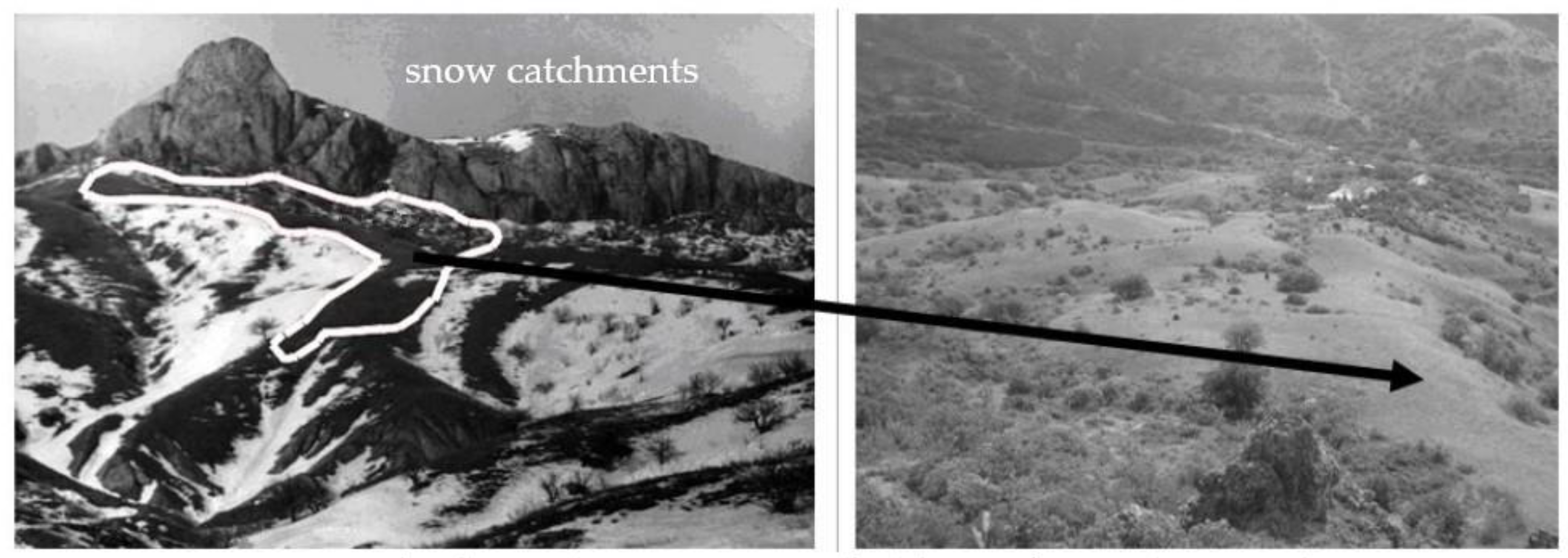
A significant role in the spatial differentiation of downy oak forests is played by accumulations of snow. Around 5% of precipitation falls in the form of snow in the Karadag area [26]. According to [9], in the Southeastern Crimea in the area of Karadag and Echkidag, between 50% to 90% of snow can be blown off the windward northeastern slopes. Although winter precipitation is generally not retained by tree crowns due to the absence of foliage, it can be carried as a result wind transport. For example, in 2019, a layer of snow with a 15 cm high was formed as a result of wind activity. For the period from 2011 to 2020, the average annual precipitation in solid form was 38 mm, accounting for approximately 9% of the total. However, in terms of the interannual dynamics of the indicators under consideration, the years with the minimum amount of solid precipitation (2013, 2020) can be distinguished, when the amount of precipitation in solid form did not exceed 10 mm, as well as the years of maximum solid precipitation—for example, 2015 and 2016—when the corresponding amount was more than 60 mm. Despite the duration of snow in Southeastern Crimea lasting no more than a week, the phenomenon of snow catchments is very characteristic; where the accumulated snow is blown onto the slopes of the southern exposures, more hydrophilic conditions are formed on these slopes than those with northern exposures. For example, within one of the gullies on the eastern slope of the Besh-Tash Range, the slope of the southern exposure is characterized by better moisturization than the opposite slope. This is due to the extensive snow collection adjacent to the slope of the south-southwestern exposure, from which the snow is blown by northeasterly winds to the slope of the south-southwestern exposure (Figure 6) [35]. In this regard, the slope of the south-southwestern exposure is better forested and characterized by greater erosion indentation as compared with the opposite slope of the north-northeastern exposure and slopes of the south-southwestern exposure, where areas with heavily washed soil cover are noted.
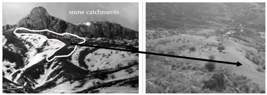
Figure 6.
Snow-covered slopes of the south-southwest exposure of the gully on the eastern slope of the Besh-Tash ridge [35].
The formation of surface runoff depends on a whole complex of factors. A slope runoff characterized by insignificant indicators is identified on the basis of observations carried out at the runoff sites. In most cases, runoff is caused either by melting snow or heavy precipitation. In 1996–1997, the average runoff was approximately 0.16 L/km2 [9]. The average value of the runoff from 2010 to 2020 recorded by the measurement results was 0.04 L/km2. The highest average runoff values, which were recorded in 2010, amount to 0.09 L/km2, while the lowest figures recorded in 2011 and 2020 were slightly less than 0.02 L/km2. Thus, these values have no significant effect on the final equation of the water balance of downy oak forests. A decrease in the values of surface runoff in the interannual dynamics is noted for the period under review.
Horizontal precipitation (condensation from fog, frost, frost, ice, etc.) plays a prominent role in the formation of the water balance of downy oak forests. Although we unfortunately did not have the opportunity to conduct real measurements of their contribution to the formation of the water balance of forests, according to the data [36], their contribution can reach 20%–25% of the annual precipitation layer. From September to March, no more than 20 days with foggy conditions can be observed within the downy oak forests; on an annual basis, the number of foggy days varies from 20 to 40 [37]. According to the Feodosiya weather station [8], there is an average of 24 foggy days per year. In 2020, 36 days with fog were recorded within the downy oak forest, of which 75% occurred during the winter period, significantly affecting the incoming part of the water balance.
All the processes described above take place against a background of the displacement of steppe communities by forest communities on the upper parts of the slopes (Figure 7). The growth of heavy rainfall in summer leads to a rapid flushing of water from the upper parts of the slopes, which are characterized by petrophytous steppe communities, along with an increase in soil moisture in the lower parts of the slopes, which creates conditions for forest communities to rise up the slope, reducing the number of slope microzones. This phenomenon is clearly visible when calculating the normalized difference vegetation index (NDVI) (Figure 7 and Figure 8). When analyzing the average NDVI values for August, which were obtained from Sentinel-2 satellite images in the period from 2016 to 2018 and from 2019 to 2021, an increase in the values can be clearly observed, along with a corresponding increase in the quantity of green phytomass. Figure 8 shows that forest vegetation increases up to 158 m on the profile AB, with the NDVI values not significantly changing from one period to the next. Conversely, above the 158 m mark, where there is initially less woody vegetation, and in August, respectively, less green phytomass, there is an increase in NDVI values and, accordingly, the amount of green phytomass.
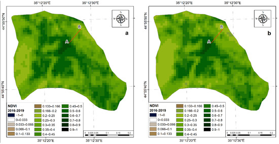
Figure 7.
Comparison of NDVI values in 2016–2018 (a) and 2019–2021 (b). AB—slope profile.
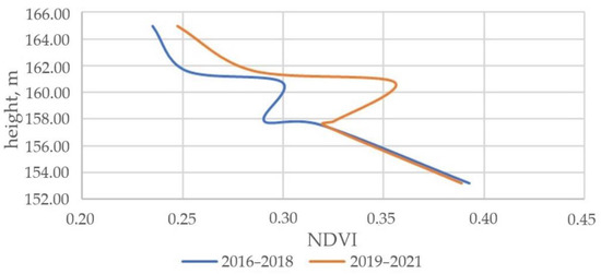
Figure 8.
Change of NDVI values for the period from 2016 to 2018 and from 2019 to 2021 from the foot of the slope to the top along profile AB.
5. Conclusions
When studying the forests water balance, it is extremely important to describe in detail the conditions its formation: geological structure, relief, hydrological features of the territory. It is necessary to give a description, characterizing their influence on the spatial differentiation of forests. So, summarizing the above, the slopes of the Southeastern Crimea are subject to ravine formation, which determines the redistribution of forests along the slopes. A significant role in the spatial differentiation of downy oak forests is played by accumulations of snow. In general, the Southeastern Crimea is the territory of river valleys and interfluves; it is a mudflow area. The passage of mudflows in the strongest way transforms the appearance of forests. The mechanical composition and gritty consistence of soils determine the water regime of forest communities. In the study area, we are dealing with very lithosolic soils formed on the weathering products of flysch, limestone, marl, intrusive, and effusive rocks. It is extremely diverse in terms of parent rock material, and, accordingly, in terms of forest conditions. Forests of the Southeastern Crimea have a different appearance and combines with different types of steppe communities. The study area includes forests, woodlands, and shrub communities. A vivid example of the influence of the animal world on the formation of the water balance of forest ecosystems is the burrowing activity of the wild boar, which is ubiquitous and leads to the drying up of the soil, increasing evaporation from its surface.
Based on field research conducted in the Karadag Nature Reserve and analysis of literature data, the main components of the water balance of the downy oak forests of Southeastern Crimea are considered for the period from 2010 to 2020.
The average annual precipitation on the territory of Karadag for the analyzed period was 448 mm; in recent years, a decrease in the amount of precipitation has been recorded. On average, the crowns of downy oak communities retain up to 24% of precipitation. In terms of seasonal dynamics, the maximum retention of precipitation (up to 41%) occurs in the period from late spring to early summer; this is due to the achievement of maximum volumes of phytomass during this period.
According to the literature data, stem runoff intercepts 3%–5% of the annual precipitation; on steeper slopes only, this can lead to negative consequences in the form of planar soil flushing. Runoff formed from the crowns of trees reaches the surface of the soil more gradually to forms the moisture reserve of the forest floor. During the study period, soil moisture decreased significantly by 1.6 times. The maximum relative soil moisture values are experienced during the winter months and in March, when the average value does not fall below 25%. The features of the relief of the Southeastern Crimea created conditions for the redistribution of solid precipitation (snow) from the windward slopes to form snow catchments. Due to this effect, the slopes of the southern exposures are characterized by better moisturization than the opposite slopes of the northern exposures.
The evapotranspiration values within the downy oak forests approximately coincide with the values of this indicator in the Mediterranean region to average 450 mm per year. The interannual dynamics demonstrates a positive trend towards increased evapotranspiration values. A significant increase in evapotranspiration observes in late summer and early autumn.
Observations of slope runoff conducted at runoff sites suggest that the final value of the water balance is not significantly affected by this factor. The average value of the slope runoff was 0.04 L/km2; in terms of interannual dynamics, a decrease in this value is recorded for the period under review.
All the analyzed features of the water balance elements form conditions conducive to the displacement of steppe communities by forest species, which is confirmed by the results of field and remote studies.
Author Contributions
Conceptualization, R.G.; methodology, R.G.; validation, R.G.; formal analysis, V.T., T.G. and M.S.; investigation, V.T., T.G.; writing—original draft preparation, V.T., T.G., M.S. and R.G.; writing—review and editing, R.G.; visualization, T.G. and V.T.; supervision, R.G.; project administration, R.G. All authors have read and agreed to the published version of the manuscript.
Funding
This research was funded by Russian Science Foundation, grant number 22-27-00579.
Data Availability Statement
Not accessible.
Acknowledgments
The authors are grateful to Kelip A.A. for technical support of the study.
Conflicts of Interest
The authors declare no conflict of interest. The funders had no role in the design of the study; in the collection, analyses, or interpretation of data; in the writing of the manuscript; or in the decision to publish the results.
References
- IPCC. Climate Change 2021: The physical science basis. In Contribution of Working Group I to the Sixth Assessment Report of the Intergovernmental Panel on Climate Change; Cambridge University Press: Cambridge, UK, 2021. [Google Scholar]
- Stefanidis, S. Ability of Different Spatial Resolution Regional Climate Model to Simulate Air Temperature in a Forest Ecosystem of Central Greece. J. Environ. Prot. Ecol. 2021, 22, 1488–1495. [Google Scholar]
- Tolika, K.; Anagnostopoulou, C.; Velikou, K.; Vagenas, C. A comparison of the updated very high resolution model RegCM3_10km with the previous version RegCM3_25km over the complex terrain of Greece: Present and future projections. Theor. Appl. Climatol. 2016, 126, 715–726. [Google Scholar] [CrossRef]
- Stefanidis, S.; Alexandridis, V. Precipitation and potential evapotranspiration temporal variability and their relationship in two forest ecosystems in Greece. Hydrology 2021, 8, 160. [Google Scholar] [CrossRef]
- Baldocchi, D.; Ma, S.; Verfaillie, J. On the inter-and intra-annual variability of ecosystem evapotranspiration and water use efficiency of an oak savanna and annual grassland subjected to booms and busts in rainfall. Glob. Change Biol. 2021, 27, 359–375. [Google Scholar] [CrossRef] [PubMed]
- Giorgi, F.; Lionello, P. Climate change projections for the Mediterranean region. Glob. Planet. Change 2008, 63, 90–104. [Google Scholar] [CrossRef]
- Kochkin, M.A. Soils, Forests and Climate of the Mountainous Crimea and Ways of Their Rational Use; Kolos: Moscow, Russia, 1967. [Google Scholar]
- Logvinova, K.T.; Barabash, M.B. (Eds.) Climate and Dangerous Hydrometeorological Phenomena of the Crimea; Gidrometeoizdat: Leningrad, Russia, 1982. [Google Scholar]
- Bokov, V.A. (Ed.) Landscape and Geophysical Conditions for the Growth of Forests in the Southeastern Part of the Mountainous Crimea; Tavria-Plus: Simferopol, Ukraine, 2001. [Google Scholar]
- Bokov, V.A. (Ed.) Transformation of the Water Balance in the Crimea in the XX Century—The Beginning of the XXI Century; Crimean Scientific Center: Simferopol, Ukraine, 2011. [Google Scholar]
- Bokov, V.A.; Smirnov, V.O. On the Scope of Methods for the Assessment of Landscapes Humidification Assessment. Vestn. Mosk. Univ. Ser. 5 Geogr. 2019, 1, 83–92. [Google Scholar]
- Bokov, V.A.; Yakovleva, O.V. Causal Relationships in the Formation Processes of Humidification Landscape Complexes. Geopolit. Ecogeodynamics Reg. 2020, 6, 39–56. [Google Scholar]
- Kuznetsov, I.; Bokov, V.; Ustiugov, D.; Pavluk, N. Methodology for Assessing the Water Resource Potential of the Crimea and Priority Tasks of its Study. Geopolit. Ecogeodynamics Reg. 2021, 7, 155–171. [Google Scholar]
- Gorbunov, R.V.; Zuev, A.V.; Snegur, A.V. Precipitation retention by vegetation on the territory of the Karadag landscape-ecological station. Proceedings of V International Scientific and Practical Conference Reserves of the Crimea. Theory, Practice and Prospects of Conservation in the Black Sea Region, Simferopol, Ukraine, 22–23 October 2009; pp. 37–41. [Google Scholar]
- Gorbunov, R.; Zuev, A.; Smirnov, V. Water Balance Researches on the Territory of Karadag Landscape-Ecological Stationary. In 100 Years of the T.I. Vyazemsky Karadag Scientific Station; Gaevskaya, A.V., Morozova, A.L., Eds.; N. Orianda: Simferopol, Russia, 2015; pp. 734–747. [Google Scholar]
- Gorbunov, R.; Gorbunova, T.; Kononova, N.; Priymak, A.; Salnikov, A.; Drygval, A.; Lebedev, Y. Spatiotemporal Aspects of Interannual Changes Precipitation in the Crimea. J. Arid Environ. 2020, 183, 104280. [Google Scholar] [CrossRef]
- Bokov, V.A. (Ed.) Development of Environmentally Balanced Ways to Protect and Restore Water Bodies in the Crimea; TNU: Simferopol, Ukraine, 2013. [Google Scholar]
- Gratsiansky, A.N. Mediterranean Nature. Bokov, V.A., Ed.; Mysl’: Moscow, Russia, 1971. [Google Scholar]
- Didukh, Y.P.; Litvinskaya, S.A.; Novosad, V.V. Botanico-geographical regionalization of the Crimea-Novorossiysk Province. Bot. Zhurnal 1990, 75, 494–507. [Google Scholar]
- Cordova, C.E. The Mediterraneanization of Crimea. Méditerranée 2016, 126, 25–36. [Google Scholar] [CrossRef]
- Aizenberg, M.M.; Kaganer, M.S. (Eds.) Resources of Surface Waters of the USSR. T. 6: Ukraine and Moldova. Issue. 4. Crimea; Gidrometeoizdat: Leningrad, Russia, 1966. [Google Scholar]
- Dragan, N.A. Soils of the Crimea; SGU: Simferopol, Russia, 1983. [Google Scholar]
- Sarkina, I.S.; Mironova, L.P. Annotated List of Basidiomycetes and Ascomycetes of Karadag Nature Reserve. Sci. Notes Cape Martyan Nat. Reserve 2015, 6, 297–327. [Google Scholar]
- Mikhailov, V.N.; Dobrovolsky, A.D.; Dobrolyubov, S.A. Hydrology; Vysshaya Shkola: Moscow, Russia, 2007. [Google Scholar]
- ERA5 Monthly Averaged Data on Single Levels from 1959 to Present. Available online: https://cds.climate.copernicus.eu/cdsapp#!/dataset/reanalysis-era5-single-levels-monthly-means?tab=overview (accessed on 5 May 2022).
- Morozova, A.L.; Vronsky, A.A. (Eds.) Nature of Karadag; Naukova Dumka: Kiev, Ukraine, 1989. [Google Scholar]
- Morozova, A.L. (Ed.) Reserved Karadag: Popular Science Essays; N. Orianda: Simferopol, Ukraine, 2011. [Google Scholar]
- Zuev, A.V.; Letukhova, V.J.; Zueva, E.A. Climate Change as a Factor of the Vegetation Transformation on the Example of the Karadag Landscape-Ecological Stationary. Proc. T.I. Vyazemsky Karadag Sci. Stn. Nat. Reserve Russ. Acad. Sci. 2020, 1, 77–98. [Google Scholar]
- And, C.D.; Rambal, S. Field study of leaf photosynthetic performance by a Mediterranean deciduous oak tree (Quercus pubescens) during a severe summer drought. New Phytol. 1995, 131, 159–167. [Google Scholar] [CrossRef]
- Baldocchi, D.D.; Ma, S.; Rambal, S.; Misson, L.; Ourcival, J.-M.; Limousin, J.-M.; Pereira, J.; Papale, D. On the differential advantages of evergreenness and deciduousness in mediterranean oak woodlands: A flux perspective. Ecol. Appl. 2010, 20, 1583–1597. [Google Scholar] [CrossRef] [PubMed]
- Klyukin, A.A. Exogeodynamics of the Crimea; Tavria: Simferopol, Ukraine, 2007. [Google Scholar]
- Bellot, J.; Escarre, A. Stemflow and Throughfall Determination in a Resprouted Mediterranean Holm-Oak Forest. Ann. Des Sci. For. 1998, 55, 847–865. [Google Scholar] [CrossRef]
- Cristóbal, J.; Poyatos, R.; Ninyerola, M.; Llorens, P.; Pons, X. Combining Remote Sensing and GIS Climate Modelling to Estimate Daily Forest Evapotranspiration in a Mediterranean Mountain Area. Hydrol. Earth Syst. Sci. 2011, 15, 1563–1575. [Google Scholar] [CrossRef] [Green Version]
- Llorens, P.; Domingo, F. Rainfall partitioning by vegetation under Mediterranean conditions. Europe J. Hydrol. 2007, 335, 37–54. [Google Scholar] [CrossRef]
- Gorbunov, R.V.; Gorbunova, T.Y. Manifestation of Snow Dissymmetry of Slope Local Landscape Complexes in the South-Eastern Crimea. In Proceedings of the III International Scientific and Practical Conference “Biodiversity and Sustainable Development”, Simferopol, Russia, 15–19 September 2014; pp. 91–93. [Google Scholar]
- Ved’, I.P. (Ed.) Climatic Atlas of Crimea; Tavria-Plus: Simferopol, Ukraine, 2000. [Google Scholar]
- Ved’, I.P. The Role of Ground-Based Hydrometeors in the Water Balance of the Crimean Highlands. Meteorol. Hydrol. 1967, 4, 68–72. [Google Scholar]


Publisher’s Note: MDPI stays neutral with regard to jurisdictional claims in published maps and institutional affiliations. |
© 2022 by the authors. Licensee MDPI, Basel, Switzerland. This article is an open access article distributed under the terms and conditions of the Creative Commons Attribution (CC BY) license (https://creativecommons.org/licenses/by/4.0/).