Abstract
In order to study the distribution pattern of hydrocarbons in the shallow layer of the slope area outside of the source in the hydrocarbon-bearing basin, we built a method to predict the favorable site of the fault that adjusts hydrocarbon to the shallow layer in the slope area outside of the source based on the investigation of the mechanism of hydrocarbon adjustment along a conduit fault to a shallow layer. The predicted favorable site is found to be the overlapping area of three sites: the locations of the sand carrier with a lateral supply of hydrocarbon, the transport sites of conduit faults, and the hydrocarbon leakage parts of overlying regional mudstone seal rock. We applied the method in a case study of the favorable sites of the Zhaobei Fault that adjust the hydrocarbon from the lower sub-member within the first member of Shahejie Formation (Es1L) to the shallow Guantao Formation in the Qikou Sag of Bohai Bay Basin. Our prediction shows that the favorable sites are mostly located in the middle part of the Zhaobei Fault with very limited distribution in the east, which are conducive to the oil and gas supplied by the underlying sand carrier in the Es1L Formation to convergence and accumulation in the shallow Guantao Formation. This result is consistent with the distribution of the hydrocarbon in the Guantao Formation located in the middle parts of the Zhaobei Fault, proving that this method is feasible for the prediction of the favorable sites of the fault that adjust hydrocarbon to the shallow layer in the slope area outside of source.
1. Introduction
In oil and gas exploration, faults are commonly considered as one of the key elements. The development of faults not only influences the physical properties of deformed geological formations [1,2] but also plays a crucial role in the migration and accumulation of organic matter, as well as reservoir formation [3]. Faults can serve as pathways for the migration of hydrocarbons and other fluids [4], disrupt pre-existing fluid reservoirs, and provide conditions for the accumulation of organic matter as barriers [5]. The activity of faults is closely linked to hydrocarbon accumulation.
With the increasing levels of oil and gas exploration, a specific quantity of oil and gas has been discovered near the shallow faults (which should be conduit faults, i.e., active faults during the period of hydrocarbon accumulation [6]) in the slope area outside of the source in the oil- and gas-bearing basin [7]. However, not all shallow faults have hydrocarbon nearby due to many factors. Even though the trap and the development of sand bodies impact hydrocarbon migration and accumulation, the most influential factor is the adjustment of oil and gas to the shallow layers by faults developed at the slope area outside of the source [8]. Therefore, the efficient and accurate prediction of the favorable sites of the fault that adjust hydrocarbon to the shallow is the key to proceeding with shallow hydrocarbon exploration in the slope area outside of the source.
Much research has been carried out by distinguished scholars on the favorable fault locations for adjusting hydrocarbons (favorable sites of faults that adjust hydrocarbons from deep to shallow layers), which are summarized into the following two categories: (1) Studies on the type of fault that relocate hydrocarbons to shallow layers based on the fault displaced sedimentary layers and the characteristics of the up and down connection of fault segments within the regional mudstone seal rock [9,10,11,12,13,14]. Researchers believed that only the fault that links the source rock and shallow layers and the segments of the developed fault are connected up and down within the regional mudstone seal rock in the period when the oil and gas accumulation adjusts hydrocarbon to the shallow formations. (2) Studies on the favorable parts of the fault, adjusting hydrocarbon to the shallow based on the superposition of the hydrocarbon expulsion area of the source rock, the favorable parts of the conduit faults for oil and gas migration, and the leakage area of the regional mudstone seal rock [15,16,17,18,19,20,21,22,23,24,25]. The researchers believed that only the coupling area of the three is the advantageous location of the fault for adjusting hydrocarbon to the shallow. The previous studies discussed above have played a key role in further understanding the distribution law of the shallow hydrocarbon directly above the source rock in the hydrocarbon-bearing basin and guiding its hydrocarbon exploration.
However, in the slope area outside of the source, very limited studies have been carried out on finding favorable fault locations for adjusting hydrocarbons. Furthermore, the mechanism of fault-adjusting hydrocarbon and the factors affecting the distribution of favorable areas for the fault adjustment are obviously different between the shallow layers above the source rock and the slope areas outside of the source. The former hydrocarbon comes from the hydrocarbon expulsion area of the source rock, while the latter is migrated hydrocarbon transported by sand carrier. Applying the method of predicting the favorable spots of faults for shallow hydrocarbon adjustment above the source rock to finding such spots in the slope area out of the source is inaccurate, which will produce inevitable difficulties in hydrocarbon exploration. Therefore, it is of great significance to study the method of predicting the favorable spots of the fault, adjusting hydrocarbon to the shallow layer in the slope area outside of the source in order to understand more deeply the distribution pattern of hydrocarbon in this region of hydrocarbon-bearing basins and guide hydrocarbon exploration.
2. Geological Setting
In this paper, we select the Zhaobei Fault in the Qikou Sag of the Bohai Bay Basin as our case study.
The Bohai Bay Neogene rift basin developed on the basis of the Mesozoic rift basin during the Late Jurassic to Early Cretaceous period. In the Paleogene rifting period, the basin experienced the development of three major formations, namely the Kongdian Formation (E1–2k), the Shahejie Formation (E2s), and the Dongying Formation (E3d).
The Kongdian Formation (E1–2k) consists of conglomerate, sandstone, and coarse sandstone interbedded with purple-red mudstone at the bottom; gray mudstone, oil shale, and medium-fine sandstone interbeds in the middle; and a combination of red sandstone and mudstone interbeds at the top. This formation represents a deposition environment ranging from alluvial fans, fan deltas, shallow lakes, and shoreline lakes to riverine settings.
The lower part of the fourth member (E2s4) of the Shahejie Formation comprises interbedded red sandstone and red mudstone with salt crystal layers, while the upper part consists of gray mudstone, oil shale, sandstone, and thin layers of gray limestone. These sediments indicate a deposition environment ranging from saline lakes to brackish water lakes.
The lower part of the third member (E2s3) of the Shahejie Formation includes gray and dark gray mudstone and oil shale, representing a deep lake and turbidity flow deposition environment. The middle-upper part consists of fine sandstone interbedded with gray mudstone, as well as coarse sandstone and conglomeratic sandstone interbedded with grayish-green mudstone, indicating a fluvial–deltaic deposition environment.
The second member (E2s2) of the Shahejie Formation is characterized by the development of conglomerate, conglomeratic sandstone, and sandstone interbedded with purple-red mudstone, suggesting a fluvial deposition environment. The first member (E3s1) contains conglomerate, coarse sandstone, and red mudstone at the bottom, representing a braided river deposition environment. In the middle, gray mudstone, oil shale, and thin layers of gray limestone indicate a lacustrine deposition environment. The upper part consists of sandstone interbedded with gray mudstone, suggesting a deltaic deposition environment [26].
The Dongying Formation (E3d) comprises coarse sandstone, conglomeratic sandstone, gravelly sandstone interbedded with gray mudstone, grayish-green mudstone, and purple-red mudstone, representing a deposition environment dominated by alluvial fans and braided deltas [27].
During the post-rift period in the Neogene, the basin witnessed the development of the Guantao Formation (N1g) and Minghuazhen Formation (N2m). The Guantao Formation (N1g) is characterized by medium-fine conglomerate and coarse sandstone interbedded with grayish-green and purple-red mudstone, representing a deposition environment ranging from braided rivers to meandering rivers. The Minghuazhen Formation (N2m) consists of gray mudstone interbedded with sandstone, indicating a deposition environment of lakes and river deltas.
The Zhaobei Fault is situated in the southern part of the Qikou Sag (Figure 1) of the Bohai Bay Basin. The fault is about 20.3 km long and is a northeast-oriented normal fault. It dips towards the north-northwest with a dip angle ranging from 22° to 77° [28]. The fault is featured with long-term inherited development, where the fault displacement starts from the basement to near the surface. The stratigraphy revealed by the wells drilled near the Zhaobei Fault includes the Paleogene (Kongdian Formation, Shahejie Formation, and Dongying Formation), the Neogene (Guantao Formation and Minghuazhen Formation), and a small amount of Quaternary (Figure 2). Hydrocarbon occurrence adjacent to the Zhaobei Fault is primarily situated in the Es1L Formation, with a small amount distributed in the Guantao Formation and Minghuazhen Formation. The hydrocarbon is primarily from the source rocks located in the third member within the Shahejie Formation (Es3) in the northwest Qinan sub-depression and the north Qikou main depression. The hydrocarbon expulsion from the Es3 source rocks from the two depressions is transported to the Es1L Formation along oil source faults and then transported to the Zhaobei Fault after migration through the Es1L sand carrier. As the Zhaobei Fault destroys two sets of regional mudstone seal rock of the middle sub-member of the first member of Shahejie Formation (Es1M) and the second member of Dongying Formation (Ed2), the oil and gas are finally adjusted to the shallow Guantao Formation to form a reservoir.
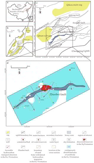
Figure 1.
Structural location and division of structural units in Chengbei fault terrace zone, Qikou Sag, Bohai Bay Basin, Eastern China [24] (modified from Liao et al., 2021): (a) the location of Bohai Bay Basin in China; (b) the location of region of interest in Bay Basin; (c) the location of Zhaobei Fault in Qikou sag; (d) the location of wells and the cross-section in Es1L Formation.
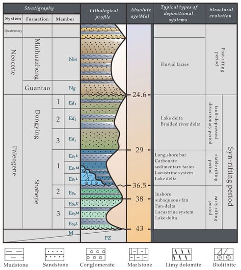
Figure 2.
Basin-filling evolution and stratigraphic sequence division of the Qikou Sag [29] (modified from Huang et al., 2012).
3. Methods
3.1. The Mechanism of Hydrocarbon Adjustment by Faults in the Slope Area Outside of the Source and the Favorable Sites for the Adjustment
The shallow hydrocarbon accumulation model in the slope area outside of the source in the hydrocarbon-bearing basin should be as follows: the lateral migration of hydrocarbons through the sand carrier is interrupted when the sand body encounters the conduit fault and the overlying regional mudstone seal rock intersecting the fault is leaking. The hydrocarbon is adjusted by the fault to transport vertically to the shallow layers through the leakage part of the regional mudstone seal rock and is collected in the shallow trap near the fault and finally forms the hydrocarbon accumulation, as shown in Figure 3.
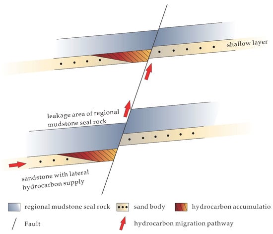
Figure 3.
Schematic diagram of the oil and gas adjustment mechanism of the fault to the shallow layer in the slope area outside of the source.
The hydrocarbon accumulation model mentioned above has demonstrated that the favorable sites of the fault for the hydrocarbon adjustment to the shallow layer in the slope area outside the source should be the coupling site of the positions of the sand carrier with lateral hydrocarbon supply, parts of conduit faults with hydrocarbon migration, and the hydrocarbon leakage area of regional mudstone seal rock, as shown in Figure 4.
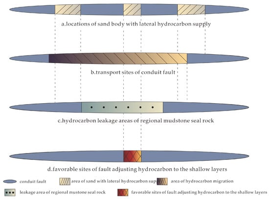
Figure 4.
Diagram illustrating the determination of the favorable location of the fault, adjusting oil and gas to the shallow layer in the slope area outside of the source.
The four diagrams above depict different delineations of regions along the same fault in a plan view. To obtain the composite regional plan view of the favorable sites of fault-adjusting hydrocarbon to the shallow layers, as shown in Figure 4d, which is the contained area of Figure 4a–c, the locations of sand bodies with lateral hydrocarbon supply shown in Figure 4a and the transport sites of conduit faults shown in Figure 4b, as well as the hydrocarbon leakage areas of the regional mudstone seal rock shown in Figure 4c, need to be identified, and the steps are shown in Section 3.2.
3.2. A Method for the Prediction of Favorable Sites of the Fault for the Adjustment of Hydrocarbon to the Shallow in Slope Areas Outside of the Source
The previous sections have proven that to predict the parts of faults prone to the adjustment of hydrocarbon to the shallow in the slope area outside of the source, it is inevitable to carve out the lateral hydrocarbon supply site of the sand body, the migration site of the conduit fault, and the hydrocarbon leakage part of the regional mudstone seal rock.
The sand body’s lateral oil and gas supply area can be determined by identifying the area of the sand body capable of lateral oil and gas migration and intersecting with the conduit fault, as shown in Figure 5. Among these, the former can be obtained by determining the distribution of connected sand bodies in the slope area outside the source and the paleo-potential energy of hydrocarbon at the top interface of the studied strata and then superimposing them, as shown in Figure 6. The specific steps are as follows. Based on the drilling data, we can calculate the sand–shale ratio of the studied strata in the slope area outside the source and make a plane of its distribution. The minimum sand–shale ratio of formation required for the sand body to connect is determined using the method from the literature [30]. Using the cutoff value, we can determine the distribution of connected sand bodies by excluding areas of sand bodies with the sand-to-shale ratio of studied layers smaller than the value, as shown in Figure 6. Three-dimensional seismic data are used to map the current burial depth of the top interface of the stratigraphic layer in the slope area outside the source [31]. The paleo-burial depth during the oil and gas accumulation period is recovered by the method from the literature [32]. After conversion, the value of the paleo-potential energy of hydrocarbon is derived by equation 1. Based on these values, the planar distribution map of the hydrocarbon paleo-potential energy can be drawn (Figure 6). By superimposing the distribution of connected sand bodies in the slope area outside the source and the distribution of hydrocarbon paleo-potential energy at the top interface of the formation, we can obtain the areas of sand bodies with lateral hydrocarbon migration, as shown in Figure 6.
where: Φ—hydrocarbon potential energy value, kJ; Z—burial depth, m; P—fluid pressure, MPa (its magnitude is equal to Z, where is the density of formation water, g/cm3); ρ—hydrocarbon density, g/cm3; and g—gravitational acceleration, m/s2.
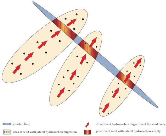
Figure 5.
Determination diagram of the position of the sand body with lateral oil and gas supply.
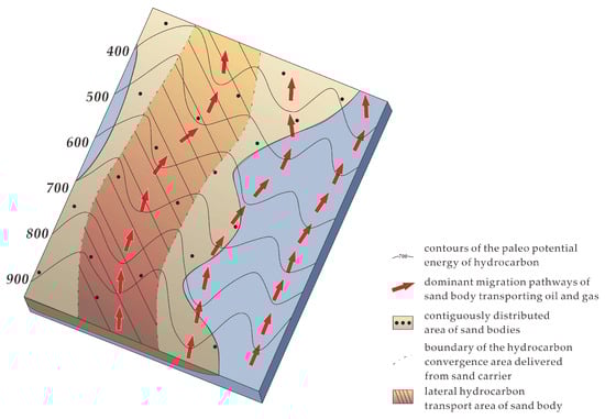
Figure 6.
Schematic diagram of the determination of the lateral hydrocarbon transport area of the sand body. The contiguously distributed area of the sand body was obtained by comparing and identifying regions where the sand–shale ratio exceed the minimum sand–shale ratio.
The area of sand with lateral hydrocarbon migration, which is shown in Figure 5, was determined by referring to the contours illustrating the distribution of hydrocarbon potential energy obtained, and the contiguous area of sand bodies acquired the superposition, as shown in Figure 6.
To determine the favorable area of the conduit faults for the hydrocarbon migration, 3D seismic data are used to first derive the fault throw of the stratigraphic layer where the sand carrier is located. The fault paleo-displacement recovery method in the literature [33] is used to recover the paleo-displacement of the conduit fault during the period of oil and gas accumulation. Then, the fault paleo-displacement is divided by the time with active faulting to determine the paleo-activity rate of the conduit fault. We apply the methods of determining the minimum activity rate of the fault, which acts as a conduit for the migration of oil and gas, from the literature [34] to the slope area outside the source and circle together the parts of the conduit fault where its paleo-activity rate is greater than or equal to the minimum activity rate. Based on these calculations, we can predict the favorable parts of the conduit fault for the migration of oil and gas, as shown in Figure 4.
To determine the hydrocarbon leakage sites of the overlying regional mudstone seal rock, it is essential to determine the paleo-break thickness of the studied regional mudstone seal rock during the period of hydrocarbon accumulation and the minimum break thickness required for the regional mudstone seal rock to seal. Using the drilling and 3D seismic data, the displacement of the fault and the thickness of regional mudstone seal rock can be estimated. Afterward, we use the recovery methods from the literature, [33] and [34], respectively, to recover the paleo-displacement of the conduit fault and the paleo-thickness of the regional mudstone seal rock during the oil and gas accumulation period [35]. Then, the paleo-break thickness of the studied regional mudstone seal rock can be derived by subtracting the paleo-displacement from the paleo-thickness. We use the method from the literature [36] to determine the minimum break thickness required to seal the oil and gas in the regional mudstone seal rock. By comparing the paleo-break thickness of the studied regional mudstone seal rock and the minimum value, the area where the former is less than the latter is taken as the oil and gas leakage site of the regional mudstone seal rock (Figure 4).
By superimposing the lateral oil and gas supply sites of the sand body, the hydrocarbon transport site of the conduit fault, and the oil and gas leakage location of the regional mudstone seal rock, we can determine the favorable site of the fault for hydrocarbon adjustment to the shallow layer in the slope area outside the source (Figure 4).
3.3. Case Study
To obtain the favorable site of the Zhaobei Fault for the adjustment of the hydrocarbon from the Es1L Formation to the shallow Guantao Formation, it is necessary to determine the lateral hydrocarbon supply area of the sand body in the Es1L Formation, the locations with hydrocarbon migration in the Zhaobei Fault, and the leakage area of the mudstone seal rock in the Es1M Formation and Dongying Formation. The steps are shown in Section 4. Alternatively, refer to Table A1 for a more comprehensive description of the methods and case applications.
4. Results and Discussion
Figure 7b shows that the oil and gas from the locations of sand bodies with lateral hydrocarbon supply in the Es1L Formation require migration through the leakage areas of regional mudstone seal rock within the Es1M Formation and the Ed Formation along the Zhaobei Fault (Figure 7c) in order to accumulate in the Ng Formation. This means that it is necessary to first obtain the locations with hydrocarbon migration, which are shown in Figure 7a and Figure 4a, the leakage area of the mudstone seal rock, which is shown in Figure 7a and Figure 4c, and the location with hydrocarbon migration, which is shown in Figure 7a and Figure 4b, and then find their overlapping area in the Zhaobei Fault.
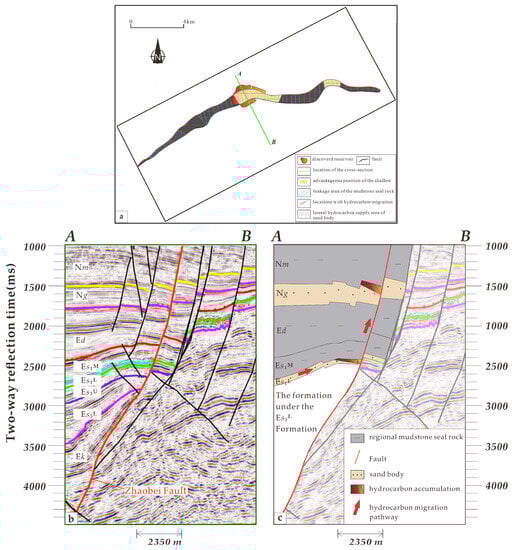
Figure 7.
(a) The relationship between the Guantao oil and gas show and the favorable parts of the Zhaobei Fault that adjust hydrocarbon from the Es1L to the shallow Guantao Formation. (b) Seismic section across the Zhaobei Fault; the fault is dipping towards the north-northwest with a dip angle ranging from 22° to 77°. (c) The pathway of hydrocarbon migration from Es1L to Ng.
Based on the drill data and 3D seismic data, we apply the method described before to predict the area of the sand body that has lateral oil and gas migration in the Es1L Formation near the Zhaobei Fault (Figure 8 [37]). Figure 8 shows that four areas of the sand body capable of lateral oil and gas migration are developed in the Es1L Formation near the Zhaobei Fault, among which three are distributed in the west and only one tiny spot is developed in the east. By superimposing the above-mentioned areas and the distribution of the Zhaobei Fault, the area of the sand bodies with lateral hydrocarbon supply in the Es1L Formation near the Zhaobei Fault can be identified. As shown in Figure 7, there are a total of four locations suited for the lateral oil and gas supply, of which three are on the western side of the fault and one is on the eastern side.
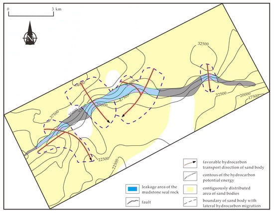
Figure 8.
Determination of the position of the sand body with lateral oil and gas transportation in the Es1L Formation near the Zhaobei Fault.
We first use 3D seismic data to calculate the fault throw of the Zhaobei Fault in the Es1L Formation. Then, we use the method described in the literature [33] to recover the paleo-displacement of the fault during the middle or late deposition period of the Minghuazhen Formation [38], which is the time during which the oil and gas accumulations were formed. Afterward, by dividing the paleo-displacement by the period with active faulting, we can calculate the paleo-activity rate of different locations of the Zhaobei Fault in the Es1L Formation (Figure 9). Figure 9 shows that the paleo-activity rate of the Zhaobei Fault in the Es1L Formation is relatively large, except for the western end and, locally, the central part. The minimum fault activity rate required to transport hydrocarbons in the Qikou Sag is about 4 m/Ma [39]. Therefore, the entire Zhaobei Fault can transport hydrocarbons (Figure 9).
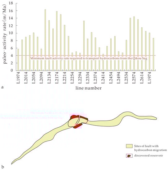
Figure 9.
Determination of the oil and gas migration area of the Zhaobei Fault. (a) Column chart of the paleo-activity rate of the Zhaobei Fault. (b) Sites of fault with hydrocarbon migration in the Zhaobei Fault.
Based on the drill and 3D seismic data, we calculate the fault displacement of the Zhaobei Fault and the thickness of the regional mudstone seal rock in the Es1M Formation and Ed2 Formation. Then, we apply the paleo-displacement recovery method [33] and the paleo-thickness recovery method [35] to recover the paleo-displacement of the Zhaobei Fault and the paleostratigraphic thickness of the regional mudstone seal rock in the Es1M Formation and Ed2 Formation during the middle and late sedimentary period of the Minghuazhen Formation [38], which is the period of hydrocarbon accumulation. By subtracting the two, we derive the paleostratigraphic break thickness of the regional mudstone seal rock in the Es1M Formation and Ed2 Formation at the Zhaobei Fault, respectively. The minimum break thickness of the regional mudstone seal rock in the Es1M Formation and Ed2 Formation in Qikou Sag required to seal hydrocarbon is around 159 m and 236 m [40], respectively. Accordingly, we can obtain the hydrocarbon leakage area of the regional mudstone seal rock in the Es1M Formation and Ed2 Formation at the Zhaobei Fault, respectively, and the results are shown in Figure 10. Most of the regional mudstone seal rock in the Es1M Formation at the Zhaobei Fault is leaking, except only locally in the western part, as shown in Figure 10a. The regional mudstone seal rock in the Ed2 Formation at Zhaobei Fault is sealing only in the western part where the rest is leaking, as shown in Figure 10b.
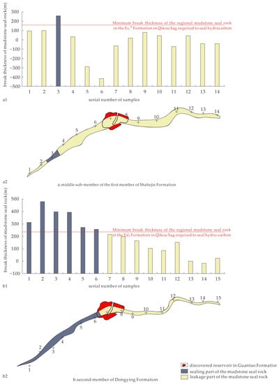
Figure 10.
Determination of leakage position of regional mudstone seal rock in the Es1L Formation and Ed2 Formation at Zhaobei Fault. (a1) Column chart of break thickness of mudstone seal rock of the Zhaobei Fault in Es1M. (b1) The Leakage part of the mudstone sealrock of the middle sub-member of first member of Shahejie Formation in the Zhaobei Fault. (a2) Column chart of break thickness of mudstone seal rock of the Zhaobei Fault in Ed2. (b2) The Leakage part of the mudstone sealrock of the second member of Dongying Formation in the Zhaobei Fault.
By superimposing the identified areas of the sand body with oil and gas supply in the Es1L Formation, the parts of the Zhaobei Fault with oil and gas migration, and the oil and gas leakage areas of the regional mudstone seal rock in the Es1M Formation and Ed2 Formation, we can obtain the favorable parts of the Zhaobei Fault for hydrocarbon adjustment from the Es1L Formation to the shallow Guantao Formation, as shown in Figure 7. The results show that most of the favorable sites are distributed in the central part of the fault, and only a few sites are in the eastern part.
Figure 7 shows that, until now, most of the oil and gas found in the Guantao Formation close to the Zhaobei Fault is located in its middle part, which is exactly located at the favorable area for the adjustment of the oil and gas from the Es1L Formation to the shallow Guantao Formation by the Zhaobei Fault. The reason is that, only in this area, oil and gas accumulations can form in the shallow Guantao Formation after obtaining oil and gas from the lateral supply of the sand carrier in the Es1L Formation and vertical migration along the favorable transport parts of the Zhaobei Fault through the leakage area of the regional mudstone seal rock in the Es1M Formation and Ed2 Formation. Shallow oil and gas are often found by drilling in these areas.
5. Conclusions
(1) This method primarily focuses on predicting the favorable site in the shallow layers of slope areas located outside the hydrocarbon source, which is accumulated by the hydrocarbon from the deep layers through the normal faults in a hydrocarbon-rich basin characterized by sandstone and mudstone lithology.
(2) To determine the favorable fault areas for adjusting hydrocarbons, the following steps can be followed.
Firstly, obtain the area of the connected sand bodies, the distribution of the paleo-potential energy of hydrocarbons, and the location of conduit faults to determine the lateral oil and gas supply sites of the sand body.
Secondly, assess the paleostratigraphic activity rate of conduit faults and determine the minimum activity rate required for oil and gas migration along faults to identify the oil and gas migration site of the transporting faults.
Lastly, evaluate the paleostratigraphic break thickness of the regional mudstone seal rock and determine the minimum break thickness needed for the effective sealing of oil and gas to identify the oil and gas leakage site.
By overlapping these areas, the favorable fault areas for adjusting hydrocarbons outside the source can be identified.
(3) Through the prediction using this method, it has been found that the favorable areas for adjusting hydrocarbons of the fault from the Es1L Formation to the shallow Guantao Formation of the Zhaobei Fault are mainly concentrated in the central part of the Zhaobei Fault, with a small favorable area also located in the eastern part. This discovery is consistent with the oil and gas discoveries in the Guantao Formation of the central Zhaobei Fault.
(4) The development of the favorable fault site, mentioned in the previous text, for adjusting oil and gas to the shallow layers in the slope area outside the source, creates a more advantageous condition for the convergence of shallow oil and gas, leading to the formation of accumulations. The more developed the favorable areas are, the more advantageous it is for shallow oil and gas to form accumulations. This method has the capability to predict such shallow oil and gas reservoirs and identify more favorable exploration areas. However, the current application of this method still has significant limitations. In the future, by incorporating more variables, this method can be made applicable to a wide variety of basins.
Author Contributions
Conceptualization, H.Y., L.Z. and Y.Z.; methodology, H.Y.; software, H.Y.; validation, H.Y., L.Z. and Y.Z.; formal analysis, H.Y.; investigation, H.Y.; resources, H.Y.; data curation, Y.Y.; writing—original draft preparation, H.Y.; writing—review and editing, H.Y.; visualization, H.Y. and Y.Z.; supervision, H.Y.; project administration, H.Y. and Y.W.; funding acquisition, H.Y. All authors have read and agreed to the published version of the manuscript.
Funding
This study was supported by the Key Research and Development Program of Heilongjiang Province (No. JD22A022), the Natural Science Foundation of Heilongjiang Province of China (No. LH2022D013, No. LH2023D005), and the Natural Science Foundation of Central Support Project for Young Talents in Local Universities in Heilongjiang Province (No. 14011202101).
Data Availability Statement
Not applicable.
Acknowledgments
We are very grateful for the financial support provided by the State Key Laboratory of Shale Oil and Gas Enrichment Mechanisms and Efficient Development towards this project.
Conflicts of Interest
The authors declare no conflict of interest.
Appendix A

Table A1.
The method summary table.
Table A1.
The method summary table.
| Target Variable | The Source of the Method | The Description of the Method | The Results in the Case | Purpose | |
|---|---|---|---|---|---|
| 1 | The minimum sand–shale ratio | [30] | Count all of the oil wells in the research area and record the sand–shale ratio of all oil wells, where the minimum value is the minimum sand–shale ratio. | 18% (cut of value) | The contiguous area of sand bodies can be obtained by comparing and identifying regions where the sand–shale ratio exceeds the cut-off value (the minimum sand–shale ratio). |
| 2 | The paleo-burial depth during the hydrocarbon accumulation period | [32] | The stratigraphic profile comparison method is utilized to approximately restore the erosion thickness of the stratigraphic layers. Subsequently, the precise calculation of the erosion volume is carried out using the vitrinite reflectance, and correction is made to the plane trend surface restoring method (the data are from 3D seismic data). | In order to calculate the hydrocarbon potential energy value using equation 1 in this study, it is necessary to first obtain the value of the burial depth. | |
| 3 | The hydrocarbon potential energy value | [30] | The value of hydrocarbon potential energy was derived by incorporating the converted results from Method 1 and Method 2 by equation 1. | Refer to the contours of the hydrocarbon potential energy shown in Figure 8. | To determine the location of the sand body with lateral hydrocarbon supply shown in Figure 4a, it is necessary to refer to the contiguous area of sand bodies identified using Method 1 and the results obtained from Method 3; namely, the contours illustrating the distribution of hydrocarbon potential energy. |
| 4 | The location of the sand body with lateral hydrocarbon supply | Referring to the contours illustrating the distribution of hydrocarbon potential energy obtained from Method 3 and the contiguous area of sand bodies acquired from Method 1, the superposition of these two components reveals the location of the sand body with lateral hydrocarbon supply. | Refer to the lateral hydrocarbon supply area of the sand body shown in Figure 7a. | To determine the favorable sites of fault-adjusting hydrocarbon to the shallow layers shown in Figure 4d, it is necessary to refer to the locations of the sand body with lateral hydrocarbon supply shown in Figure 4a. | |
| 5 | The paleo-displacement of the conduit fault during the accumulation period | [33] | Using the maximum offset subtraction method, the fault throw of the stratigraphic layer containing the sand carrier is deduced from the 3D seismic data. This allows for the reconstruction of the paleo-displacement of the conduit fault during the oil and gas accumulation period. | Determining the paleo-activity rate of the conduit fault requires dividing the fault paleo-displacement by the time period of active faulting. | |
| 6 | The paleo-activity rate of the conduit fault | Dividing the fault paleo-displacement by the time period of active faulting to determine the paleo-activity rate of the conduit fault. | Refer to the paleo-activity rate shown in Figure 9a. | The determination of oil and gas migration parts of the conduit fault by comparing and identifying regions where the paleo-activity rate of the conduit fault (result from Method 6) exceeds the minimum fault activity rate. | |
| 7 | The minimum activity rate of the fault for oil and gas migration | [34] | Determining the minimum activity rate of the fault for oil and gas migration based on the relationship between the paleo-activity rate of the fault at well-known locations and the distribution of oil and gas, similar to Method 1. | 4 m/ma | The determination of oil and gas migration parts of the conduit fault by comparing and identifying regions where the paleo-activity rate of the conduit fault exceeds the minimum fault activity rate (result from Method 7). |
| 8 | Transport sites of the conduit fault | By referring to the paleo-activity rate of the conduit fault obtained from Method 6 and the minimum activity rate of the fault for oil and gas migration determined from Method 7, the transport sites of the conduit fault can be identified. | Refer to the sites of the fault with hydrocarbon migration shown in Figure 9b. | To determine the favorable sites of fault-adjusting hydrocarbon to the shallow layers shown in Figure 4d, it is necessary to refer to the transport sites of the conduit fault shown in Figure 4b. | |
| 9 | The paleo-thickness of the regional mudstone seal rock during the hydrocarbon accumulation period | [35] | Taking into account the principles of constant area and constant length, as well as considering the bend–slip mechanism, the locations with weaker or no tectonic deformation are used as reference points for cross-sectional restoration. | Derive the paleo-break thickness of the studied regional mudstone seal rock by subtracting the paleo-displacement (result from Method 5) from the paleo-thickness (result from Method 9). | |
| 10 | The paleo-break thickness of the studied regional mudstone seal rock | Subtracting the paleo-displacement (result from Method 5) from the paleo-thickness (result from Method 9). | Refer to the break thickness of mudstone and rock shown in Figure 10a1 and b1 | The leakage part of the mudstone seal rock can be obtained by comparing and identifying regions where the paleo-break thickness of the studied regional mudstone seal rock is smaller than the minimum break thickness required to seal the oil and gas in the regional mudstone seal rock. | |
| 11 | The minimum break thickness required to seal the oil and gas in the regional mudstone seal rock | [36] | By finding the minimum value of seal break thickness in the wells that have encountered oil in the research area. | 159 m in Es1M formation; 236 m in Ed2 formation | To determine the leakage part of the mudstone seal rock, it is necessary to refer to the minimum break thickness. |
| 12 | The leakage part of the mudstone seal rock | The part where the paleo-break thickness of the studied regional mudstone seal rock is smaller than the minimum break thickness required to seal the oil and gas in the regional mudstone seal rock. In this case, the leakage part of the two formations should be taken into account. | Refer to the leakage area of the mudstone seal rock shown in Figure 7a. | To determine the favorable sites of fault-adjusting hydrocarbon to the shallow layers shown in Figure 4d, it is necessary to refer to the hydrocarbon leakage areas of regional mudstone seal rock, shown in Figure 4c. | |
| 13 | The favorable sites of fault-adjusting hydrocarbon to the shallow layers | The overlapping area in the favorable sites of fault-adjusting hydrocarbon to the shallow layers (the results from Method 4), the transport sites of the conduit fault (the results from Method 8), and the leakage part of the mudstone seal rock (the results from Method 12). | Refer to the advantageous position of the shallow shown in Figure 7a. | To obtain the favorable sites of fault-adjusting hydrocarbon to the shallow layers. |
References
- Torabi, A.; Fossen, H.; Braathen, A. Insight into petrophysical properties of deformed sandstone reservoirs. AAPG Bull. 2013, 97, 619–637. [Google Scholar] [CrossRef]
- Palhano, L.C.; Nogueira, F.C.C.; Marques, F.O.; Vasconcelos, D.L.; Bezerra, F.H.; Souza, J.A.B.; Nicchio, M.A.; Reyes Perez, Y.A.; Balsamo, F. Influence of hydrothermal silicification on the physical properties of a basin-boundary fault affecting arkosic porous sandstones, Rio do Peixe Basin, Brazil. Mar. Pet. Geol. 2023, 148, 106062. [Google Scholar] [CrossRef]
- Smith, D.A. Theoretical consideration of sealing and nonsealing faults. AAPG Bull. 1966, 50, 363–374. [Google Scholar]
- Fisher, Q.J.; Casey, M.; Harris, S.D.; Knipe, R.J. Fluid-flow properties of faults in sandstone: The importance of temperature history. Geology 2003, 31, 965–968. [Google Scholar] [CrossRef]
- Wüstefeld, P.; Hilse, U.; Lüders, V.; Wemmer, K.; Koehrer, B.; Hilgers, C. Kilometer-scale fault-related thermal anomalies in tight gas sandstones. Mar. Pet. Geol. 2017, 86, 288–303. [Google Scholar] [CrossRef]
- Fu, G.; Li, J.J.; Yu, T. Improvement of method for timing of hydrocarbon migration along source rock-rooted faults and its application: A case of the South Dagang fault in Qikou Sag, Bohai Bay Basin. Oil Gas Geol. 2022, 43, 1481–1488. [Google Scholar]
- Yuan, S.Q.; Dong, X.W.; Zhou, F.C.; Rao, M.; Liu, A.P.; Wang, Z. Main controlling factors of hydrocarbon accumulation and enrichment and high yield in stratigraphic-lithological reservoirs outside the source area. Acta Pet. Sin. 2016, 37, 10–18. [Google Scholar]
- Liu, J.Q.; Wang, H.X.; Lyu, Y.F.; Sun, T.W.; Zhang, M.D.; He, W.; Sun, Y.H.; Zhang, T.; Wang, C.; Cao, L.Z. Reservoir controlling differences between consequent faults and antithetic faults in slope area outside of source: A case study of the south-central Wenan slope of Jizhong Depression, Bohai Bay Basin, East China. Pet. Explor. Recovery Dev. 2018, 45, 88–98. [Google Scholar] [CrossRef]
- Yang, S.R.; Gao, G.; Zhang, Y.C.; Guo, Y.; Wang, J.W.; Tian, C.B.; Gang, W.Z. Oil-source correlation and model of migration and accumulation of shallow-middle crude oil in No.2 Structural Belt. Pet. Geol. Recovery Effic. 2018, 25, 30–36. [Google Scholar]
- Fu, G.; Xue, Y.C. Controlling effect of match relation between seal rock and sourcerock in time and space on formation of oil or gas pools. J. Mineral. Petrol. 2001, 21, 56–61. [Google Scholar]
- Fu, G.; Fu, X.F.; Lü, Y.F. Effect of thrusts in the migration and accumulation of oil and gas in Kuche depression, Xinjiang. Geol. Sci. Technol. Inf. 2004, 23, 73–77. [Google Scholar]
- Chen, Y.B.; Cheng, X.G.; Zhang, H.; Li, C.Y.; Ma, Y.P.; Wang, G.D. Fault characteristics and control on hydrocarbon accumulation of middle-shallow layers in the slope zone of Mahu sag, Junggar Basin, NW China. Pet. Explor. Dev. 2018, 45, 985–994. [Google Scholar] [CrossRef]
- Hu, L.; Jin, Q.Y.; Yang, X.B.; Hu, D.S.; Lu, M. Structure evolution and middle-shallow hydrocarbon enrichment patters in the Eastern Wushi Sag. Spec. Oil Gas Reserv. 2020, 27, 68–73. [Google Scholar]
- Liu, L.; Sun, Y.H.; Chen, C.; Lou, R.; Wang, Q. Fault reactivation in No.4 structural zone and its control on oil and gas accumulation in Nanpu sag, Bohai Bay Basin, China. Pet. Explor. Dev. 2022, 49, 716–727. [Google Scholar] [CrossRef]
- Yang, J.; Shen, Z.M.; Wang, G.J.; Cheng, T.J. Characteristics of hydrocarbon micro-leakage and its abnormal genesis in Linnan-Qianguantun area, Jiyang depression, Shandong, China. J. Chengdu Univ. Technol. Sci. Technol. Ed. 2015, 42, 709–718. [Google Scholar]
- Hu, X.L.; Fu, G. Control of fault connecting source rock and reservoir on lower generation and upper storage pattern oil-gas accumulation and distribution: Taking middle-shallow area of Nanpu Depression as an example. Fault Block Oil Gas Field 2014, 21, 273–277. [Google Scholar]
- Fu, G.; Han, X. Methodology for predicting transfer position of oil and gas transmission from fault in depression to sand body in slope area. J. China Univ. Pet. Ed. Nat. Sci. 2021, 45, 45–50. [Google Scholar]
- Fu, G.; Li, S.Z.; Yang, D.X. A method forecasting distribution areas of fault transporting oil-gas migration and its application. Acta Sedimentol. Sin. 2017, 35, 592–599. [Google Scholar]
- Gao, N.; Fu, G.; Wang, H. Time-space matching relation between source rock and oil-source faults of Ed1 Member in Nanpu Sag and its control effect on hydrocarbon accumulation. J. Xi’an Shiyou Univ. Nat. Sci. 2017, 32, 11–17. [Google Scholar]
- Luo, Q.; Huang, H.D.; Li, Y.X. Petroleum accumulating feature and fault controlling petroleum accumulation model on the down block of shallow slip fault in north margin of Qaidam Basin. J. China Univ. Pet. Ed. Nat. Sci. 2009, 33, 34–38. [Google Scholar]
- Xue, Y.A.; Niu, C.M.; Wang, D.Y.; Yang, C.C.; Liu, Y.J.; Zhang, H.G.; Wang, Y.C. New understanding of shallow hydrocarbon migration and new exploration progress in the Bohai Sea. Acta Pet. Sin. 2019, 40, 29–37. [Google Scholar]
- Chen, G.; Bian, B.L.; Li, X.; Liu, G.; Gong, D.Y.; Zeng, D.L. Transport system and its control on reservoir formation of Jurassic-Cretaceous in hinterland of Junggar Basin. Lithol. Reserv. 2021, 33, 46–56. [Google Scholar]
- Xue, Y.A.; Yang, H.F.; Huang, J.B.; Yang, C.C.; Liu, Y.J.; Wang, L.L. Technological and theoretical innovations in the shallow hydrocarbon migration and accumulation of the Bohai sea and the exploration breakthroughs. China Offshore Oil Gas 2020, 32, 14–23. [Google Scholar]
- Fu, G.; Liang, M.G.; Li, J.R. Improved prediction method of favorable positions for oil and gas transport of active oil-source faults. J. China Univ. Pet. Ed. Nat. Sci. 2021, 45, 42–50. [Google Scholar]
- Fu, G.; Dong, J.M.; Peng, W.T. Determination method and application for the conversion period of fault-seal rock configuration leakage and sealing. Acta Sedimentol. Sin. 2020, 38, 868–875. [Google Scholar]
- Cheng, P.; Xiao, X.M.; Fan, Q.Z.; Gao, P. Oil Retention and Its Main Controlling Factors in Lacustrine Shales from the Dongying Sag, Bohai Bay Basin, Eastern China. Energies 2022, 15, 4270. [Google Scholar] [CrossRef]
- Liu, J.L.; Han, S.B.; Yang, F.T.; Yue, D.D. The Hydraulic Connection Analysis of Dongying Geothermal Fluid Using Hydrochemical Information and Isotope Data in Tianjin Coastal Regions. Water 2023, 15, 1235. [Google Scholar] [CrossRef]
- Liao, W.H.; Chen, D.X.; Zeng, J.H.; Jiang, W.Y.; Liu, Z.Y. Configuration types of fault-sand in Chengbei Fault Terrace Zone of Qikou Sag and its control on hydrocarbon accumulation. J. Jilin Univ. Earth Sci. Ed. 2021, 51, 336–354. [Google Scholar]
- Huang, C.Y.; Wang, H.; Wu, Y.P.; Wang, J.H.; Chen, S.; Ren, P.G.; Liao, Y.T.; Zhao, S.E.; Xia, C.Y. Genetic types and sequence stratigraphy models of Palaeogene slope break belts in Qikou Sag, Huanghua Depression, Bohai Bay Basin, Eastern China. Sediment. Geol. 2012, 261–262, 65–76. [Google Scholar] [CrossRef]
- Fu, G.; Zhao, K.; Han, X. Lateral distributary migration of oil and gas from fault to sandbody in the Nan 1 formation of the Sudeerte area, and its relationship with hydrocarbon accumulation. Geophys. Prospect. Pet. 2022, 61, 564–570. [Google Scholar]
- Zhao, Z.Z.; Zhong, G.J.; Sun, M.; Feng, C.M.; Tu, G.H.; Yi, H. Hydrocarbon Accumulation Analysis Based on Quasi-3D Semismic Date in the Turbulent Area of the Northern South China Sea. Mar. Sci. Eng. 2023, 11, 338. [Google Scholar] [CrossRef]
- Sun, P.; Guo, Z.Q.; He, W.Y.; Liu, W.H. Restoration of eroded thickness of the Neogene strata in the western Qaidam Basin and its significance for oil and gas occurrence. Acta Geol. Sin. Engl. Ed. 2017, 91, 1352–1362. [Google Scholar] [CrossRef]
- Fu, X.F.; Song, X.Q.; Wang, H.X.; Liu, H.T.; Wang, S.Y.; Meng, L.D. Comprehensive evaluation on hydrocarbon-bearing availability of fault traps in a rift basin: A case study of the Qikou Sag in the Bohai Bay Basin, China. Pet. Explor. Dev. 2021, 48, 677–686. [Google Scholar] [CrossRef]
- Fu, G.; Sha, Z.X.; Wang, H.W.; Jiang, W.Y.; Dong, X.Y. Research method and application of evolution form of oil and gas passage of oil source fault. Chin. J. Geol. 2022, 57, 127–138. [Google Scholar]
- Xiong, L.Q.; Yao, G.S.; Xiong, S.Y.; Shen, A.J.; Hao, Y. A method of stratum restoration for fault belt based on balanced cross-section: A case study of the middle Devonian Guanwushan Formation in the Longmenshan Area, Western Sichuan Basin, China. Geotecton. Metallog. 2019, 43, 1079–1093. [Google Scholar]
- Wu, Y.N.; Yuan, H.Q.; Zhang, Y.X.; Wang, Y.X. Restoration method of fault—Seal rock configuration sealing evolution stage and its application. Geol. Rev. 2022, 68, 1161–1169. [Google Scholar]
- Sun, Y.H.; Zhao, B.; Dong, Y.X.; Zheng, X.F.; Hu, M. Control of faults on hydrocarbon migration and accumulation in the Nanpu Sag. Oil Gas Geol. 2013, 34, 540–549. [Google Scholar]
- Zhao, X.Z.; Zhou, L.H.; Xiao, D.Q.; Pu, X.G.; Jiang, W.Y. Hydrocarbon accumulation and exploration practice of slope area in Qikou sag. Acta Pet. Sin. 2016, 37, 1–9. [Google Scholar]
- Fu, G.; Wang, H.W.; Han, G.M.; Pu, X.G. Prediction method the application of oil and gas accumulation favorable position near fault in slope area outside source. J. Jilin Univ. Earth Sci. Ed. 2021, 51, 1700–1708. [Google Scholar]
- Liang, M.G.; Fu, G.; Han, X.; Li, Q.Q. Mapping of oil-source faults in reservoir–cap rock combinations without a source rock. Energy Geosci. 2021, 3, 103–110. [Google Scholar] [CrossRef]
Disclaimer/Publisher’s Note: The statements, opinions and data contained in all publications are solely those of the individual author(s) and contributor(s) and not of MDPI and/or the editor(s). MDPI and/or the editor(s) disclaim responsibility for any injury to people or property resulting from any ideas, methods, instructions or products referred to in the content. |
© 2023 by the authors. Licensee MDPI, Basel, Switzerland. This article is an open access article distributed under the terms and conditions of the Creative Commons Attribution (CC BY) license (https://creativecommons.org/licenses/by/4.0/).