Abstract
Due to the success of oil and gas production, turbidites have become exploratory targets over the past 40 years in the rift and passive margin basins in the North and South Atlantic. The turbiditic reservoirs in rift and passive margin settings of Atlantic sedimentary basins located in Brazil (Campos Basin) and Portugal (Lusitanian Basin) represent potential economic units for the hydrocarbon exploration. However, despite being considered analogous reservoirs, these units present distinct potentials for the accumulation of hydrocarbons. In this context, the work presented discusses the results obtained from the analysis of static (source rock, reservoir rock, seal and trap) and dynamic elements (migration, tectonic, diagenetic and thermal processes) of both studied petroleum systems, using geological, seismic, well, geochemical and petrographic data. The developed methodology of multiscalar characterization of the two petroleum systems was successful, leading to a specific classification of the efficiency of the static and dynamic elements. These served as the basis for a petroleum systems analysis of the potential of turbiditic reservoirs in both analyzed basins. In the Campos Basin, the salt diapirs and the associated faults provided the origin of excellent migration routes for the hydrocarbons generated in lower intervals, allowing them to reach Cretaceous turbidite reservoirs. At Lusitanian Basin, the diagenetic processes reduced significantly the porosities of the potential turbiditic reservoirs, besides the intense influence of the salt tectonics that may have been responsible for the migration of hydrocarbons along faults or by their walls, towards upper formations and to the surface.
1. Introduction
In many sedimentary basins of the world, there are proven petroleum systems that have already produced drilled and yet-to-be-drilled prospects. Commercial prospecting of oil and/or gas from reservoirs depends on the efficiency of static and dynamic elements, and their associated processes. Therefore, it is essential to understand all the dynamic elements involved in the generation and evolution of a sedimentary basin. These consequently contribute to the good performance of the static elements of the petroleum systems, and their associated essential processes. In this context, multiscale analysis is necessary for a better understanding of each type of reservoir.
Although turbidite reservoirs do not represent the largest hydrocarbon reserves in the world, they have become of great interest to the hydrocarbon industry over the past 40 years [1]. In this article, we present the results obtained from the analysis of the static and dynamic elements of the petroleum systems contained in a case study that executed an analysis of petroleum systems of two turbidite reservoirs: the turbidite sandstones of the Carapebus Formation (Upper Cretaceous) of the Campos Group (oil producer of the Roncador Field in the Campos Basin, Brazil), and the reservoirs of prospects drilled in the sandstones of alluvial fans, deltas and turbidites of the Abadia Formation (Neo-Jurassic) in the Lusitanian Basin (Portugal).
According to the classic definition published in the AAPG Memoir 60 [1], a petroleum system encompasses a set of active source rocks and all the essential elements and processes necessary for the accumulation of oil and gas. According to the authors, the essential elements are: source rock, reservoir rock, seal rock and source rock burial (overburden). The processes associated with the essential elements include the formation of traps and the generation–migration–accumulation of oil. All elements must be positioned in time and space so that the processes necessary to form an oil accumulation can take place. Petroleum system studies describe the genetic relationship between a hydrocarbon generation kitchen and the resulting oil (oil and/or gas) accumulation. Proof of the existence of a petroleum system is the presence of hydrocarbons, even represented by a puff of gas or a drop of oil (low volume but high concentration).
Since the classic work of the AAPG Memoir 60 [2], various concepts of petroleum systems have been reviewed. The static elements of petroleum systems [3] are essentially the mappable elements related to sedimentary processes (depositional systems, involving aspects such as erosion/climate and rates of accumulation and preservation), namely: source rock, reservoir rock and sealing rock. A fourth, equally mappable element, is the trap [3], which developed in association with both depositional history (stratigraphic traps), diagenetics (diagenetic traps) and post-depositional tectonics (structural and geomorphic traps).
The dynamic elements of petroleum systems [3] consist of those that we can model and are associated with post-depositional dynamics, which include: tectonic (burial or subsidence history and associated overload, subsidence and uplift rates), and diagenetic and thermal (heat fluxes) processes. All these dynamic elements may influence the different petrophysical properties and permo-porous attributes of each studied reservoir rock, and its consequent exploratory success as an accumulator, or not, of hydrocarbons.
On the other hand, the static elements and their linked processes are directly associated with the geodynamic elements that affect the evolution of each sedimentary basin, which also include tectonic, diagenetics and thermal processes. Therefore, subsidence and uplift influence the distinct petrophysical characteristics of each reservoir rock under study, consequently directly impacting the exploratory success and the viability of hydrocarbon accumulations [3].
In regards to the basin geodynamics and their influence on dynamic elements, a sedimentary basin is not only composed by the source rocks, reservoir rocks and sealings, but the entire sedimentary column that plays an active and decisive role in the genesis, trapping and conservation of hydrocarbons. The formation of a petroleum system is the result of a succession of physical and chemical transformations (diagenesis, tectonic deformations, compaction, etc.), which affect the sediments and strictly control the genesis, concentration and dispersion of hydrocarbons. Important factors that control these transformations and even initiate them are the geodynamic movements of uplift and subsidence of the basin, in accordance with the mechanisms of tectonics, heat fluxes and gravity [4].
An analysis based on the multiscale characterization of the elements of the petroleum systems was carried out in order to confirm that the petroleum systems worked in the case study. This analysis sought to confirm the occurrence of the four static elements (source, reservoir and sealant rocks and traps), as well as the generation and migration of hydrocarbons (dynamic elements). To achieve this, all available data for each objective were studied, including: interpreted 2D seismic reflection lines; exploratory well data (composite profiles with logging data); geochemical data from source rocks; and petrographic analyses with the description of the diagenetic processes acting on the reservoir rocks. In this context, analysis of petroleum systems of the studied turbidite reservoirs was performed. These analyses were based on two studies: a table of the efficiency of the static and dynamic elements and of the synchronism and economic aspects of the two petroleum systems; and an illustrative scheme of static and dynamic elements of petroleum systems.
2. Geological Settings
In this section, the location maps (Figure 1), the stratigraphic charts and the petroleum systems event charts of the Campos and Lusitanian basins are presented, demonstrating the two petroleum systems addressed in the case study: Lagoa Feia-Carapebus and Cabaços-Abadia.
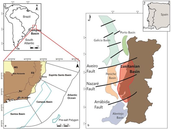
Figure 1.
Location maps of the Campos Basin (a), adapted from Bastos, [5] and the Lusitanian Basin (b), adapted from Pena dos Reis and Pimentel [6], in Brazil and Portugal, respectively.
2.1. Campos Basin
The Lagoa Feia-Carapebus petroleum system included in the case study of the present work had its generation in the Lagoa Feia Group shales and accumulation in the turbidites of the Carapebus Formation (Turonian-Miocen).
The Lagoa Feia-Carapebus petroleum system is shown in the stratigraphic chart of the Campos Basin (Figure 2), in which the source rocks of the Lagoa Feia Formation are indicated by the green circle and the turbidite sandstone reservoirs of the Carapebus Formation (Santonian, Campanian and Maastrichtian) are indicated by the yellow circles. The seal rocks are the shales of the Ubatuba Formation (UBT). The petroleum systems event chart for the Campos Basin is presented in Figure 3, with the positions of the source rock and the reservoir of the Lagoa Feia-Carapebus petroleum system.
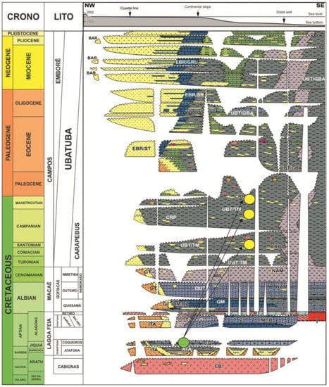
Figure 2.
Stratigraphic chart of the Campos Basin, adapted from Portella [7], showing the Lagoa Feia-Carapebus petroleum system. The source rocks of the Lagoa Feia Formation are indicated by the green circle and the turbidite sandstone reservoirs of the Carapebus Formation are indicated by the yellow circles. The seal rocks are the shales of the Ubatuba Formation (UBT).
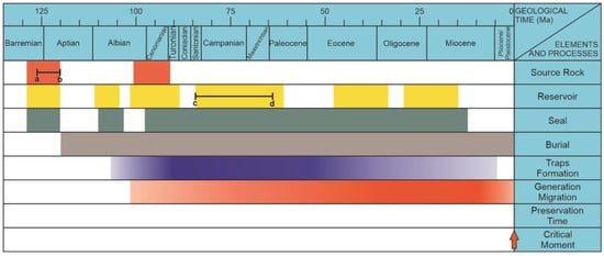
Figure 3.
Petroleum systems event chart of the Campos Basin, adapted from Alves [8]. Inside a–b line marks the period of generation (from Barremian to Aptian) and the c–d line indicates the period of the principle reservoirs (from Santonian to Maastrichtian) of the Lagoa Feia-Carapebus petroleum system.
2.2. Lusitanian Basin
The studied petroleum system, the Cabaços-Abadia of the Lusitanian Basin, involves the generation of petroleum by the shallow water transitional marine sediments of the Cabaços Oxfordian Formation (Neo-Jurassic) (Figure 4), composed of marly limestones deposited in lake, lagoon and coastal environments [9]. TOC values range between 2% and 5% (up to 30%), with a type III kerogen dominance [10].
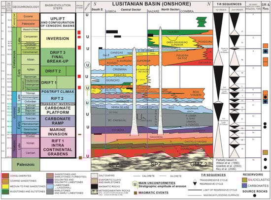
Figure 4.
Chronolitostratigraphic chart of the Lusitanian Basin, adapted from Pena dos Reis and Pimentel [6].
The oil migrated to Kimmeridgian (Upper Jurassic) turbidite sandstones belonging to the Abadia Formation [11] (Figure 4). This petroleum system was tested as a target in several exploratory wells drilled in the onshore of the Lusitanian Basin, in the Arruda, Turcifal and Bombarral sub-basins, in the central part of the basin. The hydrocarbons generated in the Cabaços Formation also migrated to the overlapping fractured Oxfordian marine limestones of the Montejunto Formation and to intervals with potential reservoir of the microbiolites of the Cabaços Formation [12].
The simplified petroleum systems of the Lusitanian Basin are presented in Figure 5, below. The studied petroleum system of Cabaços-Abadia in the case study is shown inside the blue dotted line.
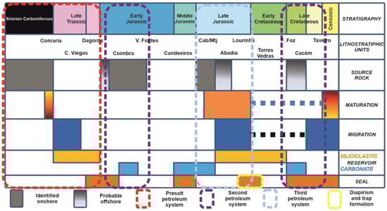
Figure 5.
Simplified petroleum systems of the Lusitanian Basin. The Cabaços-Abadia petroleum system is shown within the blue dotted line, referring to the third petroleum system, adapted from Pena dos Reis and Pimentel [6]. The oil is generated in the marly limestones of the Cabaços Formation and migrates to the turbidite sandy reservoirs of the Abadia Formation (modified).
3. Materials and Methods
3.1. Materials
The materials used for the research were the following: interpreted 2D seismic lines, composite profiles of exploration wells, results of geochemical analysis of source rocks and description of petrographic thin sections with photomicrographs.
3.1.1. Carapebus Formation
Figure 6 presents the map showing the Roncador Field (in orange), and the location of the interpreted 2D seismic lines 66-08 and 53-240 [13], used in the research. The seismic line 53-240 was chosen to be presented in the results (item 4), as it is more representative in terms of showing the connection of source rocks of the Lagoa Feia Formation with the turbidite reservoirs of the Carapebus Formation.
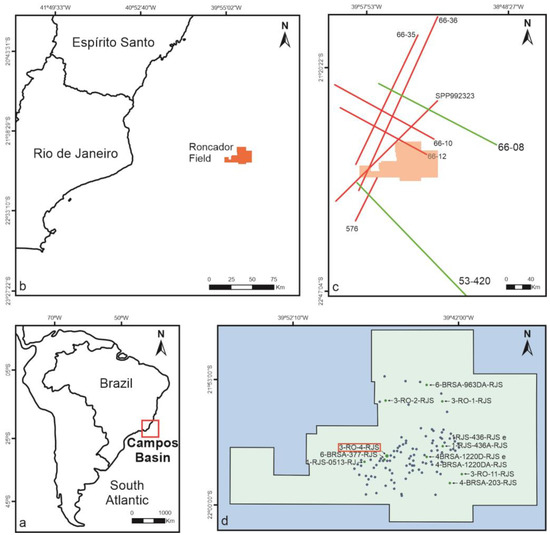
Figure 6.
Map of Brazil (a); Roncador field on the Campos Basin (b) adapted from Furlan [13]; location of the 2D seismic lines 66-08 and 53-420 (c) adapted from Furlan [13]; location of wells in the Roncador field (blue dots), of the analyzed wells (green dots) and of the well 3-RO-4-RJS (inside the red rectangle), selected to be presented in the results (d) adapted from Ref. [14].
Data from 12 exploration wells executed in the Roncador Field (Figure 6) were used in the investigation, whose well folders and composite profiles were downloaded from the ANP Exploration and Production Databank [14]. The 12 wells studied were the 1-RJS-436A-RJS, 1-RJS-436-RJS, 1-RJS-513-RJ, 3-RO-1-RJS, 3-RO-2-RJS, 3-RO-4-RJS, 3-RO-11-RJS, 4-BRSA-203-RJS, 4-BRSA-1220DA-RJS, 4-BRSA-1220D-RJS, 6-BRSA-377D-RJS and 6-BRSA-963DA-RJS.
The 3-RO-4-RJS well (inside the red rectangle—Figure 6d) was selected to be presented in the results as it is the most representative of the turbidite sandstone packages of the Carapebus Formation, with oil occurrences, capped by the shales of the Ubatuba Formation (sealing rock).
The geochemical profile of the source rocks of the Lagoa Feia Formation is presented in the results, proving their effectiveness in the Campos Basin.
Eighteen photomicrographs of thin sections from the turbidites of the Carapebus Formation [15] were analyzed in the research, divided by well: 06 from the Santonian turbidites of Well 03; 06 from the Campanian of Well 04; and 06 from the Maastrichtian of Well 05 (Figure 7). The thin sections of Well 05 were selected to be presented in the results, due to the Maastrichtian being the most important interval of turbidite sandstones in the Roncador Field.
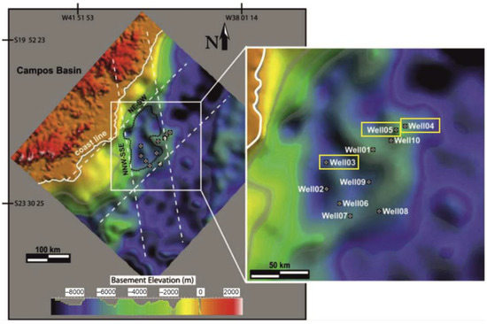
Figure 7.
Location of the well cores 03, 04 and 05 used for petrographic analysis of the turbidite reservoirs, respectively, of the Santonian, Campanian and Maastrichtian of Campos Basin [15].
3.1.2. Abadia Formation
Figure 8 presents the map showing the central sector of the Lusitanian Basin, and the location of the interpreted 2D seismic lines AR9-80 and H [16], used in the investigation, and the positions of the analyzed exploratory wells Benfeito-1 and Freixial-1. The seismic line AR9-80 was selected to be presented in the results, because it is the most representative, showing the listric faults that connect the source rocks of the Cabaços Formation with the potential turbiditic reservoirs of the Abadia Formation. A range of 204 m of the composite profile of the Benfeito-1 (Bf-1) exploratory well is presented on the results. This range clearly shows various levels of turbidite sandstones from the Cabritos Member with several gas shows, proving the effectiveness of the Cabaços-Abadia petroleum system.
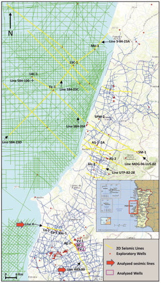
Figure 8.
Location map of the 2D analyzed seismic lines H and AR9-80. This last line with the analyzed exploration wells Freixial-1 (Fx-1) and Benfeito-1 (Bf-1), adapted from Ref. [16], was selected to be presented in the results.
Geochemical analysis of total organic carbon (TOC) and vitrinite reflectance from the source rocks of the Cabaços and Vale Verde Formations (Upper Jurassic) are presented in the results, in order to confirm the generating capacity of these rocks.
Seven photomicrographs of thin sections were selected with their respective descriptions of turbidite sandstones of the Abadia Formation: 03 (three) photomicrographs of the Benfeito-1 (Bf-1), in the following depth intervals: 895–900 m, 959–955 m and 980–985 m, and 4 (four) other photomicrographs of thin sections of plugs of the Freixial-1 exploratory well, at the following depths: 774.0 m (two units), 904.0 m and 936.0 m. Six photomicrographs were selected as the most representative and are presented in the results.
3.2. Methods
The multiscale analysis of petroleum systems was based on the multiscale reservoir characterization method (acronym CAMURES in Portuguese), which considers the visualization of the sedimentary record through the integrated application of a set of techniques and theories usual in sedimentary geology and based on the petroleum geology, directed to the research of mineral resources contained in sedimentary basins [17,18].
The analyses presented in this article were based on the evaluation of three studies: a table of static and dynamic elements, synchronism and economic aspects; an illustrative scheme of the analysis of static and dynamic elements of petroleum systems (Figure 8); and the calculation of the probability of geological success of the studied reservoirs.
Figure 9 shows the scheme of the interrelationship of the static elements (generator, reservoir, sealant and traps: SE1 to SE4) with the dynamic elements (generation, migration and accumulation: DE1 to DE3) of the petroleum systems and the factors and processes that influenced their formation, as well as the synchronism between these factors and dynamic elements, in time and space.
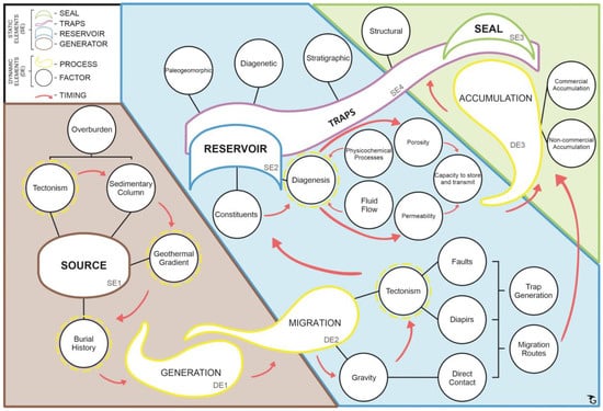
Figure 9.
Illustrative diagram of the factors and processes (dynamic elements) that affect the static elements of a petroleum system. The graphic arrangement of these elements was performed according to their moment of contribution within the petroleum system (timing).
For the source rock static element (SE1), the most influential factors are the overburden rocks, generated by the first phase of tectonism (responsible for the implementation of the basin) and constituted by the sedimentary column. The latter, in turn, affects the geothermal gradient, and also contributes to the formation of dynamic elements of generation (DE1) and migration (DE2), all interconnected by the active timing.
After the generation of hydrocarbons, other factors are responsible for helping them to migrate to the reservoir rocks (SE2), such as gravity and the tectonic phase active at this stage. The tectonism is responsible for the formation of faults and diapirism, which in turn constitute migration routes and promote the formation of traps capable of retaining hydrocarbons.
As a result of hydrocarbons reaching the reservoir rocks (SE2), factors such as their constituent minerals and the action of diagenetic processes will contribute to the formation of their permo-porous characteristics. The physicochemical processes and fluid flows acting on diagenesis directly influence the generation of porosity and permeability of reservoir rocks, and consequently their ability to retain and let the hydrocarbons flow.
The good permo-porous characteristics (porosity and permeability) are essential for the retention of hydrocarbons by the reservoir rock. However, it is also necessary to close the oil system by a sealing rock (SE3), thus forming the fourth static element that constitutes the trap (SE4). If the reservoir rock is sealed by the sealant rock, there will be the formation of a commercial accumulation of oil and/or gas (DE3), or non-commercial. The latter occurs if there is no sustained and stabilized hydrocarbon flow during the reservoir formation tests.
For the occurrence of a commercial accumulation, it is necessary that all static and dynamic elements originate and develop in an adequate space time scale, in the phenomenon reported as timing (indicated in the scheme of the Figure 8 by the red arrows).
The illustrative scheme of Figure 8 is divided into three color bands related to the static elements and the processes and active factors (dynamic elements) acting on them: the gray band, related to source rock (SE1); the blue band, relative to the reservoir (SE2) and the traps (SE4); and the green band, referring to the trapping of hydrocarbons, by the traps (SE4) and sealing rocks (SE3). The dynamic elements generation (DE1), migration (DE2) and accumulation (DE3) are distributed over the three bands of the static elements, along with the red arrows indicating the timing.
In addition to presenting the geological data that prove the petroleum systems, the probability of geological success (Pg) was calculated for each reservoir studied in the case study. The probability of geological success (Pg) was obtained by multiplying the probabilities of the following four factors of the play concept [19], expressed in notes from 0.0 to 1.0:
Pg = P source rock (Psr) × P reservoir (Pr) × P trap (Pt) × P dynamic (Pd)
Geological success is defined as reservoir capacity of having a sustained and stabilized flow in a hydrocarbon flow test, disregarding the occurrence only of oil and gas shows or hydrocarbon flows without pressure stabilization. This definition eliminates very low permeability reservoirs of limited area extent, biodegraded oils, and other marginal cases that cannot deliver a stabilized flow of hydrocarbons from a successful case [19].
After estimating the probability of all geological factors, the probability of success is calculated using the equation described, and consequently, the geological risk value. The calculated values for the probabilities of each one of the geological factors come from the knowledge about the multivariable database (data from different observation scales) of the studied petroleum system. In this context, the probability of geological success (Pg) of a reservoir depends on the quantity and quality of the available data and on the analysis of the coherence of these data by the explorationist’s evaluation.
The qualitative interpretation of geological hazard is expressed according to the geological success probability formula (Pg). The numerical ranges of the results of this equation are classified by geological risk ranges. The geological risk classifications are namely: very high risk (0.0–0.05), high risk (0.05–0.15), moderate risk (0.15–0.25), low risk (0.25–0.5) and very low risk (0.5–1.0) [19,20,21].
4. Results
Here, the results obtained through the multiscale characterization of static elements, dynamic elements, synchronism and economic aspects (calculation of the probability of geological success) of the two petroleum systems addressed in the case study are presented.
4.1. Campos Basin (Brazil)–Carapebus Formation
For the analysis of the static elements of the petroleum system of the Roncador Field at Campos Basin, Brazil, the following results are presented: interpreted 2D seismic reflection line 53–420; composite profile of the exploratory well 3-RO-4-RJS; geochemical profiles of the source rock of the Lagoa Feia Formation; petrographic analysis of the main reservoir rock of the Carapebus Formation with the description of the noted diagenetic processes and calculation of the probability of geological success.
Figure 10 shows the interpreted 2D seismic reflection line 53–420 [22], close to the ring fence area of Campo de Roncador, in the Campos Basin. The most important seismic reflectors were interpreted, being thus related: the top of the Aptian (corresponding to the base of the Retiro Formation–base of the salt), the top of the Macaé Group, the top of the Maastrichtian (which corresponds to the most important age of occurrence of the Cretaceous turbidite reservoirs), the top of the Oligocene, the top of the Ubatuba Formation of the Campos Group (the most important sealing rocks) and the top of the Emborê Formation. The geological faults and saline domes of the Retiro Formation were also interpreted.
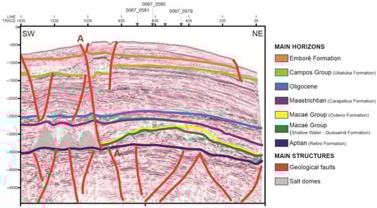
Figure 10.
Interpretation of the 2D seismic reflection line 53-420, near the ring fence area of the Roncador Field, in the Campos Basin, Brazil, adapted from Furlan and Vincentelli [22]. The Carapebus Formation reflector corresponds to the top of the Upper Cretaceous (Maastrichtian).
In the interpreted seismic section of the line 53-420 (Figure 10) it is possible to notice that the large faults of the rift and drift phases are connecting the source rocks of the Lagoa Feia Formation, marked by the top of the Aptian reflector (top of post-rift phase), with the turbidite reservoirs of the Carapebus Formation (Upper Cretaceous).
From the analysis of the composite profile of the 3-RO-4-RJS well [14], two intervals of the turbidite sandstones of the Carapebus Formation were observed (Figure 11), at their respective depths and thicknesses: from 2607 m to 2633 m (26 m thick), and from 2800 m to 3057 m (257 m thick). Several formation pre-tests were carried out at several different depths along the deepest and thickest interval of the Carapebus Formation, proving the effectiveness of this formation as a producer of oil and gas. Thick packs of shales and marls from the Ubatuba Formation could be seen over the turbidite sandstones, sealing these reservoirs. This well did not reach the generating shales of the Lagoa Feia Formation.
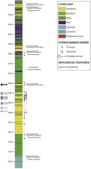
Figure 11.
The 835 m interval of the composite profile of exploratory well 3-RO-4-RJS, from depth of 2395 m to 3230 m (end of well). The occurrence of two intervals of Cretaceous turbidite sandstones of the Carapebus Formation was observed, at the following depths and thicknesses: from 2607 m to 2633 m (26 m thick) and from 2800 m to 3057 m (257 m thick). Several formation pre-tests (with the acronym PT in the profile) were carried out at different depths of the deepest interval of the Carapebus Formation, proving the effectiveness of this formation as a producer of oil and gas. Thick packs of shales of the Ubatuba Formation could be seen over the turbidite sandstones, sealing these reservoirs. This well did not reach the generating shales of the Lagoa Feia Formation, adapted from Ref. [14].
Based on the data evaluated in samples from the Lagoa Feia Formation, the average TOC was 0.64%, with 95% of the data ranging from 0.01% to 6.0% (Figure 12). The analysis of Rock-Eval pyrolysis data for the Campos Basin Rift Sequence allowed the identification of two main types of kerogens, type I and type II, present in the same formation.
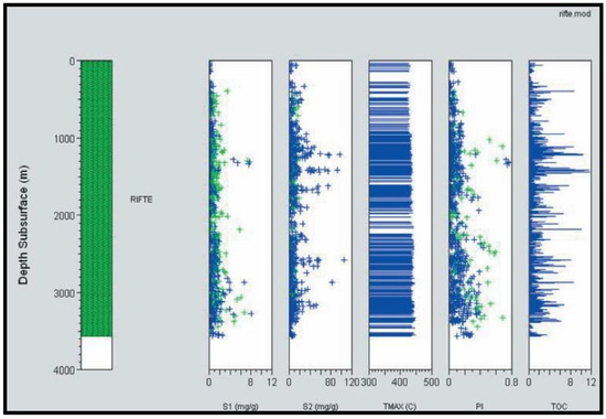
Figure 12.
Geochemical profile of the Lagoa Feia Formation representing the sum of all geo- chemical information regarding this unit [23].
The Maastrichtian turbidite reservoir, the most important reservoir on the Roncador Field, represents a major sand-rich, deepwater system in Campos Basin with large sand volumes in the northeastern, northern and southern portions of the basin. The petrographic analysis indicated, on average, a lithic arkose composition with very low quartz to feldspar ratio (Q/F ¼ 0.65), and medium sand grain size. The sand grains were subangular to sub-rounded, with poor sorting (Figure 13) [15].
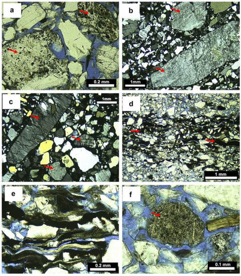
Figure 13.
Photomicrographs of the Maastrichtian reservoir (Well 05) of the Carapebus Formation: photos (a,d,e,f) with uncrossed polarizers; b and c with crossed polarizers. (a) Poorly sorted subangular medium-grained sandstone, lithic arkose; observe the volcanic rock fragments (indicated by red arrows). (b) Very poorly sorted subangular medium-grained sandstone, arkose; observe the pebble-sized feldspar grains (indicated by red arrows). (c) Poorly sorted subangular coarse-grained sandstone, arkose; observe the pebble-size feldspar grains (indicated by red arrows). (d) Moderately sorted subangular fine-grained sandstone, arkose; observe the high content of micaceous grains and of black carbonaceous fragments of burned wood (indicated by red arrows). (e) Detail of the compacted carbonaceous fragments and micas. (f) Moderately sorted subangular fine-grained sandstone, lithic arkose; observe the volcanic rock fragment (indicated by red arrow), adapted from Fetter et al. [15].
The main diagenetic processes identified in the petrographic analysis of the turbidite sandstones of the Carapebus Formation were the formation of pseudomatrix by the compaction of muddy intraclasts, the replacement of intraclasts and pseudomatrix by microcrystalline quartz, cementation by dolomite and calcite, the replacement of feldspars and micas by kaolinite, and sometimes also by calcite. On a smaller scale, feldspar albitization and pyrite precipitation were observed [24].
After analyzing all data from interpreted 2D seismic lines, exploratory wells, source rock geochemistry and petrographic analysis, it was possible to verify that the dynamic processes and the static elements occurred, proving that the Lagoa Feia-Carapebus petroleum system worked.
The source rock probability score (Lagoa Feia Formation) was given based on good average TOC, thickness and average depth (Psr = 0.8). Reservoir rock probability was interpreted due to the very good porosity of the Carapebus Formation turbidites and their excellent permeabilities (Pr = 0.8). The probability of traps was based on the presence of stratigraphic and structural traps and, in addition, to the excellent thickness of the sealing rocks of the Ubatuba Formation (Pt = 0.8). Dynamic probability (timing and migration) was interpreted based on the presence of efficient migration routes (Pd = 0.7). The turbidite reservoirs of the Carapebus Formation (Campos Basin, Brazil) have a qualitative interpretation of low geological risk (Pg = 0.3584).
4.2. Lusitanian Basin (Portugal)–Abadia Formation
For the analysis of the static elements of the petroleum system involving the Abadia Formation at Lusitanian Basin, the following results are presented: interpreted 2D seismic reflection line AR9-80; composite profile of the exploratory well Benfeito-1; geochemical profiles of the source rock of the Cabaços Formation; petrographic analysis of the reservoir rocks of the Abadia Formation with the description of the observed diagenetic processes and calculation of the probability of geological success.
The interpreted 2D seismic reflection line AR9-80 (Figure 14) cuts the Arruda Sub-basin in the NNW-SSE direction. The most evident structure in this seismic line was the Montejunto Anticline (NW of the line), which is related to the diapirism of salt from the Dagorda Formation [25]. The Abadia Formation (Upper Jurassic) presents itself in a wavy wedge shape, with the total thickness (seismic) decreasing towards the Montejunto anticline (NW). Two internal seismic facies were recognized in the Abadia Formation: a lower unit dominated by sandy sediments (possible Cabrito and Castanheira Members—Figure 13), interpreted as potential turbidite reservoir rocks, and an upper interval, formed by prograding marls and siltstones (Upper Member–Margas Abadia), interpreted as potential sealing rocks.
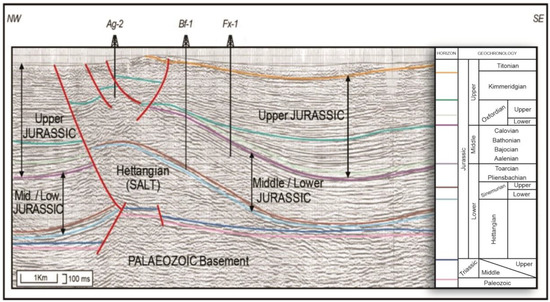
Figure 14.
The 2D AR9-80 seismic reflection line interpreted. The Benfeito-1 (Bf-1) and Freixial-1 (Fx-1) exploratory wells drilled, respectively, 972 m and 1255 m thick in the Abadia Formation, adapted from Rasmussen et al. [26]. The occurrence of listric faults (in red) developed by the salt tectonics of the Dagorda Formation can be observed, which may have enabled the migration of hydrocarbons generated mainly in the Cabaços Formation (beneath the green reflector), and also in the Brenha Formation and the Paleozoic, to the turbidite sandstones of the Abadia Formation (beneath the orange reflector).
According to its composite profile [27], the exploratory well Benfeito-1 (Bf-1), was drilled 972 m thick (from 165 m to 1137 m in depth) in the Abadia Formation lithologies, and 247 m thick in the turbidite sandstones of the Cabrito Member, in which several gas shows were detected (Figure 15), attesting to the Cabaços-Abadia petroleum system. At the top of the Abadia Formation section, thick layers of claystones, marls and siltstones could be observed, sometimes with thin layers of terrigenous sandstones. This package extends from the top of the Abadia Formation, at 165 m depth, to the top of the Cabritos Member, at 890 m depth, totaling 725 m in thickness, being interpreted as belonging to the Upper Member of the Abadia Formation, being the potential sealing rock. From 890 m to 1137 m (247 m thick) there was a predominance of potential reservoirs of sandstones from the Cabrito Member. Several gas shows were detected in the sandstones of the Cabrito Member (Figure 14), proving the occurrence of the Cabaços-Abadia petroleum system.
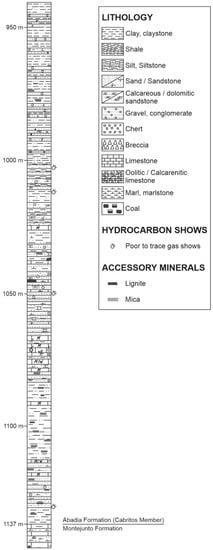
Figure 15.
The 204 m interval (from 940 m to 1144 m depth) of the composite profile of the Benfeito-1 (Bf-1) exploratory well. This range clearly shows various levels of turbidite sandstones from the Cabritos Member. Several hydrocarbon shows were detected in these sandstones, including four at this interval, attesting to the effectiveness of the Cabaços-Abadia petroleum system, adapted from Ref. [27].
The data obtained from outcrops in the Cabaços Formation showed TOC values ranging from 0% to 3.29% (Figure 16a), with the highest values distributed in the Central Sector in the zone of Runa, Turcifal, Arruda and Bombarral sub-basins and in the Serra de Montejunto [28,29,30]. In the North Sector of the basin, the highest values were found in the Figueira da Foz region, at the Cabo Mondego outcrop. Vitrinite reflectance (Ro) values ranged from 0.25% to 1.37% (Figure 16b), with the highest values located mainly in the Lourinhã region, reaching maturation according to the oil window. The maximum values of Ro varied from 0.57% to 1.37%, with the highest values located in the Central Sector, namely in the Bombarral region [28].
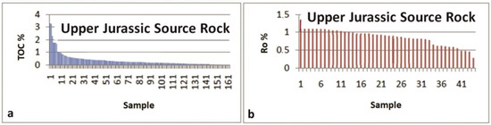
Figure 16.
Total organic carbon (TOC %) (a) and vitrinite reflectance (Ro%) data (b), respectively, from the source rocks of the Cabaços or Vale Verde Formations, adapted from Pena dos Reis and Pimentel [30].
The sandstones of the Abadia Formation analyzed from core sample thin sections from the Benfeito-1 and Freixial-1 exploratory wells corresponded predominantly to lithic arkosium, and secondarily to arkosium. Regarding the diagenetic processes observed in drillhole samples from the Abadia Formation, mechanical compaction on the framework constituents and the precipitation of carbonates (calcite) (Figure 17) by dissolution and nucleation in the hybrid sandstones stood out [31].
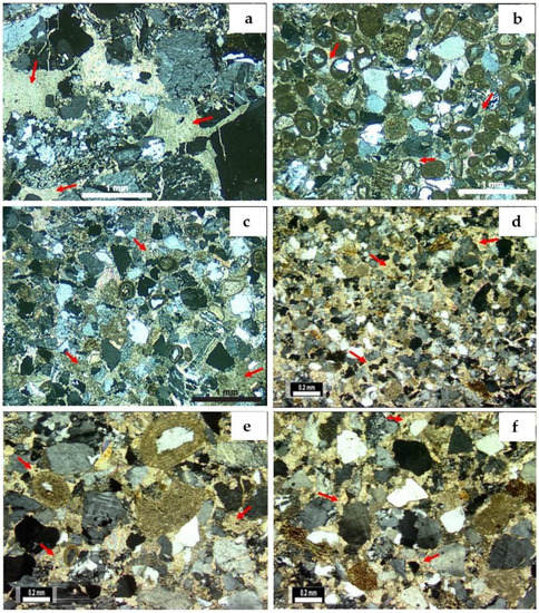
Figure 17.
Photomicrographs with crossed polarizers of core samples of the turbidite sandstone reservoirs (Cabrito Member) of Benfeito-1 exploratory well: (a) 895 m to 900 m depth—very coarse sandstone with fractured grains. Poikilotopic calcite (indicated by red arrows) filling intergranular and grain fracture pores. Intense grain replacement. (b) At 950 m to 955 m depth—hybrid medium sandstone rich in ooids intensely cemented by calcite (indicated by red arrows). (c) At 980 to 985 m depth—hybrid medium sandstone with subangular grains heavily cemented by calcite (indicated by red arrows). Note the partial replacement of grains by calcite. (Photomicrographs with crossed polarizers of core samples of the turbidite sandstone reservoirs (Cabrito Member) of Freixial-1 exploratory well: (d) fine sandstone, poorly sorted, cemented by mosaic calcite (indicated by red arrows) and poikilotopic. (e) Poorly sorted hybrid feldspathic sandstone, rich in ooids, intensely cemented by mosaic calcite (indicated by red arrows) and poikilotopic. (f) Poorly sorted sandstone with subangular grains, cemented by calcite in mosaics (indicated by red arrows), adapted from Garcia et al. [31].
After analyzing all data from interpreted 2D seismic lines, exploratory wells, source rock geochemistry and thin sections, it was possible to verify that the dynamic processes and the static elements occurred, proving that the Cabaços-Abadia petroleum system was successful, even with small amounts of gas detected in the potential turbidite reservoirs of the Abadia Formation across the Lusitanian Basin.
The source rock probability score (Cabaços Formation) was given due to the good average TOC, thickness and average depth (Psr = 0.7). The reservoir rock probability was interpreted based on the low porosity of the turbidites of the Abadia Formation, with a strong action of diagenetic processes (Pr = 0.4). The probability of traps was calculated due to the presence of stratigraphic and structural traps and, in addition, to the good thickness of the sealing rocks of the Upper Member of the Abadia Formation and the evaporites of the Dagorda Formation (Pt = 0.7). The dynamic probability (timing and migration) was interpreted based on the presence of migration routes that carried the hydrocarbons both towards the reservoir rocks and towards the surface (Pd = 0.4). The turbidite reservoirs of the Abadia Formation (Lusitanian Basin, Portugal) have a qualitative interpretation of high to very high geological hazard (Pg = 0.0784).
5. Discussion
Here, the analysis of the efficiency of the static and dynamic elements, timing and economic aspects (Table 1) is presented, in addition to the illustrative schemes for the static and dynamic elements of the two petroleum systems considered. These served as the basis for the analysis of the two studied reservoirs.

Table 1.
Analysis of the efficiency of the static and dynamic elements, timing and economic aspects of the proven petroleum systems.
It should be noted that the results presented in this work address both the static and dynamic elements of the studied petroleum systems, as well as the factors and processes acting on them. This work follows the same concepts and arguments of other works on analogous petroleum systems, which have highlighted the importance of the most likely elements of a play, and which can contribute to the generation, expulsion, migration and trapping of hydrocarbons [32]. Other authors have highlighted the relevance of integrating geology, geophysics and geochemistry (the G3 approach), which can provide powerful inferences about the main elements and processes of the petroleum system [33].
The analysis of analogous reservoirs has been widely used for the evaluation of exploratory plays [34,35,36,37]. In this context, in recent decades several authors have demonstrated the importance of this type of analysis. The study of conjugate margins on Cretaceous turbidite analogues occurring in Equatorial Africa and the northeastern coast of South America [38] has presented a great variety of analyzed data (stratigraphic and structural sections, geochemical data and seismic interpretation of the analyzed reservoirs). On the other hand, the study of petroleum systems analogous to the Lusitanian Basin [39] in basins located on the European continent also presents a good diversity of comparative geological data. However, in the present work, a methodology is proposed based on the classic concepts of the studies of petroleum systems, and their static and dynamic elements, considering their synchronism relations.
5.1. Petroleum System Analysis and the Potential of the Turbiditic Reservoirs–Carapebus Formation–Campos Basin (Brazil)
The source rock static element of the Lagoa Feia Formation (SE1) (Figure 18) has a significant average thickness (100 to 300 m) and occurs at an average depth of 4478 m (Table 1). It entered the oil generation window, as verified by geochemical analyses of kerogen types I and II (oil) and vitrinite reflectance of 0.6%, in the diagenesis to catagenesis range, and average TOC of 0.64% (average), reaching up to 6% (excellent) (Figure 11). Based on these geochemical results, it was possible to verify that the overload, the sedimentary column and the geothermal gradient were the relevant factors of the dynamic elements that most contributed to the success of the source rocks of the Lagoa Feia Formation in the Campos Basin, in terms of generation potential.
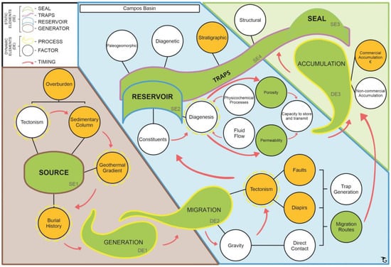
Figure 18.
Illustrative scheme of the analysis of the static and dynamic elements in the study of the Carapebus Formation’s reservoir in the Campos Basin. Legend: Elements, factors and processes that were successful, in green; factors and processes that were relevant in the formation of the petroleum system, in orange; and factors and processes that were not relevant in the formation of the petroleum system, in white.
In regards to the dynamic elements generation (DE1) and migration (DE2) (Figure 17), it could be seen that both were successful in Campo de Roncador, and the relevant factors that most contributed to this good result were the presence of the large faults observed in the rift and drift phases, associated with the walls of the saline domes of the Retiro Formation, which allowed the connection of the generators of the Lower Cretaceous (Barremian-Aptian) Lagoa Feia Formation with the turbidite sandstones reservoirs of the Carapebus Formation, making possible the formation of efficient migration routes, as can also be seen in the interpreted seismic section (Figure 10).
Regarding the static reservoir element (SE2) (Figure 18), it was verified that the turbidite sandstones of the Carapebus Formation have good to very good porosity (from 19% to 29%) and very good to excellent permeability (263 mD to 2560 mD) [40]. The main diagenetic processes (dynamic elements) observed in the petrographic analysis of turbidite sandstones of the Carapebus Formation (classified as lithic arkose to arkose and lithic subarkosea) were the formation of pseudomatrix by the compaction of muddy intraclasts, the replacement of intraclasts and pseudomatrix by quartz micro-crystalline, cementation by dolomite and calcite, and the replacement of feldspars and micas by kaolinite, and sometimes by calcite. Such diagenetic processes were observed locally in areas where the porosity of these sandstones was completely obliterated by carbonate cementation [41].
Concerning the formation of traps (SE4) (Figure 18), these were mainly stratigraphic, and the lobular bodies of the turbidite sandstones associated with submarine fans were effectively encapsulated and sealed by the shales and marls of the Ubatuba Formation (SE3), due to the deposition of turbidites in irregular areas, associated with local shallow zones caused by halokinesis [42]. The salt tectonics provided the mechanism for the formation of traps, as well as the paths for the migration of oil to higher stratigraphic levels through the windows in the evaporitic sequence [43] and also by the large faults developed by this tectonic, as can be seen in the interpreted seismic line presented (Figure 10). Other traps observed in these reservoirs were structural and combined or mixed, including wedging of sandy bodies against the wall of saline domes and diapirs (pinch-outs), anticlines (4-way closure), failed anticlines (3-way closure), and “turtle shell” structures, all induced by salt tectonics. The success of the formation of these traps was also due to the adequate timing of hydrocarbon migration and trapping, associated with salt tectonics, allowing the formation of commercial accumulations of oil and gas in these lobular turbidite bodies of the Roncador Field.
5.2. Petroleum System Analysis and the Potential of the Turbiditic Reservoirs–Abadia Formation–Lusitanian Basin (Portugal)
The static source rock element of the Cabaços Formation (SE1) (Figure 19), has an average thickness of 200 m (up to 385 m in the Campelos-1 exploratory well) and occurs at an average depth of 1906 m. It was found that the source rocks of the Cabaços Formation entered the oil and wet gas generation window, as confirmed by geochemical analysis of kerogen types I, II and III (oil and gas), vitrinite reflectance of 0.57% to 1.37% (Figure 16b) from catagenesis to metagenesis, with maturation reaching the wet oil and gas window and an average TOC of 2% to 5% (Figure 16a). Based on the geochemical results achieved, it was possible to certify that the relevant factors of the dynamic elements that contributed most to the success of the source rocks of the Cabaços Formation in the Lusitanian Basin were the geothermal gradient and the burial history.
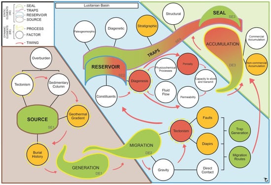
Figure 19.
Illustrative scheme of the analysis of the static and dynamic elements in the study of the Abadia Formation’s reservoir in the Lusitanian Basin. Legend: Elements, factors and processes that were successful, in green; elements, factors and processes that have not been successful, in red; factors and processes that were relevant in the formation of the petroleum system, in orange; and factors and processes that were not relevant in the formation of the petroleum system, in white.
In regards to the dynamic elements generation (DE1) and migration (DE2) (Figure 18), the occurrence of several gas shows in the turbidite sandstones of the Cabrito Member from the Abadia Formation in the Benfeito-1 wells (Figure 14) and Freixial-1, shows that these elements worked, however inefficiently, to generate an economic accumulation of hydrocarbons. The migration of hydrocarbons may have been caused by the listric fault system generated by the diapirism of the evaporites of the Dagorda Formation in the Serra de Montejunto region, visible in the AR-90 2D seismic line (Figure 13), which may have provided the formation of migration routes, for the hydrocarbons generated in the Cabaços Formation (Upper Jurassic), and also in the Brenha Formation and in the Paleozoic, for the turbidite sandstones (potential reservoir) of the Cabrito and Castanheira Members of the Abadia Formation.
Regarding the reservoir static element (SE2) (Figure 19), it was found that the turbidite sandstones of the Cabrito Member of the Abadia Formation are medium-grained, opaque to brownish, with clayey cement, sometimes friable, interspersed with levels of gray silty clay and oolitic limestones (grainstone–packstone) with poor porosity, from 8% to 9%, noted on the final drilling report of the Freixial-1 exploratory well [27]. Based on the analysis and description of petrographic thin sections [31], it was found that the poorly selected sandstones of the Cabrito Member show dissolution of feldspar grains and other silicates, with intense replacement of these by carbonates (calcite). The cementation of the matrix observed in the thin sections was by mosaic calcite and poikilotopic (Figure 17). Texture relations between the diagenetic constituents and the framework demonstrate that the cementation of the matrix by calcite was post-mechanical and chemical compaction, and post-generation of kaolinite and titanium minerals, as it occurred by replacing these diagenetic constituents.
The main forms of traps (SE4) (Figure 19) for the potential reservoirs of the Cabrito and Castanheira Members of the Abadia Formation are stratigraphic, with the “Abadia Marls” of the Upper Member and the Marls of the Tojeira Member of this formation acting as main sealants (SE3) for the lobes of the turbidite sandstones. Other situations of potential trap for these turbidite sandstones are the evaporitic deposits of the Dagorda Formation as sealants, which due to their plasticity can generate stratigraphic and structural traps over all potential reservoirs in the basin. Other potential sealants are the silty or sandy marls from Sobral Formation.
The reasons why the stratigraphic and structural traps in the prospects that drilled the sandstones of the Cabrito and Castanheira Members of the Abadia Formation have not yet discovered commercial accumulations of hydrocarbons can be related as follows:
- The petrographic thin sections described for the sandstones of the Cabrito Member (Figure 17) attest that they were subjected to strong diagenetic processes of substitution of grains from their matrix and their replacement by calcite in mosaics and poikilotopic, after mechanical and chemical compaction, which radically reduced its porosity;
- The diapiric structures of the Dagorda Formation, observed in the central portion of the Lusitanian Basin, in the seismic line presented (Figure 14) and in the exploratory wells studied (Benfeito-1 and Freixial-1), may have been responsible for the subvertical migration of hydrocarbons along faults related to these diapirs, or along their walls. However, some of the diapiric structures were exhumed. This fact led to the destruction of part of the structures that had stored the oil; and
- Compression features, such as anticlines and thrust systems, related to Alpine Inversion (late Cretaceous), in addition to contemporary fractures, may be responsible for having destroyed the integrity of traps and allowing the escape of stored hydrocarbons towards overlapping formations and to the surface in the form of exudations.
6. Conclusions
The methodology employed in this work successfully evaluated analogous reservoir formations, deposited in the same depositional environment, in Atlantic rift and passive margin basins in Brazil and Portugal. A multiscale characterization of the static and dynamic elements of petroleum systems (general objective) was carried out to prove that the petroleum systems were successful in each case studied. The analysis of both petroleum systems (specific objective) was carried out with the goal of reporting the main differences in the static and dynamic elements of the studied petroleum systems and their active factors and processes, which placed similar reservoir formations in a situation of exploratory success or failure.
Being a study that analyzed analogous formations, the genesis of the investigated basins had be taken into account, considering that the units deposited in the context of basins of the passive margin type in the South Atlantic had greater depositional space than in the Lusitanian Basin in Portugal.
The processes of migration and accumulation of hydrocarbons in the Campos Basin were closely linked to the dynamics of the evaporitic sequence which, due to very low permeability, acted as an important conditioner for the flow of hydrocarbons generated in the rift section, and evaporites can act both as retainers as carriers. In the Campos Basin, salt diapirs and the associated large faults provided the formation of excellent migration routes for the hydrocarbons generated in the rift and transitional sections to reach the reservoirs of Cretaceous turbidite lobes of the Carapebus Formation, as can be seen in this case study.
Regarding the static elements, the source rock of the Lagoa Feia Formation has an excellent average thickness of 200 m, average TOC from regular to good (0.64% to 6%), and an average depth of 4478 m. The turbidite sandstones of the Carapebus Formation have an average porosity of 19% to 29% (good to very good) and excellent permeabilities (up to 2650 mD). The sealing shales of the Ubatuba Formation reach an average thickness of 1114 m. The presence of stratigraphic and structural traps and synchronism are also relevant factors for the success of the petroleum system and the economic viability of the accumulation. All the analyzed factors led to the calculation of the probability of geological success in the low risk range (Pg = 0.3584).
The presented methodology sought to elucidate the possible reasons for the economic failure, so far, of the prospects defined and drilled in the potential analogue turbidite reservoirs of the Abadia Formation, in the Lusitanian Basin. In these potential reservoirs a strong action of diagenetic processes was found (mainly pore cementation by calcite and post-mechanical and chemical compactions) that radically reduced their porosities (2% to 9%, insignificant to poor). The medium depth of these reservoirs is 284 m (Well Fx-1), in a medium depth of 802.5 m. Despite being considered a shallow reservoir, several hydrocarbons shows were detected in these sandstones. The intense influence of the salt tectonics of the Dagorda Formation may have been responsible for the subvertical migration of hydrocarbons along faults related to these diapirs, or along their walls. However, these diapiric structures from the Dagorda Formation have been exhumed. This exhumation together with the compression features related to alpine inversion and contemporary fractures may be responsible for having destroyed the integrity of traps and allowing the escape of stored hydrocarbons towards overlapping formations and to the surface, in the form of exudations. The Abadia Formation reservoirs were classified as high to very high risk, based on the calculation of the probability of geological success (Pg = 0.0784).
The potential of the Lusitanian Basin in terms of hydrocarbons is real and is not exhausted. The knowledge we have about this basin is the result of a strong exploratory effort from the 1950s to the 2010s, when several prospects were tested. However, it is necessary to continue these works, with the execution of new geophysical prospections (potential methods and seismic reflection lines) and exploratory drillings in structures not yet tested. These exploratory works could help in the identification of hydrocarbon reservoirs still trapped by the salt diapirs of the Dagorda Formation in the subsurface.
The analysis of the petroleum systems present in turbidite reservoirs in the combined shores of the Atlantic allowed a better understanding of the factors and processes responsible for their efficiency. Through the identification and classification of static and dynamic elements, according to the methodology presented in this work, it was possible to carry out an analysis of the studied petroleum systems in a clearer and more critical way. The multiscale analysis of the processes and products that define each type of reservoir becomes essential as a contribution to the definition of the classification of the probability of the geological success of a reservoir. In this context, the multiscale analysis of all elements of both units studied allowed us to understand why the turbidite reservoirs of the Carapebus Formation have a better probability of geological success than those of the Abadia Formation. Permo-porosity and seal efficiency are the main features of this analysis.
Author Contributions
Conceptualization, G.S.B., R.P.d.R., A.J.V.G., G.d.A.B. and G.G.G.; methodology, G.S.B., A.J.V.G. and G.G.G.; validation, G.S.B., A.J.V.G. and G.G.G.; investigation, G.S.B., R.P.d.R., A.J.V.G., G.d.A.B. and G.G.G.; writing—original draft preparation, G.S.B.; writing—review and editing, G.S.B., R.P.d.R., A.J.V.G., G.d.A.B. and G.G.G.; visualization, G.S.B., R.P.d.R., A.J.V.G., G.d.A.B. and G.G.G.; supervision, R.P.d.R., A.J.V.G., G.d.A.B. and G.G.G. All authors have read and agreed to the published version of the manuscript.
Funding
The geologist Gustavo Santana Barbosa was funded by the Postgraduate Training Program of ANP. This research was funded by Portuguese funds by Fundação para a Ciência e a Tecnologia, I.P. (Portugal), grant number UIDB/00073/2020 and UIDP/00073/2020, projects of I & D unit Geosciences Center (CGEO).
Data Availability Statement
The data used in this research were provided by the Directorate-General for Energy and Geology (DGEG—https://www.dgeg.gov.pt/, accessed on 29 September 2022) and by The Brazilian National Agency of Petroleum, Natural Gas and Biofuels (ANP—https://www.gov.br/anp/pt-br/assuntos/exploracao-e-producao-de-oleo-e-gas/dados-tecnicos/dados-tecnicos, accessed on 29 September 2022). The remaining data were obtained from the works described in the bibliographic references.
Acknowledgments
The authors are grateful to André Cortesão and Ana Fainstein for the English review. The authors are grateful to the Maria Helena Henriques (University of Coimbra, Portugal), to Patrícia João, and CGEO students, for supporting this research. The authors are deeply grateful to the reviewers for the careful revision of the manuscript.
Conflicts of Interest
The authors declare no conflict of interest. The funders had no role in the design of the study; in the collection, analyses, or interpretation of data; in the writing of the manuscript, or in the decision to publish the results.
References and Notes
- Zhang, G.; Qu, H.; Chen, G.; Zhao, C.; Zhang, F.; Yang, H.; Zhao, Z.; Ma, M. Giant discoveries of oil and gas fields in global deepwaters in the past 40 years and the prospect of exploration. J. Nat. Gas Geosci. 2019, 4, 1–28. [Google Scholar] [CrossRef]
- Magoon, L.B.; Dow, W.G. Memoir 60: The Petroleum System—From Source to Trap, The Petroleum System: Chapter 1: Part I. Introduction; AAPG: Tulsa, OK, USA, 1994. [Google Scholar]
- Garcia, A.J.V.; Rocha, L.M.; Chagas, A.L.S. A Bacia Sergipe-Alagoas—Potencial Exploratório em Hidrocarbonetos na Sub-Bacia de Sergipe; Relatório MME-CODISE: Brasília, Brazil, 2009; 19p. [Google Scholar]
- Perrodon, A.; Masse, P. Subsidence, sedimentation and petroleum systems. J. Pet. Geol. 1984, 7, 5–26. [Google Scholar] [CrossRef]
- Bastos, G. Presentation of the Technical Seminar of the 13th Brazilian Bidding Round, Campos Basin, National Agency of Petroleum, Natural Gas and Biofuels (ANP). 2015. Available online: https://www.gov.br/anp/pt-br/rodadas-anp/rodadas-concluidas/concessao-de-blocos-exploratorios/13a-rodada-licitacoes-blocos/seminarios (accessed on 13 March 2019).
- Pena Dos Reis, R.; Pimentel, N. Lusitanian Basin Evolution and Petroleum Systems Analysis Field-Trip Guide. ISBN: 978-989-96923-6-7. Available online: https://meg.ipn.pt/field-trip-guides/ (accessed on 29 September 2022).
- Portella, A.Y. Presentation of the Technical Seminar of the Fifteenth Bidding Round made in 30 January 2018, Campos Basin, National Agency of Petroleum, Natural Gas and Biofuels (ANP). 2018. Available online: http://www.anp.gov.br/images/Palestras/Seminario_tecnico_R15_P4/Ingles/04_Bacia_de_Campos_R15_INGLES.pdf (accessed on 17 June 2021).
- Alves, M.A.R. Presentation of the Technical Seminar of the Ninth Bidding Round, Campos Basin, Superintendence of Blocks Definition, National Agency of Petroleum, Natural Gas and Biofuels (ANP). 2007. Available online: http://rodadas.anp.gov.br/arquivos/Round9/palestras/Campos(portugues).pdf (accessed on 12 March 2019).
- Silva, R.L.; Mendonça Filho, J.G.; Azeredo, A.C.; Duarte, L.V. Palynofacies and TOC analysis of marine and non-marine sediments across the Middle-Upper Jurassic boundary in the central-northern Lusitanian Basin (Portugal). Facies 2014, 60, 255–276. [Google Scholar] [CrossRef]
- Spigolon, A.L.D.; Pena dos Reis, R.P.B.; Pimentel, N.L.; Matos, V.G.A.E. Geoquímica orgânica de rochas potencialmente geradoras de petróleo no contexto evolutivo da Bacia Lusitânica, Portugal. Bol. Geociênc. Petrobras 2011, 19, 131–162. [Google Scholar]
- Pimentel, N.L.; Pena Dos Reis, R. Petroleum Systems of the West Iberian Margin: A Review of the Lusitanian Basin and the Deep Offshore Peniche Basin. J. Pet. Geol. 2016, 39, 305–326. [Google Scholar] [CrossRef]
- Pena Dos Reis, R.; Pimentel, N.; Garcia, A.; Bueno, G. (Eds.) Curso de Campo na Bacia Lusitânica (Portugal); Instituto Pedro Nunes, Petrobras e Fundação da Faculdade de Ciência da Universidade de Lisboa: Coimbra, Portugal, 2007; 153p. [Google Scholar]
- Furlan, L.M. Caracterização Sísmica de Aspectos Tectono-Estratigráficos da Região do Campo de Roncador (Cretáceo Superior)—Bacia de Campos—Brasil; Trabalho de Conclusão de Curso; Universidade Estadual Paulista Júlio de Mesquita Filho (UNESP): São Paulo, Brazil, 2017; 65p. [Google Scholar]
- BDEP/ANP. Banco de Dados de Exploração e Produção (BDEP)—Agência Nacional do Petróleo, Gás Natural e Biocombustíveis (ANP)—Data from 49 Exploratory Wells of the Campos, Santos and Recôncavo Basins Basins, Received by the Capacity Program of Employees of ANP. Available online: https://www.gov.br/anp/pt-br/assuntos/exploracao-e-producao-de-oleo-e-gas/dados-tecnicos/dados-tecnicos (accessed on 19 April 2019).
- Fetter, M.; De Ros, L.F.; Bruhn, C.H. Petrographic and seismic evidence for the depositional setting of giant turbidite reservoirs and the paleogeographic evolution of Campos Basin, offshore Brazil. Mar. Pet. Geol. 2009, 26, 824–853. [Google Scholar] [CrossRef]
- DGEG—DIREÇÃO GERAL DE ENERGIA E GEOLOGIA. DGEG Website—Location Map of 2D Seismic Lines and Exploration Wells of the Lusitanic Basin. 2021. Available online: https://geoapps.dgeg.gov.pt/sigdgeg/ (accessed on 15 April 2021).
- Garcia, A.J.V.; Pereira, F.C.; Araújo, W.B.; Rocha, L.M.; Ribeiro, D.D.M.; Leal, F.P.M.; Correia, G.L. Caracterização Multiescalar de Reservatórios Carbonáticos Análogos em Afloramentos da Bacia de Sergipe-Alagoas, NE do Brasil; Boletim Técnico da Petrobras; Neto, O.C.P., Ed.; Petrobras: Rio de Janeiro, Brazil, 2014; Volume 22, pp. 51–82. [Google Scholar]
- Garcia, A.J.V.; Ribeiro, D.D.M.; Figueiredo SAS, T.; Dantas, M.V.S.; Oliveira, I.C.; Santos, K.A.L.; Garcia, G.G. 3D Modeling of Carbonate Reservoir Analogue Outcrops Using Camures Methodology, Sergipe-Alagoas Basin (SEAL), NE, Brazil. AAPG Annual Convention & Exhibition, Denver. ACE. 2015. Available online: http://www.Searchanddiscovery.com/documents/2015/41631vasconcellos/ndx_vasconcellos.pdf (accessed on 8 February 2018).
- Otis, R.M.; Schneidermann, N. A process for evaluating exploration prospects. AAPG Bull. 1997, 81, 1087–1109. [Google Scholar]
- Lucena, B.R.D.; Lustosa, L.J. Abordagem Bayesiana para Avaliação do Risco Geológico na Exploração de Petróleo e Gás. In Proceedings of the XXVII Encontro Nacional de Engenharia de Produção (ENEGEP), Foz do Iguaçu, Brazil, 9–11 October 2007. 9p. [Google Scholar]
- Rose, P.R. Risk Analysis and Management of Exploration Ventures; AAPG Methods in Exploration Series, No. 12; APPG: Tulsa, OK, USA, 2001; 165p. [Google Scholar]
- Furlan, L.M.; Vincentelli, M.G.C. Geophysical analysis of the tectonic-stratigraphic aspects of Roncador Field—Campos Basin. In Proceedings of the Fifteenth International Congress of the Brazilian Geophysical Society, Rio de Janeiro, Brazil, 31 July–3 August 2017. 6p. [Google Scholar]
- ANP/UNESP/LEBAC. Interpretação e Mapeamento dos Sistemas Petrolíferos da Bacia de Campos—Tomos 1, 2 e 3. Relatório Final do BDEP Para Estudos de Capacitação2006. 226 p.
- Costa, C.Z. Sedimentologia e Petrologia dos Depósitos Turbidíticos do Cretáceo Superior da área do Campo de Peregrino, Bacia de Campos, RJ. Graduate Thesis. Instituto de Geociências da Universidade Federal do Rio Grande do Sul. 2012; 85p.
- Silva, L.T. A Formação Abadia no Contexto Evolutivo-Tectono-Sedimentar da Bacia Lusitânica (Portugal)—Considerações Sobre o Potencial como Rocha Reservatório de Hidrocarbonetos. Master’s Thesis, Universidade Federal do Rio Grande do Sul, Porto Alegre, Brazil, 2003; 123p. [Google Scholar]
- Rasmussen, E.S.; Lomholt, S.; Andersen, C.; Vejbaek, O.V. Aspects of the structural evolution of the Lusitanian basin in Portugal and the shelf and slope area offshore Portugal. Tectonophysics 1998, 300, 199–255. [Google Scholar] [CrossRef]
- DGEG—DIREÇÃO GERAL DE ENERGIA E GEOLOGIA. Data from 27 exploration wells of the Lusitanian Basin. Received in external HD in 7 October 2020.
- BEICIP-FRANLAB. Geochemical evaluation of the Lusitanian and Porto Basins. Gab. Pesq. Explor. Petróleo, Lisboa. Unpubl. Report, 9 Vols. 1996.
- Dias, A.J.G. Reavaliação do Potencial Petrolífero do Onshore da Bacia Lusitânica, Portugal. Ph.D. Thesis, Departamento de Geologia, Faculdade de Ciências, Universidade do Porto, Porto, Portugal, 2005. [Google Scholar]
- Pena Dos Reis, R.; Pimentel, N.L. Sistemas Petrolíferos no On-Shore da Bacia Lusitânica—Uma Visão Geológica Integradora. 2012. Available online: https://www.researchgate.net/publication/260276683_Os_sistemas_petrolíferos_na_Bacia_Lusitanica/download (accessed on 13 September 2021).
- Garcia, A.J.V.; Pimentel, N.; Pena Dos Reis, R. 4º Relatório Técnico Semestral—Partes 1, 2 e 3—“Caracterização Petrológica de Intervalos Potencialmente Reservatórios da Bacia Lusitânica, com foco no Jurássico”. Equipe executora: GARCIA, A., PEREIRA, F., ARMELENTI, G. Projeto ATLANTIS—Petrobras/FAPESE/IPN/FFCUL/UFS/UC/UL. 2009; 450p.
- Huvaz, O. Comparative petroleum systems analysis of the interior basins of Turkey: Implications for petroleum potential. Mar. Pet. Geol. 2009, 26, 1656–1676. [Google Scholar] [CrossRef]
- Dickson, W.; Schiefelbein, C.; Zumberge, J.; Odegard, M. Basin Analysis and West Conjugates: Combining Disciplines to desconstruct petroleum systems. In Proceedings of the GCSSEPM Foundation 25th Annual Bob F. Perkins Research Conference, Houston, TX, USA, 4–7 December 2005; 12p. [Google Scholar]
- Love, F. Contrasting Structural Styles, Brazilian and West African South Atlantic Volcanic and Nonvolcanic Margins: The Impact on Presalt Petroleum Systems. In Sedimentary Basins: Origin, Depositional Histories, and Petroleum Systems; Pindell, J., Horn, B., Rosen, N., Weimer, P., Dinkleman, M., Lowrie, A., Fillon, R., Granath, J., Kennan, L., Eds.; SEPM Society for Sedimentary Geology: Tulsa, OK, USA, 2014; Volume 33, pp. 1–28. [Google Scholar] [CrossRef]
- Alves, T.; Fetter, M.; Busby, C.; Gontijo, R.; Cunha, T.A.; Mattos, N.H. A tectono-stratigraphic review of continental breakup on intraplate continental margins and its impact on resultant hydrocarbon systems. Mar. Pet. Geol. 2020, 117, 104341. [Google Scholar] [CrossRef]
- Mellho, M.R.; Azambuja Filho, N.C.; Bender, A.A.; Barbanti, S.M.; Mohriak, W.; Schmitt, P.; De Jesus, C.L.C. The Namibian and Brazilian southern South Atlantic petroleum systems: Are they comparable analogues? In Conjugate Divergent Margins; Mohriak, W.U., Danforth, A., Post, P.J., Brown, D.E., Tari, G.C., Nemčok, M., Sinha, S.T., Eds.; Geological Society: London, UK, 2012; Volume 369, pp. 249–266. [Google Scholar] [CrossRef]
- Schiefelbein, C.F.; Zumberge, J.E.; Cameron, N.C.; Brown, S.W. Geochemical comparison of crude oil along the South Atlantic margins. In Petroleum Systems of South Atlantic Margins; Mello, M.R., Katz, B.J., Eds.; AAPG Memoir: Tulsa, OK, USA, 2000; Volume 73, pp. 15–26. [Google Scholar] [CrossRef]
- Kelly, J.; Doust, H. Exploration for Late Cretaceous turbidites in the Equatorial African and northeast South American margins. Neth. J. Geosci. 2016, 95, 393–403. [Google Scholar] [CrossRef]
- Dragos, C. An anologue study of sedimentary systems: West Iberian Basins vs. East European Basins. In Proceedings of the 2018 AAPG Europe Regional Conference, “Global Analogues of the Atlantic Margin”, Lisbon, Portugal, 2–3 May 2018. [Google Scholar]
- ANP E&P Application. Official Data on Exploration Contracts, Exploratory Blocks, Declarations of Commerciality, Production Fields, Exploratory Wells and E&P Companies. 2020.
- Bruhn, C.H.L.; Gomes, J.A.T.; Lucchese, C.D., Jr.; Johann, P.R.S. Campos Basin: Reservoir Characterization and Management—Historical Overwiew and Future Challenges. In Proceedings of the OTC 15220 Offshore Technology Conference, Houston, TX, USA, 5–8 May 2003; 14p. [Google Scholar]
- Guardado, L.R.; Gamboa, L.A.P.; Lucchesi, C.F. Petroleum Geology of the Campos Basin, Brazil: A Model for a producing Atlantic-type basin. In Divergent/Passive Margin Basins; Edwards, J.D., Santogrossi, P.A., Eds.; AAPG Memoir: Tulsa, OK, USA, 1989; Volume 48, pp. 3–79. [Google Scholar]
- Figueiredo, A.M.F.; Mohriak, W.U. A tectônica salífera e as acumulações de petróleo da Bacia de Campos. In Proceedings of the 33º Congresso Brasileiro de Geologia, Rio de Janeiro, Brazil, 21–25 October 1984; Volume 3, pp. 1380–1394. [Google Scholar]


Publisher’s Note: MDPI stays neutral with regard to jurisdictional claims in published maps and institutional affiliations. |
© 2022 by the authors. Licensee MDPI, Basel, Switzerland. This article is an open access article distributed under the terms and conditions of the Creative Commons Attribution (CC BY) license (https://creativecommons.org/licenses/by/4.0/).