


Sustainable Development Efficiency of Cultural Landscape Heritage in Urban Fringe Based on GIS-DEA-MI, a Case Study of Wuhan, China


Abstract

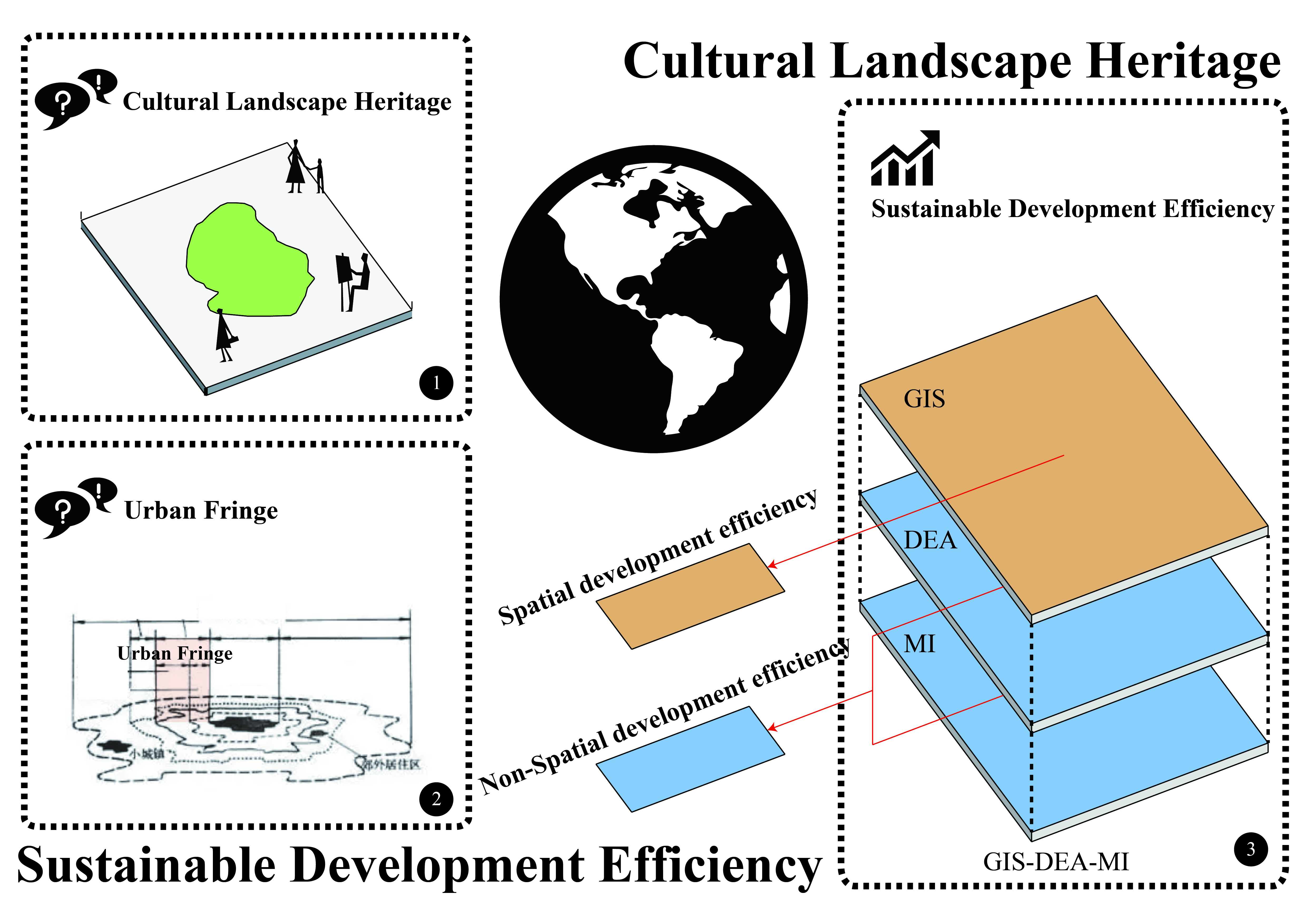
1. Introduction
2. Materials and Methods
3. Empirical Research
3.1. Research on Spatial Efficiency
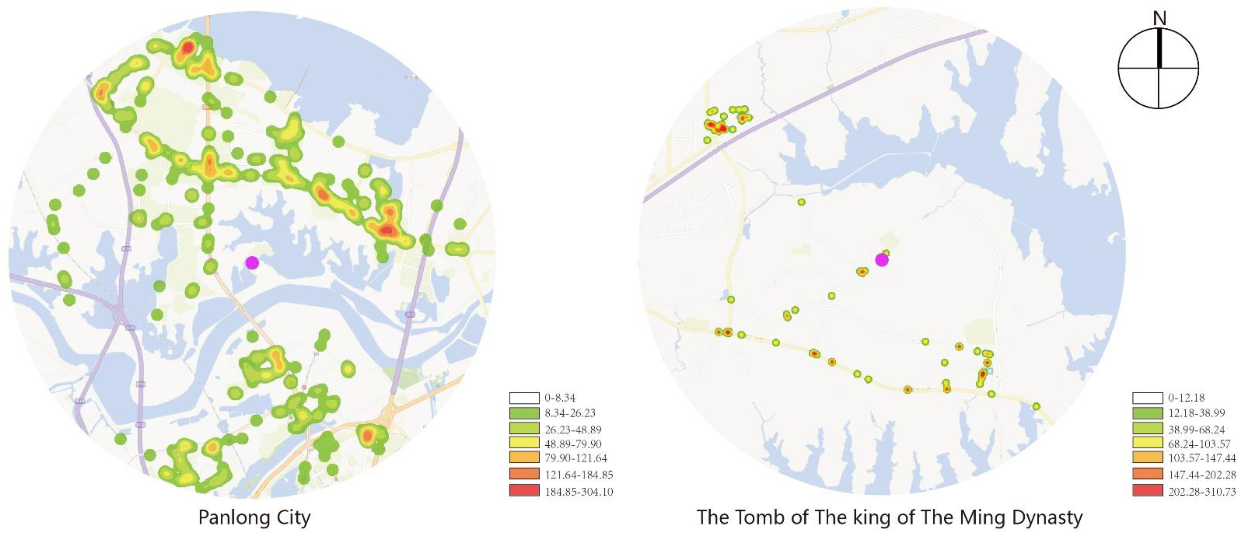
3.1.1. Analysis of POI Data and Kernel Density Calculation
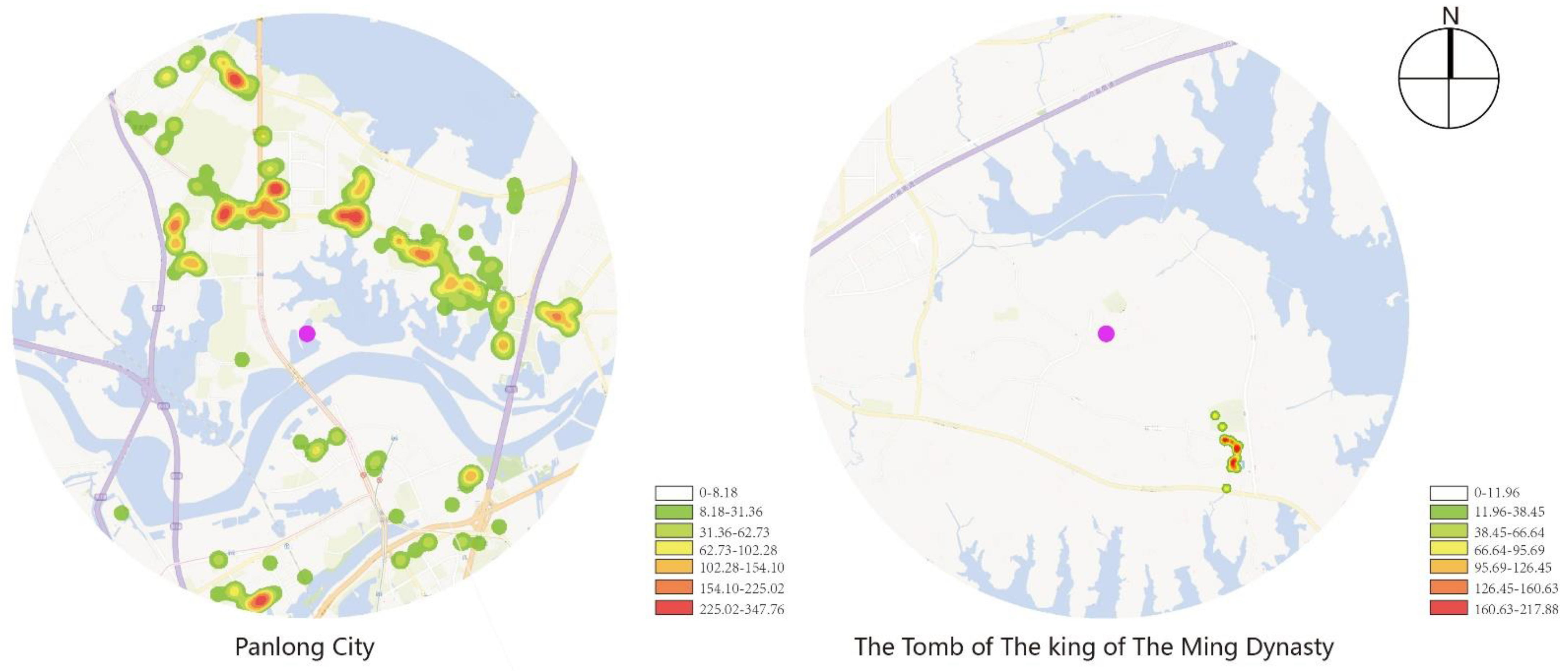
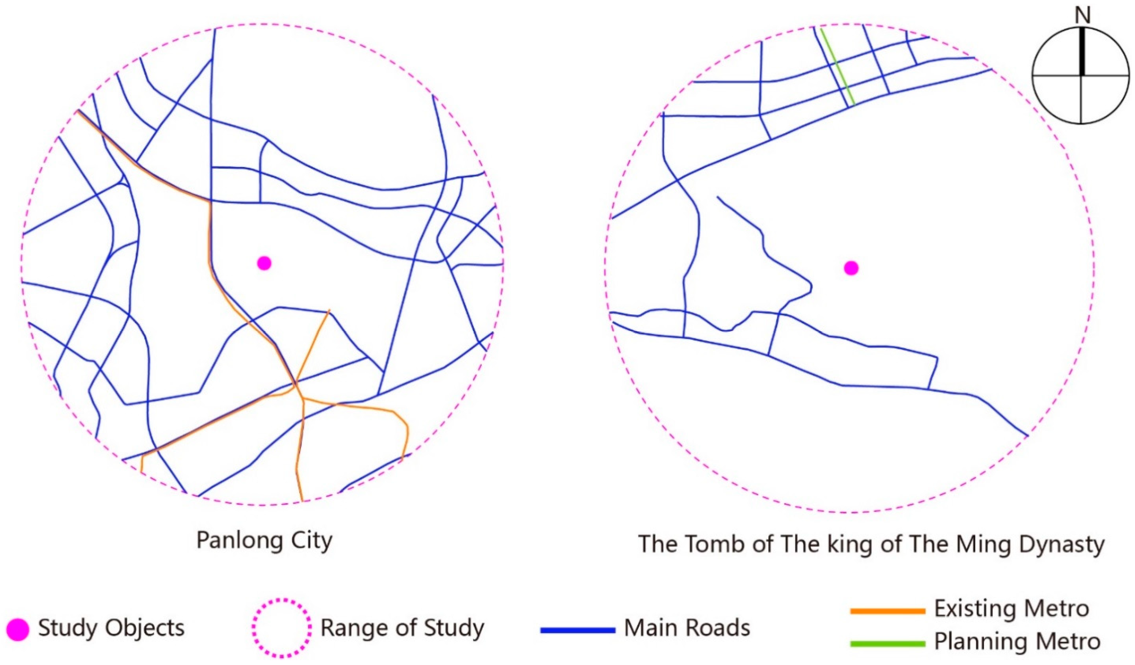
3.1.2. Analysis of the Road Network
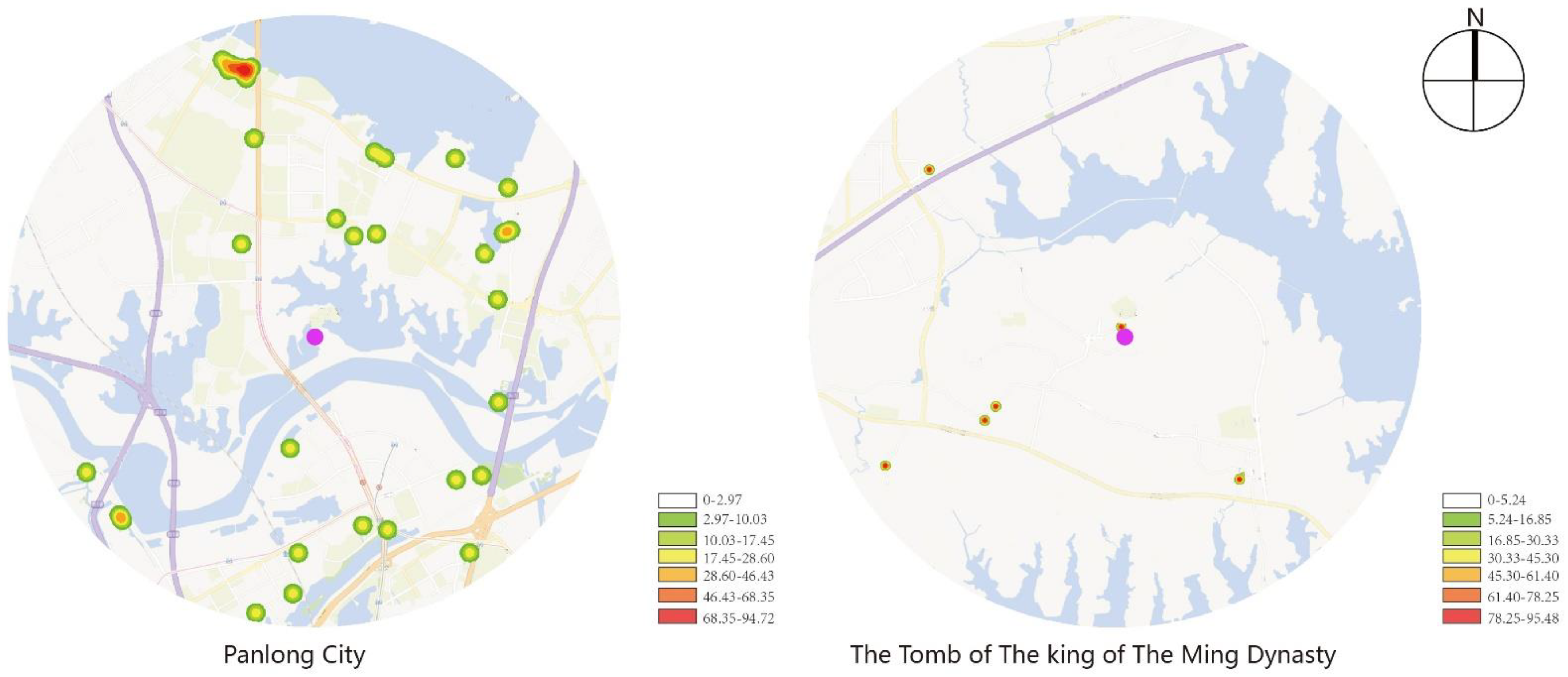
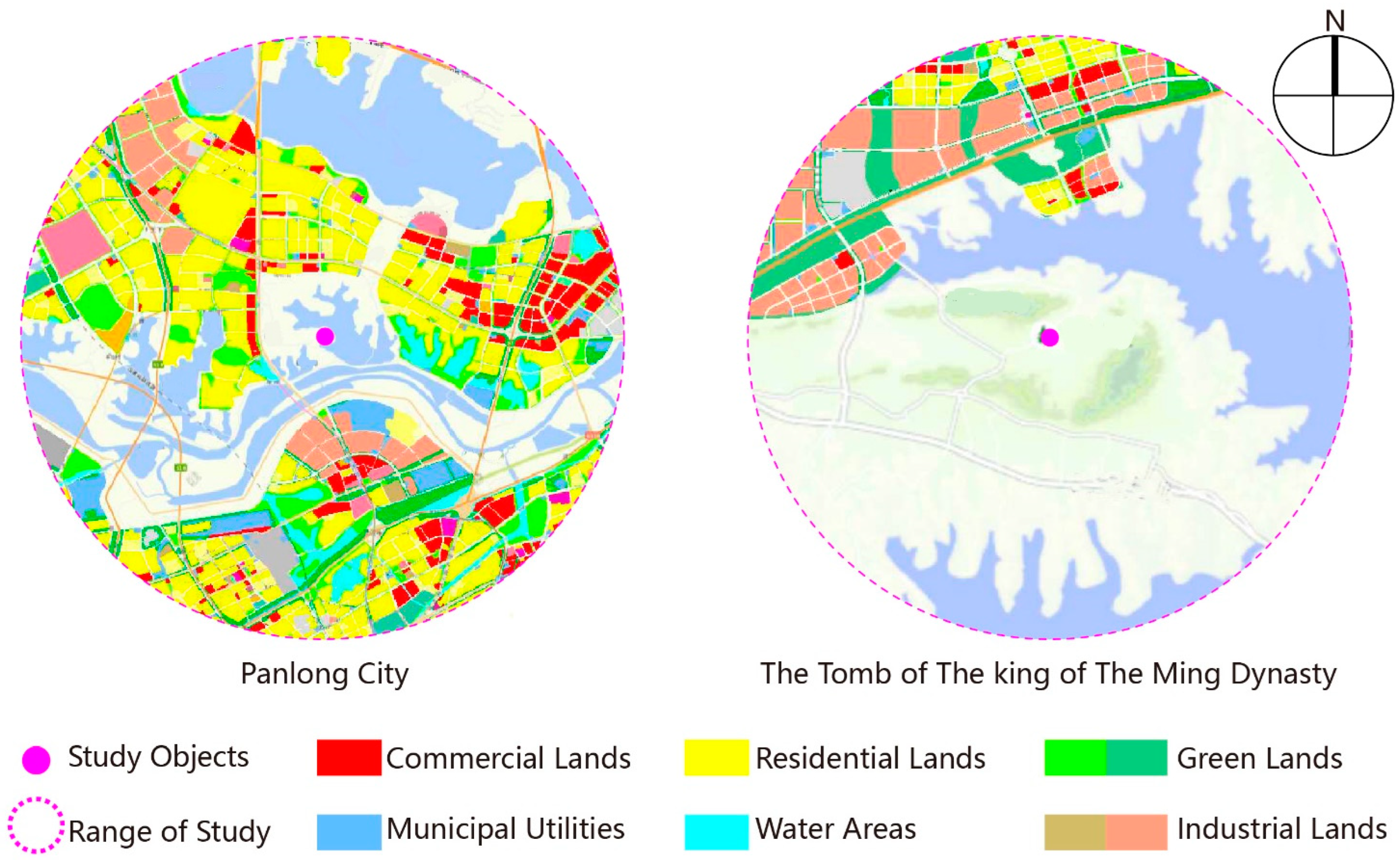
3.1.3. Analysis of Land Use Property
3.2. Research on Non-Spatial Efficiency
3.2.1. The Selection of the Index
3.2.2. Data Analysis
4. Conclusions
- Seen from spatial development efficiency, Panlongcheng has a much higher core density of POI data than the Tomb of the King of the Ming Dynasty, and the quantity and density of its road network are also superior than the latter’s. Hence, more effort should be put into the construction of the Tomb’s surrounding basic facilities. As for the type of land use, Panlongcheng has more varied types of its surrounding land use, which has been involved in Wuhan’s urban-rural land use planning, while the surrounding land types of the Tomb are mostly ecological agriculture and forestry, with the obvious advantage of natural resources. Consequently, future work of urban planning and cultural landscape heritage preservation and utilization should stress the improvement of the Tomb’s surrounding land use planning and the protection of its environmental integrality, so as to facilitate its sustainable and green development with its advantage in natural resources.
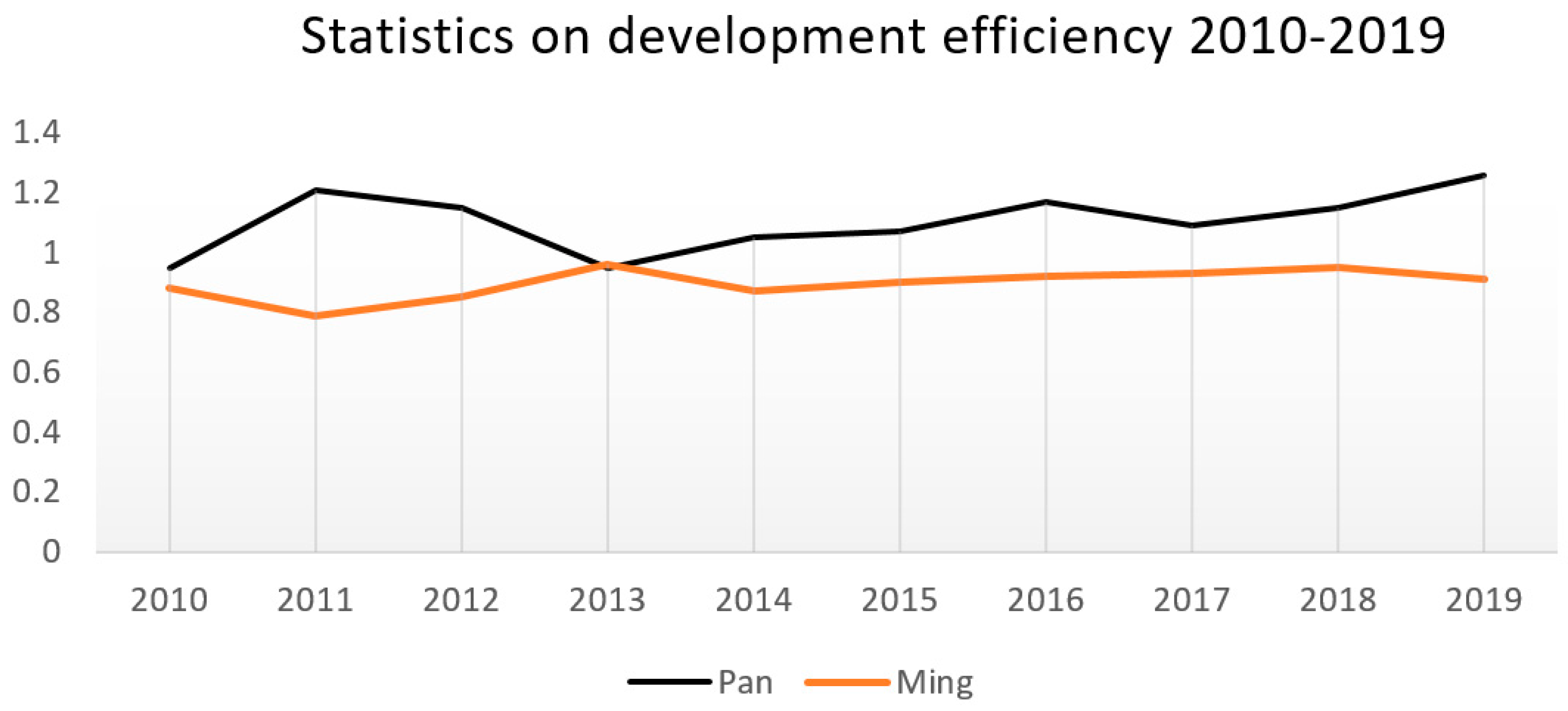
- The non-spatial development efficiency of the two parks from 2010 to 2019 had small fluctuations, but that of the archaeological park of the Tomb of the King of the Ming Dynasty was low in general. As a national archaeological park with much better policy support, investment and human resources, Panlongcheng Archaeological Park enjoyed higher non-spatial development efficiency than the Tomb. As a result, the improvement of the Tomb’s non-spatial development efficiency should be achieved by digging deep into its cultural value, actively developing its protection and declaration of the world’s cultural heritage, and seeking stronger support in policy, fund, and manpower.
- The application of the GIS-DEA-MI model in research on the development efficiency of archaeological site parks in urban fringes is appropriate both in the early planning of construction and in the post-assessment stage. The study of the early planning can decide reasonable input and optimize the investment efficiency, while the post-assessment stage helps to improve resource allocation. Local government can make macroscopic adjustments according to the dynamic variation data of tourism efficiency to promote the development efficiency of archaeological parks in urban fringe and the harmonious development of urban and rural areas.
- 4.
- Research on spatial development efficiency still has room for a systematic study combining the theory of national land planning;
- 5.
- Research on non-spatial development still lacks common and widely accepted standards for the selection of output indexes and input indexes.
Author Contributions
Funding
Institutional Review Board Statement
Informed Consent Statement
Data Availability Statement
Conflicts of Interest
References
- Jackson, J.B. Discovering the Vernacular Landscape; Yale University Press: New Haven, CT, USA, 1984. [Google Scholar]
- Taylor, K.; Feng, H.; Feng, T. Cultural Landscapes and Asian Values: Negotiating a Transition from an International Experience to an Asian Regional Framework. Chin. Landsc. Archit. 2007, 23, 4–9. (In Chinese) [Google Scholar]
- Li, L. Tradition and Change; Jiangxi People’s Publishing House: Nanchang, China, 2008; p. 8. (In Chinese) [Google Scholar]
- Jixiang, S. From the Cultural Landscape to the Cultural Landscape Heritage (Part One). Southeast Cult. 2010, 2, 7–18. [Google Scholar]
- Jixiang, S. From the Cultural Landscape to the Cultural Landscape Heritage (Part Two). Southeast Cult. 2010, 16, 7–12. [Google Scholar]
- Banzhaf, E.; Anderson, S.; Grandin, G.; Hardiman, R.; Jensen, A.; Jones, L.; Knopp, J.; Levin, G.; Russel, D.; Wu, W.; et al. Urban-Rural Dependencies and Opportunities to Design Nature-Based Solutions for Resilience in Europe and China. Land 2022, 11, 480. [Google Scholar] [CrossRef]
- Jacques, D. The Rise of Cultural Landscapes. Int. J. Herit. Stud. 1995, 1-2, 91–101. [Google Scholar] [CrossRef]
- Hong, Y. Research on Cultural Landscape Conservation in China. Master’s Thesis, Northwest A&F University, Yangling, China, 2009. (In Chinese). [Google Scholar]
- Logan, W.S. Dien Bien Phu: Development and Conservation in a Vietnamese Cultural Landscape. In Proceedings of the Forum UNESCO University and Heritage 10th International Seminar, Newcastle upon Tyne, UK, 11–16 April 2005. [Google Scholar]
- ICOMOS. The World Heritage List: Filling the Gaps—An Action Plan for the Future; ICOMOS: Charenton-le-Pont, France, 2004. [Google Scholar]
- Peter, F. World Heritage Cultural Landscapes, 1992–2002: A Review and Prospect; UNESCO World Heritage Center: Paris, France, 2003. [Google Scholar]
- Taylor, K. Cultural Landscapes and Asia: Reconciling International and Southeast Asian Regional Values. Landsc. Res. 2009, 34, 7–31. [Google Scholar] [CrossRef]
- Taylor, K. From Physical Determinant to Cultural Construct: Shifting discourses in reading landscape as history and ideology. In Proceedings of the Fifteenth Annual Conference of the Society of Architectural Historians Australia and New Zealand, Melbourne, VIC, Australia, 28 September–1 October 1998; University of Melbourne: Melbourne, VIC, Australia, 1998; pp. 371–378. [Google Scholar]
- Han, F. The Chinese View of Nature: Tourism in China’s Scenic and Historic Interest Areas. Ph.D. Thesis, Queensland University of Technology, Brisbane, QLD, Australia, 2006. [Google Scholar]
- Jia, S.; Liao, Y.; Xiao, Y.; Zhang, B.; Meng, X.; Qin, K. Methods of Conserving and Managing Cultural Heritage in Classical Chinese Royal Gardens Based on 3D Digitalization. Sustainability 2022, 14, 4108. [Google Scholar] [CrossRef]
- Wang, X.; Li, J.; Zheng, T.; Diao, S.; Zhang, X.; Tian, Y. Constructing Landscape Ecological Security Patterns of an Ancient Capital Based on Cellular Automata Theory. Urban Sci. 2022, 6, 29. [Google Scholar] [CrossRef]
- Capuano, A. Living Amidst the Ruins in Rome: Archaeological Sites as Hubs for Sustainable Development. Sustainability 2022, 14, 3180. [Google Scholar] [CrossRef]
- Sukwai, J.; Mishima, N.; Srinurak, N. Balancing Cultural Heritage Conservation: Visual Integrity Assessment to Support Change Management in the Buffer Zone of Chiang Mai Historic City Using GIS and Computer-Generated 3D Modeling. Land 2022, 11, 666. [Google Scholar] [CrossRef]
- Kaldun, B. Stakeholder Cooperation in Managing World Heritage Sites: The UNESCO Lijiang Models. In World Tourism Organization Seminar Proceedings, Proceedings of the Sustainable Tourism Managementat World Heritage Sites-Enhancing Inter-Agency and Stakeholder Coordination for Joint Action, Huangshan, China, 24–27 March 2008; World Tourism Organization: Madrid, Spain, 2009; pp. 113–119. [Google Scholar]
- Connell, J.; Page, S.J.; Bentley, T. Towards sustainable tourism planning in New Zealand: Monitoringlocal government planning under the Resource Management Act. Tour. Manag. 2009, 30, 867–877. [Google Scholar] [CrossRef]
- Yasarata, M.; Altinay, L.; Burns, P.; Okumus, F. Politics and sustainable tourism development—Can they co-exist? Voices from North Cyprus. Tour. Manag. 2010, 31, 345–356. [Google Scholar] [CrossRef]
- Zuo, D.; Li, C.; Lin, M.; Chen, P.; Kong, X. Tourism, Residents Agent Practice and Traditional Residential Landscapes at a Cultural Heritage Site: The Case Study of Hongcun Village, China. Sustainability 2022, 14, 4423. [Google Scholar] [CrossRef]
- Carta, M.; Gisotti, M.R.; Lucchesi, F. Settlements and Urban Morphological Quality in Landscape Planning–Analytical Models and Regulating Tools in the Landscape Plan of Regione Toscana. Sustainability 2022, 14, 1851. [Google Scholar] [CrossRef]
- Dong, Q.; Qu, S.; Qin, J.; Yi, D.; Liu, Y.; Zhang, J. A Method to Identify Urban Fringe Area Based on the Industry Density of POI. ISPRS Int. J. Geo-Inf. 2022, 11, 128. [Google Scholar] [CrossRef]
- UN-Habitat. The Value of Sustainable Urbanization; United Nations Human Settlements Programme: Nairobi, Kenya, 2020. [Google Scholar]
- Sumari, N.S.; Xu, G.; Ujoh, F.; Korah, P.I.; Ebohon, O.J.; Lyimo, N.N. A Geospatial Approach to Sustainable Urban Planning: Lessons for Morogoro Municipal Council, Tanzania. Sustainability 2019, 11, 6508. [Google Scholar] [CrossRef]
- Fang, X.C.; Chen, H.; Wang, X.L. Coordination of economic development and ecological environment in resource exhausted cities. Ecol. Econ. 2015, 11, 36–42. [Google Scholar]
- Zheng, Y.; Rashid, H.U.; Siddik, A.B.; Wei, W.; Hossain, S.Z. Corporate Social Responsibility Disclosure and Firm’s Productivity: Evidence from the Banking Industry in Bangladesh. Sustainability 2022, 14, 6237. [Google Scholar] [CrossRef]
- Liu, W.; He, Z.; Chen, H.; Lin, C. Comparative Analysis Chinese Green Buildings’ of Input-Output Effect Based on Data Envelope Analysis. Buildings 2022, 12, 659. [Google Scholar] [CrossRef]
- Zou, W.; Zhang, L.; Xu, J.; Xie, Y.; Chen, H. Spatial-Temporal Evolution Characteristics and Influencing Factors of Industrial Pollution Control Efficiency in China. Sustainability 2022, 14, 5152. [Google Scholar] [CrossRef]
- Tong, L.; Chen, Y.; Jin, L.; Zheng, X. Regional Sustainable Performance of Construction Industry in China from the Perspective of Input and Output: Considering Occupational Safety. Buildings 2022, 12, 618. [Google Scholar] [CrossRef]
- Li, H.; Lin, Y.; Wang, Y.; Liu, J.; Liang, S.; Guo, S.; Qiang, T. Multi-Criteria Analysis of a People-Oriented Urban Pedestrian Road System Using an Integrated Fuzzy AHP and DEA Approach: A Case Study in Harbin, China. Symmetry 2021, 13, 2214. [Google Scholar] [CrossRef]
- Li, D.; Wang, X. Land-Use Change and Efficiency in Laos’ Special Economic Zones. Land 2021, 10, 1012. [Google Scholar] [CrossRef]
- Yin, Q.; Wang, Y.; Wan, K.; Wang, D. Evaluation of Green Transformation Efficiency in Chinese Mineral Resource-Based Cities Based on a Three-Stage DEA Method. Sustainability 2020, 12, 9455. [Google Scholar] [CrossRef]
- Xia, B.; Dong, S.; Ba, D.; Li, Y.; Li, F.; Liu, H.; Li, Z.; Zhao, M. Research on the Spatial Differentiation and Driving Factors of Tourism Enterprises’ Efficiency: Chinese Scenic Spots, Travel Agencies, and Hotels. Sustainability 2018, 10, 901. [Google Scholar] [CrossRef]
- Li, Y.; Liu, A.-C.; Wang, S.-M.; Zhan, Y.; Chen, J.; Hsiao, H.-F. A Study of Total-Factor Energy Efficiency for Regional Sustainable Development in China: An Application of Bootstrapped DEA and Clustering Approach. Energies 2022, 15, 3093. [Google Scholar] [CrossRef]
- Zhu, S.; Zhou, Z.; Li, R.; Li, W. Impact of High-Speed Rail Construction on the Environmental Sustainability of China’s Three Major Urban Agglomerations. Sustainability 2022, 14, 2567. [Google Scholar] [CrossRef]
- Geng, H.; Shi, E.P.; Wang, L.Z.; Xie, R.; Yu, B.J. Evaluation of the Development Efficiency of Small Towns around Metropolis Based on GIS-DEA:Taking Wuhan as an Example. Econ. Geogr. 2018, 38, 72–79. (In Chinese) [Google Scholar]
- Tao, Z.L.; Chen, G.Y. Research progress of the two-step floating catchment area method and extensions. Prog. Geogr. 2016, 35, 589–599. (In Chinese) [Google Scholar]
- Liu, S.; Yang, Y.; Jia, H. Research on Service Radius and Influencing Factors of Community Parks in Shanghai Based on Mobile Phone Signaling Data. Landsc. Archit. 2021, 28, 88–93. (In Chinese) [Google Scholar] [CrossRef]
- Yang, Y.Y.; Zhang, Y.; Zeng, D.Y.; Cheng, S. Spatial and temporal characteristics of tourism efficiency in Hainan Province based on DEA-MI model. Tour. Overv. 2019, 14, 157–158+160. (In Chinese) [Google Scholar]
- Guo, T.Y.; Dong, G.P. Study on the Relationships between Metropolitan Spatial Compact Rations and Their Efficiencies in China in 1990 and 2000. J. Geo-Inf. Sci. 2009, 11, 482–490. (In Chinese) [Google Scholar]
- Fang, X.C.; Chen, H.; Wang, X.L. Evaluation of tourism efficiency in resource-exhausted cities based on DEA-MI Model. Stat. Decis. 2015, 7, 55–57. [Google Scholar] [CrossRef]
- Sheng, Y.C.; Liu, Q. Spatial Difference of Human Capital Promoting Regional Tourism Economic Efficiency: Empirical Re-search Based on “Hu Line”. Sci. Geogr. Sin. 2020, 40, 1710–1719. [Google Scholar] [CrossRef]


| Evaluation Index | Quantitative Criteria | Units |
|---|---|---|
| Total income from tourism | Annual tourism revenue of the administrative region | CNY 100 million |
| Total tourist arrivals | Annual tourism reception of the administrative region | Person-time |
| Industrial structure | Proportion of tertiary industry | percentage |
| Public service input | Annual total input of public utilities in the administrative region | CNY 100 million |
| Human capital input | Total number of tertiary industry employees | Person |
| 2010 | 2011 | 2012 | 2013 | 2014 | 2015 | 2016 | 2017 | 2018 | 2019 | Mean Value | |
|---|---|---|---|---|---|---|---|---|---|---|---|
| Pan | 0.95 | 1.21 | 1.15 | 0.95 | 1.05 | 1.07 | 1.17 | 1.09 | 1.15 | 1.26 | 1.21 |
| Ming | 0.88 | 0.79 | 0.85 | 0.96 | 0.87 | 0.90 | 0.92 | 0.93 | 0.95 | 0.91 | 0.89 |
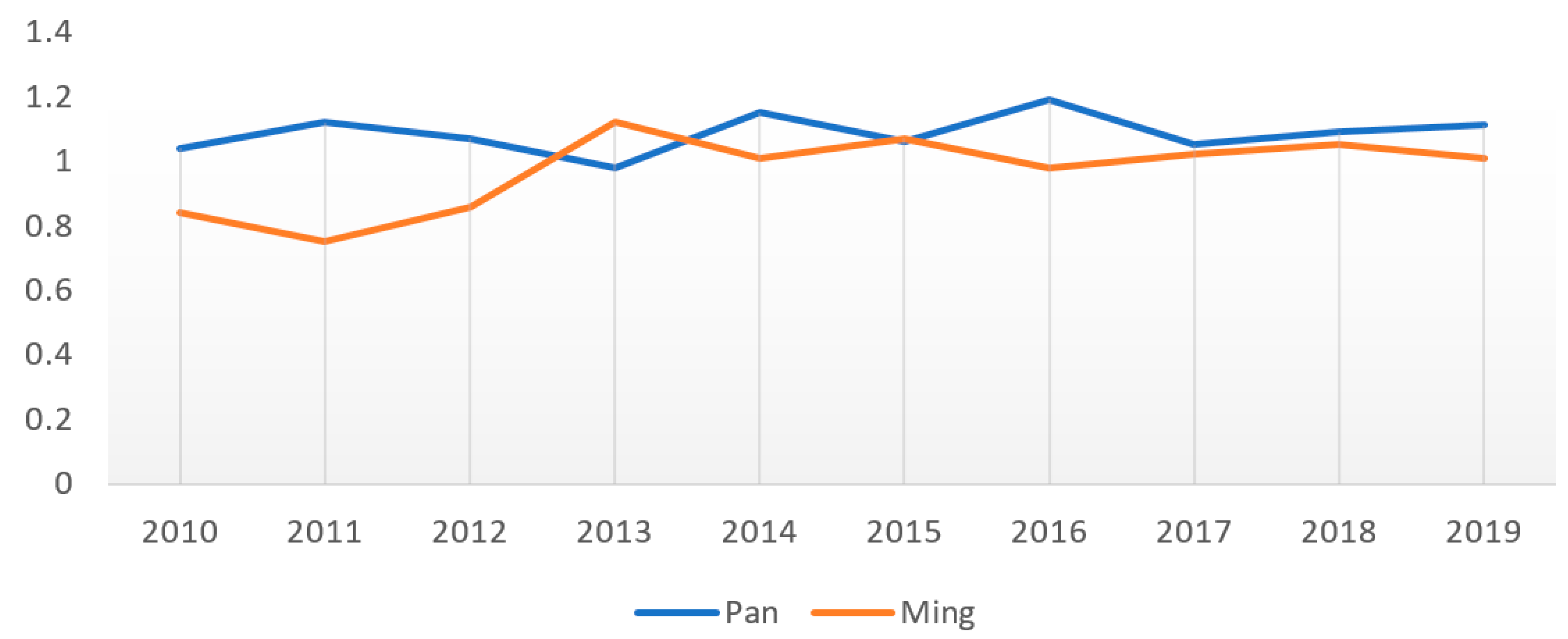
| 2010 | 2011 | 2012 | 2013 | 2014 | 2015 | 2016 | 2017 | 2018 | 2019 | Mean Value | |
|---|---|---|---|---|---|---|---|---|---|---|---|
| Pan | 1.04 | 1.12 | 1.07 | 0.98 | 1.15 | 1.06 | 1.19 | 1.05 | 1.09 | 1.11 | 1.09 |
| Ming | 0.84 | 0.75 | 0.86 | 1.12 | 1.01 | 1.07 | 0.98 | 1.02 | 1.05 | 1.01 | 0.97 |
Publisher’s Note: MDPI stays neutral with regard to jurisdictional claims in published maps and institutional affiliations. |
© 2022 by the authors. Licensee MDPI, Basel, Switzerland. This article is an open access article distributed under the terms and conditions of the Creative Commons Attribution (CC BY) license (https://creativecommons.org/licenses/by/4.0/).
Share and Cite
Zou, H.; Liu, Y.; Li, B.; Luo, W. Sustainable Development Efficiency of Cultural Landscape Heritage in Urban Fringe Based on GIS-DEA-MI, a Case Study of Wuhan, China. Int. J. Environ. Res. Public Health 2022, 19, 13061. https://doi.org/10.3390/ijerph192013061
Zou H, Liu Y, Li B, Luo W. Sustainable Development Efficiency of Cultural Landscape Heritage in Urban Fringe Based on GIS-DEA-MI, a Case Study of Wuhan, China. International Journal of Environmental Research and Public Health. 2022; 19(20):13061. https://doi.org/10.3390/ijerph192013061
Chicago/Turabian StyleZou, Han, Yang Liu, Baihao Li, and Wenjing Luo. 2022. "Sustainable Development Efficiency of Cultural Landscape Heritage in Urban Fringe Based on GIS-DEA-MI, a Case Study of Wuhan, China" International Journal of Environmental Research and Public Health 19, no. 20: 13061. https://doi.org/10.3390/ijerph192013061
APA StyleZou, H., Liu, Y., Li, B., & Luo, W. (2022). Sustainable Development Efficiency of Cultural Landscape Heritage in Urban Fringe Based on GIS-DEA-MI, a Case Study of Wuhan, China. International Journal of Environmental Research and Public Health, 19(20), 13061. https://doi.org/10.3390/ijerph192013061