Article

Assessing Riverbank Erosion and Livelihood Resilience Using Traditional Approaches in Northern Bangladesh

by
Abdullah Al Mamun
1,
Abu Reza Md. Towfiqul Islam
1,*,
Edris Alam
2,3,
Subodh Chandra Pal
4 and
G. M. Monirul Alam
5
1
Department of Disaster Management, Begum Rokeya University, Rangpur 5400, Bangladesh
2
Faculty of Resilience, Rabdan Academy, Abu Dhabi P.O. Box 114646, United Arab Emirates
3
Department of Geography and Environmental Studies, University of Chittagong, Chittagong 4331, Bangladesh
4
Department of Geography, The University of Burdwan, Bardhaman 713104, West Bengal, India
5
Department of Agribusiness, Bangabandhu Sheikh Mujibur Rahman Agricultural University, Gazipur 1706, Bangladesh
*
Author to whom correspondence should be addressed.
Sustainability 2022, 14(4), 2348; https://doi.org/10.3390/su14042348
Submission received: 6 December 2021 / Revised: 14 January 2022 / Accepted: 19 January 2022 / Published: 18 February 2022
(This article belongs to the Section Hazards and Sustainability)

Abstract

:
Bangladesh is a riverine country that is the most climate-change-vulnerable country in the world. Riverbank erosion adversely affects people and their livelihoods by damaging their homesteads, agricultural land, and causing economic, social, and psychological distress over time. Under these criteria, erosion control measures/approaches are vital for protecting erosion and crating livelihoods resilient. This study intends to assess riverbank erosion and livelihood resilience using traditional erosion control approaches by observing and surveying 118 riverine households in Rowmari, northern Bangladesh. The results show that riverbank erosion enormously damages household lands, socio-economic conditions, livelihoods, and resources, resulting in increased vulnerability. About 54.2% of the households utilize traditional approaches known as bundlings and 33.1% use both bundlings + bank vegetation that helps them resist erosion. Traditional erosion management approaches enhance resilience by safeguarding agricultural land, crop fields, production, and homesteads rapidly and sustainably, and by reducing damage to infrastructure, roads, embankments and transportation in the region. A probit model was also employed to explore factors that have influenced traditional erosion approaches. The factors such as age, education, family size, erosion experience, occupation, earning members, and farm size were meaningfully related to taking traditional erosion approaches. It is expected that the outcomes of the present research will help guide governmental agencies and policymakers and contribute to the construction of a sustainable riverbank erosion action framework in Bangladesh and other regions with similar problems.

1. Introduction

Traditional approaches are vital tools for managing disasters through which local people have to alter their lives and livelihoods to adapt to changing environments [1,2]. In the case of riverbank erosion control, the traditional approaches are cost-effective and eco-friendly and provide rapid sustainability. As a country like Bangladesh, engineered erosion control approaches are time-consuming, costly, and local people participate in utilizing them. Therefore, to minimize the enormous loss of livelihoods, properties, and settlements, etc. caused by riverbank erosion, traditional control approaches need to be considered.
Bangladesh is considered the most disaster-prone country in the world and is extremely vulnerable to climate change [2,3,4,5]. Riverbank erosion is becoming more frequent and intense as a result of climate change, resulting in enormous human and monetary losses in the country [5,6,7,8]. About 20 of the 64 districts in the country are inclined to riverbank erosion [5,9,10]. Regardless of government endeavors to lessen riverbank erosion, for the most part through erosion assurance structures along the bank, it remains a serious issue for floodplain households in the country [5]. About 8700 ha of homestead property and cultivable land is lost every year because of riverbank erosion which displaces approximately 200,000 people [5,10]. Moreover, among the 489 Upazilas of Bangladesh, 94 Upazilas were affected by riverbank erosion in 2013, of which (including Rowmari Upazila of Kurigram) were highly susceptible [11]. The local households are the worst victims of riverbank erosion which, contributes to the loss of livelihoods, economic, land, and other natural, physical, human assets, etc. resulting in increased vulnerability to food uncertainty and a condensed capability to lessen poverty [5,9,12,13,14,15]. As a result of their proximity to the river, the households also are more presented to the effect of successive floods and waterlogging which also increases their vulnerability by damaging crops fields, homestead land, and socio-economic condition. Subsequently, riverbank erosion will continually affect livelihoods and agricultural activities due to climate change [2]. Despite the engineered erosion control approaches that control erosion properly and make livelihoods resilient, there has been quite a challenge in implementing them because such approaches are not cost-effective, time-consuming, place dependent, and most local people participate in utilizing them.
Therefore, research on traditional approaches for controlling riverbank erosion is essential for determining priorities for erosion control and livelihood resilience. Understanding traditional erosion control approaches and implementing theme in marginalized areas are critical for assisting riverine households in combating riverbank erosion [16,17]. There are many studies performed on controlling riverbank erosion [18,19,20], displacement, and the socio-economic impacts of riverbank erosion in Bangladesh [6,7,12,14,15,21,22,23,24,25,26,27,28,29,30,31]. In engineered erosion control approaches, many studies indicate different engineered protections such as revetment, boulders, groins, spurs, geo-bag dumping, jute geotextile, wooden pilling, building an embankment, and porcupine systems [18,19,32,33,34]. But almost no study focuses on traditional erosion control approaches for controlling riverbank erosion and livelihood resilience in Bangladesh.
Traditional erosion management measures have been adopted by the local community with natural resources, which have reduced massive loss and protected bank erosion quickly and sustainably, allowing for livelihood resiliency. It is also critical to comprehend the elements that impact households’ decisions to utilize the traditional measure. As a result, the goal of this research is to evaluate riverbank erosion control adoption and livelihood resilience using traditional erosion control approaches.

2. Materials and Methods
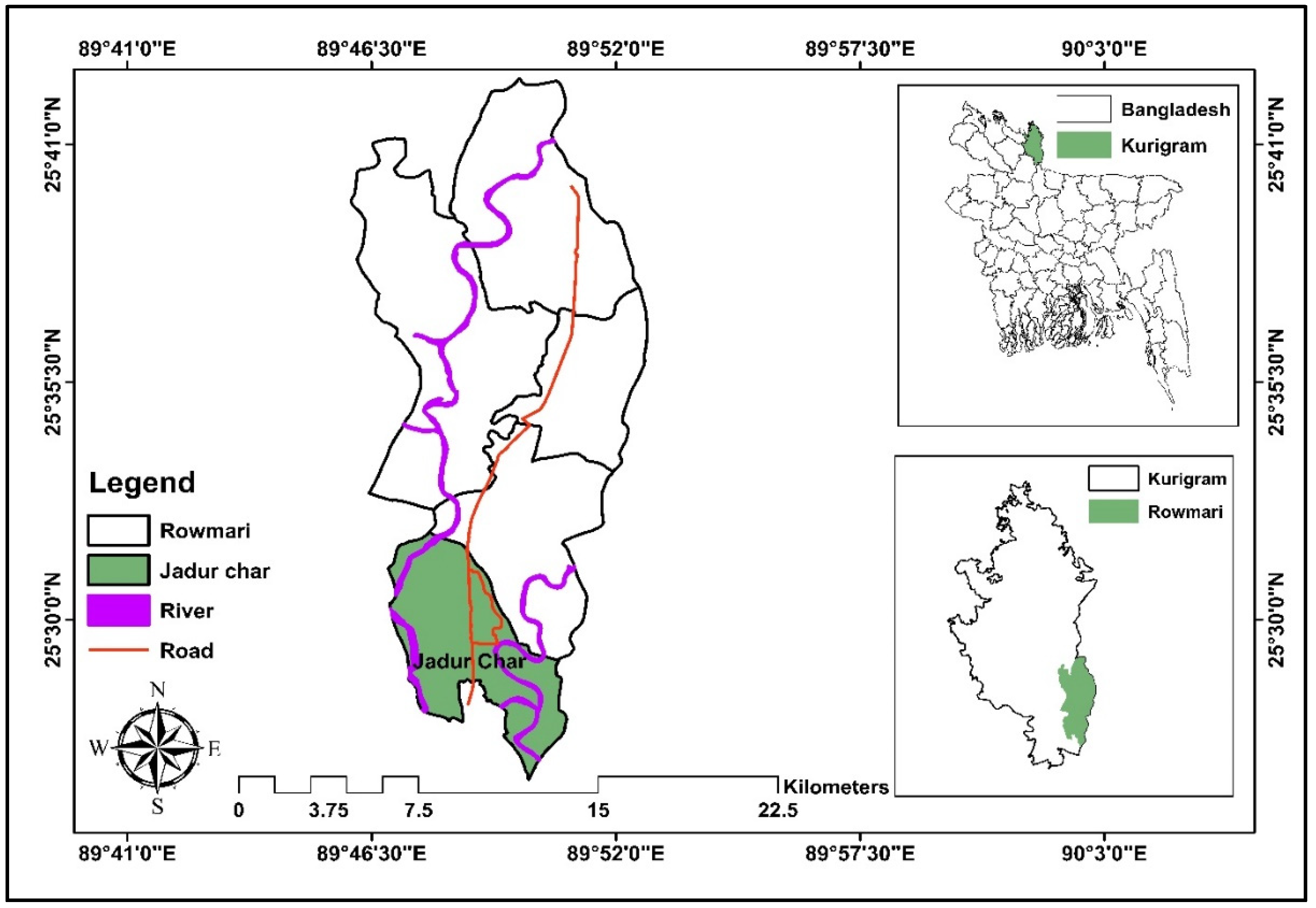
2.1. Study Area

This study was performed at the Jadur Char union in the Raumari Upazila under the Kurigram district of the northern region of Bangladesh. The area is geographically located between 25°30′0″ N and 25°41′0″ N latitude and 89°41′0″ E and 90°3′0″ E longitude (Figure 1). Then, the Bakbanda Nama Para village is selected for data collection considering three aspects (i) this village situated on the bank of the Jhingiram river (ii) and the levels of severity of erosion identified through a review of the reports in newspapers and in consultation with local experts and (iii) the local traditional erosion control measures that reduce erosion in the region. This village is occupied by some 200–250 families, a large portion of whom are impoverished farmers. The Jinjirum, a wandering river beginning on the slopes directly across the border, shapes the destiny of the residents—once in a while by furnishing them with an abundance of fish and alluvial sediment and here and there by immersing the village and obliterating their harvests. In terms of geographical locations, these areas are extremely vulnerable to enormous flooding that led to riverbank erosion. Every year, the monsoon flood and riverbank erosion cause significant damage to people’s lives, property, infrastructure, agriculture, and livestock. A multistage sampling technique was applied to evaluate the traditional approaches to controlling riverbank erosion and livelihood resilience.

2.2. Sample Size Determination

According to the Bangladesh Bureau of Statistics [35], the total number of households for the Bakbanda Nama Para village was 170. Using Cochran’s Formula [36] Equations (1) and (2), the optimum sample size for this village is 118, with a 95% confidence level and 5% margin of error (confidence interval).
n 0 =   Z 2 p q e 2
n = n 0 1 + ( n 0 1 ) N
where
n = Sample size of a given population
n 0 = Sample size for infinitive population
N = Population size
Z = Z value (e.g., 1.96 for 95% confidence level)
p = Percentage estimation as a decimal (0.5 used for sample size required)
q = (1 − p)
e = Confidence interval

2.3. Data Collection and Analysis

Both qualitative and quantitative techniques, including a household questionnaire survey, focus group discussions, and key informant interviews, were employed to collect data for this study. Two focus group discussions (FGDs) and four key informant interviews (KIIs) from the study area were conducted with the local inhabitants on 10 October 2020. A semi-structured household questionnaire survey where the face-to-face survey method was employed from 5 October to 12 November 2020. Respondents were selected randomly, and this technique was also utilizing from top to bottom to explore the real riverbank scenarios and local control approaches in the study region. Before designing a questionnaire sheet, discussion was hold with the local people, and field survey was conducted. Each of the questions followed a chronological linkage to understand the influence of different variables related to riverbank erosion and social vulnerabilities. The questionnaire sheet was divided into five sections: (1) general information about the local people, (2) riverbank erosion threat and impacts, (3) livelihood vulnerability depending on erosion, (4) community traditional approaches for controlling erosion and positive feedback, and (5) factors influencing the taking of traditional control measures. Likert scale (four scales) type questions were used to code the questionnaire data. With regards to the perceived livelihood impacts of riverbank erosion, a respondent’s self-elicitation status was considered: the responses to the questions ranged from high to low impact. In the case of traditional control measures and community resilience, the respondents were asked about utilizing traditional measures of how a community gains resiliency and based on their self-reported it ranged from four classes: no, high, medium, and low.
A total of 118 questionnaires were collected among respondents based on sample size (both male and female) who agreed to share their views. The details questionnaire can be found in the Supplementary Material (S1). All the questions were read to the respondents in the local language. All the information was collected by using feedback forms, and some additional information was recorded by hand and later formatted on a data collection sheet. The questionnaire sought information on the impact of riverbank erosion on livelihoods, infrastructure, agriculture, etc., and the perceptions of changes in extreme events, and response strategies for control. In the case of erosion control, the respondents will be asked about their range of local practices. The traditional approach based on the experience and knowledge of the community is referred to as an individual level controlling approach and the strategy supported technically and financially by government organizations and non-government organizations (NGOs) is referred to as a planned controlling approach. Interviews are conducted with local businessmen, farmers, fishermen, day laborers, housewives, and some other unspecified people. Field observation is performed to understand the erosion and control of research questions. Secondary data was collected from different sources according to the requirements of the study. Different kinds of data like the population of the area, past data on flooding and river erosion, settlement patterns of the respondents, etc. were collected from Bangladesh Bureau of Statistics (BBS), Bangladesh water Development Board (BWDB), union parishad office, etc. Besides, supporting data and related materials were collected from different sources, like the internet, previous research, and survey reports. These findings are helpful in verifying the questionnaire results. The entire approach to data collection was implemented rigorously to maintain the importance of the study’s findings and to fulfill the research goals. Statistical analyses such as descriptive analysis of the local communities, riverbank erosion threat, the livelihood vulnerability based on erosion, traditional approaches and their feedback were conducted for a meaningful presentation of the results, as well as a Chi-square test was performed to validate the probable relationship between different variables in our study. All statistical analyses were performed using SPSS (version 24.0), MS Excel (2016), and ArcGIS 10.7.1. Finally, the analyzed data has been integrated and presented accordingly.

2.4. Probit Model

By using the Probit model, we aimed to investigate the determinants affecting traditional control approaches that make livelihood resilient, where traditional control approaches of households were taken as a binary based on the responses about whether traditional control approaches make livelihood resilient or not. The Probit model is a binary-based numerical probability model in the dependent variable [37]. A probit model analysis is conducted based on the cumulative normal probability distribution. The binary dependent variable was taken on the values of 0 and 1 [38].
In our study, traditional control approaches that make livelihood resilient were considered as dependent variables. and the independent variables were picked from different socio-economic determinants. It was recognized that gender, marital status, family size, farm size, monthly income, access to credit, etc. are usually used in recent studies [39,40,41,42].
For statistical analysis, multicollinearity test was conducted among independent variables [43], where the Variance Inflation Factor (VIF) lies between 1–10. Hence there is no multicollinearity problem found among the independent variables. We used the probit model since the data were cross-sectional [44]; dependent variables were binary and independent variables were both continuous and dummy (Peng et al., 2002). The variables of this model are presented in Table 1. The goodness of model fit was tested with Hosmer-Lameshow test. The probit model is
Y i = α i + X i β i + ε i
where Y i is a dependent variable, Y i , represents traditional erosion control approaches make livelihood resilient, where Y i = 1 if traditional control approaches make livelihoods resilient, and Y i = 0 otherwise. X i is the 1 × K vector of the socio-economic factors that affect the traditional erosion control approaches which makes livelihood resilient, β i is the K × 1 vector of undefined parameters, and ε i is the error term.

3. Results and Discussions

The outcomes of the study are presented into two segments: the first segment represents the demographic characteristics and impacts of riverbank erosion and second segment represents traditional erosion control approaches to control erosion and livelihood resilient.

3.1. Demographic and Farm Characteristics

The demographic and farm characteristics of the respondents are shown in Table 2. According to data in the Table, majority of the respondents (44.9%) were between the ages of 31 and 45. The mean age of the respondents is around 47.95-year-old. Education is the primary basic need of a human being, which can support their whole development. But the results found that most of the respondents (61%) are illiterate, while 20.3% have a primary education and 8% have a graduation level education. The mean family size of 5.0 is similar to the national mean of 5.0 [45]. The outcome shows that (47.5%) of the households have a small family size, while (31.4%) have a medium family size. The majority of the respondents (72%) had one earning member while (18.6%) and (9.3%) had two or three earning members. The respondent’s farm size was comparatively low since most of the respondents had experienced the loss of land due to erosion. The mean farm size is around 0.62 acres. Therefore, the respondent’s farm size is categorized as: large farm size (1.7%) (>2.5 acres), medium farm size (5.1%) (1.5–2.49 acres), small farm size (28.8%) (1.49–0.6 acres), and landless (64.4%) (0.5 acres). The respondent’s occupation groups are categorized based on the main income source (i.e., >50%) (Table 2). Most of the households (74.6%) in the study area are mainly dependent on agriculture, which is comparatively larger than national statistics [46]. The majority (61%) of the households were in the high-income level, where (16.1%) and (12.7%) are upper-middle and lower-middle levels comparatively. The mean annual income of the households was 792.88 USD. The households in the area faced an enormous loss in their socio-economic and livelihood assets.
The results revealed that most households (78.8%) have directly faced erosion impacts on their socio-economic and livelihoods, while (21.2%) experience it as a witness. Road and transport services are not sufficient in the region. The households generally use vans, rickshaws, bicycles, small boats, and tempo to bazaar their products.

3.2. Impacts of Riverbank Erosion

In our study, the impacts of riverbank erosion have classified into two groups i.e., (Section 3.2.1) socio-economic impacts and (Section 3.2.2) households’ perception about impacts of erosion on livelihoods.

3.2.1. Socio-Economic Impacts of Riverbank Erosion

Almost the majority of people believe that riverbank erosion is a natural wonder, but in many circumstances, people also perceive erosion to be the “will of God”. Currently, erosion seems to be one of the main factors in our national poverty [6,24]. Every year, riverbank erosion takes away thousands of hectares of land, while it is the scarcest resource [6,47]. The economic impacts of erosion are the loss of agricultural land which leads to decreasing productivity and consequently declining agricultural income. In recent years, the amount of economic loss and distress experienced by people have increased, which is projected to be approximately USD 500 million a year. The consequence of land loss also includes the loss of homestead which appear to be the victims most affected by land loss.

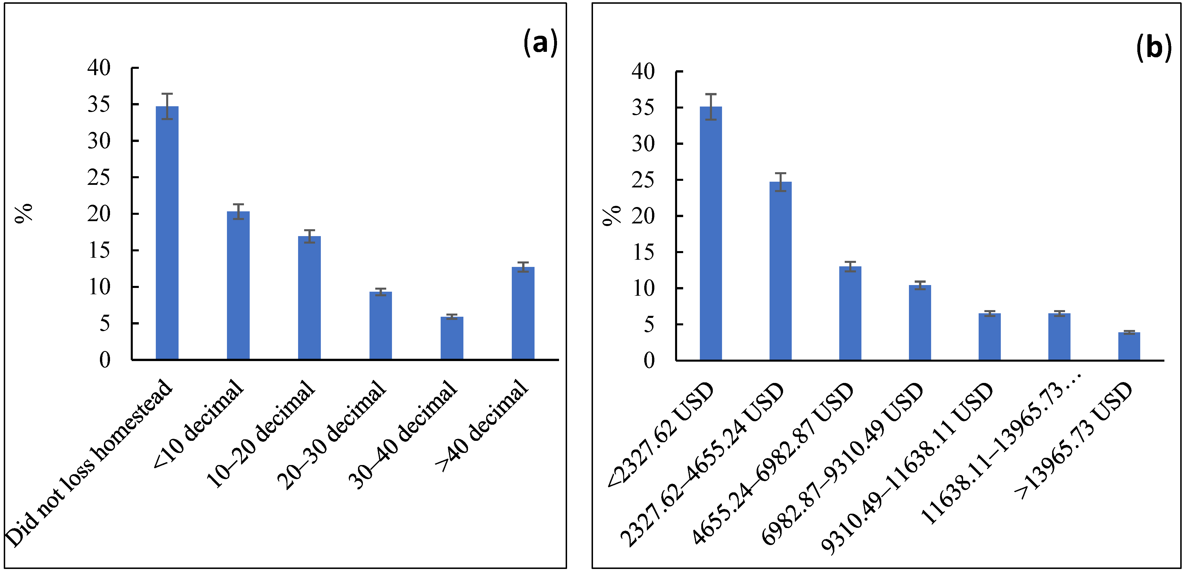
Loss of Homestead Land and Present Value

A large number of people have lost their homestead land in Bangladesh due to erosion. About 8700 ha of homestead and agricultural land is lost due to erosion which affects approximately 200,000 people annually increasing the vulnerabilities of food security and poverty [5,8,13,16]. The study revealed that erosion, has heavily loss of homestead land where the bar diagram represent economic values are so high. Figure 2a shows that, among (65.3%) of the homestead losses household majority (20.3%) of the households have lost their land below 10 decimals, while (16.9%) and (12.7%) have lost (10–20 decimal) and (>40 decimal) respectively. The mean loss of homestead land is 23.17 decimal. The significant difference in homestead land loss was (X2 = 37.186, df = 5, p ≤ 0.01). Figure 2b shows the economic loss of homestead land. The mean economic loss was in (3188.84 USD).
Due to erosion on homestead land, about (35.1%) of households suffered a financial loss (<2327.62 USD). It also revealed that (24.7%) of households have faced (2327.62–4655.24 USD); 13% were in (4655.24–6982.87 USD); 10.4% (6982.87–9310.49 USD) and only (3.9%) have faced (>13,965.73 USD) for losing homestead land. The significant difference in economic loss of a homestead is (X2 = 42.36, df = 6, p = < 0.01).

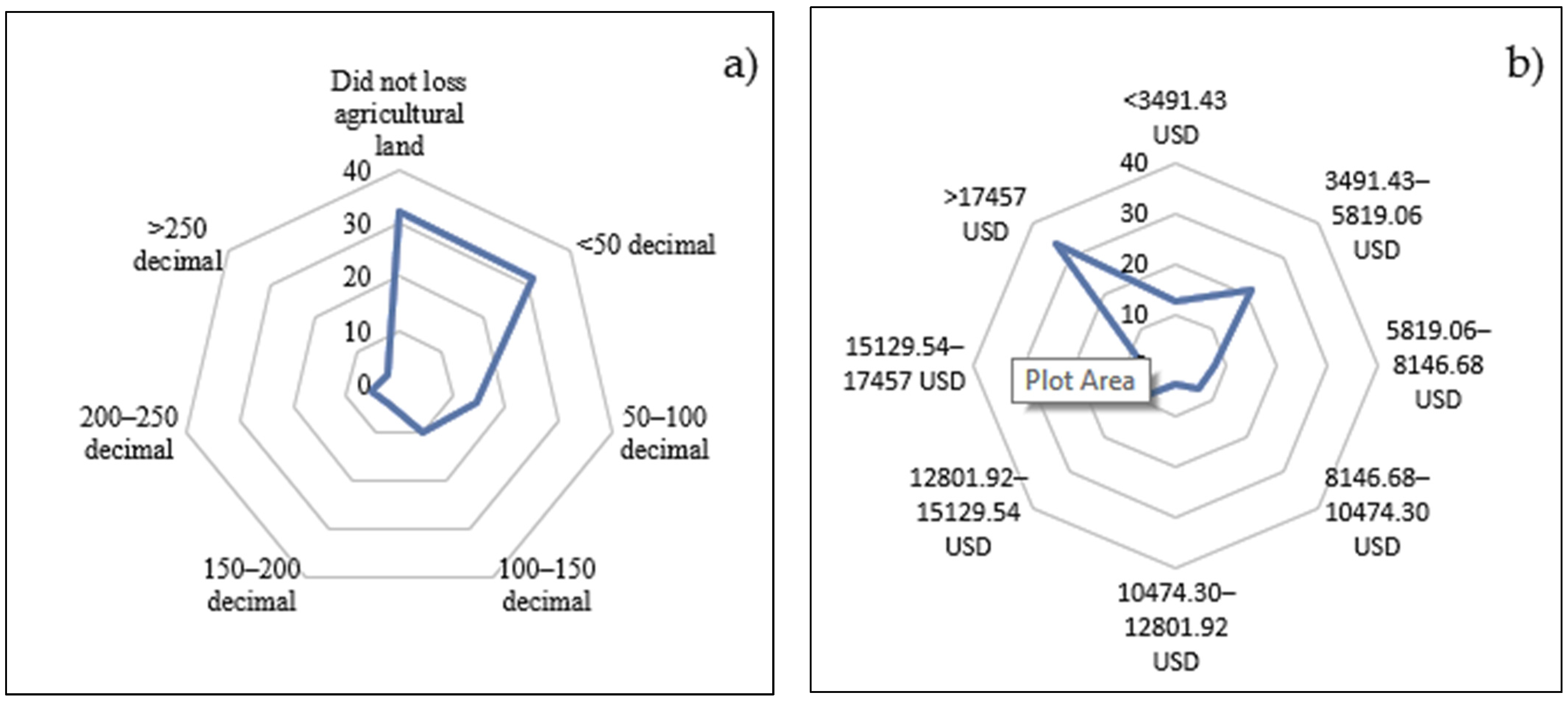
Loss of Agricultural Land and Approximate Present Value

Agriculture land is the country’s main resource, providing economic and food support for living. Almost 48% of the total population is directly dependent on agriculture [3]. Riverbank erosion severely damaged agricultural land and many farmers became poor overnight by losing their agricultural land, production and associated farming income [48]. Therefore, the loss of agricultural land has great socio-economic impacts on households. The results show that 32.2% of households have not lost any agricultural land due to erosion. Aside from the portion that did not lose agricultural land, the majority (31.4%) of households lost less than 50 decimal lands (Figure 3a). About 14.4% have lost (50–100 decimal). The mean agricultural land loss was 79.85 decimal. The land loss differed significantly (X2 = 78.71, df = 6, p = < 0.01). Approximately 10.2% of households lost (100–150 decimal); 4.2% were lost (150–200 decimal) and 2.5% lost (>250 decimal). Figure 3b shows the economic loss of agricultural land.
Most of the households (33.8%) have lost their maximum land value > 17,457.17 USD. The small percentage of households (12.5%) have lost their minimum land value < 3491.43 USD. The mean economic loss of agricultural land was 11,451.90 USD. Significant difference is (X2 = 46.20, df = 7, p ≤ 0.01).

3.2.2. Perceived Impacts of Riverbank Erosion on Livelihoods

The rural household’s vulnerability depends on contact with and usage of livelihood capitals, i.e., human, physical, agricultural, economic, and social [49,50,51]. The riverbank erosion is the most susceptible natural hazard that contributes to the loss of land and livelihood resources resulting in increased vulnerability to food insecurity and malnutrition and poverty [6,12,14,15].
Then, the perceived impacts of riverbank erosion are broadly categorized based on the capital assets on which the households depend (Table 3). Riverbank erosion is the key reason for a huge number of people migrating permanently. Moreover, the demographic and socio-economic concerns about erosion are extreme and frequently enormous in this region [20]. Because of poverty and a lack of resources [20], About half percentage of all homeless people suffer from erosion and are unable to rebuild their home. The study revealed that for human assets, the majority (39.8%) of the households have faced severe migration impacts due to erosion while 28.8% have moderate, and 31.4% have low. Food insecurity and malnutrition also increased due to agricultural income reduction and land loss by erosion that 45.8% of the respondent perceived as having low impacts, where 16.1% had severe faced. Food insecurity also influences health status such that 28.8% of households perceived it has low impacts, while 48.3% consider it moderate and 22.9% severe.
Riverbank erosion heavily damages physical structures as well as livelihood resources [52,53]. In our study, physical and agricultural assets are enormously affected by erosion, which results in increasing livelihood vulnerability. For physical assets, the erosion heavily damaged respondents’ homesteads, property, roads, and embankment, transport, institutions, etc. About 39.8% of households have perceived that erosion has severely impacted homestead property, 39% have moderate, and 21.2% have a low-level impact. The majority of the households (49.2%) have perceived erosion as severely damaged road and embankment, and only 10.2% have perceived low-level impact. The transportation and institutions’ low and severe perceived impacts ratios were 23.7%:16.9% as low and 37.3%:41.5% as severe. Agricultural land is enormously eroded and depleted into the river by erosion, and also the crop fields are damaged, forcing farmers to change their cropland patterns. The study revealed that most of the households (56.8%) have severely faced having their agricultural land depleted by river water, while 36.4% have faced moderate and 6.8% have faced low-level impacts. About 40.7% of respondents perceived that erosion moderately damages their crop land where 48.3% were severe, and 11% had faced low impact. The impact of erosion on social assets and their levels of impacts or threat is represented in Table 3. In Bangladesh, riverbank erosion is one of the most damaging hazards that enormously affects the economic sector [7,8,29,54].
In the study, most households are mainly dependent on agriculture for their livelihood, which provides them with base financial support and food security. Therefore, in economic assets, the majority (48.3%) of households have a perception that erosion severely reduced income from agriculture, while 34.7% have a perception that it has reduced moderately (Table 3). The erosion is decreasing savings due to low income and 42.4% of households have faced that erosion which moderately impacts savings, 37.3% have faced severe erosion.

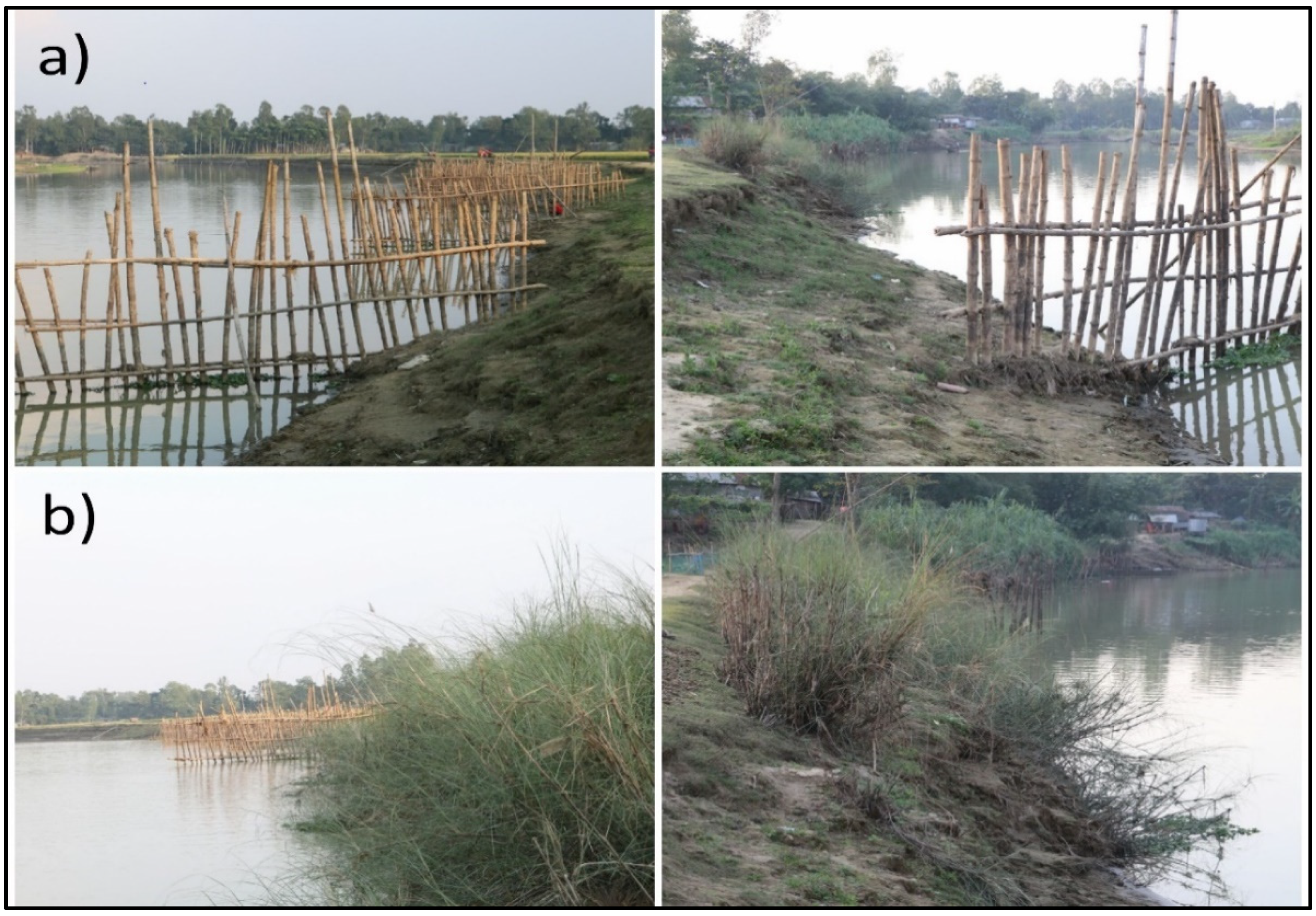
3.3. Traditional Erosion Control Approaches and Livelihoods Resilience

The study shows that despite enormous losses of erosion i.e., socio-economic losses, agricultural land loss, and reduced production, physical asset damages, migration, loss of homestead properties, etc. the poor and other community households were struggling to sustain and improve their livelihoods through the utilization of their traditional erosion control approaches. The study shows that mainly two traditional erosion control approaches, namely bundling’s (bamboo wall) and bank vegetation (bulrushes) and also combined use of these two approaches, were practiced by the households based on their previously practiced knowledge, experience, and insight of erosion (Table 4 and Figure 4).
The study shows that the majority (54.2%) of the households practiced bundling’s (bamboo wall) their approaches along with the erosion-prone bank sides of the river to control erosion. The households’ perceptions about the effectiveness of these approaches to reducing erosion are shown in Table 4. The level of effectiveness from high to low was observed in order to bulndlings > bundling + bank vegetation > bank vegetation respectively.
Households placed bundling’s (bamboo wall) for partial crosswise and vertical barrier to the approach flow and bring fewer disturbances to the river flow. The multilayered bundling’s protecting erosion because of crosswise and vertical barrier and non-uniform vertical circulation of suspended sediment Figure 4a. Within the lower half of the flow depth, the major portion of the sediment flow is concentrated. Households installed some bundling’s (bamboo wall) vertically into the river’s based on the river width and strength. The vertical bamboo stake is held in place by horizontal ones of the same length, as shown in the Figure 4a. The bamboo stakes are stuffed with wooden planks, sacks of jute and straw to reinforce the structure. About 33.1% have practiced bundlings + bank vegetation while a small portion or about 12.7% have practiced only bank vegetation.
Households use bulrushes as bank vegetation in the study area. The vegetation (bulrushes) directly protects the riverbank from erosion by decreasing the adjacent bank shear stresses and flow conveyance capacity. The vegetation modifies the soil properties, resulting in increasing soil strength due to reinforcing properties of roots and lowering pore water pressures (Figure 4b). These approaches are cost-effective and eco-friendly, and they were implemented during the dry season because of the erosion-prone area and low water level in the river.

3.3.1. Perceptions about Traditional Erosion Control Approaches and Livelihood Resiliency

These traditional approaches provide base support to the households in the area for controlling erosion that help them reduce the loss of homestead properties, agricultural land, physical assets, migration, etc. The study shows that most of the households (40.7%) have perceived “traditional measures-(previously practiced and potential future) make livelihood resilience” while 31.4% have medium; 17.8% have low and only a small portion 10.2% have perceived that traditional measure do not create resilience (Table 5). About 24.6% of households perceived that traditional measure highly help to protect agricultural land, crop fields, and production where the medium and low ratios are 29.7% and 26.3%. Migration is one of the most significant impacts of erosion in the study region, where traditional measures stop migration from large quantity to low. It revealed that most (36.4%) of the households have perceived traditional measures to provide high support to stop seasonal migration from erosion with 27.1% as medium and 15.3% as low.
Household’s perceptions about protecting community institutions, residential areas are represented in Table 5. Physical assets bundling’s provides high protection in this case Traditional measures are perceived to protect physical assets by approximately 40.7% of households, 21.2% by a medium level of protection, and 16.1% by a low level of perception. The engineering erosion control approaches are very time-consuming and costly, and local households are not involved in these measures. On the other hand, this traditional approach is implemented with the local households, and it’s cost-effective and provides rapid and sustainable base support against erosion. Above the perception output of households, the data represents that traditional erosion control approaches control riverbank erosion and increase the livelihood resilience of the affected households.

3.3.2. Factors Influencing Traditional Approaches That Makes Livelihoods Resilience

Table 6 represents the regression outputs for factors affecting the traditional control approaches that make livelihoods resilient. Among the independent variables, age showed significance. For instance, as the household age increases, the respondents are more likely to take traditional control approaches. In other words, aged homestead families have more information also, experience by their age than younger homestead families. The variable education of households represents high significance (with a p-value of 0.004 and coefficient of 0.261). This implies that the education level increases to take traditional control approaches, which gives great resiliency to the household’s livelihoods.
Family size has represented significant output with (p-value 0.027 and coefficient −0.163), which indicates if a family has more family individuals, they are locked into taking traditional control approaches effortlessly. The occupation variable has represented an insignificance relationship (p-value 0.651 and coefficient −0.045), which denotes that they are involved in different fields, so they are not taking traditional control approaches jointly. Experienced riverbank erosion represents measurable significance with the dependent variable at (p-value of 0.0294 and a coefficient of 0.318), which means the households have experienced riverbank erosion and take traditional control approaches. The farm size has represented an insignificant relationship at a p-value (0.586) and a negative coefficient (−0.072) with traditional control approaches.

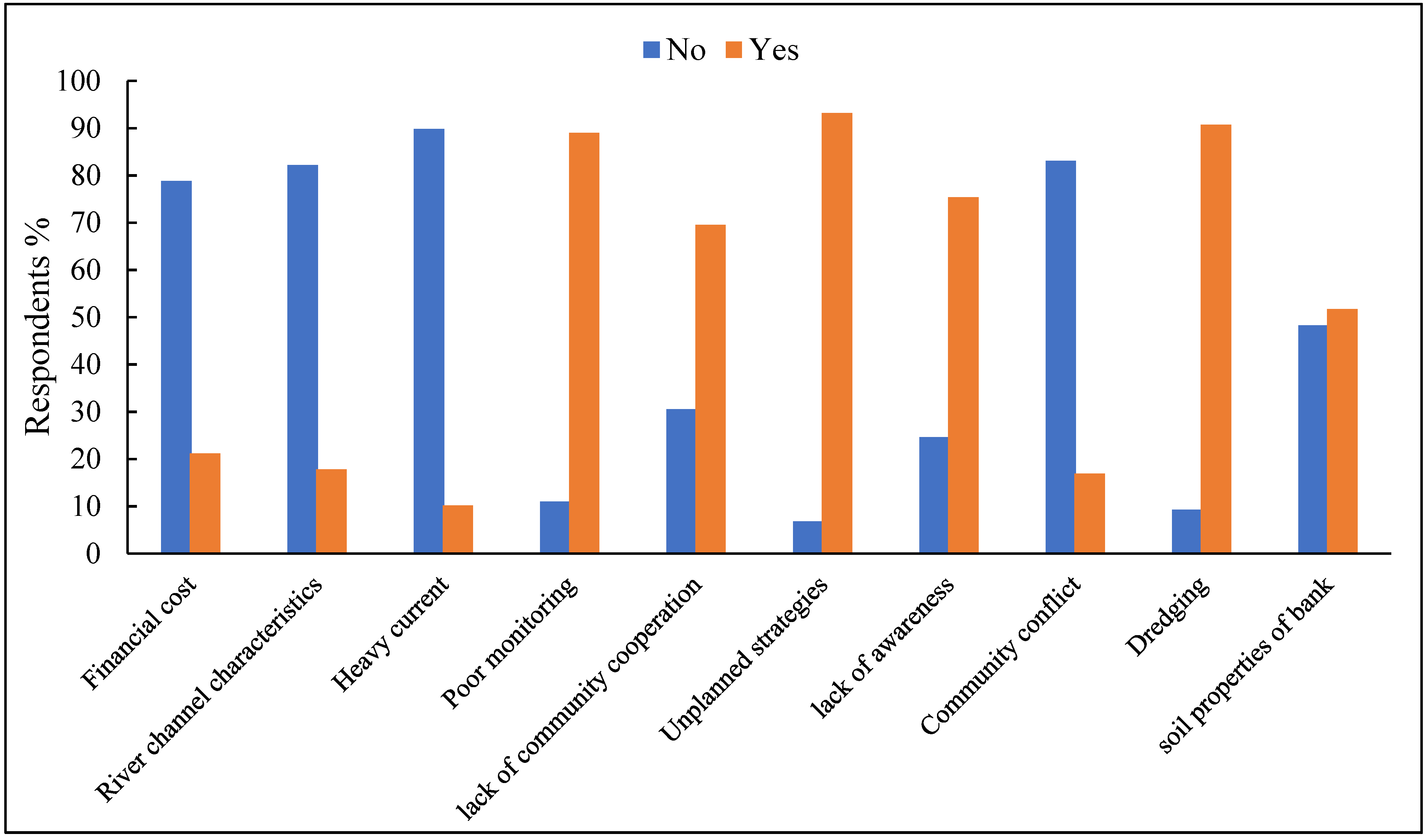
3.4. Factors Those Barrier to Taken Traditional Control Measures

Traditional control measures provide great effort for controlling erosion that protect people’s homestead properties, agricultural assets, human assets, etc. Besides this prodigious feedback, the study indicates that there are some factors that influence control measures (Figure 5). The study revealed that a small portion of households’ perceived financial cost, river channel characteristics, and heavy current influences, have taken control measures, and the ratio of these three factors is 21.2%; 17.8%; and 10.2% respectively. Figure 5 represents those factors, namely- poor monitoring, community cooperation, lack of awareness, and unplanned strategy, have influenced taking traditional measures.
The study shows that most (90.7%) of the households perceived dredging to greatly influenced them to take measures because dredging damages the natural flow of water and makes riverbanks more vulnerable to erosion (Figure 5).

4. Conclusions and Policy Implications

The research looked into traditional erosion control methods at the local level as well as livelihood resilience in the face of riverbank erosion. The study revealed that traditional erosion control approaches protect agricultural land, crop fields, and production rapidly and sustainably, and reducing damage to infrastructure, roads, embankments, and transportation in the region. The traditional erosion control approach is both cost-effective and eco-friendly. The households recognize the effects of the erosion hazards on various assets like livelihoods, physical, economic, agriculture, etc. which include loss of homestead and agricultural land, savings, agricultural income damage, access to education and health facilities, poor crops and yields, etc. resulting in an increased livelihood vulnerability. A significant difference is noticed among the different factors that influenced the traditional erosion control approaches that create resilient livelihoods. Age, education, family size, and erosion experience all positively increase the possibility of taking the traditional erosion control approaches. But occupation, earnings, and farm size have no significant influence on traditional erosion control approaches. Aside from engineered erosion control approaches, rural households protect erosion with traditional measures and build long-term livelihood resilience.
Therefore, traditional approaches could be encouraged with appropriate policy support. For instance, government and non-government organizations can provide support or credit facilities to poor households for better output to control erosion and improve livelihood resilience. Institutional contact regarding credit facilities is pivotal to promoting traditional erosion control approach practices. Skill development training for households to cope with erosion and prepare them for flood hazards, particularly during the wet season, is also important. It is also indispensable to improve correspondence, transport, and admittance to business sectors and administrations to assist the powerful and coherent reception of variation techniques across all vulnerable regions in Bangladesh.

Supplementary Materials

The following are available online at https://www.mdpi.com/article/10.3390/su14042348/s1, Questionnaire On Assessing Riverbank Erosion and Livelihood Resil ence Using Traditional Approaches in Northern Bangladesh.

Author Contributions

Conceptualization, A.A.M. and A.R.M.T.I.; methodology, G.M.M.A.; software, A.A.M.; validation A.R.M.T.I., E.A., G.M.M.A. and S.C.P.; investigation, E.A. and A.R.M.T.I.; data curation, A.A.M.; writing—original draft preparation, A.A.M., S.C.P. and A.R.M.T.I.; writing—review and editing, G.M.M.A.; visualization, and A.R.M.T.I.; supervision, and E.A.; project administration, and A.R.M.T.I.; funding acquisition, E.A. All authors have read and agreed to the published version of the manuscript.

Funding

This research received no external funding.

Institutional Review Board Statement

The study was conducted according to the guidelines of the Declaration of Helsinki, and approved by the Institutional Review Board (or Ethics Committee) of Dept. of Disaster Management, Begum Rokeya University, Rangpur (protocol code 2021/1000(3) and 15 April 2021.

Informed Consent Statement

Written informed consent has been obtained from the participants to publish this paper.

Data Availability Statement

Data are available on reasonable request on corresponding author.

Acknowledgments

The authors gratefully acknowledge generous philanthropic support from the Office of the Vice President of the Rabdan Academy, The United Arab Emirates (UAE). The authors also appreciate the Krishi Gobeshona Foundation (KGF) for funding this work. Authors also acknowledge the participants of the survey for their kind cooperation.

Conflicts of Interest

The authors declare no conflict of interest.

References

  1. Dekens, J. Local Knowledge for Disaster Preparedness: A Literature Review; International Centre for Integrated Mountain Development: Kathmandu, Nepal, 2007. [Google Scholar]
  2. Intergovernmental Panel on Climate Change (IPCC), Climate Change. Impacts, Adaptation, and Vulnerability; World Meteorological Organization: Geneva, Switzerland, 2014. [Google Scholar] [CrossRef]
  3. Intergovernmental Panel on Climate Change (IPCC), Climate Change. Impacts, Adaptation and Vulnerability; Contribution of Working Group II, Fourth Assessment Report; Intergovernmental Panel on Climate Change, Cambridge University Press: Cambridge, UK, 2007. [Google Scholar]
  4. World Bank. Turn Down the Heat: Climate Extreme Regional Impact and Case for Resilience; A Report for the World Bank by the Potsdam Institute for Climate Impact Research and Climate Analytics: Washington DC, MD, USA, 2013. [Google Scholar]
  5. Government of Bangladesh (GoB). Comprehensive Disaster Management Programme’, Phase II (2010-14); Ministry of Food and Disaster: Dhaka, Bangladesh, 2010. [Google Scholar]
  6. Alam, G.M.M. An Assessment of the Livelihood Vulnerability of the Riverbank Erosion Hazard and Its Impact on Food Security for Rural Households in Bangladesh. Ph.D. Thesis, School of Commerce, University of Southern Queensland, Toowoomba, Australia, 2016. [Google Scholar]
  7. Alam, G.M.M. Livelihood cycle and vulnerability of rural households to climate change and hazards in Bangladesh. Environ. Manag. 2017, 59, 777–791. [Google Scholar] [CrossRef] [PubMed]
  8. Penning-Rowsell, E.C.; Sultana, P.; Thompson, P.M. The “last resort”? Population movement in response to climate related hazards in Bangladesh. Environ. Sci. Policy 2013, 27, 44–59. [Google Scholar] [CrossRef]
  9. Alam, G.M.M.; Alam, K.; Shahbaz, M. Influence of institutional access and social capital on adaptation choices: Empirical evidence from vulnerable rural households in Bangladesh. Ecol. Econ. 2016, 130, 243–251. [Google Scholar] [CrossRef]
  10. Centre for Environment and Geographic Information Services (CEGIS). Prediction of River Bank Erosion along the Jamuna, the Ganges, the Padma and the Lower Meghna Rivers in 2012; Centre for Environment and Geographic Information Services: Dhaka, Bangladesh, 2012. [Google Scholar]
  11. Government of Bangladesh. Disaster Report 2013. 2014. Available online: http://reliefweb.int/report/Bangladesh/disaster-report-2013 (accessed on 20 January 2015).
  12. Alam, G.M.M.; Alam, K.; Shahbaz, M.; Clarke, M.L. Drivers of vulnerability to climatic change in riparian char and river-bank households in Bangladesh: Implications for policy, livelihoods and social development. Ecol. Indic. 2007, 72, 23–32. [Google Scholar] [CrossRef]
  13. International Fund for Agricultural Development (IFAD). Rural Poverty in Bangladesh; International Fund for Agricultural Development; IFAD: Rome, Italy, 2013; 0p. [Google Scholar]
  14. Lein, H. Hazards and force’ migration in Bangladesh. Nor. Geogr. Tidsskr. 2010, 54, 122–127. [Google Scholar] [CrossRef]
  15. Hutton, D.; Haque, E. Pattern of Coping and adaptation among erosion induced displacees in Bangladesh: Implications for hazard analysis and migration. Nat. Hazards 2003, 29, 387–403. [Google Scholar] [CrossRef]
  16. Alam, G.M.M.; Alam, K.; Mushtaq, S.; Khatun, M.N.; Leal Filho, W. Strategies and barriers to adaptation of hazard-prone rural households in Bangladesh. In Limits to Climate Change Adaptation; Filho, W.L., Nalau, J., Eds.; Springer: Berlin/Heidelberg, Germany, 2018; pp. 11–24. [Google Scholar]
  17. Aryal, J.P.; Sapkota, T.B.; Rahut, D.B.; Krupnik, T.J.; Shahrin, S.; Jat, M.L.; Stirling, C.M. Major climate risks and adaptation strategies of smallholder farmers in coastal Bangladesh. Environ. Manag. 2020, 66, 105–120. [Google Scholar] [CrossRef]
  18. Aamir, S.; Sharma, N. Riverbank protection with Porcupine systems: Development of rational design methodology. ISH J. Hydraul. Eng. 2015, 21, 317–332. [Google Scholar] [CrossRef]
  19. Sanyal, T. Controlling Riverbank Erosion with Jute Geotextiles. In Jute Geotextiles and their Applications in Civil Engineering; Developments in Geotechnical Engineering; Springer: Singapore, 2017. [Google Scholar] [CrossRef]
  20. Islam, M.F.; Rashid, A.N.M.B. Riverbank erosion displaces in Bangladesh: Need for institutional response and policy intervention. Bangladesh J. Bioeth. 2011, 2, 4–19. [Google Scholar] [CrossRef]
  21. Ahmed, I. People of Many Rivers: Tales from the Riverbanks; The University Press Limited: Dhaka, Bangladesh, 2015. [Google Scholar]
  22. Mollah, T.H.; Ferdaush, J. Riverbank erosion, population migration and rural vulnerability in Bangladesh (a case study on Kazipur Upazila at Sirajgonj District). Environ. Ecol. Res. 2015, 3, 125–131. [Google Scholar] [CrossRef]
  23. Karim, A.H.M.Z. Flood and Riverbank Erosion Displaces of Two Different Flood Areas of Bangladesh: A Situational Study on Their Indigenous Survival Strategies. Asian Soc. Sci. 2014, 10, 16. [Google Scholar]
  24. Rahman, M.R. Impact of riverbank erosion hazard in the Jamuna floodplain areas in Bangladesh. J. Sci. Found. 2010, 8, 55–65. [Google Scholar] [CrossRef]
  25. Hutton, D.; Haque, E. Human vulnerability, dislocation and resettlement: Adaptation process of riverbank erosion-induced displacement in Bangladesh. Disasters 2004, 28, 41–62. [Google Scholar] [PubMed]
  26. Elahi., K.M.; Ahmed, K.S.; Malizuddin, M. (Eds.) Riverbank Erosion, Flood and Population Displacement in Bangladesh; Riverbank Erosion Study; Jahangirnagar University: Dhaka, Bangladesh, 1991. [Google Scholar]
  27. Zaman, M.Q. The displaced poor and resettlement policies in Bangladesh. Disasters 1991, 15, 117–125. [Google Scholar] [CrossRef] [PubMed]
  28. Zaman, M. The socioeconomic and political context of adjustment to riverbank erosion hazard and population resettlement in Bangladesh. Hum. Organ. 1989, 48, 196–205. [Google Scholar] [CrossRef]
  29. Makenro, M.B. World Disaster Report, 2001; International Federation of the Red Cross and Red Crescent Societies: Geneva, Switzerland, 2000. [Google Scholar]
  30. Rogge, J.; Haque, C. Riverbank erosion hazard, rural population displacement, and institutional responses and policies in Bangladesh. In Proceedings of the Annual Meeting of the Association of American Geographers, Portland, Oregon, 22–26 April 1987. [Google Scholar]
  31. Hossain, M. Economic effects of riverbank erosion: Some evidence from Bangladesh. Disasters 1993, 17, 25–32. [Google Scholar] [CrossRef]
  32. Islam, M.S. Riverbank Erosion and Sustainable Protection Strategies. J. Eng. Sci. 2011, 2, 63–72. [Google Scholar]
  33. Termini, D. Use of Vegetation as Biomaterial for Controlling Measures of Human Impact on the Environment. Hindawi. Adv. Mater. Sci. Eng. 2019, 2019, 7945839. [Google Scholar] [CrossRef] [Green Version]
  34. Thompson, A.; Oberhagemann, K.; She, Y. Geobag stability for riverbank erosion protection structures: Physical model study. Geotext. Geomembr. 2019, 48, 110–119. [Google Scholar] [CrossRef]
  35. Bangladesh Bureau of Statistics (BBS). Bangladesh Population Census 2011, Statistics Division, Ministry of Planning; Government of the People’s Republic of Bangladesh: Dhaka, Bangladesh, 2011. [Google Scholar]
  36. Cochran, W.G.; Son, W.J. Sampling Techniques, 3rd ed.; John Wiley and Sons: New York, NY, USA, 1977. [Google Scholar]
  37. Liao, T.F. Interpreting Probability Models: Logit, Probit, and Other Generalized Linear Models; Quantitative Applications in the Social Sciences; SAGE Publications Inc.: London, UK, 1994; Volume 101. [Google Scholar]
  38. Aldrich, J.H.; Nelson, F.D. Linear Probability, Logit and Probit Model: Quantitative Application in the Social Science-Sera Miller McCun; Sage pub. Inc., University of Minnesota and Iola: London, UK, 1984. [Google Scholar]
  39. Ahmed, Z.; Guha, G.S.; Shew, A.M.; Alam, G.M.M. Climate change risk perceptions and agricultural adaptation strategies in vulnerable riverine char islands of Bangladesh. Land Use Policy 2021, 103, 105295. [Google Scholar] [CrossRef]
  40. Asrat, P.; Simane, B. Farmers’ perception of climate change and adaptation strategies in the Dabus watershed. North-West Ethiop. Ecol. Processes 2018, 7, 7. [Google Scholar] [CrossRef] [Green Version]
  41. Islam, M.; Paul, S. People’s perception on agricultural vulnerabilities to climate change and SLR in Bangladesh: Adaptation strategies and explanatory variables. Int. J. Agric. Res. Innov. Technol. 2018, 8, 70–78. [Google Scholar] [CrossRef]
  42. Islam, M.S.; Kabir, M.H.; Ali, M.S.; Sultana, M.S.; Mahasin, M. Farmers’ knowledge on climate change effects in agriculture. Agric. Sci. 2019, 10, 386–394. [Google Scholar] [CrossRef] [Green Version]
  43. Murray, L.; Nguyen, H.; Lee, Y.F.; Remmenga, M.D.; Smith, D.W. Variance Inflation Factors in regression models with dummy variables. Available online: https://newprairiepress.org/cgi/viewcontent.cgi?article=1034&context=agstatconference (accessed on 5 December 2021).
  44. Williams, R.; Allison, P.D.; Moral-Benito, E. Linear dynamic panel-data estimation using maximum likelihood and structural equation modeling. Stata J. Promot. Commun. Stat. Stata 2018, 18, 293–326. [Google Scholar] [CrossRef] [Green Version]
  45. Bangladesh Bureau of Statistics (BBS). Statistical Pocketbook of Bangladesh; Bangladesh Bureau of Statistics: Dhaka, Bangladesh, 2014.
  46. BBS. Yearbook of Agricultural Statistics; Bangladesh Bureau of Statistics: Dhaka, Bangladesh, 2012.
  47. Hossain, M.M.; Ferdousi, S. Assessment for role of GIS based natural disaster and planning activity in Bangladesh. Environ. Inform. Arch. 2004, 2, 119–125. [Google Scholar]
  48. Islam, M.S.; Sultana, S.; Saifunnahar, M.; Miah, M.A. Adaptation of char livelihood in flood and river erosion areas through indigenous practice: A study on Bhuapur riverine area in Tangail. J. Environ. Sci. Nat. Resour. 2014, 7, 13–19. [Google Scholar] [CrossRef]
  49. Carney, D. Implementing the sustainable rural livelihoods approach. In Sustainable Rural Livelihoods: What Contribution Can We Make? Carney, D., Ed.; Department of International Development: London, UK, 1998. [Google Scholar]
  50. Chamber, R.; Conway, G. Sustainable Rural Livelihoods: Practical Concepts for the 21st Century; Institute of Development Studies: Brighton, UK, 1992. [Google Scholar]
  51. DFID. Sustainable Livelihoods Framework Guideline Sheets; Department of International Development: London, UK, 1999.
  52. Brouwer, R.; Akter, S.; Brander, L.; Haque, E. Socioeconomic Vulnerability and Adaptation to Environmental Risk: A Case Study of Climate Change and Flooding in Bangladesh. Risk Anal. 2007, 27, 313–326. [Google Scholar] [CrossRef] [Green Version]
  53. Islam, A.R.M.T.; Hasanuzzaman, M.; Jaman, M.; Alam, E.; Mallick, J.; Alam, G.M.M.; Sattar, M.A.; Techato, K. Assessing Farmer’s Typologies of Perception for Adopting Sustainable Adaptation Strategies in Bangladesh. Climate 2021, 9, 167. [Google Scholar] [CrossRef]
  54. Mamun, A.A.; Roy, S.; Islam, A.R.M.T.; Alam, G.M.M.; Alam, E.; Pal, S.C.; Sattar, M.A.; Mallick, J. Smallholder Farmers’ Perceived Climate-Related Risk, Impact, and Their Choices of Sustainable Adaptation Strategies. Sustainability 2021, 13, 11922. [Google Scholar] [CrossRef]
Figure 1. Map showing the survey sites in Rowmari Bangladesh.
Sustainability 14 02348 g001
Figure 2. (a) Quantity of homestead land loss and (b) economic loss of homestead land loss.
Sustainability 14 02348 g002
Figure 3. (a) Quantity of agricultural land loss and (b) economic value of agricultural loss land.
Sustainability 14 02348 g003
Figure 4. Traditional erosion control approaches (a) bundling’s; (b) bank vegetation.
Sustainability 14 02348 g004
Figure 5. Factors those barriers to taken traditional control measures.
Sustainability 14 02348 g005
Table 1. Description of the variables used in the probit model.
VariablesMeasurement MeanSD
Dependent variables
Traditional control approaches (dummy)1 = traditional approaches make livelihoods resilience; 0 = otherwise 0.660.47
Independent variables
Age (continuous)No. of years47.9513.7
Education (dummy) 0 = Illiterate; 1 = primary; 2 = Secondary; 3 = Higher-secondary; 4 = Graduation
Occupation (dummy)0 = Agriculture; 1 = Business + agriculture; 2 = Service + agriculture; 3 = Day labor; 4 = Others
Family sizeNo. of family members5.112.01
Earning membersNo. of earning members1.390.72
Farm SizeFarm size in acres0.620.78
Erosion experience (dummy)0 = Witness; 1 = Victim
Table 2. Demographic and farm characteristics of the respondents.
RespondentsMeanSDp-Value
CharacteristicsCategoriesN(%)
Age (Years)≤30 years75.947.9513.7<0.01
31–45 years5344.9
46–60 years3933.1
61–65 years1916.1
EducationIlliterate7261 <0.01
Primary2420.3
Secondary1210.2
Higher-secondary21.7
Graduation86.8
Family Size (Numbers)Small (up to 4)5647.55.002.01<0.01
Medium (5–6)3731.4
Large (>6)2521.2
OccupationAgriculture8874.6 <0.01
Business + Agriculture75.9
Service + Agriculture75.9
Day labor43.4
Others1210.2
Earning membersOne85721.390.72<0.01
Two2218.6
Three119.3
Annual family income (USD)Low (up to 425 USD)1210.2792.88206.04<0.01
Lower middle (425–566 USD)1512.7
Upper middle (566–850 USD)1916.1
High (>850 USD)7261
Farm Size (Acres)Landless (0.5 acres)7664.40.620.78<0.01
Small (1.49–0.6 acres)3428.8
Medium (1.5–2.49 acres)65.1
Large (>2.5 acres)21.7
Erosion ExperiencesVictim9378.8 <0.01
Witness2521.2
Table 3. Livelihoods impacts of riverbank erosion.
Levels of Threat and Impact (%)
Assets TypesThreat/ImpactsDescriptionLowModerateSevere
Human AssetsFood insecurity and malnutritionIncreased due to loss of agricultural land, low production and income45.838.116.1
MigrationInduced migration due to loss of homestead and agricultural land31.428.839.8
Disease/HealthDue food insecurity and partial
access to health services
28.848.322.9
Physical assetsHomestead propertyLoss homestead property due to erosion21.23939.8
Roads and embankmentDamaged roads and embankment10.240.749.2
Market placeLoss of many market place3940.720.3
TransportDamaged transportation facilities 23.73937.3
Latrine facilityDamaged latrine facilities 31.431.437.3
Institutions (school, mosque, etc.)Damaged intuitions facilities 16.941.541.5
Agricultural
assets
Agricultural crops fieldDamage agricultural crops field by erosion1140.748.3
Agricultural landLoss of agricultural land into river6.836.456.8
Cropland patternChange cropland pattern 40.739.819.5
Economic assetsIncome from agricultureReduced due to loss of agricultural land, crops and yields16.934.748.3
SavingsDecreasing saving due to low income 20.342.437.3
Credit facilitiesDue to decreasing formal and non-formal sources of credit 19.541.539
Social assetsEducational facilities Hampered due to losing educational intuitions by erosion 26.348.325.4
Residential facilityDeteriorated residential facilities 35.63925.4
Organizational supportLimited involvement due to insufficient organization 21.250.828
Community cooperationLimited cooperation among community. The affected households hardly get support from the community2245.832.2
Table 4. Traditional erosion control approaches.
RespondentsLevel of Effectiveness (%)
Traditional Approaches(%)LowMediumHigh
Bundlings54.21130.558.5
Bank vegetation12.745.82826.3
Bundlings + bank vegetation33.115.337.347.5
Table 5. Perceptions about traditional erosion control approaches and livelihood resiliency.
Respondentsp-Value
Households Perceptions about Traditional Control Approaches and Livelihood ResiliencyCategory(%)
Traditional measures- (previously practiced and potential future) makes livelihoods resilienceNo10.2<0.01
Low17.8
Medium31.4
High40.7
Protect agricultural land, crops fields and production No19.5>0.05
Low26.3
Medium29.7
High24.6
Protecting physical assets including household’s properties, infrastructure, road, embankment, transportation, etc. No22.0<0.01
Low16.1
Medium21.2
High40.7
Stop seasonal migrationNo21.2<0.01
Low15.3
Medium27.1
High36.4
Protect community institutions, residential facilitiesNo28.8<0.01
Low14.4
Medium21.2
High35.6
Provide rapid and sustainable a base support against erosionNo17.8<0.01
Low16.9
Medium26.3
High39.0
Table 6. Estimate of Probit model: Factors influencing traditional control approaches that makes livelihoods resilience.
VariablesCoefficientStandard Errorp-Value
Age0.0060.0090.050 **
Education0.2610.1280.004 ***
Occupation −0.0450.0980.651
Family size−0.1630.1470.027 **
Earning members0.0200.2490.937
Farm size −0.1920.3810.614
Erosion experience 0.3180.3030.0294 **
Significant levels: ** p ≤ 0.05; *** p ≤ 0.01.
Publisher’s Note: MDPI stays neutral with regard to jurisdictional claims in published maps and institutional affiliations.

