Article

Community and Scientists Work Together to Identify Koalas Within the Plantations Inside the Proposed Great Koala National Park in New South Wales, Australia

1
Koala Research-CQ, Central Queensland University, Bruce Hwy, North Rockhampton, QLD 4702, Australia
2
School of Veterinary Science Gatton, The University of Queensland, Gatton, QLD 4343, Australia
3
Institute for Ethics, Governance and Law, Griffith University, Brisbane, QLD 4111, Australia
4
School of Business and Law, Central Queensland University, Melbourne, VIC 3000, Australia
5
School of Humanities, Creative Industries and Social Science, University of Newcastle, Callaghan, NSW 2308, Australia
6
BrodiMapi LLC; brodimapi.com
7
Institute of Innovation, Science and Sustainability, Federation University Australia, Ballarat, VIC 3350, Australia
8
School of Arts, Federation University Australia, Ballarat, VIC 3350, Australia
9
Climate Action Beacon, Griffith University, Brisbane, QLD 4111, Australia
10
Geography, Planning, and Spatial Sciences, University of Tasmania, Dynnyrne, TAS 7005, Australia
*
Author to whom correspondence should be addressed.
Koala History and Sustainability Research Cluster.
Submission received: 3 July 2025 / Revised: 17 September 2025 / Accepted: 10 October 2025 / Published: 16 October 2025

Abstract

Simple Summary

This paper confirms the presence of both koalas and an original forest inside plantations within, but excluded from, the Great Koala National Park (GKNP), a national park proposed by the State Government of New South Wales, Australia. This was confirmed by means of an investigation into koala habitats within Tuckers Nob State Forest, which is located inside the proposed park. The area comprises zoned hardwood eucalypt plantations and is scheduled for logging in 2025–2026. Local citizen scientists, university researchers, and non-governmental organizations worked together to identify an original forest within the plantation area, look for koala scats, and conduct an aerial survey using a drone-mounted thermal camera. The findings indicate that plantation areas do provide important koala habitats, particularly due to the presence of an original forest, and need to be included in conservation strategies for this endearing, and endangered, animal.

Abstract

There is a widespread belief that koala conservation measures should be focused on ending forestry operations in native forests and that plantations should be the alternative source for timber. While advocates for conservation continue to promote this strategic approach, they overlook the fact that hardwood plantations also provide important habitats. Ongoing operations in both natural and planted forests continue to threaten the viability of the koala species, and populations in one of the koala’s core habitats in northern New South Wales (NSW) continue to decline. To improve conservation outcomes for this species in the wild, the Great Koala National Park (GKNP) has been proposed. While the process of establishing this park continues, ongoing forestry operations exert continuous pressure on koalas and their habitat within the proposed area of the park. This paper investigates how community stakeholders are collaborating with scientists to identify areas of high koala habitat value within the hardwood eucalypt plantations inside the proposed GKNP that are currently excluded from conservation and will be subject to ongoing timber extraction. Investigations of Tuckers Nob State Forest, which is inside the proposal area, confirmed the presence of both koalas and original forest inside the plantations which were excluded from conservation by the state government. Original trees and remnants were identified using historical aerial photography, which were orthorectified and matched against current NSW government imagery (SIX Maps); composite mosaics of photographic sheets and closeups (Quantum GIS) were imported into Google Earth Pro. Koala drone surveys, habitat ground-truthing, and on-ground scat and koala surveys of 120 ha involving various community stakeholders were conducted in December 2024 and revealed 25 koalas records, necessitating the reclassification of this area from plantation to prime koala habitat. Here, as in many other plantations in NSW, the findings of this study indicate significant numbers of original trees that are part of highly diverse nutrient-rich sites attractive to koalas. This leads to the conclusion that the exclusion of specific areas of the proposed park from conservation to allow for ongoing logging is inconsistent with recognized koala protection strategies. Hence, koala protection strategies need to consider the integrity of the reserve system in its entirety, and the whole area of the GKNP should be accorded the requisite status of a World Heritage Site.

1. Introduction

The koala (Phascolarctos cinereus) is an Australian marsupial unique to the continent, with the exception of captive populations in zoos across the world, but is listed domestically as endangered in NSW, Queensland (Qld), and the Australian Capital Territory [1]. Australia’s koalas may be divided into two wild meta-populations, one in the northern half of NSW, extending north into Queensland, and one in the south of the state, which extends south into Victoria. There are also populations in both Victoria and South Australia originally introduced through a number of insurance populations placed on the islands in the early twentieth century, when the species was facing extirpation due to overhunting for the fur trade [2]. Populations across most of the species’ range are in ongoing decline, primarily because of climate change, as well as the loss and fragmentation of their habitats due to human activities which include forestry, including the case study that forms the basis of this paper. In the language of the Gumbaynggirr, the First Nations people that INHABIT the region of what is now called the Mid North Coast of NSW, the word for koala is dunggirr [3]. This area is currently under assessment for a Great Koala National Park (GKNP) to halt the species’ decline. While the koala can still be found in the natural forests in this area, these forests have been impacted by the devastating Black Summer bushfires, and the koala meta-population of the region now largely resides in the unburnt forests and plantations along the coast.
Unfortunately, all the areas zoned plantation within the proposed GKNP have been excluded from the park assessment under the belief they are not native forest and were planted for forestry purposes. In NSW, hardwood plantations do not have to be expressly planted for the purpose of wood production. They may be made up of regrowth forests, zoned plantations, or sown with native seeds, and if they were planted, comprise local tree species favoured by koalas. They have also been established on high-diversity nutrient-rich sites that are attractive to koalas [4]. Significantly, they also contain original trees (an individual specimen in existence before plantation establishment, either as an isolated example or within a larger cohort of trees) and forest remnants (a patch of trees, which existed before plantation establishment) [5]. There is also the belief that the forest industry requires plantations, and these plantations must be part of the industry going forward [6]. The NSW Government, to date, has not publicly acknowledged the high conservation value of the plantation for koalas. This is problematic, as research indicates that koalas, like many other apex mammal species, require large areas of un-fragmented, continuous forest cover if they are to thrive as a population at the landscape level [7]. Habitat fragmentation is heavily impacting the populations along the east coast of Australia due to urban development; notably, the expansion of housing, increased traffic, and domesticated animals such as the dog are taking a heavy toll. This makes the NSW Mid North Coast an ideal location for a park, as there are still relatively large areas of undeveloped land, although in this region, forestry and, to a lesser extent, land clearing for agriculture are the main threats. Advocates for ongoing forestry operations argue that koalas inhabit a variety of forest types and do not require pristine old-growth forests to survive. This is true to a certain extent, but the frequency, intensity, and scale of forestry operations do play a role in population dynamics, most notably the level of disturbance created by intensive forest management, particularly plantation forestry, to which the region is subjected [2].
The research that forms the empirical component of this paper sought to determine the value of plantations as habitat for the koalas of the NSW Mid North Coast. This research was facilitated by the third author of this paper, as part of the research project Ensuring the sustainability of plantation management—a citizen science approach (protocol 2022/466). The data collection phase took place between 18 June 2024 and 13 January 2025. Using Tuckers Nob State Forest as a case study, this project relied heavily on local citizen-scientists to collect the necessary data. Despite the koala being a conservation flagship species [8,9] and receiving expansive public attention, consideration of the role of citizen science (CS) in scientific or koala conservation projects is still relatively uncommon. One of the first CS surveys was the “Great Koala Count” in South Australia (SA) in 2012 [10], and its iteration ”The Great Koala Count 2” [11], which is purported to have had an influence on policy-making in that state [12]. In Qld, [13] tested the effectiveness of CS in monitoring a declining koala population by developing guidelines and using these to improve the success of CS science projects. However, the data quality of such endeavors is varied [14]. For example, [15], a study in South East Qld points to the need to apply appropriate bias-correction techniques to CS-obtained data. Nevertheless, a modified CS approach to monitor individual koalas in Central Qld was successful [16]. A similar count to the one conducted in SA is conducted irregularly by the NSW National Parks Association, where the “Great Koala Count” is focused on the north coast of that state [17], and CS is used in attempts to monitor population trends in the north-west as well [18]. The research in Tuckers Nob found that from an ecological standpoint, plantations and the high-value habitat within them should not be discounted from conservation measures. CS was similarly integral to the project presented below, requiring, as it did, large numbers of records to make the case for the significance of the study area as habitat. It follows that such areas need to be included within the proposed park.

2. Materials and Methods

2.1. Description of the Study Area

This research is focused on Tuckers Nob State Forest (TNSF), which is part of the proposed Great Koala National Park to be situated on the mid-north coast of the Australian state of NSW. TNSF is zoned for forestry operations, and is located to the north of the Bellinger River, which flows through the township of Bellingen in the Bellingen Shire, NSW. It contains ~2457 ha of forest zoned as plantation (FMZ5 in NSW forest management classification), of which ~1678 ha is currently managed for wood production. It is part of a complex of plantation-dominated State Forests (SFs) surrounding the township in the epicenter of the proposed GKNP. Pine Creek SF lies to the east, Tarkeeth SF and Newry SF to the south. Bindarri National Park (NP) is situated to the north and east, and is zoned for conservation, as is Dorrigo NP, located to the north and west (Figure 1).
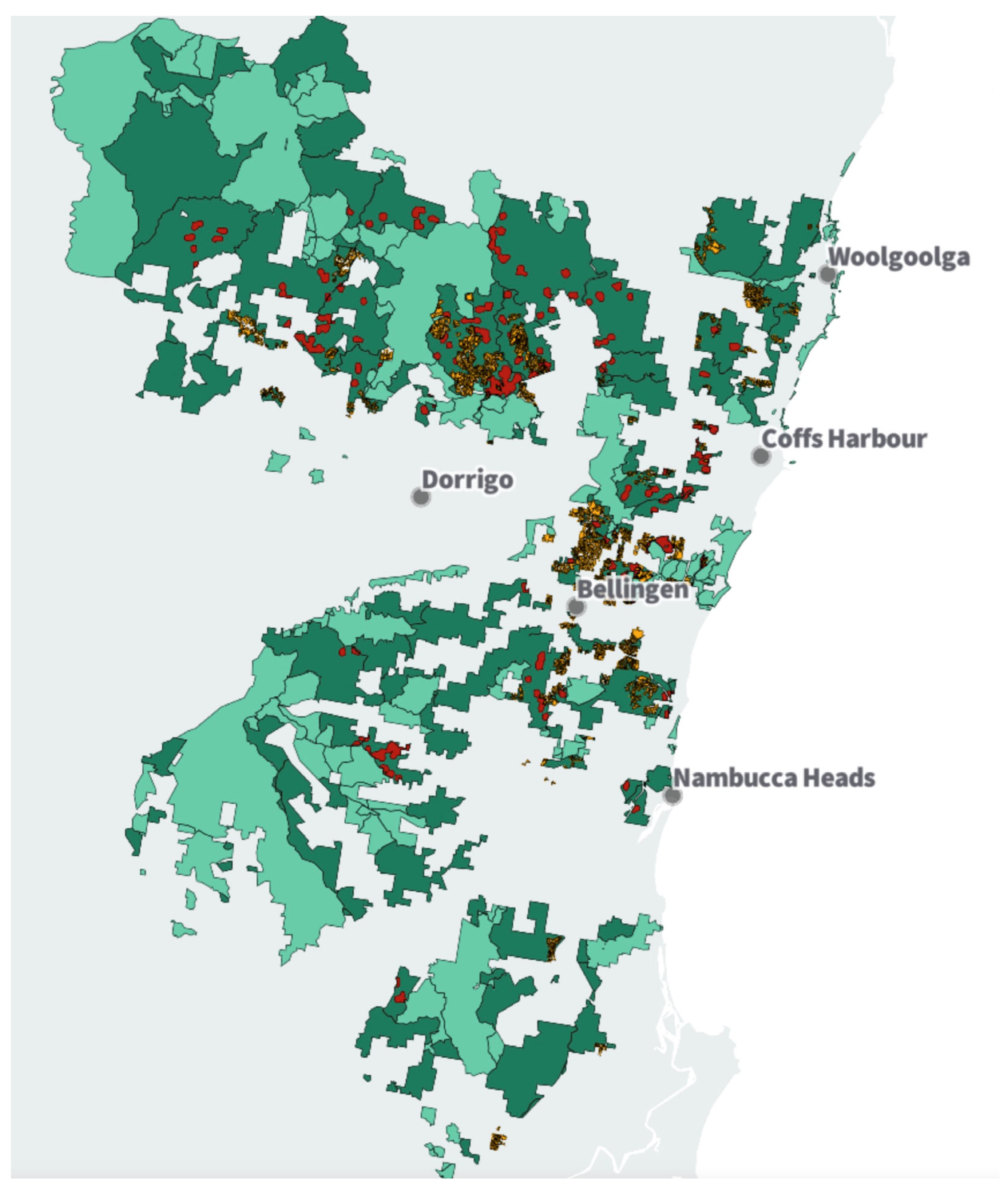
The region lies within the sub-tropical/warm temperate zones, and contains extensive areas of Eucalyptus forest, consisting of a range of species including Flooded gum (E. grandis), Blue gum (E. saligna), Tallowwood (E. microcorys), and Coastal blackbutt (E. pilularis), used by koalas for food. They are also common plantation species, and as a result, both types (natural and planted) are cut during forestry operations. Pockets of sub-tropical rainforest are also found in moister, riparian areas, and suitable habitat extends from the coastal forests to the hinterland [2]. Other arboreal mammals inhabit the forests, including the Vulnerable Squirrel glider (Petaurus norfolcensis, see below) and the Endangered Greater glider (Petauroides volans) [19,20]. Approximately ~176,000 ha of publicly owned state forests are to be joined with existing National Parks to establish a ~315,000 ha nature reserve in the Coffs Coast Region (GKNP), although it is not yet clear if the park will be gazetted only from the State Forests under assessment, or the broader conservation estate as well (Figure 2).

2.2. Data Collection

2.2.1. Original Trees and Forest Remnants

Data collection, following previously published methods, sought to confirm the assertion that the hardwood plantations of Tuckers Nob contain original forest and native vegetation [2]. Original trees (an individual specimen in existence before plantation establishment, either as an isolated example or within a larger cohort of trees) and remnants (a patch of trees that existed before plantation establishment) were identified using historical aerial photography from the NSW Historical Imagery database [21]. Ground control points (GCPs) that were persistent over time, such as boundaries and buildings, were identified [22], and elevation data for the selected GCPs were derived from governmental sources [21,23]. Together, these images and data were used to create ortho-mosaics of the study area to enable desktop spatial analysis and field study. More contemporary imagery was also used, sourced from the NSW Government online spatial service SIX Maps [24]. SIX Maps is employed by NSW Government agencies and was adopted by this research project to enable the generation of data consistent with agency approaches. See Table 1.
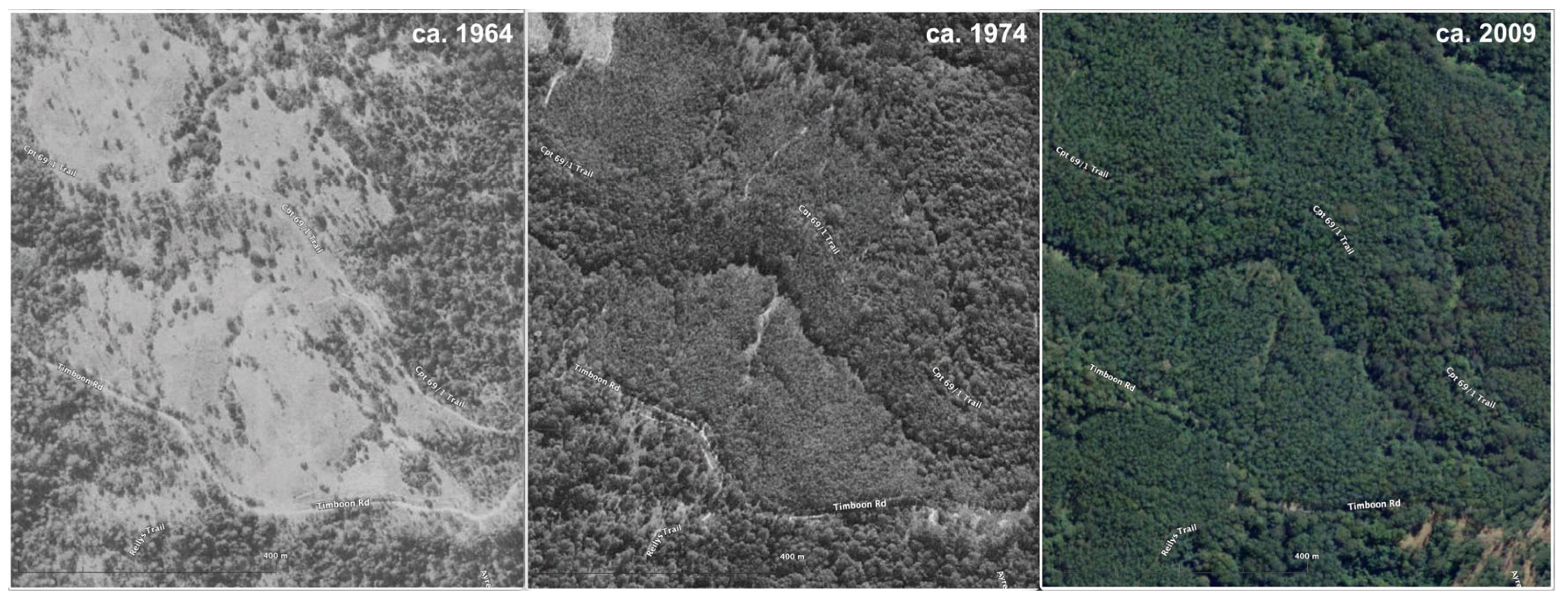
Additional imagery of the specific areas under investigation was created in QGIS (3.36.3—Maidenhead) using the function Save Map as Image, with the coordinate reference system (CRS) set for EPSG 28,356—GDA/MGA zone 56, and imported into Google Earth Pro (GEP) (Figure 3).
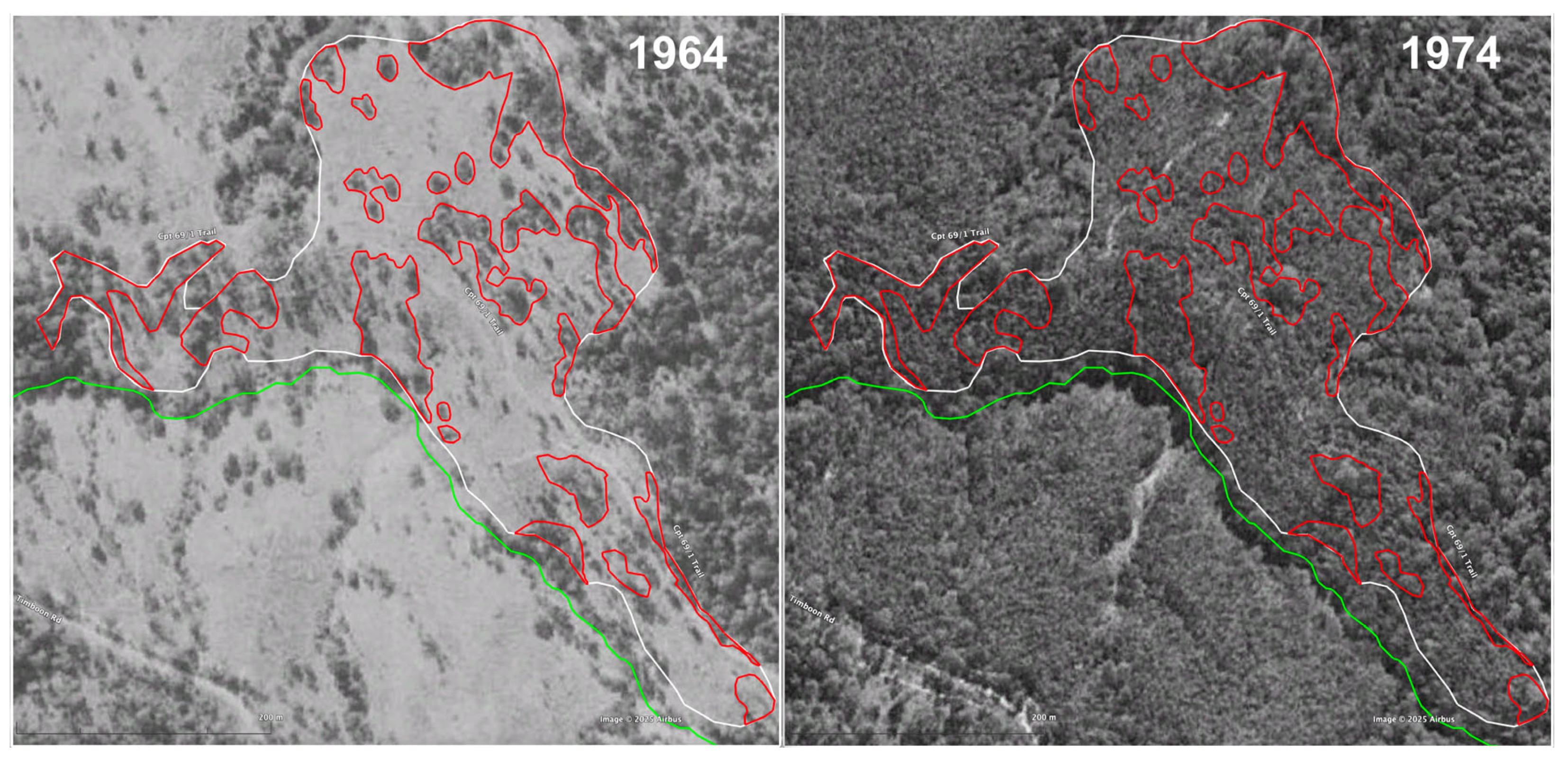
Shape files of the areas zoned plantation from FCNSW were also imported into GEP and compared to the relevant time-sequence imagery before and after plantation establishment to identify surviving original forest. Areas of interest (polygons) of original forest were created in a .kmz file format and added as a further layer, based on canopy differentiation from the more uniform plantation. These were delineated by following the plantation boundary, or the authorized/operational area boundary, and excluding areas set aside within the draft harvest plan operational map (HPOM); delineation was to the outermost edge of any boundary line, unless marked by FCNSW (Figure 4).
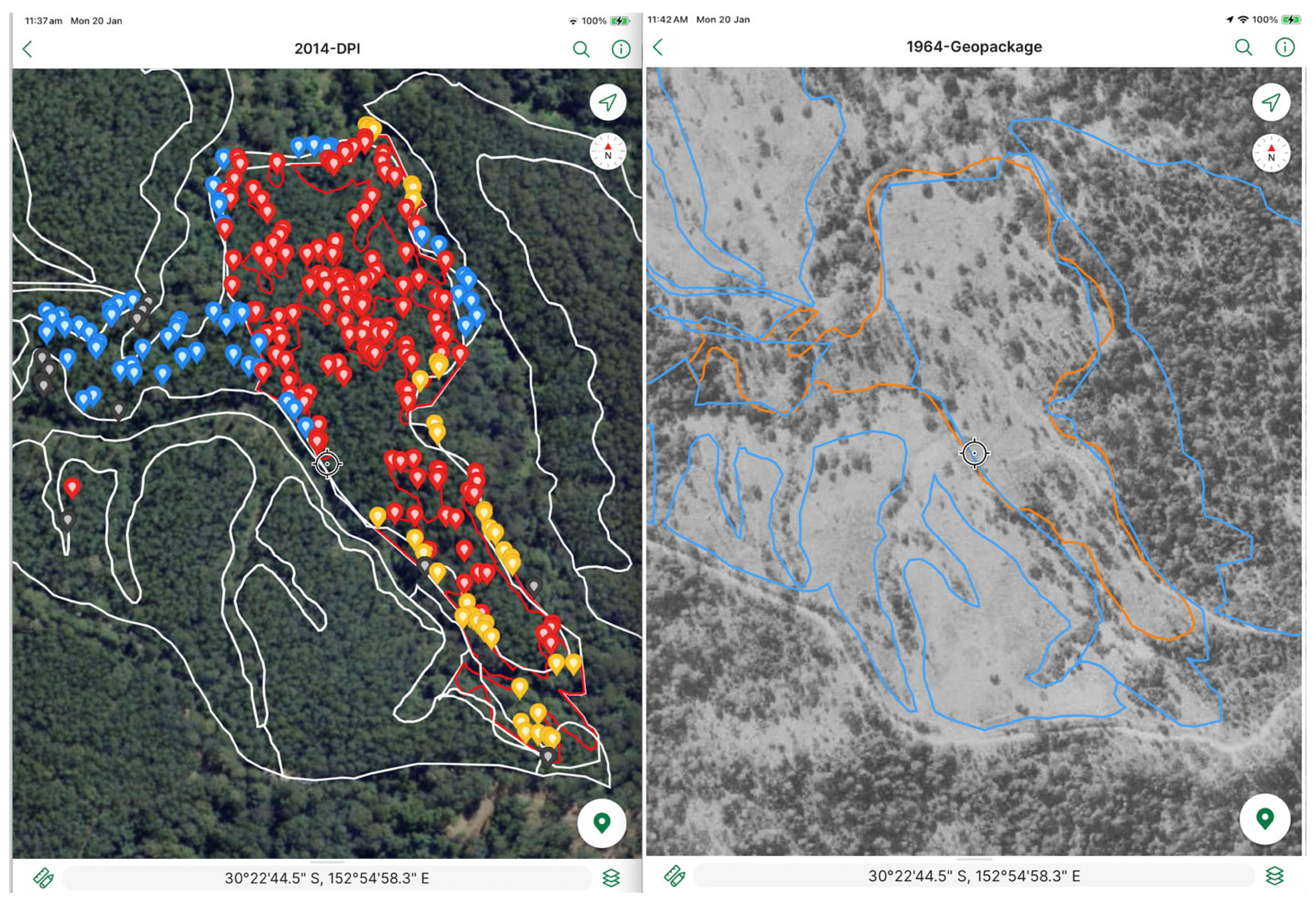
Georeferenced images suitable for field use were generated in QGIS and imported into a tablet with GNSS (global navigation satellite system) compatibility as base layers (maps) using the Avenza app Maps Plus Legacy [25]. Additionally, contemporary imagery in higher resolution from the commercial spatial service provider, Nearmap [26] was also used to enable navigation in the field. The polygons of the remnant areas delineated in GEP were added as a layer onto the base image in the .kmz format. Location accuracy of the tablet was enhanced using a Bluetooth receiver (Garmin GLO 2—GPS and GLONASS, Olathe, KS, USA (navigation system from Russia) compatible). Individual trees and remnant forest were then identified on the ground, and photographic records were collected using the camera function on the tablet, also employing the enhanced accuracy of the receiver, and imported into the app (Figure 5).
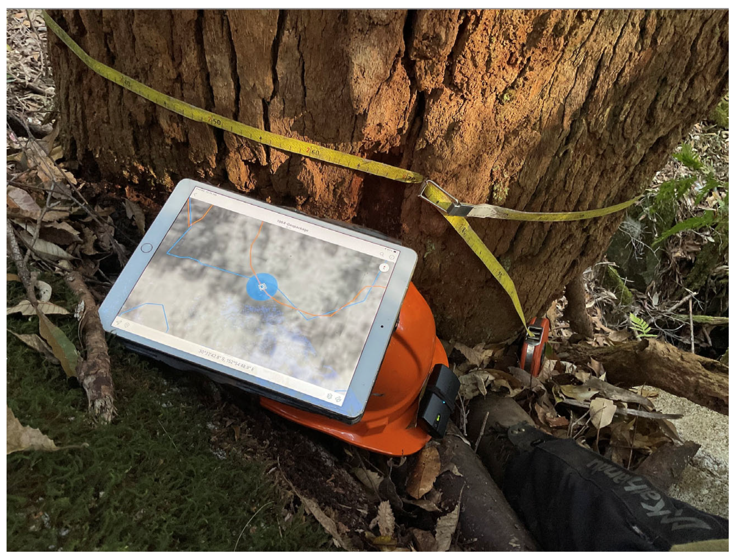
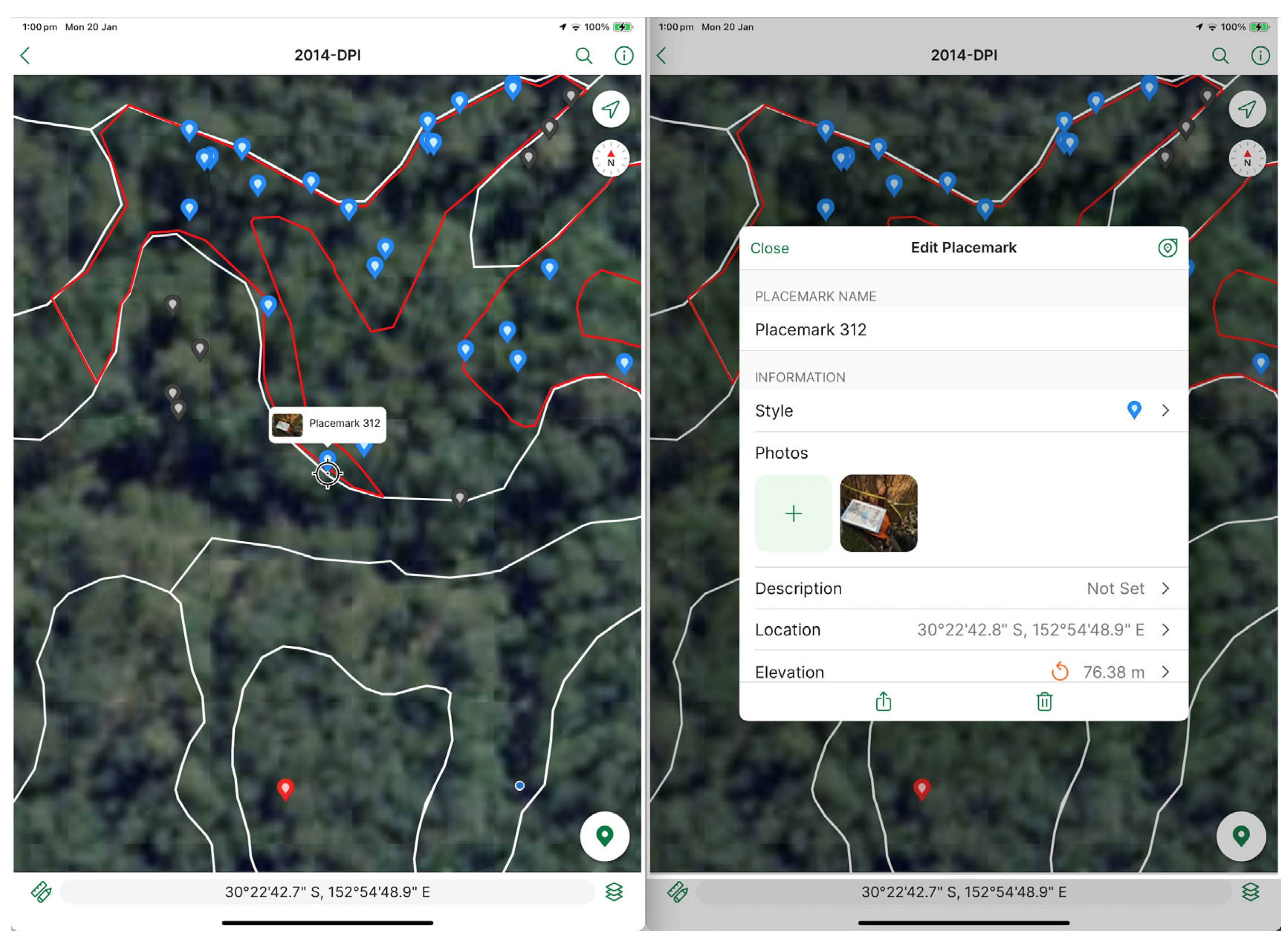
A ground-based survey of the study area was conducted by citizen scientists, under the supervision of the primary investigator, between 4 May 2024 and 14 January 2025. Native forest trees (i.e., members of the Eucalyptus genus growing on drier, more exposed sites such as ridgelines) and rainforest trees (largely found in wetter, more secluded locations such as gullies) were both recorded. Photographs were captured in the field using two tablets: the first to record the image of the tree, the second to locate the tree on the aerial photography. This second tablet was placed next to the receiver, at the base of the tree, with the historical photography and coordinates displayed; a tape measurement showing circumference at stump height over bark (CSHOB) was also included. Together, these formed the basis of the record captured by the first tablet, which was included on the basemap in the Avenza app, using the function Plot Photos (Figure 6 and Figure 7).
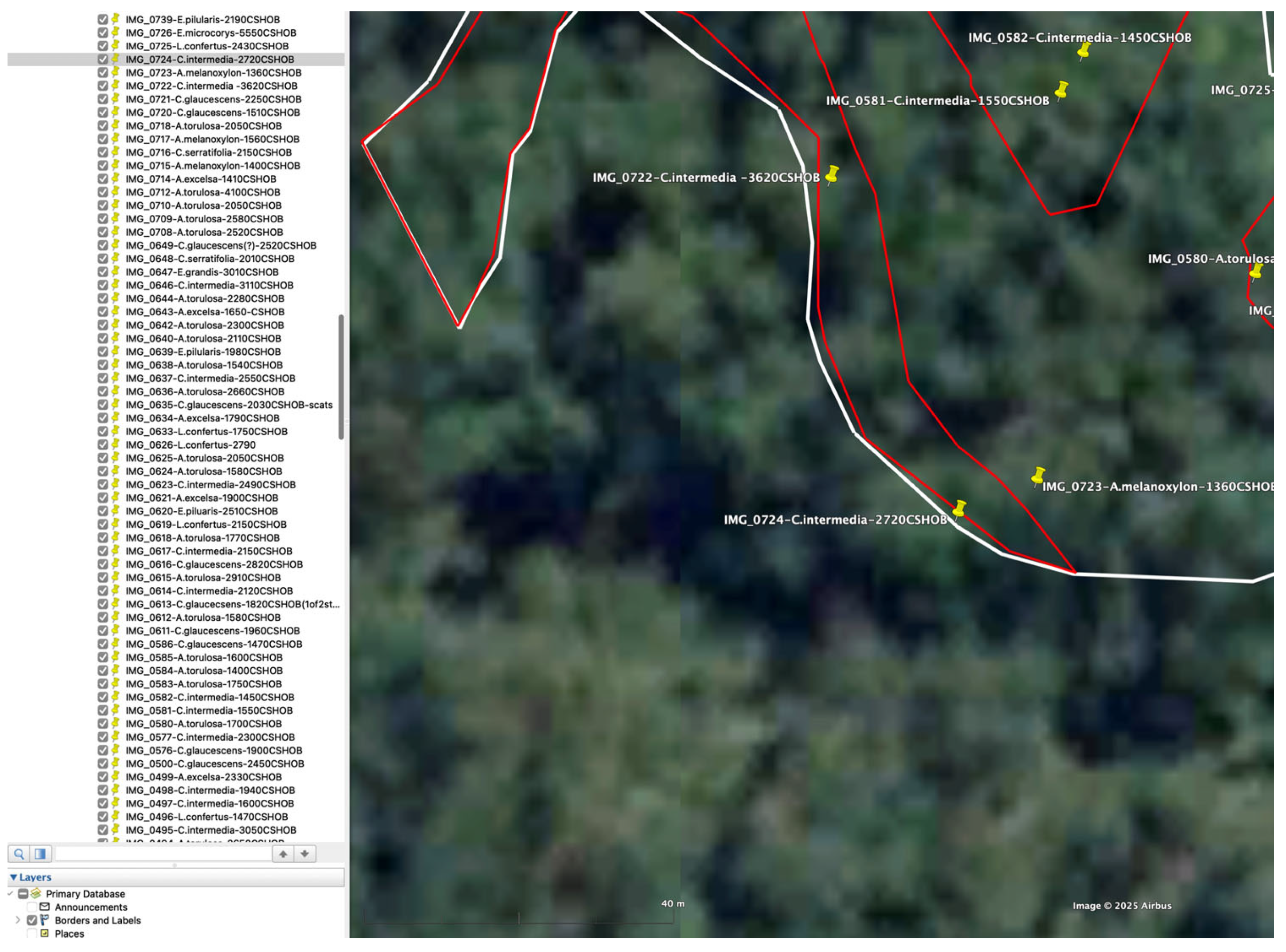
Coordinates from both devices were cross-checked. Rainforest trees under 1500 mm in circumference were generally not recorded, unless uncommon (e.g., Ringwood/Aniseed myrtle Syzygium anisatum) or an important exemplar of native vegetation in a given location. This approach was also applied to Forest oak (Allocasuarina torulosa) and Pink bloodwood (Corymbia intermedia), both non-plantation species, found on the margins of native forest and rainforest. Measurements for Eucalyptus spp. were generally over 2500 mm CSHOB; records were taken of eucalypt species with smaller circumferences if they were part of a larger remnant or an individual, non-plantation species within a plantation (i.e., not planted). If identified, plantation tree species were avoided (see caveats below). These images were subsequently exported into GEP, with image number, species (where identifiable), and CSHOB adding to a central database, or record of trees (Figure 8). These were checked against the historical image layers, and the polygons were amended, if necessary, to create a more accurate delineation of the forest remnants. Individual original trees were also plotted. See the Section 3 below.

2.2.2. Koala Records

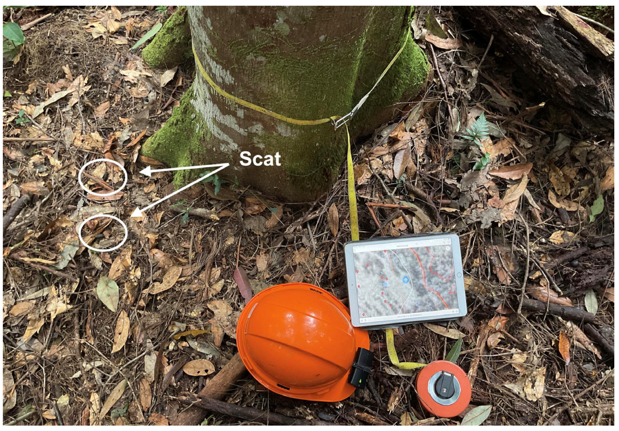
Koala scats located under trees were recorded using the photographic method outlined above (Figure 9), and were collected for independent verification. Collection was undertaken using a sterile container, into which the scat was placed using a twig, or similar, to avoid physical contact, and sealed. Date, time, coordinates, and tree species were written on the label. Samples were kept cool, if retained overnight, or delivered immediately. Verification was undertaken by a local professional company specializing in koala detection and scat identification [27].
Two nights of unmanned aerial vehicle (UAV) or ”drone” surveillance were conducted, 11–12 and 12–13 December 2024 (10 p.m.–5 a.m.), using a DJI Matrice 350 with a thermal camera (H30T sensor) and searchlight. Three areas within the case study were surveyed (142 ha), outlined below:
  • Area 1, partially covering the plantations in compartments 10 and 18 (94 ha);
  • Area 2, encompassing all the plantations in compartment 12 (29 ha);
  • Area 3, including some of the plantations in compartment 8 (19 ha).
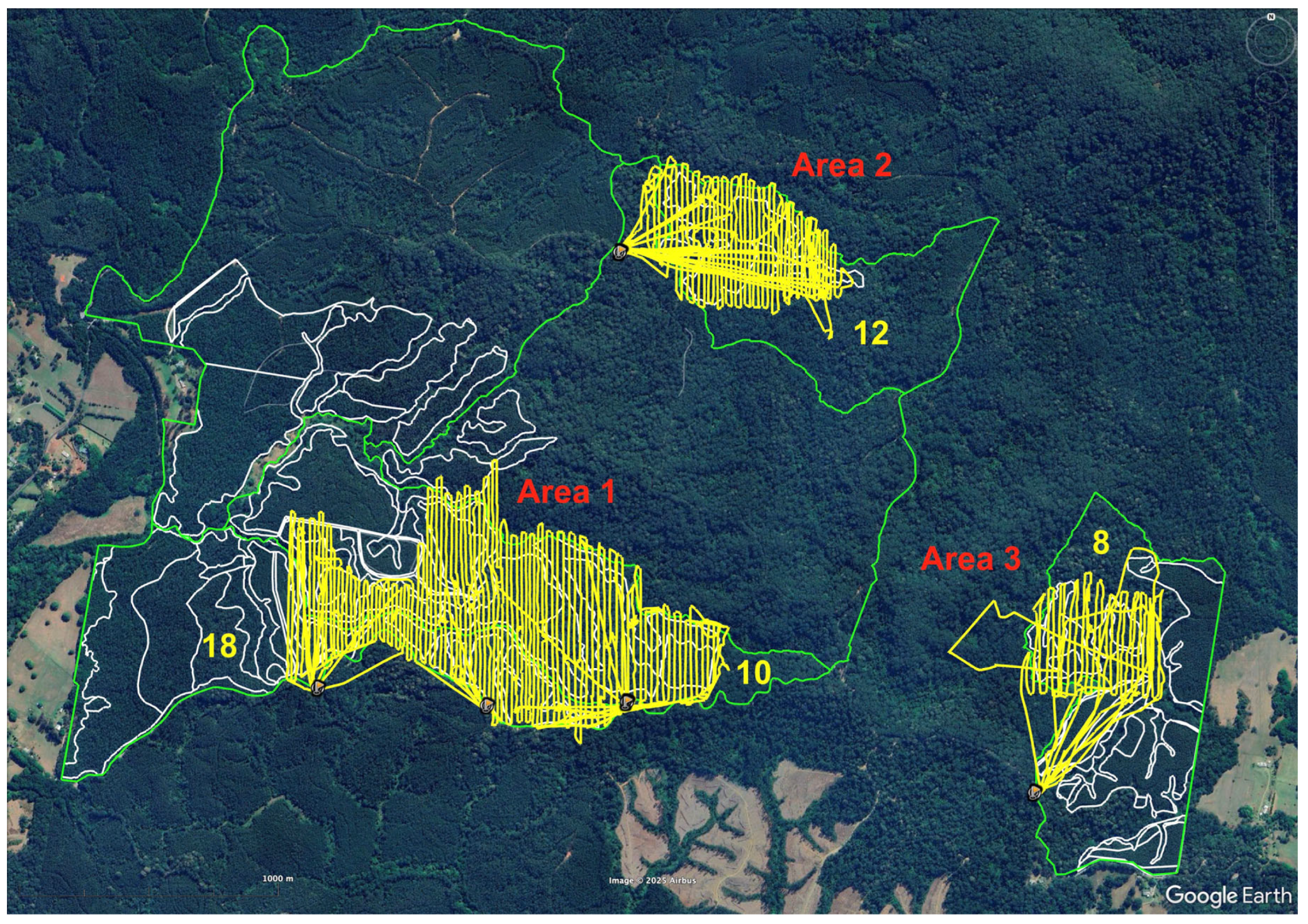
The areas crossed compartment boundaries and were selected for ease of access to achieve the maximum coverage of areas of zoned plantation that had not been subjected to forestry operations since establishment, and that could be flown at the best time–cost efficiency ratio (Figure 10).
Selected areas were flown in a pre-set flightpath to enable spatial accuracy in the field and reduce double-counting of koalas, following best practice methodologies. Transects were flown in straight lines (a lawnmower pattern) with a 40% side-overlap, following canopy topography. Thermal signature detection was made possible by setting a mammalian heat signature above ambient background temperature, which assisted automated detection, followed by manual identification. Immediate verification of sightings was enabled by use of the searchlight, with eye-shine and visual identification confirming each individual koala; this was also filmed using the on-board drone camera, displaying date and time stamps, temperature, coordinates, and distance from the animal, with imagery stored on an SD card. A live feed to a monitor also enabled instant capture of videographic evidence via a second camera (iPhone). A laser range finder logged the koala location in three-dimensional space to an accuracy of 0.5–4 m [28,29,30]. See the Section 3 below.

2.3. Caveats

NSW government data are generally in Lambert projection. This is spatially very accurate, but does not translate well across platforms, particularly for field-based systems that rely on GPS. Data were, therefore, reprojected in QGIS using the function Save Vector Layer as in GDA 94 (Geocentric Datum of Australia 1994: a reference system for defining locations via coordinates) [31].
Locating individual trees under canopy is notoriously difficult. While a GPS receiver can enhance accuracy, it needs to be continually refreshed by returning to open sky and is further impacted by cloudy weather and steep terrain. Consequently, the accuracy of records can vary between 5 and 15 meters, and at worst, 20 meters. This is ameliorated somewhat by the delineation of polygons where patches of remnant forest exist, and post-logging verification of removals, which occur after the loss of canopy through clearing. This is the main reason for mapping, measuring, and photographing trees before logging commences. Trees with a CSHOB of less than 1500 mm (unless significant, such as an uncommon species) and non-original (i.e., in-planted) trees were not recorded. Rainforest trees are not always easily identified, and the researchers accept that some may have been misidentified. However, it should be noted that forestry operations in rainforests were ended in NSW in 1982 [32]; the intention behind collecting these records was to identify them as rainforest and ensure they were not removed. Some plantation species may be included in records. Generally, records were not collected for plantation trees. However, some larger trees were recorded if the historical photography showed the presence of a larger-canopy tree, or if the imagery was unclear, but the individual trees were larger than those surrounding them, and therefore potentially of an older, original cohort. Again, the motivation was to ensure original trees were not removed. A 10% margin of error of target plantation species (i.e., species listed on plantation records as tree species used during establishment of the plantation, and possibly actual plantation trees) is accepted; however, it should be noted that native trees of the same species (i.e., not planted) are also present throughout plantation areas.
It needs to be stressed here that while spatial inventories such as the National Vegetation Information System (NVIS) provide key data informing the understanding of Australia’s vegetation types, policies, and reporting [33], they are not exhaustive and rely in some instances on aerial photographic interpretation from the past at resolutions much coarser than technology can deliver today. The process of identifying, delineating, and verifying remnants described here was undertaken because there were no spatial records for these areas.
Some koala scats were collected during the course of this research. All scats, and/or scat collections were recorded on video. Where there was a discrepancy between the coordinates of the video recording and those of the tree record (i.e., photographic record), the tree record was used. Absolute drone coordinates have been converted into derived point data. A margin of error of approximately 10 m is accepted. Unclear sightings were confirmed via thermal signature and night-vision imagery. There were minor variations in the source methodologies used to inform the drone survey, which is to be expected in an emerging technology; the default approach adopted was consistent with NSW guidelines [28]. It is emphasized here that the survey was not to undertake any larger, landscape-level population study, or draw any such conclusions, but rather to provide evidence of the existence of koalas in areas zoned plantation and to make the case for further investigation and conservation strategy development. While every care was taken to avoid double-counting of koalas via the drone survey, and the authors are confident each individual captured using the camera was unique, this cannot be said for scat samples.
The phrase “area zoned plantation” is used in this manuscript as the concept of plantation in NSW is debateable, both in terms of boundaries (plantable area, authorized plantation, general, and operational) and zonings—Forest Management Zones (FMZ5 management, other management, FMZ6 for softwoods), as well as definitions (which include native forest, silvicultural regrowth, seeded, planted, and unplanted natural regeneration). The phrase area zoned plantation is used here to generally refer to areas likely to be subjected to forestry operations.
The degree of precision of the ortho-mosaics generated from historical aerial photography may not always be absolute due to flaws in base imagery, such as scratches or spots, and changes to ground controls (such as boundaries). In cases of large batch image processing, this can lead to compounding errors [34]. This was not a problem here as few images were involved; however, the authors have now created imagery for the entire State Forest of the proposed GKNP, and this involved hundreds of images. Errors can be offset by ground-based verification, which was central to this project as part of the collection of tree data. However, the cost in time (and money) associated with the creation of georeferenced imagery may preclude the use of tree-date collection. Here, automated processes, which are now maturing and producing accurate results, may be a consideration in the future [35]. Such processes may be applicable to individual trees as well. Whatever the solution to the time–labour cost, FCNSW should consider allocating its own resources to this work rather than outsourcing it to the scientific community and citizen scientists.

3. Results

3.1. Remnant Forest and Original Trees

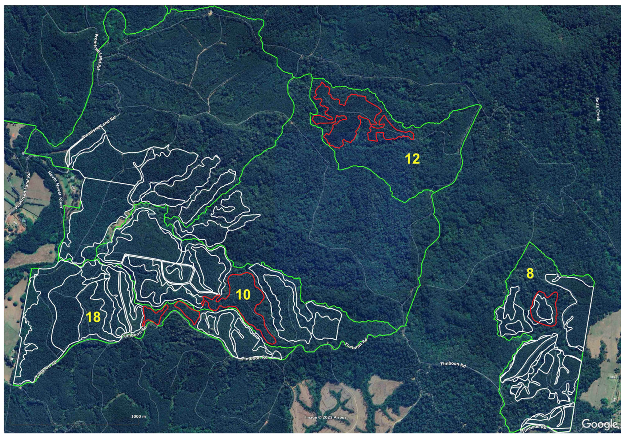
Seven plantation sub-units within the area zoned plantation in the case study area were investigated. Sub-units have their origins in the species selected for planting, as a result of boundary reconfigurations, or due to other reasons. These totaled 30.19 ha and were comprehensively surveyed for remnant forest areas and non-plantation trees (Figure 11). The project was too short, and the planned operations too extensive, to allow for a complete survey of all areas zoned plantation.
These contained 49 remnants, totaling 6.37 ha. and 438 non-plantation trees, as well as some individual habitat trees, although trees were mostly contained within remnants. There were 17 trees over 4 m in circumference, 64 over 3 m, and 188 over 2.5 m. See Table 2 below and the Supplementary Materials.

3.2. Koala Scats and Sightings

There were approximately 75 records for koalas in the NSW Government SEED database for Tuckers Nob SF (natural forest and zoned plantation) at the commencement of this research project. The sightings of koalas adjacent to compartments 26–27 during forestry operations 2023–2024, and the decision to place compartments 8–18 on the operations schedule where fresh scats were found by local residents, supported the view that the areas zoned plantation might contain more koalas than the records suggested.
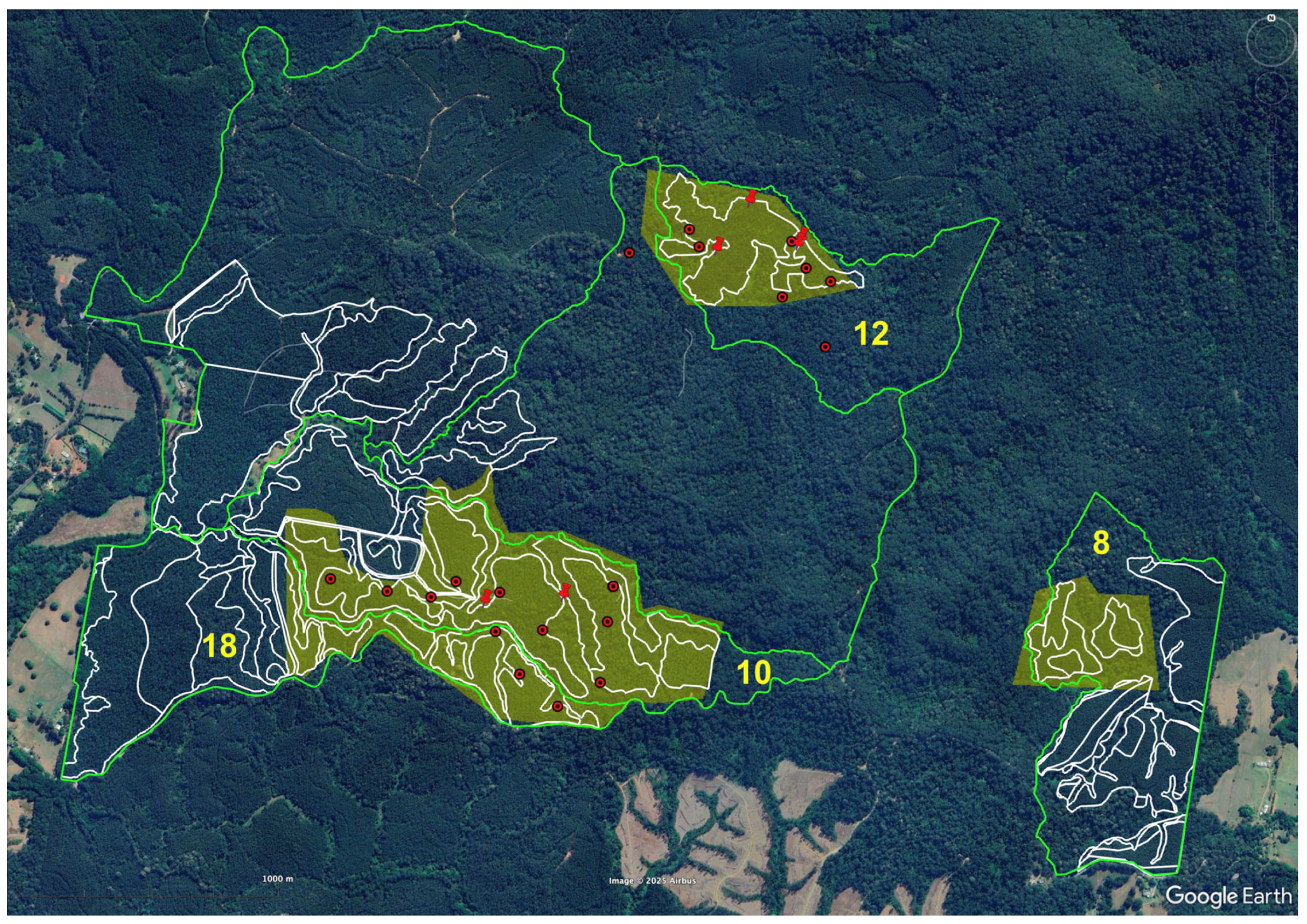
Investigations resulted in six new scat records and 19 sightings in only 142 ha (Figure 12). Two additional sightings were in nearby areas zoned native forest. See Table 1 above and the Supplementary Materials. There were no koalas located in compartment 8, which nevertheless contained two glider species—Squirrel glider (Petaurus norfolcensis) listed as Vulnerable in NSW [19], and Feathertail glider (Acrobates pygmaeus).

4. Discussion

As Table 1 indicates, ground surveys within the 30.19 ha of planned forestry operations in Tuckers Nob SF revealed 438 trees and 49 remnant forest areas. Of the 142 ha zoned plantation surveyed as part of the aerial drone research, koala numbers were at least on a par with, and in some instances (e.g., compartment 12) may even exceed, some of the native forest currently under assessment for inclusion in the proposed park. Given the extent of native vegetation and the numbers of koalas, the areas investigated may need to be reassessed as to their suitability for wood production.
There seems to be an association between koalas, original trees, and remnant forest. See the Supplementary Materials for more details. It should also be noted that the presence of koalas on the edge of plantations indicates that koalas are likely to use a diverse mosaic of forest ages, and, given the evidence of the number of scats under rainforest trees, an interest in rainforest species. The regular sighting of koalas near the intersection between remnant and plantation or re-growth has also been observed in Victorian Blue gum plantations [37]. While Koalas are known to browse on Forest oak in the region [38], the sighting of this during the drone survey is uncommon and warrants further research into the importance of this tree for local koala populations. The disappearance of koalas in the area surveyed in compartment 8 and the low numbers in compartment 18 are possibly associated with recent clearing; by comparison, 10 and 12, which are less disturbed, indicate the importance of retaining plantation habitat.
Involvement of citizen scientists in koala and koala habitat monitoring is to be encouraged. It allows citizens to be part of discussions and have a say in important policy issues such as natural resource management and reserve design. The way in which these management practices are understood by government and industry—as well as the academy, in terms of how it designs and deploys field research—is influenced by engaging citizens in processes of knowledge development. The collaboration between researchers and members of the community in partnership serves as a check on the power of governmental institution systems regarding natural resource management. Public participation in management is, therefore, not just about making sure people are “heard”; it may even increase the effectiveness of actions taken.
However, the relatively small scale of this research makes it difficult to be emphatic about any of the findings. The level of work also required, even for this small study, makes finding economies of scale imperative. Simpler, more user-friendly tools that can be deployed with less need for detailed training would make data collection easier [39]. Simplicity notwithstanding, it is important to emphasize that community-based research exists to complement, not replace, institutional capacity. The steps taken by the agency to engage with community stakeholders in this regard are a step in the right direction. Subsequently, FCNSW needs to allocate more resources to identifying, mapping, and protecting the conservation values in its plantation areas. However, there is a long way to go; very little of the remnant forest within the NSW hardwood plantation estate authorized for forestry has been mapped.
It is clear that further survey work across the plantations within the proposed GKNP needs to be undertaken as a matter of urgency to determine the extent to which the findings of this research are borne out in other areas zoned plantation. All plantation areas with high koala habitat value may need to be incorporated into the proposed park. A moratorium on forestry operations pending the outcome of additional surveys is, therefore, also required to be instated. So too is a review of current plantation management, particularly the annexation of new areas as plantation, and the clearing and conversion of native vegetation in the plantation estate. The persistent classification of native vegetation inside areas zoned plantation when they are clearly not is a further problem; the possibility exists that these may be converted at a later date.

5. Conclusions

This paper investigated the assertion that hardwood plantations may increase the value of koala habitat in metapopulations of the GKNP and found that the value of plantations as koala habitat rests on the extent of the koala habitat within them and the degree of disturbance experienced. Our results indicate that koala populations within a plantation are likely to function at a landscape level by using a mosaic of vegetation plots of different ages. As the example of our investigation into the koala habitat in the Tuckers Nob shows, it is of concern that many areas zoned hardwood plantations in NSW are likely plantations in name only, and even if planted, contain very high numbers of original trees, and multiple patches of surviving remnant forest that existed before establishment of the plantations. The older the plantations, the more diverse the species (both planted and surviving), and the higher the number of koalas; the younger, the less diverse and more disturbed, and the lower their numbers.
It is rational that an animal that spends much of its time in trees, obtains most of its water from leaves, and prefers forest areas on fertile soils would find the older plantations of Tuckers Nob, established on previously cleared moist lowland coastal forests and rainforests, attractive. It is essential to take this into consideration during any assessment process and exclude such areas from harvesting until assessments are completed. Given the lack of spatial data for the remnant forest identified in the methodologies outlined above, there is an urgent need to revisit the information base informing conservation strategies and forest management regimes in light of the materials presented here. In the absence of properly funded and executed government surveys, support from academic researchers, citizen scientists, and community groups in such assessments is, therefore, of vital importance and needs to be taken into consideration by government and agencies.
Stakeholders should prioritize defining the term sustainable plantations, otherwise, the risk of the extinction of koalas is exacerbated. How plantations are managed and where these are located in relation to existing koala habitat must be reconsidered. There is significant risk that ongoing plantation forestry operations within the park’s boundary will undermine the integrity of the park and provide a continual source of habitat disturbance, placing additional pressure on koala populations. In such high-conservation-value areas, forestry operations are not the priority. Instead, the management focus should be on conserving koala habitat. Failure to recognize the conservation values of koala habitat within plantations could undermine both the legitimacy and effectiveness of the proposed park as a strategy to protect koalas long-term.

Supplementary Materials

The following supporting information can be downloaded at: https://www.mdpi.com/article/10.3390/wild2040042/s1, Detailed descriptions and figures on the survey results.

Author Contributions

Conceptualization, T.C. and S.C.; methodology, T.C.; software, T.C.; validation, T.C.; formal analysis, T.C. and M.D. (Matt Dell); investigation, T.C. and citizen scientists.; resources, T.C.; data curation, T.C.; writing—original draft preparation, R.S., T.C., F.S., M.D. (Michael Danaher), G.M., I.D.C., and A.M.; writing—review and editing, R.S., T.C., F.S., M.D. (Michael Danaher), G.M., I.D.C., F.C., A.M., and M.D. (Matt Dell); visualization, T.C.; supervision, T.C.; project administration, T.C.; funding acquisition, T.C. All authors have read and agreed to the published version of the manuscript.

Funding

This research received an in-kind contribution from the Bob Brown Foundation to offset the cost of orthorectification of historical aerial photography. Subsequent drone survey work was undertaken by Ripper Corp, with financial support provided by WWF Australia. This research was funded via an internal small grant from Griffith University’s Arts, Education, and Law Group (AUD 8983) with an additional cash contribution of AUD 2000 each from the Law Futures Centre and the Institute for Ethics, Governance, and Law, accounted for via the project Ensuring the sustainability of plantation management—a citizen science approach (protocol 2022/466).

Institutional Review Board Statement

Ethical review and approval for the project was obtained from the Griffith University Human Ethics Research Committee on 11/07/2022, Approval code 2022/466, under the title Ensuring the sustainability of plantation management—a citizen science approach. All drone survey work was undertaken by qualified and authorized staff, in accordance with the recommended NSW Government guidelines [25].

Data Availability Statement

This study’s data can be obtained upon request from Tim Cadman. SIX Maps may be viewed at the following: https://maps.six.nsw.gov.au/ (accessed on 8 August 2025). Unrectified historical imagery may be viewed at the following: https://portal.spatial.nsw.gov.au/portal/apps/webappviewer/index.html?id=f7c215b873864d44bccddda8075238cb (accessed on 8 August 2025). Forest conversion, citizen science training, and koala records may be viewed at the following: https://www.youtube.com/@timcadman5159/playlists (accessed on 8 August 2025).

Acknowledgments

The authors acknowledge the Gumbaynggirr People as the Traditional Custodians of the land where this research focused on. They value the contribution of Elders past, present, and emerging and recognize and respect the cultural heritage and beliefs of Aboriginal people and are committed to honoring the Gumbaynggirr People’s unique cultural and spiritual relationship to the land, rivers, and sea. This paper is based on the results of investigations led by the fourth author, with the support of local community-based citizen scientists, as part of the research project Ensuring the sustainability of plantation management—a citizen science approach (protocol 2022/466).

Conflicts of Interest

The authors declare no conflicts of interest. Author G.M. was employed by the company BrodiMapi LLC. The remaining authors declare that the research was conducted in the absence of any commercial or financial relationships that could be construed as a potential conflict of interest.

References

  1. Department of Agriculture, Water and the Environment. Conservation Advice for Phascolarctos cinereus (Koala) Combined Populations of Queensland, New South Wales and the Australian Capital Territory; Department of Agriculture, Water and the Environment: Canberra, Australia, 2022. [Google Scholar]
  2. Cadman, T.; Schlagloth, R.; Santamaria, F.; Morgan, E.; Clode, D.; Cadman, S. Koalas, Climate, Conservation, and the Community: A Case Study of the Proposed Great Koala National Park, New South Wales, Australia. Int. J. Soc. Qual. 2023, 13, 25–55. [Google Scholar] [CrossRef]
  3. Cahir, F.; Schlagloth, R.; Clark, I.D. The historic importance of the koala in Aboriginal society in New South Wales, Australia: An exploration of the archival record. ab-Orig. J. Indig. Stud. First Nations First Peoples’ Cult. 2020, 3, 172–191. [Google Scholar] [CrossRef]
  4. Cadman, T.; Clode, D. A Home Among the Gum Trees: Will the Great Koala National Park Actually Save Koalas? The Conversation. 2023. Available online: https://theconversation.com/a-home-among-the-gum-trees-will-the-great-koala-national-park-actually-save-koalas-217276 (accessed on 8 August 2025).
  5. Cadman, T.; Macdonald, K.; Morgan, E.; Cadman, S.; Karki, S.; Dell, M.; Barber, G.; Koju, U. Forest conversion and timber certification in the public plantation estate of NSW: Implications at the landscape and policy levels. Land Use Policy 2024, 143, 107179. [Google Scholar] [CrossRef]
  6. Leys, A.J.; Vanclay, J.K. Land-use change conflict arising from plantation forestry expansion: Views across Australian fencelines. Int. For. Rev. 2010, 12, 256–269. [Google Scholar] [CrossRef]
  7. McAlpine, C.A.; Rhodes, J.R.; Callaghan, J.G.; Bowen, M.E.; Lunney, D.; Mitchell, D.L.; Pullar, D.V.; Possingham, H.P. The importance of forest area and configuration relative to local habitat factors for conserving forest mammals: A case study of koalas in Queensland, Australia. Biol. Conserv. 2006, 132, 153–165. [Google Scholar] [CrossRef]
  8. Schlagloth, R.; Golding, B.; Kentish, B.; McGinnis, G.; Clark, I.D.; Cadman, T.; Cahir, F.; Santamaria, F. Koalas–Agents for Change: A case study from regional Victoria. J. Sustain. Educ. 2022, 26, 1–16. Available online: https://www.susted.com/wordpress/?s=koala (accessed on 8 August 2025).
  9. Schlagloth, R.; Santamaria, F.; Golding, B.; Thomson, H. Why is It Important to Use Flagship Species in Community Education? The Koala as a Case Study. Anim. Stud. J. 2018, 7, 127–148. [Google Scholar]
  10. Sequeira, A.M.M.; Roetman, P.E.J.; Daniels, C.B.; Baker, A.K.; Bradshaw, C.J.A. Distribution models for koalas in South Australia using citizen science-collected data. Ecol. Evol. 2014, 4, 2103–2114. [Google Scholar] [CrossRef]
  11. Brown, G.; McAlpine, C.; Rhodes, J.; Lunney, D.; Goldingay, R.; Fielding, K.; Hetherington, S.; Hopkins, M.; Manning, C.; Wood, M.; et al. Assessing the validity of crowdsourced wildlife observations for conservation using public participatory mapping methods. Biol. Conserv. 2018, 227, 141–151. [Google Scholar] [CrossRef]
  12. Hollow, B.; Roetman, P.E.; Walter, M.; Daniels, C.B. Citizen science for policy development: The case of koala management in South Australia. Environ. Sci. Policy 2015, 47, 126–136. [Google Scholar] [CrossRef]
  13. Flower, E.; Jones, D.; Bernede, L. Can citizen science assist in determining koala (Phascolarctos cinereus) presence in a declining population? Animals 2016, 6, 42. [Google Scholar] [CrossRef] [PubMed]
  14. Stenhouse, A.; Roetman, P.; Lewis, M.; Koh, L.P. Koala Counter: Recording citizen scientists’ search paths to improve data quality. Glob. Ecol. Conserv. 2020, 24, e01376. [Google Scholar] [CrossRef]
  15. Dissanayake, R.B.; Stevenson, M.; Allavena, R.; Henning, J. The value of long-term citizen science data for monitoring koala populations. Sci. Rep. 2019, 9, 10037. [Google Scholar] [CrossRef]
  16. Danaher, M.; Schlagloth, R.; Hewson, M.; Geddes, C. One person and a camera: A relatively non-intrusive approach to Koala citizen science. Aust. Zool. 2023, 43, 52–66. [Google Scholar] [CrossRef]
  17. Cleary, G. Welcome to the anatomy of the great koala count. Nat. N. S. W. 2013, 57, 5–7. [Google Scholar]
  18. Predavec, M.; Lunney, D.; Shannon, I.; Lemon, J.; Sonawane, I.; Crowther, M. Using repeat citizen science surveys of koalas to assess their population trend in the north-west of New South Wales: Scale matters. Aust. Mammal. 2017, 40, 47–57. [Google Scholar] [CrossRef]
  19. NSW Government (Office of Environment and Heritage). Squirrel Glider Profile. 2024. Available online: https://threatenedspecies.bionet.nsw.gov.au/profile?id=10604 (accessed on 8 August 2025).
  20. NSW Government (Office of Environment and Heritage). Southern Greater Glider. 2024. Available online: https://threatenedspecies.bionet.nsw.gov.au/profile?id=20306 (accessed on 8 August 2025).
  21. Government of NSW Spatial Services. NSW Elevation Data Service. 2023. Available online: https://portal.spatial.nsw.gov.au/portal/apps/webappviewer/index.html?id=437c0697e6524d8ebf10ad0d915bc219 (accessed on 8 August 2025).
  22. Briggs, J.; Prahalad, V.; Sharples, C.; Dell, M. An Adaptive Multiple-Criteria Decision Analysis Approach to Mapping Regional-Scale Post-Colonisation Changes to the Tidal Wetlands of Kanamaluka/River Tamar, Tasmania, Australia. In Estuaries and Coasts; Springer: Berlin/Heidelberg, Germany, 2025; Volume 48, pp. 1–19. [Google Scholar]
  23. Intergovernmental Committee on Surveying and Mapping (Undated). Elvis—Elevation and Depth—Foundation Spatial Data, Undated. Available online: https://elevation.fsdf.org.au (accessed on 8 August 2025).
  24. Government of NSW Spatial Services. Six Maps. 2023. Available online: https://maps.six.nsw.gov.au (accessed on 8 August 2025).
  25. Avenza Systems Inc. System Software Company. 2025. Available online: www.avenza.com (accessed on 8 August 2025).
  26. Nearmap. Turn Location Data into Insightful Answers. 2025. Available online: www.nearmap.com/au (accessed on 8 August 2025).
  27. Canines for Wildlife. Conservation Detection Dogs. 2025. Available online: https://caninesforwildlife.com/ (accessed on 8 August 2025).
  28. State of NSW and Department of Planning Environment Koala (Phascolarctos cinereus) Biodiversity Assessment Method Survey Guide Environment Heritage Group Department of Planning Environment Parramatta NSW. 2022. Available online: https://www2.environment.nsw.gov.au/publications/koala-phascolarctos-cinereus-biodiversity-assessment-method-survey-guide (accessed on 8 August 2025).
  29. Ryan, S.A.; Southwell, D.M.; Beranek, C.T.; Clulow, J.; Jordan, N.R.; Witt, R.R. Estimating the landscape-scale abundance of an arboreal folivore using thermal imaging drones and binomial N-mixture modelling. Biol. Conserv. 2025, 309, 111207. [Google Scholar] [CrossRef]
  30. Beranek, C.T.; Roff, A.; Denholm, B.; Howell, L.G.; Witt, R.R. Trialling a real-time drone detection and validation protocol for the koala (Phascolarctos cinereus). Aust. Mammal. 2020, 43, 260–264. [Google Scholar] [CrossRef]
  31. Geocentric Datum of Australia. The Australian Geospatial Reference System. Intergovernmental Committee on Survey and Mapping. 1994. Available online: https://www.icsm.gov.au/datum/geocentric-datum-australia-1994-gda94. (accessed on 10 August 2024).
  32. Glascott, J. From the Archives, 1982: Conservationists Win the Rainforest Battle; Sydney Morning Herald: North Sydney, NSW, Australia, 1982; Available online: https://www.smh.com.au/environment/conservation/from-the-archives-1982-conservationists-win-the-rainforest-battle-20221017-p5bqgk.html (accessed on 22 August 2025).
  33. Australian Government Department of Climate Change, Energy, the Environment and Water, National Vegetation Information System (NVIS). 2025. Available online: https://www.dcceew.gov.au/environment/environment-information-australia/national-vegetation-information-system (accessed on 8 August 2025).
  34. Walstra, J.; Chandler, J.; Dixon, N.; Wackrow, R. Evaluation of the controls affecting the quality of spatial data derived from historical aerial photographs. Earth Surf. Process Landf. 2011, 36, 853–863. [Google Scholar] [CrossRef]
  35. Kim, J.S.; Miller, C.C.; Bethel, J. Automated georeferencing of historic aerial photography. J. Terr. Obs. 2010, 2, 6. [Google Scholar]
  36. FCNSW Forestry Corporation of NSW Hardwood Forests Division Draft Plantation Harvest Map Tuckers Nob State Forest Compartments TCK_008_10-_11_12_17_18, 2024. Crown Copyright 2013. Available online: https://aws-codestar-ap-southeast-2-712553626359-plans-webapp-files.s3.ap-southeast-2.amazonaws.com/HPRP_TUCKERS_NOB_Plantation_8_10_11_12_17_18_Locality.pdf (accessed on 8 August 2025).
  37. Schlagloth, R.; Santamaria, F.; Mitchell, D.; Rhodes, J. Use of Blue Gum Plantations by Koalas—A Report to Stakeholders in the Plantation Industry; Australian Koala Foundation: Brisbane, Australia, 2008. [Google Scholar]
  38. Smith, A.P.; Pile, J. Koala density, habitat, conservation, and response to logging in eucalyptus forest; a review and critical evaluation of call monitoring. Aust. Zool. 2024, 44, 44–76. [Google Scholar] [CrossRef]
  39. Lemmens, R.; Antoniou, V.; Hummer, P.; Potsiou, C. Citizen science in the digital world of apps. In The Science of Citizen Science; Springer: Berlin/Heidelberg, Germany, 2021; pp. 461–474. [Google Scholar]
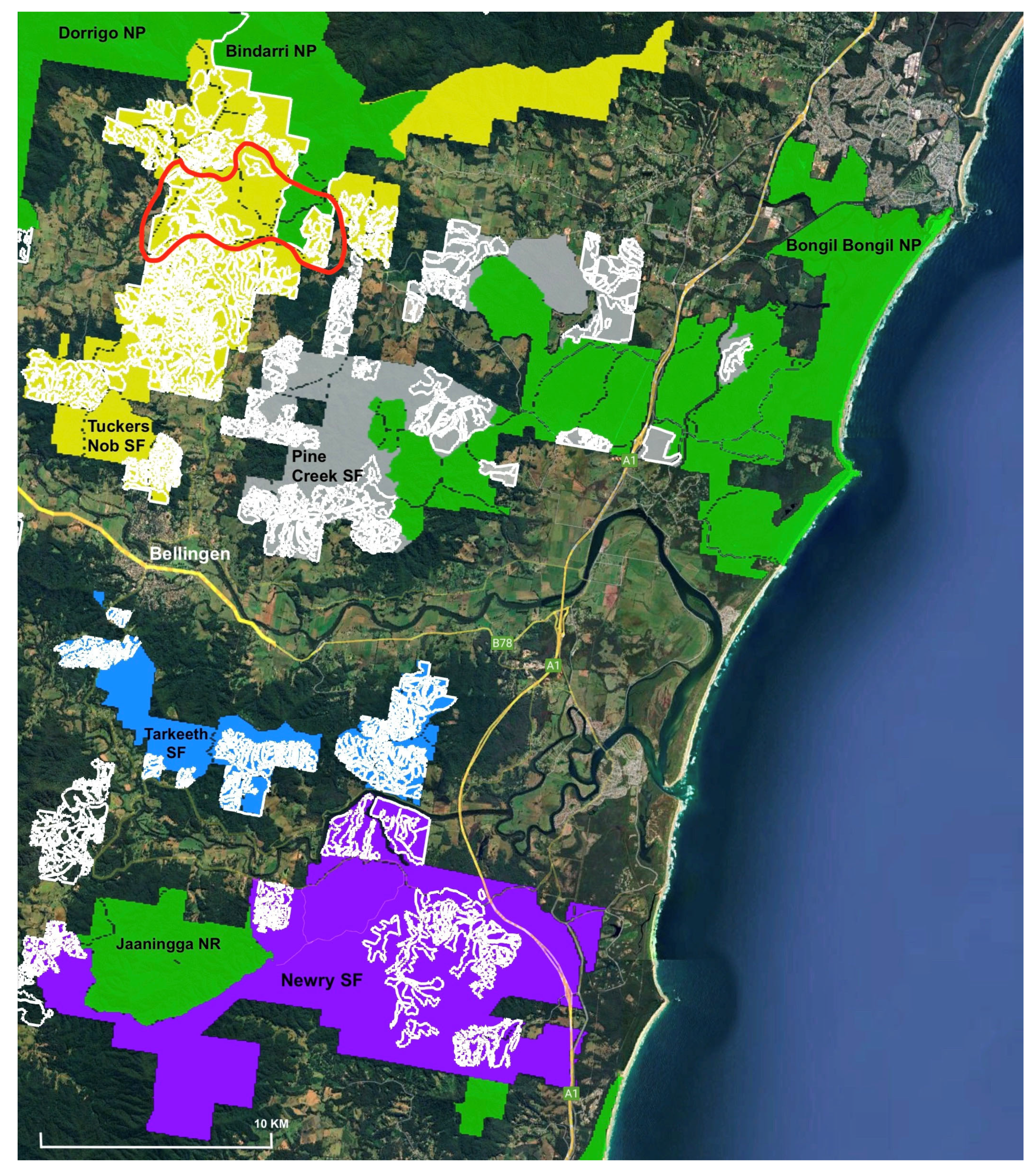
Figure 1. Location map. Areas zoned plantation are outlined in white. The study area is outlined in red. Sources: NSW Government data; imagery copyright Google; Airbus 2025.
Wild 02 00042 g001
Figure 2. Proposed Great Koala National Park—Mid North Coast of NSW. Sources: creative commons imagery using NSW Government data provided by the authors and generated via OpenMapTiles and Open Street Map [2,4]. Light green indicates existing national parks; dark green, state forests; red, koala hubs; yellow, plantations.
Wild 02 00042 g002
Figure 3. Close-up of forest cover within the survey area 1964–2009, imported into Google Earth Pro (NSW Government; base layer road legends copyright Google and Airbus, 2024).
Wild 02 00042 g003
Figure 4. Remnant forest pre- and post-establishment (red polygons) inside an area zoned plantation (white polygon) within compartment 10 (green polygon) of Tuckers Nob SF 1964–1974 (NSW Government; base layer road legends copyright Google and Airbus, 2024).
Wild 02 00042 g004
Figure 5. Screenshot of tablet as illustrative example of record of trees captured in Avenza app using SIX Maps and historical photography (NSW Government). Notes: (1) The white polygons in the image to the left are the sub-units within the plantation identified for wood production. (2) The red dots are original trees in the plantation sub-unit of Figure 4 above. (3) The yellow dots are trees excluded from this sub-unit as a consequence of boundary changes (some have been set aside from wood production, others are now in different plantation sub-units as a consequence of boundary changes during the planning process). (4) Blue dots are trees annexed into the reconfigured plantation sub-unit. (5) The image to the right is from 1964, used to inform field verification. (6) The blue polygons are from 2021. (7) The orange polygon is the current configuration—this demonstrates the continually shifting delineation of what is zoned within plantation areas for wood production.
Wild 02 00042 g005
Figure 6. Photographic record of original tree (Pink bloodwood Corymbia intermedia, 2720 mm CSHOB), showing second tablet with historical imagery, GPS receiver, and tape measure.
Wild 02 00042 g006
Figure 7. Record of tree on the Avenza app: on the left, as a placemark; on the right, with metadata displayed showing the tree’s location on the map and the actual tree (NSW Government).
Wild 02 00042 g007
Figure 8. Screenshot of individual tree (C. intermedia, 2720 mm CSHOB—middle of image) entered on central database with other records (imagery copyright Google, Airbus, 2025; NSW Government).
Wild 02 00042 g008
Figure 9. Record of tree (Cryptocaria glaucescens 2030 mm CSHOB) with koala scats in situ.
Wild 02 00042 g009
Figure 10. Study area surveyed during this research (imagery copyright Google, Airbus 2025; NSW Government). Notes: (1) Areas numbered in red. (2) Compartments numbered in yellow. (3) Compartment boundaries (green polygons). (4) Plantation sub-units (white polygons). (5) Survey transects (yellow lines). (6) Drone pilot locations (orange flags).
Wild 02 00042 g010
Figure 11. All areas zoned plantation currently scheduled for forestry operations (imagery copyright Google, Airbus 2025; NSW Government). Notes: (1) Red polygons (individual sub-units surveyed). (2) White polygons (areas zoned plantation); green polygons (compartment boundaries). (3) Compartment numbers in yellow. (4) Configuration of plantation boundaries changed within compartment 8 during survey period; only those areas within the red polygon were included in the results of this study.
Wild 02 00042 g011
Figure 12. New koala records for compartments 8–18 in Tuckers Nob (imagery copyright Google, Airbus 2025; NSW Government). Notes: (1) green polygons—compartment boundary; (2) yellow numbers—compartment number; (3) white polygons—areas zoned plantation; (4) yellow semi-transparent polygons—surveyed at time of writing; (5) red dot—aerial sighting; (6) red pin—scat record.
Wild 02 00042 g012
Table 1. List of historical aerial image data used in this research.
SourceName DateScaleResolution (dpi)
NSW Historical Imagery1279_09_249.jp2.jpeg12/8/19641:40,000600
NSW Historical Imagery1279_09_250.jp2.jpeg12/8/19641:40,000600
NSW Historical Imagery1279_09_251.jp2.jpeg12/8/19641:40,000600
NSW Historical Imagery1279_10_263.jp2.jpeg12/8/19641:40,000600
NSW Historical Imagery1279_10_264.jp2.jpeg12/8/19641:40,000600
NSW Historical Imagery1279_10_265.jp2.jpeg12/8/19641:40,000600
NSW Historical Imagery2256_07_117.jp2.jpeg18/8/19741:40,000600
NSW Historical Imagery2256_07_118.jp2.jpeg18/8/19741:40,000600
NSW Historical Imagery3405_07_031.jp2.jpeg2/9/19841:40,000600
NSW Historical Imagery3405_07_030.jp2.jpeg2/9/19841:40,000600
NSW Historical Imagery4197_11_071.jp2.jpeg17/5/19941:25,000600
NSW Historical Imagery4197_11_072.jp2.jpeg17/5/19941:25,000600
NSW Historical Imagery4197_11_073.jp2.jpeg17/5/19941:25,000600
SIX MapsDorrigo_2009_4111/9/20091:566972
SIX Mapsl8olps_nsw_2014_dbal01/1/20141:566972
Table 2. Summary data of remnants, trees, and koalas.
CompartmentYear
Established
Area (ha)Planned
Operations
Remnants (n)Area (ha)Trees (n)Koala
Scats (n)
Sightings (n)
TCK00819922.79 (1.23; 1.56)Delayed Thinning40.14
Subtotal 1200
TCK010196410Clearfall—Stage 1223.44
Subtotal 198210
TCK011N/AN/AN/AN/AN/AN/AN/A
Subtotal 1
TCK012198914.57 (11.8; 2.77)Delayed Thinning20 2.27
Subtotal 18247 (5)
TCK01819802.83 (1.44; 1.39)Thinning—Stage 230.52
Subtotal 4603
Grand totals 30.19 496.37438621
(2 outside survey)
(Source: citizen science field research; FCNSW [36]).
Disclaimer/Publisher’s Note: The statements, opinions and data contained in all publications are solely those of the individual author(s) and contributor(s) and not of MDPI and/or the editor(s). MDPI and/or the editor(s) disclaim responsibility for any injury to people or property resulting from any ideas, methods, instructions or products referred to in the content.