1. Introduction
Climate change is widely recognised as a key driver of increasing disaster risk worldwide, with impacts that are particularly pronounced at the local level. Rising temperatures, changes in precipitation regimes, and the increasing frequency and intensity of extreme weather events are altering the spatial and temporal distribution of natural hazards. Floods, landslides, wildfires, heatwaves, and compound climate-related phenomena are increasingly affecting communities, infrastructure, and essential services, often overwhelming existing prevention and preparedness mechanisms [
1].
At the European level, disaster risk reduction has become closely intertwined with climate change adaptation, territorial governance, and sustainable development policies. European policy frameworks emphasise the importance of shifting from reactive emergency response towards proactive prevention and preparedness [
2,
3]. However, translating strategic objectives into effective local action remains challenging. Disaster risk analysis at the local level continues to face persistent limitations related to data availability, spatial resolution, and the integration of dynamic risk information into planning and decision-making processes [
1].
Municipalities represent the frontline of disaster risk management, as they are responsible for land-use planning, local infrastructure, and emergency response coordination. At the same time, municipalities often operate with limited technical capacity and fragmented institutional responsibilities, which can constrain their ability to anticipate and manage rapidly evolving hazards. Ports and port-adjacent municipalities represent particularly complex risk environments. These areas concentrate critical transport infrastructure, industrial facilities, hazardous materials, and dense economic activities, and are frequently situated in low-elevation coastal areas exposed to multiple hazards [
4].
Disaster research has long demonstrated that disaster risk is not determined by hazards alone, but emerges from the interaction between environmental processes, exposure, and vulnerability shaped by socio-economic and institutional factors. Factors such as governance arrangements, institutional coordination, socio-economic conditions, and access to information play a decisive role in shaping disaster outcomes [
5,
6,
7]. In port environments, these dynamics are further complicated by the interdependent nature of transport systems, where disruptions can propagate beyond the immediate area and generate cascading effects across regional and international supply chains [
8,
9].
A recurring challenge in disaster risk management concerns the availability of timely, accurate, and spatially detailed information to support prevention and preparedness. Traditional risk assessments often rely on static hazard maps and historical data, which may be insufficient to capture rapidly changing conditions during extreme events. Similar limitations have been identified in the assessment of critical infrastructure risk, where interdependencies and cascading effects are not always adequately represented [
10,
11,
12]. These gaps are particularly problematic during rapidly evolving hazard events such as floods, landslides, and wildfires, where situational awareness is crucial for effective decision-making.
In this context, unmanned aerial vehicles (UAVs) have gained increasing attention as flexible tools for environmental monitoring and disaster-related observation. UAVs are capable of providing high-resolution and near-real-time data through photogrammetry and remote sensing, supporting situational awareness in areas that are difficult or unsafe to access from the ground [
13]. Previous studies have highlighted the potential of UAV-based monitoring to support various phases of disaster management, including preparedness, response, and recovery, across a range of hazard types [
14,
15].
Despite growing interest in UAV applications for disaster management, limited attention has been paid to how UAV-based monitoring can be assessed comparatively across municipal and port environments with different hazard profiles, governance arrangements, and monitoring requirements. In particular, the literature provides less insight into how identified monitoring gaps can be linked to the context-specific added value of UAVs in support of prevention and preparedness, rather than response alone. From this perspective, this study compares two municipalities and two ports in the Adriatic–Ionian region to examine how hazard conditions, structural vulnerabilities, governance arrangements, and monitoring gaps interact in shaping prevention and preparedness needs. Rather than simply arguing that UAVs improve situational awareness, the paper proposes a needs-driven comparative framework that links identified monitoring gaps to the context-specific potential of UAV-based monitoring in municipal and port environments. The novelty of the study lies in shifting the discussion from the general usefulness of UAVs to their context-specific role within a comparative disaster prevention framework.
2. Methodology
2.1. Conceptual Approach and Analytical Framework
The methodological approach adopted in this study is qualitative and needs-driven, with the objective of analysing disaster risk in selected municipalities and port areas and identifying monitoring requirements relevant to disaster prevention and preparedness. The methodology focuses on understanding how hazards, exposure, vulnerability, and institutional capacities interact at the local level. This approach is consistent with disaster risk reduction frameworks that emphasise contextualised risk understanding as a prerequisite for effective prevention and preparedness [
16].
Disaster risk is analysed as a dynamic process shaped by environmental conditions, socio-economic characteristics, governance arrangements, and information availability. Particular attention is given to monitoring and situational awareness as cross-cutting elements influencing the ability of local authorities and port operators to anticipate hazardous conditions and take preventive action. The methodological framework therefore integrates disaster risk analysis with an assessment of monitoring gaps and potential technological support.
2.2. Selection of Study Areas
The analysis focuses on selected municipalities and port areas located in the Adriatic–Ionian region, chosen to reflect diverse hazard profiles, governance contexts, and functional roles within regional transport and territorial systems. The selected case studies include coastal and inland municipalities as well as major port environments, allowing for comparative analysis across different risk contexts.
Case selection was based on three main criteria. First, exposure to climate-related hazards such as floods, landslides, wildfires, and extreme weather events was considered a primary criterion. Second, the strategic relevance of the selected areas in terms of population, economic activities, and critical infrastructure was taken into account, particularly for port environments that play a key role in regional and international transport networks. Third, the availability of institutional documentation and publicly accessible information related to disaster risk management and emergency planning was considered essential for ensuring analytical consistency [
17,
18,
19,
20,
21,
22,
23,
24,
25,
26,
27,
28,
29].
The selected municipalities include Shkodra (Albania) and Pescolanciano (Italy), while the Port of Bar (Montenegro) and the Port of Taranto (Italy) represent the port case studies. Together, these areas illustrate a range of disaster risk conditions, including riverine and pluvial flood risk, landslide-prone mountainous environments, wildfire exposure, and port-specific technological and operational risks.
The four case studies were not intended to provide statistical representativeness of the entire Adriatic–Ionian region. Rather, they were selected as analytically contrasting cases that capture two major territorial contexts relevant to disaster prevention in the region, namely municipalities and ports, and a range of hazard conditions frequently encountered across Adriatic–Ionian territories. In this sense, the selected sites provide a comparative basis for examining how different combinations of hazard profile, territorial exposure, governance arrangements, and monitoring needs shape prevention and preparedness requirements.
Shkodra and Pescolanciano reflect contrasting municipal risk settings, namely flood-prone lowland conditions and hydrogeological instability in a mountainous inland area, while Bar and Taranto reflect port environments with different but structurally significant operational and technological risk configurations.
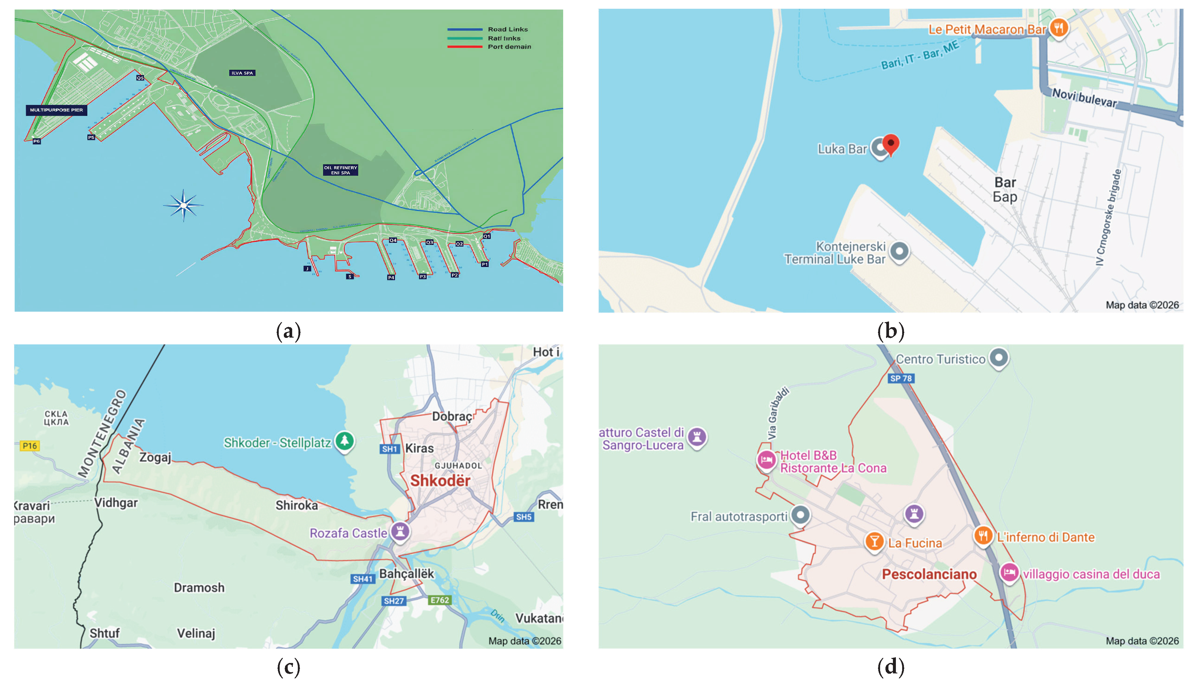
Figure 1 presents the maps of the four selected case studies in the Adriatic–Ionian region, supporting the comparative framework of the study and providing a geographic overview of the selected contexts.
2.3. Hazard Identification and Characterisation
Hazard identification focused on climate-related and environmental processes relevant to the selected study areas. The analysis considered riverine and pluvial flooding, landslides triggered by intense precipitation, wildfires associated with prolonged dry periods and high temperatures, and extreme weather events such as storms and heatwaves. These hazards were selected based on their recurrence, potential impacts on communities and infrastructure, and relevance to the Adriatic–Ionian region.
Hazard characterisation relied on the review of national and European risk assessments, climate and environmental reports, and scientific literature addressing hazard dynamics under changing climatic conditions [
1,
6,
7,
17,
18,
19,
20,
21,
22,
23,
24,
25,
26,
27,
28,
29]. The analysis emphasised the spatial distribution of hazards, their temporal characteristics (e.g., slow-onset versus rapid-onset events), and their potential to interact with exposed assets and infrastructure. Particular attention was given to compound and cascading hazard scenarios, such as flooding or wildfires.
2.4. Exposure and Vulnerability Assessment
Exposure assessment focused on identifying populations, critical infrastructure, economic activities, and environmental assets located in hazard-prone areas. In municipal contexts, exposure includes residential areas, transport networks, public facilities, and essential services. In port environments, exposure extends to port infrastructure, industrial facilities, storage areas for hazardous materials, and intermodal transport connections.
Vulnerability was analysed through a qualitative assessment of physical, institutional, and organisational factors influencing susceptibility to damage and disruption. Physical vulnerability includes aspects such as building characteristics, infrastructure condition, and accessibility constraints. Institutional vulnerability relates to governance structures, coordination mechanisms, and the distribution of responsibilities among authorities and stakeholders. Organisational vulnerability encompasses preparedness levels, emergency planning, and the availability of operational resources.
This qualitative approach reflects findings from disaster risk literature highlighting that vulnerability is often shaped by social and institutional factors that cannot be fully captured through quantitative indicators alone [
5,
6]. The assessment therefore prioritised the identification of systemic weaknesses that may amplify disaster impacts or hinder preventive action.
To improve analytical consistency across the four cases, hazard, exposure, vulnerability, and monitoring conditions were reviewed using a common qualitative assessment matrix. Rather than applying quantitative risk indicators, the analysis relied on structured qualitative coding based on documentary evidence. For each case, hazard relevance, exposure concentration, vulnerability conditions, and monitoring limitations were assessed using recurring analytical dimensions, including territorial significance, critical infrastructure exposure, accessibility constraints, governance complexity, and information availability. The coding logic distinguished between limited, moderate, and high relevance/constraint depending on the consistency and strength of the evidence identified in the reviewed materials.
Table 1 presents the qualitative assessment framework used to support the cross-case analysis. It summarises the main analytical dimensions and the corresponding assessment logic applied across the four case studies to examine hazard relevance, exposure conditions, vulnerability factors, and monitoring limitations in a consistent and comparable way.
2.5. Review of Institutional and Governance Frameworks
To contextualise disaster risk within each study area, the methodology included a structured review of institutional and governance documents relevant to disaster risk reduction, civil protection, environmental monitoring, and port or municipal safety management. Document identification was carried out through official government portals, institutional repositories, public civil protection documentation, port authority websites, and European-level policy and monitoring platforms. In addition, selected scientific literature was used to support the interpretation of governance and monitoring issues where appropriate.
Document selection followed four inclusion criteria: (i) direct relevance to disaster risk management, prevention, preparedness, monitoring, or emergency coordination; (ii) territorial relevance to one of the four selected case studies; (iii) public accessibility and sufficient documentary detail; and (iv) institutional or scientific credibility. Duplicate sources, outdated documents, materials without clear relevance to the selected territories, and sources lacking sufficient analytical value were excluded after screening.
The retained materials were reviewed using a common analytical framework to ensure comparability across the four cases. The analysis focused on four main categories: (i) hazard-related governance context, (ii) exposure and vulnerability conditions relevant to territorial and infrastructural risk, (iii) institutional responsibilities and coordination arrangements, and (iv) monitoring-related provisions, gaps, and information needs. This approach made it possible to examine not only the formal distribution of disaster risk management responsibilities across governance levels and sectors, but also the extent to which prevention, preparedness, and monitoring are addressed within existing frameworks.
Cross-case evidence was synthesised through comparative reading of the four case studies in order to identify recurring patterns, context-specific differences, and common governance and monitoring challenges across municipal and port environments. Particular attention was paid to coordination mechanisms between municipal authorities, civil protection agencies, and port administrations, as governance fragmentation has been identified as a recurring challenge in local disaster risk management [
17,
18,
19,
20,
21,
22,
23,
24,
25,
26,
27].
2.6. Identification of Monitoring Gaps
Building on the hazard, exposure, vulnerability, and governance analysis, the methodology focused on identifying monitoring and information gaps relevant to disaster prevention and preparedness. Monitoring gaps were defined as limitations in the availability, timeliness, spatial resolution, or accessibility of information required to anticipate hazardous conditions and support preventive decision-making.
Monitoring gaps were assessed through four recurring dimensions: (i) timeliness of information, referring to whether data were available rapidly enough to support preventive action during evolving events; (ii) spatial resolution, referring to the level of territorial detail available for local decision-making; (iii) accessibility of observation, referring to the ability to monitor areas that are physically difficult, unsafe, or environmentally constrained; and (iv) operational usability, referring to the extent to which available information could support practical coordination and intervention.
The qualitative coding distinguished between limited, moderate, and high monitoring constraints depending on the consistency and strength of evidence identified in institutional and documentary sources. Monitoring constraints were classified as limited when existing arrangements were broadly adequate and only minor gaps were identified; moderate when relevant information was available but constrained in timeliness, territorial detail, or operational applicability; and high when the reviewed sources indicated clear difficulties in obtaining timely, spatially detailed, or operationally usable information during rapidly evolving risk situations.
Institutional sources were interpreted comparatively by examining how monitoring functions were described across the four case studies in relation to hazard type, territorial accessibility, governance arrangements, and decision-making needs. Particular attention was paid to whether the reviewed documents referred primarily to static assessments, macro-scale monitoring systems, or operationally actionable information at the local or facility level.
The analysis considered both routine monitoring practices and monitoring needs during rapidly evolving risk scenarios. In municipal contexts, gaps often relate to limited coverage of ground-based monitoring systems, difficulties in accessing hazard-prone areas, and reliance on static data products. In port environments, monitoring is frequently oriented towards operational safety and regulatory compliance, with limited integration of environmental and hazard-related observations [
30].
2.7. Assessment of UAV-Based Monitoring Potential
The final methodological step involved assessing the potential contribution of UAV-based monitoring in addressing identified monitoring gaps. This assessment was conducted at a conceptual level and did not involve operational testing or technical system design. UAVs were evaluated in terms of their functional capabilities, including rapid deployment, high spatial resolution, flexible flight planning, and the ability to access areas that may be unsafe or inaccessible during hazardous conditions.
The conceptual assessment of UAV-based monitoring was structured through a comparative qualitative framework rather than through technical performance testing. The evaluation considered five main dimensions: (i) the type and limitations of baseline monitoring tools already in place; (ii) the operational scenario in which additional observation would be needed, such as flood mapping, slope inspection, fire-related situational awareness, or rapid infrastructure assessment; (iii) the technical suitability of UAV deployment in terms of spatial resolution, accessibility, sensing flexibility, and rapid deployability; (iv) key operational constraints, including regulatory restrictions, weather sensitivity, safety requirements, and data-processing needs; and (v) the expected contribution to prevention-oriented decision-making, particularly with regard to timeliness, territorial detail, and support for local coordination.
From an operational perspective, different UAV configurations may be more suitable for different disaster scenarios. Multi-rotor UAVs are generally more appropriate for local inspection, facility-level observation, and operations requiring hovering or deployment in spatially constrained environments, such as port areas or inaccessible road sections. Fixed-wing UAVs may be more suitable for covering larger territorial extents [
31], for example in flood mapping or wildfire-affected landscapes, where wider-area observation is required. In both cases, the practical value of UAV deployment depends not only on image acquisition but also on the ability to integrate UAV-derived imagery, orthophotos, thermal data, or terrain models into existing monitoring and decision-support workflows. For this reason, data processing and interoperability with institutional information systems represent important considerations in the assessment of UAV-based monitoring potential. Where relevant, UAV-derived data may also be combined with existing geospatial, meteorological, or early warning information to support more detailed and timely local situational awareness.
Cost considerations were addressed qualitatively in terms of operational resource requirements, including the need for trained operators, flight permissions, data-processing capacity, and coordination with existing emergency management procedures, rather than through quantitative cost estimation.
The assessment focused on how UAV-based monitoring could complement existing monitoring systems and support disaster risk prevention and preparedness, rather than replacing established practices. This perspective aligns with research emphasising the importance of integrating emerging technologies within existing governance and operational frameworks to maximise their practical relevance and sustainability [
14,
15].
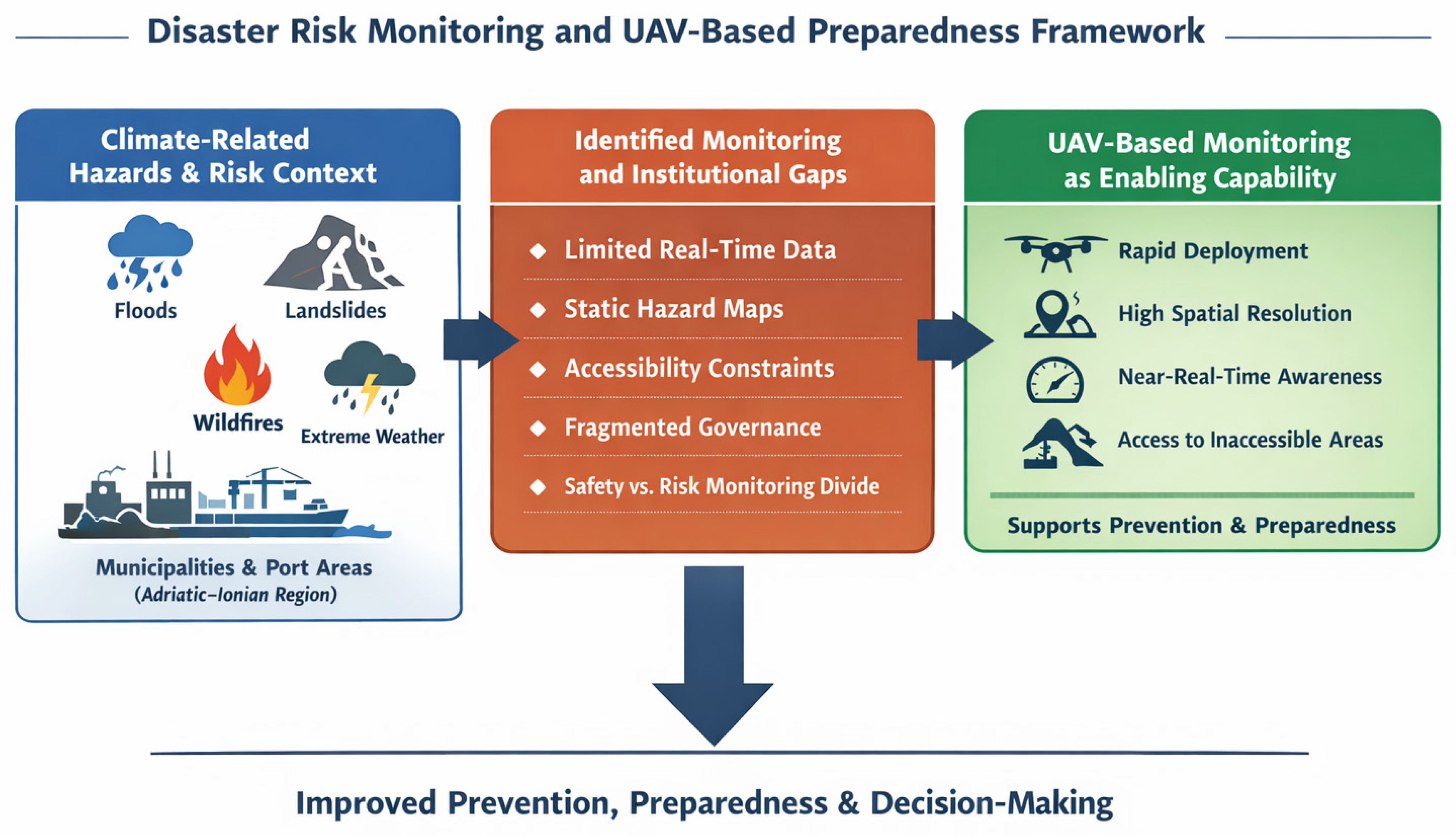
The overall conceptual framework adopted in this study, linking disaster risk context, identified monitoring and governance gaps, and the potential role of UAV-based monitoring in prevention and preparedness, is illustrated in
Figure 2.
The framework illustrates how disaster risk in municipalities and port areas emerges from the interaction between multiple climate-related hazards and institutional and monitoring limitations, and how UAV-based monitoring can act as an enabling capability to enhance situational awareness, support early detection of hazardous conditions, and improve prevention-oriented decision-making. The approach emphasises integration with existing disaster risk management systems rather than replacement of established practices.
This qualitative framework was used to compare the relevance and feasibility of UAV-based monitoring across the four selected case studies.
3. Results
3.1. Territorial Hazard Profiles and Historical Evidence
The comparative analysis of the selected municipalities and port areas reveals territorially differentiated but structurally significant hazard patterns, supported by institutional documentation and historical evidence.
In the Municipality of Shkodra, flood risk represents a recurrent and structurally embedded hazard. According to the Flood Risk Management Plan for the Shkodra Region [
22], large-scale flood events in 2010 resulted in extensive inundation of residential areas and agricultural land, requiring temporary evacuations and emergency interventions. The interaction between the Drin and Buna river systems, combined with rainfall variability and transboundary hydrological dynamics, creates a compound flood regime. These recurrent events confirm that flood risk in Shkodra is systemic rather than episodic.
In Pescolanciano, hydrogeological instability constitutes the dominant hazard profile. National assessments of hydrogeological risk in Italy classify parts of the Molise region within elevated landslide susceptibility categories [
23]. These include areas corresponding to medium and high hazard levels, reflecting persistent geomorphological instability. While individual events are often localised, their cumulative effects compromise road accessibility and increase infrastructure maintenance burdens. Furthermore, the presence of the Collemeluccio–Montedimezzo Alto Molise Biosphere Reserve introduces environmental sensitivity constraints that influence disaster prevention measures [
24].
The Port of Bar demonstrates a hazard profile dominated by fire-related and technological risks. Municipal fire protection records and national fire protection plans highlight repeated fire interventions in port-related facilities, including warehouses and electrical installations [
29]. European Forest Fire Information System (EFFIS) statistics confirm sustained wildfire pressure in Montenegro in recent years [
25], reinforcing the structural nature of fire risk in coastal and peri-urban environments.
In the Port of Taranto, disaster risk is largely driven by industrial and technological hazards. Climate change adaptation challenges for seaports are documented in the literature [
4]. For Taranto, spatial data from the Regione Puglia WebGIS indicate the presence of industrial facilities classified as Major Accident Hazard (MAH) installations, meaning sites subject to strict safety regulations due to the potential for large-scale industrial accidents, located close to critical port infrastructure [
20]. The co-location of industrial facilities, transport nodes, and urban proximity increases the potential for cascading effects under extreme conditions [
4,
8,
9,
30].
Across all study areas, historical and institutional evidence confirms that disaster risk is multi-layered and territorially embedded.
An overview of the selected study areas and their dominant disaster risks is provided in
Table 2.
3.2. Exposure and Vulnerability Patterns
Exposure patterns in the analysed territories reveal a strong concentration of population, infrastructure, and economic assets within hazard-prone zones.
In Shkodra, residential areas and agricultural land are located within floodplains subject to recurrent inundation [
22]. Repeated damage to transport infrastructure and drainage systems indicates persistent structural exposure. Similar patterns of vulnerability associated with spatial configuration and governance fragmentation have been identified in disaster risk research [
6,
7].
In Pescolanciano, dispersed settlements and mountainous terrain amplify accessibility challenges during hydrogeological events [
23]. The interaction between environmental protection requirements within UNESCO-recognised areas and disaster risk reduction interventions introduces additional complexity [
24].
Port environments exhibit concentrated exposure of high-value and interdependent infrastructure. In Taranto, industrial installations and maritime logistics facilities coexist within confined operational areas, increasing systemic risk and the potential for cascading disruption [
4,
8,
9]. In Bar, the proximity of hazardous material storage facilities to transport corridors and forested areas increases combined technological and wildfire risk [
25,
29].
Institutional vulnerability emerges as a cross-cutting factor. Disaster risk responsibilities are distributed among multiple governance levels and sectoral authorities, a fragmentation that has been widely documented in disaster risk management literature [
6,
7,
17,
18,
19,
20,
21,
22,
23,
24,
25,
26,
27,
28,
29]. While regulatory frameworks are formally established, the operational integration of hazard monitoring and prevention remains uneven.
These structural exposure and vulnerability patterns demonstrate that disaster risk is conditioned not only by hazard intensity but also by territorial configuration and governance arrangements.
3.3. Monitoring and Information Gaps
A cross-case comparison reveals that monitoring and information limitations constitute a structural component of disaster risk across all analysed territories.
In the Municipality of Shkodra, flood risk management relies primarily on hydrological forecasting systems and institutional reporting mechanisms defined at national level [
22]. While these systems provide essential early warning functions, limitations persist at the local operational scale. Specifically, real-time spatial mapping of flood extent, dynamic assessment of exposed assets, and rapid situational updates during fast-onset inundation events remain constrained. Such limitations reduce the ability of local authorities to prioritise interventions, manage evacuations efficiently, and allocate emergency resources in a targeted manner. Similar challenges related to the spatial and temporal resolution of disaster monitoring systems have been identified in vulnerability research [
6,
7]. This means that, during flood events, local authorities may receive warning information but still lack sufficiently detailed and up-to-date visual information on the exact extent of inundation and the most affected areas.
In Pescolanciano, hydrogeological risk monitoring is primarily based on regional assessments and static hazard classifications [
23]. Although these classifications provide essential long-term risk mapping, they do not necessarily capture short-term slope instability or post-event terrain changes. The dispersed and mountainous nature of the territory further constrains continuous ground-based observation. In environmentally protected zones associated with the UNESCO Biosphere Reserve [
24], permanent infrastructure-based monitoring solutions may be limited by environmental protection requirements, increasing reliance on flexible and low-impact observation approaches. The risk of forest fires further intensifies the vulnerability of territories already affected by hydrogeological instability and should therefore be systematically integrated into territorial risk analyses. This may limit the timely detection of terrain instability and make it more difficult to assess slope conditions and access constraints in mountainous areas.
In the Port of Bar, fire detection and emergency response are supported by dedicated port-level fire protection units and national plans [
26,
27,
29]. However, wildfire interface risk and complex industrial settings require rapid visual situational awareness during evolving incidents. European-level wildfire monitoring systems such as EFFIS [
25] provide macro-scale information, but operational decision-making within port facilities requires higher spatial resolution and immediate visibility of infrastructure conditions. As a result, emergency actors may have limited facility-level visual information during evolving fire-related situations, especially where broad-area monitoring does not capture local operational detail.
In the Port of Taranto, industrial and technological risks are addressed through formalised safety management and regulatory compliance frameworks [
30]. Nevertheless, the coexistence of Major Accident Hazard (MAH) installations and climate-related stressors creates scenarios where environmental monitoring, infrastructure condition assessment, and rapid visual inspection become critical during extreme events. Literature on port climate adaptation emphasises the need for improved data integration and situational awareness in complex port systems [
4]. This may reduce the availability of rapid visual information needed to assess infrastructure conditions and support local decision-making during extreme events or industrial emergency situations.
Across all reference areas, a recurring pattern emerges: monitoring systems are either macro-scale (national or European platforms) or static (hazard maps and periodic assessments). During rapidly evolving events, such as floods, wildfire spread, landslide activation, or industrial incidents, local authorities and port operators face constraints in obtaining high-resolution, near-real-time spatial information. These monitoring gaps do not reflect the absence of institutional structures, but rather the limited integration of dynamic observation tools within local decision-making processes.
The identification of these structural monitoring gaps provides the analytical basis for assessing complementary observation technologies capable of enhancing situational awareness during prevention and preparedness phases.
3.4. Implications for Disaster Risk Prevention
The identified hazard profiles, exposure patterns, vulnerability drivers, and monitoring gaps point to a clear need for enhanced disaster risk prevention measures at the municipal and port level. Prevention efforts are constrained not only by the intensity of hazards but also by limitations in situational awareness and information availability during critical periods.
Effective disaster prevention requires timely detection of hazardous conditions, continuous observation of exposed assets, and the ability to rapidly assess evolving risk scenarios. The results indicate that existing monitoring systems alone are insufficient to meet these requirements, particularly in contexts characterised by limited accessibility, complex infrastructure, and fast-onset hazards.
Across the four cases, a common comparative pattern emerges: while the dominant hazards differ, prevention needs are consistently shaped by the interaction between territorially specific exposure, governance-related vulnerability, and limitations in timely and spatially detailed monitoring.
3.5. Potential Role of UAV-Based Monitoring
The monitoring gaps identified across the analysed territories indicate the need for complementary observation tools capable of providing high-resolution, flexible, and rapidly deployable situational awareness.
Unmanned Aerial Vehicles (UAVs) have been widely recognised in the literature as effective platforms for environmental monitoring, photogrammetry, and disaster-related observation [
13]. Their operational flexibility, high spatial resolution, and capacity for rapid deployment make them particularly suitable for contexts where ground-based monitoring is constrained or unsafe [
14,
15].
In flood-prone areas such as Shkodra, UAV-based aerial mapping could complement hydrological early warning systems [
22] by providing real-time visualisation of inundation extent, identification of isolated settlements, and assessment of infrastructure exposure during fast-onset events. Unlike static flood hazard maps, UAV-generated orthophotos and georeferenced imagery allow dynamic updating of spatial conditions, supporting more targeted evacuation and resource allocation decisions.
Across the four cases, the expected contribution of UAV-based monitoring differs according to hazard type, territorial accessibility, and the scale at which existing monitoring systems operate.
In hydrogeologically unstable territories such as Pescolanciano, UAV-based photogrammetry and terrain modelling can support the identification of slope instability, post-event landslide mapping, and inspection of inaccessible road sections. This capability is particularly relevant in mountainous and environmentally sensitive areas [
23,
24], where permanent ground-based monitoring infrastructure may be limited or intrusive.
In the Port of Bar, where fire-related incidents represent a structural risk pattern [
25,
27], UAVs equipped with visual and thermal sensors could enhance early detection of fire outbreaks and support rapid assessment of fire spread within industrial and storage areas. While macro-scale monitoring systems such as EFFIS provide regional wildfire indicators [
25], UAVs can deliver facility-level situational awareness essential for operational decision-making.
In the Port of Taranto, characterised by Major Accident Hazard (MAH) installations and complex industrial interdependencies [
4,
8,
9,
30], UAV-based monitoring could complement existing safety management systems by enabling rapid visual inspection of critical infrastructure following extreme weather events or industrial incidents. The literature on port climate adaptation emphasises the importance of integrating new monitoring technologies within established governance and safety frameworks [
4].
Importantly, UAV-based monitoring should not be interpreted as a replacement for existing disaster risk management systems. Instead, its added value lies in enhancing the temporal and spatial resolution of situational awareness during prevention and preparedness phases. The effectiveness of UAV deployment depends on its integration into institutional procedures, data-sharing mechanisms, and clearly defined operational protocols.
By directly addressing the monitoring limitations identified in
Section 3.3, UAV-based approaches represent a complementary and scalable capability for strengthening disaster risk prevention and preparedness in both municipal and port environments.
In addition to real-time visual observation, UAV-based monitoring can support advanced data analysis through automated processing of aerial images. Image comparison, basic change detection, and AI-supported interpretation can help identify flooded areas, wildfire spread, terrain changes, or infrastructure damage more quickly. This enhances situational awareness and supports more informed and timely preventive decision-making.
Table 3 summarises the main cross-case findings by linking the dominant hazard profile and structural vulnerability factors of each study area with the identified monitoring gaps and the potential contribution of UAV-based monitoring. It synthesises the analytical results presented in the previous subsections and clarifies how UAV-based monitoring may help address context-specific monitoring needs.
As shown in
Table 3, the added value of UAV-based monitoring lies not in replacing existing systems, but in enhancing the spatial and temporal resolution of information available to support prevention-oriented decision-making.
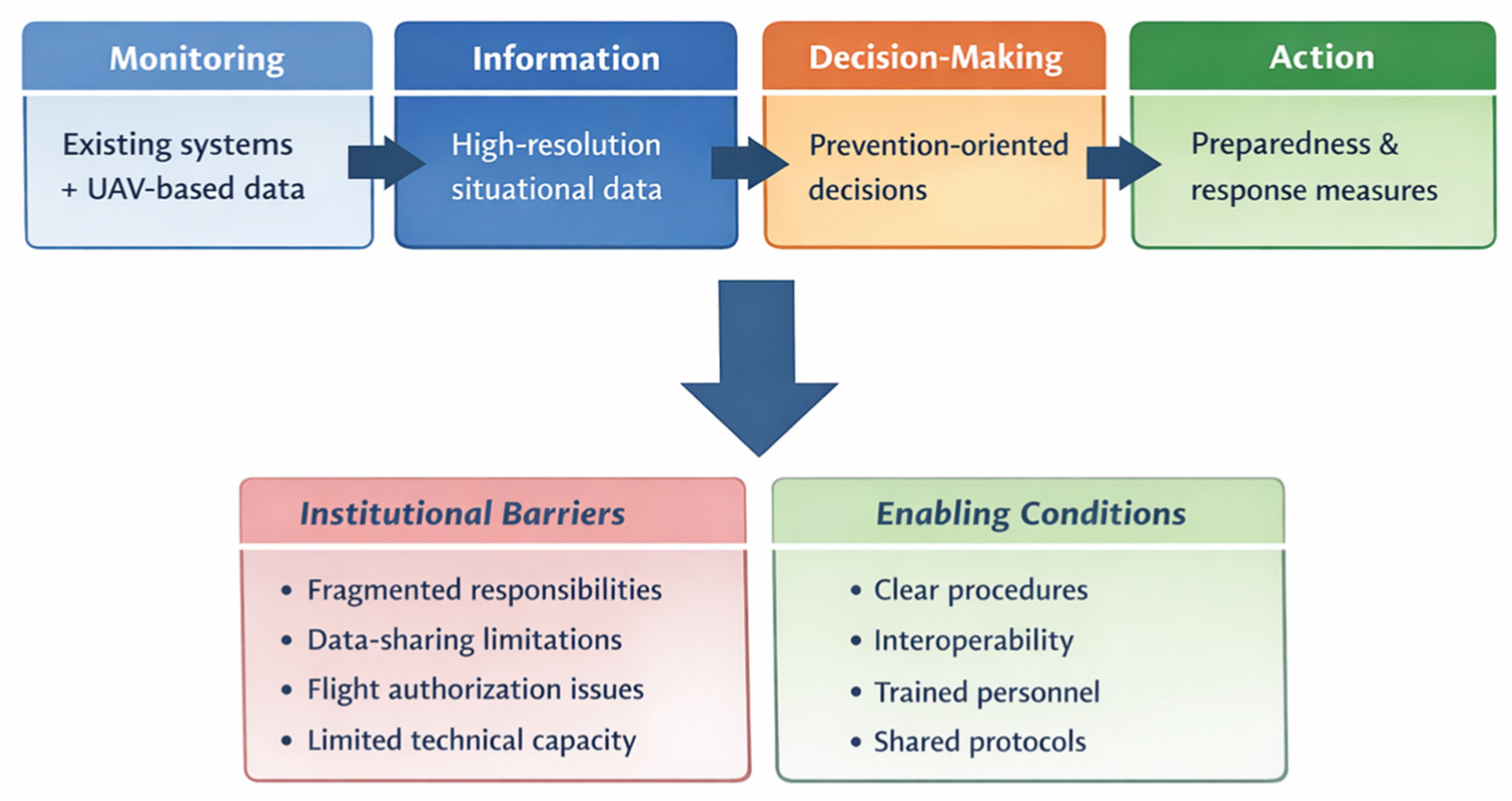
Figure 3 illustrates how UAV-based monitoring may strengthen the chain from monitoring to information, prevention-oriented decision-making, and action when integrated into existing disaster risk management systems.
3.6. Summary of Results
The potential value of UAV-based monitoring lies not only in image acquisition, but in its ability to improve the full prevention-oriented chain from monitoring to action. In this sense, UAVs may complement existing monitoring systems by generating higher-resolution and more timely information products, such as flood extent updates, localised infrastructure inspection, slope condition assessment, or facility-level visual situational awareness. When integrated into existing institutional procedures, these information products can support more targeted decision-making, including prioritisation of inspections, access restrictions, allocation of emergency resources, and activation of preventive or preparedness measures. However, the effectiveness of this chain depends on clear institutional roles, data-sharing mechanisms, operational protocols, and sufficient technical and human capacity.
Overall, the results demonstrate that disaster risk in the analysed municipalities and port areas is shaped by the interaction of climate-related hazards, exposure of population and infrastructure, institutional vulnerability, and monitoring capacity gaps. A clearer contrast can be observed between the two municipal cases, where risk is primarily associated with environmentally driven hazards and territorial accessibility constraints, and the two port cases, where natural and technological risks intersect with infrastructure interdependencies and higher potential for cascading effects. Floods, landslides, wildfires, and compound hazard scenarios pose increasing challenges to disaster prevention and preparedness. The analysis highlights the importance of enhancing situational awareness and monitoring capabilities as a foundation for effective preventive action and identifies UAV-based monitoring as a relevant and complementary approach to address identified gaps.
4. Discussion
A cross-case comparison reveals both shared structural vulnerabilities and context-specific risk configurations. Shkodra and Pescolanciano are primarily characterised by environmentally driven hazards, where exposure is closely linked to geomorphological conditions and land use patterns. In contrast, the Ports of Bar and Taranto present hybrid risk profiles in which natural hazards intersect with industrial and logistical interdependencies. This distinction highlights that while monitoring gaps are present across all cases, the scale and criticality of cascading effects are significantly higher in port environments, where disruptions may propagate through national and international supply chains.
The results of this study confirm that disaster risk in municipalities and port areas is shaped by the interaction of climate-related hazards, exposure patterns, vulnerability drivers, and institutional capacities [
5,
6,
7]. Floods, landslides, and wildfires emerge as dominant hazards across the analysed territories, but their impacts are not determined by hazard intensity alone. Instead, risk is amplified by governance fragmentation, limited monitoring capacity, and constraints in situational awareness, particularly during rapidly evolving events [
6,
7,
10,
12].
The findings also suggest that disaster risk in port and municipal environments is not solely a function of hazard intensity, but of systemic interdependencies between infrastructure, governance structures, and information flows [
8,
9,
10,
11,
12]. In complex port systems, cascading effects may emerge not only from physical damage but from temporary disruptions in logistics chains and energy supply [
8,
9]. This reinforces the need for integrated risk assessment approaches that combine structural analysis with dynamic monitoring capabilities. UAV-based monitoring, in this context, contributes primarily to improving situational awareness rather than eliminating underlying vulnerabilities.
At the municipal level, the findings highlight the critical role of local authorities in disaster risk prevention and preparedness. Municipalities are responsible for land-use planning, local infrastructure, and first-instance emergency coordination (when no additional agencies are involved or needed), yet they often operate with limited technical resources and fragmented institutional arrangements. These constraints reduce the effectiveness of preventive action, especially when hazards develop rapidly and require timely, spatially detailed information to support decision-making. The results are consistent with disaster risk research emphasising that vulnerability is strongly influenced by institutional and organisational factors rather than physical exposure alone [
6].
Port areas present additional layers of complexity. Ports are not only transport nodes but also socio-technical systems where industrial activities, hazardous materials, logistics operations, and surrounding urban areas interact [
4,
8,
11]. The analysis shows that climate-related hazards affecting ports can trigger cascading effects that extend beyond port boundaries, disrupting transport networks and regional economic activities [
4,
8,
9]. The separation between operational safety monitoring and environmental or hazard-related monitoring further limits the ability of port authorities to anticipate and manage disaster-related risks.
International policy analyses emphasise that climate-resilient infrastructure requires improved monitoring, adaptive governance, and integration of risk information into long-term investment planning [
32].
A key contribution of this study lies in identifying monitoring gaps as a structural component of disaster risk. Existing monitoring systems, often based on fixed sensors or periodic assessments, are insufficient to capture the dynamic nature of hazards such as floods, landslides, and wildfires. Limited accessibility and safety constraints during emergencies further restrict the use of ground-based monitoring approaches. These gaps reduce situational awareness precisely when preventive and preparedness measures are most needed.
Within this context, UAV-based monitoring is discussed as a complementary and enabling capability rather than a standalone technological solution. By providing flexible, rapid, and high-resolution observation, UAVs can support early detection of hazardous conditions, improve situational awareness, and enhance information flows between local authorities, civil protection agencies, and port operators. Importantly, the effectiveness of UAV-based monitoring depends on its integration within existing governance and operational frameworks. Without clear roles, procedures, and data-sharing mechanisms, technological capabilities alone are unlikely to translate into improved disaster risk prevention.
The findings also highlight the importance of adopting a needs-driven approach to the integration of emerging technologies in disaster risk management. Rather than focusing on technological performance in isolation, the proposed framework links UAV capabilities to specific monitoring requirements identified through disaster risk analysis. This approach enhances the practical relevance of UAV-based monitoring and supports its adaptation to diverse municipal and port contexts.
5. Study Limitations and Future Research
This study has several limitations that should be acknowledged. First, the analysis is qualitative and exploratory in nature and therefore does not provide quantitative risk scoring, probabilistic loss estimation, or performance-based comparison across cases. Second, the study relies primarily on document analysis and cross-case synthesis, which may reflect differences in data availability, institutional reporting practices, and source detail across the selected territories. Third, the number of case studies is limited to four reference areas, which supports in-depth comparison but also constrains the generalisability of the findings beyond similar municipal and port contexts.
In addition, the assessment of UAV-based monitoring remains conceptual and does not include empirical deployment, operational testing, or validation of specific workflows under real disaster conditions. For this reason, the study should be interpreted as a structured analytical framework rather than as a demonstration of operational effectiveness.
Future research could build on this framework through pilot UAV deployments in municipal and port settings, comparative testing of different sensing and data-processing configurations, and evaluation of how UAV-derived information can be integrated into institutional decision-making procedures. Further work could also examine cross-border coordination, data-sharing arrangements, and AI-supported image interpretation for faster disaster-related situational awareness.
6. Operational and Regulatory Constraints for UAV Deployment
While UAV-based monitoring offers clear advantages in terms of spatial resolution and rapid deployment, several operational and regulatory constraints must be acknowledged. UAV deployment in port environments is subject to airspace restrictions, safety regulations, and coordination with maritime and civil aviation authorities. In industrial settings such as the Port of Taranto, additional safety protocols may limit flight operations near hazardous installations. In environmentally sensitive areas and military zones, additional regulatory and authorisation requirements may further increase the complexity of obtaining overflight permissions.
Although the three case countries broadly follow similar risk-based approaches to UAV operations, the practical implementation of these rules remains country-specific [
33,
34,
35]. While the general regulatory logic is increasingly harmonised, differences still arise in relation to national authorisation procedures, controlled airspace requirements, UAS geographical zones, and the institutional coordination needed for operational deployment. In Italy, UAV deployment is framed through ENAC procedures, while emergency coordination is embedded in the National Civil Protection Service [
17,
33]. In Montenegro, the Civil Aviation Agency regulates drone operations, while emergency coordination is handled through the Directorate for Emergency Management [
27,
34]. In Albania, drone operations fall under the Civil Aviation Authority, while disaster risk reduction and emergency coordination are managed by the National Civil Protection Agency [
21,
35]. These differences indicate that the feasibility of UAV-based monitoring depends not only on technical suitability, but also on the practical regulatory and organisational context in which operations are carried out, including authorisation pathways, coordination structures, and institutional procedures where relevant. Furthermore, meteorological conditions, including strong winds and precipitation, may reduce operational windows during extreme events. Data processing time, availability of trained operators, and integration of UAV-derived information into existing emergency management workflows also represent critical factors influencing effectiveness.
Therefore, UAV-based monitoring should be understood not as a standalone solution, but as a complementary capability whose impact depends on institutional integration, regulatory compliance, and operational readiness.
7. Conclusions
This study analysed disaster risk in selected municipalities and port areas in the Adriatic–Ionian region, focusing on climate-related hazards, exposure patterns, vulnerability drivers, and monitoring capacity gaps relevant to disaster prevention and preparedness. The analysis demonstrates that floods, landslides, wildfires, and compound hazard scenarios pose increasing challenges to local authorities and port operators, particularly in contexts characterised by high exposure and limited situational awareness.
A central conclusion is that disaster risk is strongly influenced by limitations in monitoring and information availability at the local and port level. These limitations constrain preventive action, reduce preparedness, and increase the likelihood of cascading impacts during extreme events. Addressing monitoring gaps is therefore a critical component of strengthening disaster risk prevention and preparedness.
Building on these findings, this paper proposed UAV-based monitoring as a complementary capability to support disaster risk prevention and preparedness in municipalities and port areas. Rather than reporting operational deployment, this study adopted a conceptual and needs-driven approach, linking identified risk and monitoring gaps with UAV capabilities relevant to early detection, situational awareness, and decision-making. The proposed framework provides a structured basis for integrating UAV-based monitoring within existing disaster risk management systems, emphasising governance alignment and operational feasibility.
At the European level, coordination mechanisms such as the EU Civil Protection Mechanism play a key role in supporting prevention, preparedness, and response capacities, particularly in cross-border and multi-hazard contexts [
36].
This comparative analysis demonstrates that strengthening disaster prevention in port and municipal environments requires not only technological innovation but also institutional coordination and governance integration. UAV-based monitoring can enhance the spatial and temporal resolution of risk information, yet its effectiveness depends on its incorporation into formal safety and emergency management frameworks.
By linking territorially grounded hazard analysis with operational monitoring capabilities, this study contributes to bridging the gap between risk assessment and real-time situational awareness in complex socio-technical systems. The approach outlined here may support scalable prevention strategies across the Adriatic–Ionian region and other multi-hazard coastal environments.
Based on these findings, four practical priorities can be identified for policymakers and technology developers. First, UAV-based monitoring should be embedded within formal disaster risk management procedures rather than treated as a standalone technological option. Second, institutional interoperability and data integration should be strengthened so that UAV-derived information can support early warning, inspection, and prevention-oriented decision-making. Third, pilot deployments should be used to test standardised data-processing workflows, including AI-supported image analysis where appropriate. Fourth, cross-regional cooperation mechanisms should be promoted to facilitate shared protocols, operational learning, and wider transferability across Adriatic–Ionian municipal and port environments.




 ,
,