The application of BIM methods and tools plays a key role in transportation infrastructure asset management. Road pavements represent one of the main components of the asset, which greatly influences safety and quality of service for users. The work presented herein exploited the potentialities of BIM processes and methods for management of road pavement structures. The specific goal was to define best practice for development of a methodological framework for Pavement Information Modelling (PIM). The starting point of the process was the identification of the specific BIM use, as intended by Kreider and Messner [1]. In this case, the BIM use identified concerned the 3rd (3D), 4th (4D), and 5th (5D) dimensions of BIM. The adopted approach had the aim to define the steps to build PIM based on geometrical and structural parameters to be used as a database for different kinds of maintenance strategies. Within this context, the main objectives of the study can be summarized as follows:
- (1)
- Define the steps to develop a PIM including all the relevant information to be stored for management purposes, from data collection to data restitution,
- (2)
- Define a best practice for the integration among BIM tools and road pavement management methods in order to obtain a digital repository for predictive maintenance strategies,
- (3)
- Define a planning and cost database for the different technologies and materials involved in the different maintenance strategies.
From a practical point of view, the methodological framework was divided into three main categories (Figure 1) dealing with data: (i) data collection and input definition, which includes the analysis of available data and the BIM tools to be used to develop specific workflows; (ii) data processing, by dividing the workflows and related tasks in sub-sections for the fulfilment of the previously enounced objectives; (iii) data output, by defining the final result of each workflow.
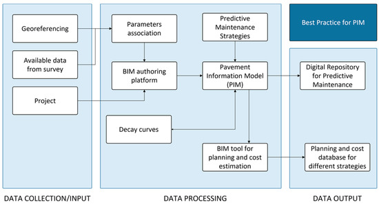
Figure 1.
Pavement Information Modelling framework.
Author Contributions
Conceptualization, O.B., A.V. and A.O.; methodology, O.B., A.V. and A.F.; validation, A.F. and A.O.; formal analysis, A.V. and A.F.; investigation, O.B. and A.V.; resources, A.O.; data curation. A.V. and A.F.; writing—original draft preparation: A.V. and A.F.; writing—review and editing, O.B. and A.O.; visualization, A.V. and A.F.; supervision, O.B. and A.O. All authors have read and agreed to the published version of the manuscript.
Funding
This research received no external funding.
Institutional Review Board Statement
Not applicable.
Informed Consent Statement
Not applicable.
Data Availability Statement
Data sharing not applicable.
Conflicts of Interest
The authors declare no conflict of interest.
Reference
- Kreider, R.G.; Messner, J.I. The Uses of BIM: Classifying and Selecting BIM Uses; Version 0.9; The Pennsylvania State University: State College, PA, USA, 2013; Available online: http://bim.psu.edu (accessed on 1 February 2022).
Publisher’s Note: MDPI stays neutral with regard to jurisdictional claims in published maps and institutional affiliations. |
© 2022 by the authors. Licensee MDPI, Basel, Switzerland. This article is an open access article distributed under the terms and conditions of the Creative Commons Attribution (CC BY) license (https://creativecommons.org/licenses/by/4.0/).