
Article

Göbeklitepe in Palaeoclimate Context: Human Responses to Climate Change in the Upper Tigris and Euphrates Basins from the Younger Dryas to the Early Holocene


by
Lee Clare
Istanbul Department, German Archaeological Institute, İnönü Cad. 10, 34437 İstanbul, Türkiye
Heritage 2026, 9(5), 179; https://doi.org/10.3390/heritage9050179
Submission received: 17 June 2025 / Revised: 15 April 2026 / Accepted: 21 April 2026 / Published: 30 April 2026
(This article belongs to the Special Issue The Archaeology of Climate Change)

Abstract

The upper Euphrates and Tigris basins are located in modern-day Southeast Türkiye, on the northern periphery of the Fertile Crescent. From the eleventh to the eighth millennium calBC, during the Younger Dryas and the Early Holocene, human communities in this region transitioned from mobile hunter-foragers to settled agriculturalists. This process went hand in hand with the construction of the first monumental buildings, such as those at Göbeklitepe and its sister site Karahantepe. Although the Early Holocene is broadly understood as a phase of climate amelioration following the Younger Dryas climate reversal, it also featured short and abrupt phases of climatic instability, so-called rapid climate change (RCC) intervals. This contribution examines demographic trends against the backdrop of climate change to highlight potential impacts on human communities in this key region of Neolithisation, placing Göbeklitepe in its broader cultural and palaeoclimate context.

1. Introduction

Since the first excavations at the prehistoric site of Nevali Çori (1983–1991) in the frame of the Atatürk Dam construction project [1] and subsequent fieldworks initiated at Göbeklitepe in 1995, the Şanlıurfa region of modern-day southeastern Türkiye has become a hub of research on the transition from hunter-gatherer to agricultural economies in the Early Holocene (EH). Located in a core zone of Neolithisation [2], which includes the Upper Euphrates Basin, extending into Northern Syria, and the Upper Tigris Basin around the city of Mardin, expanding into northern parts of modern-day Iraq, this region is situated on the northern fringe of what is commonly referred to as the Fertile Crescent. In 2021, research into the EH of the Şanlıurfa region received a boost from the newly formulated Taş Tepeler project by the Ministry of Culture of the Republic of Türkiye [3]. This project has brought together fieldwork at several Pre-Pottery Neolithic (PPN) sites [4,5,6,7,8,9,10], which include continued excavations at Göbeklitepe and its sister site, Karahantepe [11,12,13,14,15,16,17,18]. Although settlements coinciding with the preceding Younger Dryas (YD) have not yet been definitively encountered among the Taş Tepeler, further south and east, a small number of PPN sites with Epipalaeolithic settlement phases have been excavated along the Euphrates and Tigris rivers [19,20,21,22,23]. Neolithic research along the Tigris has been conducted within the framework of the Ilısu Dam project, which has also included excavations at other PPN settlements [24,25], thereby adding to the insights gained from earlier research in this region [26,27,28,29,30].
One aim of the Taş Tepeler project is to investigate the palaeoenvironmental conditions of the Şanlıurfa region from the Late Pleistocene to the Early Holocene, particularly in relation to the transition from hunter-gatherer to agricultural economies. Within this framework, the present contribution identifies periods of abrupt climate change and instability that may have influenced socio-economic adaptations across the upper Euphrates and Tigris basins. Beginning with the Younger Dryas and continuing through the Early Holocene climatic amelioration, the focus is on intervals of rapid climate change (RCC), considered alongside regional archaeological evidence from the same period. These observations are discussed with reference to vulnerability studies [31,32,33,34,35,36,37], resilience theory [38], and the adaptive cycle model [39], which are employed here in a heuristic sense to explore possible correspondences between broad socio-ecological dynamics and archaeological trajectories, without implying formal phase assignment or model testing [40]. Regional palaeoclimate records are treated as general environmental background, while available radiocarbon dates and settlement patterns provide a framework for situating long-term socio-ecological change.

2. Göbeklitepe

Göbeklitepe is a Pre-Pottery Neolithic (PPN) site located in the Germuş Mountains, east of the modern city of Şanlıurfa, on a limestone plateau overlooking the Harran plain to its south (~775 m a.s.l.) (Figure 1). Initially identified as a prehistoric site in 1963, excavations at Göbeklitepe were initiated in 1995, when it was already being referred to as a cultic site of major significance [41]. The last three decades have seen continuous research at the 9-hectare large mound, culminating in its inscription as a UNESCO World Heritage Site in 2018 [42]. Notably, over the last several years, re-evaluations and new excavations have revealed that Göbeklitepe was also a significant domestic settlement [14,43]. Although not detracting from its importance, this realisation has served to relativise earlier claims that Göbeklitepe was the smoking gun of Neolithisation, where early sedentism, the domestication of plants and animals, and the emergence of more complex socioeconomic systems were triggered by the demands of more organised forms of religion [12]; indeed, this narrative proves especially difficult to uphold considering there is still no evidence for domesticated animals at Göbeklitepe [44], and there are only extremely sporadic remains of morphologically domesticated cereals from stratigraphically late (PPNB) deposits (pers. comm. F. Antolin).
The restructuring of an earlier formulated stratigraphic sequence at Göbeklitepe became necessary following the realisation that the special (monumental) buildings (former Layer III, assigned to the Pre-Pottery Neolithic A/PPNA/~9600–8700 calBC) were long-lived structures, their later phases contemporaneous with the smaller rectangular-trapezoid (domestic) buildings (former Layer II, assigned to the Early Pre-Pottery Neolithic B/EPPNB/~8700–8200 calBC) [14]. This has demonstrated that by the EPPNB, Göbeklitepe had evolved into a substantial domestic settlement, with the special buildings as a spatial focal point. The gradual abandonment of the site from the late 9th millennium calBC, which saw the disappearance of its characteristic monumental architecture with its T-shaped limestone monoliths, heralded the onset of early farming in the region and the foundation of new settlements in the Harran Plain, e.g., Gürcütepe [18,41]. A key focus of recent research at Göbeklitepe is the diachronic study of settlement structure, aimed at improving our understanding of the vulnerability of this early Neolithic community to ecological and social change and its resilience through adaptive forms of community organisation.

3. Methodology: Absolute Chronologies, Palaeoclimate Data, Adaptive Cycles and Vulnerability

A first step will see the generation of a radiocarbon-based demographic proxy that is directly comparable to palaeoclimate records. This will include the systematic assessment of radiocarbon data from a total of 22 Epipalaeolithic and PPN sites. Following established procedures, summed probability distributions (SPD) will be used as a demographic indicator [45,46,47,48]. The resulting radiocarbon chronology is then compared with selected palaeoclimate proxy records to assess potential temporal correspondences.
Using SPD curves as a proxy for population trends is not a new method, and its limitations have been recognised [48]. Among the main criticisms of this approach are sampling errors and the effects of calibration on the data. However, it is also acknowledged that data in this form can still be useful, especially when analysing long-term trends over millennia. For this reason, SPD will be considered, even though the data should not be regarded as definitive proof of the implied demographic trends. In an effort to address some criticisms of this methodology, the radiocarbon data analysed will be filtered, with problematic ages, such as outliers that do not reflect the archaeological material culture and those with high standard deviations (>100 14C years), excluded.
Over the years, doubts have also been raised regarding whether the socio-cultural changes and the coincident periods of YD and EH climate change were causally related or, at best, whether this issue has been oversimplified [49,50]. Nonetheless, there is a tangible consensus that adaptation to changing climates certainly played a role in some cases, especially considering that humans are inherently intertwined with their environments, as originally expressed in the concepts of cultural ecology after J.H. Steward [51]. In fact, dedicated research continues to uncover new correlations between climate proxy data, changing settlement patterns, (material) culture change, and the adjustment of subsistence strategies in the Late Pleistocene and during the Holocene in the Northern Hemisphere [52,53,54,55,56,57]. Certainly, temporal correlation does not imply causation, but this does not mean that correlations between climate upheaval and shifts in material culture should be wholly ignored; indeed, environmental change is one factor among many that can influence socio-cultural processes.
Instead, discussions need to approach how we can best combine palaeoclimate and archaeological data and use them to shed light on the prehistoric past. The approach taken in this contribution is to harness the concept of adaptive cycles, which describes the application of cultural cycles [39] to the archaeological record [38,58]. Cultural cycles are understood as developments in demographics, economy, and social relations, based on which regional and cultural comparisons can be made. These comparisons facilitate a deeper understanding of the internal dynamics and external influences on cultural developments [59]. Adaptive cycles become visible when considering collectively acting group sizes, which are deemed representative of different prehistoric periods, and can be calculated by applying geostatistical methods to archaeological spatial datasets. As such, they are an excellent tool for studying complex (chaotic) prehistoric systems [60,61,62,63,64]. Following the adaptive cycles model, cultures are subject to a constantly recurrent cycle that comprises four phases: reorganisation (α), growth (r), rigidity (K), and decline (Ω).
To highlight the potential impact of climate change on adaptive cycles, it is also beneficial to consider insights from studies on vulnerability, a concept examined across various spheres of risk and disaster research [31,32,33,34,35,36,37]. Interpretations of vulnerability are influenced by two distinct paradigms: the first reflects a traditional behavioural risk notion, while the second adopts a more structuralist approach. The traditional behavioural risk notion views vulnerability as determined by the proximity of a community to a given threat, such as underdeveloped technologies. The structuralist approach, on the other hand, considers the physical hazard to be secondary, instead proposing that the occurrence of catastrophes also depends on the prevailing (more or less vulnerable) socioeconomic systems. To account for the two paradigms, a differentiation is often made between biophysical vulnerability and social vulnerability [61,65].
Biophysical vulnerability is best described as the exposure of human systems to natural extreme events and hazards, or the harnessing of natural events by humans. As such, it must consider the hazard dimensions (magnitude, frequency, duration, speed of onset, aerial extent, spatial dimension, and temporal spacing), as well as factors such as the location of residence, availability of natural resources, and housing quality. In other words, societies already residing in isolated and harsh environments with limited access to natural resources and inadequate housing are already more at risk in the face of natural extreme events. Social vulnerability refers to the human dimension of hazards, i.e., the socioeconomic circumstances of affected communities. The most prominent example of social vulnerability relates to the integration of subsections of a society within the mainstream system: disasters are the product of the social, political and economic environment because of how they structure the lives of different groups of people.

4. Upper Tigris and Euphrates Basins

The Tigris and Euphrates rank among the world’s major river systems. The Euphrates, at 2700 km, is the longest river in Southwest Asia, while the Tigris, measuring 1840 km, carries a greater peak average discharge. The Euphrates originates from the confluence of two tributaries northwest of Elazığ, then cuts through the southeastern Taurus Mountains and enters Syria near Karkamış, from where it flows southeast across the Syrian Plateau within a deeply incised valley. The Tigris rises near Lake Hazar and flows southeast across the Diyarbakır basin to Cizre, where it forms part of the Turkish–Syrian border for approximately 30 km before entering Iraq. Both rivers are primarily fed by snowmelt, with peak flows occurring in April and May [66].
The region between the two rivers, south of the Eastern Taurus mountain range and within the modern borders of Türkiye, is commonly referred to as Upper Mesopotamia. Here, the landscape descends into low-lying limestone plateaus, separated from the high mountains by a narrow belt of foothills. The plateaus (<900 m a.s.l.) gradually transition into the wide plains of Syria and Iraq to the south (~400 m a.s.l.). With mountains blocking the area to the north and west, and the land opening towards the steppe-like semi-deserts of northern Mesopotamia, the region experiences hot, dry summers and winters that are relatively cold but remain dry [67]. In Şanlıurfa, the mean temperature for the hottest month (July) is 39 °C, while the mean value for the coldest month (January) is 2.7 °C [68]. Long-term (AD 1991–2020) mean annual temperatures at Şanlıurfa, Diyarbakır, and Mardin are 19 °C, 15.9 °C, and 16.6 °C, with annual (predominantly winter) precipitation of 451 mm, 498 mm, and 610 mm, respectively [69].
Soils are predominantly arid, red steppe types with high lime content, and vegetation is largely xeric and steppe in character: spring grasslands quickly desiccate in summer, while tree communities are mostly restricted to stream valleys and higher elevations [70,71]. In recent decades, large-scale projects such as the Southeast Anatolia Project (Güneydoğu Anadolu Projesi, GAP) have expanded irrigation and agricultural productivity, yet the region continues to face significant challenges from global warming [66,72]; indeed, the vulnerability of the region to current climate change echoes the profound impacts that past climatic shifts may also have had on its prehistoric populations.

5. Younger Dryas

The YD was a cooling period at the close of the Pleistocene that lasted approximately 1300 years, from around 12,900 to 11,600 calBP [73]. Triggered by the disruption of the North Atlantic thermohaline circulation due to a meltwater outburst from the Laurentide ice sheet, the YD was a cold reversal following the Bølling-Ållerød interstadial, a warming phase after the Late Pleniglacial. Some general trends observed in multiple palaeoclimate proxies include the occurrence of a phase of maximum cold in the early part of the YD, followed by a warmer phase as thermohaline circulation in the North Atlantic began to recover [54,74,75].
The YD in the Eastern Mediterranean was characterised by increased aridity and lower temperatures compared to the preceding Bølling-Ållerød interstadial, though with frequent ambiguities regarding space, timing and intensity [76,77,78,79,80]. The climate reversal led to a decrease in mean winter temperature and monthly precipitation, opening up the dense oak woodland that had developed during the preceding interstadial. This was accompanied by an increase in dense stands of annual grasses and complemented by riverside taxa along the Tigris and Euphrates rivers and their tributaries [80,81,82,83]. A recent geomorphological investigation of the Culap Suyu Basin in Şanlıurfa provides tentative insights into the YD–EH transition in the immediate vicinity of Gobeklitepe, which is located on the southwestern watershed of this basin. Notably, neither this transition nor the emergence of herding during the Pre-Pottery Neolithic produced a clear geomorphological signal; in particular, and contrary to the generally accepted climate reversal of the YD, there is no evidence of a large-scale shift from dry to wet conditions that might otherwise be expected at this time [84]. This pattern may indicate that the local climate during the YD was wetter in the region, a possibility that aligns with recent studies from the adjacent Levant that suggest increases in spring, summer, and autumn precipitation, accompanied by reduced evaporation associated with cooler YD temperatures [85,86,87,88].

6. Early Holocene

The Holocene is an interglacial characterised by substantial increases in precipitation and warmer conditions compared to the YD. Commonly subdivided into three phases, including the EH (11,700–8326 yr b2k), the Middle Holocene (8326–4250 yr b2k), and the Late Holocene (from 4250 yr b2k) [89], the transition from YD to EH was swift, potentially spanning just fifty years [90]. During this extremely short time, wind speeds, precipitation, temperatures, and sea ice changed throughout the Northern Hemisphere [90]. However, whether this transition was felt just as abruptly in the Eastern Mediterranean is a matter of debate; at Lake Nar in the Cappadocian region of central Türkiye, the process could have lasted less than two centuries, with half of it occurring within a decade [78]. In any case, it was likely an abrupt transition that would have become discernible over just a few human generations.
Following the onset of the EH, a period with particularly high moisture levels ensued (ca. 10,200–8600 calBP), best visible in the abrupt increase in Dead Sea water levels, the accumulation of sapropel S1a on the Eastern Mediterranean seabed, and fluctuations in stable isotopes in speleothems at different cave sites in the same region [61,91]. Although the Holocene is commonly associated with more favourable climate conditions, it has never been a period of climate stability. The end of the EH and the onset of the Middle Holocene (MH) coincide with a perturbation phase lasting some six centuries (8600–8000 calBP), referred to as a rapid climate change (RCC) interval [92,93,94]. This interval is the first and one of several to have occurred during the Holocene. Characterised by an abrupt onset and a relatively short duration (between two and several centuries), RCCs are marked by a strong Siberian high-pressure system over Eurasia, increased storm activity over the North Atlantic, and cooling of sea surface waters in the Eastern Mediterranean [92,93,94]. The climate during these periods can be described as highly variable, featuring extreme weather conditions, including harsher winters, abnormal precipitation, and frequent droughts, often occurring in successive years [61,91]. Historical data from the last RCC interval, the so-called Little Ice Age (LIA, AD 1400–1850), provide numerous accounts of these conditions and the humanitarian catastrophes they can trigger [61,63]. Meanwhile, in addition to the RCC at the EH-MH transition (8600–8000 calBP) and the LIA (AD 1400–1850), further (potential) intervals have been identified at 10,800 calBP (Hunter-Gatherer Crisis) [43,95], 10,200 calBP [96], and 9200 ka calBP [97,98], as well as at 6200–5000 calBP and 3100–2900 calBP [99,100,101].

7. Approaching Human Responses to Climate Change in the YD and EH

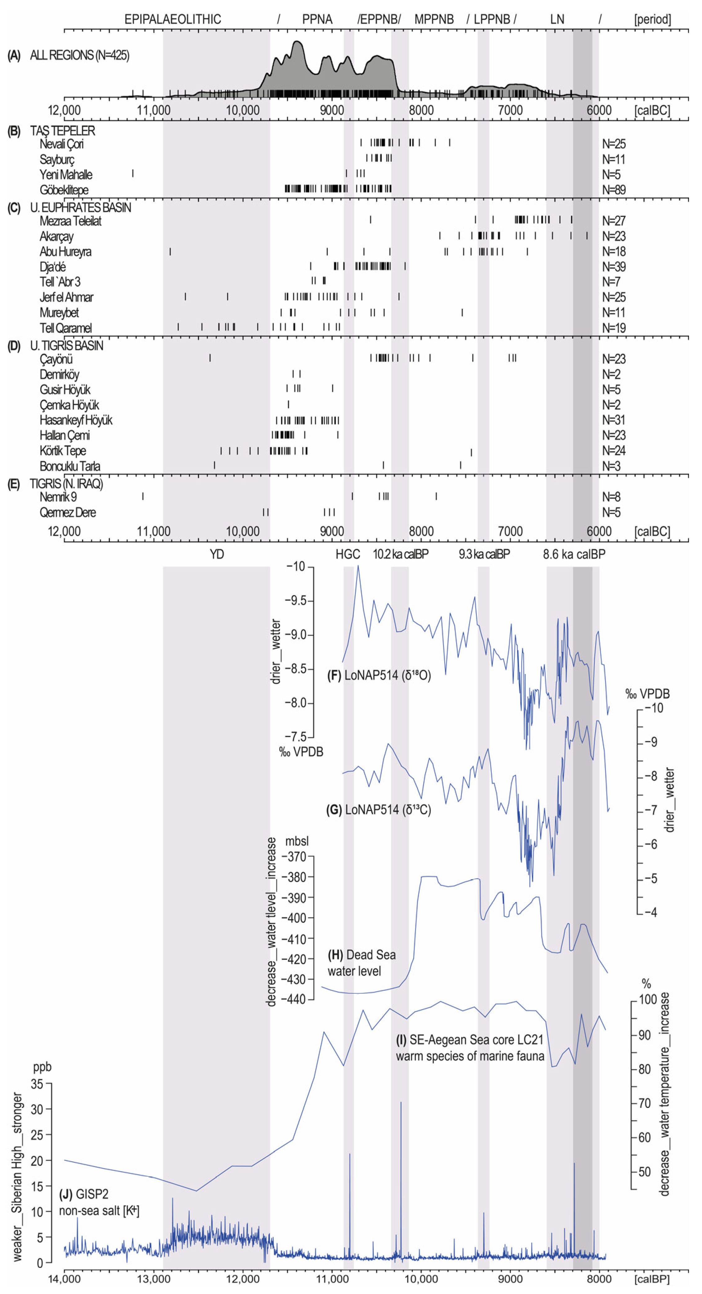
Figure 2 presents an overview of some palaeoclimate datasets from the Eastern Mediterranean. These datasets include stable isotopes (18O and 13C) from speleothems at the cave site LoNAP514 in the northern Kurdistan region of Iraq as a proxy for hydroclimate and vegetation type (Figure 2F,G) [102]; the Holocene water level of the Dead Sea as a proxy for precipitation levels (Figure 2H) [103]; the Aegean marine core LC21 (foraminiferal oxygen isotopes) as a proxy for marine surface water temperature (Figure 2I) [104]; and GISP2 potassium (terrestrial [K+]) ions from Greenland ice as a proxy for the occurrence and intensity of RCC intervals (Figure 2J) [92]. Figure 2B–E present radiocarbon (absolute) ages from 22 excavated archaeological sites in the study region (Table 1), while Figure 2A shows the summed probability distribution (SPD) for all these sites, thereby indicating potential demographic trends between the 11th and 9th millennia calBC [45,46,47]. Observations derived from comparisons of these datasets may indicate societal responses to climate change during the Late Pleistocene and the Early Holocene (EH).
It should be noted, however, that both the state of research and the quality and reliability of available radiocarbon measurements can constrain the interpretative value of SPDs, with additional pitfalls including calibration effects and sampling errors [48]. Consequently, prior to generating this figure, all radiocarbon determinations were systematically evaluated and filtered to exclude (1) measurements with standard deviations of ≥100 14C years and (2) obvious outliers. For Göbeklitepe, this also included the removal of dates obtained from bone, humic acids, and paedogenic carbonates, which have previously proven unreliable [14]. This filtering process resulted in the exclusion of 275 out of a total of 700 radiocarbon ages (Table 1 and Table S1). The remaining 425 dates were used to construct the SPD (Figure 2A) and are also depicted in the barcode-style calibrations for each individual site (Figure 2B–E).
Table 1. Overview of radiocarbon data, with information relating to excluded ages (and reasons for exclusion) of radiocarbon data used in Figure 2A–E [9,14,19,20,21,22,23,24,26,105,106,107,108,109,110,111,112,113,114,115,116,117,118,119,120,121,122,123,124,125,126,127,128,129,130,131]. A full list of the radiocarbon data, including excluded data and bibliographic sources, is provided in Table S1.
Archaeological SiteTotal 14C Ages (N)Excluded 14C Ages (N)/Reason
Taş Tepeler (Şanlıurfa, SE Türkiye)
Nevali Çori305/standard deviation
Sayburç110
Yeni Mahalle50
Göbeklitepe1411/outlier
31/bone
20/pedogenic carbon/humic acids
Upper Euphrates Basin (SE Türkiye; N Syria)
Mezraa Teleilat270
Akarçay263/standard deviation
Abu Hureyra6749/standard deviation
Dja‘dé476/standard deviation
2/outlier
Tell Abr‘370
Jerf el Ahmar261/standard deviation
Mureybet4230/standard deviation
1/outlier
Tell Qaramel5736/standard deviation
2/outlier
Upper Tigris Basin (SE Türkiye)
Çayönü4318/standard deviation
2/outlier
Demirköy20
Gusir Höyük50
Çemka Höyük20
Hasankeyf Höyük310
Hallan Çemi3815/standard deviation
Körtiktepe240
Boncuklu Tarla30
Tigris (N Iraq)
Nemrik 96052/standard deviation
Qermez Dere61/standard deviation
Figure 2. Barcode calibration of radiocarbon ages (N = 425) from 22 Pre-Pottery Neolithic sites in the upper Tigris and Euphrates basins (BE); the occurrence of some data in the Late Neolithic (LN) reflects the continuity of some sites into this subsequent period. In the barcode method, each vertical line represents the calibrated median value of one 14C age using IntCal20 calibration data [132]. All radiocarbon ages are filtered to exclude apparent outliers and ages with standard deviations exceeding ±99 14C years. An overview of the number of radiocarbon data (and excluded data) from each site is provided in Table 1. Full lists of the radiocarbon data, excluded data and reasons for their exclusion, together with bibliographic references, are provided in the supplement (Table S1). All data (A) shows the summed probability distribution (SPD) across all sites. Bottom: stable isotopes (18O and 13C) from speleothems at the cave site LoNAP514 in the northern Kurdistan region of Iraq (F,G) [102]; Holocene water level of the Dead Sea (H) [103]; Aegean marine core LC21 (marine fauna) (I) [104]; and GISP2 potassium (terrestrial [K+]) ions from Greenland ice (J) [92]. Grey bars indicate rapid climate change intervals (RCCs) in the Late Pleistocene and the Early Holocene, as well as other notable climate anomalies, including the Younger Dryas (YD) and the 8.2 ka calBP (Hudson Bay) event (dark grey bar). PPNA: Pre-Pottery Neolithic A; EPPNB: Early Pre-Pottery Neolithic B; MPPNB: Middle Pre-Pottery Neolithic B; LPPNB: Late Pre-Pottery Neolithic B; LN: Late Neolithic; YD: Younger Dryas; HGC: Hunter-Gatherer Crisis [95]. Graph compiled using CalPal 2024.7 [133]. Image: L. Clare, German Archaeological Institute.
Heritage 09 00179 g002
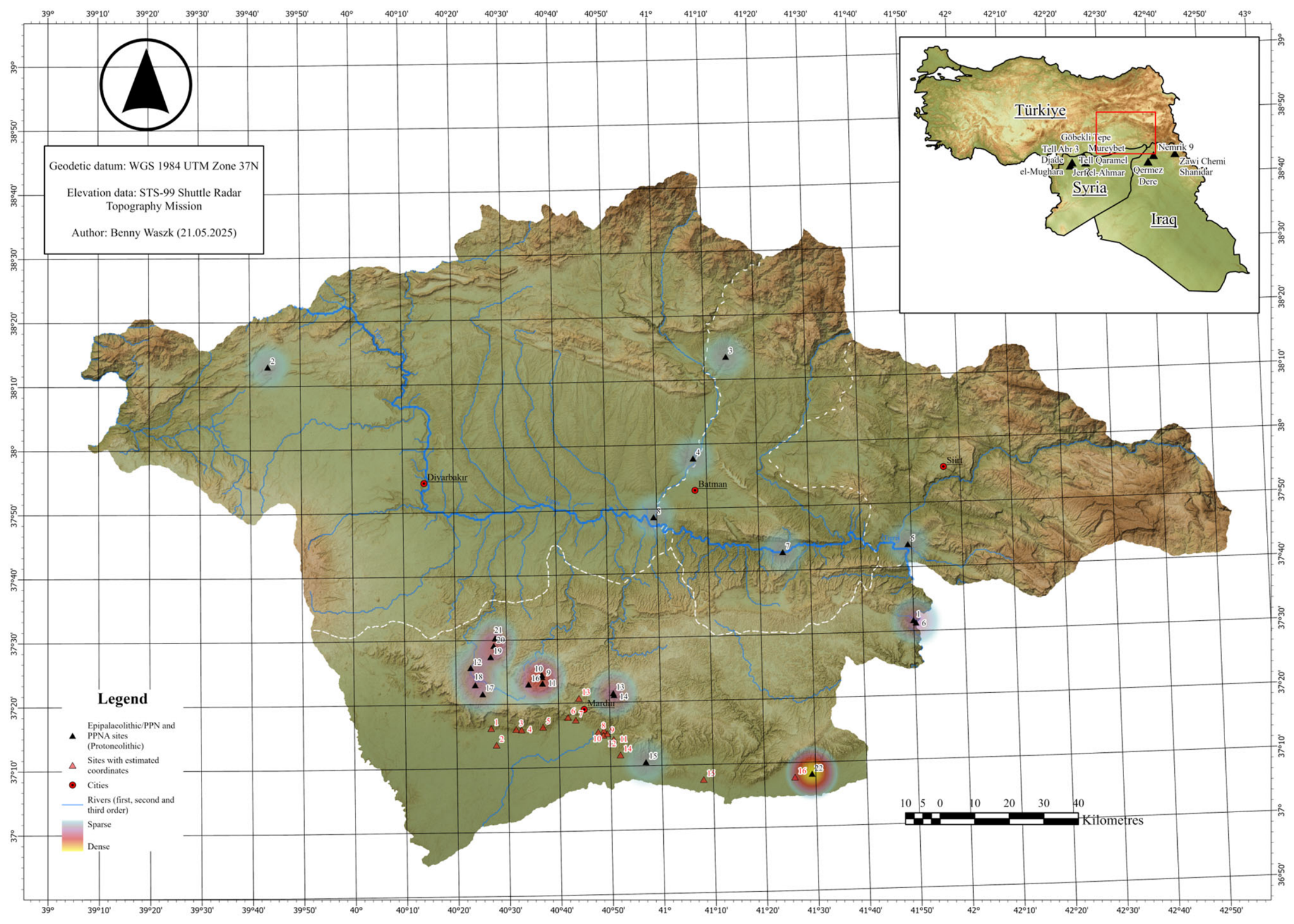
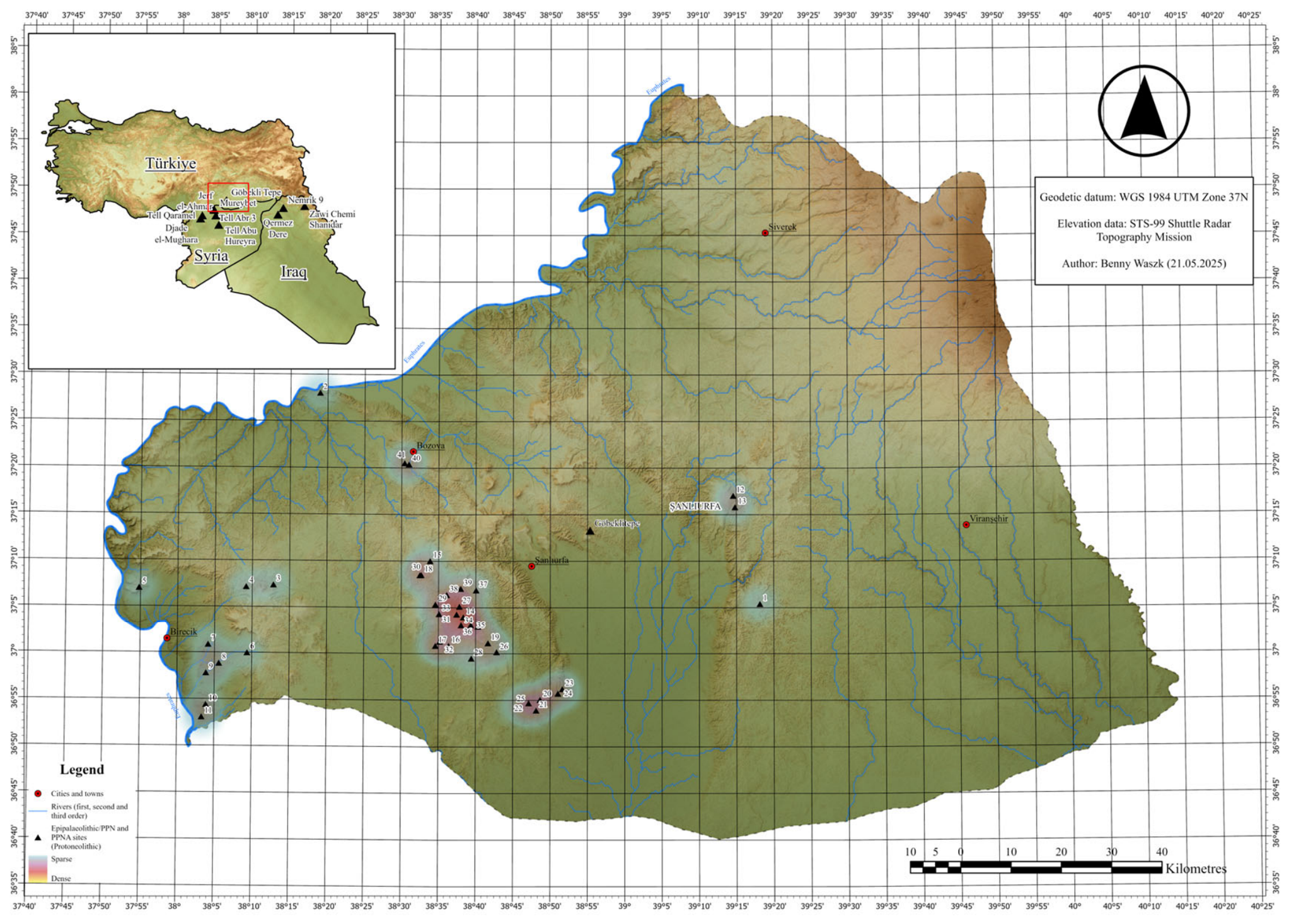
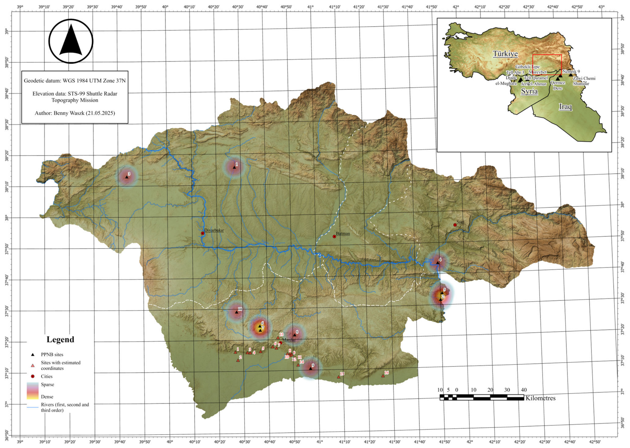
Epipalaeolithic: To date, seven sites in the study region have radiocarbon ages that fall within the YD; four are located along the upper Tigris, and three are settlements on the upper Euphrates (Figure 2C–E). The Tigris sites include Körtiktepe [21,134,135] and Boncuklu Tarla [23], where evidence for sedentary hunter-forager settlements begins in the late YD and continues into the EH (Figure 3). While the 14C age from Çayönü, for which an Epipalaeolithic settlement phase is unknown, is most likely an outlier, the two ages from Qermez Dere stem from an Epipalaeolithic-PPN transitional phase [26]. At Nemrik 9, all radiocarbon ages dating to the YD were excluded due to high standard deviations; however, the Epipalaeolithic (Zarzian) from the earliest layers of this site is attested through excavation [109]. Although not represented by radiocarbon ages, archaeological excavations at Çemka Höyük have also produced evidence of Epipalaeolithic occupations [22,136]. Along the upper Euphrates (Figure 4), the three settlements that have produced radiocarbon dates of YD age include Abu Hureyra, Jerf el Ahmar, and Tell Qaramel. Due to the high standard deviation of many of the Epipaleolithic ages from Abu Hureyra, all but one have been excluded from Figure 2 (Table 1). At Jerf el Ahmar, the YD ages are once again outliers, as the occupation at this settlement does not commence until after the Holocene transition [128]. At Mureybet, all 14C ages from the YD were disqualified due to high standard deviation; however, the occurrence of the Epipalaeolithic is confirmed through excavation [116]. At Tell Qaramel, the YD occupation is well-attested through 14C ages and material culture [20].
In the Upper Tigris Basin, additional evidence for YD sites comes from dedicated archaeological surface surveys in the Turkish province of Mardin, which have concentrated on the mountainous plateau landscape that separates the Tigris Valley in the north from the Upper Khabur Basin in the south. These surveys have culminated in the discovery of numerous archaeological sites (>150) from the Palaeolithic and the PPN, ranging from simple surface scatters to campsites, hunting traps (desert kites), caves, rock shelters and their terraces, and slope-settlements and mounds (Tr. höyük). Many of these sites are tentatively dated to the Epipalaeolithic/PPNA (Protoneolithic) based either on lithic assemblages or observed architectural features visible on the surface [137,138,139,140,141]. The comparative frequency and density of Protoneolithic sites in Mardin compared to the areas further west in Şanlıurfa is striking and could attest to adapted land-use strategies of a hitherto undocumented hunter-forager population from the Late Pleistocene and EH, referred to by E. Kodaş as the Dokane Culture [138].
There are still relatively few known Epipalaeolithic (YD) sites along the banks of the Euphrates on the Turkish side of the border and in the Taş Tepeler region around Şanlıurfa. Potential sites near the Euphrates include Biris Mazarlığı and Söğüt Tarlası [142,143], as well as Uluk Mevkii [144] and a few sites in the Birecik municipality [145]. In the western part of the Taş Tepeler region, several sites have yielded surface collections classified as Palaeolithic/PPN [146,147]. Furthermore, it is possible that Epipalaeolithic deposits remain hidden at some of the larger höyüks in the region. Therefore, YD conditions do not appear to have been entirely detrimental to human occupation in the upper Euphrates and Tigris basins, but a lack of dedicated palaeoclimatological studies in the region means that local environmental reconstructions heavily depend on bioarchaeological investigations from a limited number of excavated settlements, primarily Körtiktepe on the Tigris [21,82,135] and Abu Hureyra on the Euphrates [83].
The data from these sites indicate that the two river basins never presented a homogeneous environment, and subsistence strategies were adapted to prevailing local conditions. Generally, the YD dry woodland steppe habitat, dominated by Artemesia and Chenopodiaceae, was home to multiple animal species, especially red deer, mouflon and wild goat in the hillier landscape around Körtiktepe and gazelle in the Syrian Tableland at Abu Hureyra [79,83,135]. Additionally, the wetland environment was exploited at both settlements, as attested by various species of ducks, waders and raptors from the Tigris at Körtiktepe and freshwater mussels from the Euphrates at Abu Hureyra. Notably, different land-use models must also be postulated for the higher elevated areas around Mardin, where caves and cave terraces were more densely settled than previously thought. As with hunting, YD communities practised site-distinct plant exploitation strategies. At Abu Hureyra, wild rye was dominant in the archaeobotanical record, although there is little evidence for tilling [148]. In contrast, at Körtiktepe, widespread, dense stands of annual grasses, especially small-seeded species and riverine taxa, likely provided the staple plant foods for this population [82].
Figure 4. Map showing the distribution of Epipalaeolithic and PPNA (Protoneolithic) sites in Şanlıurfa province [144,145,147,149]. 1. Karahantepe, 2. Uluk Mevkii, 3. Kısakuyu Höyüğü, 4. Hayrat Mevkii Çevresi, 5. Tilmahmut Yatırı, 6. Mağaralı Dere, 7. Eske Harebe II, 8. Sınır Tepesi Höyüğü, 9. Girlavık Höyüğü I, 10. Kulbatar Kaya Sığınakları, 11. Camuz Tepe, 12. Sumaklı Köyü—Sumaklı Besta Faki Mevkii, 13. Sumaklı Köyü—İsmail Kalesi, 14. İkiztepe Buluntu Alanı, 15. Sesigür/Zengulup, 16. Haleklitaş, 17. Doğanlar/Tekyamaç, 18. Göbekli, 19. Gotik Tepesi, 20. Cudi Zeytini, 21. İkiz Kuş Yamaç Yerleşmesi, 22. Erken Yamaç Yerleşmesi, 23. Tahta Harabesi Kesimhane/Kamp Yerleşme, 24. Cudi Deresi Kesimhane/Kamp Yerleşmesi, 25. Hasmezra Yerleşimi, 26. Yanıkçöğür Açık Hava İstasyonu, 27. Çakmaktepe, 28. Nergislik Yamaç Yerleşmesi, 29. Eski Harabereler/Xrabete Qewın, 30. Ebu Abit Tepesi, 31. İki Ağız, 32. Oluk Yanı, 33. Tül Harabesi, 34. Borbore, 35. Mendiktepe, 36. Nur Tepe, 37. Şebeke Harebeleri, 38. Sayburç Bademi Höyük, 39. Sayburç Sanayi Mevkii, 40, Biris Mezarkığı, 41. Söğüt Tarlası. Image: B. Waszk, German Archaeological Institute.
Heritage 09 00179 g004
Pre-Pottery Neolithic A: In the EH, there is an increase in settlement activity in the study area (Figure 2A). In addition to the sites where occupations had already commenced during the YD, late hunter-forager populations were now settling at Demirköy, Gusir Höyük and Hasankeyf Höyük along the Tigris, Gre Fılla on the Ambar Çayı (a tributary of the Tigris), and at Jerf el Ahmar, Dja’dé and Tell ‘Abr 3 on the Euphrates. In the Taş Tepeler area, excavations at two sites have recently produced evidence of PPNA occupations at Çakmaktepe [10,18] and Mendiktepe [18]; earliest activities at Göbeklitepe and Karahantepe are also attested [16,18]. A larger number of excavated sites also means a greater abundance of bioarchaeological data. Especially at settlements with earlier Epipalaeolithic (YD) occupations, clear environmental changes can be noted. At Körtiktepe, although wide-spectrum hunting strategies continued, there were changes in the local environment reflected in different ratios of exploited wild animals; larger sized fish and an emphasis on the exploitation of waterfowl are indicative of changes to local waterways, and an increase in aurochs is suggestive of more marshland, with more wild boar remains implying gully side vegetation and oak forest [135]. On the other hand, specialised hunting of gazelle is attested in the Taş Tepeler region (Göbeklitepe) and at the northern Syrian and Iraqi sites [150]. In addition to the lack of evidence for ungulate management in the study area, there are no indications for the intensive exploitation of crop progenitor species [151], except perhaps at Mureybet, Jerf el Ahmar and Tell ‘Abr 3 in northern Syria (incipient pre-domestication cultivation) [152]. However, along the upper Tigris, as at Gusir Höyük, even wild cereals are absent in the PPNA, appearing only in the subsequent EPPNB. Sites such as Hasankeyf Höyük, Hallan Ҫemi and Demirköy were all sedentary hunter-gatherer sites where sedentism developed around hunter-gatherer-fisher systems. Generally speaking, the Epipalaeolithic and the PPNA can be assigned to a Protoneolithic phase, as presented in Figure 3 and Figure 4.
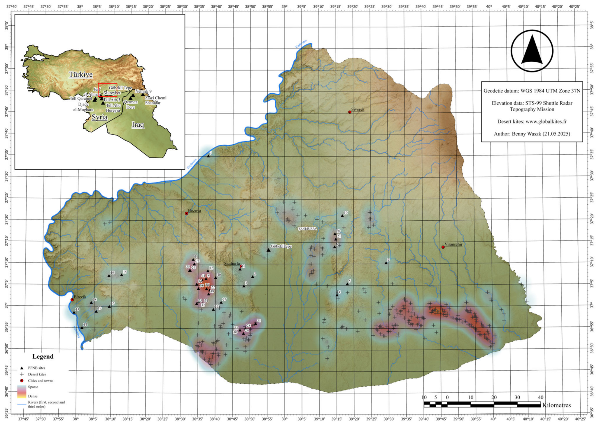
Early Pre-Pottery Neolithic B: By the late PPNA, a detectable depopulation was taking place along the upper Tigris and Euphrates rivers (Figure 2A,C), accompanied by a quasi-contemporaneous surge in EPPNB sites in Şanlıurfa (Figure 2B, Figure 5 and Figure 6), a trend previously referred to as the hunter-gatherer crisis (HGC) [43,95]. In the coming years, an even greater increase in the EPPNB signal of the SPD can be expected as more 14C ages become available from the Taş Tepeler project. The causal mechanisms behind this demographic shift remain elusive; the only indication that it could be related to climate comes from (non-local) palaeoclimate proxy data (Figure 2H,J), which hint at a short-lived RCC interval at approximately 8800 calBC. However, given the lack of local paleoclimate proxy data and the absence of attested impacts on the local environment, this conclusion remains tentative. Archaeological surveys in the study region have also led to the discovery of numerous (N = 289) prehistoric hunting traps, so-called desert kites (see https://www.globalkites.fr (accessed on 23 March 2026)), for which it is currently unknown whether these were constructed over a large space of time (Epipalaeolithic-PPNA-PPNB) or are attributable only to the EPPNB, thus reflecting either the increased demands of a growing population from the early 9th millennium calBC [146,147,153,154,155] and/or the practice of meat caching as a buffer for times of scarcity [156]. Alternatively, the high number of traps may reflect shifts in the migration routes of animals, such as gazelles, over time and could also testify to the use of hunting dogs [43]. Whatever the case, the high work investment required suggests that these projects either contributed to the consolidation of regional cooperations or that they are a testimony to the challenges faced by different groups as they competed for resources and access to the landscape [157]. The EPPNB is also noted as the period in which the first morphologically domesticated einkorn wheat is observed at Nevali Çori [152], together with the possible breeding in captivity of sheep, pigs, and goats [114]. However, Nevali Çori is an outlier, as no other sites have thus far produced similar evidence. On the whole, in the EPPNB (and MPPNB), there was a coexistence of foraging-focused and crop-dominated strategies, as well as mixed subsistence economies; however, for the most part, crops still appear closer to their morphologically wild forms.
Middle Pre-Pottery Neolithic B: The number of settlements declines markedly during the MPPNB (Figure 2A). Notably, this trend contradicts earlier conclusions by Roberts et al. [45], who identified an initial demographic increase in southern Türkiye beginning around 10,300 calBP. The transition from the EPPNB to the MPPNB also coincides with the 10,200 calBP climatic event, which is thought to have involved highly variable and extreme weather conditions, including harsher winters, anomalous precipitation regimes, and recurrent droughts, often occurring in successive years [61,91]. Indeed, B. Weninger [96] has suggested that the 10,200 calBP RCC coincides with the earliest appearance of domesticated barley and cattle at several sites in the region and may be causally linked to these developments. However, although a few MPPNB sites exhibit a shift toward more agricultural practices, such cases remain exceptional rather than representative of broader subsistence patterns. It is only during the Late (Pottery) Neolithic that a substantial shift toward crop-dominated economies becomes apparent [152].
Turning to the available palaeoclimate proxies spanning the 10200 calBP RCC interval, a rise in the water level of the Dead Sea may indicate elevated precipitation levels across the Eastern Mediterranean during this period (Figure 2H). Indeed, the influence of RCCs on the northern periphery of the Fertile Crescent is underscored by the speleothem record from LoNAP514 in northern Iraqi Kurdistan (Figure 2F–G) [102]; this cave lies comparatively close to the upper Euphrates and Tigris basins, approximately 170 km southeast of the Ilısu Dam area (Boncuklu Tarla, Çemka Höyük) and 400 km east–southeast of Göbeklitepe. However, while all RCC intervals (Figure 2, grey bars) correspond to low water levels in the Dead Sea (Figure 2H) [103] and cooling sea-surface temperatures in the Aegean (Figure 2I) [104], the LoNAP514 oxygen-isotope record displays a more complex pattern. It indicates increasing aridity at 10,200 calBP and contradictory signals at 9300 calBP, while the alternating wet and arid phases between 8600 and 8000 calBP may either reflect the intrinsic variability of RCC conditions or point to pronounced micro-regional climatic heterogeneity.

8. Human–Environment Interactions in the Tigris and Euphrates Basins: Insights from Adaptive Cycles and Vulnerability

Based on the admittedly limited empirical data from the study area, including available radiocarbon ages (SPD) and settlement counts, it has previously been suggested that each of the periods considered in this contribution could be assigned to a phase of an adaptive cycle: Epipalaeolithic (α), PPNA (r), EPPNB (K) and MPPNB/LPPNB (Ω) [43]. Any assignment of prehistoric periods must remain tentative, given the spatial gaps in surface survey work and the difficulty of reliably dating surface sites. Whereas adaptive cycles can inform us about when socioeconomic systems are most resilient and most at risk of abrupt climate change intervals, vulnerability studies can guide us in identifying the potential background factors that contribute to their respective resilience levels.
As the α phase is the starting point of the cycle, it is characterised by the establishment of new residential, descendant and heritage rules, the construction of new traditions, and high vertical social mobility. Although open to external influences, which are advantageous for spatial (demographic) dispersal, socioeconomic systems are still subject to manifold, ongoing transitional processes, rendering them inherently unstable; for this reason, they remain vulnerable to external perturbations, still lacking the essential buffering mechanisms.
In contrast, the r (PPNA) and K (EPPNB) phases are the most resilient to external climatic perturbations. The r phase is a time of growth and interaction, with vulnerability levels decreasing to their lowest point in the adaptive cycle. This phase is synonymous with demographic expansion and yield optimisation. In small-scale societies, social differentiation can be legitimised through kinship ties and cultural homogeneity, and newly emerging kinship institutions ensure the balanced distribution of resources throughout the community (access to assets), resulting in the higher resilience of the entire system. The subsequent K phase is marked by low vertical social mobility, culminating in social tensions (reduced access to assets) and a rigid reference to traditions. Slightly higher levels of vulnerability are now discernible, attributed to a decreasing density in large-scale communication (increasing regionalisation) due to the gradual disbandment of the previous cultural homogeneity. Therefore, given the very weak palaeoclimate evidence for RCC during the hunter-gatherer crisis (early 9th millennium calBC) and the potentially high resilience of the socioeconomic system at that time (late PPNA-early EPPNB), it is unlikely that the HGC was related to climate change and that the observable developments in the archaeological record were more likely of a cultural origin.
The Ω phase marks the downswing in the adaptive cycle. It is characterised by the loss of traditional values and a distorted or failed legitimisation of systems; frequently associated with emigration, this phase is the most vulnerable as systems are at their weakest. Interestingly, the earlier assignment of the MPPNB to the Ω phase and its temporal coincidence with the decline and abandonment of the Taş Tepeler sites suggest that the prevailing system was especially vulnerable (biophysically and socially) at this time and that the climate instability associated with the 10,200 calBP event could have contributed to the collapse of the PPN monumental sites, such as at Göbeklitepe and Karahantepe.

9. Göbeklitepe in Palaeoclimate Context

Against the background of the palaeoclimate record, three milestones in the archaeological sequence of Göbeklitepe can be considered which coincided with or were subsequent to intervals of climate change; these include (1) the foundation of the settlement following the YD, during EH climate amelioration; (2) the inundation of parts of the site by slope-slides during the HGC; and (3) abandonment processes in the contexts of the RCC interval at 10,200 calBP.
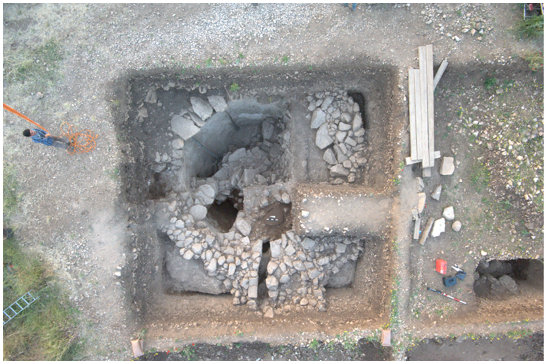
According to the earliest reliable radiocarbon dates, initial (PPNA) occupations date back to the mid-10th millennium calBC. In this respect, Göbeklitepe is just one of many settlements in the upper Euphrates and Tigris basins that appeared during this period. As noted, the r phase of the adaptive cycle, to which the PPNA has been assigned, is a time of growth and interaction and is synonymous with demographic expansion and yield optimisation. With excellent views over the surrounding landscape and situated at a key thoroughfare for gazelle herds, the site offered hunter-gatherer groups numerous advantages, encouraging initial occupation [150]. In addition to the early phases of the special buildings, this earliest settlement phase features round-oval dwellings, typical of the period, constructed directly on (or just above) the natural limestone plateau [14,158]; however, it remains unclear when the transition to potential semi- to full-sedentism occurred. Climate change likely played a part in this initial settlement process, as a (semi-) permanent occupation at this location may only have become possible due to increased rainfall. In the absence of natural springs, for which there is currently no evidence, rainwater-harvesting using channels and cisterns carved from the natural limestone plateau would have been the only way of securing the water supply. Although not dated with confidence, examples of cisterns are known not only from the surrounding plateau of the site but also from internal settlement areas [13,159] (Figure 7).
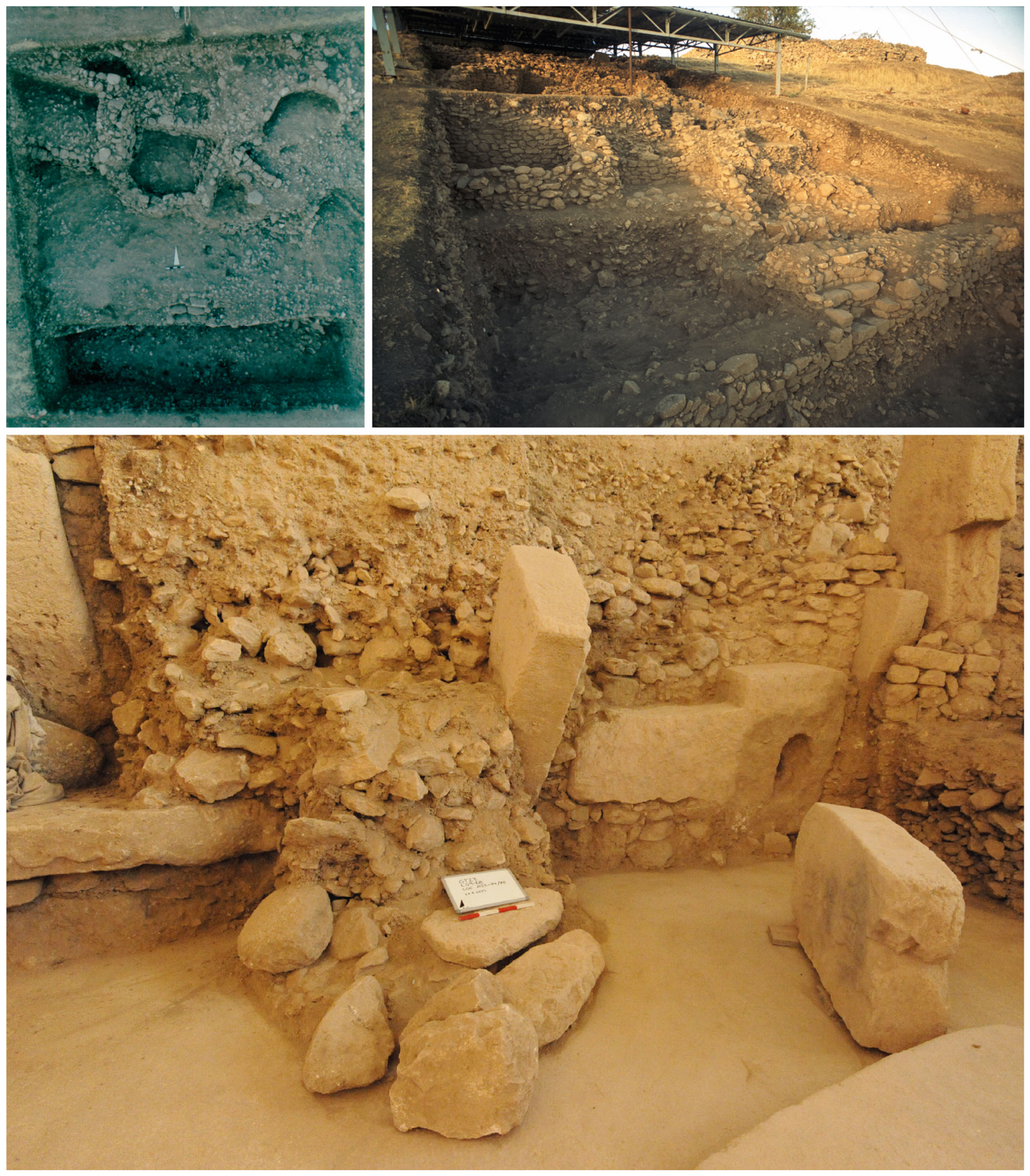
The onset of the EPPNB at Göbeklitepe saw the site enter its most densely occupied phase. The appearance of increasingly rectangular and trapezoid-shaped structures could be explained as a more economical approach to utilising available space, especially considering that the inhabitants of these buildings seemed to be competing over the proximity of their dwellings to the special buildings. Over time, in the southeastern part of the site, this led to the formation of tell deposits on the slopes surrounding the special buildings, which had been constructed on an area of lower-lying natural bedrock. Earlier excavations had already revealed that by the PPNB, the slopes overlooking the special buildings had become inherently unstable, as evidenced by the construction of retaining terrace walls (Figure 8). Nevertheless, recent studies have demonstrated that the slopes indeed slipped on more than one occasion, leading to considerable destruction in this part of the site, including the inundation of the special buildings with mixed PPNA and EPPNB deposits [160]. The question remains as to the role of abrupt climate change in this process; certainly, increased levels of rainfall or heavy snows connected with RCC (HGC/10.2 ka calBP event) may have, on occasion, increased the weight of the slope, thus promoting slippage. It is, however, more likely that seismic events played a more significant part in weakening the slope fabric, as evidenced by the detected earthquake damage in numerous buildings [160]. Although the EPPNB has been assigned to the K phase of the adaptive cycle, generally characterised by lower levels of vulnerability, it appears, at least in this very special case, that the behaviour and (building) traditions of the inhabitants had increased their susceptibility to be impacted by natural disasters.
Currently, there are no absolute radiocarbon dates for the final settlement phase at Göbeklitepe. This absence reflects a lack of organic samples from post-EPPNB contexts at the site, a gap that will be addressed in upcoming seasons. However, despite the absence of radiocarbon dates, there is architectural and stratigraphic evidence of post-10.2 ka calBP occupation at the site; notably, this phase saw a return to smaller and more round-oval-shaped spaces, which appear to have been scattered throughout the ruins of the settlement, stratigraphically above EPPNB structures, perhaps serving as shelters for ruin dwellers or squatters [160]. The processes leading to the (gradual) abandonment of the site could be linked to numerous factors, including unsafe conditions due to erosion, further exacerbated by RCC conditions, earthquake impacts, and changes in subsistence strategies and socioeconomic systems. Indeed, Göbeklitepe was not the only site to have been abandoned at this time, as the focus of settlement in the area shifted from the hilly and rocky areas around Şanlıurfa to the Harran plain (Gürcütepe) and the Euphrates River Valley (Akarçay and Mezraa Teleilat).

10. Conclusions

Although no claims of causality can be made, the overlap of abrupt climate change, settlement dynamics, and socioeconomic developments in the archaeological record represents the first step towards identifying any such relationships. At this point, a significantly more crucial task is to identify periods when socioeconomic systems were more vulnerable to climate-induced hazards, thereby warranting further investigations, particularly if these coincide with known climatic perturbations. Some notable observations can now be drawn regarding potential human responses to abrupt climate change in the upper Euphrates and Tigris basins from the YD to the EH:
  • In contrast to the Southern Levant, where the milder and moister conditions of the Bølling-Ållerød interstadial had already promoted sedentism, there are no indications of this development in the upper Tigris and Euphrates basins, where sedentary lifeways among hunter-gatherer populations first become visible in the YD climate reversal. This process unfolded against inherently unstable socioeconomic systems, as characteristic of an α phase in the adaptive cycle, which, nevertheless, proved advantageous for spatial (demographic) dispersal.
  • The PPNA saw the adaptation of Epipalaeolithic (YD) subsistence strategies to the emerging EH environments. Climate amelioration at the onset of the Early Holocene was accompanied by an increase in the number of settlements and, consequently, population growth. The earliest settlements in the Taş Tepeler (also at Göbeklitepe) indicate that sedentism and associated socioeconomic systems had become established in this area, in line with the r phase of the adaptive cycle, when growth and interaction occur, with vulnerability levels decreasing to their lowest point. In small-scale societies, social differentiation becomes legitimised through kinship ties and cultural homogeneity. As such, this phase sets the stage for the subsequent EPPNB, when the large central sites, such as Göbeklitepe and Karahantepe, reach their demographic and cultural pinnacles.
  • The transition from PPNA to EPPNB is synonymous with the HGC, which coincided with a shift in material culture and settlement patterns. According to the model, the socioeconomic systems of the PPNA were already more resilient than those of the Epipalaeolithic and the EPPNB (K phase) even more so, meaning that communities would have been better able to cope with external impacts, including adverse (RCC) climate conditions. Despite the low vulnerability, this was the period which saw major changes in settlement patterns, including the abandonment of numerous sites along the Tigris and an explosion of (T-pillar) sites around Şanlıurfa. However, the palaeoclimate evidence for an RCC interval in the early part of the 9th millennium calBC remains weak; as such, the reasons behind the changes should probably be sought elsewhere.
  • Based on the available radiocarbon evidence, the 10.2 ka calBP event may have contributed to the social collapse in the MPPNB. The RCC interval coincides sharply with the rapid drop in available radiocarbon ages, perhaps suggesting that it would have impacted the more resilient part of the adaptive cycle (EPPNB; K phase) rather than its most vulnerable part (MPPNB; Ω phase). This can mean one of three things: (1) despite their high resilience, the impacts of the RCC at 8200 calBC were so severe that EPPNB buffering mechanisms were inadequate and unable to cope; (2) the available radiocarbon ages are still too few to sufficiently place the onset of the RCC interval in the archaeological sequence; or (3) the transition from EPPNB to MPPNB was not climate-related. At Göbeklitepe, the settlement was impacted by a series of slope slides, possibly triggered by earthquakes combined with the adverse effects of heavy rain and/or snowfall (erosional processes) associated with this RCC interval.

Supplementary Materials

The following supporting information can be downloaded at: https://www.mdpi.com/article/10.3390/heritage9050179/s1, Table S1: Radiocarbon data from Pre-Pottery Neolithic sites in the upper Tigris and Euphrates basins used in this study. Refs. [161,162,163,164,165,166,167,168,169,170,171,172,173,174,175,176,177,178] have been cited in Supplementary File.

Funding

Until August 2025, archaeological fieldwork and research at Göbeklitepe were funded by the German Research Foundation (Deutsche Forschungsgemeinschaft, DFG) in the framework of the long-term funding project ‘The Prehistoric Societies of Upper Mesopotamia and their Subsistence’ (project number: 165831460).

Data Availability Statement

No new data are presented in this paper; all sources of data used are cited.

Acknowledgments

Research at Göbeklitepe would not be possible without the support of the General Directorate of Cultural Assets and Museums, the Ministry of Culture and Tourism of the Republic of Türkiye, the excavation director of Göbeklitepe and Karahantepe, Necmi Karul (Istanbul University), and the Şanlıurfa Museum, with its director, Celal Uludağ. I also thank Sharon Steadman (State University of New York) and John Haldon (Princeton University) for their invitation to contribute to this Special Issue of the Heritage Journal. I am also indebted to Benny Waszk for preparing Figure 3, Figure 4, Figure 5 and Figure 6. Finally, I would like to thank the anonymous reviewers for their comments, which helped to greatly improve this manuscript.

Conflicts of Interest

The author declares no conflicts of interest.

Abbreviations

The following abbreviations are used in this manuscript:
calBCcalibrated Before Christ
calBPcalibrated Before Present
EHEarly Holocene
PPNAPre-Pottery Neolithic A
EPPNBEarly Pre-Pottery Neolithic B
HGCHunter-Gatherer Crisis
LIALittle Ice Age
LNLate Neolithic
LPPNBLate Pre-Pottery Neolithic B
MPPNBMiddle Pre-Pottery Neolithic B
PPNPre-Pottery Neolithic
PPNBPre-Pottery Neolithic B
RCCRapid Climate Change
SPDSummed Probability Distribution
YDYounger Dryas
yr b2kYears before AD 2000

References

  1. Hauptmann, H. The Urfa Region. In The Neolithic in Turkey. New Excavations and New Research. Volume 2, The Euphrates Basin; Özdoğan, M., Başgelen, N., Kuniholm, P., Eds.; Archaeology & Arts Publications: Istanbul, Turkey, 2011; pp. 85–138. [Google Scholar]
  2. Özdoğan, M. Emergence and Dispersal of Neolithic Lifeways: From Core to Peripheries. In The Epipalaeolithic and Neolithic in the Eastern Fertile Crescent: Revisiting the Hilly Flanks; Richter, T., Darabi, H., Eds.; Routledge: Abingdon, UK, 2024; pp. 35–56. [Google Scholar]
  3. Karul, N. Şanlıurfa Neolitik Çağ Araştırmaları Projesi: Taş Tepeler. Arkeol. Sanat 2022, 169, VII–XIV. [Google Scholar]
  4. Çelik, B. A small-scale cult centre in Southeast Turkey: Harbetsuvan Tepesi. Doc. Praehist. 2016, 43, 421–428. [Google Scholar] [CrossRef] [Scilit]
  5. Çelik, B. Neolitik Dönem Kült Merkezi: Harbetsuvan Tepesi. Karadeniz Uluslararası Bilimsel Dergi 2019, 43, 24–38. [Google Scholar] [CrossRef] [Scilit]
  6. Güldoğan, E.; Uludağ, C. ‘Taş Tepeler’ Projesisin Doğudaki Sınır Yerleşmesi Sfertepe: İlk Sonuçlar. Arkeol. Sanat 2022, 171, 13–26. [Google Scholar]
  7. Özdoğan, E. The Sayburç reliefs: A narrative scene from the Neolithic. Antiquity 2022, 96, 1599–1605. [Google Scholar] [CrossRef] [Scilit]
  8. Çelik, B.; Tosyagülü Çelik, H. Harbetsuvan Tepesi 2017–2019 Yılı Buluntularına Toplu Bir Bakış. Arkeol. Sanat 2023, 173, 33–46. [Google Scholar]
  9. Özdoğan, E. Sayburç a mid-9th millennium BC site in the foothills of the Eastern Taurus. Doc. Praehist. 2024, 51, 44–58. [Google Scholar] [CrossRef] [Scilit]
  10. Şahin, F.; Miyake, Y. Çakmaktepe’den Avcı-Toplayıcı Yerleşiklere Dair Yeni Veriler. Arkeol. Derg. 2025, 1, 1–28. [Google Scholar] [CrossRef] [Scilit]
  11. Schmidt, K. »Zuerst kam der Tempel, dann die Stadt« Vorläufiger Bericht zu den Grabungen am Göbekli Tepe und am Gürcütepe 1995–1999. Istanbuler Mitteil. 2000, 50, 5–41. [Google Scholar]
  12. Schmidt, K. Sie Bauten die Ersten Tempel. In Das Rätselhafte Heiligtum der Steinzeitjäger; C.H. Beck: München, Germany, 2006. [Google Scholar]
  13. Clare, L. Göbekli Tepe, Turkey. A brief summary of research at a new World Heritage Site (2015–2019). e-Forschungsberichte 2020, 81–88. [Google Scholar] [CrossRef]
  14. Kinzel, M.; Clare, L. Monumental—Compared to what? A perspective from Göbekli Tepe. In Monumentalising Life in the Neolithic. Narratives of Change and Continuity; Gebauer, A.B., Sørensen, L., Teather, A., Valera, A.C., Eds.; Oxbow Books: Oxford, UK; Philadelphia, PA, USA, 2020; pp. 29–48. [Google Scholar]
  15. Karul, N. Buried Buildings at Pre-Pottery Neolithic Karahantepe. Türk Arkeol. Etnogr. Derg. 2021, 82, 21–31. [Google Scholar]
  16. Karul, N. Karahantepe Çalışmalarına Genel Bir Bakış. Arkeol. Sanat 2022, 169, 1–8. [Google Scholar]
  17. Erdalkıran, M. Harran Ovası’nın İlk Çiftçileri. Gürcütepe. ŞURKAV Şanlıurfa Kültür Sanat Tar. Tur. Derg. 2023, 45, 28–35. [Google Scholar]
  18. Karul, N.; Baird, D.; Clare, L.; Erdalkıran, M.; Güldoğan, E.; Miyake, Y.; Özdoğan, E.; Shimogama, K.; Şahin, F.; Uludağ, C. Şanlıurfa Neolitik Çağ Arıştırmaları Projesi Taş Tepeler: Son Çalişmalar, Yeni Sonuçlar. In Geleceğe Miras. Türkiye Arkeolojisinin Altın Çağı; Engin, A., Özçelik, K., Çokay Kepçe, Ş.S., Tekinalp, V.M., Yıldırım, F., Özturan, M., Eds.; T.C. Kültür ve Turizm Bakanlığı ve Müzeler Genel Müdürlüğü, Özel Ofset: Ankara, Turkey, 2025; Volume I, pp. 53–88. [Google Scholar]
  19. Moore, A.M.T.; Hillman, G.C.; Legge, A.J. Village on the Euphrates: From Foraging to Farming at Abu Hureyra; Oxford University Press: London, UK, 2000. [Google Scholar]
  20. Mazurowski, R.F.; Michczyńska, D.J.; Pazdur, A.; Piotrowska, N. Chronology of the Early Pre-Pottery Neolithic Settlement Tell Qaramel, Northern Syria, in the Light of Radiocarbon Dating. Radiocarbon 2009, 51, 771–781. [Google Scholar] [CrossRef] [Scilit]
  21. Coşkun, A.; Benz, M.; Rössner, C.; Deckers, K.; Riehl, S.; Alt, K.W.; Özkaya, V. New Results on the Younger Dryas Occupation at Körtik Tepe. Neo-Lithics 2012, 1/12, 25–32. [Google Scholar]
  22. Kodaş, E.; Genç, B.; Çiftçi, Y.; Labedan-Kodaş, C.; Erdem, Ç. Çemka Höyük: A Late Epipalaeoltihic and Pre-Pottery Neolithic Site on the Upper Tigiris, Southeast Anatolia. Neo-Lithics 2020, 20, 40–46. [Google Scholar]
  23. Kodaş, E. The Younger Dryas layer at Boncuklu Tarla and the beginning of village life in the upper Tigris Basin. Archaeol. Res. Asia 2023, 35, 100460. [Google Scholar] [CrossRef] [Scilit]
  24. Miyake, Y.; Maeda, O.; Tanno, K.; Hongo, H.; Gündem, C.Y. New Excavations at Hasankeyf Höyük: A 10th millennium cal. BC site on the Upper Tigris, Southeast Anatolia. Neo-Lithics 2012, 1/12, 3–7. [Google Scholar]
  25. Karul, N. The beginning of the Neolithic in southeast Anatolia: Upper Tigris Basin. Doc. Praehist. 2020, 47, 76–95. [Google Scholar] [CrossRef] [Scilit]
  26. Watkins, T.; Betts, A.; Dobney, K.; Nesbitt, M. Qermez Dere, Tel Afar: Interim Report No 3; Department of Archaeology, University of Edinburgh: Edinburgh, UK, 1995; Volume 14. [Google Scholar]
  27. Rosenberg, M.; İnal, N. Soundings at Demirköy Höyük. In 20. Kazı Sonuçları Toplantısı. 25–29 Mayıs 1998, Tarsus; Olşen, K., Çakmak, H., Bayram, F., Tarlan, N., Özme, A., Ataş, K., Dönmez, H., Eds.; T.C. Kültür ve Turizm Bakanlığı, Kültür Varlıkları ve Müzeler Genel Müdürlüğü: Ankara, Turkey, 1999; Volume 1, pp. 249–257. [Google Scholar]
  28. Rosenberg, M.; Redding, R.W. Hallan Çemi and Early Village Organization in Eastern Anatolia. In Life in Neolithic Farming Communities: Social Organization, Identitiy, and Differentiation; Kuijt, I., Ed.; Kluwer Academic/Plenum Publishers: New York, NY, USA, 2000; pp. 39–61. [Google Scholar]
  29. Kozłowski, S.K. Nemrik: An Aceramic Village in Northern Iraq; Institute of Archaeology, Warsaw University: Warsaw, Poland, 2002. [Google Scholar]
  30. Erim-Özdoğan, A. Çayönü. In The Neolithic in Turkey. New Excavations & New Research. Volume 1, The Tigris Basin; Özdoğan, M., Başgelen, N., Kuniholm, P., Eds.; Archaeology & Art Publications: Istanbul, Turkey, 2011; pp. 185–269. [Google Scholar]
  31. Cutter, S.L. Vulnerability and environmental hazards. Prog. Hum. Geogr. 1996, 20, 529–539. [Google Scholar] [CrossRef] [Scilit]
  32. Adger, W.N.; Kelly, P.M. Social Vulnerability to Climate Change and the Architecture of Entitlements. Mitig. Adapt. Strateg. Glob. Change 1999, 4, 253–266. [Google Scholar] [CrossRef] [Scilit]
  33. Kelly, P.M.; Adger, W.N. Theory and Practice in Assessing Vulnerability to Climate Change and Facilitating Adaptation. Clim. Change 2000, 47, 325–352. [Google Scholar] [CrossRef] [Scilit]
  34. Blaikie, P.; Cannon, T.; Davis, I.; Wisner, B. At Risk: Natural Hazards, People’s Vulnerability and Disasters, 2nd ed.; Routledge: London, UK; New York, NY, USA, 2004. [Google Scholar]
  35. Hilhorst, D.; Bankoff, G. Mapping Vulnerability. In Mapping Vulnerability: Disasters, Development and People; Bankoff, G., Frerks, G., Hilhorst, D., Eds.; Earthscan: London, UK; Sterling, VA, USA, 2004; pp. 1–9. [Google Scholar]
  36. Füssel, H.-M.; Klein, R.J.T. Climate Change Vulnerability Assessments: An Evolution of Conceptual Thinking. Clim. Change 2006, 75, 301–329. [Google Scholar] [CrossRef] [Scilit]
  37. Bankoff, G. Historical concepts of disaster and risk. In Handbook of Hazards and Disaster Risk Reduction; Wisner, B., Gaillard, J.C., Kelman, I., Eds.; Routledge: London, UK, 2012; pp. 31–41. [Google Scholar]
  38. Redman, C.L. Resilience Theory in Archaeology. Am. Anthropol. 2005, 107, 70–77. [Google Scholar] [CrossRef] [Scilit]
  39. Gunderson, L.H.; Holling, C.S. Panarchy: Understanding Transformations in Human and Natural Systems; Island Press: Washington, DC, USA, 2002. [Google Scholar]
  40. Bradtmöller, M.; Grimm, S.; Riel-Salvatore, J. Resilience theory in archaeological practice—An annotated review. Quat. Int. 2016, 446, 3–16. [Google Scholar] [CrossRef] [Scilit]
  41. Schmidt, K. Investigations in the Upper Mesopotamian Early Neolithic: Göbekli Tepe and Gürcütepe. Neo-Lithics 1995, 2/95, 9–10. [Google Scholar]
  42. Clare, L.; Tuna Yüncü, Z.; Uludağ, C. Göbekli Tepe. In UNESCO World Heritage in Turkey; Ertürk, N., Karakul Türk, Ö., Eds.; UNESCO Türkiye Milli Komisyonu: Ankara, Turkey, 2019; pp. 522–547. [Google Scholar]
  43. Clare, L. Inspired individuals and charismatic leaders: Hunter-gatherer crisis and the rise and fall of invisible decision-makers at Göbeklitepe. Doc. Praehist. 2024, 51, 6–43. [Google Scholar] [CrossRef] [Scilit]
  44. Peters, J.; Schmidt, K.; Dietrich, L.; Dietrich, O.; Pöllath, N.; Kinzel, M.; Clare, L. Göbekli Tepe: Agriculture and Domestication. In Encyclopedia of Global Archaeology; Springer: Cham, Switzerland, 2019. [Google Scholar] [CrossRef] [Scilit]
  45. Roberts, N.; Woodbridge, J.; Palmisano, A.; Bevan, A.; Fyfe, R.; Shennan, S. Mediterranean landscape change during the Holocene: Synthesis, comparison and regional trends in population, land cover and climate. Holocene 2019, 29, 923–937. [Google Scholar] [CrossRef] [Scilit]
  46. van Maldegem, E.; Lauryssen, F.; Smolders, E.; Crombé, P. Beyond the sum: Evaluating the potential and limitations of analysing Neolithic population dynamics based on fluctuations in radiocarbon dates and sites (Scheldt basin, Northern France and Belgium). Doc. Praehist. 2024, 51, 194–218. [Google Scholar] [CrossRef] [Scilit]
  47. Bunbury, M.M.E. Towards Robust Demographic Models: A Systematic Framework to 14C Data Aggregation and Analysis with Lessons from the Southern Levant. J. Open Archaeol. Data 2025, 13, 3. [Google Scholar] [CrossRef] [Scilit]
  48. Crema, E.R. Statistical Inference of Prehistoric Demography from Frequency Distributions of Radiocarbon Dates: A Review and a Guide for the Perplexed. J. Archaeol. Method Theory 2022, 29, 1387–1418. [Google Scholar] [CrossRef] [Scilit]
  49. Maher, L.A.; Banning, E.B.; Chazan, M. Oasis or Mirage? Assessing the Role of Abrupt Climate Change in the Prehistory of the Southern Levant. Camb. Archaeol. J. 2011, 21, 1–30. [Google Scholar] [CrossRef] [Scilit]
  50. Lespez, L. Les déterminismes environnementaux: Approche critique et alternatives pour comprendre les relations des sociétés pré- et protohistoriques avec leur environnement [Environmental determinism: A critical perspective and new approaches to understanding the relationship between pre- and protohistoric societies and their environment]. Bull. Soc. Préhist. Fr. 2025, 122, 95–123. [Google Scholar]
  51. Steward, J.H. Theory of Culture Change: The Methodology of Multilinear Evolution; University of Illinois Press: Urbana, IL, USA, 1955. [Google Scholar]
  52. Ordonez, A.; Riede, F. Changes in limiting factors for forager population dynamics in Europe across the last glacial-interglacial transition. Nat. Commun. 2022, 13, 5140. [Google Scholar] [CrossRef] [Scilit] [PubMed]
  53. Safaierad, R.; Matthews, R.; Dupont, L.; Zolitschka, B.; Marinova, E.; Djamali, M.; Vogt, C.; Azizi, G.; Lahijani, H.A.K.; Matthews, W. Vegetation and climate dynamics at the dawn of human settlement: Multiproxy palaeoenvironmental evidence from the Hashilan Wetland, western Iran. J. Quat. Sci. 2023, 38, 1289–1304. [Google Scholar] [CrossRef] [Scilit]
  54. Crombé, P.; Pironneau, C.; Robert, P.; van der Sloot, P.; Boudin, M.; De Groote, I.; Verheyden, S.; Vandendriessche, H. Human Response to the Younger Dryas along the southern North Sea basin, Northwest Europe. Sci. Rep. 2024, 14, 18074. [Google Scholar] [CrossRef] [Scilit]
  55. Schmidt, I.; Gehlen, B.; Winkler, K.; Arrizabalaga, A.; Arts, N.; Bicho, N.; Crombé, P.; Eriksen, B.V.; Grimm, S.B.; Kapustka, K.; et al. Large scale and regional demographic responses to climatic changes in Europe during the Final Palaeolithic. PLoS ONE 2025, 20, e0310942. [Google Scholar] [CrossRef] [Scilit] [PubMed]
  56. Stein, M.; Goring-Morris, N.; Ben Dor, Y.; Erel, Y. Environmental setting of the Neolithic Agricultural Revolution across the Fertile Crescent. Quat. Sci. Rev. 2025, 355, 109265. [Google Scholar] [CrossRef] [Scilit]
  57. Vaezi, A.; Weeks, L.; Routh, J. From the Last Glacial Maximum to the Late Holocene: Unraveling the dynamic complexities of climate and human history in Western and Southeastern Iran. Front. Earth Sci. 2025, 13, 1477290. [Google Scholar] [CrossRef] [Scilit]
  58. Redman, C.L.; Kinzig, A.P. Resilience and Past Landscapes: Resilience Theory, Society, and the Longue Durée. Conserv. Ecol. 2003, 7, 14. [Google Scholar] [CrossRef] [Scilit]
  59. Zimmermann, A. Cultural cycles in Central Europe during the Holocene. Quat. Int. 2012, 274, 251–258. [Google Scholar] [CrossRef] [Scilit]
  60. Widlok, T.; Aufgebauer, A.; Bradtmöller, M.; Dikau, R.; Hoffmann, T.; Kretschmer, I.; Panagiotopoulos, K.; Pastoors, A.; Peters, R.; Schäbitz, F.; et al. Towards a theoretical framework for analyzing integrated socio-environmental systems. Quat. Int. 2012, 274, 259–272. [Google Scholar] [CrossRef] [Scilit]
  61. Clare, L. Culture Change and Continuity in the Eastern Mediterranean During Rapid Climate Change: Assessing the Vulnerability of Late Neolithic Communities to a “Little Ice Age” in the Seventh-Millennium Cal BC; Marie Leidorf GmbH: Rahden, Germany, 2016; Volume 7. [Google Scholar]
  62. Grimm, S.B.; Riel-Salvatore, J.; Bradtmöller, M. Adaptive cycles in archaeology. Quat. Int. 2017, 446, 1–2. [Google Scholar] [CrossRef] [Scilit]
  63. Budja, M. Archaeology, rapid climate changes in the Holocene, and adaptive strategies. Doc. Praehist. 2023, 50, 36–67. [Google Scholar] [CrossRef] [Scilit]
  64. Daems, D.; Vandam, R. Tracing adaptive cycles and resilience strategies within the Sagalassos settlement record, SW Türkiye. Holocene 2024, 34, 1506–1518. [Google Scholar] [CrossRef] [Scilit]
  65. Clare, L.; Weninger, B. Social and biophysical vulnerability of prehistoric societies to Rapid Climate Change. Doc. Praehist. 2010, 37, 283–292. [Google Scholar] [CrossRef] [Scilit]
  66. Kolars, J.F.; Mitchell, W.A. The Euphrates River and the Southeast Anatolia Project; Southern Illinois University Press: Carbondale, IL, USA; Edwardsville, IL, USA, 1991. [Google Scholar]
  67. Erol, O. Die Naturräumliche Gliederung der Türkei; Dr. Ludwig Reichert: Wiesbaden, Germany, 1983. [Google Scholar]
  68. Kaya, Ö.F. New steppic syntaxa from southeastern Anatolia (Şanlıurfa (Turkey). Acta Bot. Gall. 2011, 158, 189–204. [Google Scholar] [CrossRef] [Scilit]
  69. Ünsal, Ö.; Avci, V. Yer Yüzeyi Sıcaklıkları ile Kentsel Arazi Kullanımı Arasındaki İlişkinin Belirlenmesi: Şanlıurfa, Diyarbakır ve Mardin Örneği. Türk Uzak. Algılama CBS Derg. 2023, 4, 125–150. [Google Scholar] [CrossRef] [Scilit]
  70. Oztürk, M.; Altay, V.; Gücel, S.; Altundağ Çakır, E. Plant Diversity of the Drylands in Southeast Anatolia-Turkey: Role in Human Health and Food Security. In Plant Biodiversity: Monitoring, Assessment, and Conservation; Ansari, A.A., Gill, S.S., Abbas, Z.K., Naeem, M., Eds.; CABI International: Wallingford, UK; Boston, MA, USA, 2016; pp. 83–124. [Google Scholar]
  71. Aslan, M.; Akan, M. Contributions to the Woody Plants Flora of Şanlıurfa (Türkiye). Int. J. Nat. Life Sci. 2024, 8, 197–203. [Google Scholar] [CrossRef] [Scilit]
  72. Dursun, G.; Yılğan, F.; Doğan, S. Monitoring of Moisture and Temperature Regime on Agricultural Land Parcels Using Landsat-8 Remote Sensing Data in the Mardin Province, Türkiye. J. Indian Soc. Remote Sens. 2025, 53, 1875–1890. [Google Scholar] [CrossRef] [Scilit]
  73. Cheng, H.; Zhang, H.; Spötl, C.; Baker, J.; Sinha, A.; Li, H.; Bartolomé, M.; Moreno, A.; Kathayat, G.; Zhao, J.; et al. Timing and structure of the Younger Dryas event and its underlying climate dynamics. Proc. Natl. Acad. Sci. USA 2020, 117, 23408–23417. [Google Scholar] [CrossRef] [Scilit]
  74. Isarin, R.F.B.; Bohncke, S.J.P. Mean July Temperatures during the Younger Dryas in Northwestern and Central Europe as Inferred from Climate Indicator Plant Species. Quat. Res. 1999, 51, 158–173. [Google Scholar] [CrossRef] [Scilit]
  75. Lane, C.S.; Brauer, A.; Blockley, S.P.E.; Dulski, P. Volcanic ash reveals time-transgressive abrupt climate change during the Younger Dryas. Geology 2013, 41, 1251–1254. [Google Scholar] [CrossRef] [Scilit]
  76. Bottema, S. The Younger Dryas in the Eastern Mediterranean. Quat. Sci. Rev. 1995, 14, 883–891. [Google Scholar] [CrossRef] [Scilit]
  77. Makarewicz, C.A. The Younger Dryas and Hunter-Gatherer Transitions to Food Production in the Near East. In Hunter-Gatherer Behavior: Human Response During The Younger Dryas; Eren, M.I., Ed.; Left Coast Press: Walnut Creek, CA, USA, 2012; pp. 195–230. [Google Scholar]
  78. Dean, J.R.; Jones, M.D.; Leng, M.J.; Noble, S.R.; Metcalfe, S.E.; Sloane, H.J.; Sahy, D.; Eastwood, W.J.; Roberts, C.N. Eastern Mediterranean hydroclimate over the late glacial and Holocene, reconstructed from the sediments of Nar lake, central Turkey, using stable isotopes and carbonate mineralogy. Quat. Sci. Rev. 2015, 124, 162–174. [Google Scholar] [CrossRef] [Scilit]
  79. Asouti, E. Human Palaeoecology in Southwest Asia During the Early Pre-Pottery Neolithic (c. 9700–8500 cal BC): The Plant Story. In Neolithic Corporate Identities; Benz, M., Gebel, H.G.K., Watkins, T., Eds.; Studies in Near Eastern Production, Subsistence, and Environment; Ex Oriente: Berlin, Germany, 2017; pp. 21–53. [Google Scholar]
  80. Roberts, N.; Woodbridge, J.; Bevan, A.; Palmisano, A.; Shennan, S.; Asouti, E. Human responses and non-responses to climatic variations during the last Glacial-Interglacial transition in the eastern Mediterranean. Quat. Sci. Rev. 2018, 184, 47–67. [Google Scholar] [CrossRef] [Scilit]
  81. Hillman, G. Late Pleistocene changes in wild plant-foods available to hunter-gatherers of the northern Fertile Crescent: Possible preludes to cereal cultivation. In The Origins and Spread of Agriculture and Pastoralism in Eurasia; Harris, D.R., Ed.; Smithsonian Institution Press: Washington, DC, USA, 1996; pp. 159–203. [Google Scholar]
  82. Rössner, C.; Deckers, K.; Benz, M.; Özkaya, V.; Riehl, S. Subsistence strategies and vegetation development at Aceramic Neolithic Körtik Tepe, southeastern Anatolia, Turkey. Veg. Hist. Archaeobotany 2018, 27, 15–29. [Google Scholar] [CrossRef] [Scilit]
  83. Smith, A.; Oechsner, A.; Rowley-Conwy, P.; Moore, A.T. Epipalaeolithic animal tending to Neolithic herding at Abu Hureyra, Syria (12,800–7800 calBP): Deciphering dung spherulites. PLoS ONE 2022, 17, e0272947. [Google Scholar] [CrossRef] [Scilit]
  84. Nykamp, M.; Becker, F.; Braun, R.; Pöllath, N.; Knitter, D.; Peters, J.; Schütt, B. Sediment cascades and the entangled relationship between human impact and natural dynamics at the pre-pottery Neolithic site of Göbekli Tepe, Anatolia. Earth Surf. Process. Landf. 2021, 46, 430–442. [Google Scholar] [CrossRef] [Scilit]
  85. Napierala, H.; van Neer, W.; Kandel, A.W.; Peters, J.; Uerpmann, H.-P.; Conard, N.J. Fish in the Desert? The Younger Dryas and its Influence on the Paleoenvironment at Baaz Rockshelter, Syria. In Natufian Foragers in the Levant: Terminal Pleistocene Social Changes in Western Asia; Bar-Yosef, O., Valla, F.R., Eds.; Berghahn Books: New York, NY, USA; Oxford, UK, 2013; pp. 73–82. [Google Scholar]
  86. Cheddadi, R.; Khater, C. Climate change since the last glacial period in Lebanon and the persistence of Mediterranean species. Quat. Sci. Rev. 2016, 150, 146–157. [Google Scholar] [CrossRef] [Scilit]
  87. Langgut, D.; Cheddadi, R.; Sharon, G. Climate and environmental reconstruction of the Epipaleolithic Mediterranean Levant (22.0–11.9 ka cal. BP). Quat. Sci. Rev. 2021, 270, 107170. [Google Scholar] [CrossRef] [Scilit]
  88. Yeomans, L.; Mazzucato, C. Human-bird interactions in the Levant during the Late Pleistocene to Early Holocene: Multi-scalar analysis of avifaunal remains. Archaeol. Anthropol. Sci. 2024, 16, 185. [Google Scholar] [CrossRef] [Scilit]
  89. Walker, M.J.C.; Berkelhammer, M.; Björck, S.; Cwynar, L.C.; Fisher, D.A.; Long, A.J.; Lowe, J.; Newnham, R.M.; Rasmussen, S.O.; Weiss, H. Formal subdivision of the Holocene Series/Epoch: A Discussion Paper by a Working Group of INTIMATE (Integration of ice-core, marine and terrestrial records) and the Subcommission on Quaternary Stratigraphy (International Commission on Stratigraphy). J. Quat. Sci. 2012, 27, 649–659. [Google Scholar] [CrossRef] [Scilit]
  90. Taylor, K.C.; Mayewski, P.A.; Alley, R.B.; Brook, E.J.; Gow, A.J.; Grootes, P.M.; Meese, D.A.; Saltzman, E.S.; Severinghaus, J.P.; Twickler, M.S.; et al. The Holocene-Younger Dryas Transition Recorded at Summit, Greenland. Science 1997, 278, 825–827. [Google Scholar] [CrossRef] [Scilit]
  91. Weninger, B.; Clare, L.; Rohling, E.J.; Bar-Yosef, O.; Böhner, U.; Budja, M.; Bundschuh, M.; Feurdean, A.; Gebel, H.G.K.; Jöris, O.; et al. The Impact of Rapid Climate Change on Prehistoric Societies during the Holocene in the Eastern Mediterranean. Doc. Praehist. 2009, 36, 7–59. [Google Scholar] [CrossRef] [Scilit]
  92. Mayewski, P.A.; Meeker, L.D.; Twickler, M.S.; Whitlow, S.; Yang, Q.; Lyons, W.B.; Prentice, M. Major features and forcing of high-latitude northern hemisphere atmospheric circulation using a 110,000-year-long glaciochemical series. J. Geophys. Res. Ocean. 1997, 102, 26345–26366. [Google Scholar] [CrossRef] [Scilit]
  93. Mayewski, P.A.; Rohling, E.J.; Stager, J.C.; Karlén, W.; Maasch, K.A.; Meeker, L.D.; Meyerson, E.A.; Gasse, F.; van Kreveld, S.; Holmgren, K.; et al. Holocene Climate Variability. Quat. Res. 2004, 62, 243–255. [Google Scholar] [CrossRef] [Scilit]
  94. Rohling, E.J.; Pälike, H. Centennial-scale climate cooling with a sudden cold event around 8200 years ago. Nature 2005, 434, 975–979. [Google Scholar] [CrossRef] [Scilit] [PubMed]
  95. Clare, L.; Kinzel, M. Response to comments by Ian Hodder and Christian Jeunesse with notes on a potential Upper Mesopotamian ‘Late PPNA Hunter-Crisis’. In Monumentalising Life in the Neolithic. Narratives of Change and Continuity; Birgitte, G.A., Sørensen, L., Teather, A., Valera, A.C., Eds.; Oxbow Books: Oxford, UK; Philadelphia, PA, USA, 2020; pp. 61–68. [Google Scholar]
  96. Weninger, B. Niche construction and theory of agricultural origins. Case studies in punctuated equilibrium. Doc. Praehist. 2017, 44, 6–17. [Google Scholar] [CrossRef]
  97. Fleitmann, D.; Mudelsee, M.; Burns, S.J.; Bradley, R.S.; Kramers, J.; Matter, A. Evidence for a widespread climatic anomaly at around 9.2 ka before present. Paleoceanogr. Paleoclimatol. 2008, 23, PA1102. [Google Scholar] [CrossRef] [Scilit]
  98. Flohr, P.; Fleitmann, D.; Matthews, R.; Matthews, W.; Black, S. Evidence of resilience to past climate change in Southwest Asia: Early farming communities and the 9.2 and 8.2 ka events. Quat. Sci. Rev. 2016, 136, 23–39. [Google Scholar] [CrossRef] [Scilit]
  99. Rohling, E.J.; Hayes, A.; Mayewski, P.A.; Kucera, M. Holocene Climate Variability in the Eastern Mediterranean, and the End of the Bronze Age. In Forces of Transformation. The End of the Bronze Age in the Mediterranean. Proceedings of an International Symposium Held at St. John’s College, University of Oxford, 25–26th March 2006; Bachhuber, C., Roberts, R.G., Eds.; Oxbow Books: Oxford, UK, 2009; pp. 2–5. [Google Scholar]
  100. Weninger, B.; Harper, T. The Geographic Corridor for Rapid Climate Change in Southeast Europe and Ukraine. In Neolithic and Copper Age Between the Carpathians and the Aegean Sea. Chronologies and Technologies from the 6th to the 4th Millennium BC (Archäologie in Eurasien 31); Hansen, S., Raczky, P., Anders, A., Reingruber, A., Eds.; Archäologie in Eurasien; Habelt: Bonn, Germany, 2015; Volume 31, pp. 475–505. [Google Scholar]
  101. Rohling, E.J.; Marino, G.; Grant, K.M.; Mayewski, P.A.; Weninger, B. A model for archaeologically relevant Holocene climate impacts in the Aegean-Levantine region (easternmost Mediterranean). Quat. Sci. Rev. 2019, 208, 38–53. [Google Scholar] [CrossRef] [Scilit]
  102. Regattieri, E.; Forti, L.; Drysdale, R.N.; Mannella, G.; Hellstrom, J.C.; Conati Barbaro, C.; Morandi Bonacossi, D.; Zerboni, A. Neolithic hydroclimatic change and water resources exploitation in the Fertile Crescent. Sci. Rep. 2023, 13, 45. [Google Scholar] [CrossRef] [Scilit]
  103. Migowski, C.; Stein, M.; Prasad, S.; Negendank, J.F.W.; Agnon, A. Holocene climate variability and cultural evolution in the Near East from the Dead Sea sedimentary record. Quat. Res. 2006, 66, 421–431. [Google Scholar] [CrossRef] [Scilit]
  104. Rohling, E.J.; Mayewski, P.A.; Abu-Zied, R.; Casford, J.S.L.; Hayes, A. Holocene atmosphere-ocean interactions: Records from Greenland and the Aegean Sea. Clim. Dyn. 2002, 18, 587–593. [Google Scholar] [CrossRef] [Scilit]
  105. Benz, M. PPND—The Platform for Neolithic Radiocarbon Dates. Available online: https://www.exoriente.org/associated_projects/ppnd.php (accessed on 23 March 2026).
  106. Stuckenrath, R., Jr.; Lawn, B. University of Pennsylvania radiocarbon dates XI. Radiocarbon 1969, 11, 150–162. [Google Scholar] [CrossRef] [Scilit]
  107. Cauvin, J. Les fouilles de Mureybet (1971–1974) et leur signification pour les origines de la sédantarisation au Proche Orient. Annu. Am. Sch. Orient. Res. 1977, 44, 19–48. [Google Scholar]
  108. Rosenberg, M.; Davis, M.K. Hallan Çemi Tepesi, an Early Aceramic Neolithic Site in Eastern Anatolia. Anatolica 1992, 18, 1–18. [Google Scholar]
  109. Kozłowski, S.K. Radiocarbon dates from Aceramic Iraq. In Late Quaternary Chronology and Palaeoclimates of the Eastern Mediterranean; Bar-Yosef, O., Kra, R.S., Eds.; Radiocarbon, Tucson and American School of Prehistoric Research: Cambridge, MA, USA, 1994; pp. 255–264. [Google Scholar]
  110. Rosenberg, M. Hallan Çemi Tepesi: Some further observations concerning stratigraphy and material culture. Anatolica 1994, 20, 121–140. [Google Scholar]
  111. Rosenberg, M.; Nesbitt, M.; Redding, R.W.; Strasser, T.F. Hallan Çemi Tepesi: Some Preliminary Observations Concerning Early Neolithic Subsistence Behaviors in Eastern Anatolia. Anatolica 1995, 21, 3–12. [Google Scholar]
  112. Schmidt, K. Nevali Çori: Chronology and Intrasite Distribution of Lithic Tool Classes: Preliminary Results. In Neolithic Chipped Stone Industries of the Fertile Crescent, and Their Contemporaries in Adjacent Regions; Kozłowski, S.K., Gebel, H.G.K., Eds.; Ex Oriente: Berlin, Germany, 1996; pp. 366–383. [Google Scholar]
  113. Balkan-Atlı, N.; Borell, F.; Buxo, R.; Duru, G.; Ibáñez, J.J.; Maede, O.; Molist, M.; Özbaşaran, M.; Piquet, R.; Sana, M.; et al. Akarçay Tepe 2000. In Ilısu ve Karkamış Baraj Gölleri Altında Kalacak Arkeolojik ve Kültür Varlıklarını Kurtarma Projesi. 2000 Yılı Çalışmaları; Tuna, N., Velibeyoğlu, J., Eds.; Orta Doğu Teknik Üniversitesi ODTÜ Tarihsel Çevre Araştırma ve Değerlendirme Merkezi (TAÇDAM): Ankara, Turkey, 2002; pp. 308–319. [Google Scholar]
  114. Lösch, S.; Grupe, G.; Peters, J. Stable isotopes and dietary adaptations in humans and animals at pre-pottery Neolithic Nevalı Çori, southeast Anatolia. Am. J. Phys. Anthropol. 2006, 131, 181–193. [Google Scholar] [CrossRef] [Scilit] [PubMed]
  115. Higham, T.F.G.; Bronk Ramsey, C.; Brock, F.; Baker, D.; Ditchfield, P. Radiocarbon dates from the Oxford AMS System: Archaeometry Datelist 32. Archaeometry 2007, 42, S1–S60. [Google Scholar] [CrossRef] [Scilit]
  116. Evin, J.; Stordeur, D. Chronostratigraphie de Mureybet. Apport des datations radiocarbone. In Le Site Néolithique de Tell Mureybet (Syrie du Nord). En Hommage à Jacques Cauvin. Volume I; Ibáñez, J.J., Ed.; BAR International Series; Archaeopress—Maison de l’Orient et de la Méditerranée: Oxford, UK, 2008; pp. 24–30. [Google Scholar]
  117. Dietrich, O.; Schmidt, K. A Radiocarbon Date from the Wall Plaster of Enclosure D of Göbekli Tepe. Neo-Lithics 2010, 2/10, 82–83. [Google Scholar]
  118. Benz, M.; Coşkun, A.; Weninger, B.; Alt, K.W.; Özkaya, V. Stratigraphy and radiocarbon dates of the PPNA site of Körtik Tepe, Diyarbakır. In 26 Arkeometri Sonuçlar Toplantısı, 24–28 Mayıs 2010, İstanbul; Toy, A.N., Dönmez, H., Ötgün, Ö., Eds.; T.C. Kültür ve Turizm Bakanlığı, Kültür Varlıkları ve Müzeler Genel Müdürlüğü: Ankara, Turkey, 2011; pp. 81–100. [Google Scholar]
  119. Çelik, B. Şanlıurfa—Yeni Mahalle. In The Neolithic in Turkey. New Excavations and Research. The Euphrates Basin; Özdoğan, M., Başgelen, N., Kuniholm, P., Eds.; Archaeology & Art Publications: Istanbul, Turkey, 2011; Volume 2, pp. 139–164. [Google Scholar]
  120. Dietrich, O. Radiocarbon dating the first temples of Mankind. Comments of 14-C Dates from Göbekli Tepe. Z. Orient-Archäol. 2011, 4, 12–25. [Google Scholar]
  121. Karul, N. Gusir Höyük. In The Neolithic in Turkey. New Excavations & New Research. Volume 1, The Tigris Basin; Özdoğan, M., Başgelen, N., Kuniholm, P., Eds.; Archaeology & Art Publications: Istanbul, Turkey, 2011; pp. 1–17. [Google Scholar]
  122. Özdoğan, M. Mezraa-Teleilat. In The Neolithic in Turkey. New Excavations and Research. The Euphrates Basin; Özdoğan, M., Başgelen, N., Kuniholm, P., Eds.; Archaeology & Art Publications: Istanbul, Turkey, 2011; Volume 2, pp. 203–265. [Google Scholar]
  123. Özkaya, V.; Coşkun, A. Körtik Tepe. In The Neolithic in Turkey. New Excavations & New Research. Volume 1, The Tigris Basin; Özdoğan, M., Başgelen, N., Kuniholm, P., Eds.; Archaeology & Art Publications: Istanbul, Turkey, 2011; pp. 89–127. [Google Scholar]
  124. Rosenberg, M. Demirköy. In The Neolithic in Turkey. New Excavations & New Research. Volume 1, The Tigris Basin; Özdoğan, M., Başgelen, N., Kuniholm, P., Eds.; Archaeology & Art Publications: Istanbul, Turkey, 2011; pp. 79–87. [Google Scholar]
  125. Benz, M.; Coşkun, A.; Hajdas, I.; Deckers, K.; Riehl, S.; Alt, K.W.; Weninger, B.; Özkaya, V. Methodological implications of new radiocarbon dates from the Early Holocene site of Körtik Tepe, Southeast Anatolia. Radiocarbon 2012, 54, 291–304. [Google Scholar] [CrossRef] [Scilit]
  126. Dietrich, O.; Köksal-Schmidt, Ç.; Notroff, J.; Schmidt, K. Establishing a radiocarbon sequence for Göbekli Tepe. State of research and new data. Neo-Lithics 2013, 1/13, 36–41. [Google Scholar]
  127. Çelik, B. Şanlıurfa—Yeni Mahalle Höyüğü in the Light of Novel C14 Analysis. In Armizzi: Engin Özgene’e Armağan. Studies in Honor of Engin Özgen; Engin, A., Helwing, B., Uysal, B., Eds.; Asitan Kitap: Ankara, Turkey, 2014; pp. 101–107. [Google Scholar]
  128. Stordeur, D. Le Village de Jerf el Ahmar (Syrie, 9500–8700 av. J.-C.). L’architecture, Mirroir d’Une Société Néolithique Complexe; CNRS Éditions: Paris, France, 2015. [Google Scholar]
  129. Dietrich, O.; Notroff, J.; Clare, L.; Hübner, C.; Schmidt, K. Göbekli Tepe Anlage H. Ein Vorbericht beim Ausgrabungsstand von 2014. In Der Anschnitt. Anatolian Metal VII, Beiheft 31; Yalçın, Ü., Ed.; Blömeke Druck SRS GmbH: Herne, Germany, 2016; pp. 53–69. [Google Scholar]
  130. Yartah, T. Typologie de bâtiments communautaires à Tell ‘Abr 3 (PPNA) en Syrie du Nord. Neo-Lithics 2016, 2/16, 29–49. [Google Scholar]
  131. Maeda, O. Lithic analysis and the transition to the Neolithic in the Upper Tigris Valley: Recent excavations at Hasankeyf Höyük. Antiquity 2018, 92, 56–73. [Google Scholar] [CrossRef] [Scilit]
  132. Reimer, P.J.; Austin, W.E.N.; Bard, E.; Bayliss, A.; Blackwell, P.G.; Bronk Ramsey, C.; Butzin, M.; Cheng, H.; Edwards, R.L.; Friedrich, M.; et al. The IntCal20 Northern Hemisphere Radiocarbon Age Calibration Curve (0–55 cal kBP). Radiocarbon 2020, 62, 725–757. [Google Scholar] [CrossRef] [Scilit]
  133. Weninger, B.; Jöris, O. A 14C age calibration curve for the last 60 ka: The Greenland-Hulu U/Th timescale and its impact on understanding the Middle and Upper Palaeolithic transition in Western Eurasia. J. Hum. Evol. 2008, 55, 772–781. [Google Scholar] [CrossRef] [Scilit]
  134. Benz, M.; Coşkun, A.; Rössner, C.; Deckers, K.; Riehl, S.; Alt, K.W.; Özkaya, V. First Evidence of an Epipalaeolithic Hunter-Fisher-Gatherer Settlement at Körtik Tepe. In 34. Kazı Sonuçiarı Toplatısı. 28 Mayıs–1.Haziran 2012, Çorum. 1. Cilt; Dönmez, H., Ed.; T.C. Kültür ve Turizm Bakanlığı, Kültür Varlıkları ve Müzeler Genel Müdürlüğü: Çorum, Turkey, 2013; pp. 65–78. [Google Scholar]
  135. Emra, S.; Benz, M.; Siddiq, A.B.; Özkaya, V. Adaptions in subsistence strategy to environment changes across the Younger Dryas—Early Holocene boundary at Körtiktepe, Southeastern Turkey. Holocene 2022, 32, 390–413. [Google Scholar] [CrossRef] [Scilit]
  136. Kodaş, E.; Genç, B. Çemka Höyük: Yukarı Dicle Havzası’nda bulunan yeni bir PPNA ve Geç Epipaleolitik dönem yerleşim yeri. Anadolu 2019, 45, 211–221. [Google Scholar]
  137. Kodaş, E.; Tümer, H.; Erdem, Ç.; Bilen, A.; Labedan-Kodaş, C.; İpek, B.; İpek, M.; Yıldlz, R.; Genç, B. Mardin İli Derik, Mazıdağı ve Savur İlçeleri 2020 Yılı Yüzey Araştırması Tarihöncesi Dönem Buluntuları: İlk Gözlemler. Artuklu İnsan Toplum Bilim Derg. 2022, 7, 99–117. [Google Scholar] [CrossRef] [Scilit]
  138. Kodaş, E. Kuzeydoğu Habur Bölgesi Neolitikleşme Süreci Üzerine Bazı Gözlemler: Mardin/Türkiye. Arkeol. Sanat 2023, 174, 1–16. [Google Scholar]
  139. Kodaş, E.; Çiftçi, Y.; Özkan, K.; İder, C. A New Prehistoric Settlement in Southeastern Anatolia: Bahçebaşı Caves, Mardin/Yeşilli—Güneydoğu Anadolu’da Yeni Bir Tarih Öncesi Buluntu Yeri: Bahçcebaşı Mağaraları, Mardin/Yeşilli. Türk Arkeol. Kült. Miras Enst. Derg. 2023, 3, 7–23. [Google Scholar] [CrossRef] [Scilit]
  140. Kodaş, E.; İpek, B.; Erdem, Ç.; Çiftçi, Y. Hindilla Mağarası ve Çevresinde Tespit Edilen Tarihöncesi Dönem Yerlelimleri Üzerine Bazı Gözlemler /Mardin/Türkiye). Arkeol. Sanat 2023, 173, 1–12. [Google Scholar]
  141. Kodaş, E. Mardin İli Artuklu, Kızıltepe, Yeşili ve Nusaybın İlçleri Pleistosen ve Erken Holosen Dönem Arkeolojik Yüzey Araştırması 2023 Sezonu. In 4. Araştırma Sonuçları Toplantısı Bildirileri. 27–31 Mayıs 2024, Nevşehir; Bozkurtlar, G., Ed.; T.C. Kültür ve Turizm Bakanlığı, Kültür Varlıkları ve Müzeler Genel Müdürlüğü: Ankara, Turkey, 2025; Volume 1, pp. 351–362. [Google Scholar]
  142. Benedict, P. Survey work in Southeastern Anatolia. In Prehistoric Research in Southeastern Anatolia; Çambel, H., Braidwood, R.J., Eds.; Edebiyat Fakültesi Basımevi: Istanbul, Turkey, 1980; pp. 151–191. [Google Scholar]
  143. Özdoğan, M. 1964 Excavations at Söğüt Tarlası and the Reminiscences of an Uruk Related Assemblage; Balossi Restelli, F., Cardarelli, A., Di Nocera, G.M., Manzanilla, L., Mori, L., Palumbi, G., Pittman, H., Eds.; Sapienza Università Di Roma: Rome, Italy, 2020; pp. 423–434. [Google Scholar]
  144. Özdoğan, M. Lower Euphrates Basin 1977 Survey; Middle East Technical University, Lower Euphrates Project Publications: Istanbul, Turkey, 1977. [Google Scholar]
  145. Özdoğan, M.; Karul, N. Şanlıurfa, Birecik-Suruç Arkeolojik Envanter Raporu. In Birecik-Suruç, Türkiye Kültür Envanteri Pilot Bölge Çalışmaları. Türkiye Bilimler Akademisi, Türkiye Kültür Sektörü, Tüba-Tüksek Yayınları 1/1; Başgelen, N., Ed.; Ofset Yapımevi: Istanbul, Turkey, 2002; pp. 1–101. [Google Scholar]
  146. Şahin, F.; Uludağ, C.; Özçelik, K.; Sevindik, Y.E. Şanlıurfa Merkez ve Çevresi Tarihöncesi Dönem Arkeolojik Yüzey Araştırması (ŞAYA) 2021 Yılı İlk Sezon Sonuçları. In 38. Araştırma Sonuçları Toplantısı, Denizli, 23–27 Mayıs 2022. Cilt 1; Keskin, C., Ed.; T.C. Kültür ve Turizm Bakanlığı, Kültür Varlıkları ve Müzeler Genel Müdürlüğü: Ankara, Turkey, 2023; pp. 477–497. [Google Scholar]
  147. Şahin, F.; Özçelik, K.; Uludağ, C. Şanlıurfa Merkez ve Çevresi Tarih Öncesi Dönem Arkeolojik Yüzey Araştırması (ŞAYA) 2022 Yılı Çalişmaları. In 39. Araştırma Sonuçları Toplantısı, Ankara, 16–20 Ekim 2023. Cilt 2; Evçin, E., Ed.; T.C. Kültür ve Turizm Bakanlığı, Kültür Varlıkları ve Müzeler Genel Müdürlüğü: Ankara, Turkey, 2024; pp. 19–42. [Google Scholar]
  148. Willcox, G. Sowing, harvesting and tilling at the end of the Pleistocene/beginning of the Holocene in northern Syria: A reassessment of cereal and pulse exploitation. Veg. Hist. Archaeobot. 2024, 33, 809–820. [Google Scholar] [CrossRef] [Scilit]
  149. Şahin, F.; Uludağ, C.; Özçelik, K.; Sevindik, Y.E. Şanlıurfa Merkez ve Çevresi Tarihöncesi Dönem Arkeolojik Yüzey Araştırması (Şaya) 2021 Yılı İlk Sezon Sonuçları. In 38. Kazı Sonuçları Toplantası; T.C. Kültür ve Turizm Bakanlığı, Kültür Varlıkları ve Müzeler Genel Müdürlüğü: Ankara, Turkey, 2023; pp. 477–497. [Google Scholar]
  150. Lang, C.; Peters, J.; Pöllath, N.; Schmidt, K.; Grupe, G. Gazelle behaviour and human response at early Neolithic Göbekli Tepe, south-east Anatolia. World Archaeol. 2013, 45, 410–429. [Google Scholar] [CrossRef] [Scilit]
  151. Kabukcu, C.; Asouti, E.; Pöllath, N.; Peters, J.; Karul, N. Pathways to plant domestication in Southeast Anatolia based on new data from aceramic Neolithic Gusir Höyük. Sci. Rep. 2021, 11, 2112. [Google Scholar] [CrossRef] [Scilit]
  152. Fuller, D.Q.; Lucas, L. Contrasting pathways to domestication and agriculture around Southwest Asia. Archaeol. Anthropol. Sci. 2025, 17, 74. [Google Scholar] [CrossRef] [Scilit]
  153. Çelik, B.; Tolon, K. Şanlıurfa’dan Neolitik Dönem Tuzak Alanları. Karadeniz Uluslararası Bilimsel Dergi 2018, 37, 28–36. [Google Scholar] [CrossRef] [Scilit]
  154. Şahin, F. Kitlesel Hayvan Avı: Şanlıurfa Bölgesi Hayvan Tuzak Alanları/Avlaklar. In Önasya Arkeolojisi Toplantıları 1: Savaş ve Şiddet; Aykurt, A., Akçay, A., Türkteki, M., Sarı, D., Şahin, F., Beyazıt, A., Massa, M., Oğuzhanoğlu Akay, U., Eds.; Bigin Kültür Sanat Şti. Ltd.: Ankara, Turkey, 2024; pp. 349–375. [Google Scholar]
  155. Şahin, F.; Massa, M. Mass-hunting in South-west Asia at the dawn of sedentism: New evidence from Şanlıurfa, south-east Türkiye. Antiquity 2025, 99, e2. [Google Scholar] [CrossRef] [Scilit]
  156. Speth, J.D. Mid- to northern latitude hunting economies: Unpredictable returns, nutritional constraints, “meat” caching, and archaeological cunundrums. Quat. Environ. Hum. 2025, 3, 100062. [Google Scholar] [CrossRef] [Scilit]
  157. Hill, A.C.; Rowan, Y.M. Desert Kites: Neolithic Infrastructure in the Margins. In Infrastructure in Archaeological Discourse: Framing Society in the Past; Ellis, M.G., SDeSanto, C.M., Howey, M.C.L., Eds.; Routledge: London, UK, 2024; pp. 92–112. [Google Scholar]
  158. Kinzel, M. South-West Asian Neolithic Architecture—Perspectives from Göbekli Tepe. In Households and Collective Buildings in Western Asian Neolithic Societies; Sisa-López de Pablo, J., Bach-Gómez, A., Molist, M., Eds.; LEMA; Brepols Publishers: Turnhout, Belgium, 2024; pp. 59–78. [Google Scholar]
  159. Herrmann, R.A.; Schmidt, K. Göbekli Tepe—Untersuchungen zur Gewinnung und Nutzung von Wasser im Bereich des steinzeitlichen Heiligtums. In Wasserwirtschaftliche Innovationen im Archäologischen Kontext. Von den Prähistorischen Anfängen bis u den Metropolen der Antike. Menschen—Kulturen—Traditionen. Studien aus den Forschungsclustern des Deutschen Archäologischen Instituts. Band 5. Forschungscluster 2, Innovationen: Technisch, Sozial; Klimscha, F., Eichmann, R., Schuler, C., Fahlbusch, H., Eds.; Leidorf: Rahden, Germany, 2012; pp. 57–67. [Google Scholar]
  160. Kinzel, M. Shaking up the Neolithic—Tracing seismic impact at Neolithic Göbekli Tepe/Southeast Türkiye. Archaeol. Res. Asia 2024, 40, 100560. [Google Scholar] [CrossRef] [Scilit]
  161. Wang, X.; Skourtanioti, E.; Benz, M.; Gresky, J.; Ilgner, J.; Lucas, M.; Morsch, M.; Peters, J.; Pöllath, N.; Ringbauer, H. Isotopic and DNA analyses reveal multiscale PPNB mobility and migration across Southeastern Anatolia and the Southern Levant. Proc. Natl. Acad. Sci. USA 2023, 120, e2210611120. [Google Scholar] [CrossRef] [Scilit]
  162. Morsch, M.G.F. Magic Figurines? Some Remarks about the Clay Objects from Nevali Çori. In Magic Practices and Ritual in the Near Eastern Neolitihic; Gebel, H.G.K., Hermansen, B.D., Hoffmann Jensen, C., Eds.; Ex Oriente: Berlin, Germany, 2002; pp. 145–162. [Google Scholar]
  163. Pustovoytov, K.; Schmidt, K.; Taubald, H. Evidence for Holocene environmental changes in the northern Fertile Crescent provided by pedogenic carbonate coatings. Quat. Res. 2007, 67, 315–327. [Google Scholar] [CrossRef] [Scilit]
  164. Pustovoytov, K. 14C Dating of Pedogenic Carbonate Coatings on Wall Stones at Göbekli Tepe (Southeastern Turkey). Neo-Lithics 2002, 2, 3–4. [Google Scholar]
  165. Pustovoytov, K. Soils and Soil Sediments at Göbekli Tepe, Southeastern Turkey: A Preliminary Report. Geoarchaeol. Int. J. 2006, 21, 699–719. [Google Scholar] [CrossRef] [Scilit]
  166. Schönicke, J. All Places Are Temporary Places—Wiederverwendung, Auflassung und Ruineninteraktion im Neolithikum und Anthropozän am Beispiel der Siedlung Göbekli Tepe. Ph.D. Thesis, Freie Universität Berlin, Berlin, Germany, 2025. [Google Scholar]
  167. Breuers, J. Diachrone Studien zur Lithik des Göbekli Tepe: Locus 166, Raum 16 und die Sedimentsäule aus Gebäude D. Ph.D. Thesis, Universität zu Köln, Cologne, Germany, 2022. [Google Scholar]
  168. Özbaşaran, M.; Duru, G. Akarçay Tepe, A PPNB and PN Settlement in Midle Euphrates-Urfa. In The Neolithic in Turkey. New Excavations & New Research. Volume 2, The Euphrates Basin; Özdoğan, M., Başgelen, N., Kuniholm, P., Eds.; Archaeology & Art Publications: Istanbul, Turkey, 2011; pp. 165–202. [Google Scholar]
  169. Coqueugniot, É. Dja’de (Syrie) et les représentations symboliques au IXe millénaire cal. BC. In La Transition Néolithique en Méditerranée: Actes du Colloque “Transitions en Méditerranée, ou Comment des Chasseurs Devinrent Agriculteurs”, Muséum de Toulouse, 14–15 April 2011; Manen, C., Perrin, T., Guilaine, J., Eds.; Éditions Errance: Arles, France, 2014; pp. 91–108. [Google Scholar]
  170. Coqueugniot, É. Dja’de El Mughara (Moyen-Euphrate), un village néolithique dans son environement naturel à la veille de la domestication. In Espeace Naturel, Espace Habité en Syrie du Nord (10e–2e Millénaires av. J.-C.)/Natural Space, Inhabited Space in Northern Syria (10th—2nd Millennium B.C. Actes du Colloque Tenu à l’Université Laval (Québec) du 5 au 7 Mai 1997; Fortin, M., Aurenche, O., Eds.; Travaux de la Maison de l’Orient méditerranéen; Maison de l’Orient et de la Méditerranée Jean Pouilloux: Lyon, France, 1998; pp. 109–114. [Google Scholar]
  171. Willcox, G. Evidence for plant exploitation and vegetation history from three Early Neolithic pre-pottery sites on the Euphrates (Syria). Veg. Hist. Archaeobot. 1996, 5, 143–152. [Google Scholar] [CrossRef] [Scilit]
  172. Hours, F.; Aurenche, O.; Cauvin, J.; Copeland, L.; Sanlaville, P.; Cauvin, M.-C.; Lombard, P. Atlas des Sites du Proche-Orient (14000–5700 BP); Maison de l’Orient et de la Méditerranée Jean Pouilloux: Lyon, France, 1994. [Google Scholar]
  173. Cauvin, J. Chronologie relative et absolue dans le neolithique du Levant nord et d’Anatolie entre 10,000 et 8000 BP. In Chronologies in the Near East. Relative Chronologies and Absolute Chronology, 16,000–4000 B.P. C.N.R.S. International Symposium, Lyon (France) 24–28 November 1986; Aurenche, O., Evin, J., Hours, F., Eds.; BAR International Series; BAR Publishing: Oxford, UK, 1987; Volume 1: Methodological and General Chronological Studies, pp. 325–341. [Google Scholar]
  174. Byrd, B.F. Late Quaternary hunter-gatherer complexes in the Levant between 20,000 and 10,000 BP. In Late Quaternary Chronology and Paleoclimates of the Eastern Mediterranean; Bar-Yosef, O., Kra, R.S., Eds.; Radiocarbon and American School of Prehistoric Research: Tucson, AZ, USA; Cambridge, MA, USA, 1994; pp. 205–226. [Google Scholar]
  175. Özbakan, M. Mıddle East Technical University (METU) Radiocarbon Dates I. Radiocarbon 1988, 30, 351–354. [Google Scholar] [CrossRef] [Scilit]
  176. Çambel, H.; Braidwood, R.J. The Joint Istanbul-Chicago Universities’ Prehistoric Research Project in Southwestern Anatolia. Compressive View: The Work to Date, 1963–1972. In Prehistoric Research in Southeastern Anatolia; Çambel, H., Braidwood, R.J., Eds.; Edebiyat Fakültesi Basımevi: Istanbul, Turkey, 1980; pp. 33–64. [Google Scholar]
  177. Bıçakçı, E. An Essay on the Chronology of the Pre-Pottery Neolithic Settlements of the East-Taurus Region (Turkey). With the Building Remains and the 14C Dates In Light on Top of the Black Hill. Studies Presented to Halet Çambel/Karatepe’deki Işık. Halet Çambel’e Sunulan Yazılar; Arsebük, G., Mellink, M.J., Schirmer, W., Eds.; Ege Yayınları: Istanbul, Turkey, 1998; pp. 137–150. [Google Scholar]
  178. Özkaya, V.; San, O. Körtik Tepe: Bulgular Işığında Kültürel Doku Üzerine İlk Gözlemler. In Anadolu’da Uygarlığın Doğuşu ve Avrupa’ya Yayılımı. Türkiye’de Neolitik Dönem: Yeni Kazılar-Yeni Bulgular; Özdoğan, M., Başgelen, N., Eds.; Arkeoloji ve Sanat Yayınları: İstanbul, Turkey, 2011; pp. 21–36. [Google Scholar]
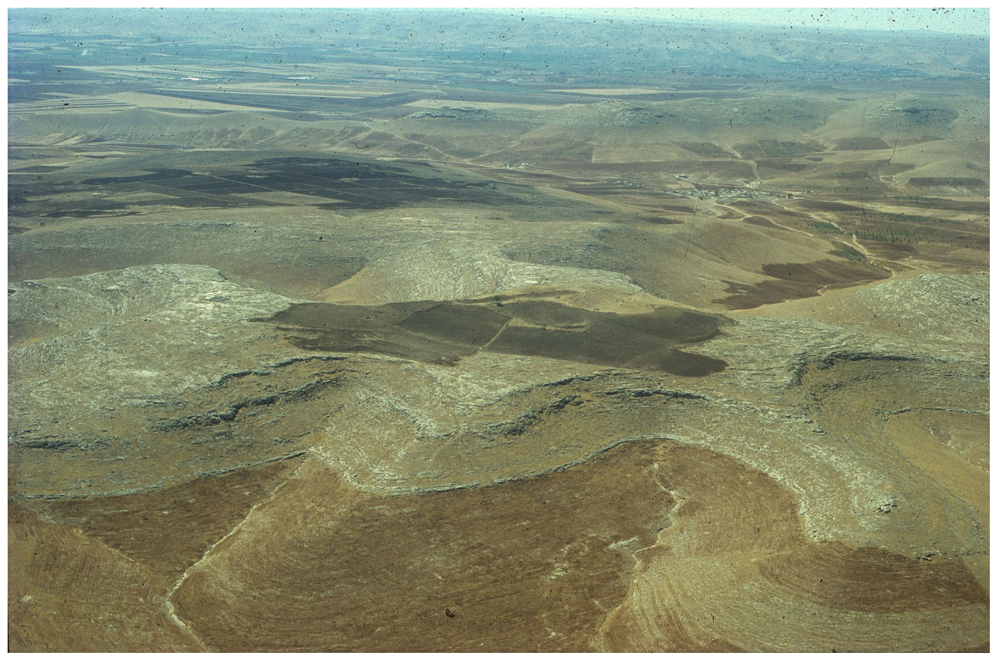
Figure 1. Aerial photo of Göbeklitepe (centre) and its surrounding landscape before the commencement of excavations in 1995. The prehistoric settlement is located on a limestone spur in the Germuş Mountains. This landscape is characteristic of the entire Taş Tepeler Project area. In the southwest, the Harran plain is visible towards the top of the picture, with the Fatik (Cudi) Mountains on the horizon. Author unknown, German Archaeological Institute, Göbeklitepe Project.
Heritage 09 00179 g001
Figure 3. Map showing the distribution of Epipalaeolithic and PPNA (Protoneolithic) sites in Mardin, Diyarbakır, Batman and Siirt provinces [137,138,139,140,141]. White dashed lines show the province borders. Sites with confirmed coordinates (black triangles): 1. Boncuklu Tarla, 2. Çayönü, 3. Hallan Çemi, 4. Demirköy, 5. Gusir Höyük, 6. Çemka Höyük, 7. Hasankeyf Höyük, 8. Körtiktepe, 9. Hindilla Mağarası, 10. Hindilla Yerleşimi, 11. Hazreti Ali Mağarları, 12. Tarin Mağarası, 13. Bahçebaşı Mağarası 1, 14. Bahçebaşı Mağarası 2, 15. Dara, 16. Hemini Mevki, 17. Kerike Mevki, 18. Hirbe Mamede Mevki, 19. Mazıdağı Kalesi Mevki, 20. Enginköy Mağarası, 21. Hirbe Serif Mevki, 22. Kün Aftare 1–5. Sites with estimated coordinates (red triangles): 1. Milane 1–3, 2. Hane Sore Höyük, 3. Amrud, 4. Dokane 1–8, 5. Kure 1–3, 6. İstasyon, 7. Çiftlik, 8. Güneşli, 9. Bikeyre 1, 10. Bikeyre 2, 11. Kuraman, 12. Bikeyre Höyük, 13. 12 Mart (Brehi), 14. Şika Rika 1–4, 15. Gundike Use, 16. Mer Babe 1–5. Image: B. Waszk, German Archaeological Institute.
Heritage 09 00179 g003
Figure 5. Map showing the distribution of PPNB sites in Mardin, Batman and Siirt provinces [137,138,139,140,141] (https://www.globalkites.fr). White dashed lines show the province borders. Sites with confirmed coordinates (black triangles): 1. Gre Filla, 2. Boncuklu Tarla, 3. Çayönü, 4. Gusir Höyük, 5. Serre Şippe Höyük, 6. Hindilla Mağarası, 7. Hazreti Ali Mağarları, 8. Bahçebaşı Mağarası 1, 9. Dara, 10. Enginköy Mağarası. Sites with estimated coordinates (red triangles): 1. Milane 1–3, 2. Hane Sore Höyük, 3. Amrud, 4. Dokane 1–8, 5. Kure 1–3, 6. İstasyon, 7. Çiftlik, 8. Güneşli, 9. Bikeyre 1, 10. Bikeyre 2, 11. Kuraman, 12. Bikeyre Höyük, 13. 12 Mart (Brehi), 14. Şika Rika 1–4, 15. Gundike Use, 16. Mer Babe 1–5. Image: B. Waszk, German Archaeological Institute.
Heritage 09 00179 g005
Figure 6. Map showing the distribution of PPNB sites in Şanlıurfa province [144,145,147,149] (https://www.globalkites.fr). 1. Ayanlar, 2. Gürcütepe, 3. Hamzantepe, 4. Harbetsuvan, 5. Karahantepe, 6. Kurttepesi, 7. Nevali Çori, 8. Sayburç, 9. Sefertepe, 10. Taşlı Tepe, 11. Yeni Mahalle, 12. Yoğunburç, 13. Mezraa Teleilat, 14. Akarçay Tepe, 15. Kısakuyu Höyüğü, 16. Hayrat Mevkii Çevresi, 17. Mağaralı Dere, 18. Eske Harebe II, 19. Sınır Tepesi Höyüğü, 20. Sumaklı Köyü—Sumaklı Besta Faki Mevkii, 21. Sumaklı Köyü—İsmail Kalesi, 22. İkiztepe Buluntu Alanı, 23. Sesigür/Zengulup, 24. Haleklitaş, 25. Doğanlar/Tekyamaç, 26. Göbekli, 27. Gotik Tepesi, 28. Cudi Zeytini, 29. İkiz Kuş Yamaç Yerleşmesi, 30. Erken Yamaç Yerleşmesi, 31. Tahta Harabesi Kesimhane/Kamp Yerleşme, 32. Hasmezra Yerleşmesi, 33. Nergislik Yamaç Yerleşmesi, 34. Eski Harabereler/Xrabeti Qewın, 35. Ebu Abit Tepesi, 36. İki Ağız, 37. Oluk Yanı, 38. Tül Harabesi, 39. Borbore, 40. Şebeke Harabeleri, 41. Sayburç Bademli Höyük. Image: B. Waszk, German Archaeological Institute.
Heritage 09 00179 g006
Figure 7. Göbeklitepe—Aerial view of a partially excavated cistern? (on-site) in trench K10-55 in 2015. Carved into the natural limestone bedrock, this feature has a diameter of 8.00 m and a maximum depth of 2.80 m. The edge of the pit features two to three courses of corbelled walling, constructed from large limestone slabs, held in place by smaller rocks (ballast). The feature is difficult to date, though its PPN age is confirmed stratigraphically. Image: N. Becker, German Archaeological Institute, Göbeklitepe Project.
Heritage 09 00179 g007
Figure 8. Göbeklitepe—The terrace wall on the northern slope above Special Building D during excavation in 2001 (top left, vertical) and 2002 (top right). Note the steps in the centre of the terrace wall, leading down to the area below. Possible slope slide damage in Special Building D under excavation in 2023 (bottom). Images: author unknown (top left), author unknown (top right), L. Clare (bottom), German Archaeological Institute, Göbeklitepe Project.
Heritage 09 00179 g008
Disclaimer/Publisher’s Note: The statements, opinions and data contained in all publications are solely those of the individual author(s) and contributor(s) and not of MDPI and/or the editor(s). MDPI and/or the editor(s) disclaim responsibility for any injury to people or property resulting from any ideas, methods, instructions or products referred to in the content.