From Drone-Based 3D Model to a Web-Based VR Solution Supporting Cultural Heritage Accessibility
Highlights
- The integration of close-range and UAV-based photogrammetry, mobile laser scanning (SLAM), and 360° panoramic images delivers high-resolution, multi-scale digital models of historic buildings in remote or difficult-to-access locations. This supports the precise documentation and analysis of built heritage.
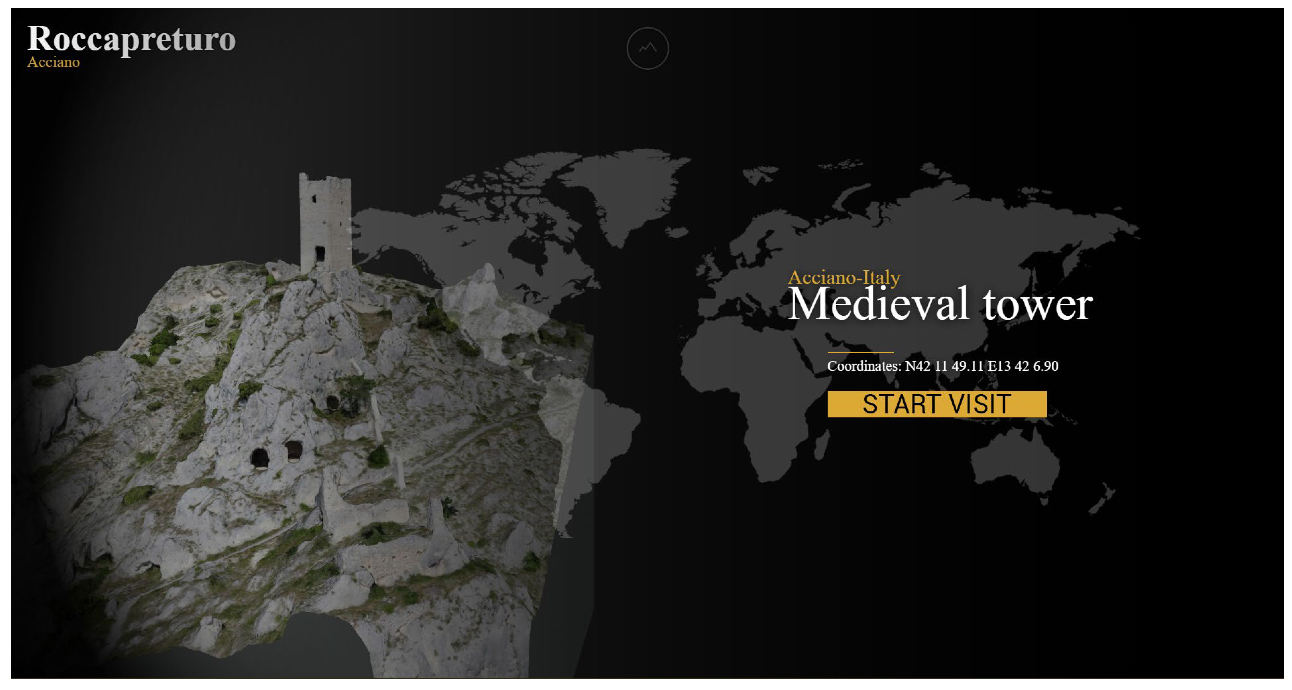
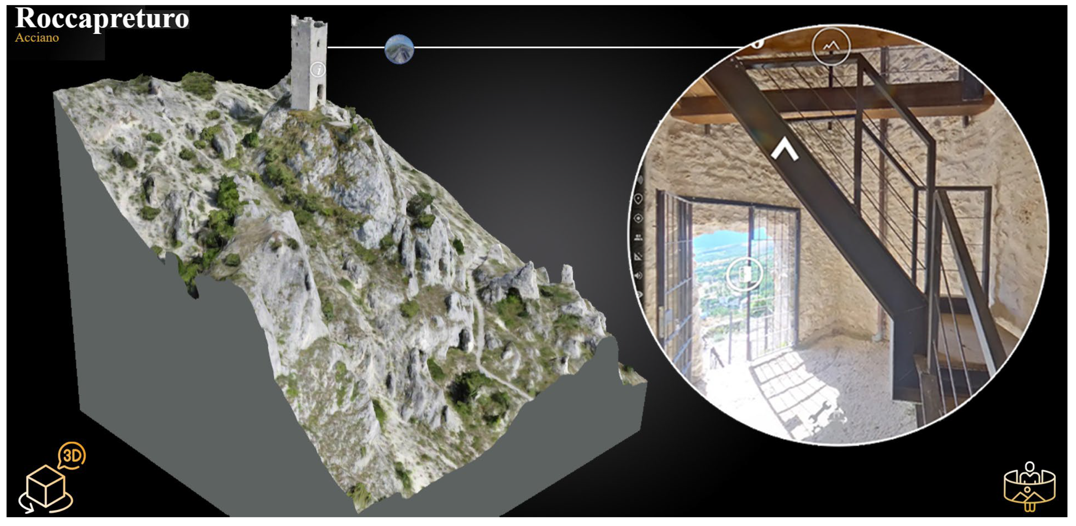
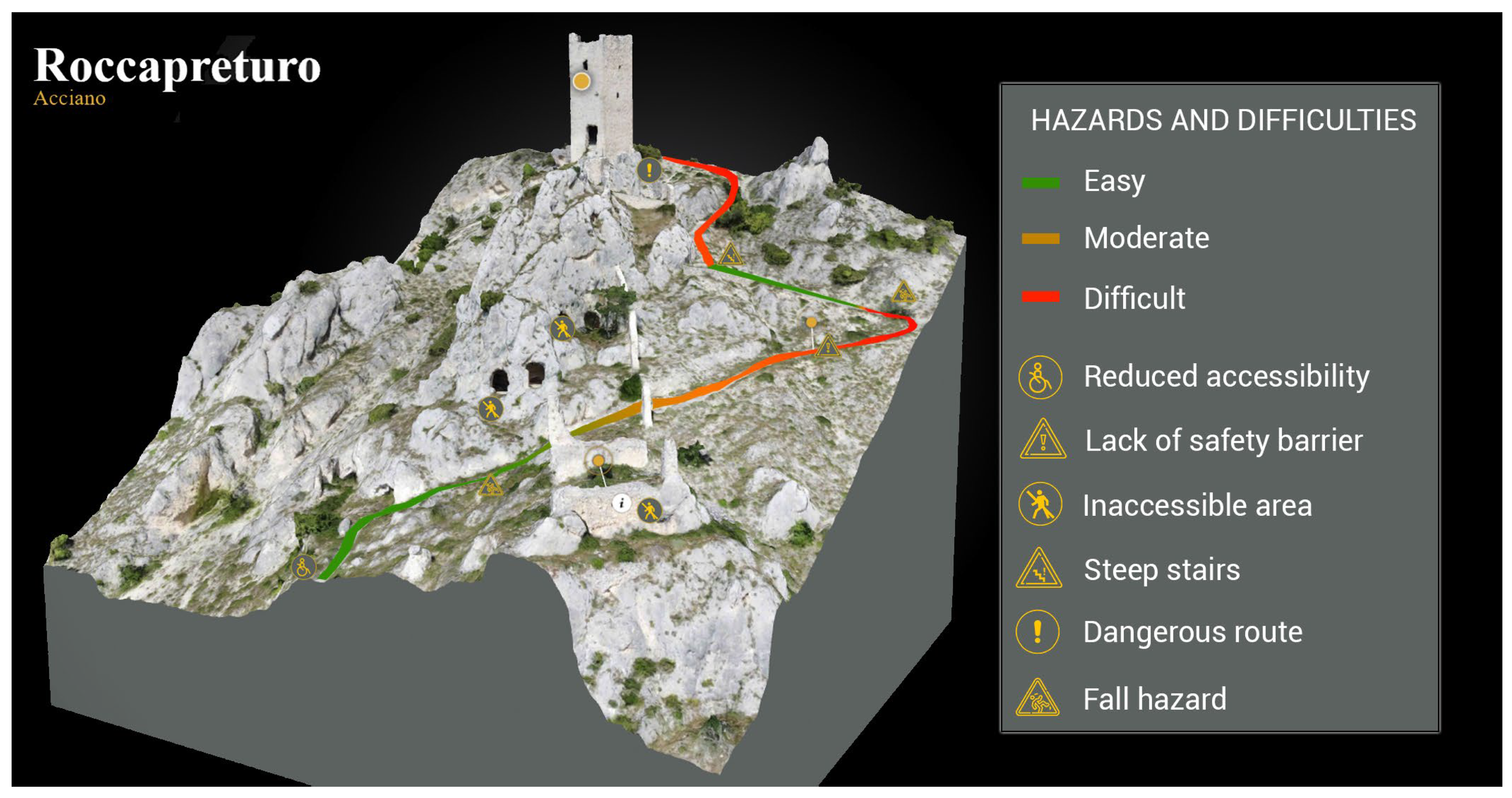
- A web-based VR platform has been developed to explore the Roccapreturo Tower, facilitating the visualization of complex architectural features and promoting safe and informed planning of on-site visits.
- The designed workflow is scalable and replicable for the digital preservation, documentation, and management of cultural heritage, in order to increase its accessibility to scholars, heritage administrators, and the general public.
- The integration of multi-sensor survey data into VR applications facilitates the dissemination of heritage, promotes sustainable and safe tourism in inner areas, and supports the development of informed conservation strategies.
Abstract
1. Introduction
2. Materials and Methods
The Digitalization of Architectural Heritage
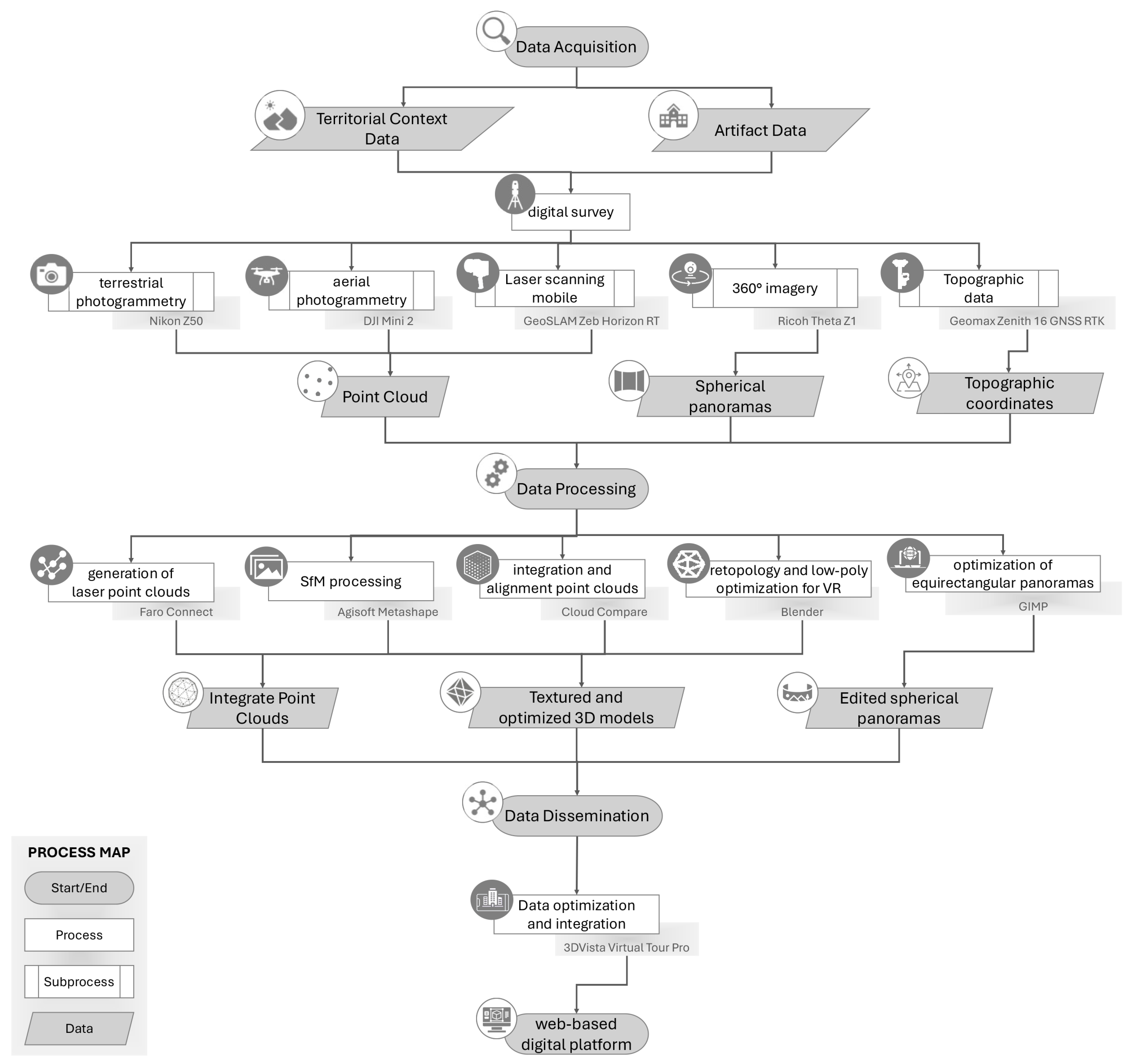
- UAV data collection for photogrammetric process, performed with a Mini 2 drone (DJI Sciences and Technologies Ltd., Shenzhen, China) equipped with a 12 MP 1/2.3” RGB CMOS sensor for the test;
- terrestrial close-range photogrammetry carried out using a Z50 camera, (Nikon Corporation, Tokyo, Japan) equipped with a 21.5 MP 1.8″ CMOS sensor;
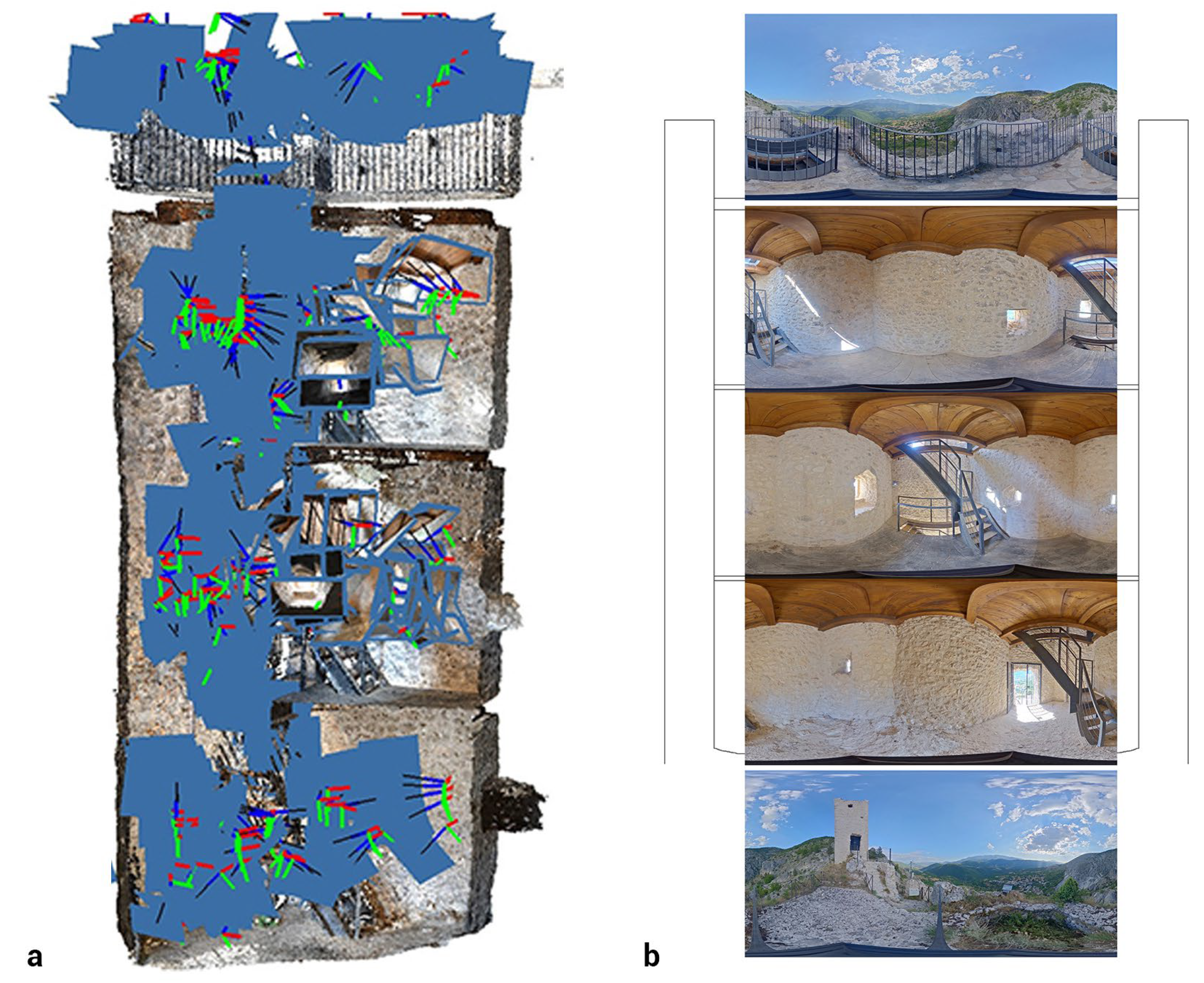
- capture of 360° panoramic imagery using a Theta Z1 camera (Ricoh Company Ltd., Tokyo, Japan) in the case described;
- acquisition of spatial data with a mobile laser scanner system, specifically, a GeoSLAM Zeb Horizon RT (FARO Technologies, Inc., Lake Mary, FL, America) using SLAM technology.
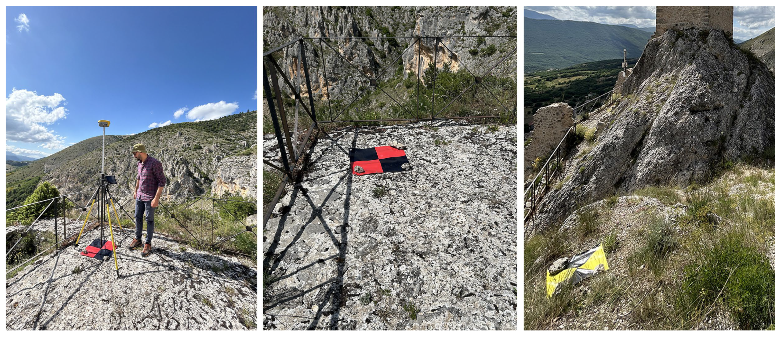
- Processing of Ground Control Points (GCPs) collected via GNSS for georeferencing and topographic alignment with the global coordinate system (WGS84 was used for the test). This facilitated the integration of point clouds obtained from both laser and aerial photogrammetric surveys. Specifically, Cloud Compare software was used for this purpose.
- Creation of the laser point clouds through dedicated algorithms. For the test, the algorithms integrated in the proprietary software Faro Connect (version 2024.1.3) were used.
- Construction of photogrammetric models using SfM algorithms. Specifically, Agisoft Metashape software (version 2.2.2.21287) was used following the dataset validation process, the alignment, the generation of dense point clouds, and integration with the GNSS data for both aerial and terrestrial surveys.
- Optimization of dense point clouds, generation of mesh geometries, and creation of textured models within the Agisoft Metashape.
- Retopology and optimization of the mesh to generate low-poly models suitable for Virtual Reality (VR) environments. In this specific case, the open-source platform Blender (version 4.1) was used.
- Editing and optimization of equirectangular panoramic images captured with the 360° camera, including brightness adjustments and quality assessment.
3. Results
3.1. The Integrated Survey
3.2. Digital Models: Processing and Optimization
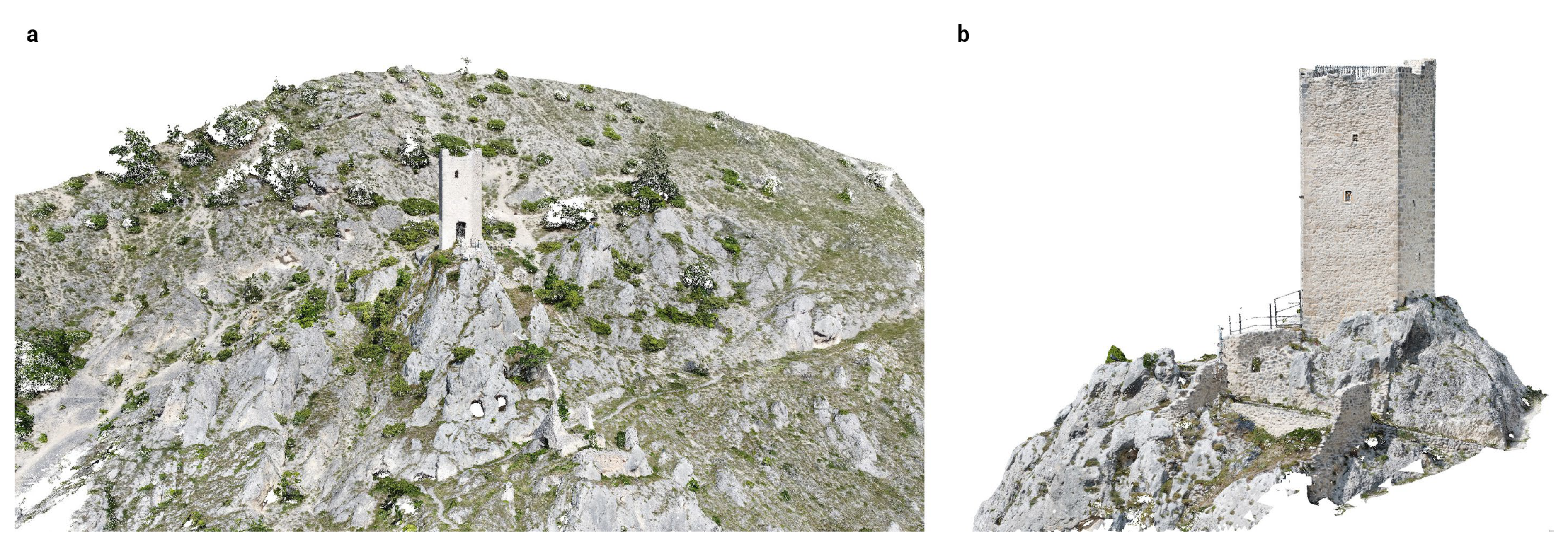
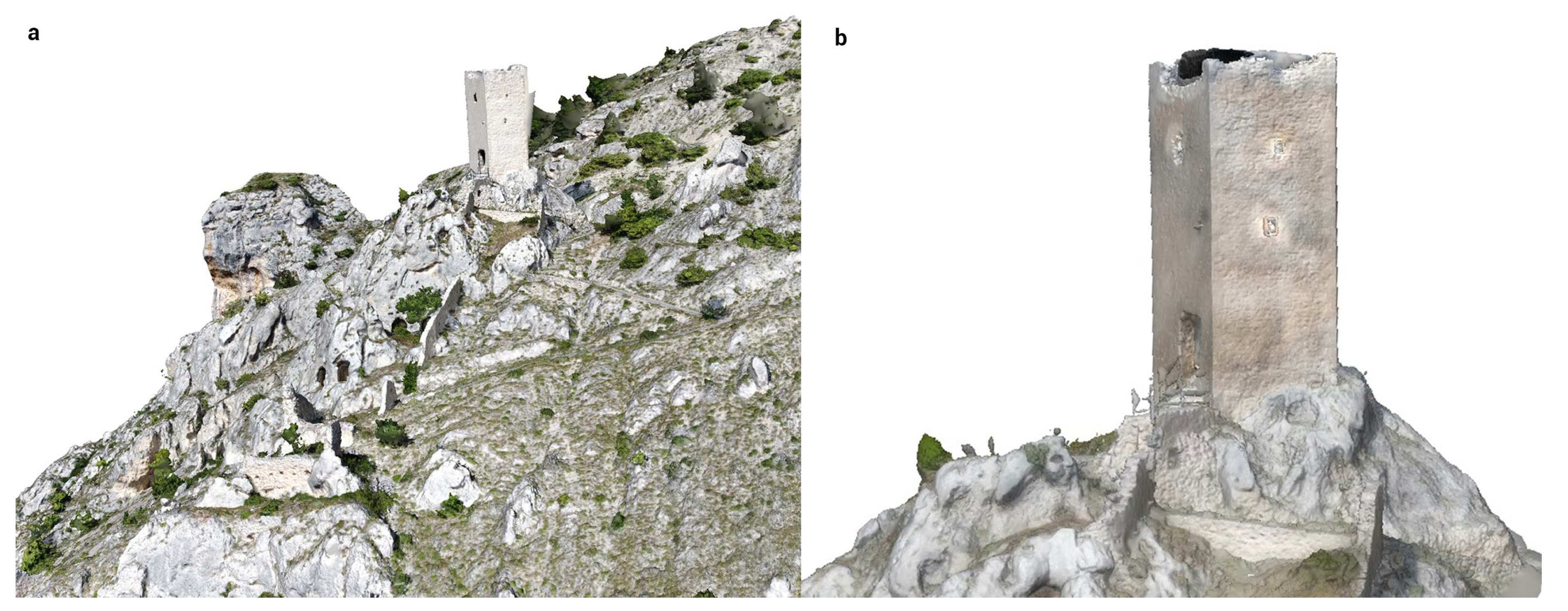
- a RGB dense cloud consisting of approximately 111 million points, derived from the UAV survey of the surrounding area (Figure 8a);
- a high-resolution dense cloud of about 233 million points, resulting from the integration of UAV and terrestrial datasets, providing a comprehensive representation of both the exterior and interior of the tower (Figure 8b).
3.3. VR Web-Based App for Virtual Replica Use
4. Discussion and Conclusions
Author Contributions
Funding
Data Availability Statement
Acknowledgments
Conflicts of Interest
References
- Barca, F.; Casavola, P.; Lucatelli, S. (Eds.) Strategia Nazionale per le Aree Interne: Definizione, Obiettivi, Strumenti e Governance; Materiali UVAL n. 31; Unità di Valutazione degli Investimenti Pubblici, Dipartimento per lo Sviluppo e la Coesione Economica: Roma, Italy, 2014. Available online: https://politichecoesione.governo.it/it/documenti-ed-esiti-istituzionali/documenti-del-nucleo/materiali-uval/documenti/numero-31-strategia-nazionale-per-le-aree-interne-definizione-obiettivi-strumenti-e-governance/ (accessed on 24 June 2025).
- Agenzia per la Coesione Territoriale. Strategia Nazionale Aree Interne (SNAI); Agenzia per la Coesione Territoriale: Roma, Italy, 2024. Available online: https://www.agenziacoesione.gov.it/strategia-nazionale-aree-interne/ (accessed on 24 June 2025).
- Atlante dei Piccoli Comuni. Available online: https://www.anci.it/atlante-dei-piccoli-comuni/ (accessed on 27 February 2025).
- Ministero dei beni e delle Attività Culturali. Linee Guida per la Valutazione e Riduzione del Rischio Sismico del Patrimonio Culturale Allineate alle Nuove Norme Tecniche per le Costruzioni (d.m. 14 Gennaio 2008). Circolare n. 26/2010. Available online: https://www.soprintendenzapdve.beniculturali.it/la-soprintendenza-informa/atti-di-indirizzo/linee-guida-per-la-valutazione-e-riduzione-del-rischio-sismico-del-patrimonio-culturale/ (accessed on 27 February 2025).
- Governo Italiano. Misure per il Sostegno e la Valorizzazione dei Piccoli Comuni, Nonché Disposizioni per la Riqualificazione e il Recupero dei Centri Storici (GU n.256 del 02-11-2017). Available online: https://www.normattiva.it/uri-res/N2Ls?urn:nir:stato:legge:2017;158 (accessed on 27 February 2025).
- Sargolini, M.; Pierantoni, I.; Polci, V.; Stimilli, F. (Eds.) Progetto Rinascita Centro Italia. Nuovi Sentieri di Sviluppo per l’Appennino Centrale Interessato dal Sisma del 2016; Carsa Edizioni: Pescara, Italy, 2022; Available online: https://www.carsaedizioni.it/progetto-rinascita-centro-italia/?v=05076a3091c6 (accessed on 12 September 2025).
- Istituto Nazionale di Statistica (ISTAT). Mappa dei Rischi dei Comuni Italiani: Cartografia; [Web GIS Portal]; ISTAT: Roma, Italy, 2023; Available online: https://gisportal.istat.it/mapparischi/index.html?extent= (accessed on 26 April 2023).
- Camera dei Deputati. Calamità Naturali [Temi Dell’attività Parlamentare]. Available online: https://temi.camera.it/leg19/temi/19_terremoti_d.html (accessed on 24 June 2025).
- Hernández, F.J.M.; González, V.B.; López, J.F.R.; Briz, X.M. A Methodological Approach to Rock Art Survey and Recording via Drone. The Application to the Rock Art of the Mediterranean Basin of the Iberian Peninsula Assemblage. Drone Syst. Appl. 2024, 12, 1–18. [Google Scholar] [CrossRef]
- Berquist, S.; Spence-Morrow, G.; Gonzalez-Macqueen, F.; Rizzuto, B.; Álvarez, W.Y.; Bautista, S.; Jennings, J. A New Aerial Photogrammetric Survey Method for Recording Inaccessible Rock Art. Digit. Appl. Archaeol. Cult. Herit. 2018, 8, 46–56. [Google Scholar] [CrossRef]
- Treccani, D.; Adami, A.; Fregonese, L. Drones and Real-Time Kinematic Base Station Integration for Documenting Inaccessible Ruins: A Case Study Approach. Drones 2024, 8, 268. [Google Scholar] [CrossRef]
- Gorgoglione, L.; Pierdicca, R.; Malinverni, E.S. Architetture complesse: Un rilievo integrato e multifunzionale per la mappatura completa del Palazzo dell’Emiro, Kogon (Uzbekistan). Boll. Soc. Ital. Fotogramm. Topogr. 2025, 2, 48–55. [Google Scholar]
- Scianna, A.; La Guardia, M. Survey and Photogrammetric Restitution of Monumental Complexes: Issues and Solutions—The Case of the Manfredonic Castle of Mussomeli. Heritage 2019, 2, 774–786. [Google Scholar] [CrossRef]
- Tan, Y.; Li, G.; Cai, R.; Ma, J.; Wang, M. Mapping and Modelling Defect Data from UAV Captured Images to BIM for Building External Wall Inspection. Autom. Constr. 2022, 139, 104284. [Google Scholar] [CrossRef]
- Pan, N.-H.; Tsai, C.-H.; Chen, K.-Y.; Sung, J. Enhancement of External Wall Decoration Material for the Building in Safety Inspection Method. J. Civ. Eng. Manag. 2020, 26, 216–226. [Google Scholar] [CrossRef]
- Freimuth, H.; König, M. Planning and Executing Construction Inspections with Unmanned Aerial Vehicles. Autom. Constr. 2018, 96, 540–553. [Google Scholar] [CrossRef]
- Ferreira, J.A.d.S.; Carrilho, F.R.L.; Alcantara, J.A.O.; Gonçalves, C.; Stolz, C.M.; Amario, M.; Haddad, A.N. Assessment of Staining Patterns in Facades Using an Unmanned Aerial Vehicle (UAV) and Infrared Thermography. Drones 2024, 8, 542. [Google Scholar] [CrossRef]
- Munawar, H.S.; Ullah, F.; Heravi, A.; Thaheem, M.J.; Maqsoom, A. Inspecting Buildings Using Drones and Computer Vision: A Machine Learning Approach to Detect Cracks and Damages. Drones 2022, 6, 5. [Google Scholar] [CrossRef]
- Fiorini, L.; Conti, A.; Pellis, E.; Bonora, V.; Masiero, A.; Tucci, G. Machine Learning-Based Monitoring for Planning Climate-Resilient Conservation of Built Heritage. Drones 2024, 8, 249. [Google Scholar] [CrossRef]
- García-Nieto, M.C.; Huesca-Tortosa, J.A.; Martínez-Segura, M.A.; de Gea, A.E.; Navarro, M. Structural Deformation Monitoring Using UAV Photogrammetry to Assess Slender Historic Buildings. J. Build. Eng. 2025, 100, 111766. [Google Scholar] [CrossRef]
- Fiorillo, F.; Perfetti, L.; Cardani, G. Automated Mapping of the Roof Damage in Historic Buildings in Seismic Areas with UAV Photogrammetry. Procedia Struct. Integr. 2023, 44, 1672–1679. [Google Scholar] [CrossRef]
- Russo, M.; Carnevali, L.; Russo, V.; Savastano, D.; Taddia, Y. Modeling and Deterioration Mapping of Façades in Historical Urban Context by Close-Range Ultra-Lightweight UAVs Photogrammetry. Int. J. Archit. Herit. 2019, 13, 549–568. [Google Scholar] [CrossRef]
- Fabris, M.; Achilli, V.; Menin, A.; Monego, M. Rilievo del Castello d’Illasi (Verona) mediante metodologie geomatiche integrate per l’analisi strutturale. In Atti della Conferenza ASITA 2022; Federazione ASITA: Genova, Italy, 2022; Available online: http://atti.asita.it/ASITA2022/Pdf/073.pdf (accessed on 25 June 2025).
- Lin, G.; Li, G.; Giordano, A.; Sang, K.; Stendardo, L.; Yang, X. Three-Dimensional Documentation and Reconversion of Architectural Heritage by UAV and HBIM: A Study of Santo Stefano Church in Italy. Drones 2024, 8, 250. [Google Scholar] [CrossRef]
- Di Stefano, F.; Torresani, A.; Farella, E.M.; Pierdicca, R.; Menna, F.; Remondino, F. 3D Surveying of Underground Built Heritage: Opportunities and Challenges of Mobile Technologies. Sustainability 2021, 13, 13289. [Google Scholar] [CrossRef]
- Dell’Amico, A. Mobile Laser Scanner Mapping System’s for the Efficiency of the Survey and Representation Processes. Int. Arch. Photogramm. Remote Sens. Spat. Inf. Sci. 2021, XLVI-M-1-2021, 199–205. [Google Scholar] [CrossRef]
- Balletti, C.; Breggion, E.; Gerla, F.; Guerra, F.; Martino, A. Venice: A Test Field for Urban Historical Centers Surveying with SLAM. In Proceedings of the 2024 IEEE International Workshop on Metrology for Living Environment (MetroLivEnv), Chania, Greece, 12–14 June 2024; pp. 224–229. [Google Scholar] [CrossRef]
- Kamburov, A.; Komatarova-Balinova, E.; Tsenov, M. Application of SLAM LiDAR Scanning for 3D Digitalization of the Murfatlar Rock Complex in Romania. In Proceedings of the 9th International Conference on Cartography and GIS, Nessebar, Bulgaria, 16–21 June 2024; Bandrova, T., Konečný, M., Marinova, S., Eds.; Bulgarian Cartographic Association: Sofia, Bulgaria, 2024; pp. 263–271. [Google Scholar]
- Sammartano, G.; Spanò, A. Point clouds by SLAM-based mobile mapping systems: Accuracy and geometric content validation in multisensor survey and stand-alone acquisition. Appl. Geomat. 2018, 10, 317–339. [Google Scholar] [CrossRef]
- Barba, S.; Ferreyra, C.; Cotella, V.A.; di Filippo, A.; Amalfitano, S. A SLAM Integrated Approach for Digital Heritage Documentation. In Culture and Computing. Interactive Cultural Heritage and Arts, HCII 2021. Lecture Notes in Computer Science; Rauterberg, M., Ed.; Springer: Cham, Switzerland, 2021; Volume 12794, pp. 27–39. [Google Scholar] [CrossRef]
- Pepe, M.; Alfio, V.S.; Costantino, D.; Herban, S. Rapid and Accurate Production of 3D Point Cloud via Latest-Generation Sensors in the Field of Cultural Heritage: A Comparison between SLAM and Spherical Videogrammetry. Heritage 2022, 5, 1910–1928. [Google Scholar] [CrossRef]
- Tanduo, B.; Teppati Losè, L.; Chiabrando, F. Documentation of complex environments in cultural heritage sites. A slam-based survey in the Castello del Valentino Basement. Int. Arch. Photogramm. Remote Sens. Spat. Inf. Sci. 2023, XLVIII-1/W1-2023, 489–496. [Google Scholar] [CrossRef]
- Sánchez-Aparicio, L.J.; Villanueva-Llauradó, P.; Sanz-Honrado, P.; Aira-Zunzunegui, J.R.; Pinilla Melo, J.; González-Aguilera, D.; Oliveira, D.V. Evaluation of a SLAM-Based Point Cloud for Deflection Analysis in Historic Timber Floors. Int. Arch. Photogramm. Remote Sens. Spat. Inf. Sci. 2023, XLVIII-M-2-2023, 1411–1418. [Google Scholar] [CrossRef]
- Marra, A.; Savini, F.; Giallonardo, M.; Fabbrocino, G.; Trizio, I. Multi-Sensors Acquisition for Digital Documentation. Application to a Damaged Area of Navelli Village. Disegnarecon 2022, 15, 4.1–4.15. [Google Scholar] [CrossRef]
- Roggero, M.; Diara, F. Multi-Sensor 3D Survey: Aerial and Terrestrial Data Fusion and 3D Modeling Applied to a Complex Historic Architecture at Risk. Drones 2024, 8, 162. [Google Scholar] [CrossRef]
- Rinaudo, F.; Scolamiero, V. Comparison of multi-source data, integrated survey for complex architecture documentation. Int. Arch. Photogramm. Remote Sens. Spat. Inf. Sci. 2021, XLVI-M-1-2021, 625–631. [Google Scholar] [CrossRef]
- Donato, E.; Giuffrida, D. Combined Methodologies for the Survey and Documentation of Historical Buildings: The Castle of Scalea (CS, Italy). Heritage 2019, 2, 2384–2397. [Google Scholar] [CrossRef]
- Calisi, D.; Botta, S.; Cannata, A. Integrated Surveying, from Laser Scanning to UAV Systems, for Detailed Documentation of Architectural and Archeological Heritage. Drones 2023, 7, 568. [Google Scholar] [CrossRef]
- Chudá, J.; Hunčaga, M.; Tuček, J.; Mokroš, M. The handheld mobile laser scanner as a tool for accurate positioning under forest canopy. Int. Arch. Photogramm. Remote Sens. Spat. Inf. Sci. 2020, XLIII-B1-2020, 211–218. [Google Scholar] [CrossRef]
- Hou, K.; Chio, S. Plane-based range calibration method for Geoslam Zeb-Horizon handheld lidar instrument. In Proceedings of the International Symposium on Remote Sensing (ISRS), Virtual, 26–28 May 2021. [Google Scholar]
- Elkhrachy, I. Accuracy Assessment of Low-Cost Unmanned Aerial Vehicle (UAV) Photogrammetry. Alex. Eng. J. 2021, 60, 5579–5590. [Google Scholar] [CrossRef]
- Agüera-Vega, F.; Carvajal-Ramírez, F.; Martínez-Carricondo, P. Assessment of photogrammetric mapping accuracy based on variation ground control points number using unmanned aerial vehicle. Measurement 2017, 98, 221–227. [Google Scholar] [CrossRef]
- Ellum, C.M.; El-Sheimy, N. New strategies for integrating photogrammetric and GNSS data. In Proceedings of the ISPRS Commission V Symposium “Image Engineering and Vision Metrology”, Dresden, Germany, 25–27 September 2006; Maas, H.-G., Schneider, D., Eds.; ISPRS Archives, Part 5. 2006; Volume XXXVI, pp. 103–108. Available online: https://www.isprs.org/proceedings/xxxvi/part5/ (accessed on 1 November 2025).
- Elamin, A.; Abdelaziz, N.; El-Rabbany, A. A GNSS/INS/LiDAR integration scheme for UAV-based navigation in GNSS-challenging environments. Sensors 2022, 22, 9908. [Google Scholar] [CrossRef]
- Lo, C.F.; Tsai, M.L.; Chiang, K.W.; Chu, C.H.; Tsai, G.J.; Cheng, C.K.; El-Sheimy, N.; Ayman, H. The direct georeferencing application and performance analysis of UAV helicopter in GCP-free area. Int. Arch. Photogramm. Remote Sens. Spat. Inf. Sci. 2015, XL-1/W4, 151–157. [Google Scholar] [CrossRef]
- Marra, A.; Trizio, I.; Savini, F. Multidisciplinary Approach for the Knowledge of Historical Built: Digital Tools for the Virtual Restoration. In Digital Restoration and Virtual Reconstructions; Trizio, I., Demetrescu, E., Ferdani, D., Eds.; Springer: Cham, Switzerland, 2023; pp. 205–224. [Google Scholar] [CrossRef]
- Marra, A.; Sandoli, A.; Trizio, I.; Fabbrocino, G.; Savini, F. Virtual Tour for Condition Assessment of Archaeological Sites. In Protection of Historical Constructions. PROHITECH 2025. Lecture Notes in Civil Engineering; Mazzolani, F.M., Landolfo, R., Faggiano, B., Eds.; Springer: Cham, Switzerland, 2025; pp. 36–43. [Google Scholar] [CrossRef]
- Savini, F.; Fabbrocino, G.; Marra, A. Digitization of historical architectural elements, a workflow for knowledge of minor centers in inner areas. Disegnarecon 2021, 14, 9.1–9.15. [Google Scholar] [CrossRef]
- UNI 11337-4:2017; Edilizia e Opere di Ingegneria Civile-Gestione Digitale dei Processi Informativi delle Costruzioni. Parte 4: Evoluzione e Sviluppo Informativo di Modelli, Elaborati e Oggetti. Ente Italiano di Normazione (UNI): Milano, Italy, 2017.
- Boje, C.; Guerriero, A.; Kubicki, S.; Rezgui, Y. Towards a semantic Construction Digital Twin: Directions for future research. Autom. Constr. 2020, 114, 103179. [Google Scholar] [CrossRef]
- Maiezza, P. As-Built reliability in architectural HBIM modeling. Int. Arch. Photogramm. Remote Sens. Spat. Inf. Sci. 2019, XLII-2/W9, 461–466. [Google Scholar] [CrossRef]
- Huang, W.; Gao, X.; Lu, J. Digital Construction Preservation Techniques of Endangered Heritage Architecture: A Detailed Reconstruction Process of the Dong Ethnicity Drum Tower (China). Drones 2024, 8, 502. [Google Scholar] [CrossRef]
- Banfi, F. BIM orientation: Grades of Generation and Information for different type of analysis and management process. Int. Arch. Photogramm. Remote Sens. Spat. Inf. Sci. 2017, XLII-2/W5, 57–64. [Google Scholar] [CrossRef]
- Theodoropoulos, A.; Antoniou, A. VR Games in Cultural Heritage: A Systematic Review of the Emerging Fields of Virtual Reality and Culture Games. Appl. Sci. 2022, 12, 8476. [Google Scholar] [CrossRef]
- Rodriguez-Garcia, B.; Guillen-Sanz, H.; Checa, D.; Bustillo, A. A systematic review of virtual 3D reconstructions of Cultural Heritage in immersive Virtual Reality. Multim. Tools Appl. 2024, 83, 89743–89793. [Google Scholar] [CrossRef]
- Checa, D.; Bustillo, A. A review of immersive virtual reality serious games to enhance learning and training. Multim. Tools Appl. 2020, 79, 5501–5527. [Google Scholar] [CrossRef]
- Chong, H.T.; Lim, C.K.; Rafi, A.; Tan, K.L.; Mokhtar, M. Comprehensive systematic review on virtual reality for cultural heritage practices: Coherent taxonomy and motivations. Multim. Syst. 2022, 28, 711–726. [Google Scholar] [CrossRef]
- Banfi, F.; Roascio, S.; Mandelli, A.; Stanga, C. Narrating Ancient Roman Heritage through Drawings and Digital Architectural Representation: From Historical Archives, UAV and LIDAR to Virtual-Visual Storytelling and HBIM Projects. Drones 2023, 7, 51. [Google Scholar] [CrossRef]
- Nguyen, T.B.T.; Le, T.B.N.; Chau, N.T. How VR Technological Features Prompt Tourists’ Visiting Intention: An Integrated Approach. Sustainability 2023, 15, 4765. [Google Scholar] [CrossRef]
- de Lurdes Calisto, M.; Sarkar, S. A Systematic Review of Virtual Reality in Tourism and Hospitality: The Known and the Paths to Follow. Int. J. Hosp. Manag. 2024, 116, 103623. [Google Scholar] [CrossRef]
- Tan, K.H.; Daman, D. A Review on Level of Detail. In Proceedings of the International Conference on Computer Graphics, Imaging and Visualization (CGIV 2004), Penang, Malaysia, 26–29 July 2004; pp. 70–75. [Google Scholar] [CrossRef]
- Ge, Y.; Xiao, X.; Guo, B.; Shao, Z.; Gong, J.; Li, D. A Novel LOD Rendering Method with Multilevel Structure-Keeping Mesh Simplification and Fast Texture Alignment for Realistic 3-D Models. IEEE Trans. Geosci. Remote Sens. 2024, 62, 1–19. [Google Scholar] [CrossRef]
- Tasdizen, T.; Whitaker, R.; Burchard, P.; Osher, S. Geometric Surface Processing via Normal Maps. ACM Trans. Graph. 2003, 22, 1012–1033. [Google Scholar] [CrossRef]
- Trizio, I.; Savini, F.; Marra, A.; Fabbrocino, G. Integrated Survey Procedures for Seismic Protection of Monumental Liturgical Furniture. J. Phys. Conf. Ser. 2022, 2204, 012067. [Google Scholar] [CrossRef]
- Di Paola, F.; Bombace, A.; Di Miceli, G.; Alogna, T. Reverse modelling process to support of a flemish wooden altarpiece physical restoration. Disegnarecon 2021, 14, 11.1–11.12. [Google Scholar] [CrossRef]
- Nguyen, D.V.; Hien, T.T.; Huong, T.T. A Subjective Quality Evaluation of 3D Mesh with Dynamic Level of Detail in Virtual Reality. In Proceedings of the 2024 IEEE International Conference on Image Processing (ICIP), Abu Dhabi, United Arab Emirates, 27–30 October 2024; pp. 1225–1231. [Google Scholar] [CrossRef]
- Ministero della Cultura. Piano Nazionale di Digitalizzazione del Patrimonio Culturale 2022–2023, Versione 1.1. Available online: https://digitallibrary.cultura.gov.it/wp-content/uploads/2023/04/PND_V1_1_2023_v2.pdf (accessed on 8 September 2025).
- M.A.C.IN.A. Multilevel Application for Cultural Information Archives. A Focus on the Inner Areas of Abruzzo and Sardinia Regions. [Institutional Website]. Italy. Available online: https://www.macina-prin.eu/ (accessed on 10 September 2025).
- DIHCUBE. Digital Italian Hub for Construction and Built Environment. [Institutional Website]. Italy. Available online: https://www.dihcube.eu/ (accessed on 10 September 2025).
- CTE. SICURA–Casa delle Tecnologie Emergenti (CTE) dell’Aquila. [Institutional Website]. Italy. Available online: https://www.ctesicuralaquila.it/ (accessed on 10 September 2025).
- Comune di Acciano. Roccapreturo. Available online: https://www.comune.acciano.aq.it/vivere-il-comune/luoghi/roccapreturo/ (accessed on 2 September 2025).
- Chiarizia, G.; Properzi, P. Abruzzo dei Castelli–Gli Insediamenti Fortificati Abruzzesi Dagli Italici all’Unità d’Italia; CARSA Editore: Pescara, Italy, 1995. [Google Scholar]
- Okanovic, V.; Ivkovic-Kihic, I.; Boskovic, D.; Mijatovic, B.; Prazina, I.; Skaljo, E.; Rizvic, S. Interaction in eXtended Reality Applications for Cultural Heritage. Appl. Sci. 2022, 12, 1241. [Google Scholar] [CrossRef]
- Melotti, M. The emergent role of edutainment in the fruition of cultural heritage. Form. Insegn. 2013, 11, 129–142. [Google Scholar] [CrossRef]






| Point ID | Latitude | Longitude | Ellipsoidal Height | RMS Horizontal | RMS Vertical |
|---|---|---|---|---|---|
| 100 | 42°11′49.6764″ | 13°42′07.8816″ | 916.949 m | 0.010 m | 0.010 m |
| 101 | 42°11′49.8608″ | E 13°42′07.7991″ | 915.798 m | 0.008 m | 0.014 m |
| 102 | 42°11′50.1148″ | E 13°42′07.6791″ | 915.952 m | 0.008 m | 0.012 m |
| 103 | 42°11′49.8480″ | E 13°42′07.0382″ | 916.987 m | 0.070 m | 0.013 m |
| 104 | 42°11′49.7653″ | E 13°42′07.1181″ | 917.877 m | 0.008 m | 0.016 m |
| 105 | 42°11′49.8692″ | E 13°42′07.0056″ | 916.976 m | 0.008 m | 0.017 m |
| 200 | 42°11′49.8338″ | E 13°42′07.0267″ | 916.991 m | 0.008 m | 0.019 m |
| 201 | 42°11′49.7770″ | E 13°42′07.1823″ | 917.963 m | 0.026 m | 0.041 m |
| 202 | 42°11′49.7104″ | E 13°42′07.0941″ | 916.604 m | 0.023 m | 0.040 m |
| 203 | 42°11′49.8502″ | E 13°42′07.0732″ | 917.019 m | 0.080 m | 0.020 m |
| 204 | 42°11′49.8576″ | E 13°42′07.1075″ | 917.067 m | 0.070 m | 0.018 m |
| 205 | 42°11′49.6227″ | E 13°42′07.3365″ | 914.600 m | 0.080 m | 0.020 m |
| 206 | 42°11′49.9311″ | E 13°42′07.7741″ | 915.617 m | 0.080 m | 0.021 m |
| 207 | 42°11′49.6860″ | E 13°42′07.8458″ | 916.795 m | 0.010 m | 0.023 m |
| Survey Technique | Equipment | Type of Data | Processed Output | Software |
|---|---|---|---|---|
| Aerial Photogrammetry (UAV) | DJI Mini 2 (12 MP CMOS sensor) | 720 photos | RGB dense point cloud: ~111 million points Mesh: ~37 million faces | Agisoft Metashape (version 2.2.2.21287) Cloud Compare (version 2.12.4) Blender (version 4.1) |
| Terrestrial Photogrammetry | Nikon Z50 (21.5 MP CMOS sensor) | 590 indoor and outdoor photos | RGB dense point cloud: ~233 million points Mesh: ~73 million faces | Agisoft Metashape (version 2.2.2.21287) Cloud Compare (version 2.12.4) Blender (version 4.1) |
Disclaimer/Publisher’s Note: The statements, opinions and data contained in all publications are solely those of the individual author(s) and contributor(s) and not of MDPI and/or the editor(s). MDPI and/or the editor(s) disclaim responsibility for any injury to people or property resulting from any ideas, methods, instructions or products referred to in the content. |
© 2025 by the authors. Licensee MDPI, Basel, Switzerland. This article is an open access article distributed under the terms and conditions of the Creative Commons Attribution (CC BY) license (https://creativecommons.org/licenses/by/4.0/).
Share and Cite
Savini, F.; Cordisco, A.; Fabbrocino, G.; Giallonardo, M.; Trizio, I.; Marra, A. From Drone-Based 3D Model to a Web-Based VR Solution Supporting Cultural Heritage Accessibility. Drones 2025, 9, 775. https://doi.org/10.3390/drones9110775
Savini F, Cordisco A, Fabbrocino G, Giallonardo M, Trizio I, Marra A. From Drone-Based 3D Model to a Web-Based VR Solution Supporting Cultural Heritage Accessibility. Drones. 2025; 9(11):775. https://doi.org/10.3390/drones9110775
Chicago/Turabian StyleSavini, Francesca, Alessio Cordisco, Giovanni Fabbrocino, Marco Giallonardo, Ilaria Trizio, and Adriana Marra. 2025. "From Drone-Based 3D Model to a Web-Based VR Solution Supporting Cultural Heritage Accessibility" Drones 9, no. 11: 775. https://doi.org/10.3390/drones9110775
APA StyleSavini, F., Cordisco, A., Fabbrocino, G., Giallonardo, M., Trizio, I., & Marra, A. (2025). From Drone-Based 3D Model to a Web-Based VR Solution Supporting Cultural Heritage Accessibility. Drones, 9(11), 775. https://doi.org/10.3390/drones9110775


