Abstract
When dealing with UAV path planning problems, evolutionary algorithms demonstrate strong flexibility and global search capabilities. However, as the number of UAVs increases, the scale of the path planning problem grows exponentially, leading to a significant rise in computational complexity. The Cooperative Co-Evolutionary Algorithm (CCEA) effectively addresses this issue through its divide-and-conquer strategy. Nonetheless, the CCEA needs to find a balance between computational efficiency and algorithmic performance while also resolving convergence difficulties arising from the increased number of decision variables. Moreover, the complex interrelationships between the decision variables of each UAV add to the challenge of selecting appropriate decision variables. To tackle this problem, we propose a novel collaborative algorithm called CCEA-ADVS. This algorithm reduces the difficulty of the problem by decomposing high-dimensional variables into sub-variables for collaborative optimization. To improve the efficiency of decision variable selection in the collaborative algorithm and to accelerate the convergence speed, an adaptive decision variable selection strategy is introduced. This strategy selects decision variables according to the order of solving single-UAV constraints and multi-UAV constraints, reducing the cost of the optimization objective. Furthermore, to improve computational efficiency, a two-stage evolutionary optimization process from coarse to fine is adopted. Specifically, the Adaptive Differential Evolution with Optional External Archive algorithm (JADE) is first used to optimize the waypoints of the UAVs to generate a basic path, and then, the Dubins algorithm is combined to optimize the trajectory, yielding the final flight path. The experimental results show that in four different scenarios involving 40 UAVs, the CCEA-ADVS algorithm significantly outperforms the Grey Wolf Optimizer (GWO), Particle Swarm Optimization (PSO), Artificial Bee Colony (ABC), and JADE algorithms in terms of path performance, running time, computational efficiency, and convergence speed. In addition, in large-scale experiments involving 500 UAVs, the algorithm also demonstrates good adaptability, stability, and scalability.
1. Introduction
As the technology of unmanned aerial vehicles (UAVs) matures, their application in fields such as military reconnaissance, disaster relief, and environmental monitoring is becoming increasingly widespread [1]. To achieve a higher level of autonomous flight, efficient multi-UAV path planning algorithms are essential. Multi-UAV path planning involves complex issues such as coordinating movements, avoiding obstacles, and optimizing paths for multiple UAVs. Through collaborative path planning, this approach can better meet the specific requirements of various missions, ensuring UAVs can safely and effectively adapt to changing environments and quickly generate new paths. More importantly, as the number of UAVs increases, the complexity of path planning also increases accordingly. Effective multi-UAV path planning algorithms can better adapt to the growing scale of UAV groups. In Table 1, we present a comprehensive overview of representative evolutionary algorithms. Additionally, these algorithms are summarized in terms of the algorithm’s authors, names, establishment times, and other aspects.
The UAV path planning problem is highly complex. Although researchers have proposed traditional heuristic methods such as mixed-integer linear programming [2,3,4], A* [5,6], RRT [7], and nonlinear programming [8], these methods have certain limitations when addressing this problem. They typically require discretization of the solution space and, in some cases, linearization of the model to simplify the problem. However, such processing leads to a lack of flexibility in these methods, making it difficult to deal with additional constraints or objectives. In contrast, metaheuristic algorithms demonstrate higher flexibility and effectiveness. These methods avoid the need to construct a time-consuming configuration space and can easily handle various constraints, such as threat areas, flight altitude restrictions, and turning radius requirements, as well as objectives. They also possess strong global search capabilities, which help to avoid falling into local optimal solutions. Current metaheuristic algorithms include Differential Evolution (DE) [9,10], Ant Colony Optimization (ACO) [11,12], Particle Swarm Optimization (PSO) [13,14,15], Genetic Algorithm (GA) [16,17], Artificial Bee Colony (ABC) [18], Firefly Algorithm (FA) [19,20], Grey Wolf Optimizer (GWO) [21,22], Artificial Potential Field (APF) [23], and Teaching–Learning-Based Optimization (TLBO) [24].
Table 1.
Related work on evolutionary algorithms.
Table 1.
Related work on evolutionary algorithms.
| Category | Author | Algorithm | Year |
|---|---|---|---|
| DE | Fu [25] | DE + QPSO | 2013 |
| Yu [26] | DE + GWO | 2013 | |
| Adhikari [27] | Adaptive Fuzzy DE algorithm | 2017 | |
| Ali [28] | DE + MMACO | 2023 | |
| RRT | Fathy S. Elkazzaz [29] | DE + RRT | 2017 |
| Farzad Kiani [30] | GWO + RRT | 2021 | |
| Fan Yang [31] | ACO + RRT | 2022 | |
| MF Aslan [32] | PSO + GDRRT* | 2023 | |
| CCEA | Wu [33] | CCEA | 2023 |
| Shao [34] | CCEA + DCPSO | 2019 | |
| Kesireddy [35] | CCEA + NSGA-II∖NSGA-III | 2019 | |
| Others | Fang [23] | APF | 2023 |
| Goel [19] | FA | 2018 | |
| Chen [11] | ACO + GA | 2021 | |
| Majumder [24] | MOTLBO | 2021 | |
| Shao [13] | PSO | 2020 |
The Differential Evolution (DE) algorithm, among other metaheuristic algorithms, has shown excellent performance in multi-UAV path planning. The DE algorithm guides the search through the differential vector between individuals, enabling it to escape local optima more effectively and enhance global search capabilities. Additionally, its mutation strategy helps maintain population diversity throughout the evolutionary process. In recent years, numerous researchers have attempted to address path planning problems using the DE algorithm and its variants. Fu et al. [25] proposed an algorithm that hybridizes DE with Quantum-Based Particle Swarm Optimization (QPSO), termed DEQPSO. Yu and Wang [26] proposed a Hybrid Group Search Optimizer (GSO) integrated with DE, utilizing Grey Wolf Optimization (GWO) to update flight paths through searching angles and distances, with DE employed to refine feasible UAV paths within the search area. Adhikari and Kim [27] proposed an Adaptive Fuzzy DE algorithm for UAV 3D path planning. In 2023, Ali et al. [28] proposed an innovative metaheuristic algorithm, a hybrid of Differential Evolution (DE) and Maximum–Minimum Ant Colony Optimization (MMACO). This new algorithm aims to improve upon the traditional DE algorithm by mitigating the blank areas that may arise during the optimization process of classical Ant Colony Optimization (ACO) and its enhanced version MMACO. Furthermore, the RRT algorithm has a distinct advantage in terms of solution speed due to its ability to quickly generate local optima. Many researchers have conducted studies on the RRT algorithm, resulting in numerous variants that integrate with metaheuristic algorithms. MF Aslan et al. [32] combined PSO with GDRRT* to propose a PSO-GDRRT* algorithm for rapidly finding the optimal path. Fan Yang et al. [31] addressed the local optimum issue of RRT by integrating Ant Colony Optimization with RRT, enabling the algorithm to achieve an ideal path plan. Farzad Kiani et al. [30] combined the RRT algorithm with three Grey Wolf Optimizers and their variants, leveraging the characteristics of RRT sampling and metaheuristic algorithms to identify the optimal path. F. S. Elkazzaz et al. [29] introduced a hybrid algorithm based on RRT* and Differential Evolution to solve the optimized path planning problem.
One notable characteristic of multi-UAV path planning is its high variable dimensionality. For instance, when dealing with 100 UAVs, if each UAV has 10 waypoints and each waypoint is represented by three variables, the total number of variables would reach 3000. To address this issue, an effective approach is to employ the Cooperative Co-Evolutionary Algorithm (CCEA). This algorithm effectively reduces the dimensionality of the problem by decomposing the complex problem into multiple sub-problems, making the search space more manageable and optimized. Moreover, the CCEA leverages parallel processing mechanisms to handle each sub-problem simultaneously, thereby significantly improving computational efficiency. Additionally, its unique co-evolutionary strategy balances local and global searches, not only enhancing the algorithm’s global optimization capability but also improving its ability to escape local optima. Consequently, many researchers have utilized the CCEA to solve path planning problems. For example, Shao et al. [34], building upon the foundation of co-evolution, proposed a Distributed Cooperative Particle Swarm Optimization (DCPSO) algorithm with an elitist preservation strategy. Kesireddy et al. [35] combined CCEAs with Non-Dominated Sorting Genetic Algorithm II (NSGA-II) and NSGA-III to address multi-objective problems for multiple agents. Wu et al. [33] proposed a multi-UAV collaborative path planning algorithm based on co-evolutionary optimization, designing two information sharing strategies to cope with the combined path search among multiple UAVs.
However, the application of the Cooperative Co-Evolutionary Algorithm (CCEA) for solving multi-UAV path planning still faces the following challenges: 1. The multi-UAV path planning problem is constrained by various conditions, and there is a complex interrelationship among the decision variables of each UAV, increasing the difficulty of selecting decision variables. 2. With the increase in the number of UAVs, the scale of the path planning problem grows exponentially, leading to a significant increase in computational complexity. In the practical application of multi-UAV path planning, it is necessary to enhance the computational speed of the algorithms on one hand, and on the other hand, to ensure that the algorithms can find effective flight routes. The CCEA needs to address the challenge of improving computational efficiency while maintaining the performance of the algorithm.
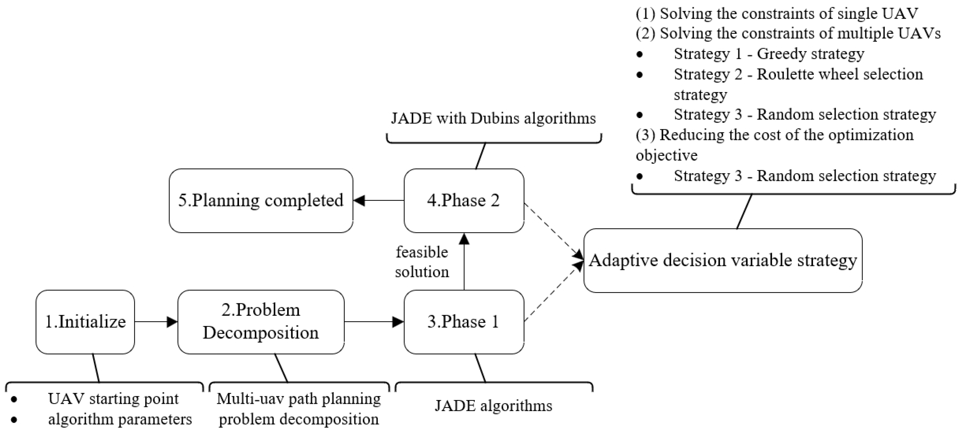
To address the first challenge, we propose an adaptive decision variable selection method guided by optimization objectives. This method fully leverages the collaborative information between UAVs to optimize the selection and execution of paths, enabling the algorithm to converge more rapidly to the optimal or near-optimal solution, thereby reducing computational time and the number of iterations. To tackle the second challenge, we propose a two-phase strategy. Initially, we plan a feasible solution for the path, and subsequently, based on this feasible solution, we refine the planning. This effectively reduces the number of evaluations the algorithm must perform and reduces the computational complexity of the algorithm. By integrating the advantages of the Cooperative Co-Evolutionary Algorithm (CCEA) and the Dubins path planning algorithm, we propose a Cooperative Co-Evolutionary Algorithm for UAV path planning problems, named CCEA-ADVS. Our contributions in this work are as follows:
- To enhance the efficiency of decision variable selection and to accelerate the convergence of the algorithm, an adaptive decision variable selection strategy is proposed. This strategy first addresses the single-UAV constraint problem, then the multi-UAV constraint problem, and finally, the path planning problem, adaptively selecting decision variables based on the current population state.
- To reduce the computational complexity and cost of the algorithm, a two-stage strategy is proposed. In the first stage, the algorithm generates a rough path for the UAV from the starting point to the destination. This path may not be optimal, but it provides a basic framework that can be refined in subsequent stages. The goal of the first stage is to quickly generate a feasible path rather than an optimal solution, thereby reducing computational load. The second stage involves Dubins path planning [36,37]. In this stage, the algorithm refines the path generated in the first stage by adjusting points and curves along the path, making the trajectory smoother and more precise, and meeting the actual flight requirements of the UAV. This kind of optimization usually requires more computational resources, but since a basic path is already in place, the optimization can be more targeted, thus reducing unnecessary computations. By adopting this coarse-to-fine approach, an effective balance between computational cost and path quality is achieved. A reasonable path is quickly generated in the first stage, and then, refined in the second stage, reducing the number of evaluations needed in the process of finding the optimal solution, thereby reducing the overall computational complexity.
- To demonstrate the advantages of the proposed algorithm, we conducted comparative experiments and algorithm analysis. We analyzed the encoding method, adaptive decision variable strategy, evolutionary algorithm, and two-stage strategy in the proposed algorithm, all of which showed good performance. Comparative experiments showed that the CCEA-ADVS algorithm significantly outperformed the GWO, PSO, ABC, and JADE algorithms in terms of path performance, running time, computational efficiency, and convergence speed. Moreover, in large-scale experiments involving 500 UAVs, the algorithm also demonstrated good adaptability, stability, and scalability.
The remainder of this paper is organized as follows: Section 2 designs the cost function for the multi-UAV path planning problem. Section 3 explains the basic principles of the CCEA and Dubins algorithms. Section 4 details the proposed CCEA-ADVS algorithm. Section 5 presents the comparative experiments with the algorithms, as well as an analysis of the algorithmic schemes. Finally, Section 6 and Section 7 are the discussion and conclusions, respectively.
2. Problem Description
Path planning for multiple UAVs is an extremely challenging problem, which not only requires consideration of the UAVs’ mission types, flight areas, and the UAVs’ own performance, but also the impact of obstacles on the path during flight and the issue of mutual collisions between UAVs. In this paper, we aim to develop an algorithm to generate a series of optimal or near-optimal flight paths from the starting point to the destination.
Assume the flight environment of the UAV is defined as E, the number of UAVs is M, and the velocity of each UAV is defined as . In this paper, we conduct planning at both the path point and trajectory levels. To evaluate the scores of the results, we need to discretize the path or trajectory into N points, where each point has the value of in the coordinate system. Then, the path of UAV m can be represented as , where represents the i-th waypoint of the m-th UAV. Our main objective is to find a set of paths that minimizes the total cost of all paths in the set.
To transform this problem into a global optimization problem, thereby increasing the likelihood of finding a global optimal solution or an approximate global optimal solution, we adopt the method of converting all constraints into a cost function. The cost function is configured in accordance with the references [38,39], Among them, path cost, threat cost, altitude cost, smoothing cost, and radar missile cost belong to the single-UAV constraint, and multi-UAV collision cost belongs to the multi-UAV constraint. Six cost constraints are set up as follows:
- Path cost: The path cost is calculated by summing the Euclidean distances between each waypoint and dividing by the Euclidean distance between the start and end points (minimum distance). The path cost for UAV m is calculated as follows:where represents the vector between two waypoints and , and are the coordinates of the i-th waypoint for the m-th UAV.
- Flight-prohibited zone cost: During actual flight, the path of the UAV must not overlap with the location of prohibited flight areas. The cost when the m-th UAV passes through obstacles can be expressed as follows:where Z is the total number of no-fly zones, and is the threat cost of the z-th no-fly zone to the path segment . The calculation method is as follows:where is the z-th no-fly zone. In this paper, two shapes of no-fly zones are considered: rectangular and circular.
- Altitude cost: In real life, UAVs often need to fly at low altitudes, so the impact of terrain on the safety of UAV flight must also be considered by adding altitude constraints. Let the minimum flight altitude of the UAV be , and the maximum flight altitude be . The flight altitude of the m-th UAV should be between the two, and the cost associated with the path and altitude is calculated as follows:where and are the maximum and minimum values of the altitude limit, respectively. The function represents the altitude at coordinates on the map.
- Smoothness cost: Smoothness constraints are an important indicator to evaluate whether the path generated by the UAV is feasible. UAVs have maximum angles when changing direction and climbing, so the limits of the UAV’s turning rate and climb rate must be considered when generating the path. The formulas for calculating the turning angle and climb angle of the m-th UAV are as follows:where and represent the projections of the path segments and on the xy plane, respectively.Thus, the smoothness cost can be expressed aswhere and are the cost functions for the turning angle and climb angle, respectively:
- Radar detection and missile kill cost: When planning UAV paths, the potential impact of combat platforms such as radar missiles on the UAV flight path must be considered. In this paper, the radars and missiles in different combat platforms are set to the same coordinates as the combat platform. The formula for calculating the distance between the path point and the l-th combat platform for the m-th UAV iswhere is the given position of the l-th combat platform, , and C is the number of combat platforms. Let the l-th radar have a radius of a circle. Then, the cost calculation formula between the UAV and the radar isIf the UAV is within the range of the enemy missile, it faces risks. A path with a lower kill risk is safer than one with a higher probability. For each path point, when the UAV is within the maximum risk distance area defined by the l-th enemy missile, it poses a certain kill risk to the UAV, represented asThe missile kill cost of the m-th UAV for the entire path is calculated as
- Multi-UAV collision cost: Assume that UAVs have a constant speed flight. To ensure safety, each point of the path of the u-th UAV is compared with every point of the v paths of the remaining UAVs. If the distance between two points is smaller than the safety threshold , the difference in their arrival times ( and ) is checked to see if it is less than the safe time interval to avoid collision risks. The arrival times and can be obtained by dividing the path by the speed. Thus, the total collision cost can be expressed as
- Total cost: The constrained costs for UAVs are transformed into cost functions, quantifying the quality of UAV paths by the total cost of the cost functions. The total cost function is shown as follows:where represents the weight coefficient of the i-th constraint or cost.
3. Preliminary Knowledge of CCEA-ADVS Algorithm
The heuristic co-evolutionary path planning method based on CCEA-ADVS employs the CCEA algorithm, JADE, and Dubins path planning to offer an efficient solution. By applying the co-evolutionary principle inherent to CCEA, the multi-UAV path planning problem is decomposed into individual sub-problems. JADE’s adaptive parameter adjustment is integrated to optimize and solve each. Using the preliminary paths from CCEA and JADE optimizations, the Dubins path planning method is then applied to generate UAV paths that are compatible with actual flight requirements.
3.1. Cooperative Co-Evolutionary Algorithm (CCEA)
CCEA, an optimization algorithm that employs co-evolutionary strategies [40,41], decomposes complex optimization problems into several sub-problems. These sub-problems are addressed through the co-evolution of multiple subpopulations within an evolutionary algorithm (EA) framework. The individual solutions are then integrated to form a comprehensive solution to the overarching problem.
The CCEA algorithm framework is presented in Algorithm 1. This framework applies local search and fitness sharing among individuals while ensuring adherence to constraint conditions to explore the solution space and escape local optima. In this context, EAStep (, b, ) represents the evolutionary algorithm function for generating and evaluating the offspring within subpopulations. SelectBest denotes the selection process for the next generation of parent subpopulations.
| Algorithm 1 Cooperative Co-Evolutionary Algorithm | |
| Require: The number of variables n, Subpopulation size . | |
| Ensure: Solution P | |
| 1: Problem decomposition, n-dimensional decision vector is divided into n 1-dimensional subcomponents {},{},…,{}. | |
| 2: Initialize the context vector . | ▹ is a solution for the i-th subpopulation. |
| 3: set | ▹ Evaluate the fitness |
| 4: for i← 1 to n do | |
| 5: Initialize the i-th subpopulation | ▹ |
| 6: for j ← 1 to do | |
| 7: | ▹ Evaluate each individual |
| 8: end for | |
| 9: end for | |
| 10: while stopping criterion is not met do | |
| 11: for i ← 1 to n do | |
| 12: , EAStep (, b, ) | ▹ generate and evalute offspring sub-populations |
| 13: the id of the best individual in | |
| 14: if then | |
| 15: | |
| 16: | |
| 17: end if | |
| 18: | |
| 19: end for | |
| 20: end while | |
| 21: function EAStep() | |
| 22: GeneticOperators | ▹ Generate offspring sub-population |
| 23: for j ← 1 to do | |
| 24: | |
| 25: end for | |
| 26: return , | |
| 27: end function | |
3.2. Dubins Algorithm
The Dubins path planning algorithm combines simple linear motions, including straight segments, left turns, and right turns, aiming to generate the shortest and most efficient path [36]. The core idea of this algorithm is to accurately determine the shortest path connecting two points in three-dimensional space while meeting the UAV’s curvature constraints and specific entry and exit directions. In essence, a Dubins path represents the shortest feasible path connecting two points in three-dimensional space with specific directions under a given maximum curvature constraint. This path typically consists of a sequence of CSC (circular arc–straight segment–circular arc) or CCC (three consecutive circular arcs) [37].
The Dubins algorithm’s advantage lies in its rigorous geometric principles, enabling the precise calculation of the shortest path within the physical constraints of flight and avoiding the computational errors and approximate solutions common to other algorithms. It offers a solution for UAVs that meets the physical constraints of flight while achieving the shortest flight distance.
4. Proposed Method
4.1. Algorithm Framework
In response to the issues with decision variable selection in the CCEA algorithm and the computational complexity of multi-UAV path planning, we propose the CCEA-ADVS algorithm. To reduce computational complexity and generate flight trajectories that meet practical requirements, the CCEA-ADVS algorithm employs a two-phase strategy. This approach transitions from coarse to fine, dividing the optimization into two phases. In the first phase, we conduct a rough search, using the JADE algorithm to quickly identify a feasible initial path solution. While this solution is not optimal, it serves as a solid foundation for the subsequent phase. In the second phase, we build on the initial path and conduct a more refined search. Applying the Dubins algorithm to refine the flight paths, we identify the optimal route that satisfies all constraints and closely aligns with the flight trajectories of UAVs in the real world. In order to improve the efficiency of decision variable selection in cooperative algorithms and accelerate the convergence of the algorithm, we introduce an adaptive decision variable selection strategy. The main process is shown in Figure 1.
Figure 1.
Main flow of CCEA-ADVS.
4.1.1. Individual Encoding Scheme
The choice of encoding is crucial for evolutionary algorithms, as it directly affects the efficiency of the algorithm, the representation of individuals, and the design of operations for the associated evolutionary algorithms.
In this paper, the encoding of an individual is represented by a list of 3D waypoints with a length of . During path planning, two waypoints are directly connected. In trajectory planning, two waypoints are connected using Dubins curves.
In existing evolutionary algorithms, these waypoints are typically represented in 3D coordinates using encoding methods such as Cartesian coordinate systems [13], polar coordinate systems [42], spherical vectors [43], and rotated Cartesian coordinate systems [39]. Among these, the rotated Cartesian coordinate system has shown better results and is simple to implement; therefore, we choose the rotated coordinate encoding method to encode the path solutions. For any waypoint , in a rotated coordinate system, its codification in the Cartesian coordinate system is mathematically defined as
where is the angle included by the direction from the start to the waypoint and -axis, and is the angle between the -axis and x-axis.
4.1.2. Multi-UAV Path Planning Problem Decomposition
When dealing with multi-UAV problems, the originally complex multi-UAV path planning problem is transformed into a series of more easily solvable single-UAV path planning problems, as shown in Figure 2. Assuming there are M UAVs, this results in decision variables. If the decision variable b is divided into M groups according to , then , where each contains decision variables . In this way, the path planning problem for each UAV can be carried out independently while ensuring that collision avoidance requirements between all UAVs are met within the overall mission. Although each UAV’s path planning problem only considers collision avoidance constraints directly related to that UAV, other global constraints, such as flight regulations and environmental limitations, still apply to the planning process of each UAV and remain unchanged. Let a single UAV be denoted as m. The collision cost for UAV m is as follows:
Figure 2.
Problem decomposition.
Then, the calculation of the sub-problem cost of UAV m becomes
4.1.3. CCEA-ADVS Algorithm
Algorithm 2 provides a detailed description of the specific steps of the CCEA-ADVS algorithm. It begins with problem decomposition and the initialization of the environmental vector b and the initial subpopulation (lines 1–6). It then proceeds with the decision variable selection strategy (line 8) and a two-phase optimization strategy. The decision variable selection is represented by the function DecisionVariableSelect, detailed in Algorithm 3. Here, Ord denotes the order set of decision variable selection, and I represents the set of decision variables that require updating. Subsequently, the decision variables (UAV paths) are updated according to the selection order. The first phase optimizes the flight path through the JADE algorithm (line 11), and the second phase refines the flight path through the Dubins algorithm (line 13), followed by an update of the environmental variables b and the selection of the next parent subpopulation (lines 15–22). Finally, the algorithm outputs a path planning solution that effectively selects decision variables during the planning process, improves the computational efficiency of the algorithm, and ensures the efficient and safe operation of the UAVs.
| Algorithm 2 CCEA-ADVS algorithm | |
| Require: Number of UAVs M, the number of waypoints , Subpopulation size . | |
| Ensure: Solution P | |
| 1: Problem decomposition, the decision vector is divided into M -dimensional subcomponents {,…,},…,{,…,}. | |
| 2: Initialize the context vector . | ▹ is a solution for the i-th subpopulation. |
| 3: Assign strategy weights . | |
| 4: set | ▹ Evaluate the fitness |
| 5: for i← 1 to M do | |
| 6: Initialize the i-th subpopulation | |
| 7: for j ← 1 to do | |
| 8: | |
| 9: end for | |
| 10: end for | |
| 11: for iter = 1 to do | |
| 12: | |
| 13: ,, | ▹ Algorithm 3 |
| 14: for i ← to do | |
| 15: if iter then | ▹ Maximum Number of Phase 1 Iterations |
| 16: , | ▹ Phase 1, Algorithm 4 |
| 17: else | |
| 18: , JADEWithDubins | ▹ Phase 2 |
| 19: end if | |
| 20: the id of the best individual in | |
| 21: if then | |
| 22: , | ▹ Update context vector |
| 23: end if | |
| 24: | |
| 25: end for | |
| 26: if then | |
| 27: | ▹ Update weights |
| 28: else | |
| 29: | ▹ Update weights |
| 30: end if | |
| 31: end for | |
| 32: | |
| 33: return P | |
4.2. Adaptive Decision Variable Selection Strategy
The selection of decision variables is a crucial step in multi-UAV path planning. Multi-UAV path planning in complex environments is inherently complex, further complicated by the need for UAV collaboration, requiring decision variables to balance individual UAV path optimization with overall collaborative objectives. In cooperative co-evolutionary path planning, most algorithms use a round robin or random method to select decision variables, which do not fully utilize the structural information of the problem and may lack specificity and optimization when selecting variables. To optimize the target-guided decision variable selection method, we proposes an adaptive decision variable selection strategy. The strategy first addresses single-UAV constraints, ensuring that the flight path of an individual UAV meets all basic flight constraints, such as avoiding obstacles, and complying with speed and altitude limits. Then, it addresses multi-UAV constraints, considering mutual constraints between multiple UAVs on the basis of single-UAV constraints, such as avoiding mutual collisions and coordinating flight paths. Finally, on the premise of meeting both single- and multi-UAV constraints, the path is further optimized to complete the path planning. The decision variable selection strategy is shown in Algorithm 3, with the following steps.
| Algorithm 3 Adaptive Decision Variables Selection Strategy | |
| Require: Number of UAVs M, context vector b, strategy weights | |
| Ensure: Decision variable set , Strategy weights , Selected Strategy | |
| 1: if constraints for single UAV are not met for b then | |
| 2: UAVs ids that do not meet the single-UAV constraints in b. | |
| 3: else | |
| 4: if exist Multi-UAV collision in b then | |
| 5: Randomly assign strategies according to weights . | |
| 6: else | |
| 7: | |
| 8: end if | |
| 9: | |
| 10: Count the number of collisions for each UAV | |
| 11: if =1 then | |
| 12: GreedyTopK | |
| 13: else if =2 then | |
| 14: Initializes decision variable set | |
| 15: VariableProbabilities | |
| 16: Randomly select different UAVs based on the . | |
| 17: else if = 3 then | |
| 18: Randperm | |
| 19: end if | |
| 20: end if | |
(1) Solving the constraints of a single UAV (lines 1–3): Each UAV or sub-problem can independently initiate with a solution, thereby taking turns. This solution ensures that each UAV has a feasible solution that is not infinite (a solution is considered feasible when the fitness costs of to are not infinite), and it also guarantees that each UAV or sub-problem has the opportunity to engage in the optimization process, establishing an initial reference point for subsequent cooperative evolution.
(2) Solving the constraints of multiple UAVs (lines 4–18): During the decision variable selection phase, autonomously select the appropriate decision variable selection strategy based on the operator weight . The following are the strategies for decision variable selection:
- Strategy 1 (greedy strategy): Optimizes the UAV with the most conflicts. The function GreedyTopK(K,) represents the greedy function, which returns the top UAVs with the most conflicts.
- Strategy 2 (roulette wheel selection strategy): The VariableProbabilities(K) function assigns selection probabilities based on the number of UAV conflicts, and the roulette wheel is used to select sub-problems according to the selection probabilities. This strategy combines randomness and conflict information, which helps to discover new optimization opportunities.
- Strategy 3 (random selection strategy): Represented by the Randperm(M,) function, it randomly selects sub-problems for decision variable selection. This strategy is simple and easy to implement but may lack specificity, leading to slow convergence and wasting a lot of computational resources.
(3) Reducing the cost of the optimization objective (lines 7 and 17): At this point, a feasible solution has been found, and variables can be selected in a completely random manner.
4.3. Adaptive Differential Evolution with Optional External Archive (JADE)
The JADE algorithm is an improved version of the Differential Evolution (DE) algorithm, automatically adjusting control parameters to enhance robustness. It uses historical data to inform evolutionary direction, effectively maintaining population diversity and improving convergence performance.
The JADE algorithm follows the basic steps of differential evolution, including initialization, mutation, crossover, selection, and adaptive parameter control, as shown in Algorithm 4. During mutation, new candidate solutions are generated using the ‘DE/current-to-pbest’ strategy. During crossover, individuals are produced using the crossover probability CR. During selection, the fittest individuals are selected based on fitness. Here, Normrnd() indicates that follows a normal distribution with mean and standard deviation 0.1, and Cauchyrnd() indicates that follows a Cauchy distribution with location parameter and scale parameter 0.1. Randint(1,3) randomly selects an integer between 1 and 3.
Additionally, within the CCEA framework, the JADE algorithm does not require convergence in a single call, thus a smaller number of iterations, , is employed. In this study, we set to 20.
| Algorithm 4 JADE algorithm framework | |
| Require: Subpopulation , context vector b, Subpopulation size . | |
| Ensure: Solution | |
| 1: set parameters , , Iterations | |
| 2: | ▹ represents current population of the first iteration |
| 3: for g← 1 to do | |
| 4: | |
| 5: for j← 1 to do | |
| 6: NormrndCauchyrnd, randint | |
| 7: Randomly choose as one of the 100% best vectors. | |
| 8: Randomly choose from . | |
| 9: Randomly choose from . | |
| 10: | |
| 11: for k ← 1 to 3 do | |
| 12: if or rand(0,1)< then | |
| 13: | |
| 14: else | |
| 15: | |
| 16: end if | |
| 17: end for | |
| 18: if then | |
| 19: | |
| 20: else | |
| 21: , , | |
| 22: end if | |
| 23: end for | |
| 24: Randomly remove solutions from A so that | |
| 25: , | |
| 26: end for | |
| 27: SelectBest | |
5. Experiment
5.1. Experiment Setup
This experiment is based on the simulation of real-world scenarios. The simulation experiments were conducted on a Lenovo laptop equipped with an Intel 2.5 GHz processor and 8 GB of RAM, according to the algorithm design. The experimental scenarios include four three-dimensional terrain maps generated from digital elevation model (DEM) data. We assume known position information for obstacles and combat platforms, which, with known center coordinates, radius, and height, are represented on the 3D maps. To thoroughly test the algorithm’s performance, the fourth scenario included 20 combat platforms and 7 no-fly zones, while the others included 5 combat platforms and 7 no-fly zones each. The four experimental scenarios are shown in Figure 3. We set the UAV speed, , to 100 km/h. The Dubins path’s turning radius is 3.8 km. The safety distance between the UAV and the edge of the threat is set to 15 km. The safety distance between UAVs is set to 10 km. The no-fly zones’ length and width are both set to 100 km. The radar radius is set to 50 km, and the missile radius is set to 15 km.
Figure 3.
Top view in four scenarios. Blue represents missile radar; gray is the no-fly zone. (a) Scenario 1. (b) Scenario 2. (c) Scenario 3. (d) Scenario 4.
In the absence of specific designations, the parameters related to the algorithms in this paper are shown in Table 2, with other parameters set according to Ref. [44].
Table 2.
CCEA-ADVS algorithm’s parameters.
5.2. Comparative Experiment with Existing Algorithms
5.2.1. Runtime and Quality
The comparative experiments of the algorithm were conducted with four algorithms—PSO [13,14,15], JADE [44,45], ABC [18], and GWO [21,22]—each compared across four scenarios, and all four methods used the priority planning method [46] to address UAV collision issues. The experimental setup in this section involved 40 UAVs, with each algorithm running 20 times and the results taken as the average. Table 3 lists the parameter settings for the comparative algorithms, which were configured according to the aforementioned references.
Table 3.
Parameter settings for the comparison algorithms.
Figure 4 illustrates the convergence curves of the five algorithms in four scenarios. It can be observed that the CCEA-ADVS algorithm demonstrates a faster convergence rate and the lowest cost consumption compared to the other four algorithms. Among them, the ABC algorithm performs the worst, with the slowest convergence speed and the poorest convergence precision. The ABC algorithm is greatly influenced by parameters and has high requirements for the continuity of the search space. When facing complex high-dimensional optimization problems, it takes a longer time to find better solutions and is prone to falling into local optima, with relatively weak global optimization capabilities. Although the GWO and PSO algorithms also have strong global search capabilities, their search processes rely more on guidance by the global optimum. In complex or high-dimensional search spaces, as the scale of UAVs and environmental complexity increase, this reliance leads to the algorithms being more likely to fall into local optima in later stages. The JADE algorithm, compared to GWO and PSO, has a slower convergence speed but results in lower cost consumption. The JADE algorithm, through its adaptive parameter control and “DE/current-to-pbest” mutation strategy, ensures the reliability of the algorithm while obtaining lower-cost paths, but this also leads to a relatively slower convergence rate of the algorithm.
Figure 4.
Convergence curves of the five algorithms. (a) Scenario 1. (b) Scenario 2. (c) Scenario 3. (d) Scenario 4.
Figure 5 shows a boxplot of the optimal costs of the five algorithms over 20 independent iterations in four scenarios, with statistical results presented in Table 4. It can be seen that the CCEA-ADVS algorithm performs very well in the four scenarios, obtaining the lowest path cost and consuming the least time compared to the other four algorithms. The smaller variance coefficient of the CCEA-ADVS algorithm proves its superiority in terms of stability. Less running time and lower path cost indicate that the algorithm’s planned path has higher performance in complex flight environments. In conjunction with the experiments in Section 5.3, the adaptive decision variable selection strategy adopted by the CCEA-ADVS algorithm improves the efficiency and cost effectiveness of path optimization, enabling the algorithm to obtain the lowest-cost flight path. The two-stage strategy greatly reduces the algorithm’s running time and computational complexity. In addition, the rotated coordinate encoding method adopted by the algorithm also has certain optimization effects on cost and running time. In summary, the CCEA-ADVS algorithm effectively enhances the computational efficiency and decision variable selection efficiency of the CCEA algorithm. The algorithm can more rapidly determine a flight path that is less costly and more secure and efficient.
Figure 5.
Box diagram of five algorithms run for 20 iterations. (a) Scenario 1. (b) Scenario 2. (c) Scenario 3. (d) Scenario 4.
Table 4.
The comparison results of the five algorithms in terms of cost and runtime. The best results achieved among all algorithms are shown in bold.
5.2.2. Scalability
When the number of UAVs reaches the level of hundreds, the comparative algorithms in the experiment (PSO, GWO, ABC, JADE) can no longer meet the path planning requirements. In order to test whether the CCEA-ADVS algorithm meets the requirements for large-scale UAV path planning, we compared the two situations: one without using the Dubins algorithm and the other with the Dubins algorithm. The first group of parameters was set to ; and the second group of parameters was set to , with all other parameters set according to Table 2.
The scalability and cost experimental results are depicted in Figure 6, with corresponding data detailed in Table 5. It can be seen from the figure that using Dubins planning (i.e., employing a two-phase strategy) yields a lower cost, and as the number of UAVs increases, the gap in cost widens. The time results for the algorithm are depicted in Figure 7, indicating that not using Dubins planning (i.e., conducting only the first-phase strategy) has a shorter running time, and thus, can obtain the UAV flight path more quickly compared to using only Dubins or employing a two-phase strategy. In summary, the CCEA-ADVS algorithm can meet the needs of large-scale UAV path planning and has excellent scalability. Furthermore, the scalability experiments demonstrate that the two-phase strategy combines the advantages of fast operation from the first phase and low path cost from the second phase, enabling the acquisition of an optimal path in a shorter amount of time.
Figure 6.
Fitness of the experiment.
Table 5.
Results of scalability analysis.
Figure 7.
Runtimes of the experiment.
5.2.3. Time Complexity Analysis
This section analyzes the time complexity of the proposed CCEA-ADVS algorithm. Assuming the complexity of calculating fitness is .
Firstly, the time complexity of the CCEA based on the JADE evolutionary algorithm is discussed. The basic steps of the algorithm are shown in Algorithm 1. The time complexity of each iteration of the algorithm = time complexity of initializing the population + time complexity of the co-evolutionary process. Time complexity for initializing the population: The time complexity for initializing the population of each sub-problem is . Time complexity of co-evolutionary process: . Thus, the total time complexity is . Since is much greater than 1, we can simplify this to .
In the CCEA-ADVS algorithm, the time complexity of the adaptive decision variable strategy is as shown in Algorithm 3, time complexity = solving the single-UAV constraint + solving the multi-UAV constraints + reducing the cost of the optimization objective time complexity. The time complexity is then . Since in the CCEA-ADVS algorithm, the execution times for solving the single-UAV constraints are much less than the latter two, we can simplify this to . The two-stage strategy is as shown in Algorithm 2. The time complexity of the CCEA-ADVS algorithm is . Since is much greater than M, it can be simplified to . Because , the proposed CCEA-ADVS algorithm enhances the convergence speed, making it more efficient.
5.3. Algorithm Analysis
5.3.1. Encoding Method Analysis
To validate that the rotated Cartesian vector (ROC) [39] encoding method is more suitable for the CCEA-ADVS algorithm to perform multi-UAV path planning, we compared it with the Cartesian (CAR) [13], relative polar (REP) [42], and relative spherical vector (RES) [43] encoding methods in four scenarios with 10 UAVs each.
The experimental results for the four coding methods are presented in Table 6. In terms of algorithmic cost, the rotated coordinate coding method consistently outperforms the other three, achieving the lowest cost and the shortest time consumption across all four scenarios. Among the methods evaluated, the Cartesian encoding approach exhibits the poorest performance. With an increasing number of UAVs, it incurs the highest costs and time consumption.
Table 6.
The results of different encoding methods are compared. The best results achieved among all algorithms are shown in bold.
In summary, the rotated coordinate coding method is superior to the other three, effectively reducing the errors associated with coordinate transformation and more naturally addressing the relative motion among multiple UAVs. By employing the rotated coordinate coding, a superior path can be obtained at a reduced cost and with minimized time expenditure.
5.3.2. Adaptive Decision Variable Strategy Analysis
To verify the superior performance of the proposed adaptive decision variable strategy, an analysis of the decision variable strategy is presented below. The strategy is compared with the greedy strategy (selecting only the UAV with the most conflicts with other UAVs) and the random selection strategy (randomly choosing UAVs in conflict). The comparative experiments were conducted in four scenarios, with each scenario run 20 times, and the results are taken as the average values.
The experimental results, as detailed in Table 7, indicate that the adaptive decision variable strategy results in the lowest cost compared to the greedy and random strategies. The random strategy exhibits the least favorable performance, characterized by the longest execution times and the highest cost expenditure. In comparison to the greedy strategy, the adaptive decision variable strategy more effectively evades local optima, leading to reduced cost consumption and expedited running times. The experiments confirm that the adaptive decision variable strategy enhances the efficiency and cost-effectiveness of path optimization, enabling the generation of more rapid and superior flight paths for UAVs.
Table 7.
Comparison experiment of three decision variable selection methods. The best results achieved among all algorithms are shown in bold.
5.3.3. Evolutionary Algorithm Analysis
To verify the effectiveness of the JADE evolutionary algorithm used in the path planning for multiple UAVs, this section conducts a comparative analysis of the performance of the JADE evolutionary algorithm. We compared JADE with PSO, GA, and DE using 10 UAVs across four scenarios, with each set of experiments conducted 20 times and the average values taken. The algorithm parameter settings can be found in Table 2.
The relevant experimental data of the evolutionary algorithms in the four scenarios are shown in Table 8. It can be observed that the JADE algorithm outperforms the other three algorithms, capable of obtaining flight paths with lower costs. Additionally, the time consumed by the algorithm is less than that of the PSO and GA algorithms, and slightly more than that of the DE algorithm. Therefore, selecting the JADE algorithm can yield a more optimal path that takes into account both cost and time.
Table 8.
The comparison results of the four algorithms in terms of cost and runtime. The best results achieved among all algorithms are shown in bold.
5.3.4. Two-Phase Strategy Analysis
To validate that the two-stage strategy can effectively reduce the computational complexity of the algorithm, this section conducts an experimental analysis of the strategy, exploring its performance. We deployed 10 UAVs across four scenarios, dividing the experiments into three groups: one conducting only the first stage of the algorithm (JADE), another conducting only the second stage (JADEWithDubins), and the third using the CCEA-ADVS algorithm. Each group was tested 20 times, and the results were averaged. The parameter settings for each group were as follows: the first group was set to . The second group was set to . The third group was set to . All other parameters were set according to Table 2.
The experimental results are presented in Table 9. The data indicate that the two-stage strategy employed by our algorithm exhibits superior performance across four different scenarios, incurring the lowest cost consumption. In terms of time efficiency, the two-stage strategy requires significantly less time compared to using only the Dubins path planning strategy, yet is slightly higher than the time taken by the strategy that executes only phase 1. Table 10 presents a comparative analysis of the rough path for phase 1 and the optimized Dubins path for phase 2 within the third group of UAVs, incorporating the scalability experiments detailed in Section 5.2.2. The two-stage strategy combines the fast running speed of phase 1 with the low path cost of phase 2, significantly reducing both running time and computational complexity. In conclusion, the two-stage strategy can achieve superior performance and expedited flight paths.
Table 9.
The comparison results of the two-stage strategies in terms of cost and runtime.
Table 10.
A comparative analysis of the paths of phase 1 and phase 2 for the third group ( = 50, = 50).
5.3.5. Visual Display of Planned Paths
In this paper, 10 UAVs were randomly selected for visual presentation. The algorithm’s planning results in a two-dimensional view are shown in Figure 8.
Figure 8.
Flight path planned by the proposed algorithm. Blue represents missile radar; gray is the no-fly zone. (a) Scenario 1. (b) Scenario 2. (c) Scenario 3. (d) Scenario 4.
It can be observed that by considering the airspace environment, flight conditions, and the UAVs’ own performance parameters, the algorithm can effectively reduce the risk of collisions with obstacles, radar and missile threats, and other UAVs, planning a flight path that is both safe and efficient. Furthermore, some UAVs cross the radar area due to the influence of their turning radii in Figure 8a,b,d. The algorithm significantly enhances both the safety and success rate of UAV missions, improves flight efficiency, and reduces unnecessary energy consumption and time costs. In summary, the algorithm demonstrates outstanding performance and practicality in multi-UAV path planning and is capable of conducting path planning in complex flight environments.
6. Discussion
This study provides innovative ideas for further improving the performance of the algorithm through an in-depth discussion of the decision variable subsets among CCEA collaborators, as well as a two-stage hierarchical optimization method. However, the obstacles and threats involved in the currently proposed methods are regular and static, which has certain limitations in practical applications. To more closely simulate real flight conditions and real-world flight environments, future work needs to be expanded in multiple areas. One area is the issue of obstacles and threats such as radar missiles with regular shapes. In reality, the shapes of obstacles are diverse, and threats like radar missiles are not just simple circles; everything still needs to be considered from various aspects based on actual conditions. Another area that needs to be explored is the algorithm’s adaptability to dynamic environments. In practical applications, the environment in which UAVs perform tasks is often dynamic, including sudden obstacles, weather changes, and dynamic threats such as weaponry. Static obstacles and threats often cannot meet actual needs. Enhancing the algorithm’s perception and adaptability to dynamic environments, enabling UAVs to adjust their path planning in a timely manner when the environment changes, is one of the key points of future research work.
In summary, although this study has made certain progress in the application of the CCEA algorithm, further exploration is still needed in the modeling of obstacles and threats in complex environments, as well as in the adaptability and response capabilities to dynamic environments. These research directions are crucial for promoting the comprehensive development of UAV technology, expanding its application prospects, and enhancing overall efficiency, and will lay a solid theoretical and technical foundation for the future application of the UAV field.
7. Conclusions
Addressing the large-scale three-dimensional UAV path planning problem, this paper proposes a CCEA-ADVS-based Cooperative Co-Evolutionary Algorithm. In the proposed method, the multi-UAV path planning problem is transformed into single-UAV path planning problems, and a cost function for individual UAVs is designed. Secondly, to enhance computational efficiency and reduce the scale of problem solving, a two-stage planning strategy is devised. This strategy progresses from coarse to fine, reducing the number of algorithmic evaluations in each phase by focusing on different optimization priorities, thereby increasing the operational speed and computational efficiency. For the conflict optimization of multiple UAVs, an adaptive decision variable selection strategy is proposed, which effectively combines environmental characteristics and UAV path planning features to improve path optimization efficiency and cost effectiveness. Finally, comparative experimental results show that the CCEA-ADVS algorithm outperforms other algorithms in both convergence accuracy and speed. In larger-scale experiments involving 500 UAVs, the proposed algorithm also demonstrates excellent processing capabilities and good scalability. The analysis of the algorithm indicates that the encoding method, evolutionary algorithm, and the adaptive decision variable strategy and two-stage strategy employed all offer better performance and higher efficiency. The CCEA-ADVS algorithm can effectively reduce the computational complexity of the algorithm, improve running speed, and plan safe, efficient, and low-cost flight paths.
Author Contributions
Conceptualization, Q.M., T.Y. and Q.Q.; methodology, Q.M., T.Y. and K.C.; software, Q.M., T.Y. and K.C.; formal analysis, Q.M. and Q.Q.; investigation, Q.M.; resources, Q.M. and Q.Q.; data curation, Q.M.; writing—original draft preparation, Q.M.; writing—review and editing, Q.M.; visualization, Q.M.; supervision, T.Y.; project administration, T.Y.; funding acquisition, Q.M. All authors have read and agreed to the published version of the manuscript.
Funding
This work is supported by the Hunan Provincial Department of Education Scientific Research Outstanding (22B0222).
Data Availability Statement
The data used to support this study have not been made available.
Conflicts of Interest
The authors declare no conflicts of interest.
References
- Qu, Q.; Meng, Q.; Chen, K.; Zhang, L. Research and Implementation of Ship/Unmanned Vehicle Collaborative Warfare Simulation System. In Proceedings of the 2023 IEEE 3rd International Conference on Data Science and Computer Application (ICDSCA), Dalian, China, 27–29 October 2023; pp. 275–279. [Google Scholar]
- Bellingham, J.S. Coordination and Control of UAV Fleets Using Mixed-Integer Linear Programming. Ph.D. Thesis, Massachusetts Institute of Technology, Cambridge, MA, USA, 2002. [Google Scholar]
- Kuwata, Y.; How, J. Three dimensional receding horizon control for UAVs. In Proceedings of the AIAA Guidance, Navigation, and Control Conference and Exhibit, Providence, RI, USA, 16–19 August 2004; p. 5144. [Google Scholar]
- Richards, A.; How, J.P. Aircraft trajectory planning with collision avoidance using mixed integer linear programming. In Proceedings of the 2002 American Control Conference (IEEE Cat. No. CH37301), Anchorage, AK, USA, 8–10 May 2002; Volume 3, pp. 1936–1941. [Google Scholar]
- Melchior, P.; Orsoni, B.; Lavialle, O.; Poty, A.; Oustaloup, A. Consideration of obstacle danger level in path planning using A* and fast-marching optimisation: Comparative study. Signal Process. 2003, 83, 2387–2396. [Google Scholar] [CrossRef]
- Szczerba, R.J.; Galkowski, P.; Glicktein, I.S.; Ternullo, N. Robust algorithm for real-time route planning. IEEE Trans. Aerosp. Electron. Syst. 2000, 36, 869–878. [Google Scholar] [CrossRef]
- Wang, W.; Deng, H.; Wu, X. Path planning of loaded pin-jointed bar mechanisms using Rapidly-exploring Random Tree method. Comput. Struct. 2018, 209, 65–73. [Google Scholar] [CrossRef]
- Raghunatan, A.; GV, S.D.; Biegler, L.; Samad, T. Dynamic Optimization Strategies for 3D Conflict Resolution of Multiple Aircraft. AIAA J. Guid. Control. Dyn. 2003, 27, 586–594. [Google Scholar] [CrossRef]
- Zhang, X.; Duan, H. An improved constrained differential evolution algorithm for unmanned aerial vehicle global route planning. Appl. Soft Comput. 2015, 26, 270–284. [Google Scholar] [CrossRef]
- Chakraborty, J.; Konar, A.; Jain, L.C.; Chakraborty, U.K. Cooperative multi-robot path planning using differential evolution. J. Intell. Fuzzy Syst. 2009, 20, 13–27. [Google Scholar] [CrossRef]
- Chen, Y.; Chen, M.; Chen, Z.; Cheng, L.; Yang, Y.; Li, H. Delivery path planning of heterogeneous robot system under road network constraints. Comput. Electr. Eng. 2021, 92, 107197. [Google Scholar] [CrossRef]
- Wu, H.; Li, H.; Xiao, R.; Liu, J. Modeling and simulation of dynamic ant colony’s labor division for task allocation of UAV swarm. Phys. A Stat. Mech. Its Appl. 2018, 491, 127–141. [Google Scholar] [CrossRef]
- Shao, S.; Peng, Y.; He, C.; Du, Y. Efficient path planning for UAV formation via comprehensively improved particle swarm optimization. ISA Trans. 2020, 97, 415–430. [Google Scholar] [CrossRef]
- Zhang, Y.; Gong, D.W.; Zhang, J.H. Robot path planning in uncertain environment using multi-objective particle swarm optimization. Neurocomputing 2013, 103, 172–185. [Google Scholar] [CrossRef]
- Qiaorong, Z.; Guochang, G. Path planning based on improved binary particle swarm optimization algorithm. In Proceedings of the 2008 IEEE Conference on Robotics, Automation and Mechatronics, Chengdu, China, 21–24 September 2008; pp. 462–466. [Google Scholar]
- Ye, F.; Chen, J.; Tian, Y.; Jiang, T. Cooperative multiple task assignment of heterogeneous UAVs using a modified genetic algorithm with multi-type-gene chromosome encoding strategy. J. Intell. Robot. Syst. 2020, 100, 615–627. [Google Scholar] [CrossRef]
- Shorakaei, H.; Vahdani, M.; Imani, B.; Gholami, A. Optimal cooperative path planning of unmanned aerial vehicles by a parallel genetic algorithm. Robotica 2016, 34, 823–836. [Google Scholar] [CrossRef]
- Xue, Y.; Jiang, J.; Zhao, B.; Ma, T. A self-adaptive artificial bee colony algorithm based on global best for global optimization. Soft Comput. 2018, 22, 2935–2952. [Google Scholar] [CrossRef]
- Goel, U.; Varshney, S.; Jain, A.; Maheshwari, S.; Shukla, A. Three dimensional path planning for UAVs in dynamic environment using glow-worm swarm optimization. Procedia Comput. Sci. 2018, 133, 230–239. [Google Scholar] [CrossRef]
- Aljarah, I.; Ludwig, S.A. A new clustering approach based on glowworm swarm optimization. In Proceedings of the 2013 IEEE Congress on Evolutionary Computation, Cancun, Mexico, 20–23 June 2013; pp. 2642–2649. [Google Scholar]
- Dewangan, R.K.; Saxena, P. Three-dimensional route planning for multiple unmanned aerial vehicles using Salp Swarm Algorithm. J. Exp. Theor. Artif. Intell. 2023, 35, 1059–1078. [Google Scholar] [CrossRef]
- Meidani, K.; Hemmasian, A.; Mirjalili, S.; Farimani, A.B. Adaptive grey wolf optimizer. Neural Comput. Appl. 2022, 34, 7711–7731. [Google Scholar] [CrossRef]
- Fang, Y.; Yao, Y.; Zhu, F.; Chen, K. Piecewise-potential-field-based path planning method for fixed-wing UAV formation. Sci. Rep. 2023, 13, 2234. [Google Scholar] [CrossRef]
- Majumder, A.; Majumder, A.; Bhaumik, R. Teaching–learning-based optimization algorithm for path planning and task allocation in multi-robot plant inspection system. Arab. J. Sci. Eng. 2021, 46, 8999–9021. [Google Scholar] [CrossRef]
- Fu, Y.; Ding, M.; Zhou, C.; Hu, H. Route Planning for Unmanned Aerial Vehicle (UAV) on the Sea Using Hybrid Differential Evolution and Quantum-Behaved Particle Swarm Optimization. IEEE Trans. Syst. Man Cybern. Syst. 2013, 43, 1451–1465. [Google Scholar] [CrossRef]
- Yu, C.; Wang, Z. UAV path planning using GSO-DE algorithm. In Proceedings of the 2013 IEEE International Conference of IEEE Region 10 (TENCON 2013), Xi’an, China, 22–25 October 2013; pp. 1–4. [Google Scholar] [CrossRef]
- Adhikari, D.; Kim, E.; Reza, H. A fuzzy adaptive differential evolution for multi-objective 3D UAV path optimization. In Proceedings of the 2017 IEEE Congress on Evolutionary Computation (CEC), Donostia, Spain, 5–8 June 2017; pp. 2258–2265. [Google Scholar] [CrossRef]
- Ali, Z.A.; Zhangang, H.; Zhengru, D. Path planning of multiple UAVs using MMACO and DE algorithm in dynamic environment. Meas. Control 2023, 56, 459–469. [Google Scholar] [CrossRef]
- Elkazzaz, F.S.; Abozied, M.A.; Hu, C. Hybrid RRT/DE Algorithm for High Performance UCAV Path Planning. In Proceedings of the 2017 VI International Conference on Network, Communication and Computing, Kunming, China, 8–10 December 2017; pp. 235–242. [Google Scholar]
- Kiani, F.; Seyyedabbasi, A.; Aliyev, R.; Gulle, M.U.; Basyildiz, H.; Shah, M.A. Adapted-RRT: Novel hybrid method to solve three-dimensional path planning problem using sampling and metaheuristic-based algorithms. Neural Comput. Appl. 2021, 33, 15569–15599. [Google Scholar] [CrossRef]
- Yang, F.; Fang, X.; Gao, F.; Zhou, X.; Li, H.; Jin, H.; Song, Y. Obstacle avoidance path planning for UAV based on improved RRT algorithm. Discret. Dyn. Nat. Soc. 2022, 2022, 4544499. [Google Scholar] [CrossRef]
- Aslan, M.F.; Durdu, A.; Sabanci, K. Goal distance-based UAV path planning approach, path optimization and learning-based path estimation: GDRRT*, PSO-GDRRT* and BiLSTM-PSO-GDRRT. Appl. Soft Comput. 2023, 137, 110156. [Google Scholar] [CrossRef]
- Wu, Y.; Nie, M.; Ma, X.; Guo, Y.; Liu, X. Co-Evolutionary Algorithm-Based Multi-Unmanned Aerial Vehicle Cooperative Path Planning. Drones 2023, 7, 606. [Google Scholar] [CrossRef]
- Shao, Z.; Yan, F.; Zhou, Z.; Zhu, X. Path Planning for Multi-UAV Formation Rendezvous Based on Distributed Cooperative Particle Swarm Optimization. Appl. Sci. 2019, 9, 2621. [Google Scholar] [CrossRef]
- Kesireddy, A.; Shan, W.; Xu, H. Global optimal path planning for multi-agent flocking: A multi-objective optimization approach with NSGA-III. In Proceedings of the 2019 IEEE Symposium Series on Computational Intelligence (SSCI), Xiamen, China, 6–9 December 2019; pp. 64–71. [Google Scholar]
- Dubins, L. On Curves of Minimal Length with a Constraint on Average Curvature, and with Prescribed Initial and Terminal Positions and Tangents. Am. J. Math. 1957, 79, 497–516. [Google Scholar] [CrossRef]
- Song, X.; Hu, S. 2D path planning with dubins-path-based A* algorithm for a fixed-wing UAV. In Proceedings of the 2017 3rd IEEE International Conference on Control Science And Systems Engineering (ICCSSE), Beijing, China, 17–19 August 2017; pp. 69–73. [Google Scholar]
- Besada-Portas, E.; de la Torre, L.; de la Cruz, J.M.; de Andrés-Toro, B. Evolutionary trajectory planner for multiple UAVs in realistic scenarios. IEEE Trans. Robot. 2010, 26, 619–634. [Google Scholar] [CrossRef]
- Yang, P.; Tang, K.; Lozano, J.A.; Cao, X. Path planning for single unmanned aerial vehicle by separately evolving waypoints. IEEE Trans. Robot. 2015, 31, 1130–1146. [Google Scholar] [CrossRef]
- Potter, M.A.; De Jong, K.A. A cooperative coevolutionary approach to function optimization. In International Conference on Parallel Problem Solving from Nature; Springer: Berlin/Heidelberg, Germany, 1994; pp. 249–257. [Google Scholar]
- Ma, X.; Li, X.; Zhang, Q.; Tang, K.; Liang, Z.; Xie, W.; Zhu, Z. A survey on cooperative co-evolutionary algorithms. IEEE Trans. Evol. Comput. 2018, 23, 421–441. [Google Scholar] [CrossRef]
- Yang, P.; Tang, K.; Lozano, J.A. Estimation of distribution algorithms based unmanned aerial vehicle path planner using a new coordinate system. In Proceedings of the 2014 IEEE Congress on Evolutionary Computation (CEC), Beijing, China, 6–11 July 2014; pp. 1469–1476. [Google Scholar]
- Phung, M.D.; Ha, Q.P. Safety-enhanced UAV path planning with spherical vector-based particle swarm optimization. Appl. Soft Comput. 2021, 107, 107376. [Google Scholar] [CrossRef]
- Pan, J.S.; Liu, N.; Chu, S.C. A hybrid differential evolution algorithm and its application in unmanned combat aerial vehicle path planning. IEEE Access 2020, 8, 17691–17712. [Google Scholar] [CrossRef]
- Zhang, H.H.; Wang, T.; Peng, X. Underwater glider 3D path planning with adaptive segments and optimal motion parameters based on improved JADE algorithm. Ocean Eng. 2024, 299, 117377. [Google Scholar]
- Li, H.; Long, T.; Xu, G.; Wang, Y. Coupling-Degree-Based Heuristic Prioritized Planning Method for UAV Swarm Path Generation. In Proceedings of the 2019 Chinese Automation Congress (CAC), Hangzhou, China, 22–24 November 2019. [Google Scholar]
Disclaimer/Publisher’s Note: The statements, opinions and data contained in all publications are solely those of the individual author(s) and contributor(s) and not of MDPI and/or the editor(s). MDPI and/or the editor(s) disclaim responsibility for any injury to people or property resulting from any ideas, methods, instructions or products referred to in the content. |
© 2024 by the authors. Licensee MDPI, Basel, Switzerland. This article is an open access article distributed under the terms and conditions of the Creative Commons Attribution (CC BY) license (https://creativecommons.org/licenses/by/4.0/).