1. Introduction
Drones are flying machines ranging from insect-sized flapping crafts to large airplanes the size of a commercial airline jet [
1]. Their capabilities are also wide-ranging: some drones are capable of flying for only a few minutes, while others can fly for days at a time. The applications of drones are also diverse. While the initial applications of drones were mainly for military purposes, and later for recreational purposes, drones are used today in many civil applications and in public spaces. Some of the most common commercial applications and uses for drones include agriculture (crop spraying, crop monitoring, etc.), live streaming events, emergency response, search and rescue, firefighting, disaster zone mapping, mapping and surveying, and artificial intelligence applications [
2,
3,
4,
5]. More recently, the societal utility of drones has been further enhanced in the management of the global COVID-19 pandemic, with use cases such as aerial spraying of public areas to disinfect streets, the surveillance of public spaces, and monitoring local authorities during lockdowns and quarantine [
6].
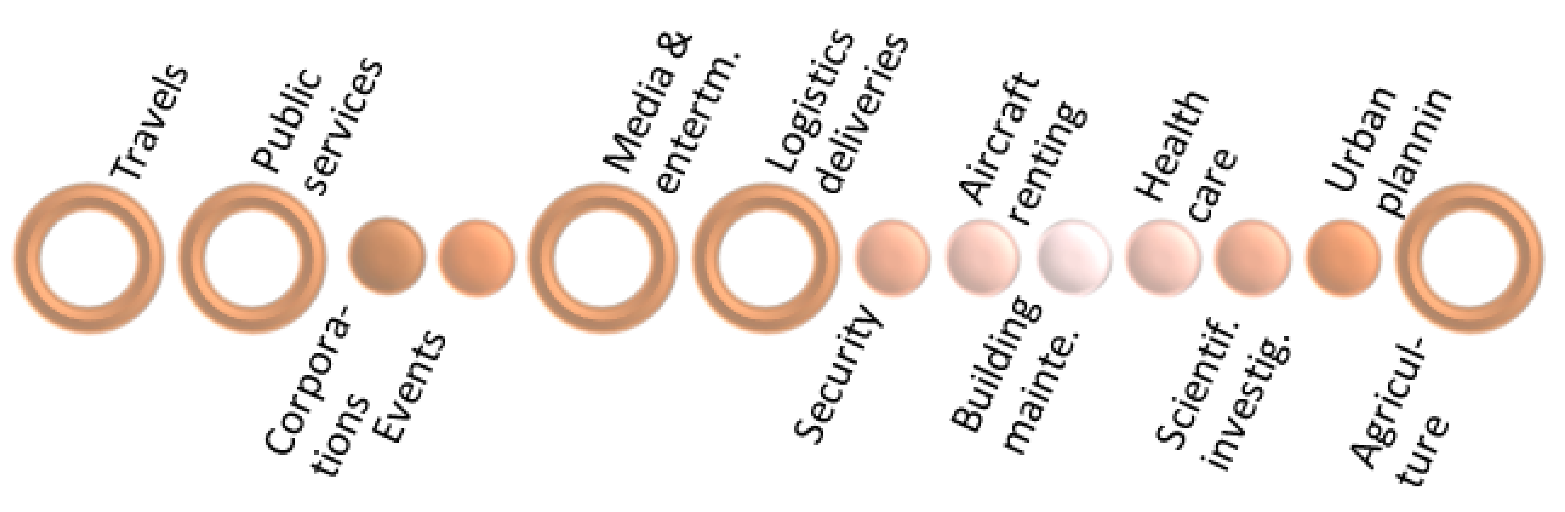
The 2016 European Drones Outlook Study [
7] forecasts a promising economical growth fostered by the emerging drone market. Unmanned aircraft will be part of everyday life in most of the economic sectors, as shown by the size of the bullets in
Figure 1, but will have a greater impact on air travel, utilities, entertainment and media, logistics, and agriculture. Indeed, the number of drones flying in the European airspace is expected to increase from a few thousand to several hundred thousand by 2050, most notably in government and commercial activities. The annual economic benefit could exceed EUR 10 billion by 2035 in Europe and create 100,000 new direct jobs to support drone-related operations. An example of this growth is illustrated by the agricultural sector, where authors estimate that 150,000 drones will be operated by 2035. The same is true in the fields of utilities and security, where around 60,000 unmanned aircraft will be used to assist in natural disaster management or traffic control, among other tasks.
However, despite the multiple operational services and the huge potential economic benefits of the drone industry, this relatively new technology will not really take off until the societal concerns associated with its widespread deployment are properly addressed.
As in the early days of aviation, safety will remain the main factor that will influence public acceptance of drones, especially as, unlike conventional commercial and general aviation, drones will often operate over moderately to densely populated areas and at lower altitudes. Visible to the naked eye, civil drone operations will raise questions about their nature and the risk they may represent for the populations and installations overflown. Noise pollution generated by drones will have to be contained to acceptable levels depending on the time of day and the frequency of operations. In addition, other societal and environmental impacts on the population, fauna, and flora will also have to be anticipated and mitigated.
Aware of these societal and environmental challenges, the CORUS-XUAM project has undertaken a review of surveys that covers the public acceptance of drones, and has initiated the identification of possible mitigation measures. The aim of this work is to address public concerns before the UAM business spread over cities, and have mitigation measures in place to facilitate a seamless acceptation of drones in our urban skies.
2. Public Surveys about Drones
The surveys reviewed are from various organizations (air traffic service providers, industry, research, universities, airspace security agencies) and countries (Australia, Germany, Brazil, USA, China, Korea, etc.), and were conducted between 2015 and 2021, 2018 being the inflection point in which drones were considered for the first time as new-entrant vehicles to share urban transport.
In 2015, Clothier et al. [
8] studied the risk perception and the public acceptance of drones in Australia. The objectives of this study were to investigate whether the public perceives the risks of drones differently to that of conventionally piloted aircraft, to provide guidance for setting safety requirements for drones, and to understand how the terminology used to describe the technology influences how the public perceives the risk. In this research, it was found that that terminology had a minimal effect on public perceptions. However, this may change as more information about the drone technology and risks and benefits of their usage becomes available to the public.
In 2016, the Office of Inspector General of the United States Postal Service published a report [
9] on the public perception of drone delivery in the United States. This report refers to an online survey that was administered, in June 2016, to a sample of 18–75-year-old residents in all 50 states and the District of Columbia to understand the current state of public opinion on drone delivery for potential customers. The survey showed, among other things, that most Americans like the concept of drone delivery rather than dislike it, but that many have yet to make up their minds. Different groups have different levels of interest in drone delivery. Drone malfunctions was the main concern of the public, but other concerns included misuse, privacy, potential damage, and nuisance.
In 2017, Lidynia et al. [
10] conducted a survey of 200 people, laypersons, and active users living in Germany about their acceptance and perceived barriers for drones. The survey questions were about the general evaluation of civil drone technology, barriers, demography, and further user factors. The survey results show that user diversity strongly influences the acceptance of drones and perceived barriers. Active drone pilots were more concerned by a risk of possible accidents, while laypeople were more concerned about the violation of their privacy (the routes that drones should and should not be allowed to use).
In 2018, an online survey from NATS [
11], the UK airspace service provider, showed that drone acceptance can range from
when seen as a generic technology tool, but raises to
when they are used in emergency situations. A deep market study conducted by NASA [
12] forecasts that, in the coming years, there will be numerous markets in which the drones will have a stake.
As a novelty, additional operations, such as passenger transport by unmanned aircraft, or “air taxis”, are expected to grow exponentially. Air taxis operations will reduce the travel times of part of the commuting traffic to city centers and contribute to decongesting ground transport by up to 25%. Urban air mobility (UAM) is emerging as the new concept for drones future business. In the US, the concept will later be extended to also include manned electrical vehicles with vertical take-off and landing capabilities, known as eVTOL, under the new term advanced air mobility (AAM). The paper shows that the acceptance level raises to 55% with the development of new safety technologies, the improvement in air flow network, and automation of the flights.
In 2019, Airbus conducted also a survey [
13] about the public perception of UAM. The Airbus survey covered four cities/countries around the world, Los Angeles, Mexico City, New Zealand, and Switzerland, and collected 1540 responses. Results revealed that 44.5% of respondents supported or strongly supported UAM and that 41.4% of respondents thought UAM was safe to very safe. This suggests that the initial perception of UAM is quite positive.
The same year, a meta-analysis from Legere of former US public surveys [
14] and the DLR survey to 832 German citizens [
15] showed acceptance levels of 60% and 49%, respectively. The meta-analysis focused on the different acceptance levels per mission, with public missions having higher acceptance than private/commercial uses. The German survey provides results about major public concerns. The most important one was the misuse of drones for crime (91%) and the violation of privacy (86%). Both surveys refer to generic (small) drones involved in missions such as police surveillance or search and rescue.
In 2020, Tan et al. [
16] surveyed the opinion of more than 1000 citizens from Singapore. Delivery drones and passenger vehicles were considered to have an average acceptance of 62%.
In 2021, an EASA survey [
17] obtained the highest acceptance (83%) for the UAM composed of passenger electrical vehicles, not necessarily unmanned, cargo drones, and also surveillance drones. Special emphasis was given to the different types of passenger vehicles, and also to concerns related to the environment.
In addition, surveys [
18,
19,
20] had a main focus on the analysis of the demand of the future UAM services. Questions were addressed to the public as potential customers. Kloss and Riedel surveyed almost 5000 people from Brazil, China, Germany, India, Poland, and the US. Acceptance was measured for different missions (six using eVTOL and four using cargo-drones) and they found out that only 27.3% of the people declared themselves willing to try passenger drones, mostly for commuting, business trips, or travels to/from airport). On the contrary, the willingness to use cargo drones, paying twice or more of today’s cost, was 57.8%.
More positive were the responses from the Lundqvist survey. This survey was conducted on almost 500 people from five EU regions (in Holland, England, Spain, Croatia, and Poland). Respondents were mainly connected to drone operators or their business. The general positive attitude towards drones was up to approximately 70%. Specific questions about concerns included safety, environment, and privacy issues. Finally, the Park and Joo survey was conducted in South Korea on more than 1000 citizens plus 44 experts. The willingness to use UAM (both passenger and cargo) was 47%, and decreased as the automation of the vehicles increased.
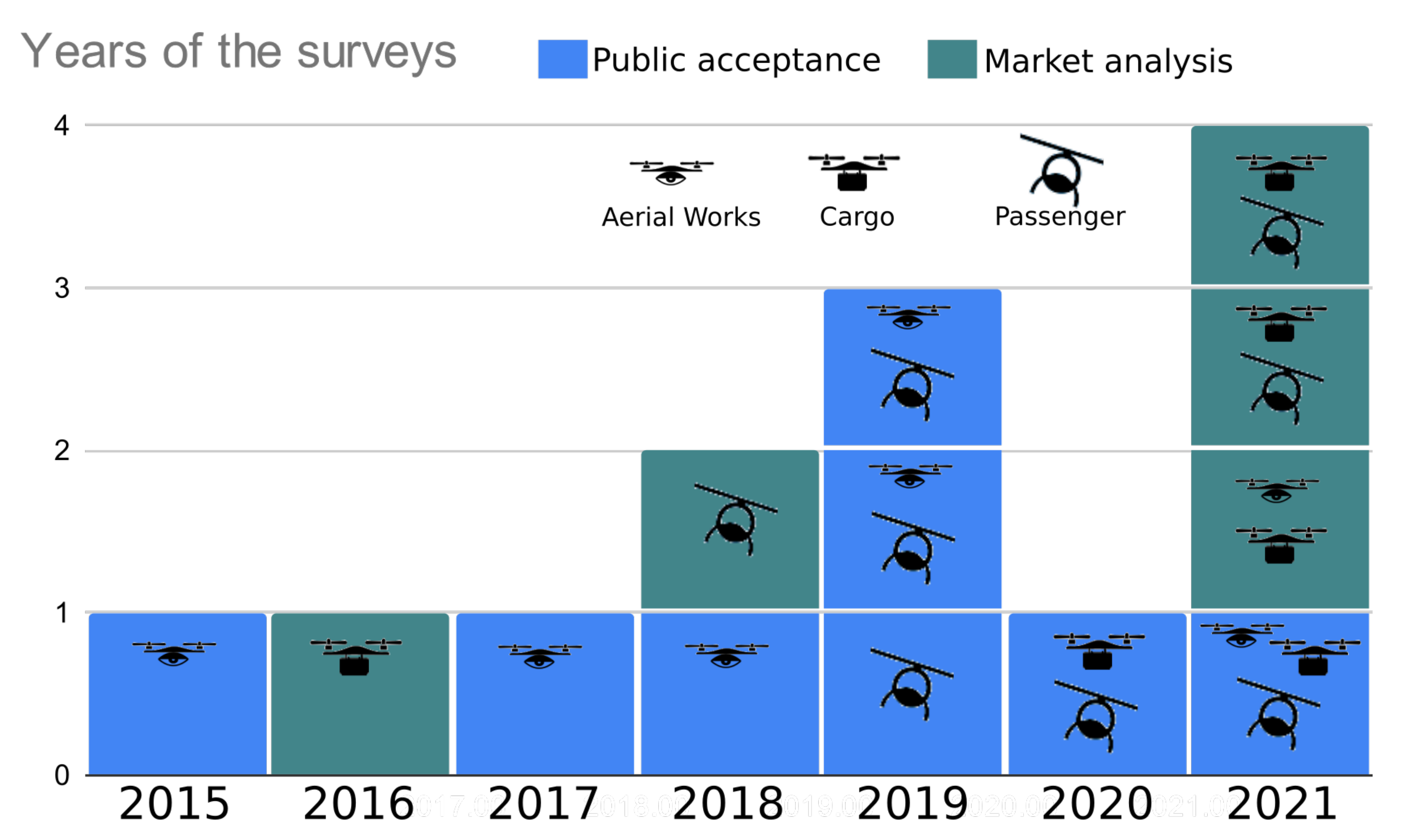
In
Figure 2, the surveys are visualized according to their main focus, such as public acceptance (blue) or market analysis (green). The number of surveys for each year from 2015 to 2021 can be seen on the vertical axis. The different types of drones (surveillance, cargo, and passenger) covered by each questionnaire are also indicated by a picture.
A growing interest in passenger drones can be observed starting from 2018 to 2021. Conversely, the interest in surveillance drones has been decreasing. This may be a reason why privacy concerns have been decreasing over the years in these surveys, while noise and environmental concerns have increased.
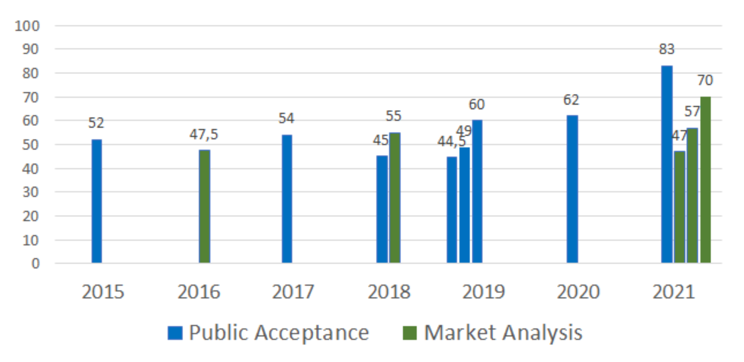
As an overall metric, the level of acceptances of drones and of urban air mobility are shown in
Figure 3. Each bar represents one survey, and they are sorted by year to try to show any trend across time. Again, the color indicates the final focus of the survey: blue for public acceptance and green for market analysis.
As can be seen, the public acceptance has no clear trend over the years but reached the maximum in six years of 83% in 2021 (EASA survey). However, the other surveys of the same year had very different results. The way questions are proposed in these surveys partly explains these differences. In the EASA survey [
17], with the highest acceptance value, the question was the “general attitude towards urban air mobility”. In the Park and Joo survey [
18], also conducted in 2021, but from a market analysis perspective, the question that obtained 47% of positive responses was about the “public’s willingness to use UAM in its initial phase”. This shows how difficult it is to compare survey results.
Surveys, in general, have a first set of questions to classify the public according to their age, gender, and economic status, but also their knowledge about drones, so that the answers can be further studied by groups. Typically, females, elders, and less-educated people have a slightly lower acceptance of drones than the other groups. On the contrary, experts in the field are generally more concerned about safety than laypersons.
Most surveys are also usually accompanied by a scenario of drone usage, and in the market study surveys, the scenarios include a forecast about the cost of the services. Many unknowns are yet to be unveiled: Will safety increase or decrease? Will the projected drone service costs/times be achievable? Will drones generate the expected economical growth? For the moment, only predictions can be provided when conducting surveys, whereas the survey results show clearly that the costs of drone services, as well as the time saved, have a high impact on responses. Drone operations related to health and welfare always have a high level of acceptance, while leisure or business related to leisure are always the least accepted drone operations.
In most recent surveys, we found that quantitative data are obtained from the questionnaire responses, while qualitative information is obtained from a set of persons who are interviewed separately, and whose responses are analyzed with more detail. Typically, this set of responses, referred to as experts, is used to validate and interpret the responses of the questionnaire. However, expert answers usually point towards a positive attitude to drones, as confirmed during the first CORUS-XUAM stakeholder workshop. This workshop analyzed the most critical elements related to UAS/UAM operations along with possible solutions that could enable a sustainable and accepted expansion of drone operations in and around the European cities. In particular, the fifth day of the workshop was dedicated to the analysis of societal impact of drone operations and possible mitigation measures. The responses to the questions in
Table 1 showed a high acceptance rate among the 66 workshop participants, as in the surveys analyzed.
Although public opinions vary with time/country, trends seem to show that between half and three-fourths of the public accepts the deployment of business-related drone operations.
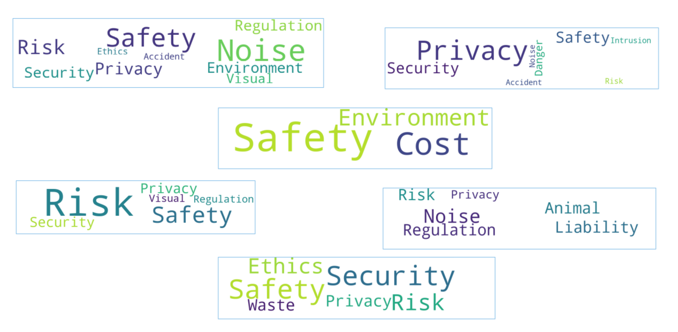
In addition to acceptance, most surveys include questions about public concerns, but they do not use an equivalent set of concerns or the same terminology. To highlight this fact, we used word clouds to process the surveys addressing “public concerns” (see
Figure 4). In word clouds, the most frequently used terms within a document are displayed in larger font size.
As can be seen in these word clouds, public concerns related to drone operations are mostly focused on safety, environment, privacy, and noise. Terms such as animals, visual, and waste are classified as an environmental concern, while others, such as risk and danger, are considered as safety concerns. In addition, we see terms related to the economy, (i.e., cost and liability), or to other topics, such as regulation or ethics.
In the CORUS-XUAM, the workshop participants were asked to select the top three concerns for them, and the results are shown in
Table 2. As most of them came from the aviation sector, it is not surprising to see that the safety concern was selected as the major concern.
It is worth mentioning some specific issues that yield “not in my backyard” responses. The location of vertiports is a good example. People are open to the concept, but would not be happy to have one near their home or office.
The full list of societal concerns that can be identified by the CORUS-XUAM project is as follows:
Environment: noise impact; emissions impact, impacts on animals and flora; recycling; impact of climate change; visual pollution; loss of privacy/intrusion; nuisance.
Safety: safety concerns; security concerns, cybersecurity.
Fairness: lack of transparency; cost of services; competency; liability.
Economy: jobs; economic viability; demand.
As the environmental area has many items, and noise and privacy are highly mentioned as concerns, we treat them separately in the following sections. While analyzing each societal concern, we also hint at possible mitigation measures.
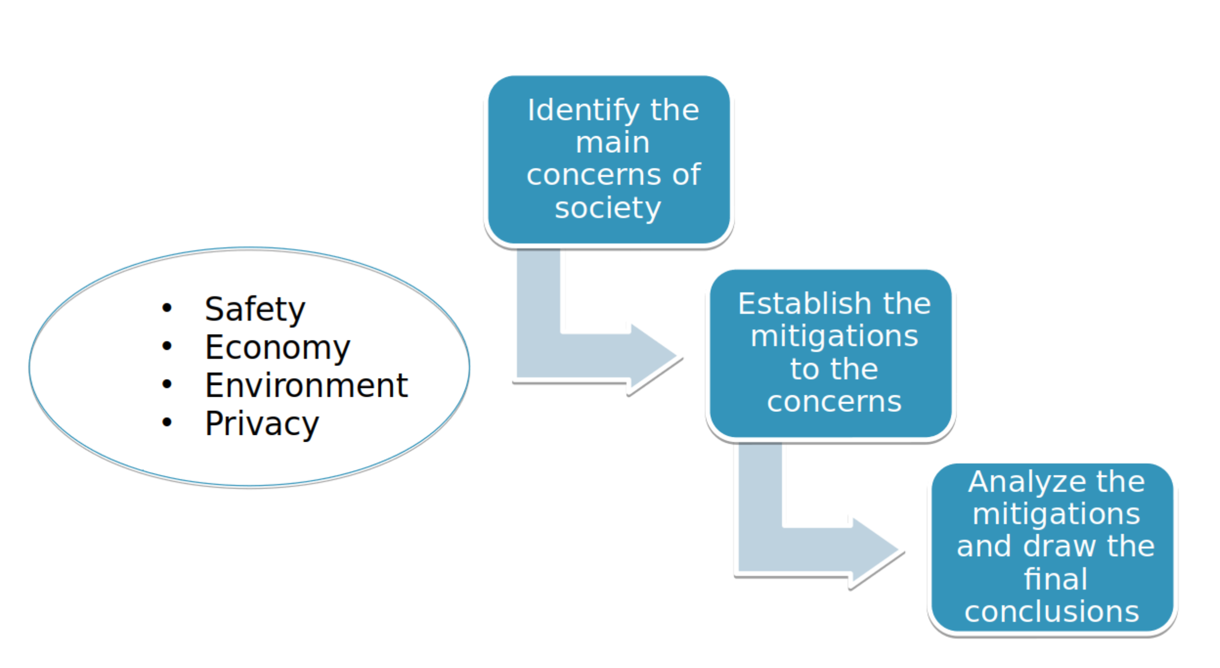
3. Materials and Methods
The procedure followed for defining the mitigation measures and analyzing them is summarized in
Figure 5. First, the main societal concerns were extracted from the surveys. Aspects related to safety, the economy, the environment and noise were the result of this first step, as depicted in the figure. Next, the societal concerns were analyzed during several brainstorming sessions. For each concern, we determined possible actions that could help to minimize its negative perception. The result was a list of mitigation measures, in which each item is an individual action that can mitigate one or several concerns.
Finally, the list of mitigation measures was analyzed to draw conclusions. As part of this process, this list was presented and discussed in the CORUS-XUAM workshop. The majority of the participants felt that it was a good start (details can be seen in
Table 3) but it was still incomplete. During the debate, new potential actions were proposed and added to the existing ones.
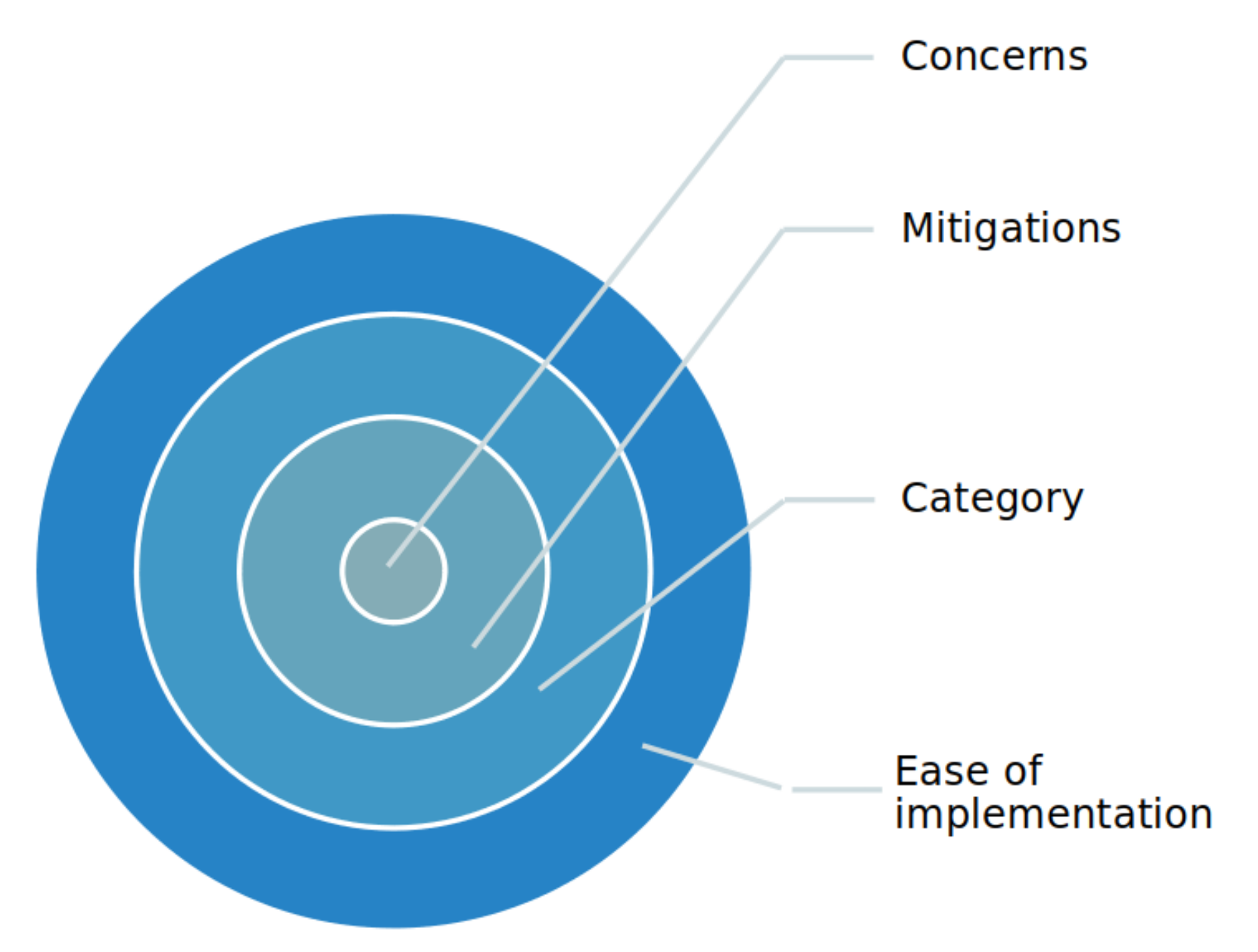
Once the list of mitigation actions is completed, the analysis was performed using the double classification process illustrated in
Figure 6. With the workflow moving from the inside to the outside, we started collecting public concerns and then proposed actions to mitigate such concerns, and finally applied two overlapping classifications: first providing a category to each action and then a level that measures the required effort to implement that action.
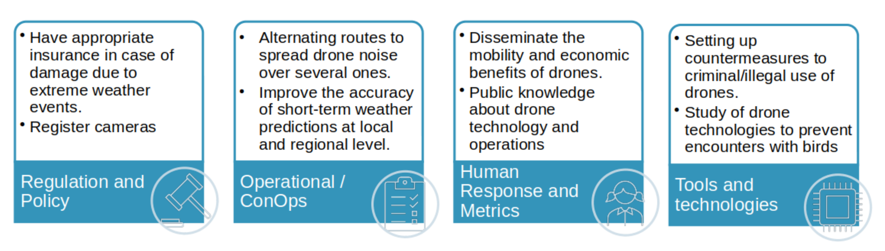
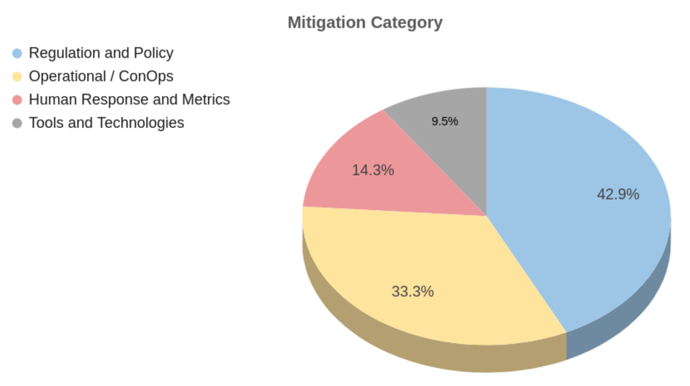
In more detail, the analysis starts by categorizing each mitigation measure according to the scope in which it can be applied. We established four different scopes, or categories, as follows:
Regulation and policy. This category contains the mitigations that should be part of a regulation made by the authorities.
Operational and ConOps. This category includes the mitigation measures related to rules and regulations that enable the safe integration of drones with other airspace users.
Human response and metrics. This category relates to mitigation measures that engage the public.
Tool and technologies. This category includes mitigation measures that can be built into or used by drones.
Figure 7 shows some examples of mitigation for each category. Note that simply rewording a mitigation slightly can move it from one category to another. For instance, “setting up countermeasures to criminal/illegal use of drones” was categorized under “tools and technologies”, but rephrasing it to “make mandatory the use of countermeasures …” would have categorized it under “regulation and policy”.
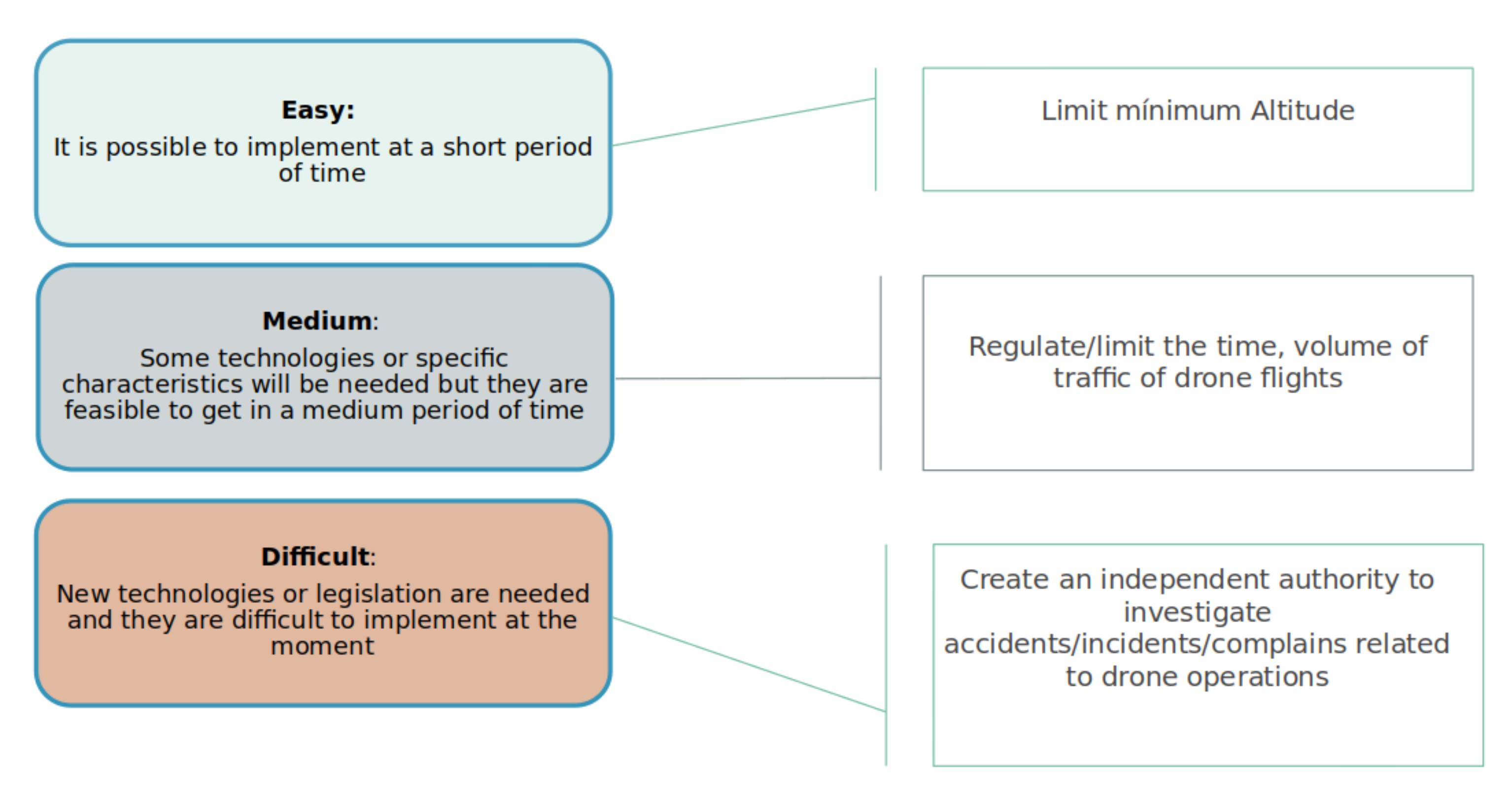
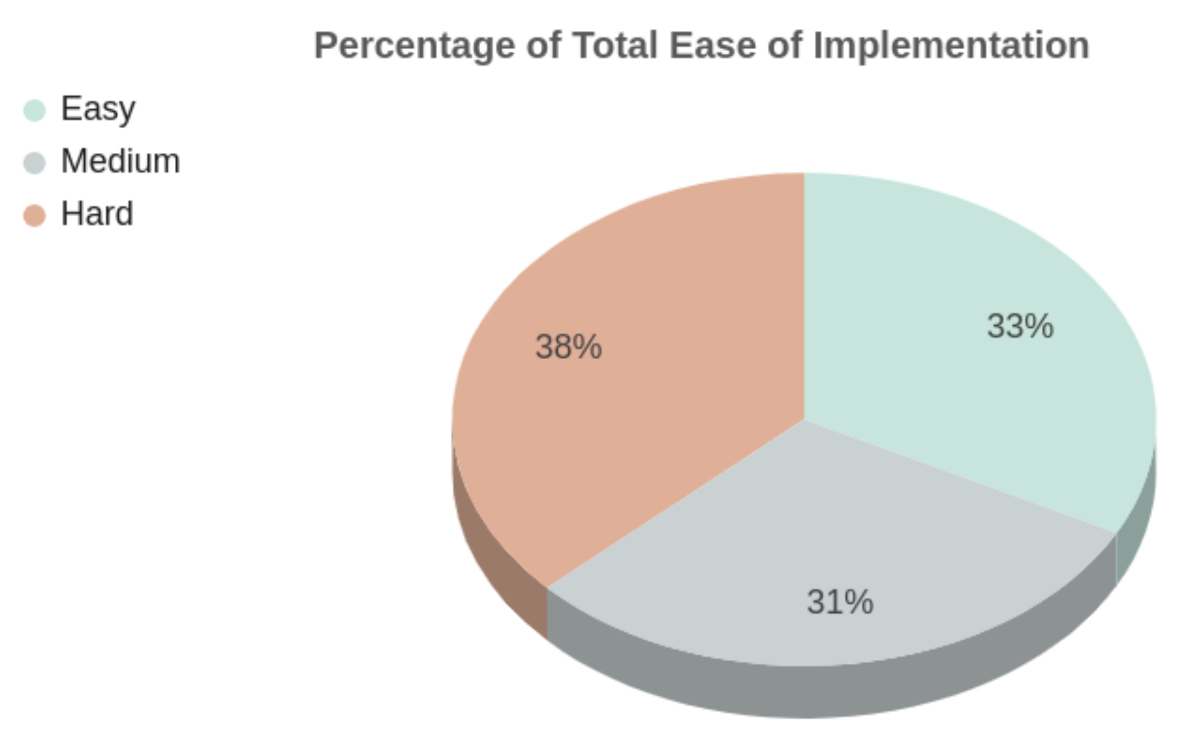
In addition to the category, we assigned each mitigation a second classification in three levels, “easy”, “medium”, and “difficult”, according to its ease of implementation in terms of resources and time.
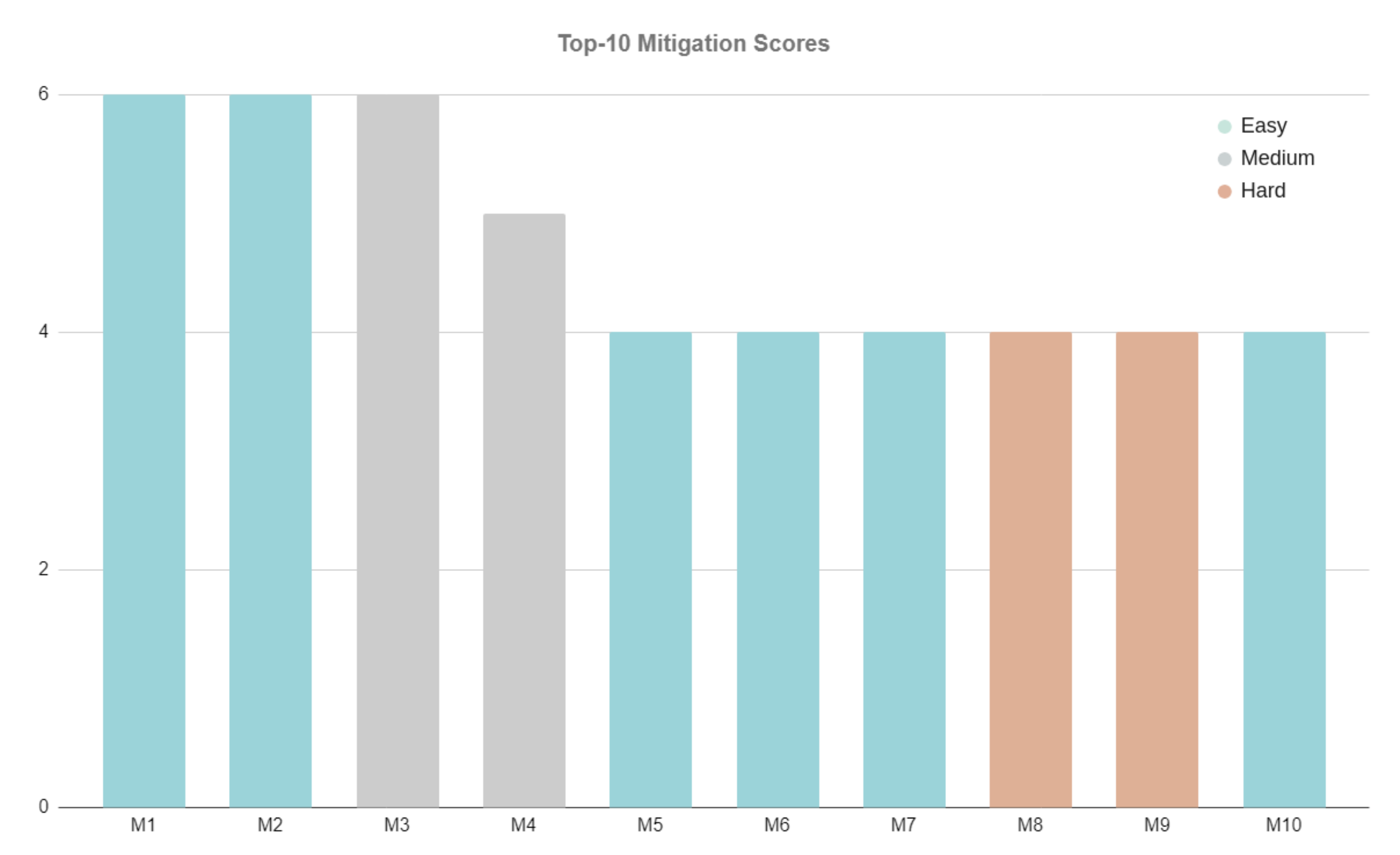
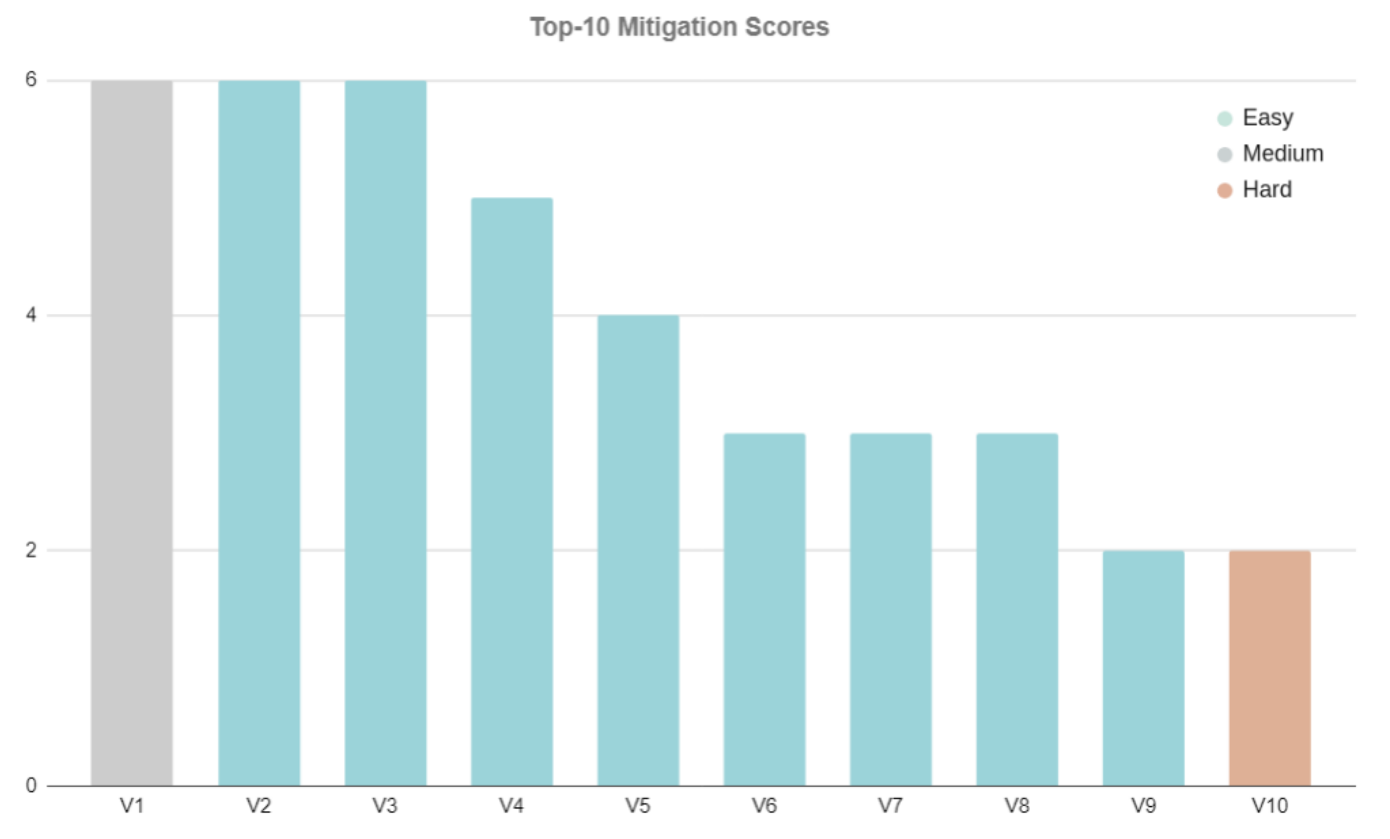
Figure 8 shows some mitigation examples for each of the three levels of ease of implementation. For example, the mitigation “creating an independent authority to investigate accidents/incidents/complaints related to drone operations” is considered to be difficult to implement at the moment because it requires a high level of agreement between stakeholders. In particular, this mitigation measure shall involve regulation bodies which have to follow a lengthy period of legal procedures. In contrast, the mitigation “limit minimum altitude” is an operational action that is easy to implement.
3.1. Scoring of the Mitigations
Given the long list of mitigation measures, we needed a method to rank them from highest to lowest priority. The prioritization process uses a scoring value generated from a dynamic table. The dynamic table is created by reversing the rows and columns of the table used to generate the mitigation measures.
The process for scoring each individual mitigation is the result of adding up the applicability values of that mitigation measure in each and every concern.
Indeed, one mitigation that reduces visual impact may have a negative effect on the safety of the surrounding traffic, but at the same time may be neutral for natural life and for privacy. For this reason, we crossed each mitigation with each concern on the long list of concerns presented in
Section 2 and set
for a positive impact,
for a negative impact, and 0 for a neutral.
This is similar to the process used in the safety operational risk assessment (SORA) methodology [
21]. The final sum of the values of a mitigation provides a numerical proxy of the impact of its applicability. The higher the number, the more positive the impact.
3.2. CORUS-XUAM Mitigations Subset
As a final step for this work, we selected a subset of mitigation measures, mainly from the operational/ConOps category (but not all) that are applicable to very large (drone flight) demonstrations (VLDs) being prepared within the CORUS-XUAM project.
Very-large-scale demonstration (VLD) activities will be at the heart of CORUS-XUAM and will support the integrated operations of UAS/UAM and manned aircraft and the advanced forms of interaction through digital data exchange supported by integrated and advanced U-space services in urban, suburban, and intercity scenarios, as well as in and near ATM-controlled airspace and airports. The VLDs will focus on different types of missions such as passenger transport, delivery, emergency response, and surveillance. The VLDs will use different U-space deployment architectures and state-of-the-art technologies. They will take into account the coordination between ATC and U-space, including interaction with ATCOs and pilots. The VLDs will combine eVTOLs flights with other traffic, and operations in the CTRs of major airports. Vertiport procedures, separation, and data services will also be demonstrated [
22].
The mitigation measures proposed to be tested during VLDs are mainly those that can be implemented by the U-space service providers or any other partner involved. As the VLDs are in the planning phase, at the time of writing this paper, each VLD responds differently to the proposed list of mitigation measures, depending on its mission and capacity.
5. Discussion
The application of actions to mitigate risks is the basis of the SORA methodology [
21]. For instance, to reduce the energy of a falling drone, a common mitigation is the addition of a parachute. While the parachute will, in general, improve safety, it may also introduce new risks and failures, such as an undesired deployment of the parachute. We have to understand that any well-intentioned action may indirectly introduce malicious effects as well.
In the case of the proposed social concern mitigation list, we found a number of contradictory effects.
For instance, we proposed a number of mitigations in relation to the flight trajectory and noise-limiting hover time, flying direct routes, and so on—but also using alternate paths, avoiding certain areas, and limiting speeds. Although they are helpful for reducing the noise on the ground, it is not possible to apply all of them at the same time. Trade-offs need to be elaborated to avoid long route deviations due to protected zones. Other route characteristics, such as altitude, time of day, and maximum capacity, play important roles in the abatement of noise. They should all be taken into account together when selecting the best mitigation strategy for drone operations.
Another example is the location of vertiports. For safety reasons, vertiports should be located in isolated areas, with few air and ground risks, but for economical reasons they should be close to transportation hubs (persons and/or freight). Moreover, the high traffic density of a vertiport can generate a nuisance for neighbors. Using a building ceiling could mitigate this nuisance, but at the cost of increasing the flight risk. A split of opinions is very clearly shown in
Table 6, obtained based on the workshop attendees’ opinions. It seems clear that more research is needed to further develop this and some of the proposed mitigations.
A number of mitigations have been classified as “tools and technologies”. Based on research on clean energy sources, artificial intelligence or new materials are key to reducing societal concerns. A drone with low-noise propellers may be inaudible at 10–15 m of height, thus increasing the minimum altitude noise mitigation. It is especially relevant to note the object avoidance technologies, currently based on near-infrared or ultrasound sensors, that only work at low speeds. Future developments can help to avoid unexpected encounters (i.e., killing birds) at any speed.
Most societal concerns cannot be purely measured objectively. Human perception is highly subjective. A clear example is the experiment reported in the EASA survey [
17] about noise. In a lab, a number of people were requested to order a list of sounds according to what they considered a nuisance. While all sounds were played all at the same volume (80 decibels, which is higher than a vacuum cleaner), responses penalized unknown noise sources more than other, known ones. As the public becomes informed and used to drone characteristic noise, this human factor will change. Moreover, according to [
24], the noise of a VA-X4 taxi drone flying at 300 m produces a noise of 43 decibels, a loudness between the noise of a quiet urban night (40 dBA) and that of light urban traffic (50 dBA). A very interesting review of drone noise emissions and noise effects on humans can be found in [
25]. Furthermore, the effects of drone noise with natural life, especially in birds, seems to be a growing societal concern [EASAsurvey], but scientific studies show that certain frequencies, such as drone high-frequency noise, are not audible to most birds [
26].
A number of proposed mitigations can be adopted in future regulations. However, the role of governments must go beyond the regulatory aspects. Actions are needed to disseminate the benefits of drones as environmentally friendly vehicles, with a capacity for the fast transport of people and goods to be used in emergency situations and a motor of a new economic growth cycle. Simultaneously, the initial support in terms of infrastructure to be deployed (i.e., U-space) are actions needed to foster the new era of transport using drones. The development of this infrastructure still requires decisions about U-space airspace organization to be made. This is also a hot topic for research, as there does not appear to be any consensus based on the expert responses of
Table 7.
Another aspect that governments and authorities should face is the fairness in regard to the access to airspace. Transparency is a tool of fairness as well as a strategy for mitigating citizen concerns about privacy, according to the responses to the workshop poll shown in
Table 8.
On exchange, drone operators shall carefully monitor safety levels to be fully compliant with the regulations. With this paper, we hope to provide them with ideas to help them to improve the social acceptance of drone operations (and thus increase business), especially in urban environments. The authors’ aim is to convince drone operators to be eager to apply the most convenient mitigations to their operations, including dissemination actions and collaboration with researchers of new environmentally friendly technologies for drones.
6. Conclusions
Many governments believe that drone-related business can provide a competitive advantage for developing their country and are taking political and economic measures to foster drone business and urban air mobility. Expectations about drones are to be widely adopted by citizens in urban areas, once some issues are addressed and resolved. The most important ones are safety and societal issues.
Safety issues are largely anticipated in traditional aviation, to reduce risks to airspace users and people, assets, and facilities on the ground. Safety is achieved through thoughtful airspace design, robust and certified industrial processes, and the use of operational mitigation measures, all of them supported by an international regulation. Societal issues are sometimes overlooked before deployment.
This paper proposes to address societal issues similar to safety risks by anticipating and reducing risks (public concerns) prior to deployment. Social acceptance can be facilitated by ensuring mitigation measures that prevent the negative impact of drones on citizens and on the environment. Public concerns are identified, and actions that mitigate them shall be implemented well in advance of urban air mobility widespread deployment. The paper presents the main concerns of society with regard to drone operations, as already captured in some public surveys, and proposes a list of mitigation measures to reduce these concerns. The proposed list was then analyzed and its applicability to individual, very large demonstration urban flights is explained, using the framework of the CORUS-XUAM project. The proposed mitigation measures do not only concern drone operators but also regulators, educational bodies, other airspace stakeholders, infrastructure providers, technology and software developers, and research centers.
Future work includes the analysis of the application of mitigations in the six very large demonstrations of CORUS-XUAM to understand their impact and to fully consolidate the mitigation list proposed in this paper. It also includes new measures and scientific work to provide more detailed data to some mitigation measures, such as the perception of noise in the ground, which will help to suggest limits on altitude and speed. Future observations are needed to understand the interaction with birds. The analysis of images captured during flights will be useful to estimate threats to privacy. Additionally, further work is needed to develop a comprehensive list of mitigation measures, identify regulatory gaps, propose suitable infrastructure deployment, or influence pilot training in the future. Social concerns need to be anticipated and mitigated in advance if urban air mobility is to become an accepted part of a modern, efficient, environmentally friendly, and competitive future mobility.


