
Artificial Intelligence and Big Data Analytics for Seismic Hazard Assessment: Methodological Advances and Computational Frameworks for the Marmara Region, Türkiye



Abstract
1. Introduction
1.1. Background
1.2. Research Problem and Objectives
2. Seismic Vulnerability in Türkiye: From Tectonic Plate Interactions to Historical Disaster Impacts
2.1. Geology and Tectonics in Türkiye
2.2. Historical Outline of Seismic Events in Türkiye
2.3. Seismic Risk Assessment and the Distinction Between EEW and Earthquake Forecasting
3. Research Gap Identification and Contribution
4. Big Data Processing in Geophysics
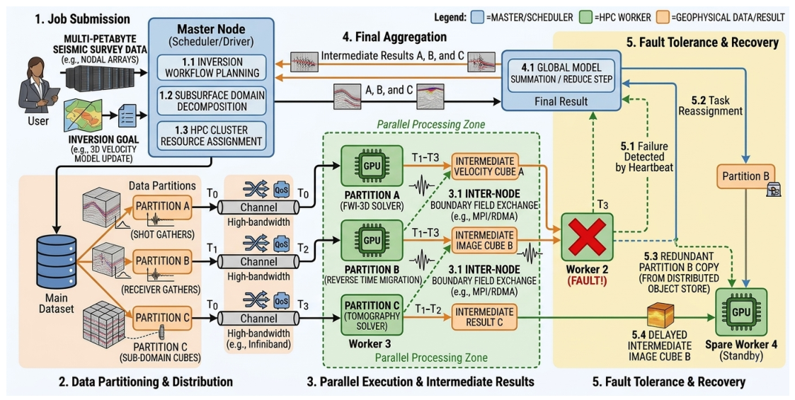
4.1. Hybrid Computing: HPC and Cloud Architecture
4.2. Physics-Informed Neural Networks (PINNs) and Deep Learning for Phase Picking
4.3. Influence of Seismic Wave Diversity on Signal Processing in Marmara Geophysical Monitoring
5. Cluster Computing and Distributed Data Processing
5.1. Architecture Paradigms for Marmara Regional Seismology
5.2. Apache Spark and PySpark for Seismic Data Processing
5.2.1. PySpark-Based Streaming and Windowed Processing of Seismic Waveforms
| Listing 1. PySpark ingestion and windowing of continuous seismic waveform data from AFAD-compatible MiniSEED streams. |
 |
5.2.2. Bandpass Filtering of Seismic Streams
| Listing 2. Application of a Butterworth bandpass filter to seismic waveforms using ObsPy within a PySpark UDF to remove cultural noise. |
 |
5.2.3. STA/LTA Seismic Event Detection
| Listing 3. Short-term average/long-term average (STA/LTA) event detection implemented as a distributed PySpark operation across the AFAD station network. |
 |
5.2.4. Magnitude Estimation and Catalog Validation
| Listing 4. Local magnitude estimation using peak amplitude and statistical validation (RMSE, precision, recall) against the AFAD earthquake catalog. |
 |
5.2.5. Ambient Noise Cross-Correlation Tomography
| Listing 5. Distributed ambient noise cross-correlation for surface wave tomography using PySpark’s Cartesian join across all Marmara station pairs. |
 |
5.2.6. PhaseNet-Based Automated Phase Picking
| Listing 6. Automated P- and S-wave phase picking using PhaseNet integrated into a PySpark Gold-layer pipeline with pick uncertainty estimation. |
 |
5.2.7. Real-Time Earthquake Early Warning Pipeline
| Listing 7. End-to-end EEW alert pipeline using Spark Structured Streaming, monitoring processing latency to maintain the “Golden Seconds” constraint. |
 |
5.2.8. Probabilistic Seismic Hazard Estimation
| Listing 8. Gutenberg–Richter b-value estimation and exceedance probability computation from the AFAD catalog using PySpark SQL and NumPy. |
 |
6. Databricks: Cloud-Native Geophysics
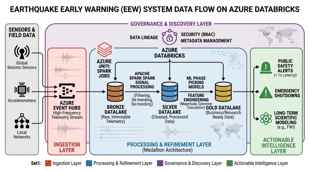
6.1. From Raw Waves to Real-Time Alerts: The Medallion Architecture
6.2. Geophysical Data Hubs in Türkiye: Distributed Architecture
6.3. Governance, Integration Planning, and Uncertainty Management
6.4. Implementation Roadmap Development
7. Deterministic Infrastructure and Performance Optimization for EEW Systems
7.1. Computational Tiering and Latency Requirements
7.2. GPU-Accelerated Systems for Marmara Region Earthquake Alerts
7.3. Hybrid Cluster Architecture for Sub-Second Earthquake Detection
8. Decision Framework Development in Geophysical Big Data
8.1. A Tiered Framework for Life-Safety in Marmara Seismic Cloud Systems
8.2. Combining Edge Filtering and Serverless Computing for Seismic Analysis
8.3. Operational Constraints for Istanbul’s Seismic Monitoring Infrastructures
8.4. Balancing Latency and Durability Through a Phased Implementation Framework
- Phase 1 focuses on Intelligent Storage Tiering, leveraging automated lifecycle policies to migrate petabytes of legacy seismic archives to deep-cold tiers, yielding an immediate reduction in storage overhead without impacting real-time telemetry.
- Phase 2 introduces Hybrid Compute Orchestration, balancing a baseline of Reserved Instances for mission-critical P-wave detection with elastic Spot instances for batch-oriented research, effectively slashing compute costs while maintaining the durability required for Marmara Sea resilience.
- Phase 3 implements Edge Processing at sensor sites along the North Anatolian Fault to filter seismic noise locally, significantly suppressing network egress fees and latency.
8.5. Risk-Weighted Optimization Strategy for EEW in the Marmara Sea
8.6. AI-Driven Framework for Managing Cloud Costs in Seismic Monitoring
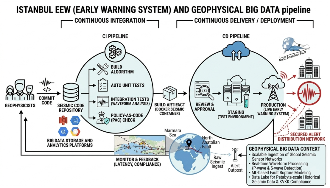
8.7. Elastic Scaling and PaC in Istanbul’s EEW Framework
9. Conclusions
Author Contributions
Funding
Institutional Review Board Statement
Informed Consent Statement
Data Availability Statement
Acknowledgments
Conflicts of Interest
Abbreviations
| AFAD | Disaster and Emergency Management Authority |
| AI | Artificial Intelligence |
| API | Application Programming Interface |
| CCS | Carbon Capture and Storage |
| CNN | Convolutional Neural Networks |
| DAS | Distributed Acoustic Sensing |
| DAG | Directed Acyclic Graph |
| DL | Deep Learning |
| EEW | Earthquake Early Warning |
| ETL | Extract, Transform, and Load |
| FWI | Full Waveform Inversion |
| GPU | Graphics Processing Unit |
| GNNs | Graph Neural Networks |
| HPC | High-Performance Computing |
| I/O | Input-Output |
| KOERI | Kandilli Observatory and Earthquake Research Institute |
| KVKK | Kişisel Verileri Korunması Kanunu |
| LSTM | Long Short-Term Memory |
| ML | Machine Learning |
| NAF | North Anatolian Fault |
| NAFZ | North Anatolian Fault Zone |
| NEMC | National Earthquake Monitoring Center |
| PINN | Physics-Informed Neural Network |
| PaC | Policy-as-Code |
| QC | Quality Control |
| RMSE | Root Mean Square Error |
| RNN | Recurrent Neural Network |
| SaaS | Software as a Service |
| SEG-Y | Society of Exploration Geophysicists – Y format |
| SHRA | Seismic Hazard Risk Assessment |
| SNR | Signal-to-Noise Ratio |
| SQL | Structured Query Language |
| STA/LTA | Short-Term Average/Long-Term Average |
| UCD | Unit Cost of Detection |
References
- Ahmed, S.M.S.; Güneyli, H. The evolution of seismic tomography in earth sciences—Advancements, limitations, and its AI-enabled future (A critical review). Earthq. Res. Adv. 2025, 100425. [Google Scholar] [CrossRef]
- Allen, R.M.; Melgar, D. Earthquake Early Warning: Advances, Scientific Challenges, and Societal Needs. Annu. Rev. Earth Planet. Sci. 2019, 47, 361–388. [Google Scholar] [CrossRef]
- Kanamori, H. Real-time seismology and earthquake damage mitigation. Annu. Rev. Earth Planet. Sci. 2005, 33, 195–214. [Google Scholar] [CrossRef]
- U.S. Geological Survey. Earthquake Monitoring and Data Processing. 2020. Available online: https://earthquake.usgs.gov/monitoring/ (accessed on 5 May 2026).
- Incorporated Research Institutions for Seismology (IRIS). Data Services and Real-Time Seismic Networks. 2018. Available online: https://www.iris.edu/hq/ (accessed on 5 May 2026).
- Sadhukhan, B. Chapter 2—Earthquake early warning systems. In Can Artificial Intelligence Aid in Forecasting Earthquakes? Elsevier: Amsterdam, The Netherlands, 2026; pp. 41–80. [Google Scholar] [CrossRef]
- Beroza, G.C.; Segou, M.; Mostafa Mousavi, S. Machine learning and earthquake forecasting—Next steps. Nat. Commun. 2021, 12, 4761. [Google Scholar] [CrossRef]
- Ni, Y.; Denolle, M.A.; Münchmeyer, J.; Wang, Y.; Feng, K.F.; Suarez, C.G.J.; Thomas, M.A.; Trabant, C.; Hamilton, A.; Mencin, D. A review of cloud computing and storage in seismology. Geophys. J. Int. 2025, 243, ggaf322. [Google Scholar] [CrossRef]
- Perol, T.; Gharbi, M.; Denolle, M. Convolutional neural network for earthquake detection and location. Sci. Adv. 2018, 4, e1700578. [Google Scholar] [CrossRef]
- Chen, G.; Liu, W.; Hurter, S.; Zhao, P.; Zhang, M.; Liu, S. From edge detection to deep learning: Image processing methods for seismic horizon tracking. Comput. Phys. Commun. 2025, 315, 109717. [Google Scholar] [CrossRef]
- Bergen, K.J.; Johnson, P.A.; de Hoop, M.V.; Beroza, G.C. Machine learning for data-driven discovery in solid Earth geoscience. Science 2019, 363, eaau0323. [Google Scholar] [CrossRef]
- Moshou, A.; Konstantaras, A.; Argyrakis, P.; Petrakis, N.S.; Kapetanakis, T.N.; Vardiambasis, I.O. Data management and processing in seismology: An application of big data analysis for the doublet earthquake of 2021, 03 March, Elassona, Central Greece. Appl. Sci. 2022, 12, 7446. [Google Scholar] [CrossRef]
- Amador Luna, D.; Alonso-Chaves, F.M.; Fernández, C. Kernel density estimation for the interpretation of seismic big data in tectonics using QGIS: The Türkiye–Syria earthquakes (2023). Remote Sens. 2024, 16, 3849. [Google Scholar] [CrossRef]
- Zhang, Z.; Kang, J.; Wang, J.; Fang, D.; Liu, Y. Earthquake risk assessment in seismically active areas of Qinghai Province based on geographic big data. Atmosphere 2024, 15, 648. [Google Scholar] [CrossRef]
- Davis, W.; Hunt, C.R. Knowledge graphs for seismic data and metadata. Appl. Comput. Geosci. 2024, 21, 100151. [Google Scholar] [CrossRef]
- Incorporated Research Institutions for Seismology (IRIS). IRIS Data Management Center Overview. 2015. Available online: https://ds.iris.edu/ds/nodes/dmc/ (accessed on 5 May 2026).
- Laney, D. 3D Data Management: Controlling Data Volume, Velocity, and Variety. META Group Res. Note 2001, 6, 1. [Google Scholar]
- Kitchin, R. The Data Revolution: Big Data, Open Data, Data Infrastructures and Their Consequences; SAGE Publications: Thousand Oaks, CA, USA, 2014. [Google Scholar] [CrossRef]
- Hashem, I.A.T.; Yaqoob, I.; Anuar, N.B.; Mokhtar, S.; Gani, A.; Khan, S.U. The rise of “big data” on cloud computing: Review and open research issues. Inf. Syst. 2015, 47, 98–115. [Google Scholar] [CrossRef]
- Arrowsmith, S.J.; Trugman, D.T.; MacCarthy, J.; Bergen, K.J.; Lumley, D.; Magnani, M.B. Big data seismology. Rev. Geophys. 2022, 60, e2021RG000769. [Google Scholar] [CrossRef]
- Gandomi, A.; Haider, M. Beyond the hype: Big data concepts, methods, and analytics. Int. J. Inf. Manag. 2015, 35, 137–144. [Google Scholar] [CrossRef]
- Allen, R.M.; Gasparini, P.; Kamigaichi, O.; Böse, M. The status of earthquake early warning around the world: An introductory overview. Seismol. Res. Lett. 2009, 80, 682–693. [Google Scholar] [CrossRef]
- Ma, Y.; Wu, H.; Wang, L.; Huang, B.; Ranjan, R.; Zomaya, A.; Jie, W. Remote sensing big data computing: Challenges and opportunities. Future Gener. Comput. Syst. 2015, 51, 47–60. [Google Scholar] [CrossRef]
- Chen, M.; Mao, S.; Liu, Y. Big data: A survey. Mob. Netw. Appl. 2014, 19, 171–209. [Google Scholar] [CrossRef]
- Zhao, T.; Wang, S.; Ouyang, C.; Chen, M.; Liu, C.; Zhang, J.; Yu, L.; Wang, F.; Xie, Y.; Li, J.; et al. Artificial intelligence for geoscience: Progress, challenges, and perspectives. Innovation 2024, 5, 100691. [Google Scholar] [CrossRef] [PubMed]
- Stocks, K.I.; Schramski, S.; Virapongse, A.; Kempler, L. Geoscientists’ perspectives on cyberinfrastructure needs: A collection of user scenarios. Data Sci. J. 2019, 18, 21. [Google Scholar] [CrossRef]
- Vance, T.C.; Huang, T.; Butler, K.A. Big data in Earth science: Emerging practice and promise. Science 2024, 383, eadh9607. [Google Scholar] [CrossRef]
- Liu, J.; Li, J.; Li, W.; Wu, J. Rethinking big data: A review on the data quality and usage issues. ISPRS J. Photogramm. Remote Sens. 2016, 115, 134–142. [Google Scholar] [CrossRef]
- Mousavi, S.M.; Zhu, W.; Sheng, Y.; Beroza, G.C. CRED: A deep residual network of convolutional and recurrent units for earthquake signal detection. Sci. Rep. 2019, 9, 10267. [Google Scholar] [CrossRef]
- Kong, Q.; Trugman, D.T.; Ross, Z.E.; Bianco, M.J.; Meade, B.J.; Gerstoft, P. Machine learning in seismology: Turning data into insights. Seismol. Res. Lett. 2019, 90, 3–14. [Google Scholar] [CrossRef]
- Sopher, D. Converting scanned images of seismic reflection data into SEG-Y format. Earth Sci. Inform. 2018, 11, 241–255. [Google Scholar] [CrossRef]
- Lemenkova, P.; De Plaen, R.; Lecocq, T.; Debeir, O. Computer vision algorithms of DigitSeis for building a vectorised dataset of historical seismograms from the archive of Royal Observatory of Belgium. Sensors 2023, 23, 56. [Google Scholar] [CrossRef]
- Baumann, P.; Mazzetti, P.; Ungar, J.; Barbera, R.; Barboni, D.; Beccati, A.; Bigagli, L.; Boldrini, E.; Bruno, R.; Calanducci, A.; et al. Big data analytics for earth sciences: The EarthServer approach. Int. J. Digit. Earth 2016, 9, 3–29. [Google Scholar] [CrossRef]
- Zhu, W.; Beroza, G.C. PhaseNet: A deep-neural-network-based seismic arrival-time picking method. Geophys. J. Int. 2019, 216, 261–273. [Google Scholar] [CrossRef]
- Sen, T.K. Probabilistic Seismic Hazard Analysis. In Fundamentals of Seismic Loading on Structures; Sen, T.K., Ed.; Wiley: Hoboken, NJ, USA, 2009. [Google Scholar] [CrossRef]
- Liggins, F.; Betts, R.A.; McGuire, B. Projected Future Climate Changes in the Context of Geological and Geomorphological Hazards. In Climate Forcing of Geological Hazards; McGuire, B., Maslin, M., Eds.; Wiley: Hoboken, NJ, USA, 2013. [Google Scholar] [CrossRef]
- Dowrick, D. Seismic Hazard Assessment. In Earthquake Resistant Design and Risk Reduction; Dowrick, D., Ed.; Wiley: Hoboken, NJ, USA, 2009. [Google Scholar] [CrossRef]
- Liu, Y.; Gu, Y.; Zhang, H. Seismic risk assessment and damage analysis: Emerging trends and new developments. J. Saf. Sci. Resil. 2024, 5, 365–381. [Google Scholar] [CrossRef]
- Istanbul Project Coordination Unit. Istanbul Seismic Risk Mitigation and Emergency Preparedness Project (ISMEP): Activity Report, February 2006–February 2026; Istanbul Governorship, Republic of Türkiye: Istanbul, Turkey, 2026. Available online: https://www.ipkb.gov.tr/wp-content/uploads/2026/03/ISMEP-ACTIVITY-REPORT-2026-EN.pdf (accessed on 24 May 2026).
- Başaran-Uysal, A.; Sezen, F.; Özden, S.; Karaca, Ö. Classification of residential areas according to physical vulnerability to natural hazards: A case study of Çanakkale, Türkiye. Disasters 2014, 38, 202–226. [Google Scholar] [CrossRef]
- Sunil Kandregula, R.; Kothyari, G.C.; Chauhan, G.; Thakkar, M.G. Tectono-geomorphic records of neotectonic activity along the Kachchh Mainland fault in a seismically active intraplate setting, Kachchh paleo-rift basin, Western India. J. Asian Earth Sci. 2024, 276, 106302. [Google Scholar] [CrossRef]
- Korkmaz, K.A.; Ay, Z.; Sari, A.; Celik, I.D. Probabilistic seismic risk assessment of hall buildings in Türkiye. Struct. Des. Tall Spec. Build. 2013, 22, 415–439. [Google Scholar] [CrossRef]
- Abdik, Y.; Ocakoğlu, N.; Kaypak, B. Analysis of the active tectonics of the Aşkale-Pasinler-Horasan Basins (Eastern Anatolia) using multichannel seismic reflection and stratigraphic data. J. Afr. Earth Sci. 2026, 235, 105950. [Google Scholar] [CrossRef]
- McKenzie, D. Active Tectonics of the Mediterranean Region. Geophys. J. Int. 1972, 30, 109–185. [Google Scholar] [CrossRef]
- Le Pichon, X.; Kreemer, C. The Miocene-to-Present Kinematics of the Eastern Mediterranean and Adjacent Areas and Its Relationship to Plume-Driven Central Europe-Anatolia Rotations. Annu. Rev. Earth Planet. Sci. 2010, 38, 323–351. [Google Scholar] [CrossRef]
- Barka, A. The North Anatolian fault zone. Ann. Tectonicae 1992, 6, 164–195. [Google Scholar]
- Sengör, A.M.C.; Tüysüz, O.; Imren, C.; Sakınç, M.; Eyidoğan, H.; Görür, N.; Le Pichon, X.; Rangin, C. The North Anatolian Fault: A new look. In The North Anatolian Fault: A New Look; Geological Society of America Special Papers; GSA Publication: Boulder, CO, USA, 2005; Volume 393, pp. 1–72. [Google Scholar] [CrossRef]
- Jolivet, R.; Jara, J.; Dalaison, M.; Rouet-Leduc, B.; Özdemir, A.; Dogan, U.; Çakir, Z.; Ergintav, S.; Dubernet, P. Daily to centennial behavior of aseismic slip along the central section of the North Anatolian Fault. J. Geophys. Res. Solid Earth 2023, 128, e2022JB026018. [Google Scholar] [CrossRef]
- Stein, R.S.; Barka, A.A.; Dieterich, J.H. Progressive failure on the North Anatolian fault since 1939 by structural stress triggering. Geophys. J. Int. 1997, 128, 594–604. [Google Scholar] [CrossRef]
- Schiffer, C.; Eken, T.; Rondenay, S.; Taymaz, T. Localized crustal deformation along the central North Anatolian Fault Zone revealed by joint inversion of P-receiver functions and P-wave polarizations. Geophys. J. Int. 2019, 217, 682–702. [Google Scholar] [CrossRef]
- Andrieux, J.; Över, S.; Poisson, A.; Bellier, O. The North Anatolian Fault Zone: Distributed Neogene deformation in its northward convex part. Tectonophysics 1995, 243, 135–154. [Google Scholar] [CrossRef]
- Altinok, Y.; Alpar, B.; Özer, N.; Aykurt, H. Revision of the tsunami catalogue affecting Turkish coasts and surrounding regions. Nat. Hazards Earth Syst. Sci. 2011, 11, 273–291. [Google Scholar] [CrossRef]
- Papazachos, B.C.; Papazachou, C. The Earthquakes of Greece; Ziti Publications: Thessaloniki, Greece, 2003; Available online: https://ziti.gr/vivlio/papazaxos-vasilis-papazaxoy-katerina-the-earthquakes-of-greece/ (accessed on 24 May 2026).
- Okal, E.A.; Synolakis, C.E.; Uslu, B.; Kalligeris, N.; Voukouvalas, E. The 1956 earthquake and tsunami in Amorgos, Greece. Geophys. J. Int. 2009, 178, 1533–1554. [Google Scholar] [CrossRef]
- Papadopoulos, G.A.; Fokaefs, A. Strong tsunamis in the Mediterranean Sea: A re-evaluation. ISET J. Earthq. Technol. 2005, 42, 159–170. [Google Scholar] [CrossRef]
- Burton, P.W.; McGonigle, R.; Makropoulos, K.C.; Üçer, S.B. Seismic risk in Türkiye, the Aegean and the eastern Mediterranean: The occurrence of large magnitude earthquakes. Geophys. J. R. Astron. Soc. 1984, 78, 475–506. [Google Scholar] [CrossRef]
- Yalciner, A.C.; Alpar, B.; Altinok, Y.; Ozbay, I.; Imamura, F. Tsunamis in the Sea of Marmara: Historical documents for the past, models for the future. Mar. Geol. 2002, 190, 445–463. [Google Scholar] [CrossRef]
- Ambraseys, N.N. The Seismicity of the Marmara Sea Area 1800–1899. J. Seismol. 2000, 4, 377–401. [Google Scholar] [CrossRef]
- Altinok, Y.; Tinti, S.; Alpar, B.; Yalçıner, A.C.; Ersoy, Ş.; Bortolucci, E.; Armigliato, A. The Tsunami of August 17, 1999 in Izmit Bay, Turkey. Nat. Hazards 2001, 24, 133–146. [Google Scholar] [CrossRef]
- Inan, S.; Ergintav, S.; Saatçilar, R.; Tüzel, B.; İravul, Y. Turkey makes major investment in earthquake research. Eos Trans. Am. Geophys. Union 2007, 88, 333–334. [Google Scholar] [CrossRef]
- Parsons, T. Recalculated probability of M ≥ 7 earthquakes beneath the Sea of Marmara, Turkey. J. Geophys. Res. Solid Earth 2004, 109, B05304. [Google Scholar] [CrossRef]
- Yao, D.; Peng, Z.; Ding, C.; Sandvol, E.; Godoladze, T.; Yetirmishli, G. Dynamically triggered tectonic tremors and earthquakes in the Caucasian region following the 2023 Kahramanmaraş, Türkiye, earthquake sequence. Geophys. Res. Lett. 2024, 51, e2024GL110786. [Google Scholar] [CrossRef]
- DeSalvio, N.D.; Fan, W. Ubiquitous Earthquake dynamic triggering in southern California. J. Geophys. Res. Solid Earth 2023, 128, e2023JB026487. [Google Scholar] [CrossRef]
- Akinci, A.; Dindar, A.A.; Bal, I.E.; Ertuncay, D.; Smyrou, E.; Cheloni, D. Characteristics of strong ground motions and structural damage patterns from the February 6th, 2023 Kahramanmaraş earthquakes, Türkiye. Nat. Hazards 2025, 121, 1209–1239. [Google Scholar] [CrossRef]
- Toprak, S.; Zulfikar, A.C.; Mutlu, A.; Tugsal, U.M.; Nacaroglu, E.; Karabulut, S.; Ceylan, M.; Ozdemir, K.; Parlak, S.; Dal, O.; et al. The aftermath of 2023 Kahramanmaraş earthquakes: Evaluation of strong motion data, geotechnical, building, and infrastructure issues. Nat. Hazards 2025, 121, 2155–2192. [Google Scholar] [CrossRef]
- Yılmaz, S.; Arslan, M.; Demir, A.D.; Yavru, T.E.; Yılmaz, E.İ.; Cebir, F.; Aydın, Ç.; Baş, G.Y.; Demir, S. Seismic damage assessment of historical mosques and minarets in Antakya/Türkiye after the February 6, 2023, Kahramanmaraş earthquake sequence. Eng. Fail. Anal. 2025, 182, 110125. [Google Scholar] [CrossRef]
- Tiryakioğlu, İ.; Aktuğ, B.; Yiğit, C.Ö.; Yavaşoğlu, H.H.; Sözbilir, H.; Özkaymak, Ç.H.; Poyraz, F.; Taneli, E.; Bulut, F.; Doğru, A.; et al. Slip distribution and source parameters of the 20 July 2017 Bodrum-Kos earthquake (Mw6.6) from GPS observations. Geodin. Acta 2017, 30, 1–14. [Google Scholar] [CrossRef]
- Hussain, E.; Kalaycıoğlu, S.; Milliner, C.W.D.; Çakir, Z. Preconditioning the 2023 Kahramanmaraş (Türkiye) earthquake disaster. Nat. Rev. Earth Environ. 2023, 4, 287–289. [Google Scholar] [CrossRef]
- Carena, S.; Friedrich, A.M.; Verdecchia, A.; Kahle, B.; Rieger, S.; Kübler, S. Identification of source faults of large earthquakes in the Türkiye-Syria border region between 1000 CE and the present, and their relevance for the 2023 Mw 7.8 Pazarcık earthquake. Tectonics 2023, 42, e2023TC007890. [Google Scholar] [CrossRef]
- Özel, N.M.; Ergintav, S.; Turhan, F.; Konca, A.Ö.; Aksarı, D.; Ergün, T. Earthquake Early Warning System for the Marmara Region. In Proceedings of the EGU General Assembly 2026, Vienna, Austria, 3–8 May 2026. EGU26-17285. [Google Scholar] [CrossRef]
- Eren, S. Development of Earthquake Early Warning Systems in Marmara Region: A Hybrid Model Utilizing Mosque Loudspeakers. Int. J. Environ. Geoinformatics 2025, 12, 61–71. [Google Scholar] [CrossRef]
- Speciale, S.; Picozzi, M.; Iervolino, I.; Zollo, A.; Caruso, A.; Colombelli, S.; Emolo, A.; Elia, L.; Martino, C.; Festa, G. The first Earthquake Early Warning System for the high-speed railway in Italy: Enhancing rapidness and operational efficiency during seismic events. Nat. Hazards Earth Syst. Sci. (NHESS) 2026, 26, 299–315. [Google Scholar] [CrossRef]
- Rudin, C. Stop explaining black box machine learning models for high stakes decisions and use interpretable models instead. Nat. Mach. Intell. 2019, 1, 206–215. [Google Scholar] [CrossRef]
- Liu, B.; Gong, M.; Wang, X.; Zhou, B.; Jia, J. Real-time seismic damage assessment framework of RC frames using deep learning and monitoring data. J. Build. Eng. 2026, 123, 115834. [Google Scholar] [CrossRef]
- Xue, J.; Huang, Q.; Wu, S.; Zhao, L.; Ma, B. Real-time dual-parameter full-waveform inversion of GPR data based on robust deep learning. Geophys. J. Int. 2024, 238, 1755–1771. [Google Scholar] [CrossRef]
- Witte, P.; Louboutin, M.; Kukreja, N.; Luporini, F.; Lange, M.; Gorman, G.; Herrmann, F. A large-scale framework for symbolic implementations of seismic inversion algorithms in Julia. Geophysics 2019, 84, 1–60. [Google Scholar] [CrossRef]
- Abdellaziz, A.; Brossier, R.; Métivier, L.; Oudet, É. Optimal experimental design for full waveform inversion using a wavenumber sampling criterion—part 1: 2-D to methodological development. Geophys. J. Int. 2024, 240, 1429–1459. [Google Scholar] [CrossRef]
- Virieux, J.; Operto, S. An overview of full-waveform inversion in exploration geophysics. Geophysics 2009, 74, WCC1–WCC26. [Google Scholar] [CrossRef]
- Peter, D.; Komatitsch, D.; Luo, Y.; Martin, R.; Le Goff, N.; Casarotti, E.; Pelties, C.; Ampuero, J.P.; Etienne, V.; Hendrickson, B.; et al. Forward and adjoint simulations of seismic wave propagation on fully unstructured hexahedral meshes. Geophys. J. Int. 2011, 186, 721–739. [Google Scholar] [CrossRef]
- Ejarque, J.; Badia, R.M.; Albertin, L.; Aloisio, G.; Baglione, E.; Becerra, Y.; Boschert, S.; Berlin, J.R.; D’Anca, A.; Elia, D.; et al. Enabling dynamic and intelligent workflows for HPC, data analytics, and AI convergence. Future Gener. Comput. Syst. 2022, 134, 414–429. [Google Scholar] [CrossRef]
- Assunção, M.D.; Calheiros, R.N.; Bianchi, S.; Netto, M.A.; Buyya, R. Big data computing and clouds: Trends and future directions. J. Parallel Distrib. Comput. 2015, 79, 3–15. [Google Scholar] [CrossRef]
- Parisi, F.; Nettis, A.; Uva, G. Machine learning-aided cloud analysis for seismic fragility assessment of multi-span bridges. Eng. Struct. 2025, 343, 121175. [Google Scholar] [CrossRef]
- Krauss, Z.; Ni, Y.; Henderson, S.; Denolle, M. Seismology in the cloud: Guidance for the individual researcher. Seismica 2023, 2, 1–12. [Google Scholar] [CrossRef]
- MacCarthy, J.; Marcillo, O.; Trabant, C. Seismology in the cloud: A new streaming workflow. Seismol. Res. Lett. 2020, 91, 1804–1812. [Google Scholar] [CrossRef]
- Brossier, R.; Operto, S.; Virieux, J. Velocity model building from seismic reflection data by full-waveform inversion. Geophys. Prospect. 2015, 63, 354–367. [Google Scholar] [CrossRef]
- Raissi, M.; Perdikaris, P.; Karniadakis, G.E. Physics-informed neural networks: A deep learning framework for solving forward and inverse problems involving nonlinear partial differential equations. J. Comput. Phys. 2019, 378, 686–707. [Google Scholar] [CrossRef]
- Rasht-Behesht, M.; Huber, C.; Shukla, K.; Karniadakis, G.E. Physics-informed neural networks (PINNs) for wave propagation and full waveform inversions. J. Geophys. Res. Solid Earth 2022, 127, e2021JB023120. [Google Scholar] [CrossRef]
- Minson, S.E.; Murray, J.R.; Langbein, J.O.; Gomberg, J.S. Real-time inversions for finite fault slip models and rupture geometry based on high-rate GPS data. J. Geophys. Res. Solid Earth 2014, 119, 3201–3231. [Google Scholar] [CrossRef]
- Glasgow, M.; Schmandt, B.; Wang, R.; Zhang, M.; Bilek, S.L.; Kiser, E. Raton Basin induced seismicity is hosted by networks of short basement faults and mimics tectonic earthquake statistics. J. Geophys. Res. Solid Earth 2021, 126, e2021JB022839. [Google Scholar] [CrossRef]
- Wilkinson, P.B.; Chambers, J.E.; Meldrum, P.I.; Kuras, O.; Inauen, C.M.; Swift, R.T.; Curioni, G.; Uhlemann, S.; Graham, J.; Atherton, N. Windowed 4D inversion for near real-time geoelectrical monitoring applications. Front. Earth Sci. 2022, 10, 983603. [Google Scholar] [CrossRef]
- Song, C.; Alkhalifah, T.; Waheed, U.B. A versatile framework to solve the Helmholtz equation using physics-informed neural networks. Geophys. J. Int. 2022, 228, 1750–1762. [Google Scholar] [CrossRef]
- Gineste, M.; Eidsvik, J. Batch seismic inversion using the iterative ensemble Kalman smoother. Comput. Geosci. 2021, 25, 1105–1121. [Google Scholar] [CrossRef]
- Moseley, B.; Markham, A.; Nissen-Meyer, T. Solving the wave equation with physics-informed deep learning. arXiv 2020, arXiv:2006.11894. [Google Scholar] [CrossRef]
- Ide, S.; Beroza, G.C.; Shelly, D.R.; Uchide, T. A scaling law for slow earthquakes. Nature 2007, 447, 76–79. [Google Scholar] [CrossRef]
- Obara, K. Nonvolcanic deep tremor associated with subduction in southwest Japan. Science 2002, 296, 1679–1681. [Google Scholar] [CrossRef] [PubMed]
- Donoho, D.L. Compressed sensing. IEEE Trans. Inf. Theory 2006, 52, 1289–1306. [Google Scholar] [CrossRef]
- Candès, E.J.; Romberg, J.; Tao, T. Robust uncertainty principles: Exact signal reconstruction from highly incomplete frequency information. IEEE Trans. Inf. Theory 2006, 52, 489–509. [Google Scholar] [CrossRef]
- Herrmann, F.J.; Li, X. Efficient least-squares imaging with sparsity promotion and compressive sensing. Geophys. Prospect. 2012, 60, 696–712. [Google Scholar] [CrossRef]
- Bensen, G.D.; Ritzwoller, M.H.; Barmin, M.P.; Levshin, A.L.; Lin, F.; Moschetti, M.P.; Shapiro, N.M.; Yang, Y. Processing seismic ambient noise data to obtain reliable broad-band surface wave dispersion measurements. Geophys. J. Int. 2007, 169, 1239–1260. [Google Scholar] [CrossRef]
- Ourabah, A. Processing on the edge: The evolution of in-field processing on modern land seismic surveys. EAGE First Break 2025, 43, 69–73. [Google Scholar] [CrossRef]
- Armbrust, M.; Xin, R.S.; Lian, C.; Huai, Y.; Liu, D.; Bradley, J.K.; Meng, X.; Kaftan, T.; Franklin, M.J.; Ghodsi, A.; et al. Apache Spark SQL: Relational data processing in Spark. In Proceedings of the 2015 ACM SIGMOD; Association for Computing Machinery: New York, NY, USA, 2015. [Google Scholar] [CrossRef]
- Zaharia, M.; Xin, R.S.; Wendell, P.; Das, T.; Armbrust, M.; Dave, A.; Meng, X.; Rosen, J.; Venkataraman, S.; Franklin, M.J.; et al. Apache Spark: A unified engine for big data processing. Commun. ACM 2016, 59, 56–65. [Google Scholar] [CrossRef]
- Cremen, G.; Galasso, C. Earthquake early warning: Recent advances and perspectives. Earth-Sci. Rev. 2020, 205, 103184. [Google Scholar] [CrossRef]



| Approach | Core Constraint | Big Data & Geophysical Impact |
|---|---|---|
| Traditional Inversion | Non-uniqueness | Multiple subsurface models satisfy the same observed data. High-dimensionality exacerbates uncertainty quantification; confidence intervals on hazard maps are rarely reported. |
| Linearized Models | Oversimplification | Standard kernels assume a linear Earth. Complex NAFZ geology is highly non-linear; forcing linearity produces false anomalies and signal artifacts in high-volume datasets. |
| Manual QC | Human Bottleneck | High-density 3D/4D seismic surveys generate petabytes of traces. Manual QC is the primary latency in the processing pipeline and is infeasible for continuous monitoring. |
| HPC Constraints | Data Movement | In seismic migration (e.g., RTM), moving massive velocity models from storage to compute nodes consumes more energy than the FLOPs performed (Von Neumann bottleneck 1). |
| Geophysical Task | Current Advanced Strategy | Technology Stack |
|---|---|---|
| High-Density Nodal Ingest | Decoupled asynchronous streaming from 100 k+ channel nodes; real-time metadata indexing. | Azure Blob/S3, Apache Kafka, Zarr/ASDF Formats |
| Elastic FWI & Velocity Modeling | Multi-parameter PINN-based inversion to resolve complex salt geometries and anisotropy. | NVIDIA H200 Clusters, PyTorch version 2.12.0/JAX-Seismic |
| Seismic Signal Enhancement | Self-supervised Deep Learning Autoencoders for 5D interpolation and ghost reflection removal. | Transformer-based Denoising, GANs |
| Microseismic Monitoring | Automated event detection and location using Edge-AI for real-time hydraulic fracture mapping [89]. | NVIDIA Jetson AGX Orin, 5G Telemetry |
| 4D Reservoir Characterization | Digital Twin synchronization integrating seismic, EM, and production data for predictive flow modeling [90]. | Azure Digital Twins, NVIDIA Omniverse |
| Multi-Physics Integration | Joint inversion of gravity, magnetic, and seismic data via foundation models for geophysical interpretation. | Foundation Models, Graph Neural Networks (GNNs) |
| Data Centre | Primary Focus | Seismic Big Data & EEW Activities |
|---|---|---|
| KOERI (Kandilli) Est. 1868 (Imperial Observatory) | Operates the National Earthquake Monitoring Center (NEMC). | Processes real-time streams for the Istanbul EEW system, utilizing borehole and surface sensors to trigger automated gas/rail shutdowns in the Marmara region. |
| AFAD Est. 2009 (Consolidating TEMAD/EIE) | Manages the TDVMS (Earthquake Data Center System) with 1100+ stations. | Acts as the official authority for high-velocity acceleration data used in real-time structural health monitoring and regional intensity mapping. |
| MTA Est. 1935 (Ankara) | Curates the Active Fault Map of Türkiye. | Big data activities focus on high-resolution GIS integration of paleoseismological data and surface rupture mapping to inform long-term probabilistic hazard models. |
| TPAO Est. 1954 | Manages petabyte-scale 3D/4D seismic reflection catalogs. | Utilizes high-performance computing (HPC) for deep-water imaging in the Black Sea/Marmara, providing critical crustal structure insights via legacy SEG-Y archives. |
| TÜBİTAK MAM Est. 1972 (Gebze) | Focuses on marine geophysics and R&D. | Processes high-resolution bathymetry and sub-bottom profiler data from the Marmara Sea to identify active submarine fault segments and liquefaction risks. |
| Belbaşı Monitoring Center Est. 1951 | Specialized CTBT facility. | Analyzes global seismic waves for nuclear test detection; its high-precision sensors contribute to deep-crustal noise characterization and signal processing research. |
| ITU Geophysics Est. 1952 (Department) | Houses the N. Canıtez Lab. | Advanced academic processing of electromagnetic and seismic data; pioneers AI-driven feature extraction for Marmara-specific site-response and tomography. |
| METU Earth Systems Est. 2002 | Integrates multi-disciplinary big data. | Primarily blending GNSS/GPS crustal deformation records with seismic catalogs to quantify the slip rate and strain accumulation along the North Anatolian Fault. |
| Dokuz Eylül (DAUM) Est. 1987 (İzmir) | Primary data hub for the Aegean region. | Conducts massive fault analysis and seismic cataloging to study complex graben systems and volcanic-seismic interactions. |
| Kocaeli University Post-1999 expansion | Center for urban geophysics. | Processes massive site-response and microzonation datasets for the Marmara industrial corridor, focusing on soil-structure interaction during high-amplitude shaking. |
Disclaimer/Publisher’s Note: The statements, opinions and data contained in all publications are solely those of the individual author(s) and contributor(s) and not of MDPI and/or the editor(s). MDPI and/or the editor(s) disclaim responsibility for any injury to people or property resulting from any ideas, methods, instructions or products referred to in the content. |
© 2026 by the authors. Licensee MDPI, Basel, Switzerland. This article is an open access article distributed under the terms and conditions of the Creative Commons Attribution (CC BY) license.
Share and Cite
Lemenkova, P.; Zülfikar, A.C. Artificial Intelligence and Big Data Analytics for Seismic Hazard Assessment: Methodological Advances and Computational Frameworks for the Marmara Region, Türkiye. Data 2026, 11, 131. https://doi.org/10.3390/data11060131
Lemenkova P, Zülfikar AC. Artificial Intelligence and Big Data Analytics for Seismic Hazard Assessment: Methodological Advances and Computational Frameworks for the Marmara Region, Türkiye. Data. 2026; 11(6):131. https://doi.org/10.3390/data11060131
Chicago/Turabian StyleLemenkova, Polina, and Abdullah Can Zülfikar. 2026. "Artificial Intelligence and Big Data Analytics for Seismic Hazard Assessment: Methodological Advances and Computational Frameworks for the Marmara Region, Türkiye" Data 11, no. 6: 131. https://doi.org/10.3390/data11060131
APA StyleLemenkova, P., & Zülfikar, A. C. (2026). Artificial Intelligence and Big Data Analytics for Seismic Hazard Assessment: Methodological Advances and Computational Frameworks for the Marmara Region, Türkiye. Data, 11(6), 131. https://doi.org/10.3390/data11060131