Abstract
Accurate and up-to-date morphometric data on lakes are crucial for hydrological modeling, ecosystem monitoring, and sustainable water resource management. This study presents the first centimeter-scale, high-resolution bathymetric model of Lake Markakol (eastern Kazakhstan), generated using advanced hydroacoustic and geospatial techniques. The primary objective was to reassess key morphometric parameters—surface area, depth, volume, and shoreline configuration—more than six decades after the only existing survey from 1962. High-density depth data were acquired with a Lowrance HDS-12 Live echo sounder, achieving vertical precision of ±0.17 m, and processed using ReefMaster and ArcGIS to produce a three-dimensional, hydrologically correct model of the lake basin. Compared with archival data, results show that while the surface area (455.365 ± 0.005 km2), length (38.304 ± 0.002 km), and width (19.138 ± 0.002 km) have remained stable, the maximum depth is lower (24.14 ± 0.17 m vs. 27 m), and the total water volume is slightly higher (6.667 ± 0.025 km3 vs. 6.37 km3). These differences highlight both the limitations of historical lead-line surveys and the enhanced accuracy of modern hydroacoustic and GIS-based methods. The workflow developed here is transferable to other remote alpine lakes, providing an invaluable baseline for limnological research, ecological assessment, hydrodynamic modeling, and long-term water resource management strategies in data-scarce mountain regions.
1. Introduction
The size and shape of large high-mountain lake basins, together with depth distribution and other derived morphometric characteristics, are critically important for understanding limnic processes, designing monitoring programs, conducting limnological classifications, and forecasting key processes occurring in lakes worldwide [1,2]. As emphasized by Vereshchagin [3], lake morphology is one of the most significant parameters for characterizing lake systems. The horizontal and vertical dimensions of a lake basin largely determine wind-induced influences on the water column, affecting acceleration patterns, wave formation, mixing intensity, and horizontal and vertical flow velocities. The surface area of a lake determines its potential for mass and energy exchange with the atmosphere, while the average depth and total volume reflect the thermal inertia of the water body and the rate of heat accumulation within both the water column and the sediment interface. Precise knowledge of lake area and volume changes with depth is fundamental for developing thermal and chemical water balance models and for understanding lake water exchange processes [4]. This is particularly critical in regions such as Kazakhstan, where bathymetric data are often scarce or outdated. Consequently, limnological research should begin with a comprehensive morphometric assessment, followed by an analysis of internal lake dynamics and catchment interactions, all of which depend on accurate morphometric information, especially in data-deficient regions.
Currently, lakes are investigated using a combination of methods, including in situ measurements, remote sensing (RS) observations, and numerical modeling, often supported by specialized bathymetric algorithms [5,6,7]. Among the most accurate in situ techniques is high-resolution echo-sounding, particularly multibeam sonar systems, which allow for detailed mapping of lakebed topography with high spatial precision [8]. Additionally, recent advancements in satellite altimetry have enabled the estimation of lake surface elevations and even subaqueous topography in remote or inaccessible regions. For example, missions such as ICESat-2 and Sentinel-3 have been used to generate bathymetric profiles for high-mountain lakes and water bodies lacking direct survey data [9]. These satellite-based approaches are particularly valuable for large-scale hydrological assessments and temporal monitoring.
More recently, novel remote sensing approaches have significantly advanced bathymetric mapping capabilities—such as multi-temporal image fusion combining Sentinel-2 and ICESat-2 data to retrieve shallow-water bathymetry with an accuracy of ~1–2 m RMSE [10]. Similarly, fusion of GF-1, Sentinel-2, and ICESat-2 data has enabled bathymetric inversion with resolution up to 2 m and RMSE between 0.56 and 0.90 m [11]. A comprehensive review of state-of-the-art bathymetric data acquisition and interpolation techniques highlights the strengths and limitations of echo sounders, LiDAR, and satellite-derived bathymetry, emphasizing the need for integrative approaches [12,13,14,15,16,17,18].
Although both methods are complementary, their applications differ: satellite altimetry is well-suited for assessing temporal changes in lake surface elevation across wide regions, while hydroacoustic methods provide much higher resolution necessary for detailed morphometric analysis. In this study, we did not apply satellite altimetry because the primary objective was to generate a high-resolution bathymetric map of Lake Markakol. Given the lake’s moderate size and complex bottom morphology, only direct echo-sounding methods could provide the required accuracy and spatial detail for morphometric reassessment.
Accurate and consistent bathymetric mapping remains a fundamental component of hydrographic studies. As shown in previous research [19,20], bathymetry is a key descriptor of surface water bodies, defining their shape, area, volume, and depth. Bathymetric maps provide essential information for describing the physical structure of lakes and are valuable tools for assessing the impacts of climate change on aquatic ecosystems [21]. Moreover, bathymetric data offer a precise and detailed representation of lakebed topography, which is crucial for interpreting the hydrological and geological processes that shape lake basins. These processes influence sediment transport, suspension regimes, sedimentation patterns, and the formation of benthic deposits [22]. For example, the morphometric study of the Krasnyj Klyuch Lake Complex (Republic of Bashkortostan) highlighted the significance of bottom relief and granulometric composition of sediments [23]. Similarly, in the creation of the bathymetric map of Lake Chandratal in the western Himalayas, the critical role of lake shape and size in regulating sedimentation and mixing processes was emphasized [24].
This study distinguishes itself from previous morphometric surveys worldwide through the integration of centimeter-scale depth measurements, a customized geospatial processing workflow in ArcGIS Pro, and the use of calibrated single-beam echo-sounding optimized for shallow and variable-depth basins. The generation of a hydrologically correct digital elevation model (DEM) was achieved using the “Topo to Raster” tool in ArcGIS, which interpolates irregularly spaced depth points into a continuous surface while enforcing drainage connectivity.
For clarify, we define “hydrologically correct DEM” as a gridded digital surface that accurately represents lakebed topography while preserving topographic flow directions and depressions, ensuring realistic simulation of water movement and volume calculations.
The first detailed data on depth distribution, surface area, volume, and other fundamental morphometric parameters of Lake Markakol were obtained in 1962 using planimetric methods based on topographic maps from 1960–1962. Over the past decade, the staff of the Laboratory of Hydrochemistry and Environmental Toxicology has conducted surveys on various lakes located in remote and difficult-to-access regions [25,26], including Lake Markakol. These efforts have contributed to the understanding of morphological diversity among lake types, facilitated the precise calculation of morphometric parameters, clarified aspects of lake genesis, functioning, and evolution, and enabled updated descriptions of the current ecological status of these systems.
Lake Markakol, situated at an elevation of 1449.3 m above sea level, occupies an oval-shaped intermontane basin that separates the Kurchumsky and Azutau ridges. The origin of Lake Markakol is associated with one of the glacial phases of the Quaternary period during the Alpine tectonic cycle, when crustal uplift and faulting created a distinctive system of modern ridges and intermontane depressions, which were subsequently modified by glaciation—its traces are well expressed in the watershed areas of the Kurchum Range. The lake stretches approximately 38 km in length, with a maximum width of 18.5 km, and an average depth ranging from 14 to 20 m. The deepest sections are located near the southern shoreline. This southern shore is slightly curved and features only a few minor inflowing streams. In contrast, the western and northwestern shores are relatively straight and bordered by a broad coastal valley, 1.5 to 2.0 km wide, intersected by shallow tributaries discharging into the lake.
Lake Markakol lies within the territory of the “Ońtústik Altai” State Nature Reserve and its buffer zone, which is part of the broader Markakol State Nature Reserve. The “Ońtústik Altai” Reserve is a specially protected natural area of national significance (Figure 1).
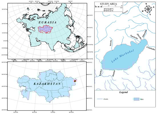
Figure 1.
Geographical location of Lake Markakol.
The southern shore of Lake Markakol is characterized by abundant vegetation, including small forested zones situated along the northern slopes of the adjacent mountain ridges. These forests are predominantly composed of coniferous species. At elevations exceeding 2000 m, subalpine meadows dominate the landscape, marked by dense grass cover and a diverse assemblage of flowering plants.
The objective of this study was to update the morphometric characteristics of Lake Markakol through the application of modern hydroacoustic instruments and advanced geospatial mapping techniques. Specifically, we aim to address the following research questions: (1) How has the morphometry of Lake Markakol changed since the last survey conducted over 60 years ago? (2) What new limnological insights can be gained from the updated bathymetry, particularly regarding sedimentation zones, mixing regimes, and thermal structure? (3) How can the resulting high-resolution data support further ecological and hydrological modeling efforts in this high-mountain lake system?
2. Materials and Methods
The morphometric characteristics were determined using classical methodologies commonly employed in hydrological studies of lakes [27,28,29,30,31]. A block diagram outlining the bathymetric survey procedure is provided in Figure 2.
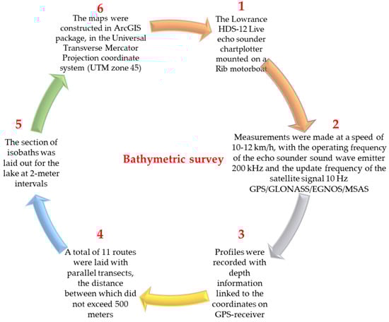
Figure 2.
Block diagram of the bathymetric survey.
This method of determining lake bathymetry requires direct field measurements and is both labor-intensive and costly. Alternative, more economical approaches exist for acquiring bathymetric data—such as generating digital elevation models (DEMs) from SRTM satellite imagery and applying the stepwise water level reduction (WRM) method to construct three-dimensional bathymetric maps based solely on DEM data [32,33]. However, the accuracy of such approaches does not meet the standards defined by the normative documentation of the Republic of Kazakhstan (RK), which requires a measurement precision of ±0.5 m for depths exceeding 20 m [29]. As a result, it was necessary to employ a more resource-intensive methodology involving instrumental field surveys, which provided significantly higher accuracy in bathymetric data acquisition.
The 1962 reference dataset was obtained using archival planimetric methods based on topographic field surveys and manual depth sounding performed along pre-defined transects. These early measurements were compiled into 1:50,000 scale bathymetric charts with 2 m contour intervals. The estimated horizontal resolution of the original survey was approximately 250–500 m, with vertical uncertainty ranging from ±1.0 to ±2.0 m, particularly in deeper zones where interpolation between sparse sounding lines introduced additional error. These limitations are acknowledged in the comparative analysis of old and modern datasets.
Depth measurements were recorded with a precision of 0.1 m, irrespective of depth. In shallow zones densely populated with aquatic vegetation, measurements were conducted manually using a hand lead line. The survey transect system was designed to ensure uniform spatial coverage across the entire lake. Field data collection was conducted over an 11-day period, ensuring adequate temporal and spatial coverage of the entire lake basin.
Depth data were collected using a calibrated single-beam echo sounder (Lowrance Elite FS 9), which was regularly verified against known depth markers and reference manual readings throughout the field campaign. Positional accuracy was ensured through integration with a GNSS receiver providing sub-meter horizontal accuracy. Calibration was conducted each survey day, using in-lake control points to adjust for temperature- and turbidity-related speed of sound variations in water.
Sounding data were processed using ReefMaster v1.6 software. Outlier detection was based on amplitude filtering and depth consistency checks within local neighborhoods of 5 × 5 points. Points deviating by more than ±1.5 standard deviations from the local mean, or showing abrupt vertical jumps (>0.8 m between adjacent fixes), were flagged and reviewed manually. The overall rejection rate of depth points was under 2.5%. The Root Mean Square Error (RMSE) of calibrated measurements, based on comparisons with ground-truth manual readings, was ±0.17 m (vertical).
The application of modern echo sounder profiling techniques, in combination with advanced geoinformation tools, facilitated the detailed identification of bottom relief features, increased the density and positional accuracy of sounding points, and substantially accelerated the overall survey process while enhancing data reliability. Based on the acquired data, a bathymetric map was constructed. The contour interval spacing was selected according to the observed variation in bottom elevation, ensuring that the principal morphological features of the lake bed were accurately represented.
To generate digital elevation models (DEMs), the collected depth data were treated as an irregular spatial dataset consisting of points with associated depth values. In this study, the rejection rate of data points unsuitable for model construction was minimal. Erroneous measurements—typically resulting from temporary echo sounder malfunctions—were excluded from the dataset.
Interpolation of the lakebed surface was performed using the Topo to Raster tool in ArcGIS 10.8, with a cell size of 10 m and smoothing factor set to default (2.0). The Topo to Raster method was selected based on its capacity to create hydrologically correct DEMs from irregularly spaced input data, enforcing flow continuity and depressionless topography. While kriging and spline-based methods were also tested during preprocessing, they produced artifacts near shoreline boundaries and lacked hydrological structure, which is crucial for volume and area computations. The choice of interpolation method aligns with geostatistical best practices for modeling water surfaces and terrain from dense echo sounder datasets [32].
The DEM construction area was restricted to the lake boundary, delineated through vectorization of Landsat satellite imagery. DEMs were developed using the ArcGIS software suite, based on the depth values obtained from the echo sounder surveys. Relief interpolation was performed using the Topo to Raster method, which is specifically designed to produce hydrologically correct digital elevation models. Outside the shoreline boundary, contour lines were refined manually in ArcGIS by drawing structural lines between key depth points to ensure an accurate isoline configuration. This manual refinement involved comparing automatically generated contours with the raw depth point dataset and adjusting lines to follow observed bathymetric gradients more closely, thereby removing minor interpolation artifacts and preserving the true geometry of bottom features in shallow and structurally complex areas. A three-dimensional representation of the lake bottom was generated using ArcScene 10.8 software [33,34].
To fulfill the objective of updating the morphometric characteristics of Lake Markakol, a comprehensive multi-stage methodology was implemented, as outlined in Figure 3 [29,30,31].
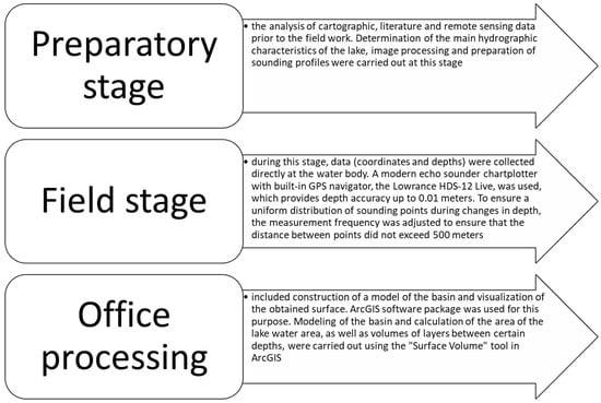
Figure 3.
Stages of the study.
The study was conducted in several stages, including preparatory activities, field measurements using modern instrumentation, and final data processing with specialized software. This integrated approach enabled a more accurate determination of the morphometric parameters of Lake Markakol. The methodology applied for morphometric analysis followed the procedures outlined in [35,36,37,38,39,40,41].
During the preparatory stage, relevant reference materials were collected, including a literature review, extraction of textual data, compilation of tabulated information, and the selection of figures for subsequent manual digitization and computer-based processing. To support the planning of fieldwork activities, available cartographic materials of the study area were also examined.
As part of the historical data review and systematization, a schematic map of Lake Markakol—originally compiled using data from 1962—was analyzed (Figure 4).
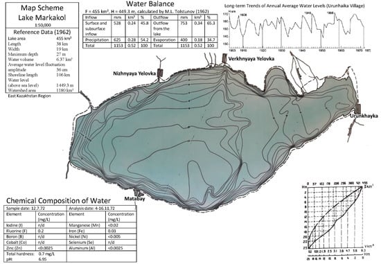
Figure 4.
Schematic map of Lake Markakol in 1962, scale 1:50,000. (n/d: not detected).
The schematic map of Lake Markakol, produced at a scale of 1:50,000, includes bathymetric data represented by 2 m contour intervals that illustrate the bottom relief of the lake (Figure 4). In addition to depth information, the map contains data on water chemistry and the temporal dynamics of mean annual water levels.
The peripheral area of the lake is traversed by a field road connecting the settlements of Urunhaika, Verkhnyaya Yelovka, and Matabai. The map also schematically represents the main tributaries feeding the lake, including the Tikhushka, Topolevka, and Yelovka rivers, as well as the outflowing Kalzhyr River. The deepest part of the lake is located in its southern sector, near the settlement of Matabai.
3. Results
3.1. Digitization and Creation of a Three-Dimensional Model of the Lake Based on Archival Data
To enable a comparative analysis between modern and archival datasets, the original bathymetric map of Lake Markakol from 1962 was digitized and subsequently used to generate a three-dimensional model of the lake. The digitization process involved two main stages. First, the paper map was scanned at a resolution of approximately 500 dpi, yielding a graphical accuracy of 0.1 mm, compared to the original map’s graphical accuracy of 0.2 mm. In the second stage, the resulting raster image was vectorized using ArcGIS software to produce a digital vector map.
Because the original schematic map lacked a coordinate grid, georeferencing was performed using identifiable situational features and the shoreline, applying the Universal Transverse Mercator (UTM) coordinate system, zone 45. The vectorization of the shoreline and isobaths was conducted using ArcMAP software. The resulting vector data were interpolated into a raster format using the Spatial Analyst Tools–Interpolation–Topo to Raster function, producing digital bathymetric map of the lake (Figure 5).
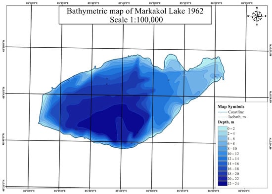
Figure 5.
Digitized bathymetric map of Lake Markakol compiled from data of 1962.
Landsat satellite imagery (30 m spatial resolution) and SRTM elevation data (30 m spatial resolution), obtained from the official USGS website (https://earthexplorer.usgs.gov/, last accessed on 8 July 2025), was used to construct a three-dimensional model and visualization of the lake and its surroundings. Using ArcScene software, a 3D model of Lake Markakol and the adjacent terrain was developed (only the most representative view is shown in Figure 6). This visualization was cross-checked with the interpreted shoreline from modern satellite imagery, revealing clear discrepancies along the northern shoreline. These discrepancies are most likely the result of inaccuracies in the coordinate referencing of the original map, as well as the schematic nature of the historical representation of hydrographic features.
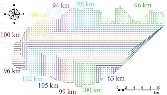
Figure 6.
Optimal transect chart for making depth measurements.
3.2. Chart of Transects for Depth Measurement
To optimize the transect system and improve the efficiency of depth measurements on the lake, a new methodology was implemented involving the development of a transect chart. This approach focused on designing optimized navigation routes to support systematic depth data collection. Global Positioning System (GPS) satellite navigation served as the primary positioning tool during the hydrographic survey. Transects were defined based on pre-planned project lines specifically tailored for hydrographic measurements. The planning process considered the following elements:
- Survey area boundaries: The shoreline of the lake was delineated using satellite imagery, which served as the reference boundary for transect design.
- Coordinate grid system: The WGS 1984 global coordinate system was adopted, with the option for conversion to the Universal Transverse Mercator (UTM) rectangular coordinate system, to align with the use of satellite-based geospatial data.
- Transect spacing: Given that the survey was conducted for scientific purposes, and in accordance with SP RK 1.02-101-2014 Kazakh National Code [27], reconnaissance and light hydrographic works were planned. In such works, depth measurements are typically performed along a sparse transect grid using simplified horizontal positioning techniques. Consequently, a spacing of 500 m between transects was selected for this study [28,29,30].
Operational parameters—including an average boat speed of up to 12 km/h and an 8 h working day—were also considered. Based on these constraints, the optimal daily survey distance was determined to be 96 km. Using the input data, the optimal navigation routes for depth measurement were designed in AutoCAD 2025 software (Figure 6), with Urunhaika designated as the base point.
Navigation points were distributed uniformly at 500 m spacing, producing 1780 points and a total planned route length of 1051 km. The points and lines were converted into KMZ format for direct upload to the echo sounder [42].
3.3. Field Works and Data Acquisition
A series of field hydrographic surveys was carried out to collect data on lake conditions, bottom topography, and the water surface. These data were subsequently used to generate a detailed bathymetric map and to determine key hydrometric parameters.
To facilitate navigation during field operations, the pre-designed measurement routes—configured as track lines—were uploaded to a mobile device, which served as an auxiliary navigation tool. The OfflineMaps application, equipped with pre-downloaded satellite imagery, was used to support real-time positioning based on the predefined navigation points and tracks (Figure 7).
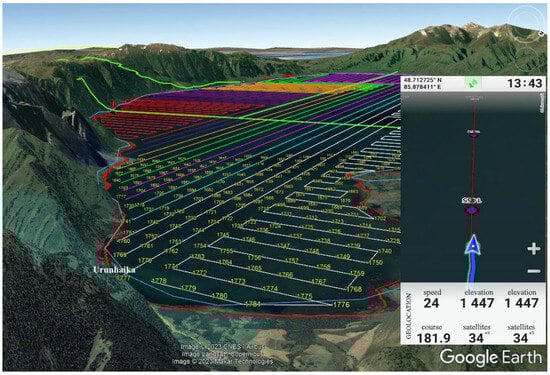
Figure 7.
Transect and point navigation using the OfflineMaps application.
- Bathymetric measurements were conducted to produce a detailed bathymetric map of the study area. In accordance with established depth measurement methodologies, the following types of measurements were performed [1,2,3]:
- Depth measurement using an echo sounder;
- Depth measurement using a rod or hand lead line;
- Depth measurement using a mechanical lead line equipped with a hydrometric weight and a graduated crane.
In this study, a modern echo sounder chartplotter—Lowrance HDS-12 Live—was employed to carry out the bathymetric survey. This device integrates advanced technologies that enable high-accuracy depth measurements in inland water bodies. The key technical specifications and features of the device are as follows:
- Display: SolarMax HD, 12-inch screen, 1280 × 800 resolution, multi-touch interface (Lowrance Electronics, Tulsa, Oklahoma, USA);
- Echo sounder: Active Imaging 3-in-1 with StructureScan 3D and LiveSight transducer support;
- Transducer: Active Imaging 3-in-1 included;
- Maximum depth range: 305 m (CHIRP); 91 m (DownScan and SideScan);
- Power supply: 12 VDC (operational range 10.8–17 VDC);
- GPS module: 16-channel, 10 Hz built-in GPS receiver;
- Mapping support: Compatible with Navionics and C-MAP;
- Memory capacity: 100 tracks, 3000 waypoints, 100 routes.
The SolarMax HD is equipped with a 3-in-1 Active Imaging transducer that supports CHIRP frequencies of 83/200 kHz, DownScan Imaging, and SideScan Imaging. It includes a 7.6 m transducer cable with a 9-pin connector and features an integrated temperature sensor. The device also offers a Temperature Graph function, which allows monitoring of water temperature variations with depth.
The transducer provides stable depth readings at speeds of up to 70 km/h, with an optimal speed of approximately 15 km/h for detailed structural visualization. In 2D CHIRP mode, the device operates with cone-shaped beams, yielding a scan area of 52° at 83 kHz and 22° at 200 kHz. For SideScan and DownScan modes, operating frequencies of 455 kHz and 800 kHz are used. The maximum scanning depth is 91 m at 455 kHz and 45 m at 800 kHz [43].
The chartplotter is equipped with an integrated GPS antenna operating as a 16-channel system with an update frequency of 10 Hz, providing real-time location updates at a rate of ten times per second. The system supports enhanced positioning accuracy via satellite-based augmentation systems such as WAAS, EGNOS, and MSAS. Additionally, the chartplotter includes built-in functionality for generating and managing waypoints, routes, and tracks. The device can store up to 3000 waypoints in its internal memory, each of which can be assigned a unique icon. It is also capable of recording and storing up to 100 tracks, with a maximum of 10,000 points per track. Moreover, up to 100 routes can be saved, offering significant flexibility for route planning and waypoint navigation [30,31,32].
Field operations were monitored daily by transferring raw data from the echo sounder recorder to ReefMaster v1 software. This software is specifically designed for the generation of bottom relief maps, the extraction and processing of sonar data points, the creation of three-dimensional bathymetric models, and the production of hydrographic mosaics [44]. ReefMaster enables visualization of the boat’s trajectory as recorded by the echo sounder, with each data point containing precise geographic coordinates and corresponding depth measurements.
The software supports the assignment of color palettes to individual points based on their measured depths, thereby enabling preliminary visualization of lake bathymetry during the initial phase of field data processing. ReefMaster serves as an effective tool for the analysis and visualization of hydrographic survey data, contributing to a more accurate and comprehensive representation of the lake bottom topography.
All data collected during field measurements were subsequently processed in the office using ReefMaster software. This processing phase involved the identification and elimination of significant errors in the raw dataset, resulting in a refined set of depth points with geographic coordinates referenced to the WGS 1984 coordinate system [44].
Independent validation and accuracy assessment: no direct in situ gauge measurements from 1962 were available for quantitative comparison. However, for the 2023 datasets, independent verification was performed at 12 fixed control points distributed across various depth ranges. Depth obtained from the echo sounder were compared with manual lead-line measurements, resulting in a mean absolute error (MAE) of 0.14 m and a root mean square error (RMSE) of 0.17 m. The shoreline position was independently validated against Sentinel-2 imagery (10 m resolution) from the survey period, showing positional deviations below 5 m. These statistics confirm the high reliability of the hydroacoustic dataset.
3.4. Desktop Work and Geostatistical Analysis
The creation of bathymetric data for Lake Markakol was conducted through a structured bathymetric survey process, involving the collection of depth (bathymetric) measurements across the study area. These measurements were obtained using specialized technical equipment, although manual methods were employed in specific cases. Following appropriate data processing, the results constituted a georeferenced dataset containing information on the spatial distribution of depths within the surveyed domain. Depending on the selected coordinate system, each depth value was represented as a triplet: either BLZ (geographic latitude, geographic longitude, depth) or XYZ (projected rectangular coordinates and depth). Such bathymetric data can be used for general mapping and analysis of bottom relief, as well as for applied tasks such as sediment accumulation studies, dredging control, and other engineering or environmental applications [45,46,47].
The bathymetric data were processed and visualized using the ArcGIS software suite, which provides a robust and scalable platform for managing geospatial information. ArcGIS supports a wide variety of data types and offers powerful tools for visualization, spatial analysis, and data management, adding significant value to bathymetric datasets. Its intuitive user interface and advanced geoprocessing capabilities make it well-suited for hydrographic analysis. Additionally, its customizable metadata functionalities streamline data access and facilitate the generation of tailored bathymetric surfaces through targeted data filtering and prioritization. Real-time data accessibility also minimizes redundancy and enhances workflow efficiency [45,46,47].
The GIS-based process of generating bathymetric data for Lake Markakol included the following tasks:
- Delineation and vectorization of the lake shoreline;
- Construction of the bathymetric map;
- Geostatistical analysis of the bathymetric data;
- Determination of bathygraphic curve coordinates;
- Calculation of the lake’s morphometric characteristics.
This workflow supports the systematic application of GIS technologies for the acquisition and analysis of lakebed depth and morphology, which is essential for producing an accurate representation of the lake’s structural and volumetric properties [48].
Following the shoreline interpretation process, key hydrometric parameters of the lake were determined: the shoreline length was measured at 103.56 km, and the total water surface area was calculated as 455,365 km2.
To construct the bathymetric map of Lake Markakol, depth measurement points were imported into the ArcMap workspace. A total of approximately 1.36 million depth points, each with associated geographic coordinates, were uploaded from the echo sounder recorder. These depth data were then combined with the polygon layer representing the delineated shoreline to generate an interpolated surface [48]. The Topo to Raster tool was employed for this purpose, as it is specifically designed to produce hydrologically correct Digital Elevation Models (DEMs). This process yielded the bathymetric dataset used for further analysis.
Subsequently, isobaths were generated from the processed bathymetric data, and a detailed bathymetric map of Lake Markakol was produced using the ArcToolBox suite in ArcGIS [49,50,51,52]. To generate a three-dimensional representation, a model of the lake and its surrounding terrain was visualized using ArcScene software (Figures S3–S5 in Supplementary Materials).
A geostatistical analysis of the bathymetric dataset was conducted to characterize the spatial variability of depths and to ensure optimal interpolation accuracy. The input dataset comprised 1,321,287 depth measurements obtained from the calibrated single-beam echo sounder, combined with shoreline points derived from high-resolution satellite imagery (Sentinel-2). The spatial distribution of these input points presented in Figure 8, which highlights the uniform coverage of transects and denser sampling near the shoreline to capture abrupt depth gradients.
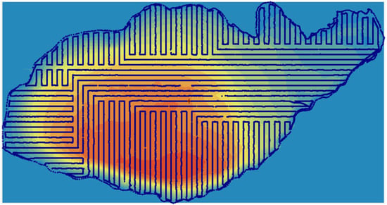
Figure 8.
Spatial distribution of input depth points.
An anisotropic spherical variogram model was selected, reflecting the elongated morphology of Lake Markakol. Cross-validation metrics are presented in Figure 9, demonstrating the high reliability of the kriging interpolation: mean prediction error = 0.002 m, RMSE = 0.047 m, and regression slope between predicted and observed depth = 0.99998. These results indicate negligible bias and excellent predictive performance.
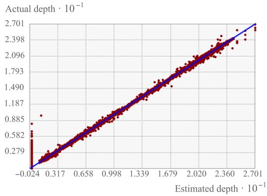
Figure 9.
Cross-validation analysis.
3.5. Morphometric Change Analysis
The determination of bathygraphic curve coordinates was based on bathymetric and topographic map data, which represent the bottom relief of the water body through isobaths, contour lines, or depth markers with the necessary level of precision and detail. To calculate the water volume and surface area of Lake Markakol, the following steps were performed:
- Conversion of the completed isobaths into polygon objects;
- Assignment of depth values to each polygon layer;
- Calculation of water volume and surface area.
The resulting estimates of water volume and surface area are presented in Table 1. Based on these data, bathygraphic and area–capacity curves were constructed to characterize the lake’s morphometry. To facilitate visual comparison with archival data from 1962, a comparative analysis was carried out (Figure 10). The graph clearly indicates that the lake’s surface area has remained virtually unchanged at approximately 455 km2, whereas the water volume has increased by 0.3 km3.

Table 1.
Water surface area and water mass volume.
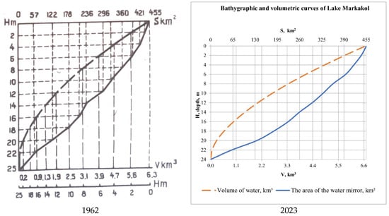
Figure 10.
Bathygraphic and area capacity curves of Lake Markakol.
The determination of Lake Markakol’s morphometric characteristics was conducted following established limnological methodologies. In limnology, water body morphometry refers to a set of quantitative techniques used to assess the size and geometric configuration of aquatic systems [32]. The primary parameters typically evaluated include shoreline length, surface area, water body length, maximum width, maximum depth, and total water volume.
AutoCAD software was used to determine the length and width of the lake. The lake length (L) was defined as the shortest distance between the two most distant points along the shoreline, measured along the water surface (points A and B in Figure 11). The maximum width was defined as the longest line perpendicular to this length. To determine it, several perpendicular transects were drawn across the lake, connecting opposing shores. The line representing the longest transverse section perpendicular to the A–B axis was considered the maximum width of the water body.
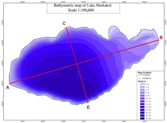
Figure 11.
Determining the length and width of the lake.
In addition, longitudinal profiles were generated along the length axis A–B and the width axis C–E (Figure 12). These profiles clearly illustrate the lake bottom relief as derived from both the 1962 archival data (blue line) and the 2023 survey data (red line), allowing for a direct comparison of historical and updated bathymetric conditions (Figure 12).
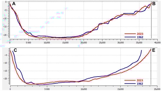
Figure 12.
Longitudinal profiles along the lake length (A–B) and width (C–E) axes based on 1962 and 2023 bathymetric data.
Based on the results of this study, the morphometric characteristics of Lake Markakol were updated, and a comparative table was compiled to present the newly obtained values alongside historical data from previous years (Table 2).
Table 2.
Morphometric characteristics of Lake Markakol in 1962 and 2023 with uncertainty bounds for 2023 measurements.
The comparative analysis revealed no significant changes in the water surface area, length, or width of Lake Markakol. However, the maximum depth was found to be lower than the value reported in the 1962 data: while the earlier survey indicated a maximum depth of 27 m, the present study—using a more accurate echo sounder—recorded a depth of 24.14 m. This discrepancy is likely due to overestimation in the earlier measurements, which were performed using a traditional lead line that is prone to deviation from the vertical axis during sounding operations [34,53,54]. Additionally, an increase in the estimated water volume of approximately 0.3 km3 was observed, attributed to the use of high-precision echo-sounding equipment and a denser, more accurate dataset of depth measurements.
These results support a more accurate determination of the lake’s morphometric parameters and emphasize the importance of regularly updating bathymetric data using modern technologies. Such updates are essential for effective monitoring of lake conditions and for supporting data-driven decision-making in water resource management. Overall, the updated morphometric characteristics of Lake Markakol exhibit only minor deviations from historical values, most of which are likely attributable to limitations in the precision of earlier measurement techniques.
4. Discussion
4.1. Comparison to Historical Data
Our updated morphometric survey shows that Lake Markakol has remined remarkably stable in shape and size over the past six decades. The surface area, length, and width have changed only slightly, suggesting that the lake basin itself is largely unchanged. The main difference lies in the maximum depth: recorded in 2023 (24.14 ± 0.17 m) is notably lower than the 27 m reported in 1962. This difference is probably not due to actual deepening or shallowing, but to the limitations of the earlier measurements, which can easily overestimate depth because of line angle drift and less precise positioning.
Interestingly, our calculated water volume is slightly higher than the 1962 figure (6.667 ± 0.025 km3 versus 6.37 km3). This reflects improved spatial resolution and denser transect coverage used in the present survey. Similar corrections to earlier depth and volume estimates have been reported in recent studies using advanced sonar or combined remote sensing-hydroacoustic approaches, including multi-source bathymetry fusion from Sentinel-2 and ICESat-2 [14], high-resolution bathymetric modeling for alpine lakes in Central Asia [15], and updated sonar-based mapping of Lake Chandratal in the western Himalayas [55], which collectively demonstrate that improved resolution can reduce systematic bias in historical datasets.
4.2. Methodological Limitations
While today’s hydroacoustic mapping offers much greater accuracy and shoreline detail than traditional methods, it is important to acknowledge its limits. Our work provides just a single temporal snapshot of the lake, so it cannot capture seasonal or year-to-year changes in depth and volume. Even with high-frequency acoustic systems, shallow areas with dense aquatic vegetation still require manual lead-line measurements to confirm depth.
Sediment composition also plays a role. Much of Lake Markakol’s bottom is covered by soft sapropel, which can absorb or scatter sonar pulses. This means the measured depth reflects the water-sediment interface rather than the hard geological floor. Over time, as sapropel accumulates, this “soft” surface rises, effectively reducing the water column depth and contributing to gradual basin infilling. This limitations has also been noted in recent bathymetric analysis of eutrophic lakes, where unconsolidated organic layers caused systematic underestimation of true geological depth [56].
4.3. Ecological Implications
Sediment sapling revealed a marked shift from the rocky and silty bottoms described in past surveys to today’s thick layers of dark sapropel in deeper zones, with brown organic-rich sediments closer to shore. This points to an increase in organic matter deposition, most likely linked to higher nutrient inputs. Such build-up changes the benthic habitat, affects nutrient cycling, and, over decades, reduces the lake’s storage capacity.
Comparable changes have been seen elsewhere—for example, in Lakes Hawassa and Cheleleka in Ethiopia—where shifts in sediment composition have been tied to watershed land use change and increased nutrient runoff and possible climate-related changes in water inflow and sediment transport [38]. Similar processes have been observed in recent assessments of alpine lakes in the Tien-Shan and Himalayas, where land-cover change and intensified grazing contributed to rapid sapropel accumulation [57,58].
4.4. Potential Drivers of Observed Changes
It is likely that the patterns we see in Markakol result from a mix of human activities and natural processes. Increased livestock grazing in the catchment can lead to more nutrient-rich runoff, stimulating algae and plant growth, which in turn accelerates organic sedimentation. Changes in land use—such as the expansion of grazing lands or reductions in forest cover—can also increase erosion and particle inflow.
On the climate side, shifts in precipitation patterns or the timing of snowmelt could alter how and when sediments enter the lake. These combined pressures may subtly reshape the lake’s thermal structure, affect mixing patterns, and influence long-term water quality [59,60,61,62].
All of this underscores the need for regular, integrated monitoring that combines bathymetric mapping, sediment analysis, and water quality studies. Such a program would make it possible to distinguish between slow, natural basin evolution and changes driven by human activity—an essential step for protecting high-mountain lakes like Markakol.
Recent methodological frameworks for integrated lake monitoring [63] suggest combining annual hydroacoustic surveys with high-frequency satellite-based water-level tracking and periodic sediment core analysis, which could be directly applied to Lake Markakol to improve long-term conservation strategies.
Such alterations in lake systems may manifest as changes in surface area, water volume, or storage capacity, as well as in water quality, driven by regional dynamics, basin morphology, and geological factors. Therefore, the study of lake morphometry is essential not only for understanding spatial changes in shape and size but also for evaluating hydrological and limnological characteristics over time [64,65,66].
5. Conclusions
This study set out to update and refine the morphometric characteristics of Lake Markakol using high-resolution hydrographic survey techniques and advanced geospatial analysis. The results demonstrate that despite the influence of various natural and physiographic factors, the lake basin has exhibited remarkable morphological stability over the past six decades. We evaluated changes relative to the 1962 dataset and generated a validated, high-density bathymetric dataset for future research and management.
Our revised analysis confirms that the lake’s surface area (455,365 ± 0.005 km2), maximum length (38,304 ± 0.002 km), and maximum width (19,138 ± 0.002 km) remained stable, while the maximum depth is below historical estimates (24.14 ± 0.17 m versus 27 m), mainly due to methodological improvements. The recalculated volume (6.667 ± 0.025 km3) is slightly higher, reflecting improved spatial coverage and resolution. These results are consistent with similar corrections obtained in other studies of high-altitude lakes, where modern sonar mapping has made it possible to refine earlier measurements.
Despite these advances, several limitations must be acknowledged. The survey represents a single temporal snapshot, preventing assessment of seasonal or interannual variability; residual uncertainties remain in vegetation-rich shallow zones; and the bathymetry reflects the sediment–water interface rather than the hard geological floor, meaning that long-term siltation processes may progressively alter measured depths.
The hydrometric survey, conducted using modern echo-sounding and geospatial tools, enabled the generation of a detailed bathymetric map and a digital elevation model (DEM) of the lakebed. Looking forward, future work should integrate satellite altimetry (e.g., ICESat-2, Sentinel-3) with in situ sonar acquisition and robust geostatistical interpolation to the derivation of uncertainty-quantified morphometric parameters. This methodology can be applied to other remote or data-scarce alpine lakes worldwide, enabling comparable accuracy gains.
Although this study was exploratory in nature, the resulting bathymetric model constitutes a valuable foundation for future limnological and ecological research. In particular, the model is directly applicable to ongoing studies on micro- and macroplastic pollution in the aquatic environment, as bathymetry significantly influences the spatial distribution and accumulation of such contaminants.
Moreover, the high-resolution bathymetric dataset produced here can support the development of a digital ecological passport for Lake Markakol—an integrated geospatial tool that can inform conservation planning, water resource management, and recreational use assessments. The integration of morphometric data into such tools will enhance the capacity of stakeholders to monitor, protect, and sustainably manage this ecologically significant high-mountain lake.
Supplementary Materials
The following supporting information can be downloaded at https://www.mdpi.com/article/10.3390/hydrology12090228/s1. Figure S1. Model of Lake Markakol according to 1962 data on the background of the current satellite image. Figure S2. Echo sounder chartplotter Lowrance HDS-12 Live. Figure S3. View of primary data in ReefMaster software. Figure S4. Adding satellite images of Lake Markakol to ArcMap workspace. Figure S5. Bathymetric data of Lake Markakol. Figure S6. Bathymetric map of Lake Markakol. Figure S7. Model of Lake Markakol.
Author Contributions
Conceptualization, A.Z. (Askhat Zhadi) and A.M.; methodology, A.Z. (Askhat Zhadi) and S.Z.; software, A.Z. (Askhat Zhadi), S.Z. and Z.R.; validation, S.Z., A.Z. (Askhat Zhadi), and A.Z. (Aidar Zhumalipov); formal analysis, A.Z. (Aidar Zhumalipov); investigation, A.Z. (Askhat Zhadi); resources, S.Z.; data curation, A.Z. (Aidar Zhumalipov); writing—original draft preparation, A.Z. (Askhat Zhadi), L.I., A.M., M.-E.R.-C. and J.R.-I.; writing—review and editing, A.Z. (Askhat Zhadi), M.-E.R.-C. and J.R.-I.; visualization, A.Z. (Askhat Zhadi), B.S. and Z.R.; supervision, A.M. and J.R.-I.; project administration, A.M.; funding acquisition, M.-E.R.-C. and J.R.-I. All authors have read and agreed to the published version of the manuscript.
Funding
This research received no external funding.
Data Availability Statement
The original contributions presented in this study are included in the article. Further inquiries can be directed to the corresponding author.
Acknowledgments
The authors acknowledge Erasmus + CBHE project “Land management, Envi-ronment and SoLId-WastE: inside education and business in Central Asia” (LESLIE), project number ERASMUS-EDU-2023-CBHE No. 101129032, for its cooperation in the dissemination of this work.
Conflicts of Interest
The authors declare no conflicts of interest.
References
- Naumenko, M.A. A new estimation of morphometric characteristics of Lake Onega. Rep. Acad. Sci. 2000, 370, 393–396. [Google Scholar]
- Zlinsky, A.; Molnar, G. Georeferencing the First Bathymetric Maps of Lake Balaton, Hungary. Acta Geod. Geoph. Hung. 2009, 44, 79–94. [Google Scholar] [CrossRef][Green Version]
- Vereshchagin, G.Y. Methods of morphometric characteristics of lakes. In Proceedings of the Olonets Scientific Expedition; Book 2, Russian Hydrological Institute: Leningrad, Russia, 1930; Volume 1, p. 106. [Google Scholar][Green Version]
- Li, Z.; Zhu, C.; Gold, C. Digital Terrain Modeling: Principles and Methodology, 1st ed.; CRC Press: Boca Raton, FL, USA, 2004. [Google Scholar] [CrossRef]
- Caballero, I.; Stumpf, R.P. On the use of Sentinel-2 satellites and lidar surveys for the change detection of shallow bathymetry: The case study of North Carolina inlets. Coast. Eng. 2021, 169, 103936. [Google Scholar] [CrossRef]
- Hossen, H.; Khairy, M.; Ghaly, S.; Scozzari, A.; Negm, A.; Elsahabi, M. Bathymetric and Capacity Relationships Based on Sentinel-3 Mission Data for Aswan High Dam Lake, Egypt. Water 2022, 14, 711. [Google Scholar] [CrossRef]
- Sundt, H.; Alfredsen, K.; Museth, J.; Forseth, T. Combining green LiDAR bathymetry, aerial images and telemetry data to derive mesoscale habitat characteristics for European grayling and brown trout in a Norwegian river. Hydrobiologia 2022, 849, 509–525. [Google Scholar] [CrossRef]
- Kaya, Y.; Balik Sanli, F.; Abdikan, S. Refinement of ICESat-2 derived inland water surface levels with the TG20 local geoid model: In the case of Türkiye lakes. Phys. Chem. Earth Parts A/B/C 2025, 139, 103900. [Google Scholar] [CrossRef]
- Xu, N.; Zheng, H.; Ma, Y.; Yang, J.; Liu, X.; Wang, X. Global Estimation and Assessment of Monthly Lake/Reservoir Water Level Changes Using ICESat-2 ATL13 Products. Remote Sens. 2021, 13, 2744. [Google Scholar] [CrossRef]
- Database Update: NH Bathymetry—Lakes. Available online: https://www.nhgeodata.unh.edu/search?q=bathymetry (accessed on 15 August 2025).
- Guan, J.; Zhang, H.; Han, T.; Cao, W.; Wang, J.; Li, D. High-Resolution Mapping of Shallow Water Bathymetry Based on the Scale-Invariant Effect Using Sentinel-2 and GF-1 Satellite Remote Sensing Data. Remote Sens. 2025, 17, 640. [Google Scholar] [CrossRef]
- Li, Z.; Peng, Z.; Zhang, Z.; Chu, Y.; Xu, C.; Yao, S.; Garcia-Fernandez, A.; Zhu, X.; Yue, Y.; Levers, A.; et al. Exploring modern bathymetry: A comprehensive review of data acquisition devices, model accuracy, and interpolation techniques for enhanced underwater mapping. Front. Mar. Sci. Sec. Ocean Obs. 2023, 10, 1178845. [Google Scholar] [CrossRef]
- Li, J.; Dong, Z.; Chen, L.; Tang, Q.; Hao, J.; Zhang, Y. Multi-Temporal Image Fusion-Based Shallow-Water Bathymetry Inversion Method Using Active and Passive Satellite Remote Sensing Data. Remote Sens. 2025, 17, 265. [Google Scholar] [CrossRef]
- Seafloor Mapping. Available online: https://www.ncei.noaa.gov/products/seafloor-mapping?utm_source=chatgpt.com (accessed on 15 August 2025).
- Xie, C.; Chen, P.; Zhang, S.; Huang, H. Nearshore Bathymetry from ICESat-2 LiDAR and Sentinel-2 Imagery Datasets Using Physics-Informed CNN. Remote Sens. 2024, 16, 511. [Google Scholar] [CrossRef]
- Yeu, Y.; Yee, J.-J.; Yun, H.S.; Kim, K.B. Evaluation of the Accuracy of Bathymetry on the Nearshore Coastlines of Western Korea from Satellite Altimetry, Multi-Beam, and Airborne Bathymetric LiDAR. Sensors 2018, 18, 2926. [Google Scholar] [CrossRef]
- Kaya, Y. Evaluation of ICESat-2 Laser Altimetry for Inland Water Level Monitoring: A Case Study of Canadian Lakes. Water 2025, 17, 1098. [Google Scholar] [CrossRef]
- Great Lakes Bathymetry. Available online: https://www.ncei.noaa.gov/products/great-lakes-bathymetry?utm_source=chatgpt.com (accessed on 28 August 2025).
- Khare, N.; Chaturvedi, S.K.; Saraswat, R.; Srivastava, R.; Raina, R.; Wanganeo, A. Some morphometric characteristics of Priyadarshini water body at Schirmacher Oasis, Central Dronning Maud Land, Antartica with special reference to its bathymetry. Indian J. Mar. Sci. 2008, 37, 438. [Google Scholar]
- Basos, N.; Martins, F.; Rodrigues, J. Bathymetry interpolation for hydrodynamic modelling. Lisboa 2014, 24, 25–26. [Google Scholar]
- Nishikanth, C.V.; Vasudevan, S.; Balamurugan, P.; Selvaganapathi, R. Morphometry Characteristics Delineation and Bathymetry Mapping of Lake Dal, Kashmir valley, India using Geospatial Techniques. Int. J. Multidiscip. 2018, 3, 216–220. [Google Scholar] [CrossRef]
- Sherstyankin, P.P.; Alekseev, S.P.; Abramov, A.M.; Stavrov, K.G.; De Batist, M.; Hus, R.; Canals, M.; Casamor, J.L. Computer-based bathymetric map of Lake Baikal. Dokl. Earth Sci. 2006, 408, 564–569. [Google Scholar] [CrossRef]
- Astashin, A.; Badin, M.; Vatina, O.; Podkovyrina, V.; Il’ichyova, E. Morphometric characteristics of the Krasnyj Klyuch lake Complex (Republic of Bashkortostan, Russia). Water Resour. Aquat. Ecosyst. 2023, 431, 04005. [Google Scholar] [CrossRef]
- Rout, S.V.; Sivaprakasam, S.; Krishna, K. Lake Bathymetry Survey and Morphometric Characteristics of High Altitude Lake the Chandratal in Western Himalaya. J. Crit. Rev. 2021, 7, 4615–4625. Available online: https://www.researchgate.net/publication/350276417 (accessed on 28 August 2025).
- Tursunov, E.A.; Madibekov, A.S.; Ranova, S.U.; Galaeva, A.V. Modern bathygraphic characteristics of Kapshagai reservoir. Sci. J. “Hydrometeorol. Ecol.” Almaty 2014, 2, 105–110. [Google Scholar]
- Tursunov, E.A.; Madibekov, A.S.; Kulebaev, K.M. Modern morphometric characteristics of Lake Balkhash. In Scientific Notes of the Russian State Hydrometeorological University; special issue dedicated to the 80th anniversary of Prof. Dr. Doganovsky A.M.; RGGMU Press: Saints-Peterburg, Russia, 2014; pp. 43–48. (In Russian) [Google Scholar]
- SP RK 1.02-101-2014 Engineering-geodetic surveys for constructionBasic provisions. Committee for Construction, Housing and Utilities, and Land Resources Management, Ministry of National Economy of the Republic of Kazakhstan. Astana, Kazakhstan, 2015. (In Russian). Available online: https://igis.kz/images/snip/ntd-geodez-izyskaniya/sp-rk-1.02-101-2014-inzh-geodezich-izyskaniya-dlya-stroitelstva-osnovnye-polozheniya.pdf (accessed on 28 August 2025).
- Bykov, V.D.; Vasiliev, A.V. Hydrometry; Publishing Hydrometeoizdat: Leningrad, Russia, 1972; p. 447. (In Russian) [Google Scholar]
- Samokhin, A.A.; Soloviyev, N.N.; Doganovsky, A.M. Practicum on Hydrology; Hydrometeoizdat: Leningrad, Russia, 1980; p. 296. (In Russian) [Google Scholar]
- SP RK 1.02-105-2014 Engineering Surveys for Construction. Basic Provisions. (with Amendments and Additions from 02.02.2024). Available online: https://online.zakon.kz/Document/?doc_id=31848779 (accessed on 9 February 2024).
- SP RK 1.02-101-2014 Engineering-Geodetic Surveys for Construction. Basic Provisions. Available online: https://online.zakon.kz/Document/?doc_id=38117869 (accessed on 1 February 2024).
- SN RK 1.03-03-2013 Geodetic Works in Construction. State Regulations in the Field of Architecture, Urban Planning and Construction. Construction Norms of the Republic of Kazakhstan. Ministry of National Economy of the Republic of Kazakhstan. Date of Introduction—2015-07-01. Available online: https://online.zakon.kz/Document/?doc_id=34849777 (accessed on 9 February 2024).
- Azizian, A.; Shokoohi, A. Investigation of the Effects of DEM Creation Methods on the Performance of a Semidistributed Model: TOPMODEL. J. Hydrol. Eng. 2015, 20, 05015005. [Google Scholar] [CrossRef]
- Zhu, S.; Liu, B.; Wan, W.; Xie, H.; Fang, Y.; Chen, X.; Li, H.; Fang, W.; Zhang, G.; Tao, M.; et al. A new digital lake bathymetry model using the step-wise water recession method to generate 3D lake bathymetric maps based on DEMs. Water 2019, 11, 2419. [Google Scholar] [CrossRef]
- Xiao, Y.; Wang, G.; Zhao, H.; Wang, J.; Qiao, B. Estimation of Lake Storage Based on the Surrounding Topography around the Lake from the SRTM DEM. Water 2023, 15, 1015. [Google Scholar] [CrossRef]
- Bogoslovsky, B. Limnology (in Russian: Ozerovedenie); Moscow State University Publishing House: Moscow, Russia, 1960; p. 335. [Google Scholar]
- Kunz, M.; Skowron, R.; Skowroński, S. Morphometry Changes of Lake Ostrowskie (the Gniezno Lakeland) on the Basis of Cartographic, Remote Sensing and Geodetic Surveying. Limnol. Rev. 2010, 10, 77–85. [Google Scholar] [CrossRef]
- Abebe, Y.; Bitew, M.; Ayenew, T.; Alo, C.; Cherinet, A.; Dadi, M. Morphometric Change Detection of Lake Hawassa in the Ethiopian Rift Valley. Water 2018, 10, 625. [Google Scholar] [CrossRef]
- Perivolioti, T.-M.; Mouratidis, A.; Terzopoulos, D.; Kalaitzis, P.; Ampatzidis, D.; Tušer, M.; Frouzova, J.; Bobori, D. Production, Validation and Morphometric Analysis of a Digital Terrain Model for Lake Trichonis Using Geospatial Technologies and Hydroacoustics. ISPRS Int. J. Geo-Inf. 2021, 10, 91. [Google Scholar] [CrossRef]
- Choiński, A.; Zieliński, A. Transformation of the Morphometry of Lake Osieckie—Largest Lake in the Holy Cross Region. Limnol. Rev. 2021, 21, 181–187. [Google Scholar] [CrossRef]
- Šakurova, I.; Kondrat, V.; Baltranaitė, E.; Vasiliauskienė, E.; Kelpšaitė-Rimkienė, L. Assessment of Coastal Morphology on the South-Eastern Baltic Sea Coast: The Case of Lithuania. Water 2023, 15, 79. [Google Scholar] [CrossRef]
- Trimble® Business Center Office Software Is Ideal for Processing and Analyzing GNSS and Terrestrial (Total Station and Level) Survey Data Ecorded in the Field, and Exporting It to a Design Package. Available online: https://mytrimbleprotected.com/knowledge/docushare/retrieve?handle=File-503698 (accessed on 9 February 2024).
- LOWRANCE HDS-12 Live User Manual. Available online: https://www.manua.ls/lowrance/hds-live-12/manual?p=2 (accessed on 2 February 2024).
- ReefMaster User Manual v1.6; Copyright © 2014; ReefMaster Software Limited: Chichester, UK, 2014; p. 210.
- Michael, L. Getting to Know Arcgis Desktop/Law Michael, 3; Esri Press: New York, NY, USA, 2012; p. 856. [Google Scholar]
- Maribeth, P. Mastering ArcGIS/Price Maribeth. 7; McGraw-Hill Education: New York, NY, USA, 2015; p. 624. [Google Scholar]
- Michael, L. Getting to Know ArcGIS® Pro/Law Michael, Collins Amy. 3; Esri Press: New York, NY, USA, 2016; p. 450. [Google Scholar]
- Yan, Y.; Xiao, F.; Du, Y. Construction of lake bathymetry from MODIS satellite data and GIS from 2003 to 2011. Chin. J. Oceanol. Limnol. 2014, 32, 720–731. [Google Scholar] [CrossRef]
- GKINP (GNTA)-08-003-07 Basic Provisions on Creation and Updating of Topographic Maps at Scales 1:10 000, 1:25 000, 1:50 000, 1:100 000, 1:200 000, 1:500 000, 1:1 000 000. Agency of the Republic of Kazakhstan for Land Resources Management. Geodesic, Cartographic Instructions Norms and Rules. Approved by the Order of the Agency of the Republic of Kazakhstan for Land Resources Management Dated December 25, 2007, No. 200-P. Available online: https://online.zakon.kz/Document/?doc_id=32757121&show_di=1 (accessed on 2 February 2024).
- GKINP (GNTA)-02-028-09 Instruction on Topographic Survey at Scales of 1:5,000, 1:2,000, 1:1,000, 1:500. Agency of the Republic of Kazakhstan for Land Resources Management. Geodesic, Cartographic Instructions Norms and Rules. Astana 2009. Approved by the Order of the Agency of the Republic of Kazakhstan for Land Resources Management Dated December 15, 2009, No. 222-P. Available online: https://online.zakon.kz/Document/?doc_id=32904792&pos=4;-49#pos=4;-49 (accessed on 28 August 2025).
- Conditional Signs for Topographic Plans of Scale 1:5000, 1:2000, 1:1000, 1:500, GUGK ((Main Directorate of Geodesy and Cartography), 1986. Available online: https://rkc56.ru/documents/762 (accessed on 28 August 2025).
- Instruction on Topographic Survey in Scales 1:5000–1:500, Edition 2009. Available online: https://online.zakon.kz/Document/?doc_id=32904792 (accessed on 2 February 2024).
- Walther, M.; Kamp, U.; Nandintsetseg, N.-O.; Dashtseren, A.; Temujin, K. Glacial Lakes of Mongolia. Geographies 2024, 4, 21–39. [Google Scholar] [CrossRef]
- Drakopoulou, P.; Panagiotopoulos, I.P.; de Michele, M.; Kapsimalis, V.; Raucoules, D.; Foumelis, M.; Morfis, I.; Livanos, I.; Sakellariou, D.; Vandarakis, D. Cross-Comparison of the “BathySent” Coastal Bathymetry to Sonar Measurements and Ratio Model Technique: Pilot Sites in the Aegean Sea (Greece). Water 2023, 15, 3168. [Google Scholar] [CrossRef]
- Rout, S.P.; Vasudevan, S.; Balamurugan, P. Assessment of textural characteristics and magnetic susceptibility to understand the sedimentation environment of the Chandratal Lake, Spiti Valley, Himachal Pradesh, India. Solid State Technol. 2021, 64, 2450–2468. [Google Scholar]
- Kowalczewska-Madura, K.; Dunalska, J.A.; Kutyła, S.; Kobus, S. Bottom sediments as an indicator of the restoration potential of lakes—A case study of a small, shallow lake under significant tourism pressure. Sci. Rep. 2024, 14, 13438. [Google Scholar] [CrossRef] [PubMed]
- Jia, X.; Huang, T.; Chen, M.; Han, N.; Liu, Y.; Chen, S.; Zhang, X. Distribution of Grazing Paths and Their Influence on Mountain Vegetation in the Traditional Grazing Area of the Tien-Shan Mountains. Remote Sens. 2023, 15, 3163. [Google Scholar] [CrossRef]
- Chen, F.; Zhang, M.; Guo, H.; Allen, S.; Kargel, J.S.; Haritashya, U.K.; Watson, C.S. Annual 30 m dataset for glacial lakes in High Mountain Asia from 2008 to 2017. Earth Syst. Sci. Data 2021, 13, 741–766. [Google Scholar] [CrossRef]
- Rakybaeva, A.A.; Dzhantasova, A.S.; Baimukanov, M.T. Towards assessment of the current state of zooplankton of Lake Markakol. Bull. KazNU Biol. Ser. Almaty 2011, 4, 98–102. [Google Scholar]
- Unified ecological Internet resource of the Ministry of Ecology, Geology and Natural Resources of the RK. National Reports of the Convention on Biodiversity Conservation. Fourth National Report of the Republic of Kazakhstan on Biological Diversity. 2008, p. 110. Available online: https://ecogosfond.kz/orhusskaja-konvencija/dostup-k-jekologicheskoj-informacii/jelektronnaja-baza-normativno-pravovyh-aktov-v-oblasti-ohrany-okruzhajushhej-sredy-i-prirodopolzovanija-jekoinfopravo/ (accessed on 28 August 2025).
- Proceedings of the Institute of Hydrobiology and Ecology. Volume II State of the Hydrobionts of Water Bodies of Specially Protected Natural Territories of Republican Importance of East Kazakhstan and Almaty Oblasts of Kazakhstan (Information-Analytical Manual). Part 2. Markakol State Nature Reserve; Institute of Hydrobiology and Ecology Publishing house: Almaty, Kazakhstan, 2017; p. 55. (In Russian) [Google Scholar]
- Baimukanov, M.T. History of fishing on Lake Markakol, problems of maturation of fish resources, fish gene pool and ways to solve them. In Proceedings of Markakol Reserve; Part 2; Institute of Hydrobiology and Ecology Publishing House: Ust-Kamenogorsk, Kazakhstan, 2009; Volume 1, pp. 90–101. [Google Scholar]
- Marcé, R.; George, G.; Buscarinu, P.; Deidda, M.; Dunalska, J.; Eyto, E.; Flaim, G.; Grossart, H.-P.; Istvanovics, V.; Lenhardt, M.; et al. Automatic High Frequency Monitoring for Improved Lake and Reservoir Management. Environ. Sci. Technol. 2016, 50, 10780–10794. [Google Scholar] [CrossRef] [PubMed]
- Hakanson, L. A Manual of Lake Morphometry; Springer: Berlin/Heidelberg, Germany, 1981; p. 477. [Google Scholar]
- Sandwell, D.T.; Smith, W.H. Bathymetric estimation. In Satellite Altimetry and Earth Sciences: A Handbook of Techniques and Applications; Fu, L.-L., Cazenave, A., Eds.; Academic Press: San Diego, CA, USA, 2000; pp. 441–457. [Google Scholar]
- Schäfer, A.E.; Marchett, C.A.; Schuh, S.M.; Ahlert, S.; Lanzer, R.M. Morphological characterization of eighteen lakes of the north and middle coast of Rio Grande do Sul, Brazil. Acta Limnol. Bras. 2014, 26, 199–214. [Google Scholar] [CrossRef][Green Version]
Disclaimer/Publisher’s Note: The statements, opinions and data contained in all publications are solely those of the individual author(s) and contributor(s) and not of MDPI and/or the editor(s). MDPI and/or the editor(s) disclaim responsibility for any injury to people or property resulting from any ideas, methods, instructions or products referred to in the content. |
© 2025 by the authors. Licensee MDPI, Basel, Switzerland. This article is an open access article distributed under the terms and conditions of the Creative Commons Attribution (CC BY) license (https://creativecommons.org/licenses/by/4.0/).