SfM-MVS Photogrammetry for Rockfall Analysis and Hazard Assessment Along the Ancient Roman Via Flaminia Road at the Furlo Gorge (Italy)

 ,
,
Abstract
:1. Introduction
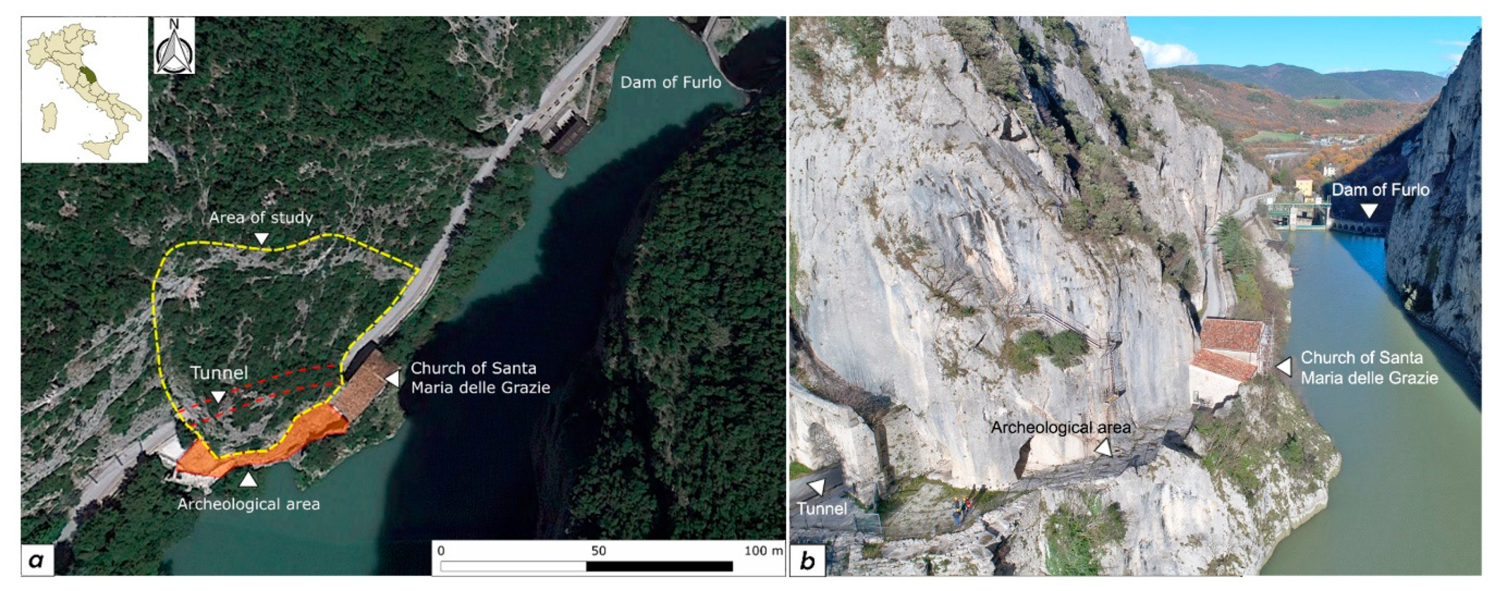
2. Study Area
3. Methodology
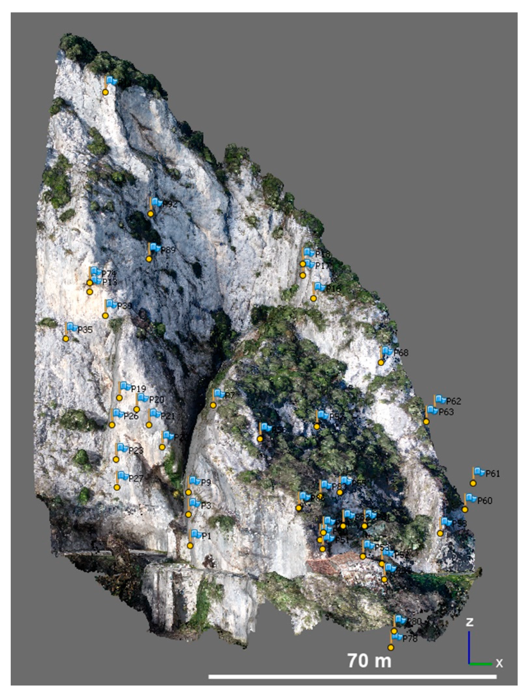
3.1. Topographic, TLS, and UAV Surveys
3.2. Engineering-Geological Characterization of the Rock Mass and Stability Analysis
3.3. Rockfall Runout Analysis
4. Results
4.1. D Modelling
4.2. Stability Analysis
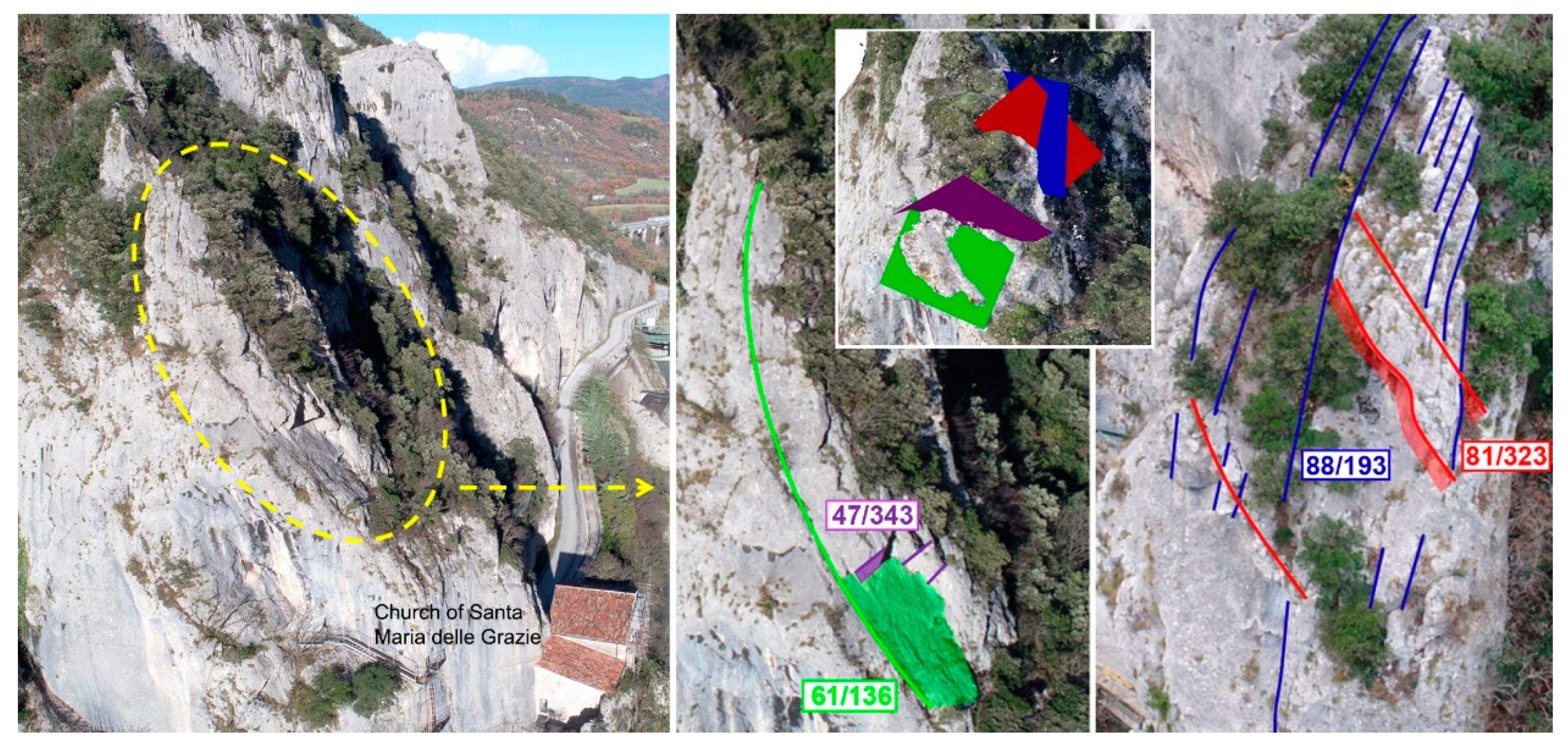
4.2.1. Engineering-Geological Characterization
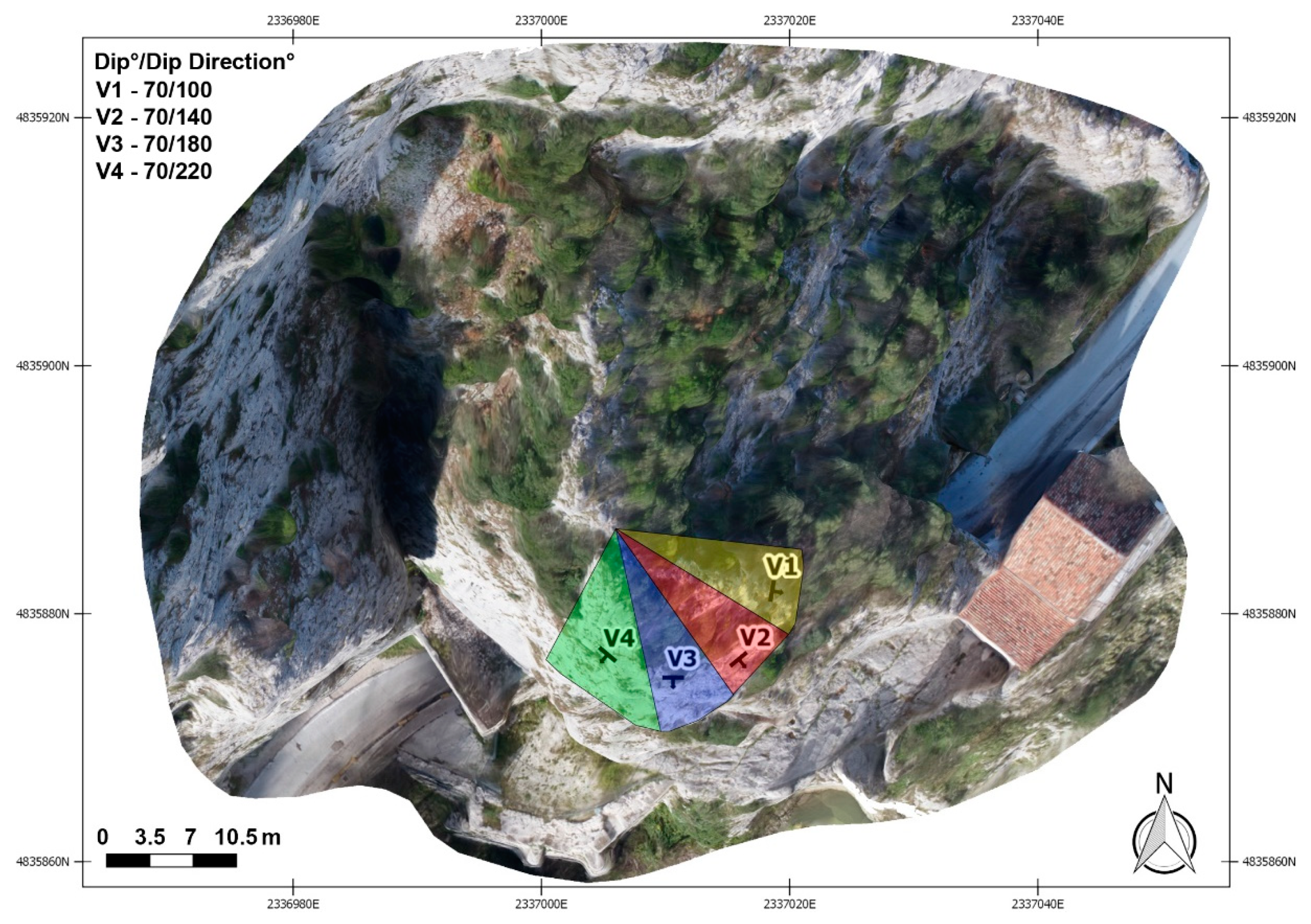
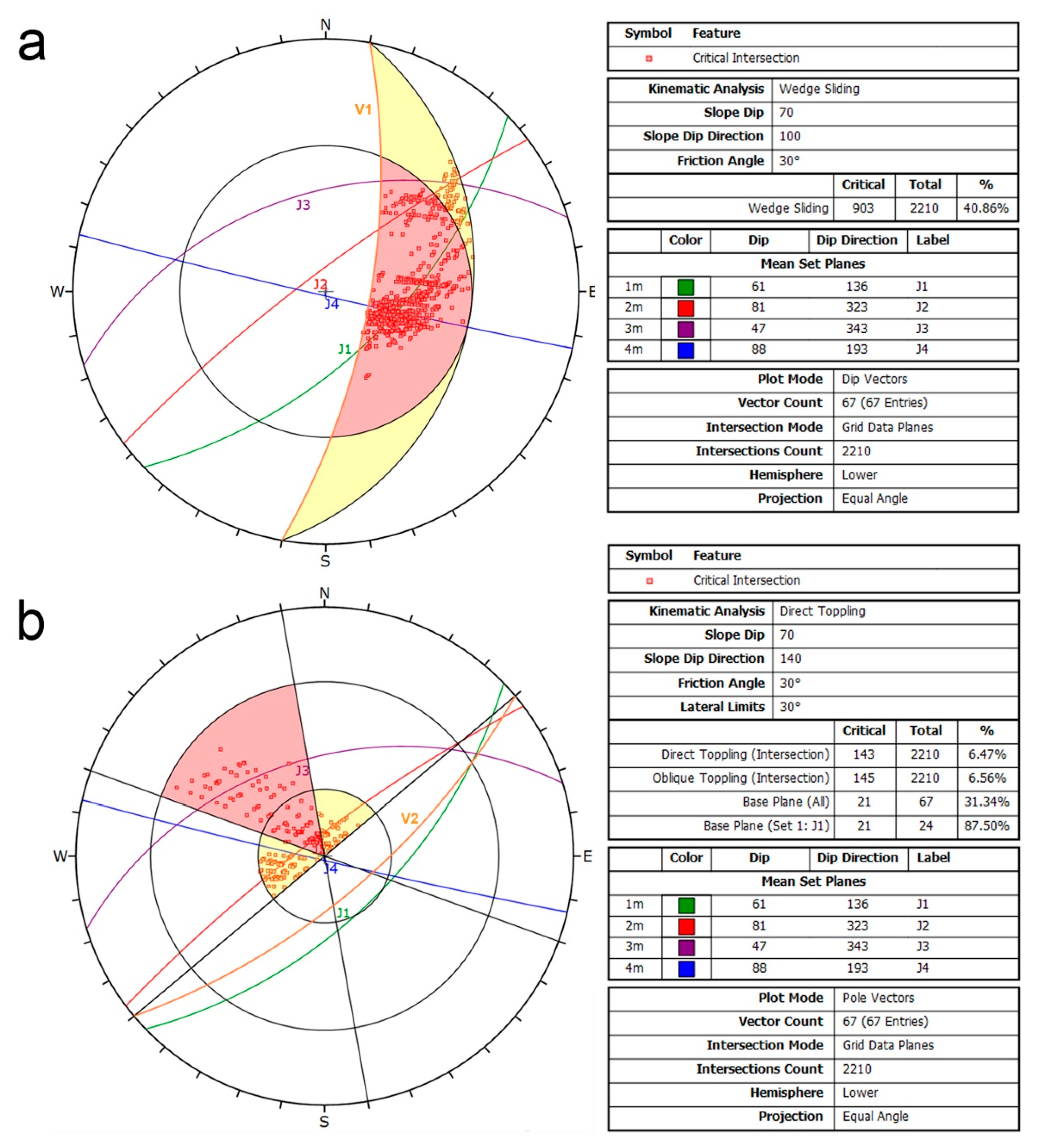
4.2.2. Kinematic Stability Analysis
4.3. Rockfall Analysis
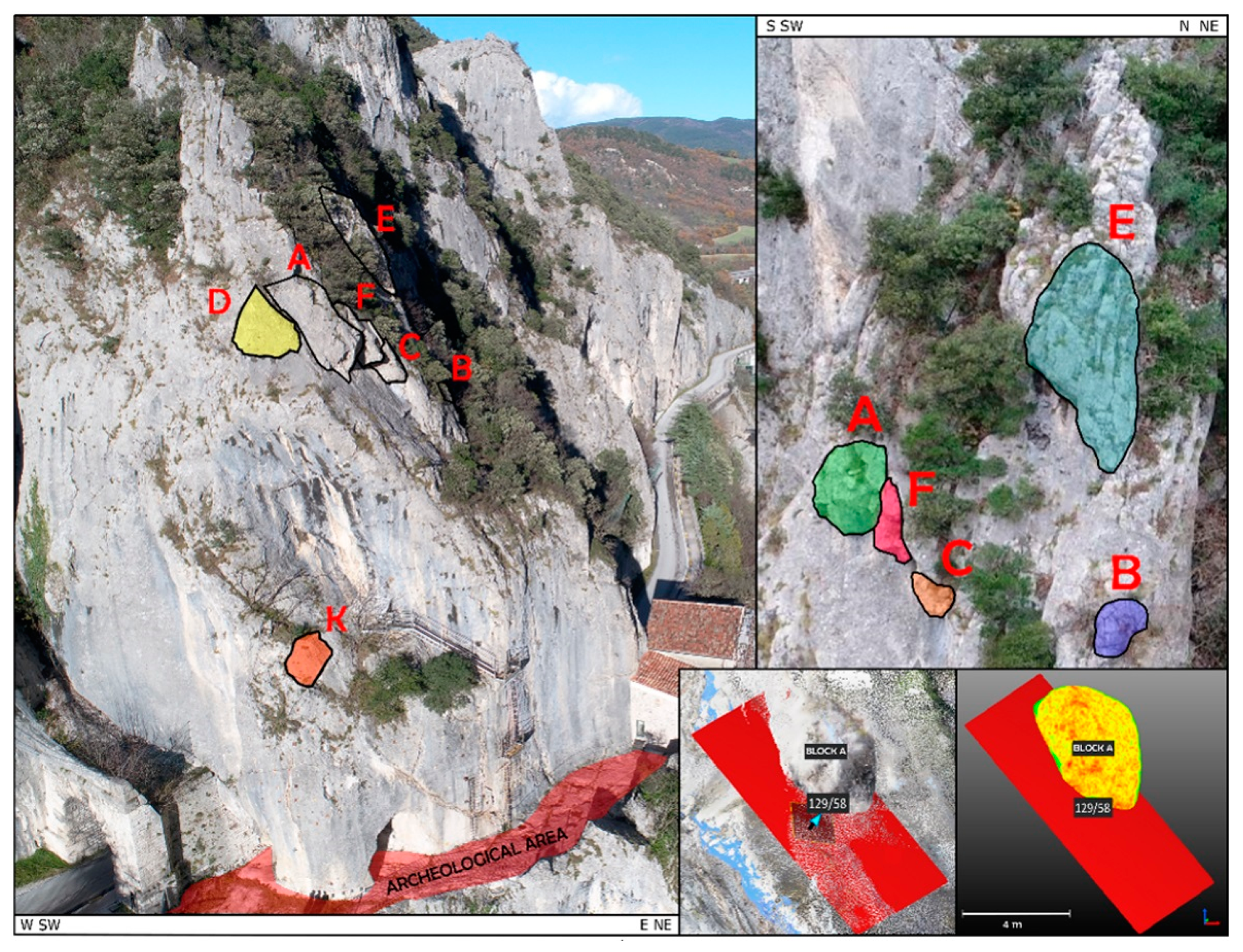
4.3.1. Unstable Block Identification and Dynamic Stability Analysis
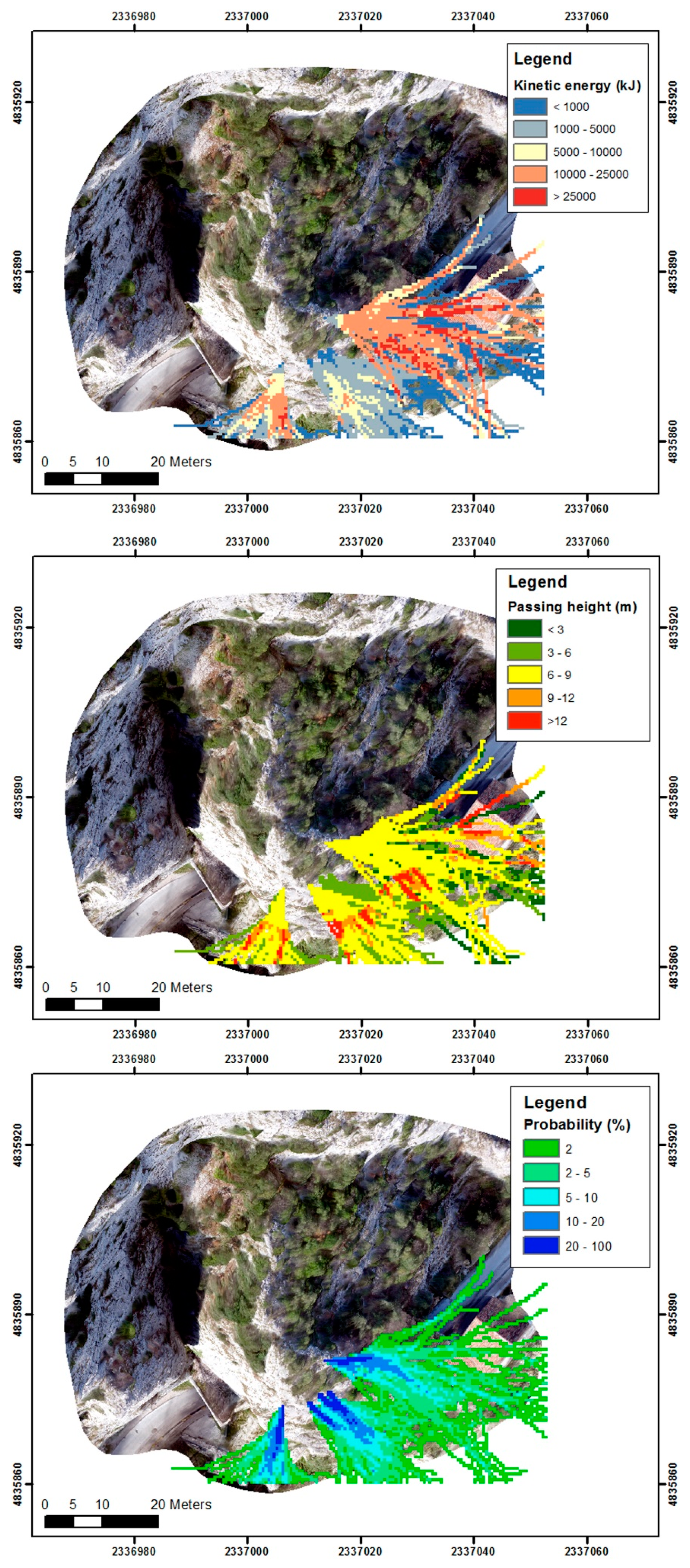
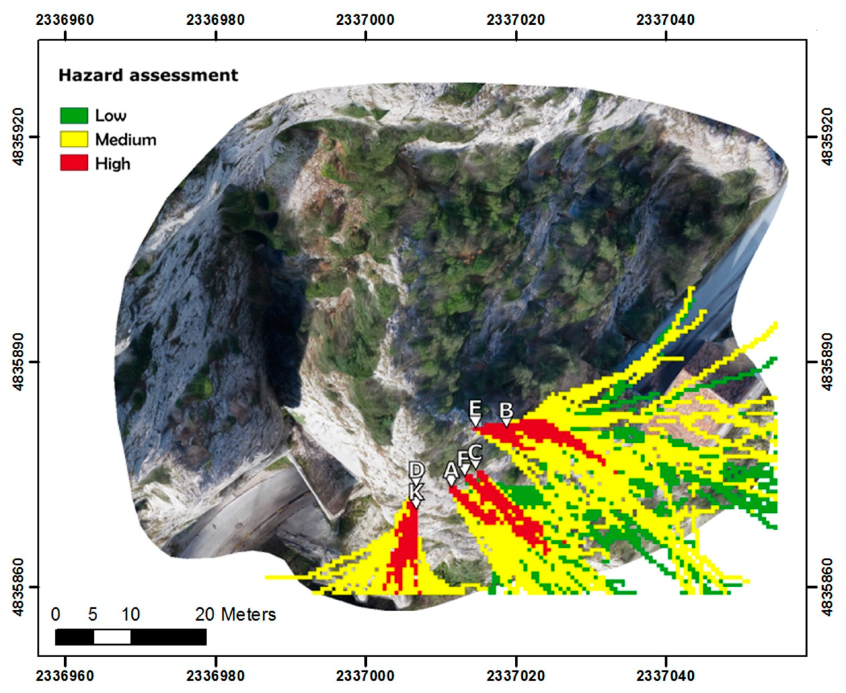
4.3.2. Rockfall Runout and Hazard Assessment
- Kinetic energy at the 95% confident level (translational + rotational, in kJ) of all blocks that passed over a single cell.
- Passing height values at the 95% confident level (measured from the block barycenter in normal direction to the slope surface, in meters).
- Probability for a block to reach a specific cell (i.e., (Nr. Passages × 100)/(Nr. Simulations per source cell × Nr. Source cells)).
4.3.3. Simulation with Virtual Net Counters
5. Discussion
- inspection, surface cleaning, and controlled barring for blocks smaller than 1 m3;
- destruction and removal of the smallest blocks;
- wire mesh with reinforced ropes;
- wire mesh panels;
- rock bolts, harness with ropes, or wire rope panels;
- sealing/consolidation with suspensions and consolidating mixtures;
- reinforcing wall construction;
6. Conclusions
- Provides the possibility to obtain deterministic geometrical data about rock blocks (i.e., position on the slope, shape and volume) and discontinuities (i.e., dip and dip direction) in inaccessible areas with short working times and in a cost-effective manner thanks to SfM-MVS photogrammetry and UAV surveys.
- Provides the possibility to assess the stability conditions of single blocks, to compute their SFs, and to identify possible rockfall sources, thanks to the acquisition of detailed information about rock wedges volume and weight, slope orientation, and rock mass conditions.
- Provides the possibility to perform geological hazard studies that identify areas with high probability to be reached by rockfall events.
- Provides the possibility to simulate the presence of net counters that allow collection of information regarding energy, passing heights, and reach probability of blocks that can be used as quantitative data for protection measures planning.
Author Contributions
Funding
Acknowledgments
Conflicts of Interest
References
- Hungr, O.; Evans, S.G.; Hazzard, J. Magnitude and frequency of rock falls and rock slides along the main transportation corridors of southwestern British Columbia. Can. Geotech. J. 1999, 36, 224–238. [Google Scholar] [CrossRef]
- Gigli, G.; Morelli, S.; Fornera, S.; Casagli, N. Terrestrial laser scanner and geomechanical surveys for the rapid evaluation of rock fall susceptibility scenarios. Landslides 2014, 11, 1–14. [Google Scholar] [CrossRef]
- Lim, C.H.; Martin, C.D.; Herd, E.P.K. Rock fall hazard assessment along railways using GIS. In Proceedings of the Canadian Geotech. Conference, Québec City, QC, Canada, 24–27 October 2004; pp. 1–8. [Google Scholar]
- Lan, H.; Martin, C.D.; Zhou, C.; Lim, C.H. Rockfall hazard analysis using LiDAR and spatial modeling. Geomorphology 2010, 118, 213–223. [Google Scholar] [CrossRef]
- Pfeiffer, T.J.; Bowen, T. Computer simulation of rockfalls. Bull. Assoc. Eng. Geol. 1989, 26, 135–146. [Google Scholar] [CrossRef]
- Azzoni, A.; La Barbera, G.; Zaninetti, A. Analysis and prediction of rockfalls using a mathematical model. Int. J. Rock Mech. Min. Sci. Geomech. Abstr. 1995, 32, 709–724. [Google Scholar] [CrossRef]
- Antoniou, A.A.; Lekkas, E. Rockfall susceptibility map for Athinios port, Santorini Island, Greece. Geomorphology 2010, 118, 152–166. [Google Scholar] [CrossRef]
- Youssef, A.M.; Pradhan, B.; Al-Kathery, M.; Bathrellos, G.D.; Skilodimou, H.D. Assessment of rockfall hazard at Al-Noor Mountain, Makkah city (Saudi Arabia) using spatio-temporal remote sensing data and field investigation. J. Afr. Earth Sci. 2015, 101, 309–321. [Google Scholar] [CrossRef]
- Descoeudres, F. Three-dimensional dynamic calculation of rockfalls. In Proceedings of the International Congresson on Rock Mechanics, Montreal, QC, Canada, 30 August–3 September 1987. [Google Scholar]
- Agliardi, F.; Crosta, G. High resolution three-dimensional numerical modelling of rockfalls. Int. J. Rock Mech. Min. Sci. 2003, 40, 455–471. [Google Scholar] [CrossRef]
- Lan, H.; Martin, C.D.; Lim, C. RockFall analyst: A GIS extension for three-dimensional and spatially distributed rockfall hazard modeling. Comput. Geosci. 2007, 33, 262–279. [Google Scholar] [CrossRef]
- Chiessi, V.; D’Orefice, M.; Mugnozza, G.S.; Vitale, V.; Cannese, C. Geological, geomechanical and geostatistical assessment of rockfall hazard in San Quirico Village (Abruzzo, Italy). Geomorphology 2010, 119, 147–161. [Google Scholar] [CrossRef]
- Thoeni, K.; Giacomini, A.; Lambert, C.; Sloan, S.W.; Carter, J.P. A 3D discrete element modelling approach for rockfall analysis with drapery systems. Int. J. Rock Mech. Min. Sci. 2014, 68, 107–119. [Google Scholar] [CrossRef]
- Fanos, A.M.; Pradhan, B. A novel rockfall hazard assessment using laser scanning data and 3D modelling in GIS. Catena 2019, 172, 435–450. [Google Scholar] [CrossRef]
- Moos, C.; Fehlmann, M.; Trappmann, D.; Stoffel, M.; Dorren, L. Integrating the mitigating effect of forests into quantitative rockfall risk analysis–Two case studies in Switzerland. Int. J. Disaster Risk Reduct. 2018, 32, 55–74. [Google Scholar] [CrossRef]
- Fanti, R.; Gigli, G.; Lombardi, L.; Tapete, D.; Canuti, P. Terrestrial laser scanning for rockfall stability analysis in the cultural heritage site of Pitigliano (Italy). Landslides 2013, 10, 409–420. [Google Scholar] [CrossRef]
- Farvacque, M.; Lopez-Saez, J.; Corona, C.; Toe, D.; Bourrier, F.; Eckert, N. How is rockfall risk impacted by land-use and land-cover changes? Insights from the French Alps. Glob. Planet. Chang. 2019, 174, 138–152. [Google Scholar] [CrossRef]
- Shen, W.-G.; Zhao, T.; Crosta, G.B.; Dai, F. Analysis of impact-induced rock fragmentation using a discrete element approach. Int. J. Rock Mech. Min. Sci. 2017, 98, 33–38. [Google Scholar] [CrossRef] [Green Version]
- Lopez-Saez, J.; Corona, C.; Eckert, N.; Stoffel, M.; Bourrier, F.; Berger, F. Impacts of land-use and land-cover changes on rockfall propagation: Insights from the Grenoble conurbation. Sci. Total. Environ. 2016, 547, 345–355. [Google Scholar] [CrossRef] [PubMed]
- Hutchinson, J.N. Morphological and geotechnical parameters of landslides in relation to geology and hydrogeology, state-of-the-art report. In Proceedings of the 5th International Symposium on Landslides, Lausanne, Switzerland, 10–15 July 1988; Bonnard, C., Ed.; pp. 3–35. [Google Scholar]
- Evans, S.; Hungr, O. The assessment of rockfall hazard at the base of talus slopes. Can. Geotech. J. 1993, 30, 620–636. [Google Scholar] [CrossRef]
- Dorren, L.K. A review of rockfall mechanics and modelling approaches. Prog. Phys. Geogr. Earth Environ. 2003, 27, 69–87. [Google Scholar] [CrossRef]
- Giani, G.P.; Giacomini, A.; Migliazza, M.; Segalini, A. Experimental and Theoretical Studies to Improve Rock Fall Analysis and Protection Work Design. Rock Mech. Rock Eng. 2004, 37, 369–389. [Google Scholar] [CrossRef]
- Bellian, J.; Kerans, C.; Jennette, D. Digital Outcrop Models: Applications of Terrestrial Scanning Lidar Technology in Stratigraphic Modeling. J. Sediment. Res. 2005, 75, 166–176. [Google Scholar] [CrossRef] [Green Version]
- Lague, D.; Brodu, N.; Leroux, J. Accurate 3D comparison of complex topography with terrestrial laser scanner: Application to the Rangitikei canyon (N-Z). ISPRS J. Photogramm. Remote Sens. 2013, 82, 10–26. [Google Scholar] [CrossRef] [Green Version]
- Brothelande, E.; Lénat, J.-F.; Normier, A.; Bacri, C.; Peltier, A.; Paris, R.; Kelfoun, K.; Merle, O.; Finizola, A.; Garaebiti, E. Insights into the evolution of the Yenkahe resurgent dome (Siwi caldera, Tanna Island, Vanuatu) inferred from aerial high-resolution photogrammetry. J. Volcanol. Geotherm. Res. 2016, 322, 212–224. [Google Scholar] [CrossRef] [Green Version]
- Salvini, R.; Mastrorocco, G.; Esposito, G.; Di Bartolo, S.; Coggan, J.; Vanneschi, C. Use of a remotely piloted aircraft system for hazard assessment in a rocky mining area (Lucca, Italy). Nat. Hazards Earth Syst. Sci. 2018, 18, 287–302. [Google Scholar] [CrossRef] [Green Version]
- Vanneschi, C.; Eyre, M.; Francioni, M.; Coggan, J. The Use of Remote Sensing Techniques for Monitoring and Characterization of Slope Instability. Procedia Eng. 2017, 191, 150–157. [Google Scholar] [CrossRef] [Green Version]
- Abellán, A.; Oppikofer, T.; Jaboyedoff, M.; Rosser, N.J.; Lim, M.; Lato, M.J. Terrestrial laser scanning of rock slope instabilities. Earth Surf. Process. Landf. 2014, 39, 80–97. [Google Scholar] [CrossRef]
- Vanneschi, C.; Salvini, R.; Massa, G.; Riccucci, S.; Borsani, A. Geological 3D modeling for excavation activity in an underground marble quarry in the Apuan Alps (Italy). Comput. Geosci. 2014, 69, 41–54. [Google Scholar] [CrossRef] [Green Version]
- Assali, P.; Grussenmeyer, P.; Villemin, T.; Pollet, N.; Viguier, F. Surveying and modeling of rock discontinuities by terrestrial laser scanning and photogrammetry: Semi-automatic approaches for linear outcrop inspection. J. Struct. Geol. 2014, 66, 102–114. [Google Scholar] [CrossRef]
- Hofierka, J.; Gallay, M.; Bandura, P.; Šašak, J. Identification of karst sinkholes in a forested karst landscape using airborne laser scanning data and water flow analysis. Geomorphology 2018, 308, 265–277. [Google Scholar] [CrossRef]
- Mastrorocco, G.; Salvini, R.; Vanneschi, C. Fracture mapping in challenging environment: A 3D virtual reality approach combining terrestrial LiDAR and high definition images. Bull. Eng. Geol. Environ. 2018, 77, 691–707. [Google Scholar] [CrossRef]
- Vanneschi, C.; Eyre, M.; Venn, A.; Coggan, J.S. Investigation and modeling of direct toppling using a three-dimensional distinct element approach with incorporation of point cloud geometry. Landslides 2019, 16, 1453–1465. [Google Scholar] [CrossRef]
- Locat, J.; Locat, A.; Locat, P.; Robitaille, D.; Turmel, D.; Jaboyedoff, M.; Demers, D.; Oppikofer, T. Use of terrestrial laser scanning for the characterization of retrogressive landslides in sensitive clay and rotational landslides in river banks. Can. Geotech. J. 2009, 46, 1379–1390. [Google Scholar]
- Baltensweiler, A.; Walthert, L.; Ginzler, C.; Sutter, F.; Purves, R.S.; Hanewinkel, M. Terrestrial laser scanning improves digital elevation models and topsoil pH modelling in regions with complex topography and dense vegetation. Environ. Model. Softw. 2017, 95, 13–21. [Google Scholar] [CrossRef]
- Hancock, S.; Anderson, K.; Disney, M.; Gaston, K.J. Measurement of fine-spatial-resolution 3D vegetation structure with airborne waveform lidar: Calibration and validation with voxelised terrestrial lidar. Remote Sens. Environ. 2017, 188, 37–50. [Google Scholar] [CrossRef]
- Kim, D.H.; Balasubramaniam, A.S.; Gratchev, I. Application of photogrammetry and image analysis for rock slope investigation. Geotech. Eng. 2018, 49, 49–56. [Google Scholar]
- Salvini, R.; Mastrorocco, G.; Seddaiu, M.; Rossi, D.; Vanneschi, C. The use of an unmanned aerial vehicle for fracture mapping within a marble quarry (Carrara, Italy): Photogrammetry and discrete fracture network modelling. Geomat. Nat. Hazards Risk 2017, 8, 34–52. [Google Scholar] [CrossRef]
- Tufarolo, E.; Vanneschi, C.; Casella, M.; Salvini, R. Evaluation of camera positions and ground points quality in a gnss-nrtk based uav survey: Preliminary results from a practical test in morphological very complex areas. ISPRS-Int. Arch. Photogramm. Remote Sens. Spat. Inf. Sci. 2019, 42, 637–641. [Google Scholar] [CrossRef]
- Kasprak, A.; Bransky, N.D.; Sankey, J.B.; Caster, J.; Sankey, T.T. The effects of topographic surveying technique and data resolution on the detection and interpretation of geomorphic change. Geomorphology 2019, 333, 1–15. [Google Scholar] [CrossRef]
- Al-Halbouni, D.; Holohan, E.P.; Saberi, L.; Alrshdan, H.; Sawarieh, A.; Closson, D.; Walter, T.R.; Dahm, T. Sinkholes, subsidence and subrosion on the eastern shore of the Dead Sea as revealed by a close-range photogrammetric survey. Geomorphology 2017, 285, 305–324. [Google Scholar] [CrossRef] [Green Version]
- Spetsakis, M.; Aloimonos, J.Y. A multi-frame approach to visual motion perception. Int. J. Comput. Vis. 1991, 6, 245–255. [Google Scholar] [CrossRef]
- Gallup, D.; Frahm, J.-M.; Mordohai, P.; Yang, Q.; Pollefeys, M. Real-Time Plane-Sweeping Stereo with Multiple Sweeping Directions. In Proceedings of the 2007 IEEE Conference on Computer Vision and Pattern Recognition, Minneapolis, MN, USA, 17–22 June 2007; pp. 1–8. [Google Scholar]
- Goesele, M.; Snavely, N.; Curless, B.; Hoppe, H.; Seitz, S.M. Multi-view stereo for community photo collections. In Proceedings of the IEEE International Conference on Computer Vision, Minneapolis, MN, USA, 17–22 June 2007. [Google Scholar]
- Jancosek, M.; Shekhovtsov, A.; Pajdla, T. Scalable multiview stereo. In Proceedings of the IEEE Workshop on 3D Digital Imaging and Modeling, Kyoto, Japan, 27 September 2009; p. 8. [Google Scholar]
- Fanos, A.M.; Pradhan, B. Laser Scanning Systems and Techniques in Rockfall Source Identification and Risk Assessment: A Critical Review. Earth Syst. Environ. 2018, 2, 163–182. [Google Scholar] [CrossRef]
- Kromer, R.; Hutchinson, D.J.; Lato, M.; Gauthier, D.; Edwards, T. Managing rockfall risk through baseline monitoring of precursors using a terrestrial laser scanner. Can. Geotech. J. 2017, 54, 953–967. [Google Scholar] [CrossRef]
- Abellan, A.; Derron, M.-H.; Jaboyedoff, M. “Use of 3D Point Clouds in Geohazards” Special Issue: Current Challenges and Future Trends. Remote Sens. 2016, 8, 130. [Google Scholar] [CrossRef]
- Buill, F.; Núñez-Andrés, M.A.; Lantada, N.; Prades, A. Comparison of Photogrammetric Techniques for Rockfalls Monitoring. IOP Conf. Ser. Earth Environ. Sci. 2016, 44, 42023. [Google Scholar] [CrossRef] [Green Version]
- Wilkinson, M.W.; Jones, R.R.; Woods, C.E.; Gilment, S.R.; McCaffrey, K.J.W.; Kokkalas, S.; Long, J.J. A comparison of terrestrial laser scanning and structure-frommotion photogrammetry as methods for digital outcrop acquisition. Geosphere 2016, 12, 1865–1880. [Google Scholar] [CrossRef]
- Sarro, R.; Riquelme, A.; García-Davalillo, J.C.; Mateos, R.M.; Tomás, R.; Pastor, J.L.; Cano, M.; Herrera, G. Rockfall Simulation Based on UAV Photogrammetry Data Obtained during an Emergency Declaration: Application at a Cultural Heritage Site. Remote Sens. 2018, 10, 1923. [Google Scholar] [CrossRef]
- Saroglou, C.; Asteriou, P.; Zekkos, D.; Tsiambaos, G.; Clark, M.; Manousakis, J. UAV-based mapping, back analysis and trajectory modeling of a coseismic rockfall in Lefkada island, Greece. Nat. Hazards Earth Syst. Sci. 2018, 18, 321–333. [Google Scholar] [CrossRef] [Green Version]
- Salvini, R.; Francioni, M. Geomatics for slope stability and rock fall runout analysis: A case study along the alta tambura road in the apuan alps (Tuscany, Italy). Ital. J. Eng. Geol. Environ. 2013, 481–492. [Google Scholar]
- Salvini, R.; Francioni, M.; Riccucci, S.; Bonciani, F.; Callegari, I. Photogrammetry and laser scanning for analyzing slope stability and rock fall runout along the Domodossola-Iselle railway, the Italian Alps. Geomorphology 2013, 185, 110–122. [Google Scholar] [CrossRef]
- Žabota, B.; Repe, B.; Kobal, M. Influence of digital elevation model resolution on rockfall modelling. Geomorphology 2019, 328, 183–195. [Google Scholar] [CrossRef]
- Frattini, P.; Crosta, G.; Carrara, A.; Agliardi, F. Assessment of rockfall susceptibility by integrating statistical and physically-based approaches. Geomorphology 2008, 94, 419–437. [Google Scholar] [CrossRef]
- Dussauge-Peisser, C.; Helmstetter, A.; Grasso, J.-R.; Hantz, D.; Desvarreux, P.; Jeannin, M.; Giraud, A. Probabilistic approach to rock fall hazard assessment: Potential of historical data analysis. Nat. Hazards Earth Syst. Sci. 2002, 2, 15–26. [Google Scholar] [CrossRef]
- Colantoni, P.; Menichetti, M.; Savelli, D.; Tramontana, M. Carta Geologico e Geomorfologica; University of Urbino: Urbino, Italy, 2012. [Google Scholar]
- Pichezzi, R.M. Carta Geologica d’Italia a Scala 1:50.000-Foglio 280 (Fossombrone); ISPRA Serv. Geologico d’Italia: Roma, Italy, 2016. [Google Scholar]
- Pergolini, C.; Farina, D. Gli aspetti geografici, geologici, paleontologici. In I Monti del Furlo; Regione Marche, Comunità Montane Metauro, Alto e Medio Metauro, Catria e Nerone: Ancona, Italy, 1990; pp. 11–36. [Google Scholar]
- Centamore, E.; Deiana, G. Carta Geologica delle Marche a Scala 1:250.000; Università di Camerino e Regione Marche, LAC: Firenze, Italy, 1986. [Google Scholar]
- Del Prete, M. Progetto per la Realizzazione di reti di Protezione ed Altre Opera e Attività Complementari Sulle Pareti Rocciose Soggette a Crollo Sovrastanti la via Flaminia, nel Tratto Compreso tra la Galleria Romana e le Località Furlo; Technical Report; Amministrazione Provinciale di Pesaro e Urbino: Pesaro, Italy, 2012; p. 11. [Google Scholar]
- Centamore, E.; Cantalamessa, G.; Micarelli, A.; Potetti, M.; Berti, D.; Bigi, S.; Morelli, C.; Ridolfi, M. Stratigrafia e analisi di facies dei depositi del Miocene e del pliocene inferiore dell’avanfossa marchigiano-abruzzese e delle zone limitrofe. Stud. Geol. Camerti 1991, 11, 121–131. [Google Scholar]
- Besl, P.; McKay, H. A method for registration of 3-D shapes. IEEE Trans. Pattern Anal. Mach. Intell. 1992, 14, 239–256. [Google Scholar] [CrossRef]
- Cima, V.; Carroccio, M.; Maseroli, R. Corretto utilizzo dei Sistemi Geodetici di Riferimento all’interno dei software GIS. In Proceedings of the Atti 18a Conferenza Nazionale ASITA, Firenze, Italy, 14–16 October 2014; pp. 359–363. [Google Scholar]
- Hansman, R.J.; Ring, U. Workflow: From photo-based 3-D reconstruction of remotely piloted aircraft images to a 3-D geological model. Geosphere 2019, 15, 16. [Google Scholar] [CrossRef]
- Chudley, T.R.; Christoffersen, P.; Doyle, S.H.; Abellan, A.; Snooke, N. High-accuracy UAV photogrammetry of ice sheet dynamics with no ground control. Cryosphere 2019, 13, 955–968. [Google Scholar] [CrossRef] [Green Version]
- Bieniawski, Z.T. Engineering Classification of Jointed Rock Masses. Civ. Eng. South. Afr. 1973, 15. [Google Scholar]
- Bieniawski, Z.T. Engineering Rock Mass Classifications: A Complete Manual for Engineers and Geologists in Mining, Civil, And Petroleum Engineering; Wiley-Interscience Publication: New York, NY, USA, 1989; p. 272. [Google Scholar]
- Hoek, E.; Brown, E. Practical estimates of rock mass strength. Int. J. Rock Mech. Min. Sci. 1997, 34, 1165–1186. [Google Scholar] [CrossRef]
- Thiele, S.T.; Grose, L.; Samsu, A.; Micklethwaite, S.; Vollgger, S.A.; Cruden, A.R. Rapid, semi-automatic fracture and contact mapping for point clouds, images and geophysical data. Solid Earth 2017, 8, 1241–1253. [Google Scholar] [CrossRef] [Green Version]
- Markland, J.T. A Useful Technique for Estimating the Stability of Rock Slopes When the Rigid Wedge Sliding Type of Failure Is Expected; Tylers Green, H.W., Ed.; Imperial College of Science and Technology: London, UK, 1972; Volume 19. [Google Scholar]
- Gigli, G.; Casagli, N. Semi-automatic extraction of rock mass structural data from high resolution LIDAR point clouds. Int. J. Rock Mech. Min. Sci. 2011, 48, 187–198. [Google Scholar] [CrossRef]
- Ferrero, A.M.; Forlani, G.; Roncella, R.; Voyat, H.I. Advanced geostructural survey methods applied to rock mass characterization. Rock Mech. Rock Eng. 2009, 42, 631–665. [Google Scholar] [CrossRef]
- Mavrouli, O.; Corominas, J.; Jaboyedoff, M. Size Distribution for Potentially Unstable Rock Masses and In Situ Rock Blocks Using LIDAR-Generated Digital Elevation Models. Rock Mech. Rock Eng. 2015, 48, 1589–1604. [Google Scholar] [CrossRef]
- Chen, N.; Kemeny, J.; Jiang, Q.; Pan, Z. Automatic extraction of blocks from 3D point clouds of fractured rock. Comput. Geosci. 2017, 109, 149–161. [Google Scholar] [CrossRef]
- Kazhdan, M.; Bolitho, M.; Hoppe, H. Poisson surface reconstruction. In Proceedings of the Fourth Eurographics Symposium on Geometry Processing, Sardinia, Italy, 26–28 June 2006; pp. 61–70. [Google Scholar]
- Ministero dei Lavori Pubblici. NTC-Norme Tecniche per le Costruzioni; Repubblica Italiana: Roma, Italy, 2018. [Google Scholar]
- Gallego, J.G.; Fonseca, R.J.L. Optimization criteria for using dynamic rockfall protection systems. In Proceedings of the Second Half Century of Rock Mechanics, Lisbon, Portugal, 9–13 July 2007; Riberio, L., Sousa Olalla, C., Grossmann, N., Eds.; pp. 637–640. [Google Scholar]
- Dorren, L.K.A. Rockyfor3d (V5.1) Revealed–Transparent Description of the Complete 3d Rockfall Model; ecorisQ Association: Geneva, Switzerland, 2012. [Google Scholar]
- Dorren, L.K.A.; Heuvelink, G.B.M. Effect of support size on the accuracy of a distributed rockfall model. Int. J. Geogr. Inf. Sci. 2004, 18, 595–609. [Google Scholar] [CrossRef]
- Netti, T.; Castelli, M.; De Biagi, V. Effect of the Number of Simulations on the Accuracy of a Rockfall Analysis. Procedia Eng. 2016, 158, 464–469. [Google Scholar] [CrossRef] [Green Version]


| Input Raster | Description |
|---|---|
| DTM | It represents the DTM of the slope. |
| Rock density | It represents the rock density of every simulated source cell (i.e., falling block). |
| Block height, width and length | These three raster maps describe the shape of a block, in terms of height, width, and length. |
| Block shape | It defines the shape of a falling block (i.e., rectangular, ellipsoidal, spherical, and disc shaped). |
| Roughness 70, 20, 10 | These three raster maps define the roughness of the slope surface, represented by all the obstacles lying on the slope. The value of every cell, expressed in meters, corresponds to the height of a representative obstacle that can be encountered by a block with a probability of 70% (rg70), 20% (rg20) and 10% (rg10). The values range from 0 to 100 and are used to calculate the tangential coefficient of restitution (Rt) causing an energy loss. |
| Soil type | This raster map defines the elasticity of the ground surface basing on the soil type; there are eight different soil types (e.g., bedrock, asphalt road, fine soil material) and every type corresponds to a certain value of the normal coefficient of restitution (Rn). |
| Set | Mean Dip | Mean Dip Direction |
|---|---|---|
| J1 | 61 | 136 |
| J2 | 81 | 323 |
| J3 | 47 | 343 |
| J4 | 88 | 193 |
| Versant | Planar Sliding | Wedge Sliding | Direct Toppling |
|---|---|---|---|
| Critical System or Critical Intersection | |||
| V1 (100/70) | J1 | J1–J4 | / |
| V2 (140/70) | J1 | J1–J4 | J2–J4–J1 |
| V3 (180/70) | J1 | / | / |
| V4 (220/70) | / | J3–J4 | / |
| ID | Volume (M3) | Discontinuity | Discontinuity Set | Block Centroid Coordinates (M) | Most Critical SF (Dynamic Condition) | ||||||
|---|---|---|---|---|---|---|---|---|---|---|---|
| Dip Direction (°) | Dip (°) | J1 | J2 | J3 | J4 | X | Y | Z | |||
| A | 12.41 | 129 | 58 | X | 2,337,011.05 | 4,835,874.36 | 223.76 | 1.03 | |||
| 005 | 80 | X | |||||||||
| B | 0.25 | 108 | 63 | X | 2,337,018.14 | 4,835,881.80 | 221.24 | * | |||
| C | 2.88 | 129 | 58 | X | 2,337,014.10 | 4,835,876.41 | 220.97 | 1.20 | |||
| 181 | 75 | X | |||||||||
| D | 11.50 | 202 | 59 | 2,337,006.44 | 4,835,873.76 | 225.89 | 1.08 | ||||
| E | 13.14 | 108 | 63 | X | 2,337,014.07 | 4,835,881.93 | 229.17 | 1.09 | |||
| F | 5.92 | 129 | 58 | X | 2,337,012.77 | 4,835,875.91 | 223.69 | 1.10 | |||
| 006 | 80 | X | |||||||||
| K | 2.39 | 175 | 81 | X | 2,337,006.54 | 4,835,871.14 | 205.26 | 1.01 | |||
| 140 | 50 | X | |||||||||
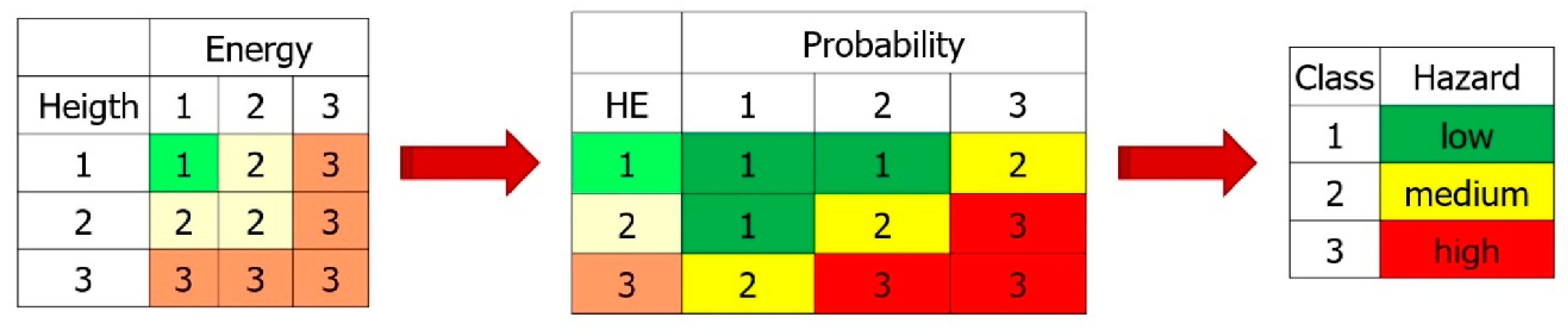
| Energy (kJ) | Height (m) | Probability (%) | |||
|---|---|---|---|---|---|
| Class | Value | Class | Value | Class | Value |
| 1 | ≤1100 | 1 | ≤2 | 1 | ≤10 |
| 2 | 1100 < kJ ≤ 5000 | 2 | 2 < m ≤ 5 | 2 | 10 < % ≤ 20 |
| 3 | >5000 | 3 | >5 | 3 | 20 < % ≤ 100 |
| Block ID | Net ID | Energy (kJ) | Height (m) | Number of Passages | Probability (%) |
|---|---|---|---|---|---|
| A | 2 | 6394.9 | 11.7 | 817 | 81.7 |
| 3 | 191.1 | 2.3 | 1 | 0.1 | |
| B | 2 | 132.7 | 2.7 | 25 | 2.5 |
| 3 | 192.9 | 5.9 | 850 | 85 | |
| 4 | 221.5 | 7.1 | 76 | 7.6 | |
| C | 2 | 2595.1 | 9.1 | 987 | 98.7 |
| 3 | 1113.7 | 1.7 | 3 | 0.3 | |
| D | 1 | 9174 | 11.5 | 953 | 95.3 |
| 2 | 5054 | 3.6 | 3 | 0.3 | |
| E | 2 | 22,229.3 | 6.9 | 41 | 4.1 |
| 3 | 27,054.5 | 8.4 | 553 | 55.3 | |
| 4 | 25,881.5 | 9.8 | 43 | 4.3 | |
| F | 2 | 1458 | 5.8 | 987 | 98.7 |
| 3 | 1162.3 | 1.7 | 3 | 0.3 | |
| K | 1 | 1005 | 5.8 | 997 | 99.7 |
© 2019 by the authors. Licensee MDPI, Basel, Switzerland. This article is an open access article distributed under the terms and conditions of the Creative Commons Attribution (CC BY) license (http://creativecommons.org/licenses/by/4.0/).
Share and Cite
Vanneschi, C.; Di Camillo, M.; Aiello, E.; Bonciani, F.; Salvini, R. SfM-MVS Photogrammetry for Rockfall Analysis and Hazard Assessment Along the Ancient Roman Via Flaminia Road at the Furlo Gorge (Italy). ISPRS Int. J. Geo-Inf. 2019, 8, 325. https://doi.org/10.3390/ijgi8080325
Vanneschi C, Di Camillo M, Aiello E, Bonciani F, Salvini R. SfM-MVS Photogrammetry for Rockfall Analysis and Hazard Assessment Along the Ancient Roman Via Flaminia Road at the Furlo Gorge (Italy). ISPRS International Journal of Geo-Information. 2019; 8(8):325. https://doi.org/10.3390/ijgi8080325
Chicago/Turabian StyleVanneschi, Claudio, Marco Di Camillo, Eros Aiello, Filippo Bonciani, and Riccardo Salvini. 2019. "SfM-MVS Photogrammetry for Rockfall Analysis and Hazard Assessment Along the Ancient Roman Via Flaminia Road at the Furlo Gorge (Italy)" ISPRS International Journal of Geo-Information 8, no. 8: 325. https://doi.org/10.3390/ijgi8080325
APA StyleVanneschi, C., Di Camillo, M., Aiello, E., Bonciani, F., & Salvini, R. (2019). SfM-MVS Photogrammetry for Rockfall Analysis and Hazard Assessment Along the Ancient Roman Via Flaminia Road at the Furlo Gorge (Italy). ISPRS International Journal of Geo-Information, 8(8), 325. https://doi.org/10.3390/ijgi8080325