Article

From Geodata to Immersive Heritage Experiences: A Virtual Reality Case Study in Gorzów Wielkopolski, Poland


1
Applied Geomatics Center, Institute of Geodesy and Cartography, 02-679 Warsaw, Poland
2
Faculty of Environmental Engineering and Mechanical Engineering, Poznan University of Life Sciences, 60-637 Poznan, Poland
3
Department of Cartography and Geomatics, Adam Mickiewicz University Poznan, 61-680 Poznan, Poland
*
Author to whom correspondence should be addressed.
ISPRS Int. J. Geo-Inf. 2026, 15(8), 344; https://doi.org/10.3390/ijgi15080344
Submission received: 15 May 2026 / Revised: 29 July 2026 / Accepted: 31 July 2026 / Published: 1 August 2026

Abstract

Virtual reality and geovisualization offer new ways to present, study, and experience geographic space, including urban cultural heritage. This article presents the process of creating a gamified VR application focused on selected preserved monuments in the centre of Gorzów Wielkopolski, Poland, a city whose historic fabric was strongly affected by World War II. The aim of the project was not only to introduce users to the city’s cultural heritage, but also to encourage greater interest in, respect for, and appreciation of that heritage. The work was divided into four stages: conceptual design, data preparation, implementation, and publication/evaluation. The application was developed using geospatial data, orthophotography, LoD1 building models, field photographs, archival postcards, manual 3D modelling, interface design, and implementation in Unity. The final VR environment allows users to explore part of the city, view information about monuments, match historical postcards with buildings, receive feedback, collect points, and move between stations. The application was additionally evaluated through an online questionnaire completed by 20 students. The results indicated a generally positive perception of its educational and heritage-communication potential, while the realism of the vegetation appears to be an area that could benefit from further improvement. The case study shows that immersive geovisualization can support spatial understanding, engagement, and heritage communication, and presents a workflow that may be adapted for similar cultural heritage projects.

1. Introduction

With the growing availability of digital technologies and geospatial data, geovisualization integrates cartography, GIS, and data visualization to facilitate the exploration, analysis, and communication of spatial information [1]. One important area of development is the presentation of three-dimensional environments, including 3D models of buildings and cultural heritage sites in VR. In the context of VR, ref. [2] emphasizes the importance of geovisualization methods for educational and research-oriented studies of geographic space. The aim of the study is to examine how geovisualization, virtual reality, and game elements can be integrated into a gamified immersive heritage application for the communication of local cultural heritage. The research question is whether such an application can provide an engaging and educationally meaningful way of presenting heritage resources to contemporary users. The article contributes to the literature by combining geovisualization principles, immersive VR, and gamified interaction within a single heritage-oriented application grounded in a specific urban context. Its novelty lies in linking present-day monuments with archival postcards and the historical legacy of a city marked by wartime destruction. This approach is also relevant in relation to the still underdeveloped potential of sentimental tourism in Gorzów Wielkopolski, including among descendants of former residents of Landsberg who may seek access to the tangible and intangible heritage of their ancestors [3]. While previous studies have explored either immersive visualization or serious games, fewer have focused on their integration within a geodata-driven urban framework. The developed application was additionally evaluated through a questionnaire survey conducted among students, which examined their perceptions of the visual realism, engagement potential, and educational value of the proposed immersive geovisualization.
Accordingly, the study was guided by two main research questions. The first concerns the methodological and technological integration of geospatial data, virtual reality, and gamification within a coherent framework for presenting urban cultural heritage. The second focuses on the users’ perception of the developed application, particularly its potential to support engagement, spatial understanding, and the communication and memorization of heritage-related information. These questions were formulated as follows:
  • How can geovisualization, virtual reality, and gamification be integrated into a coherent application for presenting and interpreting urban cultural heritage?
  • To what extent does the developed VR application support user engagement, spatial understanding, and the communication and memorization of information about cultural heritage?
Virtual reality provides an important technological framework for such applications. VR is a display and control technology that provides an interactive, multi-sensory, computer-generated, three-dimensional virtual environment (VE) to a user [4]. The technical purpose of VR is to generate computer-mediated sensations that replace real sensory experience [5]. As a result, VR has become an increasingly important medium for the geovisualization of urban space and virtual walks through digitally reconstructed historic buildings and streets that no longer exist [6]. In the context of VR, the concepts of presence and immersion are central. Presence refers to the sensation of being in a virtual environment despite knowing that one is not physically there [7]. Currently, immersive geovisualization also allows for more direct observation of geographic phenomena and presence in a modelled virtual topographic space [8]. VR has become a popular immersive reality technology for disseminating cultural knowledge in the field of virtual heritage, particularly suited to the historical and cultural context of museums and heritage sites [9].
These issues are particularly relevant in the presentation of urban space and cultural heritage. The virtual 3D cities are important for visual communication and for conveying urban-related information, but they also stress that such models should account for human spatial cognition [10]. VR is therefore valuable not only as a medium of representation, but also as a tool that allows users to virtually visit, explore, and interact with cultural heritage [5]. At the same time, the growing accessibility of VR technologies has strengthened their practical potential. Halik and Kent [4] point to the need for immersive and intuitive 3D environments, especially in applications requiring realistic simulation and interaction, such as games. In the context of cultural heritage, this intersects with the development of game-based learning. Theodoropoulos and Antoniou [11] argue that games related to cultural heritage are an effective way to introduce users to heritage content, while their educational value can be adapted through different technologies, game types, and interaction models. This is particularly relevant for younger audiences, for whom digital games are a familiar medium. VR games may support learning, enjoyment, and physical activity, while also offering effective simulated environments for visualization [11,12].
Game engines are especially useful in this context. A game engine can be defined as an open and extendable software system for developing video games for computers, consoles, and mobile devices [13,14]. Such engines typically include rendering, animation, physics, and audio components [13], and they support realistic virtual environments, high graphical quality, multiple 3D data formats, and first-person interaction [12,15].

2. Literature Overview

VR-based games have increasingly been recognized as effective tools for cultural awareness, historical reconstruction, and heritage education because they enable immersive interaction with virtually recreated environments and can enhance user experience beyond what other visualization technologies typically offer [11]. Cartographic interfaces designed in video games are used for exploration and navigation in virtual geographical space and are additionally supplemented with texts about objects [16].
The literature commonly distinguishes three levels of VR immersion: non-immersive, semi-immersive, and fully immersive VR. Non-immersive VR refers to desktop-based applications in which users explore three-dimensional environments on a computer screen, for example, in the form of virtual museum tours. Semi-immersive VR occupies an intermediate position, offering a stronger sense of presence than desktop-based systems while maintaining the user’s partial awareness of the physical environment. This category typically includes large displays and projection-based systems, which can enhance user engagement and interaction with heritage content, although they do not provide full sensory enclosure. Fully immersive VR, by contrast, seeks to place the user entirely within a computer-generated environment through head-mounted displays and motion-tracking systems. This category is particularly relevant to cultural heritage applications because it enables more natural spatial interaction and a stronger experiential connection with reconstructed or interpreted sites [17].
An example of a VR game is a VR game which is set in Ostrów Lednicki in Poland, combining heritage visualization with game mechanics such as a minimap, navigation modes, and coin collection [18]. Similarly, ref. [19] described the ArkaeVision Archeo application, which allows users to explore the Temple of Hera II in Paestum within a guided VR experience supported by a narrative digital character. The result of the work with reconstructed historical data could be the creation of cultural heritage visualization that presents the interactive landscape reconstruction as an immersive geovisualization of a typical medieval Eastern European earth-and-timber stronghold [20].

2.1. Serious Games and Gamification

Serious games and gamification are widely discussed in the literature on digital heritage and educational technologies. According to [13], serious games combine entertainment and educational components and are applied in many different fields. Their purpose is not limited to amusement; they also provide educational value and can effectively engage users in learning cultural content [11,13]. In the context of cultural heritage, serious games may take various forms, including quizzes, puzzles, minigames, interactive exhibitions, mobile applications supporting museum or site visits, simulations of past events, and role-playing games based on faithful reconstructions or equivalents of real places [21]. As [21] notes, such games are used in cultural tourism and in the exploration of cities, natural landscapes, archaeological sites, and museums in order to enhance visitors’ real-world experiences and strengthen their engagement with cultural information.
Gamification, in turn, refers to the deliberate use of game design elements and principles in non-game contexts in order to increase engagement, motivation, problem solving, and the overall quality of user experience [22]. This concept is closely related to serious games and game-based learning [23]. Whereas game-based learning is based on the use of a complete game for educational purposes, often in the form of a serious game, gamification involves the incorporation of selected game elements into activities that are not games in themselves [23]. These concepts share a common orientation toward the use of positive game experiences for purposes extending beyond entertainment, such as education or behavioural change [23]. Among the most frequently cited game design elements are points, badges, leaderboards, performance graphs, meaningful stories, avatars, and teammates [24].

2.2. Technologies Used in the Creation of Geovisualization of Cultural Heritage with Game Elements

The literature reviewed indicates that a common method of presenting 3D models of cultural heritage involves the use of game engines such as Unity or Unreal Engine. Ref. [25], for example, presented an approach combining GIS and BIM for the visualization of historic urban blocks and buildings in Taiwan. In that study, a Unity-based application integrated historic 3D buildings with a GIS database and enabled the adjustment of settings for different user groups, including GIS specialists and architects. According to [25], the integration of game-environment development with interactive 3D technologies improves users’ understanding of the environmental characteristics of old urban areas and supports design evaluation.
Another frequently applied approach involves laser scanning, where point-cloud data are later transformed into 3D models and imported into a game engine. Such a workflow was used, for example, in the inventory of the Kłodzko Fortress presented by [26], where scanning data subsequently supported the development of an application for cultural heritage promotion. In addition, 3D modelling software is often employed in heritage visualization projects. In Ma’s study [25], SketchUp was used to model historic buildings and old urban blocks in Taiwan with the support of procedural modelling techniques. These models were then integrated with a GIS database using a programming script, resulting in a VR application intended for GIS users and architects.
Such combinations of GIS, 3D modelling, scanning data, and game engines enable more efficient visualization, exploration, and management of complex urban heritage environments [25]. At the same time, VR environments and game engines increase the interactivity of cultural heritage presentations and support more engaging user experiences in both educational and professional contexts [12,15]. An example of immersive geovisualization designed using a game engine is a city game that involves matching old postcards to modern 3D buildings. In this case, the Unreal application was used [27]. The player’s task is to first examine old postcards at a bus stop and then find the contemporary view in the city that corresponds to each postcard [28].

3. Materials and Methods

3.1. Study Area

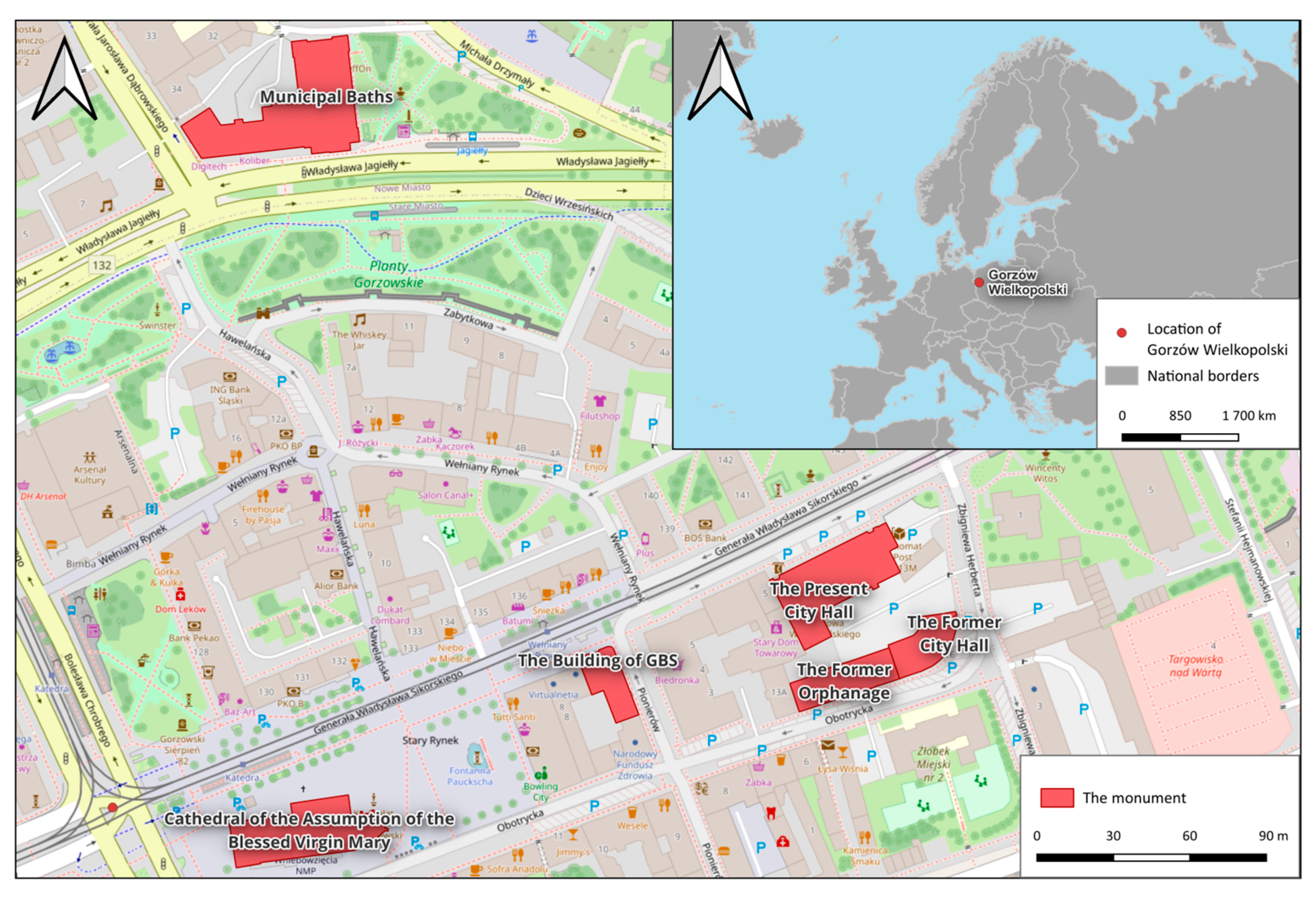
The study area is Gorzów Wielkopolski, a city in western Poland located in the Lubusz Voivodeship (Figure 1). It lies at the junction of the Gorzów Basin, forming part of the Toruń-Eberswalde Valley, and the Gorzów Plain, at the mouth of the Kłodawka River into the Warta River [29].
The original urban layout developed in an oval form, with its main axis along present-day Władysława Sikorskiego Street, connecting the historical city gates [30]. This spatial arrangement was typical of Brandenburg towns, with religious functions concentrated on one side of the market square and secular functions on the other [30,31,32]. Until World War II, the city still retained many features of a medieval town [32]. However, after the capture of Gorzów by Soviet troops on 30 January 1945, the city suffered severe destruction. Post-war estimates indicate that approximately 35.5% of residential buildings and around 60% of industrial buildings were destroyed, and only a limited number of historic buildings survived [29]. The post-war redevelopment of the city centre ultimately followed the Warsaw concept based on housing-estate construction rather than the reconstruction of the historic urban fabric [29,31].
This historical context makes Gorzów Wielkopolski a relevant case study for virtual heritage presentation. Although much of the historic centre was lost, several monuments have survived and still define the cultural identity of the city centre. The monuments selected for this study are listed in Table 1. They include the Cathedral of the Assumption of the Blessed Virgin Mary, the oldest preserved building in the city, dating to the 13th century [30,33,34], the Former Orphanage and the Former City Hall at Obotrycka Street, the Present City Hall and the building of Gospodarczy Bank Spółdzielczy at Sikorskiego Street, and the Municipal Baths at the corner of Jagiełły and Dąbrowskiego Streets. As shown in Table 1, all analysed buildings are listed either in the Register of Monuments or in the Municipal Register of Monuments [35,36]. The locations of the monuments were shown in Figure 1.

3.2. Data Sources

The VR application was developed on the basis of both secondary and field-acquired data. The secondary dataset included LoD1 3D building models obtained from Polish National Geoportal [37] in 2022, an orthophotomap of the study area from Polish National Geoportal in 2023 [37], historical postcards from the digital collections of the Wojewódzka i Miejska Biblioteka Publiczna im. Zbigniewa Herberta in Gorzów Wielkopolski [38], assets from the Unity Asset Store, an HDRI sky image, and artificial textures from ambientcg.com accessed on 31 July 2026.
The field dataset consisted of photographs of the selected monuments taken with a Xiaomi Redmi Note 9 smartphone. Both oblique and frontal images were collected in order to document the architectural form and façade details of each building. The field inventory was conducted on cloudy days to reduce the risk of excessive exposure and to improve the quality and consistency of the photographs. Data acquisition was occasionally constrained by dense urban development and heavy traffic, which limited the range of possible viewpoints, but this had no impact on the final results.

3.3. Methodological Framework

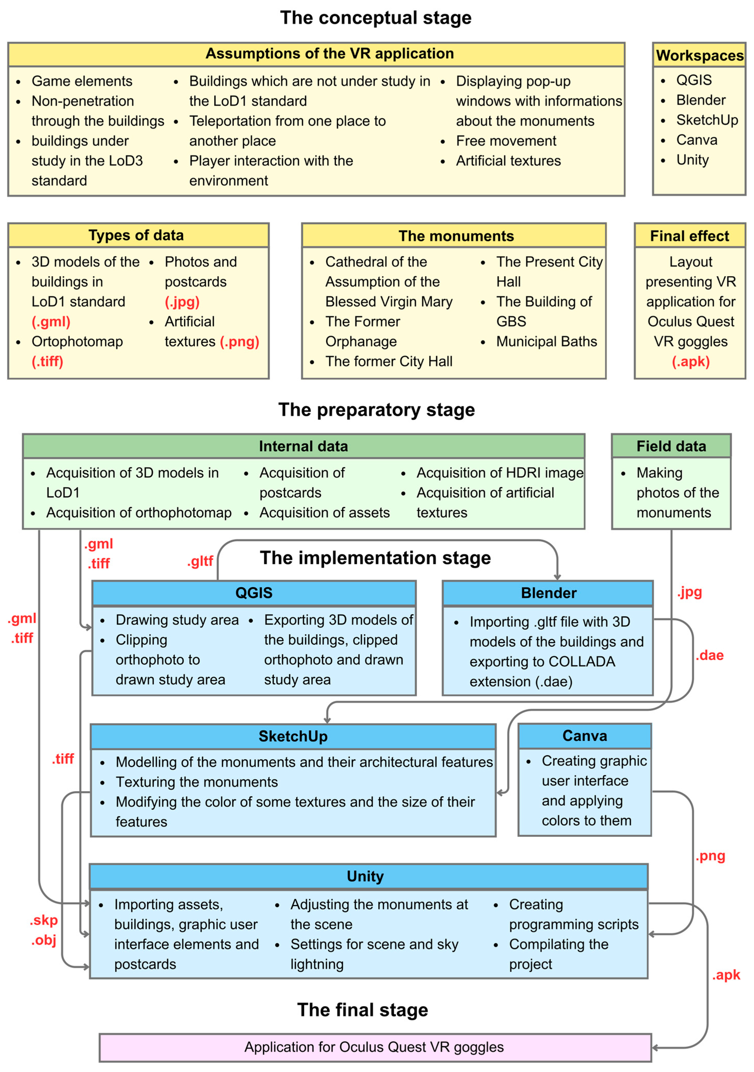
The methodological framework of the study was organized into four stages: the conceptual stage, the preparatory stage, the implementation stage, and the publication and evaluation stage (Figure 2). A research procedure diagram was prepared to define the sequence of activities. In the conceptual stage, the assumptions of the VR application, the software environment, and the expected final output were defined. The preparatory stage focused on data acquisition, while the implementation stage covered activities performed in individual workspaces. The final stage concerned the presentation of the completed application and its evaluation in relation to other forms of presenting the cultural heritage of Gorzów Wielkopolski.
Several design assumptions were adopted at the outset. The VR application was intended to include game elements based on collecting postcards assigned to six 3D models of the monuments and gaining points for selecting them correctly, as well as providing information about the monuments to familiarize users with the city’s cultural heritage. Users were not allowed to enter the buildings. The selected monuments were modelled in the LoD3 standard, whereas the remaining buildings within the scene were represented in the LoD1 standard. Navigation within the virtual environment was based on teleportation points, although users were also able to move freely within the accessible area and interact with the surroundings. Additional assumptions included the use of pop-up windows describing the monuments based on the available literature on the city, a points-based reward system, and the creation of seven stations, one of which was dedicated to the total score achieved by the player. Artificial textures were applied to the 3D models in order to obtain a coherent visual effect within the virtual environment.
Figure 2 also shows the practical relationships between the data, software, and output formats used in the project. The diagram makes clear that the development of the VR application required several transitions between geospatial processing, 3D modelling, graphic design, and game-engine implementation. Spatial data prepared in QGIS formed the base of the virtual scene, while Blender and SketchUp were used to convert, refine, and texture the building models. Interface elements prepared in Canva, together with postcards, models, assets, and textures, were finally integrated in Unity. In this way, the diagram presents not only the order of work, but also the technical dependencies between the different project components. This makes the proposed workflow easier to understand and potentially adaptable for similar cultural heritage visualisation projects.

3.4. Technical Workflow of 3D Modelling and VR Implementation

After data acquisition, the LoD1 3D building models and the orthophotomap were imported into a new QGIS 3.28 project in the PL-1992 coordinate system. A new polygon Shapefile layer in the same projection was then created, and a polygon defining the extent of the scene was drawn. The orthophotomap was clipped to this extent and saved in .tif format. The Qgis2three.js plugin was installed and used to generate an initial 3D scene, with both the clipped scene layer and the LoD1 building layer activated. The resulting scene was exported in .gltf format. In this stage, the orthophotomap served as the geovisualization base on which the player would later move within the VR application.
The exported .gltf buildings were subsequently imported into Blender and re-exported in .dae format. Separate SketchUp 2023 projects were then created for each of the six monuments, together with one additional project for the remaining buildings imported from Blender. The LoD1 models were used as the geometric basis for the more detailed modelling of the selected monuments. Each LoD1 building was copied into its corresponding SketchUp project, and the acquired photographs were fitted to the model in order to support the reconstruction of architectural details. Between two and six photographs were used for each monument, depending on the size of the building and the number of details requiring modelling. The largest number of photographs was required for the Municipal Baths and the Cathedral of the Assumption of the Blessed Virgin Mary, whereas the Former Orphanage required the fewest.
The modelling process began with simpler elements, such as rectangular and circular windows and wall extrusions. More complex features, including chimneys and roof elements, were modelled in the later stages. Once all monument models had been completed, they were textured in SketchUp using artificial textures imported into the software. In order to reproduce the actual appearance of the buildings as closely as possible, the colours and the dimensions of selected textures were modified. In total, 15 textures were adjusted.

4. Results

4.1. Developed VR Scene and Modelled Monuments

The main outcome of the study is an immersive VR application with game elements designed for headset-based interaction and tested on Quest 3 devices. The developed scene represents the selected part of the centre of Gorzów Wielkopolski and combines a geovisualization base derived from spatial data, LoD1 background buildings, and six manually modelled monuments prepared in SketchUp. The user can move freely within the accessible area of the scene, while collisions prevent movement through buildings and beyond the intended boundaries of the virtual environment.
The final scene includes both the preserved monuments selected for the study and the surrounding urban context. The case-study buildings were modelled with a higher level of detail than the remaining buildings, which function as the spatial background of the application. Artificial textures were applied to the monument models in order to achieve a coherent visual appearance in VR. In addition, environmental assets such as trees, flowers, bushes, and benches were introduced to increase the realism of the urban scene. Their placement was based on field photographs collected during the site inventory.
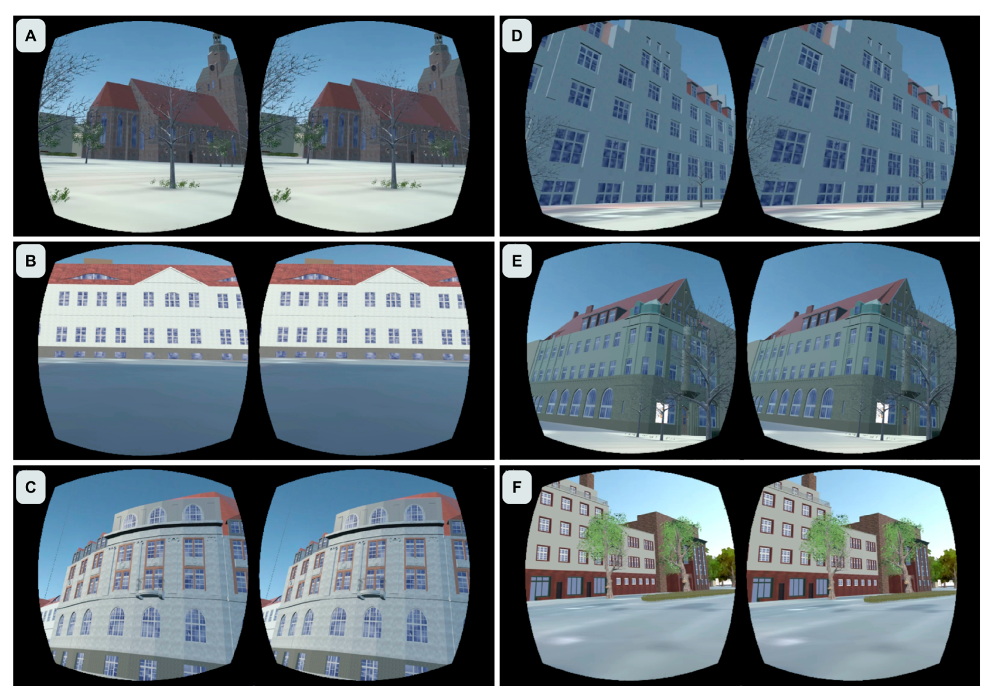
The completed virtual environment therefore combines three layers: the geodata-based spatial framework, the reconstructed 3D models of selected monuments, and interactive game-related elements. As a result, the scene is not limited to static visualization but functions as an explorable heritage environment. In the virtual environment, the following historical sites are located there, shown in Figure 3: The Cathedral of the Assumption of the Blessed Virgin Mary (A), The Former Orphanage (B), The Former City Hall (C), The Present City Hall (D), The Building of GBS (E) and Municipal Baths (F).

4.2. User Interface

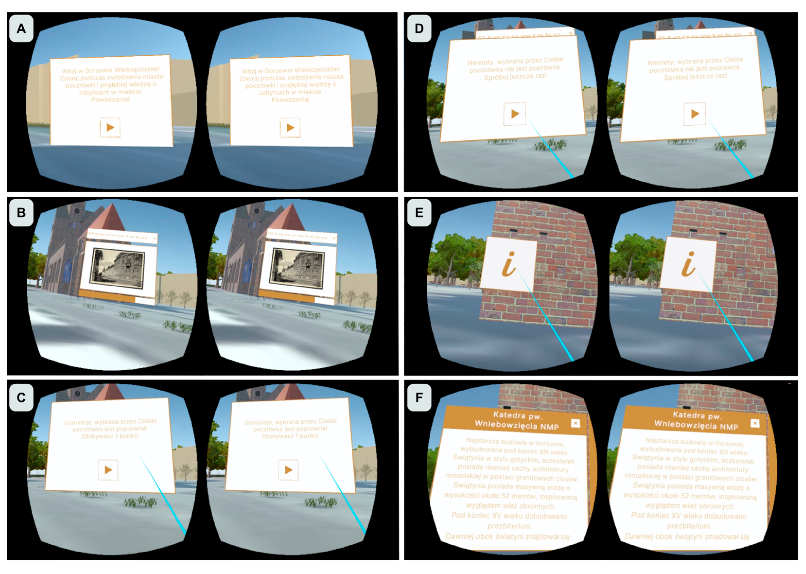
The user interface was designed as a set of panels supporting navigation, interpretation, and gameplay. At the beginning of the experience, the player is presented with a welcome panel that introduces the application and can be closed by pressing the continue button. After this initial interaction, the panel disappears and the user enters the main scene.
For each monument, an information button opens a dedicated panel containing descriptive content about the building. These panels include the monument name, a close button, and a vertical scrolling function for longer texts. Additional interface elements were designed for postcard selection, feedback messages, and score presentation. A single visual template was used across different interface components in order to maintain consistency.
User interface are shown in Figure 4. The interface therefore consists of: the welcome panel (A), postcard panels (B), feedback windows for correct (C) and incorrect choices (D), continue buttons, close buttons, information button (E) with monument information panels (F), and a final score window.
The final user interface was designed to support straightforward interaction while preserving the exploratory character of the application. It combines interpretive content with game-related feedback and makes the educational layer of the VR experience accessible without interrupting navigation through the virtual environment.

4.3. Game Mechanics: Postcards, Scoring, Teleportation

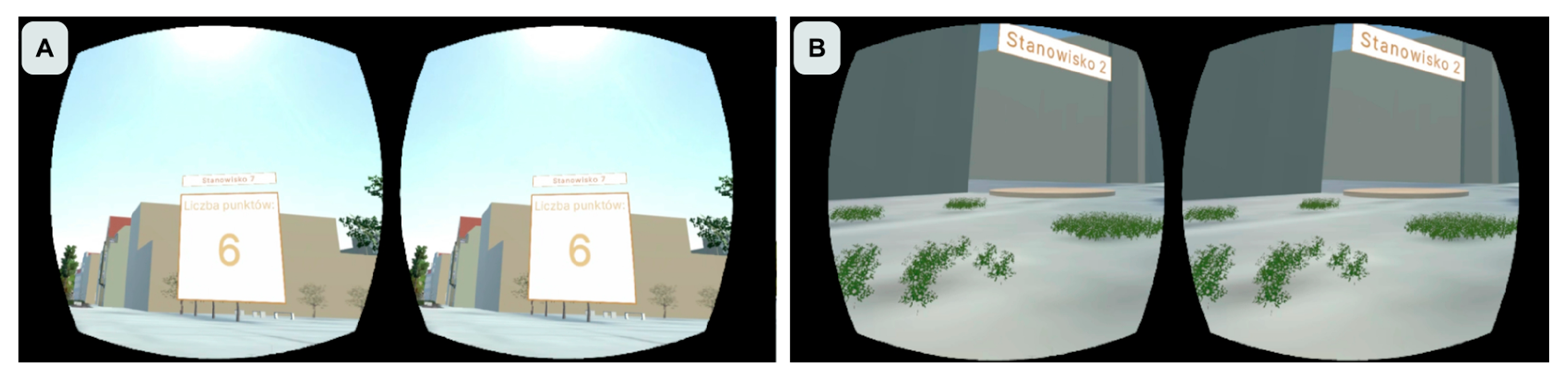
The application uses postcard selection as its core game mechanic. At each monument station, the player can locate a panel containing six postcards and must choose the one correctly associated with the monument present in the scene. If the correct postcard is selected, a feedback panel appears informing the player of the correct answer and awarding one point. If an incorrect postcard is chosen, the player receives a message indicating an incorrect selection and is encouraged to try again. The mechanics of the game are shown in Figure 5.
The scoring system (A) was implemented as a cumulative mechanism in which one point is awarded for each correct postcard. The player’s total score is presented at the final station. This design introduces a simple reward structure while maintaining the interpretive character of the application. The game therefore links visual recognition of heritage objects with historical imagery in the form of postcards.
A second important mechanic is teleportation between stations (B). The next teleportation point becomes available only after a correct answer has been given at the current station. This solution introduces a sequential progression structure and ensures that the player engages with each monument before moving to the next location. The final score station becomes visible after the correct completion of the sixth monument task.
An additional mechanic was introduced through the visibility of postcard panels. These panels appear only when the controller cursor is positioned in the appropriate area above the ground and disappear when the cursor is directed at the ground surface. This was intended to make discovery slightly less immediate and to encourage more active exploration of the scene.
The final application consists of a complete VR scene integrating heritage visualization, user interface elements, and game mechanics into a single interactive environment. From the user’s perspective, the experience begins with the welcome panel, followed by free exploration of the virtual area. At each monument, the player can open an information panel, search for the postcard panel, select an answer, receive immediate feedback, and unlock the next teleportation point after a correct choice.
The final views of the application therefore include: the opening screen, the general urban scene with LoD1 background buildings and detailed monuments, monument information panels, postcard selection panels, feedback windows for correct and incorrect answers, teleportation points between stations, and the final score window. Together, these elements form a playable VR heritage application that combines spatial exploration, monument interpretation, and a simple points-based task structure.
The player can see a total of six monuments and has the opportunity to read the information about them that has been posted on 6 separate panels, located nearby each monument. In total, he can score a maximum of 6 points for correctly identifying postcards on the 6 panels. For building the panels with the postcards, 6 postcards for each panel were chosen. For each correct postcard on every postcard panel, a message panel has been assigned to confirm the correct selection, which appears when the correct postcard is clicked. For the remaining five postcards, a message has been added to inform the player of an incorrect selection, which appears when an incorrect postcard is selected. The player has the opportunity to use 6 teleportation points that appear on the screen after the confirmation panel closes. Then, 7 stations with a panel containing number of the station were created, of which 6 stations were postcard stations, while one station displayed the points earned by the player.
A video presenting the development process and functionality of the application was published on YouTube [39]. It begins with the data acquisition and selection stage, followed by a presentation of the 3D building models, the orthophotomap, and the study area delineated in QGIS 3.28. The subsequent stage demonstrates the modelling and texturing of the monuments in SketchUp 2023, resulting in six completed and textured 3D models. This is followed by the user interface design stage, during which all interface components are presented. The video then shows the development of the VR application in Unity 2022.3.10f1, including the placement of the monuments within the scene, the creation of the postcard panels, and the implementation of barriers designed to prevent players from leaving the designated area.
The final part of the video presents the application testing process using a VR headset. First, the welcome panel is displayed and closed by the player using the controller and the “Continue” button. Next, the information panel is presented. By selecting the information button with the VR controller, the player opens a vertically scrollable panel containing information about the Cathedral of the Assumption of the Blessed Virgin Mary and closes it using the corresponding button. The video then demonstrates how the player selects a postcard at the station assigned to the cathedral. After the correct postcard is chosen, a feedback panel confirming the correct answer is displayed. Once this panel is closed, a teleportation point leading to the next station becomes visible. The player is subsequently shown exploring the scene, viewing the cathedral tower and the complete structure of the building, and using teleportation to move quickly to the next location. The final sequence presents the spatial arrangement of the monuments within the VR environment.

4.4. Survey

The survey was conducted among students between 10 and 14 July 2026 using an online questionnaire created in Google Forms. The questionnaire comprised 14 closed-ended, single-choice questions. Six questions focused specifically on the geovisualization aspects of the application and were accompanied by approximately 20 s video recordings demonstrating the VR application during tests performed with a VR headset. After viewing each video, participants evaluated the presented elements using a five-point Likert-type scale with the following response options: “yes,” “rather yes,” “neither yes nor no,” “rather no,” and “no.” Responses were coded from 1 (“no”) to 5 (“yes”), and the six evaluative Likert-type items showed modest internal consistency (Cronbach’s α = 0.61), which may reflect their coverage of several distinct aspects of the application.
The remaining questions collected sociodemographic and background information, including participants’ age, gender, level of education, place of residence, frequency of video game use, average number of hours spent playing video games per week, and previous experience with VR equipment. The questionnaire is available online at: https://docs.google.com/forms/d/e/1FAIpQLSf_0ETgcsamAI49sjR2JJwBhd97Z7muMAcV-vlVZqhVMYtopA/viewform?fbzx=-5345848732472683290, accessed on 14 July 2026.
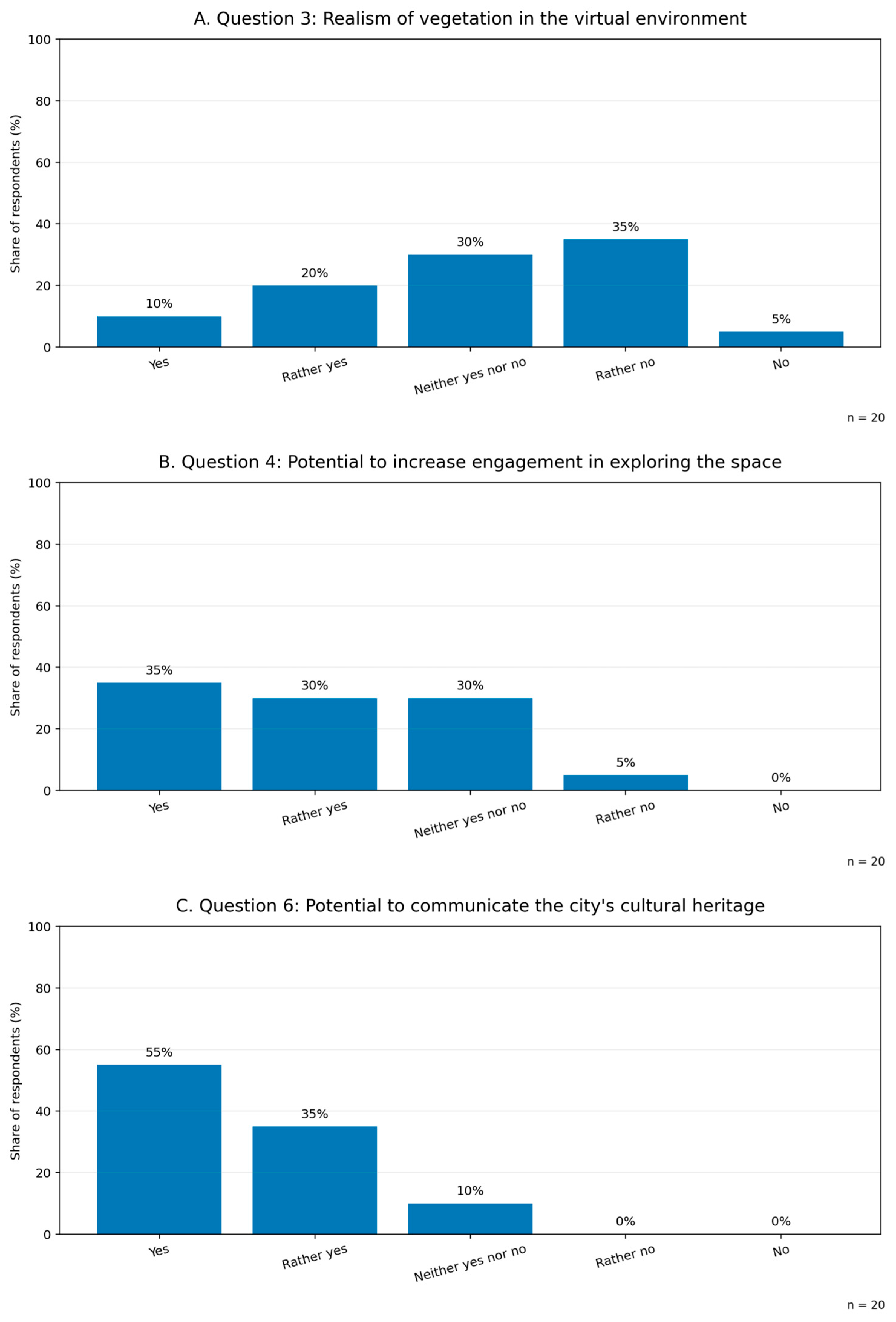
The survey results indicate an overall positive assessment of the immersive VR geovisualization by the 20 participating students. The sample was evenly divided by gender, consisted predominantly of participants aged 18–24 years (80%), and included 55% of respondents with previous experience using VR equipment. A total of 95% of respondents agreed or rather agreed that the application could accurately represent the dimensions of the visualized objects, while 90% positively evaluated their overall appearance. The strongest educational result concerned the application’s potential to support learning and memorization of information about the city’s cultural heritage, which was positively assessed by 95% of respondents. Similarly, 90% believed that the VR geovisualization could effectively communicate the history of the city’s cultural heritage. The relatively short descriptions of each historical site also contribute to this high rating. The use of exploration and postcard-collection mechanisms was also evaluated favorably, with 65% of respondents indicating that these elements could increase engagement, although 30% remained neutral. The least favorable results concerned the realism of vegetation: only 30% provided a positive response, whereas 40% assessed this aspect negatively and 30% selected the neutral option. Overall, the findings suggest that the application has considerable potential as an educational and heritage-presentation tool, although the natural environment—particularly vegetation—requires further visual refinement. The three selected charts (Figure 6) present the most relevant findings: the application’s principal value for communicating cultural heritage, its potential to engage users, and the main area requiring improvement.

5. Discussion

The application, implemented and tested on Meta Quest 3 devices, combines spatial exploration with postcard-matching tasks, scoring mechanisms, and teleportation-based navigation. This interaction model demonstrates that even relatively simple game mechanics can effectively structure user experience and support engagement without the need for complex gameplay systems. In contrast to many virtual heritage applications focused primarily on visualization or reconstruction, the presented approach introduces a lightweight interactive structure based on task completion and reward. This observation is consistent with studies indicating that basic game design elements, including points and feedback, are sufficient to increase motivation and support learning processes [22,24]. At the same time, the structure of the application remains oriented toward interpretation rather than entertainment, positioning it closer to a gamified educational tool than to a fully developed serious game. At the current stage, the solution can be most accurately described as a gamified immersive heritage application with educational intent.
The survey findings provide preliminary empirical support for these observations. Most respondents positively assessed the application’s ability to represent the dimensions and appearance of the visualized objects, communicate the history of the city’s cultural heritage, and support learning and memorization. The results also indicate that the postcard-collection and exploration mechanisms may enhance engagement, although the comparatively weaker assessment of vegetation realism identifies an important area for further visual improvement.
An important aspect of the study is the integration of heterogeneous data sources within a structured workflow, combining geodata, orthophotography, field documentation, archival materials, and 3D modelling into a single virtual environment. The adopted pipeline, based on widely available tools such as QGIS, SketchUp, and Unity, confirms that the development of immersive heritage applications is feasible without highly specialized or proprietary technologies. Similar approaches have been highlighted in previous research as effective for combining spatial data with interactive visualization environments [12,25]. However, the study also confirms that manual modelling and data preparation remain the most time-consuming stages, particularly when dealing with complex architectural forms and limited source materials. The most demanding stage was manual 3D modelling, especially in the case of buildings with complex roof geometries, arched windows, and ornamental details. Additional challenges resulted from field photography in dense urban environments, limitations in available viewpoints, and the alignment and adjustment of textures to achieve a credible visual representation. These constraints are consistent with broader observations in geovisualization research, where data processing and model generalization remain key challenges [1].
The proposed solution contributes to addressing a gap in the literature related to the limited number of applications that combine immersive VR environments with game-based interaction in the context of cultural heritage. The presented application demonstrates that such integration can be achieved in a relatively simple yet conceptually consistent way, particularly when interaction mechanisms are directly linked to the interpretation of heritage objects. The use of historical postcards as interactive elements introduces a temporal dimension, connecting past and present representations of the city and enriching the interpretive layer of the application. The case study of Gorzów Wielkopolski further demonstrates the applicability of this approach in urban environments where only fragments of historical heritage have been preserved, and where digital reconstruction and interpretation can support wider dissemination and accessibility.
At the same time, several limitations should be acknowledged. Although the survey provided an initial evaluation of users’ perceptions, its small sample size and video-based assessment procedure limit the generalizability of the findings. In addition, the VR application was evaluated without comparison with alternative forms of heritage presentation, such as traditional 2D maps, photographic materials, or on-site visits; therefore, the findings reflect participants’ perceptions of the application in isolation rather than its relative effectiveness compared with other approaches. The study did not include direct measurement of knowledge acquisition, task performance, usability, or prolonged interaction with the application; therefore, further evaluation involving hands-on VR testing and a larger, more diverse sample is required. Previous research emphasizes the importance of user studies in validating both immersive environments and gamification strategies [23]. Furthermore, the relatively simple interaction model may limit long-term engagement and replicability, particularly for users accustomed to more advanced digital experiences. The level of visual realism, dependent on manual modelling and available textures, may also influence the perceived authenticity of the virtual environment. These findings indicate that while the proposed workflow is accessible and feasible, it remains resource-intensive and strongly dependent on data quality and modelling complexity, which may limit scalability in larger or more detailed urban contexts.
Despite these limitations, the study demonstrates that a gamified immersive heritage application can serve as a meaningful medium for the communication and interpretation of local urban heritage. By linking spatial exploration with interactive tasks and historical materials, the application extends traditional forms of heritage presentation and offers a more engaging and accessible experience, particularly for audiences familiar with digital and game-based environments.

6. Conclusions

The results of this study demonstrate that the integration of geovisualization, virtual reality, and selected game-based interaction mechanisms can form a coherent and effective approach to the presentation of cultural heritage [9]. The novelty of the project lies not in individual components, but in their integration within a geodata-driven urban heritage context. The developed application confirms that immersive environments enhance spatial understanding and user engagement, particularly when interaction is directly linked to the explored environment. The ability to navigate a virtual urban space, interact with objects, and receive immediate feedback supports both exploratory behaviour and cognitive involvement, which are essential for meaningful user experience in virtual environments [5,11].
The questionnaire results further support this conclusion, as the majority of respondents positively evaluated the application’s potential to communicate cultural heritage, facilitate learning, and encourage engagement with the virtual urban environment. The study addressed both research questions formulated in the Introduction. First, it demonstrated that geovisualization, virtual reality, and gamification can be integrated into a coherent urban heritage application through a structured workflow combining geospatial data, 3D modelling, archival materials, game-engine implementation, and interactive tasks. Second, the questionnaire results indicated that the developed application was positively perceived in terms of its potential to support engagement, spatial understanding, and the communication and memorization of cultural heritage information. However, the findings also identified areas requiring further development, particularly the visual realism of vegetation and the need for direct user testing with VR headsets. At the same time, the lower ratings assigned to vegetation realism demonstrate that the visual quality of environmental elements remains an important direction for further development.
A significant conclusion from the conducted research is the need to incorporate appropriately developed texts into the presentation of cultural heritage objects. In our case, the texts were as short as possible and dedicated to the so-called public user, i.e., those with general knowledge [40]. A survey conducted for our study shows that users rated the communication potential of short texts highly (question 6 in the survey). Another conclusion is the need for labor-intensive manual steps in object modeling, despite the numerous existing digital modeling operations.
Future research should focus on three main directions. First, the preliminary survey should be extended through direct, hands-on testing with VR headsets and a larger and more diverse group of participants in order to assess usability, engagement, knowledge acquisition, and learning outcomes more comprehensively. Second, the applied technological framework should be examined in terms of usability, performance, and comparison with alternative approaches to immersive heritage visualization. Third, the role of individual gamification elements, such as scoring systems, feedback mechanisms, and interaction design, should be analysed more systematically. From the application perspective, further development may include the expansion of the number of heritage objects, the introduction of multilingual content, particularly in English and German, the addition of extended visual materials such as photo galleries, and further improvements in realism and interaction design.

Author Contributions

Conceptualization, N.W. and B.M.-G.; methodology, N.W. and B.M.-G.; software, N.W.; validation, N.W., B.M.-G. and Ł.H.; formal analysis, N.W. and B.M.-G.; investigation, N.W., B.M.-G. and Ł.H.; resources, N.W., B.M.-G., Ł.H. and A.M.; data curation, N.W.; writing—original draft preparation, N.W., B.M.-G. and A.M.; writing—review and editing, N.W., B.M.-G., A.M. and Ł.H.; visualization, N.W.; supervision, N.W., B.M.-G., Ł.H. and A.M.; project administration, A.M.; funding acquisition, A.M. and N.W. All authors have read and agreed to the published version of the manuscript.

Funding

This research was funded by IGiK Statutory Research Fund, No. D/2025/FBW/8 (“Geowizualizacja wybranych zabytków w Gorzowie Wielkopolskim w wirtualnej rzeczywistości z elementami gamingu”).

Data Availability Statement

The raw data supporting the conclusions of this article will be made available by the authors on request.

Conflicts of Interest

The authors declare no conflicts of interest.

Abbreviations

The following abbreviations are used in this manuscript:
3DThree dimensional
BIMBuilding Information Modelling
GISGeographic Information System
HCIHuman–Computer Interaction
HDRIHigh Dynamic Range Image
LoD1Level of Detail 1
LoD3Level of Detail 3
VRVirtual Reality

References

  1. Fitzpatrick, M.; Hedley, N. Review of the state of practice in geovisualization in the geosciences. Front. Earth Sci. 2024, 11, 1230973. [Google Scholar] [CrossRef] [Scilit]
  2. Krassanakis, V.; Skopeliti, A.; Keskin, M.; Cybulski, P. Geovisualization: Current Trends, Challenges, and Applications. Geographies 2023, 3, 801–805. [Google Scholar] [CrossRef] [Scilit]
  3. Mądrzak, O. Raport z analizy potencjału turystycznego miasta Gorzowa Wielkopolskiego i powiatu gorzowskiego. Tur. Kult. 2025, 3, 149–183. [Google Scholar] [CrossRef] [Scilit]
  4. Halik, Ł.; Kent, A.J. Measuring user preferences and behaviour in a topographic immersive virtual environment (TopoIVE) of 2D and 3D urban topographic data. Int. J. Digit. Earth 2021, 14, 1835–1867. [Google Scholar] [CrossRef] [Scilit]
  5. Slater, M.; Sanchez-Vives, M.V. Enhancing Our Lives with Immersive Virtual Reality. Front. Robot. AI 2016, 3, 74. [Google Scholar] [CrossRef] [Scilit]
  6. Kersten, T.P.; Tschirschwitz, F.; Deggim, S. Development of a Virtual Museum Including a 4D Presentation of Building History in Virtual Reality. In Proceedings of the ISPRS—International Archives of the Photogrammetry, Remote Sensing and Spatial Information Sciences, Nafplio, Greece, 1–3 March 2017; Copernicus Publications: Göttingen, Germany, 2017; Volume XLII-2/W3, pp. 361–367. [Google Scholar] [CrossRef] [Scilit]
  7. Slater, M. Immersion and the illusion of presence in virtual reality. Br. J. Psychol. 2018, 109, 431–433. [Google Scholar] [CrossRef] [Scilit] [PubMed]
  8. Medyńska-Gulij, B. Pragmatics of visual variables in statistical-thematic and immersive geovisualizations. Int. J. Cartogr. 2025, 11, 282–287. [Google Scholar] [CrossRef] [Scilit]
  9. Bekele, M.K.; Champion, E. A comparison of immersive realities and interaction methods: Cultural learning in virtual heritage. Front. Robot. AI 2019, 6, 91. [Google Scholar] [CrossRef] [Scilit] [PubMed]
  10. Tutzauer, P.; Becker, S.; Haala, N. Perceptual Rules for Building Enhancements in 3D Virtual Worlds. I-Com 2017, 16, 205–213. [Google Scholar] [CrossRef] [Scilit]
  11. Theodoropoulos, A.; Antoniou, A. VR Games in Cultural Heritage: A Systematic Review of the Emerging Fields of Virtual Reality and Culture Games. Appl. Sci. 2022, 12, 8476. [Google Scholar] [CrossRef] [Scilit]
  12. Laksono, D.; Aditya, T. Utilizing A Game Engine for Interactive 3D Topographic Data Visualization. ISPRS Int. J. Geo-Inf. 2019, 8, 361. [Google Scholar] [CrossRef] [Scilit]
  13. Anderson, E.F.; McLoughlin, L.; Liarokapis, F.L.; Peters, C.; Petridis, P.; De Freitas, S. Developing serious games for cultural heritage: A state-of-the-art review. Virtual Real. 2010, 14, 255–275. [Google Scholar] [CrossRef] [Scilit]
  14. Kersten, T.; Tschirschwitz, F.; Deggim, S.; Lindstaedt, M. Step into Virtual Reality-Visiting Past Monuments in Video Sequences and as Immersive Experiences. In Latest Developments in Reality-Based 3D Surveying and Modelling; MDPI Books: Basel, Switzerland, 2018; pp. 192–219. [Google Scholar] [CrossRef] [Scilit]
  15. Carbonell-Carrera, C.; Saorin, J.L.; Melián Díaz, D. User VR Experience and Motivation Study in an Immersive 3D Geovisualization Environment Using a Game Engine for Landscape Design Teaching. Land 2021, 10, 492. [Google Scholar] [CrossRef] [Scilit]
  16. Khan, N.; Rahman, A.U. Rethinking the mini-map: A navigational aid to support spatial learning in urban game environments. Int. J. Hum.–Comput. Interact. 2018, 34, 1135–1147. [Google Scholar] [CrossRef] [Scilit]
  17. Anwar, M.S.; Yang, J.; Frnda, J.; Choi, A.; Baghaei, N.; Ali, M. Metaverse and XR for cultural heritage education: Applications, standards, architecture, and technological insights for enhanced immersive experience. Virtual Real. 2025, 29, 51. [Google Scholar] [CrossRef] [Scilit]
  18. Zagata, K.; Gulij, J.; Halik, Ł.; Medyńska-Gulij, B. Mini-Map for Gamers Who Walk and Teleport in a Virtual Stronghold. ISPRS Int. J. Geo-Inf. 2021, 10, 96. [Google Scholar] [CrossRef] [Scilit]
  19. Pagano, A.; Palombini, A.; Bozzelli, G.; De Nino, M.; Cerato, I.; Ricciardi, S. ArkaeVision VR Game: User Experience Research between Real and Virtual Paestum. Appl. Sci. 2020, 10, 3182. [Google Scholar] [CrossRef] [Scilit]
  20. Zawadzki, J.; Medyńska-Gulij, B. Landscape Reconstruction with Earth-and-Timber Medieval Stronghold—Immersive Geovisualization. Land 2024, 13, 1323. [Google Scholar] [CrossRef] [Scilit]
  21. Mortara, M.; Catalano, C.E.; Bellotti, F.; Fiucci, G.; Houry-Panchetti, M.; Petridis, P. Learning cultural heritage by serious games. J. Cult. Herit. 2014, 15, 318–325. [Google Scholar] [CrossRef] [Scilit]
  22. Wang, H.; Gao, Z.; Zhang, X.; Du, J.; Xu, Y.; Wang, Z. Gamifying cultural heritage: Exploring the potential of immersive virtual exhibitions. Telemat. Inform. Rep. 2024, 15, 100150. [Google Scholar] [CrossRef] [Scilit]
  23. Krath, J.; Schürmann, L.; Von Korflesch, H.F. Revealing the theoretical basis of gamification: A systematic review and analysis of theory in research on gamification, serious games and game-based learning. Comput. Hum. Behav. 2021, 125, 106963. [Google Scholar] [CrossRef] [Scilit]
  24. Sailer, M.; Hense, J.U.; Mayr, S.K.; Mandl, H. How gamification motivates: An experimental study of the effects of specific game design elements on psychological need satisfaction. Comput. Hum. Behav. 2017, 69, 371–380. [Google Scholar] [CrossRef] [Scilit]
  25. Ma, Y.-P. Extending 3D-GIS District Models and BIM-Based Building Models into Computer Gaming Environment for Better Workflow of Cultural Heritage Conservation. Appl. Sci. 2021, 11, 2101. [Google Scholar] [CrossRef] [Scilit]
  26. Franczuk, J.; Boguszewska, K.; Parrinello, S.; Dell’Amico, A.; Galasso, F.; Gleń, P. Direct use of point clouds in real-time interaction with the cultural heritage in pandemic and post-pandemic tourism on the case of Kłodzko Fortress. Digit. Appl. Archaeol. Cult. Herit. 2022, 24, e00217. [Google Scholar] [CrossRef] [Scilit]
  27. Geovisualization of Town Square in Walcz Using Unreal Engine with Gaming Features. Available online: https://www.youtube.com/watch?v=0EekIE4TfiA (accessed on 13 July 2026).
  28. Medyńska-Gulij, B. Kartografia Geomatycznie i Geomedialnie; Wydawnictwo Naukowe PWN SA: Warszawa, Poland, 2024. [Google Scholar]
  29. Dębska, A. Krajobraz kulturowy Gorzowa Wielkopolskiego. Renowacje I Zabyt. 2023, 3, 52–75. [Google Scholar]
  30. Linkowski, Z. Gorzów Gotycki. Księga Pamiątkowa Miasta Gorzowa Wielkopolskiego; Urząd Miejski, Wydział Kultury w Gorzowie Wlkp: Gorzów Wielkopolski, Poland, 2000; pp. 50–51. [Google Scholar]
  31. Piotrowski, R. Historie w kamienicy Lamus–ostatnie 80 lat, a może nieco więcej, może trochę dalej. In 80 Lat Kamienicy; Klub Myśli Twórczej “LAMUS”: Gorzów Wielkopolski, Poland, 2011; pp. 7–23. [Google Scholar]
  32. Piotrowski, R. Od Starego Rynku… Czyli Rzecz o Placach Gorzowa; Stowarzyszenie Promocji Kultury Kamienica: Gorzów Wielkopolski, 2016; pp. 3–4. [Google Scholar]
  33. Garbacz, K. Przewodnik po Zabytkach Województwa Lubuskiego. Tom III; Agencja Wydawnicza “PDN”: Zielona Góra, Poland, 2013. [Google Scholar]
  34. Skaziński, B. Prace w kościele katedralnym pw. Wniebowzięcia NMP w Gorzowie Wlkp. In Lubuskie Materiały Konserwatorskie. Tom 15; Wojewódzki Urząd Ochrony Zabytków w Zielonej Górze: Zielona Góra, Poland, 2018; pp. 77–80. [Google Scholar]
  35. Wykaz Obiektów Wpisanych do Rejestru Zabytków. Available online: https://bip.um.gorzow.pl/499/Wykaz_obiektow_wpisanych_do_rejestru_zabytkow/ (accessed on 26 February 2026).
  36. Zarządzenie nr 240/I/2018 Prezydenta Miasta Gorzowa Wielkopolskiego z Dnia 21 Czerwca 2018 r. Zmieniające Zarządzenie w Sprawie Przyjęcia Gminnej Ewidencji Zabytków Miasta Gorzowa Wielkopolskiego. Available online: https://bip.um.gorzow.pl/system/obj/20825_ZPM-240-I-2018.pdf (accessed on 26 January 2026).
  37. geoportal.gov.pl. Available online: https://mapy.geoportal.gov.pl/imap/Imgp_2.html?gpmap=gp0 (accessed on 13 July 2026).
  38. Biblioteka Cyfrowa WiMBP Gorzów Wielkopolski. Available online: https://dlibra.wimbp.gorzow.pl/dlibra?language=pl (accessed on 13 July 2026).
  39. Geovisualization of Selected Monuments in Gorzów Wielkopolski in VR with Gaming Elements. Available online: https://www.youtube.com/watch?v=1iB_f4wwY9c (accessed on 3 April 2026).
  40. Halik, Ł.; Wielebski, Ł. Usefulness of Plane-Based Augmented Geovisualization—Case of “The Crown of Polish Mountains 3D”. ISPRS Int. J. Geo-Inf. 2023, 12, 38. [Google Scholar] [CrossRef] [Scilit]
Figure 1. Location of Gorzów Wielkopolski in Europe and location of the monuments in Gorzów Wielkopolski shown against an OpenStreetMap background.
Ijgi 15 00344 g001
Figure 2. Research procedure diagram of VR application. The stages are highlighted in different colors, and the file formats used in the project are highlighted in red. The arrows indicate the import of data in a given format from one software to another software.
Ijgi 15 00344 g002
Figure 3. The Monuments in VR application layout: The Cathedral of the Assumption of the Blessed Virgin Mary (A), The Former Orphanage (B), The Former City Hall (C), The Present City Hall (D), The GBS building (E) and Municipal Baths (F).
Ijgi 15 00344 g003
Figure 4. User interface in VR application: the welcome panel described “Welcome to Gorzów Wielkopolski! Collect postcards during exploring the city and learn more about the monuments. Good luck!” (A), postcard panel with number of the station (station 2) (B), feedback windows for correct choice described “Congratulations! The postcard you chose is correct! You earn 1 point!” (C) and incorrect choices described “Unfortunately, the postcard you selected is incorrect. Please try again!” (D), an information button (E) with monument information panels about the Cathedral of the Assumption of the Blessed Virgin Mary, described as “The oldest building in Gorzów, constructed at the end of the 13th century. It is a Gothic-style church, though it also features elements of Romanesque architecture in the form of granite blocks. The church has a massive tower 52 meters high, inspired by the design of defensive towers. The chancel was added at the end of the 15th century.” (F).
Ijgi 15 00344 g004
Figure 5. The game mechanics: scoring system with number of the station (station 7) and number of points (A) and teleportation station with number of the station (station 2) (B).
Ijgi 15 00344 g005
Figure 6. Respondents’ assessments of selected aspects of the immersive VR geovisualization: (A) realism of vegetation in the virtual environment, (B) potential to increase engagement in exploring the space, and (C) potential to communicate the city’s cultural heritage (n = 20).
Ijgi 15 00344 g006
Table 1. Monuments included in the study and their status in the Register of Monuments and the Municipal Register of Monuments.
Name of the MonumentThe Entry in the Register of MonumentsThe entry in the Municipal Register of Monuments
Cathedral of the Assumption of the Blessed Virgin MaryYesYes
The Former OrphanageYesYes
The Former City HallYesYes
The Present City HallNoYes
The Building of GBSYesYes
Municipal BathsYesYes
Disclaimer/Publisher’s Note: The statements, opinions and data contained in all publications are solely those of the individual author(s) and contributor(s) and not of MDPI and/or the editor(s). MDPI and/or the editor(s) disclaim responsibility for any injury to people or property resulting from any ideas, methods, instructions or products referred to in the content.