Abstract
With rapid population growth, there is an increasing demand for vertical use of space. The wide spread of complex and high-rise buildings, as well as the increasing number of infrastructure above or underground, requires new methods for efficient management of land property. 3D cadastre has, thus, become a necessity for land administration. However, the success of 3D cadastral systems relies on the definition of legal and institutional frameworks and requires implementing performant technical solutions. The potential of BIM and 3D GIS in this field has been demonstrated by several authors. However, cadastral development is strongly related to the national context of each country in terms of laws, institutions, etc. In this paper, an integrated approach based on BIM and 3D GIS for the implementation of a 3D cadastre in Morocco is presented. This approach demonstrates the relevance of such integration for the efficient management of cadastral information. First, a Conceptual Data Model (CDM) based on an extension of CityGML, was proposed for the management of cadastral information in Morocco. Then, a BIM modeling process was developed according to the model’s specifications and then translated to CityGML format. After that, a 3D Geodatabase was implemented in ArcGIS based on the proposed CDM. Our method was applied to a case of co-ownership building, showing several difficulties and limits in terms of 2D representation. The results show several advantages in terms of representation and management of 3D cadastral objects. In addition, some improvements are proposed to extend the concept of co-owner share to a volumetric calculation.
1. Introduction
Nowadays, the increasing pressure on land use and the growing rate of urbanization has led to stratified constructions with complex structures. Currently, there is a tendency for vertical and multiple use of space, e.g., vertical constructions belonging to several owners, infrastructure above or underground (Figure 1), overlay between public properties (such as roads, bridges and monuments) and private ones, increasing number of cables and pipes, etc. [1].
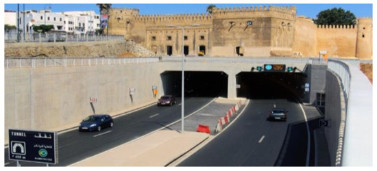
Figure 1.
The “Oudaya” Tunnel in Rabat (Morocco).
While the current legislation provides an institutional background for the legal registration of properties and rights, traditional cadastral systems suffer from an inefficient management of complex situations. In fact, with multiple use of space (complex buildings and stratified properties above and underground), 2D cadastre systems reach their limits and cannot fully reflect the 3D spatial extent of properties and visualize spatial information in a clear and illustrative way [2,3]. The traditional cadastre is based on a division of land into 2D parcels. Ownership and limited real rights are often listed on these parcels as complementary information. While these rights have a vertical dimension and are delimited in height and depth, their representation is essentially in 2D.
Current practices in the registration and management of stratified property rights are based on two-dimensional subdivision plans. These plans do not effectively represent property spaces within complex situations (high-rise buildings, tunnels and utilities, underground infrastructures, etc.). Furthermore, the spatial complexity of 3D property spaces associated with irregular physical structures within buildings may not be effectively mapped through their projection into horizontal and vertical planes. The cadastre should therefore be extended to the 3D space to accurately represent stratified properties and rights, above or below a certain parcel [2].
The developments in 3D Geographic Information Systems (GIS), as well as in Building Information Models (BIM), propose innovative methods for 3D geometric and semantic modeling of urban space. Both systems propose appropriate methods with demonstrated potential in representing the geometry and semantics of 3D objects. 3D GIS can be used to capture the geometry and topological relationship of 3D cadastral objects. In addition, it allows structuring semantic information about these cadastral objects in a relational 3D spatial database. On the other hand, BIM is considered an object-oriented process, which describes buildings in respect to their geometric and semantic properties. It therefore allows the generation and management of spatial modeling of physical and functional characteristics of building spaces and their surrounding environments [4]. Beyond visualization purposes, BIM is characterized by a clear and logical structure of spatial objects of a building enabling to have spatial analyses [5]. High possibilities resulting from the use of BIM for presentation and management of 3D cadastral information have been investigated by several scholars: [5,6,7].
This paper proposes an approach for 3D cadastre based on the integration of BIM and 3D GIS, which is illustrated by a case study about the Moroccan context. The objective is to establish a proof of concept towards the adoption of a 3D cadastre in Morocco. The paper is organized as follows: In Section 2, previous research works addressing 3D cadastre solutions based on BIM and/or 3D GIS are presented and discussed. In Section 3, the integrated BIM-3D GIS approach for 3D cadastre in Morocco is presented. In Section 4, the application of a case study of co ownership is detailed. Section 5 brings general discussion about the achievements and limits of the proposed approach. Finally, the paper ends with a general conclusion.
2. Related Work
3D cadastre allows 3D representation and management of legal information about RRRs (Rights, Restrictions, and Responsibilities) and their corresponding physical models, such as buildings, on, under or at the ground level [8]. Several authors have demonstrated the benefits of 3D cadastre. Besides, several academic and professional groups are leading research in this context. The working group on “3D Cadastres”, under the FIG (International Federation of Surveyors) committee, is tracking and publishing relevant realizations in 3D cadastre worldwide. Their recent report, published in 2018, is a relevant reference about some worldwide best practices of 3D cadastre [9].
More particularly, some researchers have investigated the use of BIM and 3D GIS for developing cadastral approaches. Developments in the context of BIM have proposed extensions of the IFC (Industry Foundation Class) standard to represent cadastral concepts [10], while 3D GIS-based approaches have adopted the CityGML standard to provide an environment for 3D spatial analysis [11]. In the next subsections, we give an overview about the main developments in the context of 3D cadastre based on BIM and/or 3DGIS.
2.1. Importance of 3D Cadastre
Compared to the actual 2D cadastral system, 3D cadastre facilitates the management of property rights and urban spaces in a consistent way. It allows functions of 3D data storage, 3D visualization, and 3D spatial analysis [1]. However, the efficient management of complex situations of ownership and other RRRs is not trivial. It requires a clear definition of the concept of 3D property, often used as a general comprising term whose definition is context based, as well as clear procedures for 3D property delimitation and registration [5]. 3D registration provides the possibility to make clear and simple, the representation of properties and rights in the 3D space. Alternatively, this delimitation has to be reconstructed via several 2D drawings, cross-sections, and verbal descriptions [12], which is an inconsistent manner to represent cadastral situations. Figure 2 shows an example of the delimitation of the right of “houa” in the Moroccan cadastre using a text description. The right of “houa” refers to the right to use the space (volume) above a registered parcel or a building.
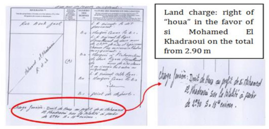
Figure 2.
Verbal description of the right of “houa” in a sketch of demarcation.
Although the 2D cadastral registration may be sufficient for representing some property situations where the vertical component is neither important nor complex, the problem arises in 3D property situations in which different ownership units (with different types of land use) are superimposed or built in even more complex structures. In 3D property situations, several users use a quantity of space (volume) delimited in three dimensions. These volumes are positioned on top of each other, either all in the same base plot (in the same parcel column defined by the boundaries at the surface) or crossing the boundaries of the base plots. Real rights are then established to allow different people to access the different volumes. However, in some areas where the built environment is not complex (e.g., rural areas with agricultural land and forests), traditional 2D cadastral plans are still appropriate for land tenure security, land-use planning, as well as for supporting spatial development and decisions [13].
Finally, 3D cadastre is needed as an innovative solution to ensure an efficient representation of land properties and a good management of stratified land Rights, Restrictions, and Responsibilities (RRR). Indeed, the main objective of a cadastre is to represent legal spaces that are related to a real estate property. However, in order to better understand the extent of these legal spaces, 3D cadastre digitally represents their physical counterparts (such as buildings, utilities, on, above, or below the ground surface) in a 3D environment. 3D cadastre allows associating both the representation of a 3-dimensional reality and the access to complete and organized georeferenced data in a continuously updated database. However, 3D cadastral systems add more complexity and require more development in terms of technical solutions by integrating new technologies that have changed the way surveyors are collecting cadastral data. The development of 3D cadastre should consider technical, legal, and institutional aspects in an integrated framework [14]. Furthermore, the difficulty of handling the transition between the actual and the future system should not be neglected.
Standardization is an important process to ensure a smooth transition between 2D and 3D cadastre. According to the best of our knowledge, there is no specific standard dedicated to 3D cadastre. However, an important contribution in the land and urban administration is the Land Administration Domain Model (LADM) of ISO 19152. This standard is not dedicated to 3D cadastre, but can be adopted to model the 3D property and the semantic information associated with RRRs [5]. The LADM standard provides a formal conceptual model for recording and managing land administration data [15]. It provides an extensible basis for the development and refinement of efficient and effective land administration systems [16]. With the increasing need of 3D cadastral information, LADM has been widely used to support 3D representations of spatial units without adding any additional burden on the existing 2D representations. The use of LADM for cadastral purposes has been addressed by several authors: [5,8,16,17,18,19].
2.2. BIM for 3D Cadastre
The prolific increase in 3D models describing the physical reality of our world provides a good opportunity for cadastral systems to shift from 2D to 3D information environments [16]. An important research trend is the increasing creation and use of BIM in the cadastre. Indeed, BIM contains accurate geometry data and building information, which can support the management of land and property information in high-rise buildings [20,21]. The linkage between BIM and 3D cadastre is a new research area that has become a focus of various investigations. High possibilities resulting from the use of BIM for 3D cadastre were investigated by several authors: [5,6,22]. More specifically, the IFC standard for BIM can provide detailed and rich physical information of a building, which can be exploited for linking 3D cadastral information to the physical world models [22]. BIM does not consider special dedicated object classes for recording data in accordance to the requirements of the cadastre [23]. However, some researchers point out some possible ways to overcome this problem by using IFC universal classes (so-called “virtual spaces”) [22]. Indeed, the use of space and zone concepts in IFC could be a suitable approach to provide virtual legal spaces in BIM [7] which can be used for modeling cadastral ownership units [23].
More recent studies have implemented BIM models to showcase the feasibility of using BIM for managing 3D cadastral information [3,7,21]. For instance, [22] introduced a new approach of obtaining 3D data from BIM for 3D cadastre use. Their approach is based on the implementation of cadastral requirements in the stage of the building design. According to the authors, extraction of legal spaces from BIM models at the end of the design process is facilitated. In the same research trend, [5] showed possibilities of introducing legal space units of the Sweden 3D cadastre during the construction process of complex buildings. The author of [21] introduced a BIM-based approach for modeling building ownership boundaries within a BIM environment. The authors proposed an extended IFC standard to manage, record, and visualize 3D legal boundaries and ownership arrangements in the context of the Victoria State of Australia. Recently, [24] presented a solution for extending the IFC standard with 3D cadastral information. The authors used some concepts of IFC standard: “IfcSpace” and “IfcZone” for modeling cadastral ownership. These concepts have been also adopted by [7]. “IfcSpace” is an entity that is used for representing volumetric functional spaces inside a building, while a set of “IfcSpace” instances is arranged into an “IfcZone” to define a specific ownership arrangement (Figure 3).
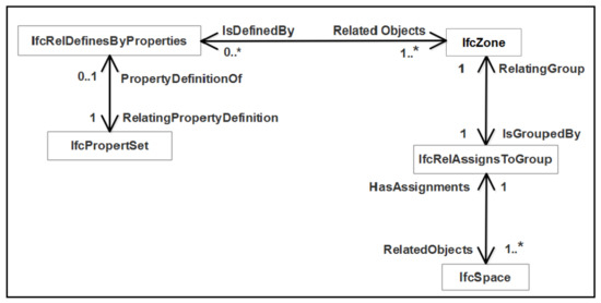
Figure 3.
IFC extension model for 3D cadastre [7].
Another study of [10] demonstrates the feasibility of using BIM for 3D digital management of ownership rights, through a prototype BIM model, where two types of ownership spaces, including private spaces and common property areas, are created by utilizing the “room” capability in Revit. The authors first identified the required elements for managing data related to 3D RRR spaces and then proposed an IFC extension to deal with the defined concepts. The viability of the extension was demonstrated through a case study of a multi-storey building to showcase how 3D digital data, associated with various complex ownership spaces, can be visualized and managed. The prototype model is exported in IFC format and then imported into Solibri Model Viewer, which provides 3D visualization of ownership spaces. Another investigation by [21] consists of developing an IFC extension for 3D cadastre, to illustrate how the elicited 3D RRR data elements can be appropriately embedded into the BIM environment. 3D RRR concepts are extended to model 3D RRR information with an IFC extension. The spatial and physical entities adopted for 3D RRR data management in the IFC scheme are presented in Figure 4. The relevant ones for 3D cadastre are: ifcBuilding, ifcBuildingStorey, ifcSlab, ifcWall, and ifcSpace. The author of [21] proposed a second solution to extend the IFC standard to determine whether BIM can be adopted to support 3D land administration. To enrich the IFC data model with legal information, the necessary legal entities were identified. The main legal entities identified in [25] have been adopted as those required for managing legal information. These entities include 3D legal property objects, different types of legal documents, and interest holders. Each of these entities should be appropriately defined within the IFC data model and this requires selecting proper IFC entities to define relationships between them and legal entities.
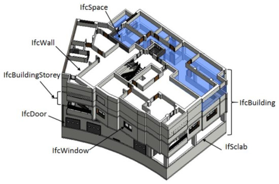
Figure 4.
Relevant IFC spatial and physical entities for 3D Cadastre (inspired from [25]).
To sum up, we can say that BIM is a potential solution for modeling 3D cadastre concepts. Indeed, the generic aspect and “universal classes” defined in the IFC scheme allow adapting the IFC model for utilization in a cadastral context [7]. Investigations show that developing extensions of IFC is a practical way to profit from IFC model in 3D cadastre developments.
Certainly, BIM allows 3D modeling of physical and cadastral concepts of buildings. However, it scores low when considering spatial queries and analysis. It seems obvious as long as the development purpose behind BIM is to respond to specific needs on 3D modeling of the building element properties with precise geometry and rich semantics. As the cadastre is intended to deal with spatial queries about properties, their extents, and associated rights, research was directed to the contribution of 3D GIS in 3D cadastre, particularly by investigating the potential of CityGML in this context. The next subsection presents the main notable developments in this context.
2.3. 3D GIS for 3D Cadastre
3D cadastre should represent 3D geometries of cadastral objects and handle their spatial relationships in a 3D space. Certainly, BIM gives a useful framework for 3D modeling of cadastral information through its IFC standard. However, BIM is not suitable for visualizing and analyzing the 3D cadastre at the city level [3], unless it lacks functionality of data query and large spatial simulations. Since 3D GIS was designed for spatial analysis and decision-making, its utilization in 3D cadastre is highly justified to deal with the need of spatial query about cadastre ownership and extraction of common and private rights. 3D GIS proposes appropriate methods to represent the geometry and topology of 3D cadastral objects and associate them with semantics about property rights; all this information can be organised in a 3D cadastral database.
As an international standard for 3D city modeling, CityGML provides a flexible conceptual model, which can be adapted to land administration domain, particularly for supporting the spatial concepts required for cadastral systems [26]. CityGML is an XML-based open standardized geometry model, which supports storage and exchange of 3D spatial data effectively. The CityGML specification is commonly used to represent the semantic and geometric properties of 3D city models for several applications, such as urban planning, 3D cadastre, facility management, and environmental simulations [27]. To support additional requirements by certain use cases, CityGML 2.0 developed a built-in mechanism ADE (Application Domain Extension), which can be utilized for cadastral applications [28]. Recently, a new version of CityGML 3.0 is proposed for better interoperation with other standards like IFC, LADM, and IndoorGML [27]. CityGML 3.0 adds several changes, improvements, extensions, and new modules such as the “Core” package and the “Building” package.
Several investigations tend towards exploring the potential of CityGML for 3D cadastre applications. Furthermore, integration of BIM and GIS is the subject of many publications (e.g., [29,30]). Several researchers have investigated the possibility of using CityGML associated with LADM standard for 3D cadastre purpose. Particularly, the study of [3] focused on designing, implementing, and evaluating a method to link legal cadastral information in LADM to 3D models of physical spaces (IFC and CityGML models), to support visualization and analysis of the cadastral information. The author of [17] studied the possibilities of using CityGML for 3D cadastre. Their investigation confirmed that CityGML provides a flexible conceptual model, which can be adapted for supporting the spatial concepts required for cadastral systems. To overcome the difficulties in introducing elements representing non-spatial components of land administration, the proposal of adding semantic representations for land administration within CityGML was recommended through a CityGML-LADM ADE. The author of [17] implemented a CityGML-LADM ADE for cadastre in the Netherlands. Furthermore, [19] proposed an ADE of CityGML to incorporate all possible legal data into the existing building model and another class to represent apartments in the building. The author of [19] developed a CityGML-LADM ADE where the integration of the LADM model and CityGML is done at the conceptual level. Their approach provides an overview of the spatial extent of 3D plots and helps to understand the location of property boundaries. In addition, [31] propose a 3D cadastral data model (3DCDM) as a solution capable of supporting 3D data, integrating 3D physical objects with their corresponding 3D legal objects, and featuring semantically enriched objects. The 3DCDM model represents 3D legal objects and connects them with physical objects. In this regard, the 3DCDM model is equipped with the concepts of Legal Property Object (LPO) and Physical Property Object (PPO). The former facilitates modeling of all existing interests (RRR) as legal objects, while the later considers all 3D urban features such as buildings, tunnels, and utilities as physical objects. This model supports the semantics that define every aspect of legal and physical objects and therefore facilitates their integration.
2.4. Discussion
BIM is based on a knowledge-rich parametric modeling of building elements, which allows and facilitates the creation of a rich building model. Moreover, BIM is considered as an object-oriented process that describes buildings according to their geometric and semantic properties. This involves the generation and management of numerical spatial representations of the physical and functional characteristics of building spaces and their environment [4]. However, BIM is not capable of recording and representing ownership and property boundaries, which is essential information for land administration [5]. In addition, BIM does not have spatial analysis capabilities, and for this reason, its data is incorporated as an entry into 3D GIS to support spatial relationships. Although IFC has a rich semantic representation of building elements in a building, it does not explicitly model topology such as neighbourhood relationships. This makes it difficult to automate the process of creating 3D cadastral objects from IFC models.
On the other hand, 3D GIS have great potential to integrate new information, in addition to analyzing and querying spatial and attribute data, which allows the user to extract information about the land title, such as its number, volume, and its owner. 3D GIS offers great possibilities to manage, analyze, and query spatial data in relation to BIM but in contrast, some technical issues about BIM and 3D GIS integration are to be addressed. Their architecture can be very powerful for performing hierarchical and advanced thematic analysis. In this respect, 3D GIS would be a good solution for the representation, registration, and management of different legal information associated to cadastral location. Besides, the CityGML standard offers great potential for interoperability with external databases (i.e. cadastral databases, addresses, etc.). Such flexibility allows CityGML to be adopted in several applications, including land registry applications [32]. Another potential of CityGML is its web-sharing capabilities. For instance, [33] developed a Web3DGIS system to display and query CityGML templates on the web. However, one of the major problems of today’s 3D GIS solutions is their limited capabilities of drawing, editing, and rendering complex 3D models compared to BIM software.
Several studies have highlighted the need to integrate BIM and 3D GIS to capitalize on their strengths and to overcome their weaknesses [34,35,36]. Ref. [37] developed an extension of an intermediate UBM (Unified Building Model), which combines IFC and CityGML to support 3D cadastre applications. However, the proposed approach remains at the conceptual level and does not explain the details and challenges of such integration.
BIM and 3D GIS have been developed independently to serve different purposes about urban modeling and 3D simulations. However, there is some overlap between BIM and CIM (City Information Modeling) because both domains are used for modeling buildings and constructions. While BIM focus on modeling indoor elements of a building, 3D GIS models the building in the city environment to consider its interaction with the other elements of the city. Furthermore, BIM scores well in modeling and representing the geometry of building compounds accurately, while the GIS basic function is spatial data query and visualization. Thus, the integration of these two domains is a way to capitalize on their advantages and to overcome the limitations of each one. However, this is not a trivial task because of interoperability problems.
The integration of BIM and 3D GIS is largely based on the exchange of data between the two systems. Among the proposed approaches, the transformation between IFC and CityGML is adopted as a solution for semantic mapping between the two schemas. The conversion of BIM data to 3D GIS has shown a growing interest in several applications such as urban planning, 3D cadastre [38,39]. Particularly, [40] developed an automatic method for conversion from IFC to CityGML Lod3. Recently, [38] developed a method to formalize the geometric aspects of the integration between BIM and 3D GIS. In this transformation, we have to deal with interoperability problems. For instance, IFC geometry uses CSG (Constructive Solid Geometry) modeling with volumetric parametric primitives representing the structural components of buildings. However, the CityGML standard uses surface representations (B-REP: Boundary REPresentation). This paradigm creates a high combinatorial complexity in the transformation. Added to this, there is some discordance in mapping semantic classes due to the difference of the level of detail between the two standards. Hence, despite the existing efforts, interoperability between BIM/IFC and GIS/CityGML is far from being reached.
Finally, adopting an integrated BIM–3D GIS approach for 3D cadastre would help to fill the gaps between the two approaches and to take advantage of their benefits. In the next section, a BIM-3D GIS integrated approach is proposed to provide a relevant solution for the representation, management, and registration of cadastral data in the Moroccan context.
3. Methods
In the previous sections, we highlighted how CityGML and IFC have been used for 3D cadastre purposes. Our investigations of the literature have shown that, because of their different development purposes, CityGML and IFC present some limitations when dealing with cadastral concepts and are likely to be integrated to propose adequate models for 3D cadastre. Therefore, the purpose of our research is to propose an integrated approach based on BIM and 3D GIS for 3D cadastre in Morocco. Although 3D cadastre is not yet on the agenda of the Moroccan cadastre agency, this research will raise awareness about 3D cadastre in Morocco and bring a proof of concept for its adoption.
The methodology includes six main stages (Figure 5): (1) Definition of a CDM (Cadastre Data Model) for 3D cadastre; (2) design of a BIM model according to the specifications and requirements of the adopted CDM; (3) conversion of IFC data to CityGML; (4) database implementation based on the proposed CDM; (5) application of the approach to a co-ownership case study; and (6) quality assessment.
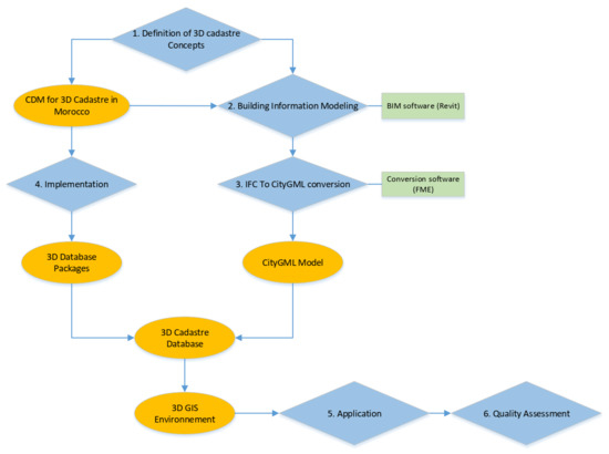
Figure 5.
Main stages of the methodology.
Cadastre systems have to deal with many aspects, including legal, institutional, and technical [14]. At the technical level, 3D Modeling is a major milestone for the implementation of a 3D cadastre. A 3D cadastral model should basically ensure exploring and visualizing the different parts of the building units (objects, elements, attributes, and constraints), serving as a basis for cadastre databases and supporting a clear representation for cadastral properties.
In the Moroccan context, ANCFCC (National Agency for Land Registration, Cadastre, and Cartography) is the governmental administration responsible for cadastre management. This is a major positive point until the cadastral database is handled by one actor. The actual cadastral system in Morocco is based on 2D registration of objects by assigning 2D geometry to each parcel. In the case of situations where the property extent is vertical (co-ownership), complementary vertical profiles assigning heights to each apartment are annexed to the cadastral plan. Each property title can be the object of subsequent cadastral operations, which should be managed and registered in a consistent way.
As discussed in the previous sections, there is a need to extend the CityGML standard to fully support 3D cadastral applications that go beyond spatial considerations, particularly those related to the representation of legal information that deals with ownership and RRR in general. For this purpose, some additional classes should be linked to CityGML to model the legal ownership and the administrative operations. More specifically, the model should associate 3D physical objects with their corresponding legal definitions.
For a consistent modeling of the cadastre system, we consider two types of information: (1) legal property in terms of extents and rights, and (2) cadastral operations subsequent to cadastral registration. Therefore, two main concepts are considered: “Physical object” and “Legal object”. While the former is used for modeling the physical characteristics of properties (building, building parts, parking, etc.), the later represents legal property limits and rights associated to each ownership property. The differentiation between the two concepts is justified by the fact that in some situations, the legal definition is not equal to the physical one, particularly when the building construction part does not entirely cover the property parcel. Hence, the proposed model is composed of three packages: “Physical package”, “Legal package”, and “Administrative package”:
- The physical package consists of CityGML classes on which we add an abstract class of the physical property, named “cadastral object”, which makes a link between the legal and the physical classes
- The legal package captures the legal concepts of 3D cadastre through the following classes:
- “Legal object”: this class represents each legal interest associated to a spatial extent. We define a legal interest as a material benefit (private area in a co-ownership) or a moral interest (right of easement). Thus, a legal object can be a 3D parcel, a property, a common part, an easement, etc. Each legal object is linked to a “parcel”
- A “cadastral object” is an abstract class, which is the base class for the legal package
- A “parcel”: is a class that represents the property volume defined according to the rules of the urban legislation
- A “property holder” is a physical/moral person who holds an interest associated to a legal object
- “Property Title”: each legal object is associated to one title or several registered sub-titles
- “Cadastral mark”: the cadastral limits of each parcel
The “Administrative Package” contains the “cadastral operation” class, which represents the cadastral operations associated with each parcel. Finally, the proposed model of 3D cadastre in Morocco is based on the schema of the “Building” Module of CityGML, which is extended by the classes defined in the “Legal Package” and the “Administrative Package” (Figure 6).
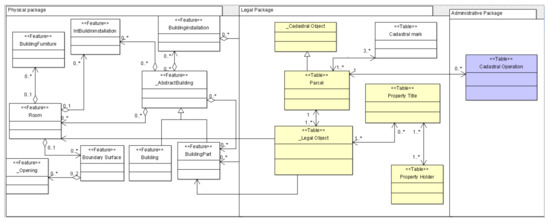
Figure 6.
CityGML extension for the Cadastre Data Model.
A 3D cadastral database based on the CityGML scheme implementing the previous CDM is created; a BIM model for a cadastral situation is developed and then integrated to a 3D GIS environment after conversion between IFC and CityGML. Furthermore, we have to deal with the technical problems about integration between IFC and CityGML in order to map the concepts between both schemas.
4. Application
The proposed method described in the previous section was implemented in a real cadastral situation as a proof of concept for 3D cadastre in Morocco.
4.1. The Cadastral Situation
To implement and validate the proposed approach, the case study consists of a co-ownership building composed of a ground floor with two accesses (one for residential apartments and another for commercial shops), a parking space in the underground, three residential floors, and a terrace (Figure 7). The building is composed of 23 private areas and 7 common ones. The choice of this case study is justified by the complexity and ambiguity of correctly describing the extent of the building parts and the corresponding rights through 2D plans. The application tackles the case of co-ownership property, which is the most frequent and difficult cadastral situation in the actual cadastre in Morocco.
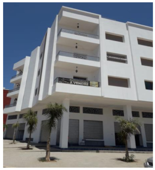
Figure 7.
The building co-ownership, object of the case study.
This cadastral situation presents some specific characteristics to be considered in the modeling process:
- A parking space is situated under the ramp of the parking space. The 2D representation associated to this situation shows the space and ramp in the same level with two different symbols (Figure 8a). With such a representation, the interpretation is difficult. An on-site visit was necessary to understand the situation represented by the 3D model in Figure 8b.
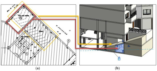 Figure 8. (a) A 2D representation of the ramp and the parking space; (b) the associated 3D model.
 - The shops are located on the ground floor and extend in height up to the first-floor level. This situation creates voids at the upper ground level, which are projected on 2D plans and designated by “Vide/Commerce” (Figure 9).
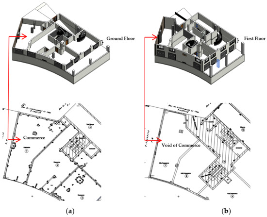 Figure 9. (a) The representation of commerce in 2D drawings (ground floor); (b) The representation of the void of commerce in 2D drawings (first floor).
 - This situation includes two RRRs: (a) a right-of-way easement represented by the arcade area located on the ground floor and extended to the first-floor level, and (b) a right of usage for a single co-owner, who exclusively benefits from the terrace. The 3D extent of the two rights are represented by Figure 10a,b.
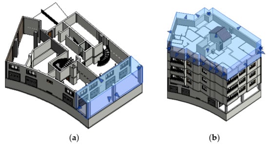 Figure 10. The 3D extent of: (a) the right-of-way easement; (b) the right of usage.
The cadastral situation described above is represented by 2D plans relative to each floor, where data about vertical heights is represented by an elevation graphic of the building (Figure 11).

Figure 11.
A vertical graphic of the building.
4.2. The Building Information Model
The process starts by integrating 2D CAD drawings in Revit software and then defining building levels according to the elevation of each part. This software was elected for BIM modeling as it is widely adopted as a performant tool for BIM. The modeling process was performed with regards to the specifications of the proposed CDM model for the 3D cadastre in Morocco. Indeed, the “IFC space” concept was used for modeling legal objects (Figure 12a) and the extent of rights: right-of-way easement and right of usage. The resulting BIM is then exported to IFC by adopting a configuration table to allow matching between Revit concepts (families) and IFC classes. During the export, we split elements by floor, which permits extracting apartments belonging to the same floor in a 3D GIS platform. Besides, the “quantities” option in the export configuration table is used to allow extraction of surfaces and volumes, to be adopted later for calculating co-ownership shares. The resulting Building Information Model is represented in Figure 12b.
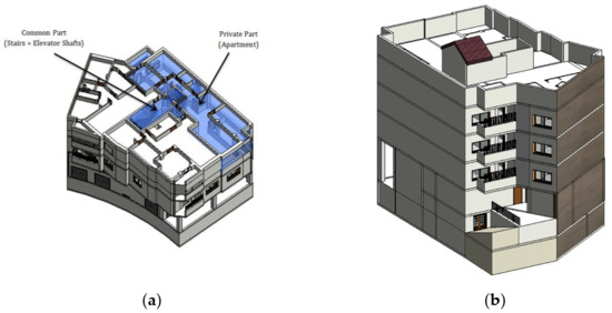
Figure 12.
(a) Representation of legal objects within BIM; (b) The resulting BIM textured in Revit.
4.3. CityGML Conversion
The resulting IFC is exported in a 3D GIS environment according the CityGML standard. The challenge is to conserve topological and structured information of the BIM model. To perform the translation task, FME (Feature Management Engine) was used. FME contains several transformers to allow a matching process between two different schemas (see the matching algorithm in Figure 12). The translation algorithm is composed of six main packages:
- -
- “Read source” package: This package is for data reading from the IFC model
- -
- “Group by CityGML feature types” package: It aims to group IFC elements into the corresponding CityGML classes
- -
- “Create building feature types”: In this package, the algorithm creates the geometry of building features
- -
- “Join with parent gml_id”: This package aims to join the building features with their building parent ID
- -
- “CityGML attributes, geometry traits and appearances”: The objective of this package is to populate the attributes and to define the appearance of building installations, building parts, roofs, walls, and floors
- -
- “Opening”: It creates the association between openings (doors and windows) and the corresponding walls. In addition, the attribute and appearance are generated for these openings
Afterwards, we associated a spatial reference system with the 3D model because it has only a relative reference system in the BIM environment. However, cadastral data should be georeferenced according to a national reference system to ensure full compatibility with existing cadastral data. The resulting model is then compatible with the CityGML standard with an associated reference national system (Merchich-zone1). It should be noted that before proceeding with the conversion of our model, it is essential to know first which building elements or packages of the IFC model are represented by a particular type of functionality of the CityGML document. Sometimes a CityGML entity type corresponds to more than one building element. In this case, they are merged under a common identifier (ID), which allows them to be routed together to the same entity type. For example, BuildingPart features are made up of many IFC feature types, such as BuilingColumn, BuildingElementProxy, and StairFlight (Figure 13).
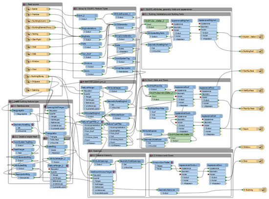
Figure 13.
FME algorithm for IFC To CityGML conversion.
4.4. Spatial Database Implementation, Data Query, and Calculation
The resulting CityGML model is exported to a Geodatabase created in ArcGIS software, thanks to FME software. Then, all semantic packages, illustrated in Figure 6, are added to this Geodatabase. This information is extracted from the 2D drawings and the co-ownership regulation of the building. The geodatabase resulting from the implementation of the CDM allows several functionalities useful for cadastral information handling. A basic function consists of the consultation and visualization of cadastral information about a property: title, holder name, surface, private/common areas, etc. (Figure 14).
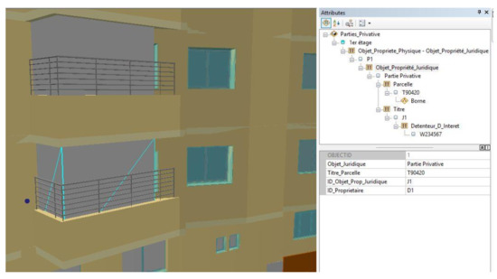
Figure 14.
Available information on a selected private area.
Soft transition between the current 2D cadastre and the future 3D cadastral system should be realized. The latter should allow the generation of 2D cadastral plans, which is actually a fundamental document in the cadastre administration. Our modeling process allows extraction of 2D plans representing each floor, in which we added layout specifications according to the formal specifications set by ANCFCC (Figure 15).
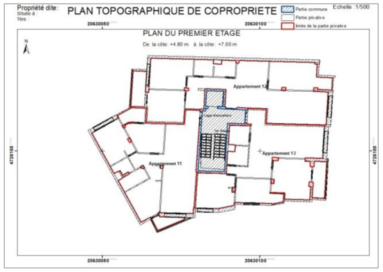
Figure 15.
An extracted 2D plan according the formal specifications of ANCFCC.
Moreover, we added a new functionality to the database relative to the co-ownership share. The “co-ownership share” is defined as the share of the common areas, services, and equipment of a property, allocated to each owner. It is often expressed in tenths or thousandths. The co-ownership share appears in the regulations of each co-ownership. It is used as a basis for the repartition of common expenses and private ones, relative to each owner. The concept is also extended to define the power to vote for each owner at the general meeting of co-owners. Its calculation is currently based on surface. This method does not reflect the real extent of each property and co-ownership values are so over- or under-estimated. Hence, to meet the purpose and requirements of the 3D cadastre, we should take into consideration the difference in height between levels and the case of private areas that cross several levels (for example: shop, mezzanine). Some international experiences highlight the importance of considering the different heights between levels in cadastral legislation [41]. Therefore, we propose a new concept, which is the “co-ownership-volume share”, which is calculated based on the volume of owner parts. It is defined as follows:
Co-ownership-volume share = Volume of the private part ∗ Total Surface of the Parcel/total of volumes of private parts
This equation is used to compare the results of the calculation based on the new method with those of the classical method. Table 1 highlights significant differences and shows cases of over- or under-estimation.

Table 1.
Comparison of co-ownership shares based on volume and surface.
4.5. Quality Assessment
After performing the data conversion process between BIM and GIS, the next step is validation of the coherence and completeness of the model in order to ensure that the interoperability between IFC and CityGML data models was fulfilled during the conversion process. The validation method is carried out according to two main phases: (1) Geometric Validation and (2) Semantic Validation. Identifying the errors in the CityGML output enables to determine and fix the issues in the input IFC model and the conversion workflow.
- Geometric validation
The geometric validation consists of verifying the geometric completeness and the correctness of the CityGML model resulting from the conversion process. To do so, the model was first imported into the FZK Viewer software to inspect the resulting IFC and CityGML models.
The FZK Viewer allows verifying the geometric completeness of the IFC model. Indeed, there are some minor inconsistencies between the BIM model created in Revit and the IFC model. For example, the “Flat Roof” entity in the former becomes “Slab” entity in the latter. Moreover, the IFC model lacks the building texture created in Revit.
Regarding the CityGML model exported from the IFC model, the inspection shows that some data is missing. For example, in the IFC Model, a building is divided into floors, and each floor is composed by spaces with the same elevation. The IfcBuildingStorey entity defines the building floor at a certain elevation, and generally represents a horizontal aggregation of vertically linked spaces. However, the concept of floors or spaces is not explicit in CityGML, where a building is composed of rooms bounded by different boundary surfaces. Thus, the information contained in the IfcBuildingStorey entity is missing in the conversion result.
- Semantic validation
This second phase of validation consists of analyzing the semantic coherence between the three models (BIM, IFC, and CityGML). In fact, some feature types cannot be mapped directly between IFC and CityGML [32], due to differences in semantics in the respective standards. Indeed, during the conversion between BIM and IFC models, we noticed that the information about the wall (available in the BIM model) is lost during the conversion process. In the IFC model, the information that has been reported is only related to the element name, object type, and ID. In addition, some semantic data is missing during the conversion between the IFC and CityGML Models. For example, the CityGML model does not take into account some semantic attributes, such as construction materials, maintenance status, etc. This can be explained by the fact that the CityGML standard is dedicated to 3D GIS applications and so does not consider this type of information.
5. Discussion
According to the literature, there are three main approaches for 3D cadastre [14]: “Fully 3D cadastre” where the legal basis and the cadastral registration should support the establishment and conveyance of 3D property and 3D rights; “Hybrid Cadastre” which is based on the preservation of the 2D cadastre and the registration of 3D situations within the 2D cadastral registration in which the explicit relationships between the parcels and the 3D objects are maintained; and finally “Cadastre with 3D tags”, which keeps the 2D parcels by adding labels on a digital map to mention to the user corresponding references to some documents containing 3D information, such as acts or plans. The hybrid solution seems to be the most appropriate approach in the Moroccan context. Under this approach, in urban areas, property rights, restrictions, and responsibilities are modeled in 3D and integrated into the 3D cadastral database. Otherwise, in rural areas and small urban centers, 2D representation of parcels would be maintained by default.
The management of stratified land’s RRRs is an important challenge for the current land administration and cadastre needs [31,42]. 3D cadastre is an active research trend. Despite the notable achievements, its development still faces many challenges to be fully adopted and generalized. We argue that there is no universal solution for 3D cadastre. Indeed, its development is context depending. Therefore, each country has to take into consideration its existing legislation and cadastral context to develop practical and efficient 3D cadastre solutions.
As stated before, Morocco is not yet engaging a strategy for developing 3D cadastre. The case study presented in this paper shows the interest and the necessity of migrating to a 3D cadastre in Morocco. The adopted method proposes a BIM modeling of the physical and legal objects, while semantic enrichment is performed through a CityGML extension. The representation of the legal objects of co-ownership is achieved by adopting the Revit’s «Space» concept. This allows a clear volumetric representation of the spatial extent of the property spaces. In addition, it offers the possibility to calculate the volume, the surface, and the height of the different property spaces in the BIM environment. In addition, it allows exporting all the calculated quantities in order to exploit them when integrating the 3D model in the 3D GIS software.
The proposed BIM-GIS 3D solution for 3D cadastre has demonstrated the advantage of linking spatial objects from the legal and physical world. Indeed, the integration of BIM and 3D GIS is largely based on the exchange of data between the two systems. However, the transformation of geometry from BIM (BIM) to CityGML (GIS) tends to generate geometric errors and cause loss of geometric information due to the extraction and simplification of data from one system to another.
The existing BIM-based approaches discussed in [5,7,20,21,24,43] have extended IFC classes to deal with cadastre concepts. In contrast, the proposed approach in this paper extends the capabilities of the IFC standard by its integration with CityGML standard. This integration was carried out by enriching the resulting model with new packages that are dedicated to cadastral concepts. The resulting database provides rich and consistent information to support 3D cadastral operations, particularly 3D visualization and querying of real situations without the need to visit the terrain or attach photos (which is a common practice to clarify some complex situations in the actual system). Furthermore, some of the works presented in this paper have proposed the use of 3D GIS-based approaches for 3D cadastre [3,17,19,26]. These studies focused on the design of databases and interoperability issues; they are mainly based on the use of LADM. However, the impact of these approaches on the co-ownership concept was roughly addressed. In our case, the use of a BIM-3D GIS approach allows carrying out spatial queries to extract relevant 3D cadastral information as shown in Figure 14. Besides, a new concept of ‘Co-ownership-volume share’ based on volume was introduced, which reflects the impact of considering 3D information in assessing the real extent of co-ownership shares. In addition, the developed application gives the possibility to extract 2D information, which has the advantage to make a soft transition between 2D and 3D cadastral systems.
Finally, our research outcomes can serve as a proof of concept to convince public actors about the usefulness of the development of 3D cadastre in Morocco.
6. Conclusions
Based on a deep literature review about the use of BIM and 3D GIS for 3D cadastre, we concluded that their integration could respond to 3D cadastre needs by taking benefits from both systems and overcoming their limits. We have, therefore, proposed our 3D BIM-GIS-oriented solution for the implementation of the 3D cadastre in Morocco. Our approach starts by proposing a 3D cadastre model and then develops a process based on BIM modeling, CityGML conversion of the resulting IFC and implementation of 3D Geodatabase in ESRI based on a semantic enrichment of the building module of CityGML. Our method is projected on a case study of a co-ownership building in order to demonstrate the feasibility of our approach and the applicability of the established model. This solution based on BIM-3D GIS makes it possible to improve management of cadastral information in Morocco.
At the technical level, it is interesting to highlight the major interoperability problem between BIM (IFC) and 3D GIS (CityGML). Indeed, loss of information occurs when exporting the IFC model to CityGML. It is interesting to study how the two standards can be better aligned to allow efficient data exchange. Therefore, future developments are needed to deal with interoperability problems.
As a future work, a deep analysis of the legal and institutional frameworks of the Moroccan cadastre must be carried out in order to assess its level of readiness for upgrading to a 3D cadastre. This will give a good basis for establishing legal and institutional recommendations to prepare the transition to a 3D cadastre. A fundamental step would be the adoption of the volume as the basic unit of registration of land ownership. In addition, some recent papers have shown the great potentials of Virtual Reality (VR) environments to improve user interaction with 3D models [44,45]. The research team will lead further investigations to study the opportunities provided by immersive VR environments to interact with the developed 3D GIS-BIM model for cadastral purposes.
Author Contributions
Conceptualization, Rafika Hajji and Reda Yaagoubi; funding acquisition, Ahmed EL Gholabzouri; methodology, Rafika Hajji, Reda Yaagoubi, Imane Meliana, and Imane Laafou; project administration, Rafika Hajji; resources, Ahmed EL Gholabzouri; supervision, Rafika Hajji and Reda Yaagoubi; validation, Rafika Hajji and Reda Yaagoubi; writing—original draft, Rafika Hajji; writing—review and editing, Reda Yaagoubi and Imane Meliana. All authors have read and agreed to the published version of the manuscript.
Funding
This research received no external funding.
Institutional Review Board Statement
Not applicable.
Informed Consent Statement
Not applicable.
Conflicts of Interest
The authors declare no conflict of interest.
References
- Stoter, J.; Salzmann, M. Towards a 3D cadastre: Where do cadastral needs and technical possibilities meet? Comput. Environ. Urban Syst. 2003, 27, 395–410. [Google Scholar] [CrossRef]
- Gulliver, T.; Haanen, A.; Goodin, M. A 3D digital cadastre for New Zealand and the international opportunity. ISPRS Int. J. Geo-Inf. 2017, 6, 375. [Google Scholar] [CrossRef]
- Sun, J.; Mi, S.; Olsson, P.O.; Paulsson, J.; Harrie, L. Utilizing BIM and GIS for Representation and Visualization of 3D Cadastre. Isprs Int. J. Geo-Inf. 2019, 8, 503. [Google Scholar] [CrossRef]
- Isikdag, U.; Zlatanova, S. A SWOT analysis on the implementation of Building Information Models within the Geospatial Environment. In Urban and Regional Data Management; CRC Press-Leiden: Ljubljana, Slovenia, 2009; pp. 15–30. [Google Scholar]
- El-Mekawy, M.; Paasch, J.M.; Paulsson, J. Integration of 3D cadastre, 3D property formation and BIM in Sweden. In Proceedings of the 4th International Workshop on 3D Cadastres, Dubai, United Arab Emirates, 9–11 November 2014; pp. 17–34. [Google Scholar]
- Shojaei, D.; Rajabifard, A.; Kalantari, M.; Bishop, I.D.; Aien, A. Design and development of a web-based 3D cadastral visualisation prototype. Int. J. Digit. Earth 2015, 8, 538–557. [Google Scholar] [CrossRef]
- Atazadeh, B.; Rajabifard, A.; Zhang, Y.; Barzegar, M. Querying 3D cadastral information from BIM models. ISPRS Int. J. Geo-Inf. 2019, 8, 329. [Google Scholar] [CrossRef]
- Pouliot, J.; Vasseur, M.; Boubehrezh, A. How the ISO 19152 Land Administration Domain Model performs in the comparison of cadastral systems: A case study of condominium/co-ownership in Quebec (Canada) and Alsace Moselle (France). Comput. Environ. Urban Syst. 2013, 40, 68–78. [Google Scholar] [CrossRef]
- Van Oosterom, P. Best Practices 3D Cadastres-Extended Version: International Federation of Surveyors (FIG); FIG Publication, International Federation of Surveyors: Copenhagen, Denmark, 2018. [Google Scholar]
- Atazadeh, B.; Kalantari, M.; Rajabifard, A. Comparing three types of BIM-Based Models for managing 3D ownership interests in multi-level buildings. In Proceedings of the 5th International FIG 3D Cadastre Workshop, Athens, Greece, 18–20 October 2016. [Google Scholar]
- Ying, S.; Guo, R.; Li, L.; He, B. Application of 3D GIS to 3D cadastre in urban environment. In Proceedings of the 3rd International FIG Workshop on 3D Cadastres: Developments and Practices, Shenzhen, China, 25–26 October 2012; pp. 25–26. [Google Scholar]
- Stoter, J.; Ho, S.; Biljecki, F. Considerations for a contemporary 3D cadastre for our times. Int. Arch. Photogramm. Remote Sens. Spat. Inf. Sci. 2019, 42, 81–88. [Google Scholar] [CrossRef]
- Drobež, P.; Fras, M.K.; Ferlan, M.; Lisec, A. Transition from 2D to 3D real property cadastre: The case of the Slovenian cadastre. Comput. Environ. Urban Syst. 2017, 62, 125–135. [Google Scholar] [CrossRef]
- Stoter, J.E.; van Oosterom, P. 3D Cadastre in an International Context: Legal, Organizational, and Technological Aspects; CRC Press: Boca Raton, FL, USA, 2006. [Google Scholar]
- Lemmen, C.; Van Oosterom, P.; Bennett, R. The land administration domain model. Land Use Policy 2015, 49, 535–545. [Google Scholar] [CrossRef]
- Rajabifard, A.; Atazadeh, B.; Kalantari, M. A critical evaluation of 3D spatial information models for managing legal arrangements of multi-owned developments in Victoria, Australia. Int. J. Geogr. Inf. Sci. 2018, 32, 2098–2122. [Google Scholar] [CrossRef]
- Góźdź, K.; Pachelski, W.; van Oosterom, P.; Coors, V. The possibilities of using CityGML for 3D representation of buildings in the cadastre. In Proceedings of the 4th International Workshop on 3D Cadastres, Dubai, United Arab Emirates, 9–11 November 2014; pp. 9–11. [Google Scholar]
- Cemellini, B.; van Oosterom, P.; Thompson, R.; de Vries, M. Design, development and usability testing of an LADM compliant 3D Cadastral prototype system. Land Use Policy 2020, 98, 104418. [Google Scholar] [CrossRef]
- Dsilva, M.G.; Speckmann, B.; Westenberg, M.A.; van Hee, K.M. A Feasibility Study on CityGML for Cadastral Purposes. Master’s Thesis, Eindhoven University of Technology, Eindhoven, The Netherlands, 2009. [Google Scholar]
- Atazadeh, B.; Kalantari, M.; Rajabifard, A.; Ho, S.; Ngo, T. Building information modelling for high-rise land administration. Trans. GIS 2017, 21, 91–113. [Google Scholar] [CrossRef]
- Atazadeh, B.; Kalantari, M.; Rajabifard, A.; Ho, S. Modelling building ownership boundaries within BIM environment: A case study in Victoria, Australia. Comput. Environ. Urban Syst. 2017, 61, 24–38. [Google Scholar] [CrossRef]
- Oldfield, J.; Van Oosterom, P.; Quak, W.; Van Der Veen, J.; Beetz, J. Can data from BIMs be used as input for a 3D Cadastre. In Proceedings of the 5th International FIG 3D Cadastre Workshop, International Federation of Surveyors (FIG), Athens, Greece, 18–20 October 2016; pp. 199–214. [Google Scholar]
- Gotlib, D.; Karabin, M. Integration of models of building interiors with cadastral data. Rep. Geod. Geoinform. 2017, 104, 91–102. [Google Scholar] [CrossRef]
- Rajabifard, A.; Atazadeh, B.; Kalantari, M. BIM and Urban Land Administration; CRC Press: Boca Raton, FL, USA, 2019. [Google Scholar]
- Atazadeh, B.; Kalantari, M.; Rajabifard, A.; Ho, S.; Champion, T. Extending a BIM-based data model to support 3D digital management of complex ownership spaces. Int. J. Geogr. Inf. Sci. 2017, 31, 499–522. [Google Scholar] [CrossRef]
- Rönsdorff, C.; Wilson, D.; Stoter, J.E. Integration of Land Administration Domain Model with CityGML for 3D Cadastre. In Proceedings of the 4th International Workshop on 3D Cadastres, Dubai, United Arab Emirates, 9–11 November 2014; pp. 313–322. [Google Scholar]
- Gröger, G.; Plümer, L. CityGML–Interoperable semantic 3D city models. Isprs J. Photogramm. Remote Sens. 2012, 71, 12–33. [Google Scholar] [CrossRef]
- Kutzner, T.; Kolbe, T.H. CityGML 3.0: Sneak preview. In Proceedings of the PFGK18-Photogrammetrie-Fernerkundung-Geoinformatik-Kartographie, München, Germany, 7–9 March 2018; pp. 835–839. [Google Scholar]
- Knoth, L.; Scholz, J.; Strobl, J.; Mittlböck, M.; Vockner, B.; Atzl, C.; Atazadeh, B. Cross-domain building models—A step towards interoperability. Isprs Int. J. Geo-Inf. 2018, 7, 363. [Google Scholar] [CrossRef]
- Isikdag, U.; Zlatanova, S.; Underwood, J. A BIM-Oriented Model for supporting indoor navigation requirements. Comput. Environ. Urban Syst. 2013, 41, 112–123. [Google Scholar] [CrossRef]
- Aien, A.; Rajabifard, A.; Kalantari, M.; Williamson, I.; Shojaei, D. Development of XML schemas for implementation of a 3D cadastral data model. In Proceedings of the 4th International Workshop on 3D Cadastres, Dubai, United Arab Emirates, 9–11 November 2014; pp. 9–11. [Google Scholar]
- El-Mekawy, M.; Östman, A.; Hijazi, I. An evaluation of IFC-CityGML unidirectional conversion. Int. J. Adv. Comput. Sci. Appl. 2012, 3, 159–171. [Google Scholar] [CrossRef]
- Rodrigues, J.I.; Figueiredo, M.J.; Costa, C.P. Web3DGIS for city models with CityGML and X3D. In Proceedings of the 2013 17th International Conference on Information Visualisation, London, UK, 16–18 July 2013; IEEE: Piscataway, NJ, USA, 2013; pp. 384–388. [Google Scholar]
- Dore, C.; Murphy, M. Integration of HBIM and 3D GIS for Digital Heritage Modelling; Digital Documentation: Edinburgh, UK, 2012. [Google Scholar]
- Jayakody, A.; Rupasinghe, L.; Perera, K.A.M.S.; Herath, H.H.P.M.; Thennakoon, T.M.A.; Premanath, S.U. The Development of the CityGML GeoBIM Extension for Real-Time Assessable Model (Integration of BIM and GIS). In Proceedings of the Third National Conference on Technology & Management (NCTM 2014); Available online: http://hdl.handle.net/123456789/60 (accessed on 5 May 2021).
- Ma, Y.P. Extending 3D-GIS District Models and BIM-Based Building Models into Computer Gaming Environment for Better Workflow of Cultural Heritage Conservation. Appl. Sci. 2021, 11, 2101. [Google Scholar] [CrossRef]
- El-Mekawy, M.; Östman, A.; Hijazi, I. A unified building model for 3D urban GIS. Isprs Int. J. Geo-Inf. 2012, 1, 120–145. [Google Scholar] [CrossRef]
- Sun, J.; Olsson, P.; Eriksson, H.; Harrie, L. Evaluating the geometric aspects of integrating BIM data into city models. J. Spat. Sci. 2020, 65, 235–255. [Google Scholar] [CrossRef]
- Ohori, K.A.; Biljecki, F.; Kumar, K.; Ledoux, H.; Stoter, J. Modeling cities and landscapes in 3D with CityGML. In Building Information Modeling: Technology Foundations and Industry Practice; Borrmann, A., König, M., Eds.; Springer: Cham, Switzerland, 2018; pp. 199–215. [Google Scholar]
- Donkers, S.; Ledoux, H.; Zhao, J.; Stoter, J. Automatic conversion of IFC datasets to geometrically and semantically correct CityGML LOD3 buildings. Trans. GIS 2016, 20, 547–569. [Google Scholar] [CrossRef]
- Janečka, K.; Souček, P. A Country Profile of the Czech Republic Based on an LADM for the Development of a 3D Cadastre. Isprs Int. J. Geo-Inf. 2017, 6, 143. [Google Scholar] [CrossRef]
- Li, L.; Wu, J.; Zhu, H.; Duan, X.; Luo, F. 3D modeling of the ownership structure of condominium units. Comput. Environ. Urban Syst. 2016, 59, 50–63. [Google Scholar] [CrossRef]
- Oldfield, J.; Van Oosterom, P.; Beetz, J.; Krijnen, T.F. Working with open BIM standards to source legal spaces for a 3D cadastre. Isprs Int. J. Geo-Inf. 2017, 6, 351. [Google Scholar] [CrossRef]
- Schmohl, S.; Tutzauer, P.; Haala, N. Stuttgart City Walk: A Case Study on Visualizing Textured DSM Meshes for the General Public Using Virtual Reality. Pfg–J. Photogramm. Remote Sens. Geoinf. Sci. 2020, 88, 147–154. [Google Scholar] [CrossRef]
- Keil, J.; Edler, D.; Schmitt, T.; Dickmann, F. Creating immersive virtual environments based on open geospatial data and game engines. Kn-J. Cartogr. Geogr. Inf. 2021, 71, 53–65. [Google Scholar] [CrossRef]
Publisher’s Note: MDPI stays neutral with regard to jurisdictional claims in published maps and institutional affiliations. |
© 2021 by the authors. Licensee MDPI, Basel, Switzerland. This article is an open access article distributed under the terms and conditions of the Creative Commons Attribution (CC BY) license (https://creativecommons.org/licenses/by/4.0/).