Abstract
Approximately 27.6% of Italian beaches are currently affected by erosion, despite the widespread implementation of coastal defence structures. Around 10,500 installations—mainly groins and detached breakwaters—occupy nearly 24.6% of the national shoreline. Although primarily designed to protect tourist beaches, these hard-engineered structures often degrade coastal landscapes, alter nearshore circulation, and pose risks to swimmers. Nevertheless, beaches remain a fundamental asset for the “3S” (Sun, Sea, Sand) tourism sector, which contributes approximately 2.2% to Italy’s GDP, accounting for over 175 million tourists’ overnight stays in 2024, frequently concentrated near protected coastal zones. In this study, drowning incidents along the Italian coastline were analyzed using press reports complemented by official statistics. Between 2016 and 2021, an average of 145 fatalities occurred per bathing season. Sudden drownings following medical emergencies accounted for 41% of cases, non-swimmers for 18%, accidental falls into the water for 3%, and water sports activities for an additional 3%. Rip currents on natural beaches were responsible for 22% of drownings, whereas those generated by coastal defence structures accounted for 12%. A further 12% of non-swimmer fatalities are suspected to have resulted from falls into depressions or channels formed in proximity to these structures. Evidence from previous studies and seabed morphology analyses indicates that coastal defence structures can generate rip currents through two main mechanisms: (1) hydraulic pressure exerted against groins, which drives offshore flow, and (2) water outflow between pairs of breakwaters resulting from wave setup behind them. Both processes, though often less intense, are also observed near submerged structures. The erosional channels formed by these currents may persist well beyond storm events, maintaining dangerous conditions for bathers. As Italy continues to rely predominantly on hard coastal protection measures, improving the understanding of drowning dynamics associated with these structures is crucial. This should be accompanied by regulatory updates requiring designers and coastal managers to systematically assess related hazards and to propose effective mitigation and safety strategies.
1. Introduction
Seaside tourism has a long-standing tradition in Italy. The first beach establishments were built in Livorno in 1781, followed by those in Viareggio (1828), Rimini (1843), and Lido di Venezia (1857). However, seaside tourism did not become a widespread social phenomenon until the period between the two World Wars, and it evolved into a mass activity during the first two decades after World War II, coinciding with the post-war reconstruction and the “economic boom.” Since then, seaside holidays have become an essential feature of Italian summers, attracting both domestic vacationers and large numbers of international tourists to the beaches of the Bel Paese.
In 2024, seaside tourism recorded approximately 175 million overnight stays [], with an estimated EUR 21 billion spent by tourists during the summer season. This sector accounts for roughly 20% of the gross domestic product (GDP) generated by the national tourism industry, corresponding to about 2.2% of Italy’s total GDP [].
Although not all coastal destinations rely exclusively on the beach as their primary attraction (as in the case of Venice), the economy of most coastal towns depends largely on approximately 3418 km of sandy shoreline, corresponding to 41.2% of Italy’s total coastline of about 8300 km []. These beaches include both areas of public access and zones granted under concession to private operators. Approximately 27,335 concessions are currently allocated for “tourism and recreational” purposes: 1838 pertain to campsites, sports clubs, or tourist complexes, while 12,166 concern seaside bathing establishments [], which typically operate bars, restaurants, cabins, and beach umbrella rentals, and are required to ensure the presence of a lifeguard.
A 5-metre-wide strip of shoreline must remain public and cannot be granted under concession, allowing people to move freely along it, though not to occupy it for sunbathing or leisure. Crossing concessioned beach areas should be permitted free of charge; however, many concession holders obstruct access, giving rise to frequent conflicts.
This valuable coastal heritage is increasingly threatened by erosion, which currently affects approximately 27.6% of Italian beaches, despite the extensive implementation of coastal defence structures. An estimated 10,500 installations—mainly groins and detached breakwaters—are distributed along the coast, covering nearly 24.6% of its total length. These structures often disrupt the coastal landscape, alter nearshore circulation, and pose potential hazards for swimmers.
Shore protection structures began to be implemented at the onset of widespread coastal erosion, in the late 19th century, when sediment supply from river basins declined due to reforestation, dam construction, and riverbed quarrying []. Initially, coastal settlements were protected using seawalls and revetments, which often accelerated local erosion and led to the disappearance of beaches at those sites. Later, with the expansion of seaside tourism and the recognition of sand as an economic resource, detached breakwaters and groins became common measures for protecting tourist beaches. However, these structures frequently proved ineffective and, in many cases, caused or intensified erosion in adjacent downdrift sectors.
In addition to these conventional defences [], Italian coasts also feature submerged groins and circular shoals—initially emergent and later semi-submerged []—as well as a few artificial reefs [,], while permeable groins remain largely absent. Experimental interventions, such as beach drainage systems [] and sand-trapping devices using plastic Posidonia oceanica leaves or semipermeable filters, have shown negligible effects on both shoreline stability and bathing safety.
Beach nourishment did not become a widely adopted strategy until the 1970s, initially employing quarried aggregates and, more recently, substantial offshore sand sources. In recent years, however, hard defences have again been frequently employed, following the limited success of unprotected nourishments that used excessively fine sediments []. Conversely, gravel nourishment has attracted increasing attention, owing to its demonstrated stability in numerous projects [].
Hard coastal defences nonetheless dominate the Italian shoreline. In some stretches, more than 300 structures extend continuously for tens of kilometres (Figure 1 and Figure 2), profoundly affecting the coastal landscape, water quality, and bathing safety—with detrimental consequences for the very activity these defences were intended to safeguard: seaside tourism.

Figure 1.
Groins on the 6 km long coast north of the Piave River mouth (Google Earth 04 2024).

Figure 2.
Detached breakwaters on the 6 km long coast north of Porto San Giorgio (Google Earth 06 2025).
While the impact of shore protection structures on coastal landscapes has been extensively investigated [,,], and their influence on bathing water quality is receiving increasing attention [,], relatively few studies have specifically examined their relationship with drowning incidents [,]—despite the fact that “coastal drowning literature is extensive and encompasses a wide range of focus areas approached through multiple disciplines and diverse perspectives” [] (p. 17).
The present study aims to provide a comprehensive overview of the epidemiological patterns of drownings along the Italian coastline, contextualizing them geographically with particular attention to the presence of coastal defence structures and to the hydrodynamic processes these structures induce, as documented in the literature.
This work addresses a research domain that remains insufficiently explored in the scientific community, as it integrates epidemiological, social, geomorphological, and engineering dimensions—fields that are rarely examined together. The results offer valuable insights for professionals involved in bathing safety management, as well as for engineers and planners responsible for the design and regulation of coastal defence systems.
2. Sea-Bathing-Related Drowning in Italy: Incidence and Contributing Factors
In high-income countries such as Italy, other Western European nations, the United States, and Australia, the vast majority of drowning incidents—typically numbering in the hundreds each year—occur during recreational swimming, often when individuals are on vacation or spending a day at the seaside []. In contrast, in low-income countries, such as those in Southeast Asia or equatorial Africa, drowning incidents, which often number in the thousands, primarily occur in the context of daily life activities [].
The World Health Organization has urged all member states, including Italy, to develop national action plans to reduce drowning, which remains the third leading cause of unintentional injury-related death worldwide []. In response, a dedicated working group at the Italian Istituto Superiore di Sanità [] has been analyzing the issue and developing a national drowning prevention plan, soon to be finalized by the Ministry of Health. Part of the data presented in this study was collected within the framework of this initiative.
In Italy, the number of fatal drownings has declined markedly since the early 1970s—from nearly 1400 per year to approximately 400 by the end of the 20th century—and has since remained relatively stable. At present, annual fatalities range between 330 and 370, of which approximately 140 to 190 occur along the coastline during the bathing season []. Two main factors have contributed to this reduction: (1) the construction of public swimming pools and the widespread introduction of swimming instruction, with many Italians now learning to swim from an early age, and (2) the establishment of organized lifeguard services on both beaches and in swimming pools.
Nevertheless, drowning continues to be influenced by broader social determinants that structurally shape its spatial distribution and temporal trends. In this sense, drowning may also be regarded as a sociological phenomenon. Each drowning incident results from the interaction between objective factors (environmental hazards) and subjective factors (human behaviours that transform a hazard into a risk, i.e., the probability of a fatal outcome).
Epidemiological research on drowning in Italy, initiated in 2008, has required sustained effort, largely due to the need to develop an entirely new conceptual framework and to compensate for the chronic lack—and frequent inaccuracy—of official data. For many years, epidemiological analyses relied exclusively on statistics from the National Statistics Agency (ISTAT), which are based on death certificates completed by physicians. Unfortunately, these records do not specify the type of water body in which the drowning occurred. Beyond reporting total case numbers, they merely confirmed widely recognized trends—for example, that males drown more frequently than females, or that drownings are more common on Sundays than on weekdays during summer months. Such rudimentary, “low-resolution” data are inadequate for identifying causal mechanisms, environmental contexts, or high-risk population groups.
A major outcome of subsequent research was the development of a map representing the Drowning Risk Index (Indice di Rischio di Annegamento, IRA), classified into four categories at the municipal level (Figure 3) []. This mapping framework identifies municipalities where drowning incidents occurred between 2001 and 2008 and their frequency distribution, providing the foundation for more detailed epidemiological investigations.
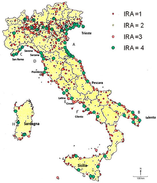
Figure 3.
Drowning Risk Index (Indice di Rischio di Annegamento, IRA) map based on observations from 2001 to 2008 []. Small dark dots indicate individual drowning events that occurred prior to the surveyed period. IRA 1: A single drowning incident within a six-year period in a given municipality, interpreted as a random event. IRA 2: Occasional incidents involving multiple victims, reflecting an elevated but episodic level of concern. IRA 3: Municipalities reporting at least one drowning per year, suggesting the presence of a systematic underlying cause. IRA 4: Municipalities experiencing more than two drownings almost every year, indicating a persistent and elevated risk. For the meaning of the letters A to H inside the figure, refer to the description below.
Excluding the regions of northern Italy that do not border the sea—where numerous drownings occur in rivers, lakes, and artificial canals—the sequence of green dots (IRA = 4), interspersed with red dots (IRA = 3), delineates eight coastal segments exhibiting high drowning risk. The phenomenon is particularly evident along the coastal sectors identified by letters on the map in Figure 3:
A—The central–northern Adriatic coast (from San Benedetto del Tronto to Trieste)
B—Sections of the southern Apulian coast
C—The Ligurian coast (between San Remo and Savona)
D—The Tuscan coast (between Carrara and Piombino)
E—The Lazio coast (between Fiumicino and Terracina)
F—The Campanian coast (from Castel Volturno to Agropoli)
G—The Sicilian coast, particularly the southeastern sector and the Palermo area
H—The Sardinian coast, especially the western sector and the areas surrounding Cagliari and Olbia
Although this classification remains relatively coarse—since it does not account for intra-municipal variations in site characteristics, timing, or the specific circumstances of individual incidents—it nonetheless highlights a critical pattern: six of the eight high-risk coastal segments coincide with areas known to be affected by natural rip currents []. The remaining two clusters (A and C), by contrast, correspond to highly artificialized shorelines, where coastal defence structures appear to generate artificial rip currents that contribute to systematic drowning hazards.
Building on this foundation, our research aimed to analyze the characteristics of drowning victims and the circumstances of the incidents, with particular attention to the presence or absence of coastal defence structures.
3. Material and Methods
3.1. Problems with Existing Data
One of the principal challenges in the study of drowning incidents—beyond the quantitative analysis of indicators such as the number of fatalities, their geographical distribution, and basic demographic variables (sex and age)—lies in the lack of detailed information regarding the circumstances of each event and its contextual conditions. This limitation significantly constrains the ability to accurately identify the underlying causal mechanisms of drowning.
Data collected by official agencies, such as the Italian National Institute of Statistics (ISTAT) or the World Health Organization (WHO), generally omit crucial contextual variables—for instance, the type of waterbody involved, the social group affected, the physical characteristics of the site, and the situational dynamics of the accident. While such datasets remain valuable for quantifying the overall magnitude of the phenomenon, their explanatory capacity is inherently limited, as they fail to elucidate the causal pathways through which drowning incidents occur.
Progress in this field therefore depends on detailed, case-by-case analyses of individual events. These analyses, guided by increasingly specific hypotheses, are essential to transform anecdotal or fragmentary information into systematic, evidence-based knowledge—datasets capable of testing and refining explanatory models. It is precisely this type of conclusive and context-rich data that enables a realistic representation of the phenomenon within the framework of sociological and environmental research.
In Italy, after a period of stagnation in research activity, a significant step forward occurred in 2012 with the introduction of press review analysis, whereby newspaper articles are systematically examined by searching for the term “annegamento” (“drowning”) and its derivatives across all national and regional daily newspapers.
Although this approach has often been met with scepticism—primarily due to the perception that press-derived data are “not official”—it has proven effective in several countries with data systems as limited as Italy’s, or even more restricted. Moreover, nations equipped with more advanced incident-reporting frameworks, such as Australia, New Zealand, Switzerland, the United States, and Great Britain [,,,,], routinely integrate information collected by lifesaving organizations and rescue personnel. For drowning research, such sources frequently constitute the most accurate and timely datasets available.
In parallel, citizen science has begun to make a growing contribution to formal scientific research, including in domains directly related to coastal monitoring and management []. This participatory approach offers valuable potential for enhancing data coverage, improving incident detection, and promoting public engagement in drowning prevention efforts.
3.2. Press Review Analysis and Additional Data Acquisition
For this study, data were collected through L’Eco della Stampa, a media monitoring and analysis service covering print, online, and broadcast content, extracting information from 1 May to 30 September of each year, a period corresponding to the official bathing season as defined by the Maritime Authorities’ Ordinance. Although it is not possible to determine the exact number of national and local newspapers analyzed, approximately 100 newspapers are currently published in Italy.
Each reported case was subsequently examined through site verification using Google Earth and interviews with eyewitnesses, primarily lifeguards. The collected data were then cross-checked against official records to produce representative annual figures that were free from duplication and reporting errors (Chart 1).

Chart 1.
Phases in which the research was developed.
The investigation was conceived as a sociological inquiry, encompassing all potentially reliable sources of information []. For each case, data were collected on the victim’s personal characteristics (sex, age, nationality, swimming ability, health status, cause of death, etc.), the type of waterbody involved (sea/coastal beaches, inland waters, or swimming pools), presence or absence of lifeguards, and the precise location along the shoreline where the incident occurred (data published in []).
The integration of these multiple information sources enabled the systematic reconstruction of each drowning incident, allowing for the identification of both the hazardous factors involved and the behavioural dynamics that triggered the event. As a result, the research generated datasets with substantial explanatory power, capable of informing targeted prevention strategies and broader public health policies, while also supporting a focused analysis of the interrelationships among the various factors contributing to drowning risk.
4. Results
During the six bathing seasons between 2016 and 2021, press reports documented 858 drowning incidents associated with recreational bathing activities. These incidents can be attributed to five primary causes or conditions: non-swimmers, rip currents, medical episodes, accidental falls into the water, and water sports (Figure 4).
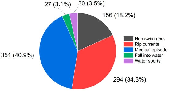
Figure 4.
Number and percentage of drownings by cause during bathing at marine beaches, 2016–2021.
This article presents the results of the first data analysis investigating the influence of coastal defence structures on drowning incidents, with findings summarized in Table 1 and Figure 5, organized by region. This regional breakdown reflects the administrative structure of Italy, where jurisdiction over recreational maritime areas—and thus responsibility for bathing safety—rests with the regional authorities.

Table 1.
Drownings along the Italian coastline and cases attributable to rip currents over a six-year period (2016–2021) *.
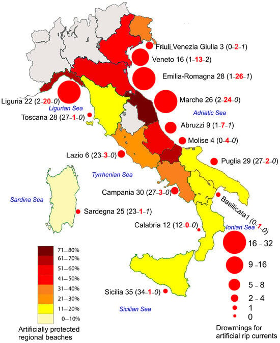
Figure 5.
Percentage of regional sandy coast protected by hard structures and number of total drownings induced by rip currents in the Italian regions in the period 2016–2021 (Normal: natural rip, Red: artificial rip, Italic: unidentified).
A specific legal framework delineates the division of institutional responsibilities between the state and the regions concerning the management of public maritime property. Consequently, the patterns observed in the data are not purely geographical; they also mirror regional policy choices, which over the past two decades have increasingly tended to prioritize sectoral economic interests over public safety in bathing areas.
In particular, swimmer safety has often been subordinated to the economic interests of a powerful lobbying group—the private beach concession holders (stabilimenti balneari, i.e., bathing establishments or beach clubs)—which have exerted substantial influence on coastal management policies in many Italian regions. Although analyzing this dynamic is of undeniable importance, it lies beyond the scope of the present article and would, in fact, merit a dedicated investigation.
From a geomorphological perspective, Italian coastlines also exhibit marked regional contrasts: the beaches of Liguria differ significantly from those of Tuscany, while Sicily and Sardinia, despite their internal variability, each display distinct morphological typologies.
The physical dimensions of the regions further contribute to disparities in drowning statistics. For example, Basilicata’s 37 km of Ionian sandy coastline, which recorded only one drowning over the six-year period, cannot be meaningfully compared with Sicily’s 1623 km of predominantly rocky shoreline. However, it is comparable to the 37 km of sandy coastline in the Ravenna area (Emilia-Romagna), extending from Casalborsetti to Lido di Classe, where up to 12 drowning fatalities have been recorded in a single summer season.
The case of Emilia-Romagna’s 130 km coastline is particularly noteworthy. This shoreline is entirely accessible for bathing and densely developed with private beach concessions, forming an almost continuous sequence of stabilized and artificialized beaches. Such conditions are cause for serious concern, as the region consistently ranks among the highest nationwide across nearly all drowning indicators, particularly those associated with rip currents.
5. Drowning Associated with Shore Protection Structures
Certain coastal defence structures generate water circulation patterns that can endanger both swimmers and non-swimmers, potentially leading to drowning. Moreover, even under calm sea conditions, seabed morphologies sculpted by storm-driven currents may persist over the long term, continuing to pose hazards for non-swimmers.
The coastal defence structures described above generate rip currents through two mechanisms: (1) hydraulic pressure exerted against the groins, which drives water offshore, and (2) the outflow of water through gaps between pairs of breakwaters caused by wave piling-up behind them. Both processes, though generally less intense, also occur in association with submerged structures.
However, the mortality associated with these two types of rip currents differs. Rip currents generated by groins allow swimmer responses similar to those recommended for natural rip currents—namely, allowing oneself to be carried beyond the breaker line, swimming parallel to the shore, and then returning to land. In addition, lifeguard intervention from the shore is possible in these situations.
By contrast, in the case of rip currents induced by gaps between breakwaters, once a swimmer is carried seaward beyond the structure, returning to shore is not feasible, as the waves would force him against the rocks. In such circumstances, rescue operations must be carried out from the sea, which requires significantly more time.
Seabed morphology near these structures reveals grooves formed by intense processes during storms, and approximately 17 individuals (12% of the victims), all non-swimmers, drowned after falling into such depressions or channels.
Artificial rip currents were responsible for 108 of the 294 total drowning incidents recorded between 2016 and 2021. They account for the vast majority of cases in Molise, Abruzzo, Marche, Emilia-Romagna, Veneto, and Friuli-Venezia Giulia, with additional scattered cases in other regions and a notable contribution from the western side of Liguria coast, rich in shore protection structures. Altogether, these regions comprise approximately 705 km of sandy shoreline. This corresponds to an average of 18 deaths per bathing season attributable to artificial rip currents.
By contrast, Basilicata recorded a single case caused by a groin structure. In Figure 5, the regions where artificial rip currents dominate drowning statistics are highlighted in brown-red. These include both steep, rocky shorelines, such as the western Ligurian Riviera, and flat, engineered beaches of the northern Adriatic. Without coastal engineering interventions, these areas would not generate rip currents strong enough to produce such a high number of fatalities.
In the Upper and Middle Adriatic, artificial rip currents are typically moderate (with some exceptions, notably along the Ravenna coastline), but they can be easily activated under mild wave conditions—sea states that often do not deter swimmers, even when red flag warnings are displayed. This occurs in highly crowded areas where beachgoers, who are often among the least proficient swimmers in Europe, frequently enter the water regardless of safety alerts.
This combination of high population density, mild wave activity, and proximity to protective structures explains why otherwise flat and seemingly benign beaches in regions such as Romagna, Marche, and Veneto—particularly Cavallino-Treporti, Jesolo, Eraclea, Duna Verde, Caorle, Bibione, and Lignano Sabbiadoro—produce a disproportionately high share of drowning fatalities.
In contrast in Liguria, characterized by steep, high-coast beaches, rip current hazards are concentrated mainly along the Savona–Ventimiglia stretch, where beaches are highly artificialized with near-continuous protective structures. The mechanisms by which relatively low-hazard coastal segments become high-risk zones often involve artificial embayments capable of generating powerful rip currents.
5.1. Groins (Emerged and Submerged)
Groins are coastal defence structures oriented perpendicular or slightly oblique to the shoreline and constructed along coasts subject to significant longshore sediment transport. They intercept sediment transport, promoting beach accretion on the updrift side while inducing erosion on the downdrift side. Such erosion is often mitigated through the construction of additional groins, leading to a proliferation of structures commonly referred to as the domino effect [].
At present, groins represent the most widely employed form of coastal defence worldwide, with approximately 15,000 examples documented across more than 60 countries []. In Italy, they are present along almost the entire coastline, particularly along the Adriatic Sea, where some of the longest groin fields are located—for instance, 126 groins distributed over 12 km at the mouth of the Piave River (Veneto) and 206 groins extending over 20 km north of Margherita di Savoia (Puglia) [].
Numerous studies, both field-based [] and numerical [], have documented the formation of rip currents on the updrift side of groins (Figure 6), where sand accumulation and swash alignment of the beach face occur. Following storm events, erosional channels with abrupt depth variations may persist, posing serious hazards to non-swimmers (Figure 7). However, during storms characterized by opposing wave directions, rip currents can shift to the downdrift side []. They may also develop where oblique groins have been constructed to create crenulate-shaped bays, particularly when waves occasionally approach from directions other than the prevailing one [].
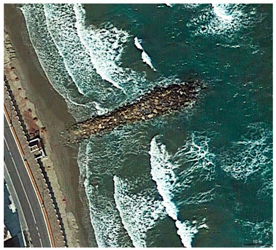
Figure 6.
Rip current along a groin at Laigueglia (Liguria; Google Earth 03 2007). The rip current is identifiable by the interruption in the line of breaking waves.
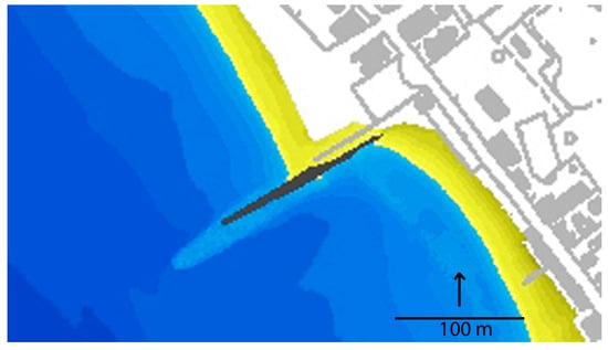
Figure 7.
Digital terrain model of the nearshore area around a groin at Marina di Cecina (Tuscany), showing the furrow produced by a rip current generated by southward wave incidence. The groin includes a submerged extension. Surveys conducted by Oikos on behalf of the Marina di Cecina Harbour Authority.
The efficiency of groins depends on the ratio between the spacing between pair of elements (Ls) and their individual length (Lg), with literature values typically ranging from Ls/Lg = 2 to 4 [], depending on the prevailing wave direction. The Shore Protection Manual [] (§5:38) advises: “As a guide to spacing groins, the following general rule is suggested: The spacing between groins should equal two to three times the groin length from the berm crest to the seaward end.”
If groins are spaced too closely, they may not function effectively, as sand cannot reach the beach before being intercepted by the next downdrift groin [].
On the other hand, groins spaced at these intervals induce faster rip currents than more tightly spaced groins [], creating a trade-off between coastal protection and swimmer safety.
Along Italian coasts, groin configurations vary widely, with Ls/Lg ratio ranging from 1 (e.g., Orno, Puglia; Figure 8, top, to over 6, such as south of Terracina (Lazio), where groins were recently extended with Y-shaped submerged segments (Figure 8, bottom).
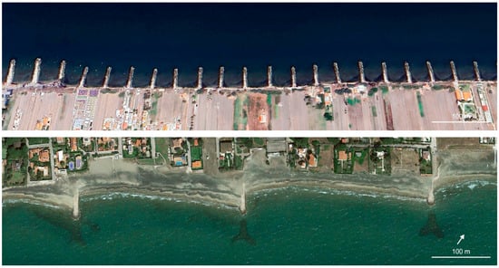
Figure 8.
Top: Groins placed in close proximity (Orno) and at wide spacing (between S. Felice Circeo and Terracina); Bottom: in the latter case, submerged Y-shaped extensions have been added. Google Earth images 19/2025 and 05/2016.
In Italy, coastal engineering practice includes a typology of groin that is relatively uncommon in other countries. These structures are anchored within the berm and extend into the swash zone, continuing into the nearshore area, so that, when effective, are not visible from the beach. Their purpose is to reduce sediment transport without fully interrupting it or diverting it toward the open sea. They are typically constructed using geobags, geocontainers, or prefabricated concrete elements shaped like an inverted T [].
Monitoring with multi beam surveys did not find grooves along their sides, but a hollow in front of their tips []; however, numerical simulations indicate a significant interference with wave motion, with energy concentration at the end of the structure (Figure 9) []. Their behaviour and impact of the beach morphology appear to be similar to that of permeable groins [], which, by contrast, are not used in Italy.
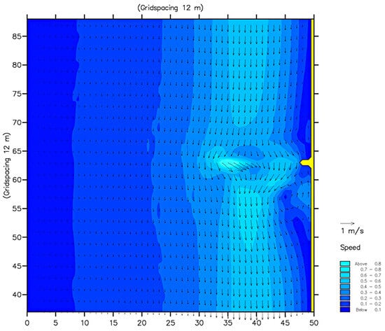
Figure 9.
Flow field of coastal circulation resulting from the interaction of incident wave motion with a submerged groin [].
During the observation period, no drownings attributable to this dynamic were recorded, but the number of such structures in Italy is still relatively low. However, since their presence is increasing, the issue deserves particular attention.
5.2. Detached Breakwaters (Emerged and Submerged)
The use of detached breakwaters for coastal protection is relatively recent compared to groins. The first such structures were built in the United States and Europe in the mid-1960s [], but their number has since increased rapidly, reaching approximately 12,000 worldwide []. Detached breakwaters are often arranged in series, with spacing typically ranging from 0.5 to 5 times their individual length []. These structures attenuate the incident wave energy reaching the shore, thereby creating a low-energy zone between the breakwater and the coastline where sediment deposition is promoted. Depending on the ratio between the breakwater length and its distance from the shoreline, this process can result in the formation of salients or tombolos [].
Sediment accumulation within the sheltered area originates both from adjacent unprotected sectors—transported by waves diffracted around the breakwater tips—and from materials conveyed through the gaps between structures, mobilized by turbulence generated by wave reflection at the breakwater base [].
To overcome some of the limitations of traditional detached breakwaters, submerged parallel structures with varying degrees of submergence (i.e., the vertical distance between the structure crest and the mean sea level) have recently been adopted. This configuration allows partial wave transmission while substantially reducing wave reflection, thereby enhancing water quality—an aspect of particular importance for tourist beaches. When the crest width is sufficiently large relative to the incident wavelength, significant energy dissipation can still occur even when the structure remains submerged [].
Behind the reef, water tends to accumulate due to overtopping or percolation through the porous structure, leading to an increase in mean water level (a phenomenon known as piling-up). This effect has been documented through numerical simulations [], field observations [], and laboratory experiments [,,]. The transmitted waves thus propagate over an elevated water surface, potentially advancing further inland. In submerged reefs with narrow crests, however, the benefits of energy dissipation may be counterbalanced by the adverse consequences of piling-up.
In Italy, emerged detached breakwaters have been extensively constructed along the Adriatic coast under the direction of the Ufficio del Genio Civile—Opere Marittime, the former authority responsible for coastal protection before these competences were transferred to the regional administrations in 1998. From the end of World War II until the 1990s, breakwaters typically followed a standard design consisting of 80 m-long structures separated by 40 m gaps. Many of these installations, as well as comparable ones built elsewhere, have since been modified and, more recently, often lowered below the mean sea level [,].
During the 1990s, numerous submerged reefs were constructed in Italy to create perched beaches, with the goal of prolonging the effectiveness of beach nourishment interventions. This approach has been implemented, for instance, along the coast of Lazio [,].
With respect to drowning hazards, submerged or partially emerged breakwater configurations represent some of the most dangerous conditions. The piling-up phenomenon generates intense return currents, as demonstrated by numerical modelling (Figure 10) [], by photographs captured during storm events (Figure 11), and by evidence of seabed scouring observed in multibeam surveys, such as at Follonica (Figure 12). At this site, the beach is protected by a continuous submerged reef with a crest positioned 0.3 m below mean sea level (b.m.s.l.), interspersed with gaps having a submergence of 1.0 m to permit boat passage. Multibeam surveys have revealed pronounced erosion grooves on the landward side of the reef, formed by return currents driven by the piling-up effect. These currents converge at the gaps and subsequently flow seaward, where they excavate deep holes just beyond the openings.
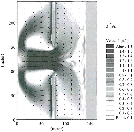
Figure 10.
Current field simulated with MIKE21 for low crest breakwater with overtopping [].
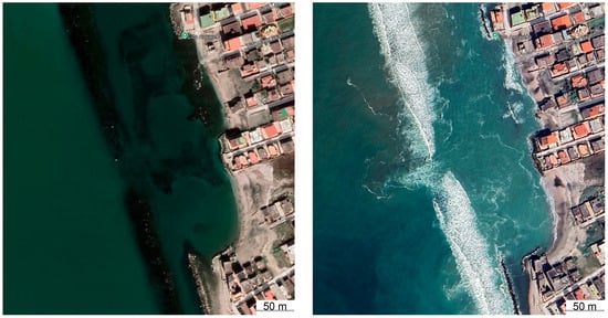
Figure 11.
Castel Volturno (Calabria): Rip current (see interruption of breakers line) generated by piling-up behind a submerged detached breakwater (Google Earth 2/2022 and 3/2024).
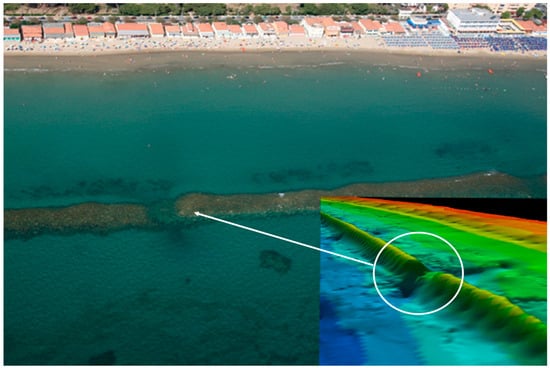
Figure 12.
Follonica (Tuscany): Erosion furrow on the seabed produced by the current directed towards the threshold of the submerged reef and hole dug at the exit. Three-Dimensional model produced by Geocoste s.n.c. for the University of Florence.
When swimmers are transported seaward beyond the breakwaters, their ability to return to shore by lateral movement—typically possible in natural rip current systems—is hindered by the presence of the rock structures.
Data collected by Frihy et al. [] from local hospitals indicate an average of 35 drowning incidents per year at Baltim and 67 at Ras El Bar (Egypt), attributed to rip currents generated within detached breakwater systems.
A visually documented case at Marina di Massa (Italy) involved an adult standing landward of an emerged parallel reef, in waist-deep water during a moderate storm. Believing he was protected by the reef, as waves were breaking seaward of the structure, he was first carried laterally along the coast toward a gap and subsequently swept offshore, from where he was unable to return to shore (Figure 13).
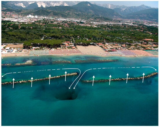
Figure 13.
Marina di Massa (Tuscany): 3D model (with vertical exaggeration) of the nearshore zone showing detached breakwaters and pronounced scouring at the gap exits. The 3D model was generated by Geocoste s.n.c. for the University of Florence.
At Marina di Pisa (Tuscany), two young men swimming in a 2 m-deep area between a revetment and a detached breakwater were dragged offshore and drowned (Figure 14). In this case, the breakwater crest is located 2.5 m above mean sea level (a.m.s.l.), while the gap floor lies approximately 1.0 m below mean sea level.
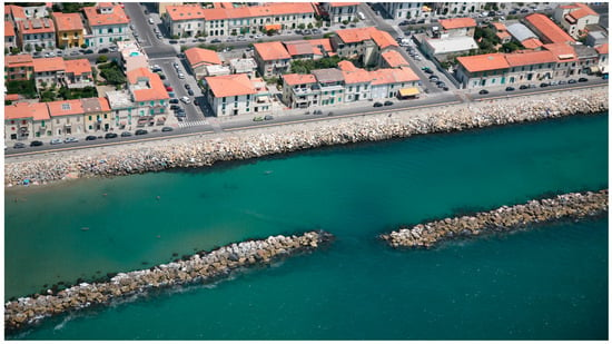
Figure 14.
Marina di Pisa, the stretch of coast where two young men were swimming in the waters protected by the breakwater and were swept out through the gap and drowned (image courtesy Provincia di Livorno).
Sudden drops on the lee side of both emerged and submerged detached breakwaters also pose a significant hazard to non-swimmers. These drops are created by waves plunging directly onto the structure or immediately after passing over it []. The perched beach typically exhibits a flat profile, which encourages people to move farther from the shore, where they may unexpectedly encounter a step leading rapidly to non-wading depths (Figure 15).
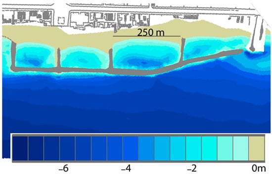
Figure 15.
Marina di Massa (Tuscany): erosional channels on the leeside of a low crest (0 m a.s.l.) breakwater. Bathymetric survey carried out by GeoCoste s.n.c. on behalf of the University of Florence.
5.3. Multiple Coastal Structures
A common and increasingly widespread coastal defence configuration in Italy consists of emerged or submerged parallel breakwaters connected to the shoreline by groins—typically featuring a landward section emerging above sea level and an offshore connection that remains submerged (Figure 16).
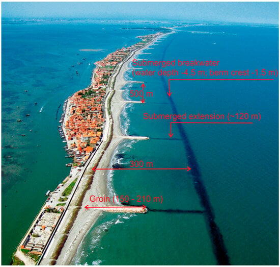
Figure 16.
Pellestrina (Venice): a continuous submerged breakwater, connected to the shoreline by groins that are partly emerged and partly submerged. The structure was constructed to contain an artificial nourishment of approximately 4,000,000 m3. (Image courtesy Consorzio Venezia Nuova).
However, highly imaginative combinations of coastal defence structures can also be found (Figure 17). Such arrangements allow for highly variable layouts depending on the geometry of the individual components, thereby generating a wide range of potential risk scenarios.
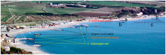
Figure 17.
Fiumaretta (Liguria): On the left sector of the coastline, groins were added to an originally island-based defence system to connect the artificial islands to the shore. Subsequently, submerged breakwaters were constructed in some sections to link the islands to one another, and a submerged groin was later added (the sequence of constructions is indicated by the numbers from 1 to 5). On the right sector, following the construction of an initial short groin, two additional longer groins were built, and the coastal cell was eventually almost completely enclosed by an emerged shore-parallel breakwater (the sequence of constructions is indicated by the letters from a to c).
In some cases, this configuration originates from an intentional design, as in Pellestrina (Figure 16). In many others, however, it results from successive additions and modifications to projects implemented over several years. A notable example is Marina di Massa (Tuscany), where closely spaced groins (Ls/Lg = 1) were initially constructed, yielding unsatisfactory results. A low-crested, shore-parallel breakwater was subsequently added, connecting the groin tips, but this also produced limited effectiveness. The breakwater was later gradually raised to sea level, leading to a relative stabilization of the shoreline; however, the beach profile in front of the reef lowered due to wave reflection, which in turn contributed to further beach destabilization.
At Fiumaretta (Liguria), the original circular artificial islands were first connected to the shore by groins, after which a submerged breakwater was constructed to link them. Subsequent additions of submerged reefs and groins further increased the complexity of the system (Figure 17).
Most of these configurations generate the so-called “pool effect”, in which wave overtopping and infiltration processes lead to an increase in the mean water level (piling-up) within the enclosed basin, particularly during rough sea conditions.
Orthogonal structures, such as groins, inhibit lateral water exchange, forcing the excess water to discharge through narrow gaps. This constrained outflow produces extremely strong seaward currents, often comparable in intensity to river torrents. A swimmer caught in one of these currents under storm conditions has very limited chances of survival, and mortality rates in such environments are disproportionately high.
In some cases, shore-parallel barriers constructed too close to the shoreline have induced the formation of tombolos at their extremities, reproducing the same hazardous hydrodynamic conditions—although generally less intense—observed in larger artificial basins.
These artificial basins and nearshore-connected barriers account for more than 70% of all drownings associated with artificial rip currents []. The elevated risk can be interpreted through the concepts of the Illusion of Safety and the Risk Paradox. Their danger stems from two interrelated factors:
- -
- Deceptive sense of security: the enclosed, pool-like appearance of these basins conveys an impression of safety and protection from open-sea hazards—conditions that lead swimmers to underestimate danger and behave overconfidently;
- -
- Low perceived risk: from a risk psychology perspective, hazards that appear benign are inherently more dangerous because they catch individuals unprepared. The perceived safety itself increases exposure to risk.
6. Conclusions
The analysis revealed that in regions with few coastal defence structures but strong exposure to wave action, drownings associated with rip currents were primarily linked to naturally occurring currents. Conversely, in regions characterized by a high density of coastal defences, rip current–related drownings were frequent even under conditions of moderate wave exposure. Furthermore, it was observed that certain coastal defence structures—particularly detached breakwaters—can create a deceptive perception of safety among bathers, leading them to believe they are in sheltered waters even during storms, while, in fact, the most hazardous rip currents often develop immediately landward of these structures.
Case analyses also demonstrated that rip current mortality is higher in the presence of detached breakwaters with gaps than in areas protected by groins. In the latter case, both the spontaneous return of a swimmer to the beach after being carried beyond the surf zone and the intervention of a shore-based lifeguard are generally possible. In contrast, for detached breakwaters, the physical obstruction of the structures prevents return to shore, and rescue must be carried out from the seaward side, often resulting in significantly longer recovery times.
To align with WHO recommendations concerning the prevention of marine drownings, it is essential that the processes associated with coastal protection works be fully understood by both coastal safety professionals and beach users. Specific training modules on these topics should be incorporated into lifeguard certification programmes, and coastal engineering curricula should explicitly address the safety implications of coastal defence designs. Moreover, coastal defence projects should integrate risk as a design parameter and include appropriate mitigation measures. These aspects are currently under consideration by national legislative authorities.
Author Contributions
Conceptualization, E.P. and D.G.P., data collection and analysis D.G.P., shore protection structure analysis E.P., epidemiological aspects D.G.P., writing—review and editing, E.P. and D.G.P. All authors have read and agreed to the published version of the manuscript.
Funding
This research received no external funding.
Data Availability Statement
The original contributions presented in this study are included in the article. Further inquiries can be directed to the corresponding author.
Acknowledgments
This research was carried out within the framework of the activities of the Observatory for the development of a national drowning prevention strategy of the Ministry of Health.
Conflicts of Interest
The authors declare no conflict of interest.
References
- SIB Sindacato Italiano Balneari. Stati Generali del Turismo Balneare, Roma. FIPE–Confcommercio. 2025. Available online: https://www.sindacatobalneari.it/comunicato-stampa/stati-generali-del-turismo-balneare-roma-5-marzo-2025-1 (accessed on 29 September 2025).
- Economia del Mare. 2024. Available online: https://www.economiadelmare.org/il-turismo-balneare-vale-il-20-del-turismo-nazionale-federbalneari-un-convegno-per-ragionare-sulla-crescita-della-blue-economy/?utm_source=chatgpt.com (accessed on 18 September 2025).
- ISPRA, 2024. Costa. Available online: https://indicatoriambientali.isprambiente.it/it/coste (accessed on 7 April 2025).
- Ministero Delle Infrastrutture E Dei Trasporti. Online I Dati Aperti Delle Concessioni Demaniali Marittime. Available online: https://www.mit.gov.it/node/7965?utm_source=chatgpt.com (accessed on 12 September 2025).
- Pranzini, E.; Williams, A.T. (Eds.) Coastal Erosion and Protection in Europe; Routledge: London, UK; New York, NY, USA, 2013; pp. 294–323. 476p. [Google Scholar]
- Berriolo, G.; Sirito, G. Spiagge e Porti Turistici; Hoepli: Milano, Italy, 1972; 430p. [Google Scholar]
- Utizi, K.; Corbau, C.; Rodella, I.; Nannini, S.; Simeoni, U. A Mixed Solution for a Highly Protected Coast (Punta Marina, Northern Adriatic Sea, Italy). Mar. Geol. 2016, 381, 114–127. [Google Scholar] [CrossRef]
- Cleo, D.; Santi, R. Riccione’s Study Case: Experimentation of Innovative Artificial Reef for Coastal Defense and Increase. Mar. Biodiv. 2024, 683–694. [Google Scholar] [CrossRef]
- Bowman, D.; Ferri, S.; Pranzini, E. Efficacy of Beach Dewatering—Alassio (Italy). Coast. Eng. 2007, 54, 791–800. [Google Scholar] [CrossRef]
- Pranzini, E. Shore Protection in Italy: From Hard to Soft Engineering … and back. Ocean Coast. Manag. 2018, 156, 43–57. [Google Scholar] [CrossRef]
- Pranzini, E. Significance of Grain Size in Beach Nourishment. Discussion of: Griggs, G. Beach Nourishment: A Critical Look. J. Coast. Res. 2024, 40, 962–971. [Google Scholar]
- Nordstrom, K.F. Living with Shore Protection Structures: A Review. Estuar. Coast. Shelf Sci. 2014, 150, 11–23. [Google Scholar] [CrossRef]
- Rangel-Buitrago, N.; Williams, A.T.; Anfuso, G. Hard Protection Structures as a Principal Coastal Erosion Management Strategy along the Caribbean Coast of Colombia. A chronicle of Pitfalls. Ocean Coast. Manag. 2018, 156, 58–75. [Google Scholar] [CrossRef]
- Sanitwong-Na-Ayutthaya, S.; Saengsupavanich, C.; Helmy Ariffin, E.; Sandaruwan Ratnayake, A.; Shin Yun, L. Environmental Impacts of Shore Revetment. Heliyon 2023, 9, e19646. [Google Scholar] [CrossRef] [PubMed]
- Cantasano, N.; Boccalaro, F.; Ietto, F. Assessing of Detached Breakwaters and Beach Nourishment Environmental Impacts in Italy: A Review. Environ. Monit Assess. 2022, 195, 127. [Google Scholar] [CrossRef]
- Saengsupavanich, C.; Ariffin, E.H.; Yun, L.S.; Pereira, D.A. Environmental Impact of Submerged and Emerged Breakwaters. Heliyon 2022, 8, e12626. [Google Scholar] [CrossRef]
- Ishikawa, I.; Komine, T.; Aoki, S.I.; Okabe, T. Characteristics of Rip Current Drowning on the Shores of Japan. J. Coast. Res. 2014, 72, 44–49. [Google Scholar] [CrossRef]
- Lee, M.T.; Wu, C.H.; Ho, Y.F. Coastal Drowning Incidents and Nearshore Environmental Conditions in Taiwan. Ocean Coast. Manag. 2025, 262, 107545. [Google Scholar] [CrossRef]
- Koon, W.; Peden, A.; Lawes, J.C.; Brander, R.W. Coastal Drowning: A Scoping Review of Burden, Risk Factors, and Prevention Strategies. PLoS ONE 2021, 16, e0246034. [Google Scholar] [CrossRef]
- WHO (World Health Organization). Global Status Report on Drowning Prevention; WHO Press: Geneva, Switzerland, 2024; 243p. [Google Scholar]
- Ferrara, F.; Funari, E.; Pezzini, D.G. Osservatorio per lo Sviluppo di una Strategia Nazionale di Prevenzione Degli Annegamenti e Incidenti Nelle Acque di Balneazione: Primo Rapporto; Ministry of Health: Rome, Italy, 2023; ISTISAN 2023/15; 144p. [Google Scholar]
- Giustini, M.; Trinca, S. Incidenti di Annegamento in Italia, Dati di Mortalità; Report ISTISAN 12/23; Ministry of Health: Rome, Italy, 2012; 42p. [Google Scholar]
- Pezzini, D.G. Incidenti di annegamento in Italia nel contesto delle attività balneari. In Rapporti ISTISAN 23/15; Ministry of Health: Rome, Italy, 2023; pp. 2–74. [Google Scholar]
- Royal Lifesaving. Australia Lifeguarding; Royal Lifesaving Australia: Castle Hill, Australia, 2016; 153p. [Google Scholar]
- Surf Lifesaving Society. Surf Lifeguard New Zealand, Training Manual; Surf Lifesaving Society: Tauranga, New Zealand, 2019; 10p. [Google Scholar]
- Società Svizzera di Salvataggio. Società Svizzera Di Salvataggio Rapporto Di Sicurezza Acquatica; SLRG SSS: Lugano, Switzerland, 2024; pp. 2–32. [Google Scholar]
- Brewster, B.C. Open Water Lifesaving. In Pearson Education; U. S. Lifesaving Association: Los Angeles, CA, USA, 2017; pp. 101–113. [Google Scholar]
- RoSPA. Royal Society for the Prevention of Accidents, Great Britain. In Safety on British Beaches; Prevention of Accidents: Birmingham, UK, 1993; 40p. [Google Scholar]
- Hart, J.D.; Blenkinsopp, C.E. Using Citizen Science to Collect Coastal Monitoring Data. J. Coast. Res. 2020, 95, 824–828. [Google Scholar] [CrossRef]
- Pezzini, D.G. Drowning Causes on Italian Beaches: Epidemiological data. In Proceedings of the WCDP, World Conference on the Prevention of Drowning, Durban, South Africa, 8–10 October 2019. [Google Scholar]
- Cooper, J.A.G.; Anfuso, G.; Del Río, L. Bad Beach Management: European Perspectives; Geological Society of America: Boulder, CO, USA, 2009; p. 460. [Google Scholar]
- Angnuureng, D.; Charuka, B.; Almar, R.; Dada, O.; Asumadu, R.; Agboli, N.; Ofosu, G. Challenges and Lessons Learned from Global Coastal Erosion Protection Strategies. Science 2025, 28, 112055. [Google Scholar] [CrossRef]
- Komar, P.D. Beach Processes and Sedimentation, 2nd ed.; Prentice Hall: Saddle River, NJ, USA, 1998. [Google Scholar]
- Pattiaratchi, C.; Olsson, D.; Hetzel, Y.; Lowe, R. Wave-driven Circulation Patterns in the Lee of Groynes. Cont. Shelf Res. 2009, 29, 1961–1974. [Google Scholar] [CrossRef]
- van Rijn, L.C. Coastal Erosion and Control. Ocean Coast. Manag. 2011, 54, 867–887. [Google Scholar] [CrossRef]
- French, P.W. Coastal Defences. Processes, Problems and Solutions; Routledge: London, UK, 2001; 366p. [Google Scholar]
- Silvester, R. Headland Defense of Coasts. Conf. Coast. Eng. 1976, 2, 1394–1406. [Google Scholar] [CrossRef]
- U.S. Army Coastal Research Centre. Shore Protection Manual, Fort Belvoir; Scientific Research: Richmond, VA, USA, 1975; Volume 2. [Google Scholar]
- Ergin, A. Coastal Engineering; Metu Press: Ankara, Turkey, 2009; 365p. [Google Scholar]
- Scott, T.; Austin, M.; Masselink, G.; Russell, P. Dynamics of Rip Currents Associated with Groynes—Field Measurements, Modelling and Implications for Beach Safety. Coast. Eng. 2016, 107, 53–69. [Google Scholar] [CrossRef]
- Aminti, P.; Cammelli, C.; Cappietti, L.; Jackson, N.L.; Nordstrom, K.F. e Pranzini E.—Evaluation of Beach Response to Submerged Groin Construction at Marina di Ronchi, Italy, Using Field Data and a Numerical Simulation Model. J. Coast. Res. 2004, 33, 99–120. [Google Scholar]
- Cappietti, L. La simulazione numerica della circolazione costiera: Uno strumento a supporto anche delle attività di salvamento. Studi. Costieri. 2019, 28, 3–13. [Google Scholar]
- Dette, H.H.; Raudkivi, A.J.; Oumeraci, H. Permeable Pile Groin Fields. In Functioning and Design of Coastal Groins: The Interaction of Groins and the Beach-Process and Planning. J. Coast. Res. 2004, 33, 145–159. [Google Scholar]
- Silvester, R.; Hsu, J.R.C. Coastal Stabilization. Innovative Concepts; PRT Prentice Hall: Englewood Cliffs, NJ, USA, 1993; p. 578. [Google Scholar]
- Hanson, H.; Kraus, N.C. Shoreline Response to a Single Transmissive Detached Breakwater. In Proceedings of the 22nd International Conference on Coastal Engineering, Delft, The Netherlands, 2–6 July 1990; pp. 2034–2046. [Google Scholar]
- Mizutani, N.; Rufin, T.M., Jr.; Iwata, K. Stability of Armor Stones of a Submerged Wide-Crown Breakwater. Coast. Eng. 1994, 1995, 1439–1453. [Google Scholar]
- Calabrese, M.; Vicinanza, D.; Buccino, M. 2D Wave Setup Behind Submerged Breakwaters. Ocean Eng. 2008, 35, 1015–1028. [Google Scholar] [CrossRef]
- Cappietti, L.; Sherman, D.J.; Ellis, J.T. Wave Transmission and Water Setup Behind an Emergent Rubble-Mound Breakwater. J. Coast. Res. 2013, 29, 694–705. [Google Scholar]
- Dronen, N.; Karunarathna, A.; Fredsoe, J.; Misumer, B.; Deigard, R. An Experimental Study of Rip Channel Flow. Coast. Eng. 2002, 45, 223–238. [Google Scholar] [CrossRef]
- Aminti, P.L.; Zanuttigh, B.; Lorenzoni, C.; Martinelli, L.; Clementi, E. Esperimenti di laboratorio ed osservazioni di campo sulle modifiche indotte al fondo da opere tracimabili. Studi. Costieri. 2005, 9, 159–190. [Google Scholar]
- Ruol, P.; Martinelli, L.; Zanuttigh, B.; Cappietti, L.; Vicinanza, D.; Faedo, A. Sui fenomeni di tracimazione, filtrazione e pilig-up per opere di difesa tracimabili. Studi. Costieri. 2005, 9, 51–74. [Google Scholar]
- Mancinelli, A.; Aminti, P.L.; Archetti, R.; Atzeni, A.; Canu, V.; Cappietti, L.; Lorenzoni, C.; Zanuttigh, B. Opere di difesa realizzate con strutture sommerse ed a cresta bassa ad Alghero (SS), PerdÂ’e Sali (CA), Marina di Massa (MS), Marina di Pisa (PI), Porto Recanati (MC), Marina di Montemarciano (AN), Lido di Dante (RA) e Pellestrina (VE). Studi. Costieri. 2005, 9, 7–50. [Google Scholar]
- Pranzini, E.; Jackson, N.L.; Lami, G.; Nordstrom, K.F.; Rossi, L. Reshaping Beach Morphology by Modifying Offshore Breakwaters. Ocean Coast. Manag. 2018, 154, 168–177. [Google Scholar] [CrossRef]
- Caputo, C.; Chiocci, F.L.; Ferrante, A.; La Monica, G.B.; Landini, B.; Pugliese, F. La ricostruzione dei litorali in erosione mediante ripascimento artificiale e il problema del reperimento degli inerti. In La Difesa dei Litorali in Italia; Aminti, P.L., Pranzini, E., Eds.; Edizioni delle Autonomie: Rome, Italy, 1993; pp. 121–151. [Google Scholar]
- Silva, P.; Di Girolamo, P. Interventi di ripascimento artificiale sul litorale di Pellestrina (VE). In La Difesa dei Litorali in Italia; Aminti, P.L., Pranzini, E., Eds.; Edizioni delle Autonomie: Rome, Italy, 1993; pp. 269–282. [Google Scholar]
- Balzano, A.; Cappietti, L.; Soldini, L.; Zanuttigh, B. Modellazione numerica della circolazione attorno ad opere tracimabili. Studi. Costieri. 2005, 9, 119–157. [Google Scholar]
- Frihy, O.E.; El Banna, M.M.; El Kolfat, A.I. Environmental Impacts of Baltim and Ras El Bar Shore-parallel Breakwater Systems on the Nile Delta Littoral Zone, Egypt. Environ. Geol. 2004, 45, 381–390. [Google Scholar] [CrossRef]
- Yıldırım, M.E.; Yaman, M.; Baykal, C. Scour at the rear side of rubble mound revetments due to random wave overtopping: Laboratory experiments. Ocean Eng. 2024, 309, 118401. [Google Scholar] [CrossRef]
- Pezzini, D.G. Costal Hard Defences and Artificial Rip Currents: The Italian Case. In Proceedings of the WCDP, World Conference on the Prevention of Drowning Annals, Vancouver, BC, Canada, 17–19 October 2017. [Google Scholar]
Disclaimer/Publisher’s Note: The statements, opinions and data contained in all publications are solely those of the individual author(s) and contributor(s) and not of MDPI and/or the editor(s). MDPI and/or the editor(s) disclaim responsibility for any injury to people or property resulting from any ideas, methods, instructions or products referred to in the content. |
© 2025 by the authors. Licensee MDPI, Basel, Switzerland. This article is an open access article distributed under the terms and conditions of the Creative Commons Attribution (CC BY) license (https://creativecommons.org/licenses/by/4.0/).