You are currently viewing a new version of our website. To view the old version click .
Environments
  • Article
  • Open Access

11 November 2025

Long-Term Monitoring of Arundo donax L. Range in Albufera Wetland (Spain): Management Challenges and Policy Implications

,
,
and
1
Cavanilles Institute of Biodiversity and Evolutionary Biology, Universitat de València, 46980 Valencia, Spain
2
Aquaculture and Biodiversity Research Group, Institute of Animal Science and Technology, Universitat Politècnica de València, Camino de Vera 14, 46022 Valencia, Spain
*
Author to whom correspondence should be addressed.
This article belongs to the Special Issue Urban Water Ecology: Aquatic Biodiversity, Habitat Restoration and Conservation

Abstract

Arundo donax L. (common reed), a highly invasive species in Mediterranean wetlands such as the Albufera Natural Park, poses significant ecological and management challenges. Using Landsat-5 and Sentinel-2 NDVI data, this study quantified changes in its coverage between 1996 and 2024. The results reveal a significant expansion, showing a decreasing trend (91.4 ha in 1996 to 62.5 ha in 2011; −31.6%) followed by a clear rebound (83.5 ha in 2024; +33.6%), especially in the southern shrublands of the lagoon. A Mann–Kendall analysis confirmed a significant decreasing trend during 1996–2011 and an increasing trend during 2011–2024 (p < 0.05). The results indicate that previous control efforts reduced A. donax cover but that the species has recolonised after 2011, likely due to discontinuous management. These dynamics emphasise that long-term monitoring is required. Management strategies must focus on targeting the rhizome and implementing long-term monitoring programmes spanning three to five years. The utilisation of remote sensing methodologies proved effective in the monitoring of coverage, thereby facilitating the development of remediation strategies. It is imperative that actions accord primacy to critical areas such as the south and canals, complemented by native restoration and enhanced inter-administrative coordination, with the communication of benefits such as flood risk reduction. A balanced approach is required that considers ecological objectives, risks, and socio-political aspects.

1. Introduction

The rapid loss of biodiversity observed worldwide is driven by factors such as habitat degradation, climate change [], and the spread of invasive alien species []. The Mediterranean basin, recognised as one of the planet’s major biodiversity hotspots, hosts over 25,000 plant species, with nearly half of them being endemic [,].
Within the broader context of the Spanish Mediterranean region, the Albufera Natural Park (hereinafter, N.P.) is a notable location in terms of biodiversity, exhibiting a diverse array of habitats that support a rich variety of fauna and flora species []. In recognition of its ecological significance, it was designated a Special Protection Area (SPA) in 1994 and subsequently incorporated into the Natura 2000 Network []. The shallow depth of the Albufera lagoon has facilitated the proliferation of submerged and emergent aquatic vegetation due to its change to freshwater in about 1850, which has covered most of the lagoon. However, from the 1940s onwards, there was a marked deterioration in water quality, a process that accelerated in the 1960s, resulting in the near-total disappearance of the vegetation by the 1970s, except for the reeds that were to be found on the banks. This decline can be attributed primarily to urban and industrial expansion within the basin []. Another of the main factors endangering the native vegetation of the Albufera Natural Park is the presence of invasive alien species. These species are distinguished by their high competitive capacity for space and resources, and also their potential to modify the environment, as is the case of Arundo donax L., 1753 (hereinafter A. donax) [].
A. donax has become predominant in the Albufera National Park in the last 30 years. This geophyte, which is characterised by its rhizomatous growth pattern, can reach altitudes of up to 6 m and possesses robust stems with the capacity to persist for multiple years. It forms dense clumps due to short, solid, and thick rhizomes. The stems possess internodes measuring approximately 10 cm, exhibiting glabrous nodes that facilitate the development of leaves, buds, adventitious roots, and new shoots through processes such as tillering or fragmentation. The inflorescence is a large panicle composed of approximately one thousand spikelets. This description focuses on the invasive clonal lineage of A. donax present in the Mediterranean basin and other warm regions of the world, including the United States, South America, southern Africa, Mexico, the Pacific islands, and the Caribbean [,].
Among these, A. donax (giant reed) has become one of the most problematic invasive plants in Mediterranean wetlands. Its rapid clonal growth and dense rhizomatous structure allow it to outcompete native vegetation, alter hydrological regimes, and modify soil properties [,]. Ecologically, A. donax invasions reduce plant diversity, increase evapotranspiration and fire risk, and disrupt carbon cycling and sediment dynamics, enhancing soil erosion and organic matter loss [,,]. Its failure to develop adequate structural cover, thereby allowing greater light entry, results in alterations to riparian microclimates, leading to an increase in water temperature []. Additionally, it contributes to an increase in pH in shallow river areas by favouring the photosynthetic activity of algae [,]. A. donax has been observed to displace native species due to its high productivity, which is based on its physiological characteristics and capacity for clonal growth, both vertically (via stems) and horizontally (via rhizomes) [].
Furthermore, the presence of vegetation in channels has been demonstrated to have a dual influence on both the hydrological flow and the surrounding environmental conditions. Aquatic plants growing in rivers and streams have been directly associated with several effects that play a dual role in flooding. On the one hand, an association has been observed between the presence of aquatic vegetation and a decrease in flow velocity, which has been interpreted as a reduction in flood risk. On the other hand, it has also been associated with channel blockage, which has been linked to a higher flood risk [,].
In particular, dense stands of A. donax in the Santa Ana River in southern California have been observed to channel floodwaters more intensively than native willow stands [,,]. However, the role of reeds in the flash flood in Valencia county in the context of the isolated high-level depression that occurred on 29 October 2024 was highly controversial. It was hypothesised that the presence of these reeds might have reduced the drainage capacity of rivers and canals by clogging and narrowing their channels when accumulating on the column bridges, a phenomenon that has been observed to result in sediment accumulation [].
While the European Union Water Framework Directive (WFD) does not explicitly address alien species, it is evident that invasive alien species are recognised as a factor negatively affecting water bodies covered by the WFD [,,]. The inclusion of invasive species in the ecological quality index could be conceptualised as a stressor, potentially leading to a lower classification of a water body [].
The mapping and monitoring of the distribution, status, and abundance of plant species represent fundamental technical activities in the context of sustainable wetland management. These actions encompass a variety of functions, such as conducting natural resource inventories and assessments, habitat description, and water quality analysis []. Furthermore, the implementation of conservation and restoration programmes for the vegetation environment is contingent on the availability of contemporary data on the extent and condition of vegetation [].
Remote sensing has become an essential tool for detecting and monitoring invasive plant species at landscape scales. Several studies have demonstrated the utility of Landsat and Sentinel imagery for mapping and quantifying invasive macrophytes in wetlands [,,]. The Normalised Difference Vegetation Index (NDVI) is among the most widely applied spectral indices for vegetation monitoring; however, its accuracy can be affected by soil background and atmospheric conditions []. To address these limitations, other indices such as the Enhanced Vegetation Index (EVI) and the Normalised Difference Water Index (NDWI) have been used to improve the discrimination of vegetation and water surfaces in mixed wetland environments [].
In this context, the objective of the present study is to monitor the evolution of A. donax in the shrublands of the Albufera of Valencia during the last three decades using previous aerial pictures and remote sensing tools, and to explore possible measures for the management of these plant masses. The novelty of this work lies in its status as the first to undertake such extensive long-term monitoring of this species within the Albufera of Valencia environment, and moreover, it is the first to employ remote sensing techniques by integrating Sentinel-2 with Landsat-8. Moreover, the significance of this study lies in its capacity to identify trends that can be utilised to formulate more efficacious management strategies.

2. Materials and Methods

2.1. Study Site

The Albufera of Valencia is a Mediterranean wetland area renowned for its wide variety of habitats and its high level of biodiversity [,]. The study area focuses on six stands of A. donax (giant reeds) located on the edge of the Albufera of Valencia lagoon. As demonstrated in Figure 1, the stands in the present study are named locally as La Barra, Fangaret, Manseguerota, San Roc, Pujol Vell, and En Torre. The plant represents a threat to the native vegetation of the natural park due to its high competitive capacity for space and resources, and its potential to modify the environment.
Figure 1. Location of the six study sites within the Albufera of Valencia lagoon. Green: La Barra; orange: Fangaret; pink: Manseguerota; violet: San Roc; red: Pujol Vell; blue: En Torre. The image was captured on 29 February 2024 by Sentinel-2.

2.2. Field Work

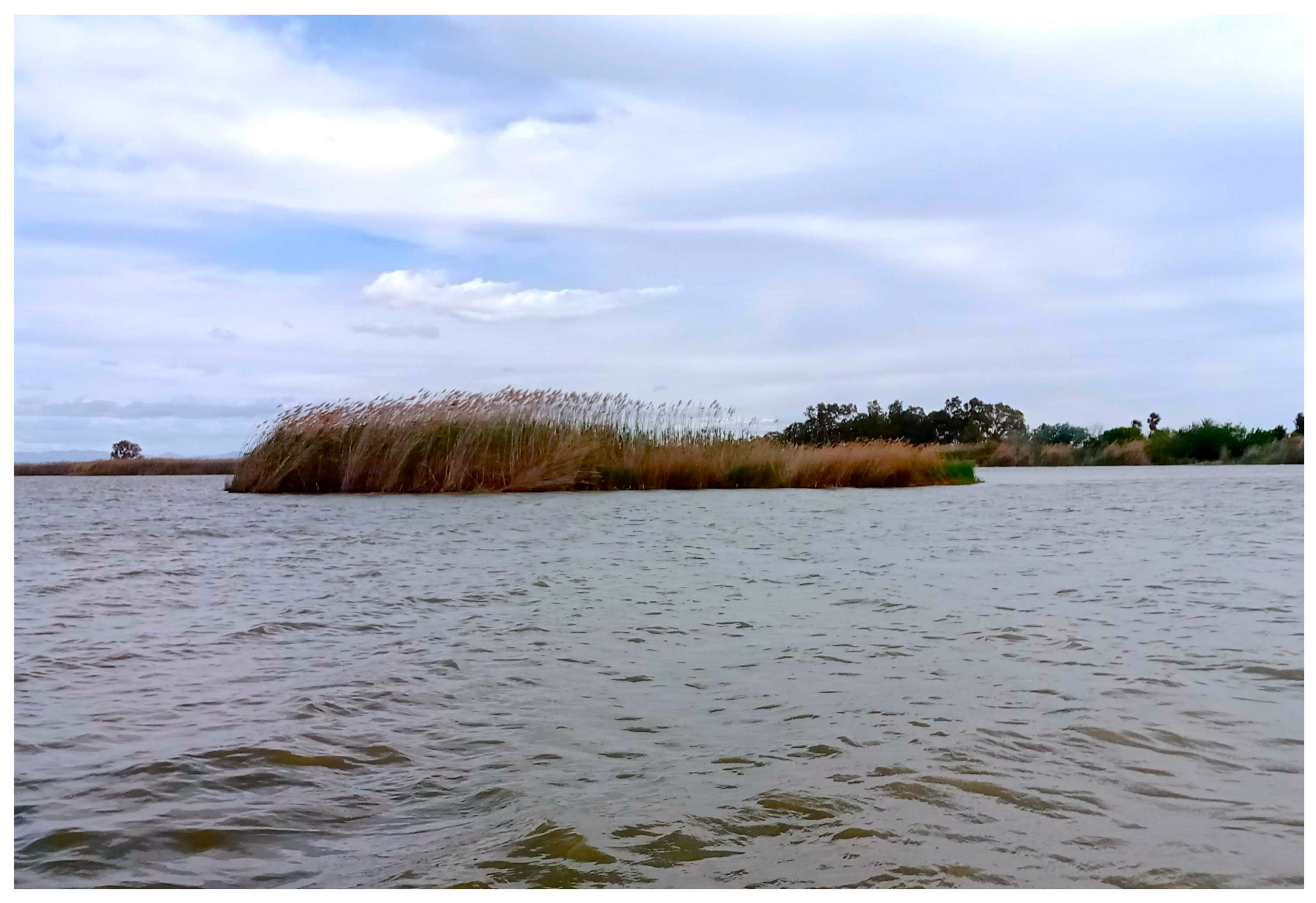
On 30 May 2024, field verification was conducted to confirm the location and density of A. donax stands. This field campaign was conducted in the lagoon areas where there are reeds by boat, accompanied by members of the El Palmar Fishermen’s Guild. The field campaign was acknowledged by the relevant stakeholders, including the El Palmar Fishermen, who possess interesting knowledge of the area where the reeds are located. Consequently, the locations remain consistent. It was also noted by fishermen that the reeds in the southern region, specifically in the En Torre area, were exhibiting accelerated growth in recent years, thereby impeding the navigability of the channels for boats. The objective of the campaign was to visually ascertain the density and approximate extent of the subject area, with georeferenced points serving as a reference. This experimental approach was employed to later determine the range of NDVI satellital index values that could be utilised for the purpose of differentiating between reeds and water in these regions. Photographs were taken to document the status of the A. donax cover at the different locations (Figure 2).
Figure 2. Image of A. donax and P. australis taken on 15 April 2025 near En Torre.

2.3. Remote Sensing Analysis

In order to map and quantify the cover of A. donax from 1996 to 2024, satellite images from Sentinel-2 and Landsat-5 were utilised, corresponding to the month of March, which is within the senescence period of these species [,]. The estimation of vegetation biomass and cover was based on the analysis of spectral data from satellite sensors. Vegetation indices were calculated using combinations of spectral bands to highlight the presence of vegetation and minimise the influence of soil or illumination effects []. Among the indices applicable to the Sentinel and Landsat series, the most widely used is the Normalised Difference Vegetation Index (NDVI), which exploits the contrast between near-infrared and red reflectance to estimate vegetation density and health []. Other indices, such as the Soil Adjusted Vegetation Index (SAVI) [] and the Leaf Area Index (LAI) [], were also considered during data interpretation to validate vegetation patterns and canopy structure. However, NDVI was selected as the main indicator for mapping A. donax due to its reliability and comparability with previous studies in the Albufera wetland.
The selection of this particular phenological period is based on the observation that A. donax and Phragmites australis ((Cav.) Trin. ex Steud., 1840 (hereafter P. australis, the native riparian grass of the area)) can be regarded as morphospecies, as they exhibit similar morphological characteristics: both are tall, perennial grasses with flowers arranged in dense plumes. This morphological similarity means that they are not spectrally distinguishable during the growing season by remote sensing [].
However, it is possible to differentiate between the two species’ spectra during the senescence period. The key to distinguishing between them during this period lies in their different states and spectral characteristics. During the senescence period, reed (P. australis) stands exhibit a change in colour to yellowish brown, along with a spectral signature that is atypical for vegetation. This is characterised by a low reflectance in the near-infrared region. This phenomenon could be interpreted as the reed ceasing to emit a signal or significantly reducing its active vegetation signal during this period [].
Conversely, within the same period of senescence, A. donax exhibits a mixture of green and yellowish-brown biomass. Despite the reduction in its physiological activity and the senescence of lower leaves towards the end of August and during the autumn months, with the onset of a period of vegetative rest in winter characterised by a typical brownish pigmentation, the presence of green biomass or the persistence of some activity enables the continued emission of a vegetation signal that differentiates it from the reed in its more advanced state of senescence [].
The analysis of these images was mainly based on the calculation of the Normalised Difference Vegetation Index (NDVI), considering that, as previously explained, the vegetation observed in March is predominantly A. donax and not P. australis. In the Sentinel-2 images, the index was applied and individual regions of interest (ROIs) were defined for each of the six stands of A. donax (La Barra, Fangaret, Manseguerota, San Roc, Pujol Vell, and En Torre). The identification of these regions of interest (ROIs) was facilitated by the use of polygons, which were employed to delimit the spatial distribution of each stand of reeds, as observed in the satellite images. Subsequently, different thresholds of the NDVI were tested to create masks that could differentiate giant reed (A. donax) stands from water, with the intention of finding a general threshold that would work for all images equally. This step was verified empirically in the most recent images by checking the extent of the resulting masks against the extent that had been observed visually in the field during the sampling campaign that visited the most affected areas.
The NDVI threshold of >0.2 was identified, coinciding with the threshold employed in previous studies for other species of plant in the lake, where species such as Myriophyllum spicatum had previously emerged in the Albufera to discriminate between aquatic plants. This value has been employed in numerous remote sensing studies as a reference for mapping semi-aquatic macrophytes.
Consequently, in this particular case, the implementation of comprehensive spectral calibration, the utilisation of spectral libraries, or radiometric field validation is deemed unnecessary, given the extensive knowledge of the study areas. Moreover, for this ecological and prescriptive study, it is not the primary objective to conduct a radiometric study or develop species-specific indices or thresholds when the beds are monospecific.
Sentinel-2 images were obtained from the Copernicus browser and had already been atmospherically corrected using the Sen2Cor processor (L2A level). Landsat-5 images were obtained from the US Geological Survey and atmospherically corrected with the Quick Atmospheric Correction (QUAC) method using ENVI 5.01 software. The image processing was performed utilising Sentinel Applications Platform 9.0 software (SNAP), which was developed by the European Space Agency (ESA).
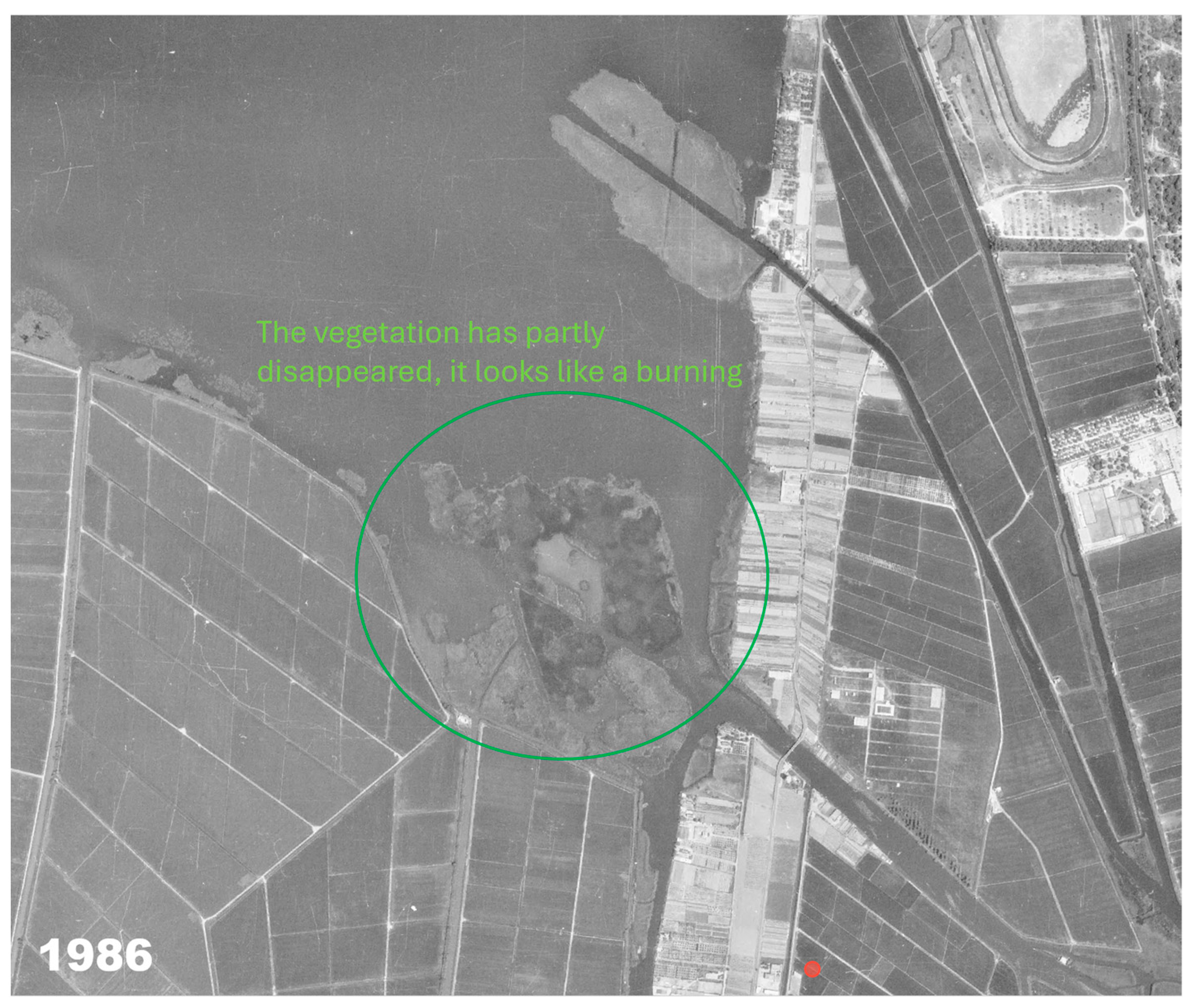
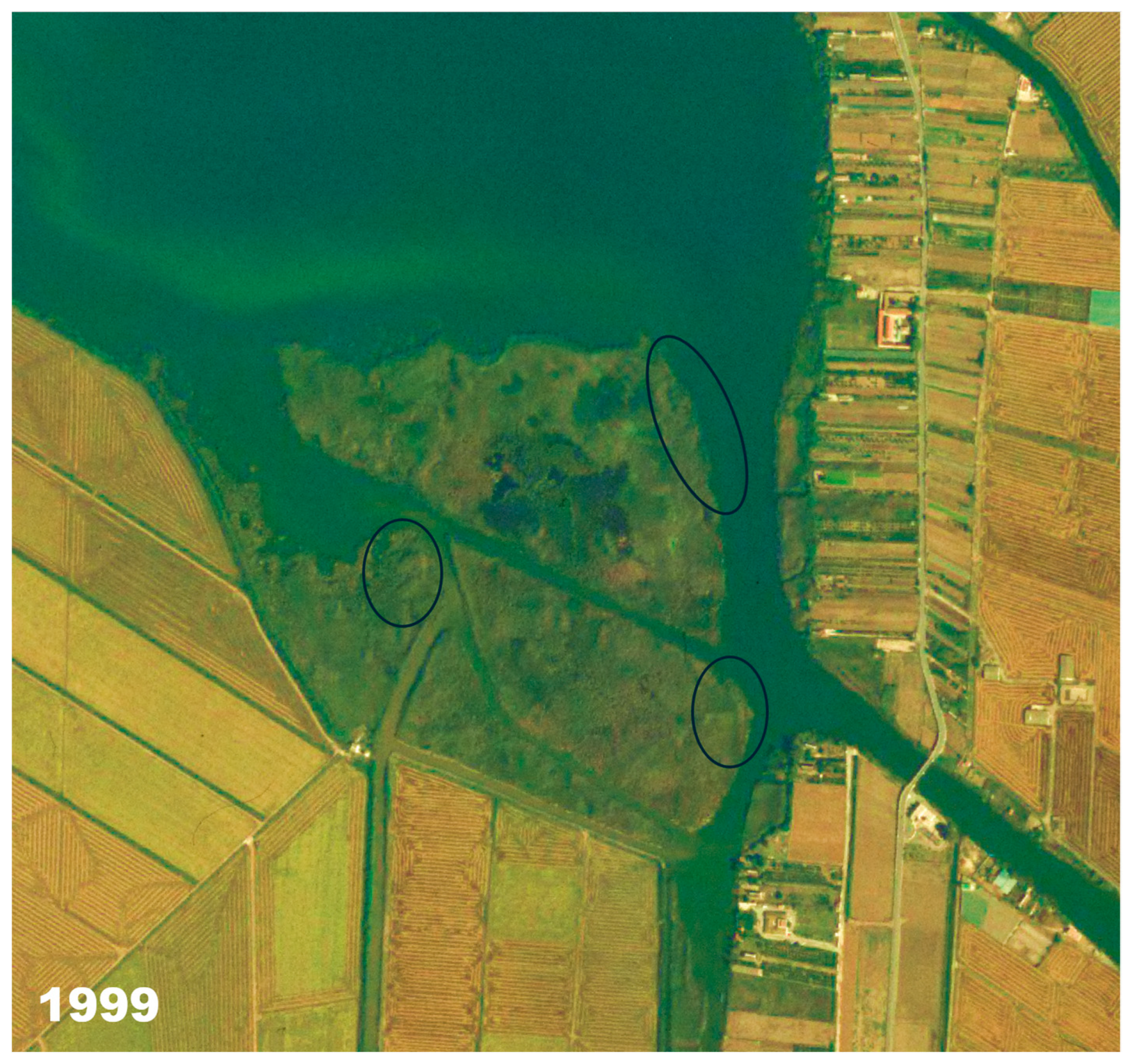
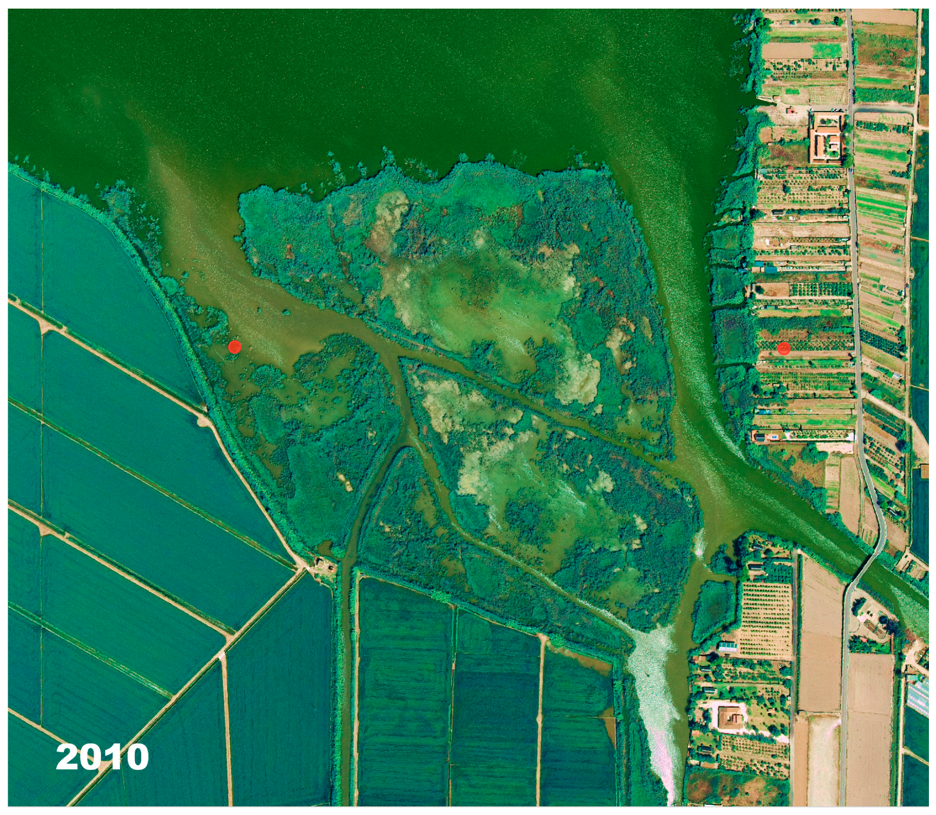
Furthermore, orthophotos were obtained from Spain’s National Geographic Institute (IGN) (see Appendix A), which were utilised exclusively as visual reference material to demonstrate that the extent of reeds in the period preceding the multispectral images was less than that observed at present. However, it should be noted that these images are of an aerial nature and thus contain only a visualisation of the territory; they do not consist of satellite or drone images with spectral information. Consequently, it was not possible to calculate quantitative statistics on accuracy or uncertainty from them. The inclusion of these data serves to illustrate the spatial correspondence between the maps derived from the NDVI and the visible presence of A. donax stands in different years.

2.4. Data Analysis

A statistical analysis of remotely sensed A. donax cover data was performed. Initially, the normality of the distribution of data per bush and for the total cover was assessed. In order to analyse temporal trends in A. donax cover, the non-parametric Mann–Kendall test was applied to the time series for each shrub and for the total area covered, considering different periods (1996–2024, 1996–2011, and 2011–2024). Statistical analyses were implemented utilising PAST 4.11 software.

3. Results

3.1. Remote Sensing

A. donax has been studied for its presence in historical images obtained from photogrammetric flights, the first being from 1948 and later in 1956 and so on until 2021. In the images obtained, the presence of this plant has been visually identified, differentiating it from others such as P. australis by its size and coloration. On the other hand, since 1996 it has been studied by means of satellite images which have been processed by applying the NDVI. The result is an increment of the occupied surface, being imperceptible in the first scenes, with the first areas seen in the 1989 image. By 1996, 91 ha had already been evaluated, with a decrease to a minimum value in 2011 with 62 ha, and increasing again until an estimated area of 83 ha in 2024.
As illustrated in Table 1, the values of A. donax cover are represented in hectares for each of the six stands (En Torre, Barra, Fangaret, Manseguerota, San Roc, Pujol Vell), in addition to the total cover, on different dates from Landsat-5 and Sentinel-2 satellites.
Table 1. The area (ha) of shrublands for each individual site, and the total area for the period between 1996 and 2024.
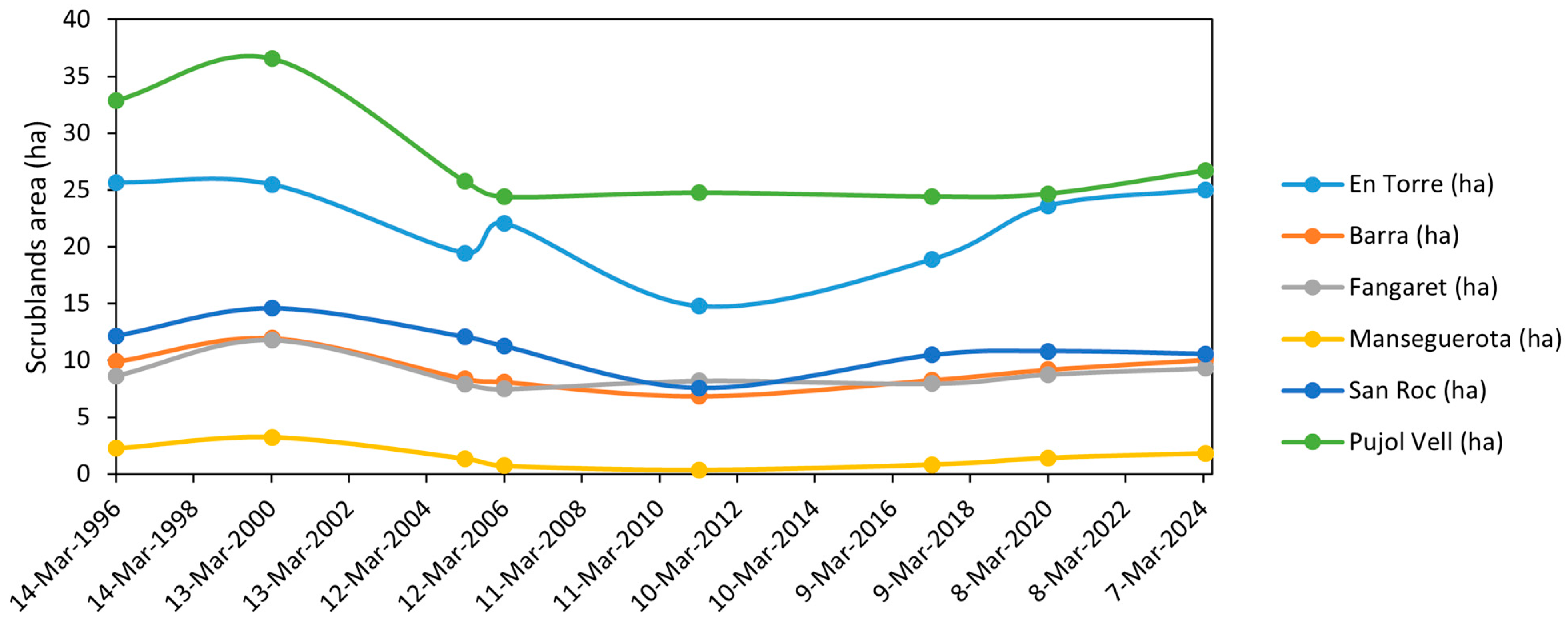
As illustrated in Figure 3, observations of A. donax cover were obtained from the six study sites during eight representative periods between 1996 and 2024. The graph below illustrates the temporal changes in A. donax cover over the period studied.
Figure 3. The following graph illustrates the temporal evolution of the area of A. donax in the six study shrublands between 1996 and 2024.

3.2. Multivariate Statistics

The data normality test (Table 2) revealed that all the shrubs followed a normal distribution, apart from Manseguerota and Pujol Vell.
Table 2. The results of the Shapiro–Wilk normality test (n.s.: non significative).
The Mann–Kendall trend analysis (Table 3) for the period 1996–2024 indicated that, considering the total hectares covered by reeds in the study stands, there is no significant trend. However, a significant decreasing trend in total cover was observed when the period 1996–2011 was analysed. However, during the period 2011–2024, a significant increasing trend in total cover was detected.
Table 3. Results of the Mann–Kendall trend analysis (n.s.: non significative).
At the individual stand level, during the period 1996–2011, a decline was observed in all stands, with the exception of Fangaret and Pujol Vell. For the period 2011–2024, three of the four stands that had declined in the previous period (Torre, Barra, and Manseguerota) demonstrated a statistically significant increasing trend. The three main stands are located in the southern part of the lagoon.

4. Discussion

Given the high rate of growth exhibited by the reeds, it can be harvested on a regular basis, thereby ensuring a constant supply of this raw material []. Studies conducted in other regions corroborate the trends observed in the Albufera wetland. In the Mediterranean basin, A. donax has similarly expanded along riparian corridors in Italy and southern France, forming dense monocultures that displace native species and alter river hydrology [,]. Outside Europe, large-scale invasions have been documented in California and Mexico, where A. donax replaces native willow and cottonwood stands, which increases evapotranspiration and modifies sedimentation processes [,]. These parallels indicate that the proliferation of A. donax is favoured by similar environmental drivers (disturbance, high nutrient availability, and warm temperate climates) and that management experiences from these regions may inform control strategies in Mediterranean wetlands. In areas where it was abundant, it was utilised for a variety of purposes, including agriculture (as fodder or bedding for livestock), construction (roofing, walls, panelling, fish traps, among others), horticulture (mats to protect crops from wind or frost, fencing), industry (pulp and paper production), and power generation (as fuel) [,,]. Its utilisation in construction can be traced back to prehistoric times, when it was employed in the construction of structures such as traditional roofs [,].
Nowadays, its potential as a renewable material has attracted the interest of numerous researchers, who are incorporating it in various applications within the field of sustainable construction [,]. The giant reed has become a prominent choice as a green building material due to its low environmental impact and health benefits [,]. The thermal properties of this material, in conjunction with its renewability and non-toxic nature, have been demonstrated to enhance the energy efficiency of buildings and to help prevent sick building syndrome [,]. The achievement of Leadership in Energy and Environmental Design certifications (LEED) [,] has been facilitated, along with other agricultural by-products such as straw and bagasse according to Sobhy et al. [] and Laborel-Préneron et al. [].
The reedbed is indicative of an initial stage in the ecological succession from water bodies to forests. In the absence of management, the vegetation tends to undergo desiccation and is replaced by scrub and woodland, resulting in a loss of biodiversity and thatch quality []. The implementation of management strategies, such as slashing, burning, or grazing, has been identified as a method to mitigate the effects of succession and to conserve specific habitats, including those essential for species such as bitterns and bearded vultures [,]. The practice of regular burning is a widespread one in Mediterranean reedbeds, including those located within wetlands that are protected under the Ramsar Convention []. The impact of reed cutting on invertebrate species is variable. In some cases, it has been observed to reduce the population of certain species; however, in other instances, it has been demonstrated to increase the population or have no significant effect []. In the context of birds, this phenomenon is frequently negative, as it has been observed to hinder nesting and increase predation rates []. However, the opposite is true in terms of the benefit to plant diversity [].
It is evident that a significant number of Mediterranean freshwater wetlands have experienced a decline in depth, primarily due to excessive water abstraction for irrigation purposes, a situation that is exemplified by Lake Cheimaditis in Greece. This has resulted in the proliferation of reed beds and the consequent loss of biodiversity and fisheries value. In order to restore the ecosystem, it is proposed that the water level be increased by limiting its abstraction and improving its input into the lake. This would favour the return of currently rare or absent aquatic flora species [].
Large invasive grasses, in particular, have been observed to form extensive monocultures in rivers and associated wetlands, and often share characteristics that facilitate their colonisation and long-term dominance []. These characteristics include their predominantly vegetative reproductive life cycle and their marked ability to establish in systems where abiotic conditions have been altered [].
In this regard, urbanisation and agricultural practices in Mediterranean climate catchments have played a key role in profoundly altering natural flow regimes and significantly increasing nutrient inputs to these ecosystems [,]. The alteration of environmental conditions, particularly the excess of nutrients and the disruption of the hydrological regime, has been identified as a key factor in the proliferation of invasive species. These species have been shown to utilise the new conditions to displace native vegetation and become established as dominant species []. This process could be considered a consequence of climate change.
Although A. donax is generally believed to be dispersed mainly by fragments generated during floods, it has been shown that bulldozers, by damaging rhizomes during canal maintenance, generate significantly more new shoots downstream than those observed under natural conditions. This finding suggests that floods rarely effectively fragment rhizomes, and that mechanical activities, such as bulldozing, play a key role in their spread. It is therefore recommended that good management practices be implemented when operating machinery in areas where A. donax is present, and that its use be avoided when attempting to eradicate it [].
The implementation of more effective management and control measures is essential to mitigate the impact of A. donax in freshwater ecosystems. The challenge in eradicating this species is due to its morphology, vegetative growth, physiology, and high ecological tolerance. A significant number of control actions have proven unsuccessful due to an exclusive emphasis on the immediate removal of symptoms. A range of methods have been employed, including the use of herbicides, logging, biological control, and ecological approaches. However, the effectiveness of these methods is yet to be optimised, and further research is required to enhance our understanding of the invasive behaviour of the species []. In Europe, the promotion of biological control as a component of integrated management programmes is strongly recommended. These programmes should also incorporate technological advancement, the involvement of managers, knowledge transfer with stakeholders, and political support []. It is essential to develop specific programmes that delve deeper into the biology of A. donax and optimise control strategies [], in addition to the selective elimination and reintroduction of native species [].
Within the geographical limits of the Júcar river basin (eastern Spain), A. donax has been observed in a multitude of watercourses, with a higher frequency recorded in the easternmost and southernmost regions []. The definitive control of A. donax is complex, requiring the removal of the underground rhizome. Conventional techniques such as clearing or surface burning have been demonstrated to be ineffective for achieving definitive control. Indeed, in the medium term, these methods result in the consolidation of dominance by the common reed, as they do not affect the rhizome and permit faster regrowth than that of native vegetation. The sources consulted, based on experiences up to 2011, explicitly condemn burning as a control method, indicating that it could only be justified to reduce biomass in emergencies, but it can be assumed that it aggravates the invasion in the long term []. It is essential to differentiate between this and the control group. In the Albufera Natural Park, the Generalitat Valenciana (regional government), through the Park’s Technical Management Office, has implemented a programme of work to eradicate exotic and invasive vegetation. The 2012 Albufera Natural Park Management Report shows that 111 m3 of A. donax were extracted that year, which constituted the majority of the total volume of exotic vegetation extracted (187 m3). The actions were carried out in specific enclaves such as coastal areas, the Devesa, and areas on the southeastern shore of the lagoon []. In 2013, the removal of exotic flora was planned to continue.
In comparison to the 2012 Management Report, the 2021 Management Report of the Albufera Natural Park does not provide specific quantitative data on A. donax removal for that year. The 2021 report [] provides a detailed account of a wide range of management activities, including water quality monitoring (which revealed persistent high levels of eutrophication), species monitoring (e.g., birds, macroinvertebrates, fish, bivalves, showing significant declines in native species such as bivalves and river blenny), rice straw management, and general conservation and maintenance work. As is evident in the literature, actions against other aquatic invasive species such as Azolla filiculoides and Ludwigia grandiflora are mentioned. However, the absence of a quantified summary of the removal of A. donax in 2021, as was the case in 2012, makes it difficult to directly assess the effort devoted to this species. However, authorisations for phytosanitary treatments are recorded, although it is not specified whether these were for A. donax.
With regard to the trends in A. donax cover in the Albufera lagoon stands, the data from this study show a significant decrease between 1996 and 2011, followed by a statistically significant increase between 2011 and 2024, particularly in stands in the south of the lagoon (Torre, Barra, Manseguerota). With the absence of significant climatic trends in temperature or rainfall in the last decade [], the explanation for this change in trend could be explained by the difficulty of achieving eradication, which increases with the scale of the intervention. While the 2012 report [] indicates a specific effort to eradicate A. donax, the absence of similar data in the 2021 report [] could be indicative of a possible decrease or discontinuity in the intensity of effective control programmes (which focus on the rhizome) after 2011, or perhaps a change in reporting strategy. A reduction in monitoring and reworking, which is crucial to prevent proliferation and recolonisation, especially in previously treated areas, could explain the observed rebound. The increasing trend from 2011 to 2024 is consistent with the hypothesis that sustained control efforts, which may have contributed to the previous decline (1996–2011), were not maintained with the same intensity or focus in the subsequent period.
The dense and continuous stands of A. donax observed in the southern channels of the Albufera wetland may also influence local hydrodynamics. Previous studies have reported that the accumulation of rhizomes and stems in waterways can obstruct flow, increase sedimentation, and locally raise flood susceptibility [,]. Although the present study did not include hydrodynamic or geomorphological modelling, the field observations and stakeholder reports from 2024 confirm that dense A. donax growth hindered boat passage through the canals, suggesting a potential effect on water conveyance. Further research combining remote sensing and hydraulic modelling would be necessary to quantify this relationship.
A few methodological limitations should be acknowledged. The NDVI threshold applied in this study was effective for detecting A. donax within specific regions of interest (ROIs) where the species presence had been previously verified in the field. However, this threshold may not be directly transferable to heterogeneous wetland areas containing multiple macrophyte species with overlapping spectral responses. Moreover, not all management or monitoring reports were available for the entire 1996–2024 period, which may introduce minor uncertainties in the interpretation of temporal patterns. Despite these limitations, the reliability of the remote sensing analysis was supported by field verification carried out in May 2024, when the main A. donax patches were revisited to confirm their location and approximate extent, allowing the subsequent validation of the NDVI-derived maps. Future research should explicitly focus on remote sensing applications and their potential to refine species-specific NDVI ranges and comparing alternative indices (e.g., EVI, NDWI). In this study, the Normalised Difference Vegetation Index (NDVI) was utilised not for supervised or multi-class classification, but as a continuous index to identify areas with dense A. donax cover within predefined regions of interest (ROIs). Empirical verification was performed by overlaying NDVI masks on known A. donax polygons identified during field studies and through orthophotos. This qualitative comparison confirmed that the threshold (NDVI > 0.2) effectively distinguished vegetation from open water and bare soil within the ROIs.
The selection of effective control methods (e.g., the mechanical removal of the rhizome, the repeated application of systemic herbicides, opaque cover, or flooding) is determined by variables such as species biology, reed bed type, proximity to water, and budget. A comprehensive strategy should include the restoration of native riparian communities to prevent further invasions after reed removal [].
In order to achieve effective and sustainable management of A. donax in the Albufera Natural Park, it is essential to recognise the need to focus on the underground rhizome in order to achieve definitive control. Ineffective methods such as surface burning or simple clearing must be avoided, as these have been shown to worsen the issue of invasion. It is critical to remove the rhizome, and this can be achieved through mechanical removal, repeated weeding, or systemic herbicides applied according to regulations, especially in proximity to water sources. The introduction of the common reed has been demonstrated to have a number of significant consequences for the local environment. Firstly, it has been shown to displace native vegetation and increase the risk of fire. Secondly, it has been demonstrated to have a considerable negative impact on hydrology and fluvial geomorphology, acting as bank walls and forming dams that block channels and flood control structures during floods, with serious consequences. This makes their elimination essential for the recovery of the good ecological status of river systems and the prevention of flood risk. A fundamental pillar of this approach is the establishment of long-term monitoring and review programmes, which are essential for 3 to 5 years following the initial treatment to consolidate effectiveness and prevent rebound. In this regard, remote sensing has been identified as a valuable tool for the effective monitoring of the dynamics of A. donax cover, thereby facilitating the planning of these surveys. It is recommended that areas of action be prioritised according to risk and impact, with a focus on the shrubs located in the southern region of the lagoon and the canals. Following the implementation of effective control measures, it is crucial to actively restore the habitat through the introduction of native vegetation, such as willows. These plants have been shown to compete with resprouts, thereby contributing to the recovery of the affected habitat. The enhancement of inter-administrative coordination (regional government, Jucar Basin Authority, city councils) and the dissemination of the advantages of control, including the mitigation of flood risk, to the local population are fundamental to ensuring long-term viability.

5. Conclusions

In conclusion, the results of this study reveal a worrying dynamic in the invasion of A. donax in the Albufera, showing two distinct phases: a decreasing trend in coverage between 1996 and 2011, followed by a clear upturn and increasing trend from 2011 to 2024. The total area occupied by the species decreased from 91.4 ha in 1996 to 62.5 ha in 2011 (−31.6%), followed by an increase to 83.5 ha in 2024 (+33.6%). The Mann–Kendall test confirmed a significant decreasing trend during 1996–2011 and a subsequent increasing trend during 2011–2024 (p < 0.05). This pattern suggests that previous management efforts, which were responsible for the initial decline, were not sustained over time or were insufficient to achieve definitive control, allowing the species to expand further. Remote sensing demonstrated high potential for the long-term ecological monitoring of invasive vegetation in Mediterranean wetlands.

Author Contributions

Conceptualization, M.J.-C. and J.M.S.; methodology, J.V.M.; validation, J.M.S.; formal analysis, J.M.S.; investigation, J.V.M. and N.C.-T.; data curation, J.V.M.; writing—original draft preparation, J.V.M. and N.C.-T.; writing—review and editing, J.M.S., N.C.-T., J.V.M. and M.J.-C.; supervision, J.M.S. All authors have read and agreed to the published version of the manuscript.

Funding

This research received funding from the University of Valencia (research grant 70230401: Limnological monitoring of quality in aquatic ecosystems).

Data Availability Statement

The original contributions presented in this study are included in the article. Further inquiries can be directed to the corresponding author. The aerial orthophotos used in Appendix A were obtained from the Instituto Geográfico Nacional (https://ign.es, accessed on 10 August 2025) under an open-access licence. The licencing and data access for these images were managed by J.M.S., who holds the corresponding licence for research use.

Acknowledgments

The authors would like to express their gratitude to the El Palmar Fishermen’s Guild (Valencia, Spain) for their collaboration in providing boat transport during the visual exploration of the reeds, as well as for their ongoing commitment over the last 775 years to sustainable activities in the Albufera Natural Park and their activism to improve the ecological quality of its ecosystems. Landsat-8 images can be downloaded from https://earthexplorer.usgs.gov/ (accessed on 25 May 2025) and are used for research purposes by licence to J.S.

Conflicts of Interest

The authors declare no conflicts of interest.

Appendix A

In this appendix, we present some orthophotos from several different years obtained from the Download Center of the National Geographic Information Center (CNIG), which is attached to the National Geographic Institute (IGN) of Spain (https://centrodedescargas.cnig.es/, accessed on 10 August 2025). They illustrate how the proliferation of reeds in this region is a recent phenomenon.
Note: The orthophotos included in this Appendix are RGB aerial images used for the qualitative visual validation of the NDVI results. They do not contain spectral or radiometric data, and thus no uncertainty or accuracy metrics can be derived from them.
Figure A1. Extension of vegetation in the “En Torre” shrubland area (the most affected one, near El Palmar) in 1948. Red circle marks the last original vegetation area transformed into rice fields, making a wall, road, and channel.
Figure A2. Extension of vegetation in the “En Torre” shrubland in 1956. Red circle marks the newly constructed rice field.
Figure A3. Extension of vegetation in the “En Torre” shrubland in 1976. Rice fields located in red circle disappear and are transformed into orchards.
Figure A4. Extension of vegetation in the “En Torre” shrubland in 1986. In the sand area, the vegetation has reduced probably due to the burning of plants.
Figure A5. Beginning of the extension of the giant reed in the “En Torre” shrubland in 1989, marked with the black circle.
Figure A6. Augmentation of the extension of the giant reed in the “En Torre” shrubland in 1999, marked with the black circle.
Figure A7. The giant reed in the “En Torre” shrubland in 2006, which covers the outer edge of the previous sand area.
Figure A8. The giant reed in the “En Torre” shrubland in 2010, which covers all of the outer edge of the area.
Figure A9. The giant reed in the “En Torre” shrubland in 2021, which covers more than the outer edge and reduces the width of the channels.

References

  1. Simberloff, D. Sustainability of biodiversity under global changes, with particular reference to biological invasions. In Sustainability Science: The Emerging Paradigm and the Urban Environment; Weinstein, M., Turner, E., Eds.; Springer: New York, NY, USA, 2012; pp. 139–157. Available online: https://link.springer.com/book/10.1007/978-1-4614-3188-6 (accessed on 4 April 2025).
  2. McGeoch, M.A.; Butchart, S.H.M.; Spear, D.; Marais, E.; Kleynhans, E.J.; Symes, A.; Chanson, J.; Hoffmann, M. Global indicators of biological invasion: Species, numbers, biodiversity impact and policy responses. Divers. Distrib. 2010, 16, 95–108. [Google Scholar] [CrossRef]
  3. Myers, N.; Mittermeier, R.A.; Fonseca, G.A.B.; Kent, J. Biodiversity hotspots for conservation priorities. Nature 2000, 403, 853–858. [Google Scholar] [CrossRef]
  4. Cuttelod, A.; García, N.; Malak, D.A.; Templeand, H.; Vineet, K. The Mediterranean: A Biodiversity Hotspot under Threat. In The 2008 Review of The IUCN Red List of Threatened Species; Vié, J.-C., Hilton-Taylor, C., Stuart, S.N., Eds.; IUCN: Gland, Switzerland, 2019; Available online: https://iucn.org/sites/default/files/import/downloads/the_mediterranean_a_biodiversity_hotspot_under_threat.pdf (accessed on 7 July 2025).
  5. Al Hassan, M.; Boscaiu, M.; Mayoral, O. Competition between halophytes and invasive species: Dittrichia viscosa and Limbarda crithmoides: A Study Case from the Valencian Salt Marshes. In Handbook of Halophytes: From Molecules to Ecosystems Towards Biosaline Agriculture; Springer International Publishing: Cham, Switzerland, 2021; pp. 599–621. [Google Scholar] [CrossRef]
  6. Ley 11/1994, de 27 de Diciembre, de Espacios Naturales Protegidos de la Comunidad Valenciana. Available online: https://www.boe.es/eli/es-vc/l/1994/12/27/11 (accessed on 7 July 2025).
  7. Soria, J.M. Past, present and future of La Albufera of Valencia Natural Park. Limnetica 2006, 25, 135–142. [Google Scholar] [CrossRef]
  8. Bolòs, O.D.; Vigo, A. Flora dels Països Catalans, 2nd ed.; Editorial Barcino: Barcelona, España, 2001; Volume I (Monocotiledònies), Available online: https://publicacions.iec.cat/repository/pdf/00000300/00000020.pdf (accessed on 7 July 2025).
  9. Häfliger, E.; Scholz, H. Grass Weeds 2, Weeds of the Subfamilies Chloridoideae, Pooideae, Oryzoideae; Documenta Ciba-Geigy: Basel, Switzerland, 1981; pp. 32–45. [Google Scholar]
  10. Dudley, T.L. Arundo donax L. In Invasive Plants of California’s Wildlands; Bossard, C.C., Randall, J.M., Hoshovsky, M.C., Eds.; University of California Press: Berkeley, CA, USA, 2000; pp. 53–58. [Google Scholar]
  11. Bell, G.P. Biology and growth habits of giant reed (Arundo donax). In Arundo donax Workshop Proceedings; Jackson, N.E., Frandsen, P., Douthit, S., Eds.; California Exotic Pest Plant Council (CalEPPC): Pismo Beach, CA, USA, 1993; pp. 1–6. Available online: https://www.cal-ipc.org/docs/symposia/archive/pdf/Arundo_Proceedings_1993.pdf (accessed on 7 July 2025).
  12. Lambert, A.M.; Dudley, T.L.; Saltonstall, K. Ecology and impacts of the large-statured invasive grasses Arundo donax and Phragmites australis in North America. Invasive Plant Sci. Manag. 2010, 3, 489–494. [Google Scholar] [CrossRef]
  13. Jiménez-Ruiz, J.; Hardion, L.; Del Monte, J.P.; Vila, B.; Santín-Montanyá, M.I. Monographs on invasive plants in Europe N° 4: Arundo donax L. Bot. Lett. 2021, 168, 131–151. [Google Scholar] [CrossRef]
  14. Madsen, J.D.; Chambers, P.A.; James, W.F.; Koch, E.W.; Westlake, D.F. The interaction between water movement, sediment dynamics and submersed macrophytes. Hydrobiologia 2001, 444, 71–84. [Google Scholar] [CrossRef]
  15. Schoelynck, J.; De Groote, T.; Bal, K.; Vandenbruwaene, W.; Meire, P.; Temmerman, S. Self-organised patchiness and scale-dependent bio-geomorphic feedbacks in aquatic river vegetation. Ecography 2012, 35, 760–768. [Google Scholar] [CrossRef]
  16. Bal, K.D.; Bouma, T.J.; Buis, K.; Struyf, E.; Schoelynck, J.; Backx, H.; Meire, P. Trade-off between drag reduction and light interception of macrophytes: Comparing five aquatic plants with contrasting morphology. Funct. Ecol. 2011, 25, 1197–1205. [Google Scholar] [CrossRef]
  17. De Doncker, L.; Troch, P.; Verhoeven, R.; Bal, K.; Desmet, N.; Meire, P. Relation between resistance characteristics due to aquatic weed growth and the hydraulic capacity of the river Aa. River Res. Appl. 2009, 25, 1287–1303. [Google Scholar] [CrossRef]
  18. Tracy, J.L.; DeLoach, C.J. Biological control of saltcedar in the United States: Progress and projected ecological effects. In Arundo and Saltcedar: The Deadly Duo; Bell, C.E., Ed.; U.C. Cooperative Extension Service: Riverside, CA, USA, 1999; pp. 111–154. [Google Scholar]
  19. El Confidencial. Las Cañas Que Invaden Ríos y Barrancos son una Trampa Mortal. Available online: https://www.elconfidencial.com/medioambiente/agua/2024-12-19/canas-barrancos-riadas-dana-especies-invasoras_4025733/ (accessed on 7 April 2025).
  20. Boon, P.J.; Holmes, N.T.H.; Raven, P.J. Developing standard approaches for recording and assessing river hydromorphology: The role of the European Committee for Standardization (CEN). Aquat. Conserv. Mar. Freshw. Ecosyst. 2010, 20, 55–61. [Google Scholar] [CrossRef]
  21. Schmutz, S.; Cowx, I.; Haidvogl, G.; Pont, D. Fish-based methods for assessing European running waters: A synthesis. Fish. Manag. Ecol. 2007, 14, 369–380. [Google Scholar] [CrossRef]
  22. Kettunen, M.; Genovesi, P.; Gollasch, S.; Pagad, S.; Starfinger, U.; ten Brink, P.; Shine, C. Technical Support to EU Strategy on Invasive Species (IAS)—Assessment of the Impacts of IAS in Europe and the EU (Final Module Report for the European Commission); Institute for European Environmental Policy (IEEP): Brussels, Belgium, 2008; Available online: https://www.actu-environnement.com/media/pdf/news-27629-ieep-etude.pdf (accessed on 7 July 2025).
  23. Cardoso, A.C.; Free, G. Incorporating invasive alien species into ecological assessment in the context of the Water Framework Directive. Aquat. Invasions 2008, 3, 361–366. [Google Scholar] [CrossRef]
  24. Carpenter, G.A.; Gopal, S.; Macomber, S.; Martens, S.; Woodcock, C.E. A Neural Network Method for Mixture Estimation for Vegetation Mapping. Remote Sens. Environ. 1999, 70, 139–152. [Google Scholar] [CrossRef]
  25. He, C.; Zhang, Q.; Li, Y.; Li, X.; Shi, P. Zoning grassland protection area using remote sensing and cellular automata modeling—A case study in Xilingol steppe grassland in northern China. J. Arid Environ. 2005, 63, 814–826. [Google Scholar] [CrossRef]
  26. Polunin, O.; Huxley, A. Flowers of the Mediterranean; Hogarth Press: London, UK, 1987; Available online: http://www.marelibri.com/topic/3290534-main/books/AUTHOR_AZ/14300?l=en (accessed on 7 July 2025).
  27. Zeven, A.C.; de Wet, J.M.J. Dictionary of Cultivated Plants and Their Centres of Diversity: Excluding Most Ornamentals, Forest Trees and Lower Plants; CAPD: Wageningen, The Netherlands, 1982; Available online: https://edepot.wur.nl/318076 (accessed on 7 July 2025).
  28. Ewel, K.; Cressa, C.; Kneib, R.; Levin, L.; Palmer, M.; Snelgrove, P.; Wall, D. Managing Critical Transition Zones. Ecosystems 2001, 4, 452–460. [Google Scholar] [CrossRef]
  29. Hood, W.G.; Naiman, R.J. Vulnerability of riparian zones to invasion by exotic vascular plants. Plant Ecol. 2000, 148, 105–114. [Google Scholar] [CrossRef]
  30. Richardson, D.M.; Holmes, P.M.; Esler, K.J.; Galatowitsch, S.M.; Stromberg, J.C.; Kirkman, S.P.; Pyšek, P.; Hobbs, R.J. Riparian vegetation: Degradation, alien plant invasions, and restoration prospects. Divers. Distrib. 2007, 13, 126–139. [Google Scholar] [CrossRef]
  31. PlantNet. Arundo donax L. Available online: https://identify.plantnet.org/es/k-world-flora/species/Arundo%20donax%20L./data (accessed on 12 May 2025).
  32. PlantNet. Phragmites australis (Cav.) Trin. ex Steud. Available online: https://identify.plantnet.org/es/k-world-flora/species/Phragmites%20australis%20(Cav.)%20Trin.%20ex%20Steud./data#section-phenology (accessed on 8 May 2025).
  33. Soria, J.M.; Molner, J.V.; Pérez-González, R.; Alvado, B.; Vera-Herrera, L.; Romo, S. Monitoring the Extraordinary Ephemeral Emergence of Myriophyllum spicatum L. in the Coastal Lagoon Albufera of Valencia (Spain) and Assessing the Impact of Environmental Variables Using a Remote Sensing Approach. J. Mar. Sci. Eng. 2024, 12, 260. [Google Scholar] [CrossRef]
  34. Tucker, C.J. Red and photographic infrared linear combinations for monitoring vegetation. Remote Sens. Environ. 1979, 8, 127–150. [Google Scholar] [CrossRef]
  35. Huete, A.R. A Soil-Adjusted Vegetation Index (SAVI). Remote Sens. Environ. 1988, 25, 295–309. [Google Scholar] [CrossRef]
  36. Chen, J.M.; Black, T.A. Defining leaf-area index for non-flat leaves. Plant Cell Environ. 1992, 15, 421–429. [Google Scholar] [CrossRef]
  37. Fernandes, M.R.; Aguiar, F.C.; Silva, J.M.; Ferreira, M.T.; Pereira, J.M. Spectral discrimination of giant reed (Arundo donax L.): A seasonal study in riparian areas. ISPRS J. Photogramm. Remote Sens. 2013, 80, 80–90. [Google Scholar] [CrossRef]
  38. Berardi, U.; Iannace, G. Acoustic characterization of natural fibers for sound absorption applications. Build. Environ. 2015, 94, 840–852. [Google Scholar] [CrossRef]
  39. Boland, J.M. The importance of layering in the rapid spread of Arundo donax (giant reed). Madroño 2006, 53, 303–312. [Google Scholar] [CrossRef]
  40. Quinn, L.D.; Allen, D.J.; Stewart, J.R. Environmental Tolerance and Biomass Potential of Arundo donax in Subtropical Regions. Ind. Crops Prod. 2015, 76, 1000–1008. [Google Scholar] [CrossRef]
  41. Haslam, S.M. A Book of Reed: (Phragmites australis (Cav.) Trin. ex Steudel, Phragmites communis Trin.); Forrest Text; Cardigan: Wales, UK, 2010. [Google Scholar]
  42. Köbbing, J.F.; Thevs, N.; Zerbe, S. The utilisation of reed (Phragmites australis): A review. Mires Peat 2013, 13, 1–14. [Google Scholar] [CrossRef]
  43. Thevs, N.; Zerbe, S.; Gahlert, F.; Mijit, M.; Succow, M. Productivity of reed (Phragmites australis Trin. ex. Staud.) in continental-arid NW China in relation to soil, groundwater, and land use. J. Appl. Bot. Food Qual. 2007, 81, 62–68. [Google Scholar]
  44. Martínez Gabarrón, A.; Flores Yepes, J.A.; Pastor Pérez, J.J.; Berná Serna, J.M.; Arnold, L.C.; Sánchez Medrano, F.J. Increase of the flexural strength of construction elements made with plaster (calcium sulfate dihydrate) and common reed (Arundo donax L.). Constr. Build. Mater. 2014, 66, 436–441. [Google Scholar] [CrossRef]
  45. Bołtryk, M.; Pawluczuk, E. Properties of a lightweight cement composite with an ecological organic filler. Constr. Build. Mater. 2014, 51, 97–105. [Google Scholar] [CrossRef]
  46. Ismail, Z.Z.; Jaeel, A.J. A novel use of undesirable wild giant reed biomass to replace aggregate in concrete. Constr. Build. Mater. 2014, 67, 68–73. [Google Scholar] [CrossRef]
  47. Khabaz, A. Construction and design requirements of green buildings’ roofs in Saudi Arabia depending on thermal conductivity principle. Constr. Build. Mater. 2018, 186, 1119–1131. [Google Scholar] [CrossRef]
  48. Sobhy, I.; Brakez, A.; Benhamou, B. Analysis for Thermal Behavior and Energy Savings of a Semi-Detached House with Different Insulation Strategies in a Hot Semi-Arid Climate. J. Green Build. 2017, 12, 78–106. [Google Scholar] [CrossRef]
  49. Yu, C.; Crump, D. A review of the emission of VOCs from polymeric materials used in buildings. Build. Environ. 1998, 33, 357–374. [Google Scholar] [CrossRef]
  50. Barreca, F.; Martinez Gabarron, A.; Flores Yepes, J.A.; Pastor Pérez, J.J. Innovative Use of Giant Reed and Cork Residues for Panels of Buildings in Mediterranean Area. Resour. Conserv. Recycl. 2019, 140, 259–266. [Google Scholar] [CrossRef]
  51. Prusty, J.; Patro, S.; Basarkar, S. Concrete using agro-waste as fine aggregate for sustainable built environment—A review. Int. J. Sustain. Built Environ. 2016, 5, 312–333. [Google Scholar] [CrossRef]
  52. McCormick, K.; Kautto, N. The bioeconomy in Europe: An overview. Sustainability 2013, 5, 2589–2608. [Google Scholar] [CrossRef]
  53. Laborel-Préneron, A.; Aubert, J.; Magniont, C.; Tribout, C.; Bertron, A. Plant aggregates and fibers in earth construction materials: A review. Constr. Build. Mater. 2016, 111, 719–734. [Google Scholar] [CrossRef]
  54. Hawke, C.J.; Jose, P.V. Reedbed Management for Commercial and Wildlife Interests; The Royal Society for the Protection of Birds: Sandy, UK, 1996. [Google Scholar]
  55. Schmidt, M.H.; Lefebvre, G.; Poulin, B.; Tscharntke, T. Reed cutting affects arthropod communities, potentially reducing food for passerine birds. Biol. Conserv. 2005, 121, 157–166. [Google Scholar] [CrossRef]
  56. Papastergiadou, E.; Agami, M.; Waisel, Y. Restoration of aquatic vegetation in Mediterranean wetlands. In Restoration of Mediterranean Wetlands; MedWet: Arles, France, 2002; pp. 47–69. Available online: http://repository.biodiversity-info.gr/bitstream/11340/2061/1/251.pdf#page=202 (accessed on 7 July 2025).
  57. Poulin, B.; Lefebvre, G. Effect of winter cutting on the passerine breeding assemblage in French Mediterranean reedbeds. Biodivers. Conserv. 2002, 11, 1567–1581. [Google Scholar] [CrossRef]
  58. Cowie, N.R.; Sutherland, W.J.; Ditlhogo, M.K.M.; James, R. The effects of conservation management of reed beds II. The flora and litter disappearance. J. Appl. Ecol. 1992, 29, 277–284. [Google Scholar] [CrossRef]
  59. Saltonstall, K.; Lambert, A.; Meyerson, L.A. Genetics and Reproduction of Common (Phragmites australis) and Giant Reed (Arundo donax). Invasive Plant Sci. Manag. 2010, 3, 495–505. [Google Scholar] [CrossRef]
  60. Zedler, J.B.; Kercher, S. Causes and Consequences of Invasive Plants in Wetlands: Opportunities, Opportunists, and Outcomes. Crit. Rev. Plant Sci. 2004, 23, 431–452. [Google Scholar] [CrossRef]
  61. Stromberg, J.C.; Lite, S.J.; Marler, R.; Paradzick, C.; Shafroth, P.B.; Shorrock, D.; White, J.M.; White, M.S. Altered stream-flow regimes and invasive plant species: The Tamarix case. Global Ecol. Biogeogr. 2007, 16, 381–393. [Google Scholar] [CrossRef]
  62. Lambert, A.M.; Dudley, T.L.; Robbins, J. Nutrient enrichment and soil conditions drive productivity in the large-statured invasive grass Arundo donax. Aquat. Bot. 2014, 112, 16–22. [Google Scholar] [CrossRef]
  63. Boland, J.M. The roles of floods and bulldozers in the break-up and dispersal of Arundo donax (giant reed). Madroño 2008, 55, 216–222. [Google Scholar] [CrossRef]
  64. Shaw, R.H. Weed biological control regulation in Europe: Boring but important. In Proceedings of the XII International Symposium on Biological Control of Weeds, La Grande-Motte, France, 22–27 April 2007. [Google Scholar] [CrossRef]
  65. MacDougall, A.S.; Turkington, R. Are invasive species the drivers or passengers of change in degraded ecosystems? Ecology 2005, 86, 42–55. [Google Scholar] [CrossRef]
  66. CHJ. La Confederación Hidrográfica del Júcar, O.A., Realiza una Inversión Histórica en Conservación, Mantenimiento y Restauración de los Cauces de la Demarcación. Available online: https://www.chj.es/es-es/ciudadano/salaprensa/Paginas/SerieDeActuacionesConservacionCauces2022.aspx (accessed on 8 April 2025). (In Spanish).
  67. Deltoro Torró, V.; Jiménez Ruiz, J.; Vilán Fragueiro, X.M. Bases Para el Manejo y Control de Arundo donax L. (Caña común), 1st ed.; Conselleria d’Infraestructures, Territori i Medi Ambient, Generalitat Valenciana: Valencia, Spain, 2012; Available online: https://www.miteco.gob.es/content/dam/miteco/es/ceneam/grupos-de-trabajo-y-seminarios/red-parques-nacionales/Bases%20para%20el%20manejo%20y%20control%20de%20Arundo%20donax_tcm30-169319.pdf (accessed on 8 April 2025).
  68. Generalitat Valenciana. Memoria de Gestión del Parc Natural de L’Albufera. 2012. Available online: https://parquesnaturales.gva.es/documents/80302883/161584555/05.Memoria+de+Gesti%C3%B3n+2012.pdf/806e2468-d7fc-432b-90b2-6f362eb6286f?t=1610550296628 (accessed on 11 March 2025). (In Spanish).
  69. Generalitat Valenciana. Memoria de Gestión del Parque Natural de L’Albufera. 2021. Available online: https://parquesnaturales.gva.es/documents/80302883/161584555/14.+Memoria+de+Gesti%C3%B3n+2021.pdf/342296bb-d96c-f725-e027-96fdfad79cb2?t=1678972124109 (accessed on 11 March 2025). (In Spanish).
  70. Molner, J.V.; Pérez-González, R.; Sòria-Perpinyà, X.; Soria, J. Climatic Influence on the Carotenoids Concentration in a Mediterranean Coastal Lagoon Through Remote Sensing. Remote Sens. 2024, 16, 4067. [Google Scholar] [CrossRef]
  71. Bruno, D.; Zapata, V.; Guareschi, S.; Picazo, F.; Dettori, E.; Carbonell, J.A.; Robledano, F. Short-Term Responses of Aquatic and Terrestrial Biodiversity to Riparian Restoration Measures Designed to Control the Invasive Arundo donax L. Water 2019, 11, 2551. [Google Scholar] [CrossRef]
  72. Nepf, H.M. Flow and transport in regions with aquatic vegetation. Annu. Rev. Fluid Mech. 2012, 44, 123–142. [Google Scholar] [CrossRef]
Disclaimer/Publisher’s Note: The statements, opinions and data contained in all publications are solely those of the individual author(s) and contributor(s) and not of MDPI and/or the editor(s). MDPI and/or the editor(s) disclaim responsibility for any injury to people or property resulting from any ideas, methods, instructions or products referred to in the content.

Article Metrics

Citations

Article Access Statistics

Multiple requests from the same IP address are counted as one view.