1. Introduction
Global demand for minerals continues to increase with economic prosperity and globalization [
1]. Northern regions have experienced a mining boom in the 21st century, with extensive exploration activities, restarting old mines, and opening new ones [
2,
3,
4,
5]. Mining often brings significant social, economic, and environmental changes to the region. On the one hand, mining activities can create new jobs and prosperity in local communities and boost regional economies. On the other hand, mining can have notable negative impacts on natural environments, and particularly nature-based industries and livelihoods, which can create the potential for conflicts among different stakeholders [
6,
7,
8,
9,
10,
11].
The environmental and social impacts of mining are not restricted to the active mining phase but can continue long after the mine closes. Mine closure takes place when mineral resources are exhausted, or mining is no longer economically profitable due to the high cost of mining or low market prices [
12,
13,
14]. Post-mining areas usually differ significantly from the surrounding environment and can have limited future land use options [
15,
16,
17]. Local communities in post-mining regions often face significant challenges related to altered landscapes and lowered environmental quality [
18,
19,
20,
21,
22]. Particularly problematic are old abandoned or inadequately reclaimed mines, which can cause further degradation of the surrounding environment [
23,
24,
25,
26]. Mine reclamation means taking measures to return land to a stable condition, ensure public safety, minimize potential negative environmental impacts, and allow alternative land use opportunities [
27,
28,
29,
30].
Land use potential in post-mining regions depends on environmental, technical, economic, social, and cultural factors [
29,
31]. The most common post-mining land uses include agriculture, forestry, recreation, construction, conservation, and lakes [
16,
27,
32,
33]. A mine can also be reopened as a consequence of higher mineral prices or new technologies, which starts a new cycle of landscape dynamics [
14,
34]. The impacts of mining on the surrounding area depend on the characteristics of a specific project, such as size, duration, and mining methods (e.g., open-pit versus underground mining), as well as the location of the mine in the physical and human environments [
20,
27]. The average size of mining projects has increased, and ore grades have declined worldwide [
2,
35]. This means that the characteristics of old and new mines and, consequently, their environmental and social impacts can significantly differ.
Long-term sustainable development in mining regions requires better knowledge of how mining alters the local environment and affects future land use potential. Environmental transformations also bring forward questions on the distribution and magnitude of benefits and harms among local stakeholders [
36,
37,
38,
39,
40,
41]. Landscape-level studies in mining regions have often focused on mapping land cover dynamics with generalized land cover/land use classifications (e.g., References [
42,
43,
44,
45]). Descriptions of mining-induced alterations in the biophysical environment and landscape, however, cannot reveal the everyday impacts experienced by local communities and stakeholders. Further, more sustainable land use and management require understanding the values people associate with places and landscapes [
46].
Public participation geographic information systems (PPGISs) provide spatially explicit methods and technologies to link stakeholders’ values, experiences, and land use preferences to specific locations in the landscape [
47,
48,
49]. Place-based knowledge can significantly contribute to understanding how people perceive and experience the landscape, how they use their local environment, and what they want from it. Web-based PPGIS allows data to be collected over large areas and among different stakeholder groups [
50,
51]. In the context of mining, (public) participatory GIS approaches have been applied, e.g., to identify locations with potential future land use conflicts [
52,
53], to communicate the impacts of mining on reindeer grazing areas [
6], and to assess the restoration history of post-mining sites [
54].
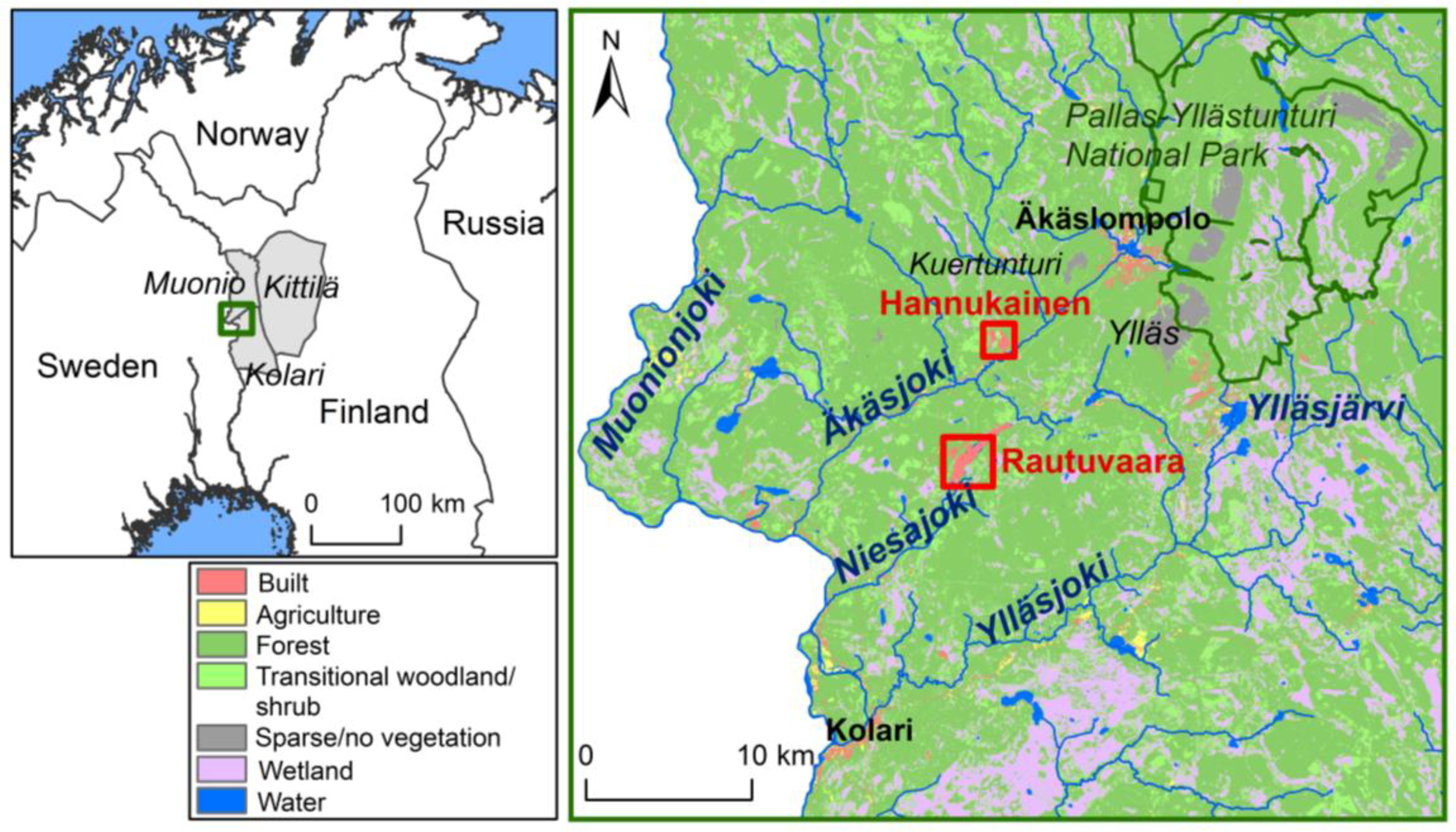
Modern metal mining in Finland dates back to the first part of the 20th century, and mines have been established particularly in northern and eastern parts of the country [
55]. These regions contain recently opened mines, planned mining projects, and a notable number of post-mining sites in a wide variety of physical and human environments. Despite the long mining history in Finland, post-mining landscapes have received relatively little scientific attention [
16]. To our knowledge, there have been no spatially explicit studies on the long-term impacts of mining on local land use or stakeholder values in post-mining landscapes in Finland or elsewhere.
We studied landscape values, knowledge needs, and land use preferences by local residents and visitors in two post-mining areas in northern Finland, Hannukainen and Rautuvaara, using a PPGIS approach. The studied iron ore–copper mines were closed three decades ago, and the reopening of the mining sites has been planned in recent years. In this paper, we focus on the following questions: (1) What kind of opinions and perceptions do different stakeholders have on the post-mining areas? (2) What kind of positive and negative values (co)exist in the post-mining areas and the surrounding regions? (3) Does the post-mining landscape contain sites of specific environmental concern? (4) How would mine reopening impact the current land use from the different stakeholders’ perspectives?
4. Discussion
In northern Europe, numerous metal mines were started and closed during the past century, leaving behind a variety of little-studied post-mining areas [
16,
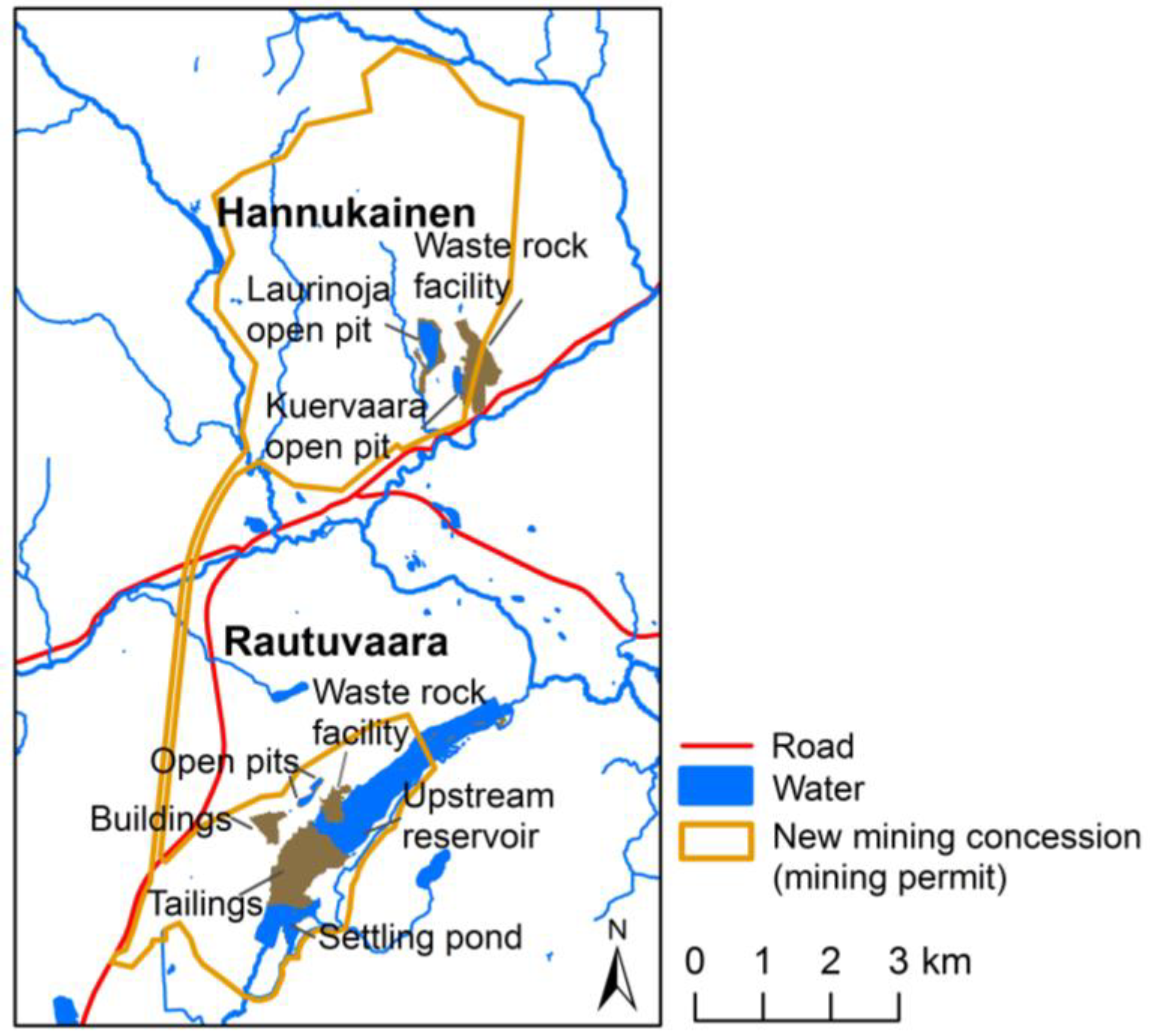
73]. Land disturbances together with possible soil, water, and air contamination can irreversibly change future land use potential of the mined areas. Our results from the Hannukainen and Rautuvaara post-mining areas demonstrate that the impacts of mining are not limited to the mining sites themselves or the operational phase of the mine. Rather, mining can also reduce the multifunctionality of the surrounding landscape, and the negative impacts on other land uses can continue long after the closure of the mine.
Globally, the levels of reclamation of post-mining sites range from abandoned “zombie” mines to carefully planned post-mining landscapes for a wide variety of purposes [
21,
23,
29,
32,
74,
75,
76,
77]. The closed Hannukainen and Rautuvaara mines belong to mining sites where no major reclamation and landscaping measures have taken place, resulting in a sharp contrast between the mined land and the surrounding forest landscape. It has been observed that mines closer to populated areas are under greater pressure from society to be adequately reclaimed compared to remote sites [
28]. In Finland, remote and/or small mining sites include a generally smaller number of new post-mining functions compared to significant mines located in the vicinity of population centers [
16].
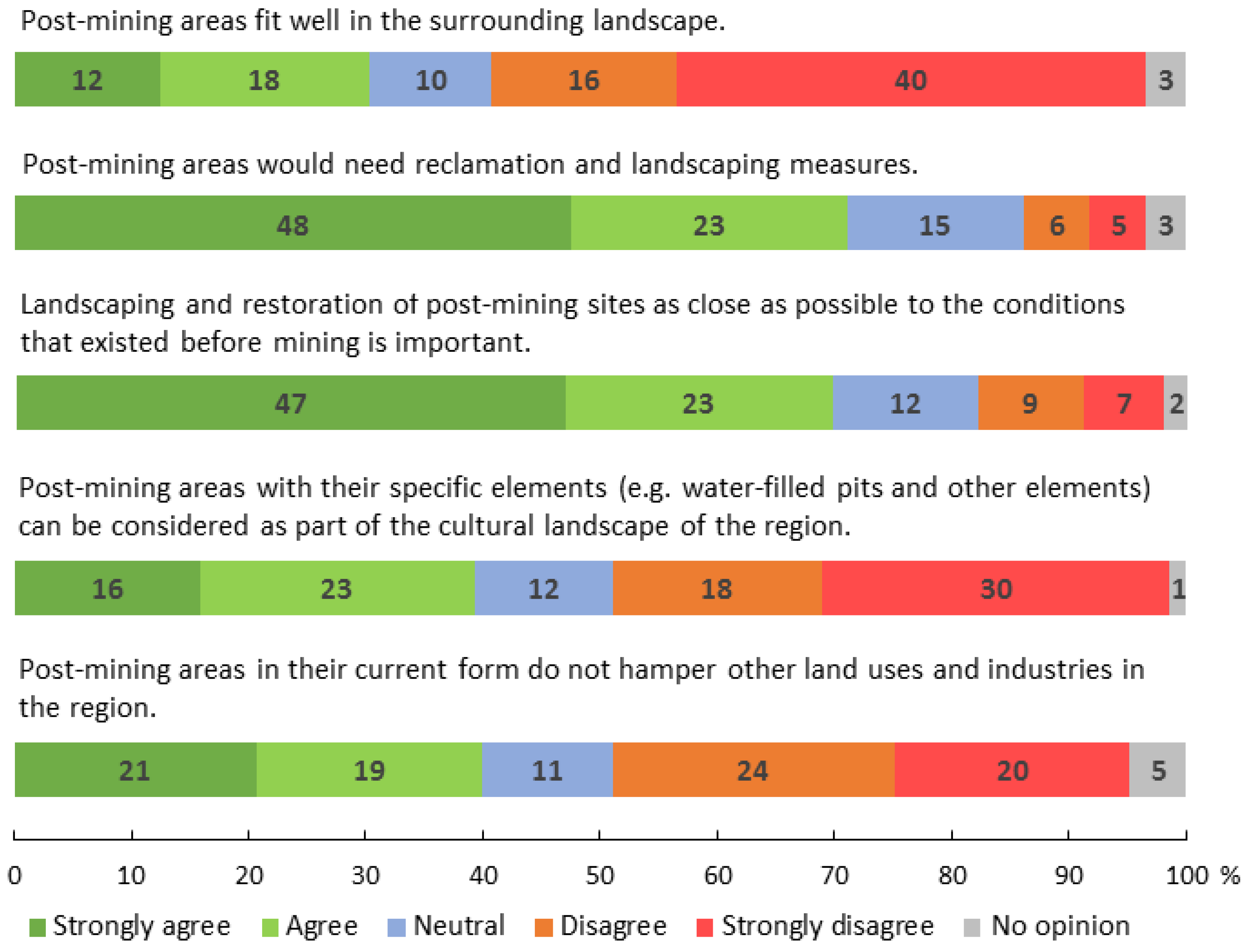
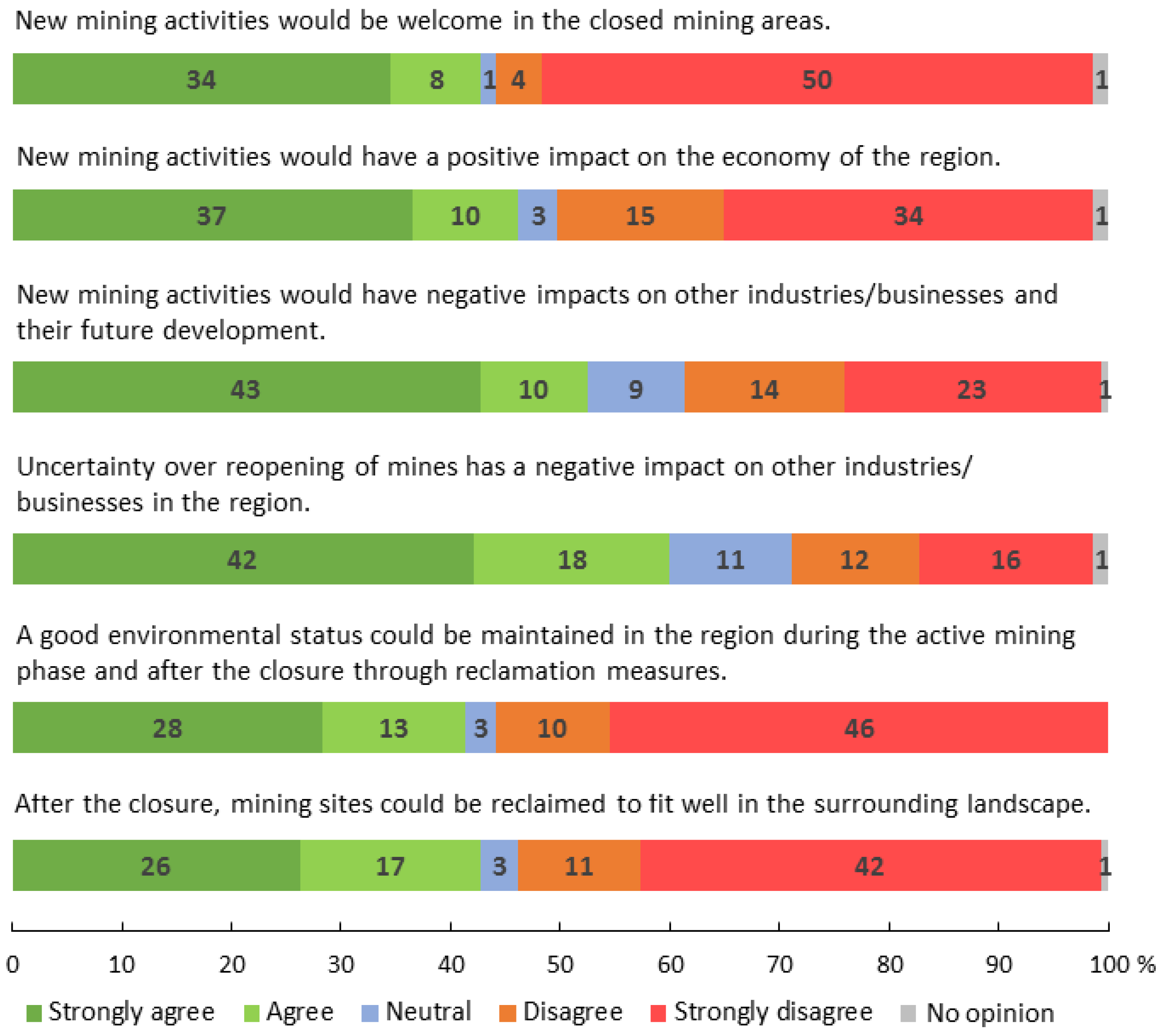
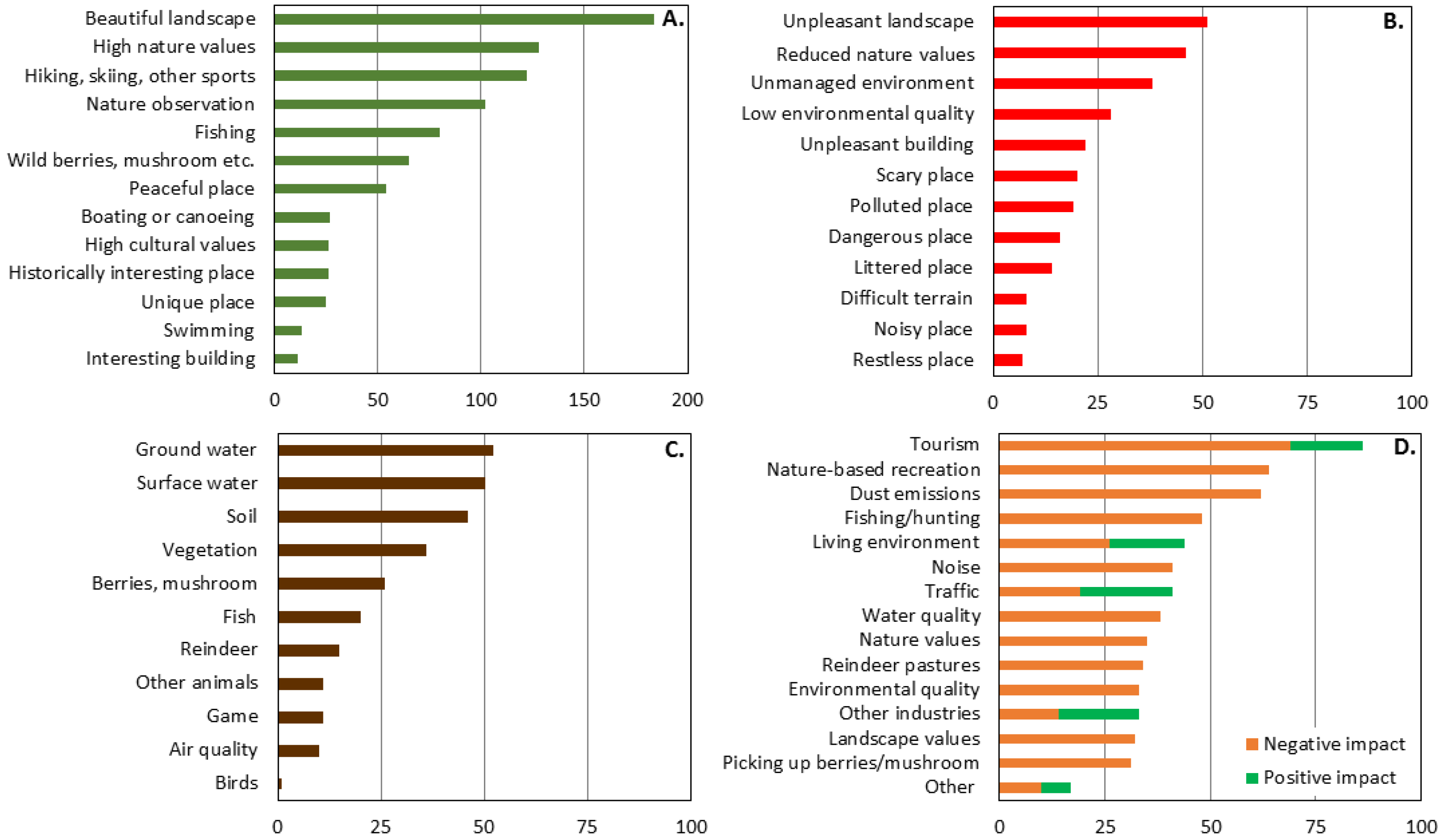
Our results show that a majority of respondents were dissatisfied with the post-closure management of mines. Waste rock, tailings, and other barren land were perceived as unpleasant places containing reduced nature value and low environmental quality. A majority of respondents were of the opinion that post-mining areas would need reclamation measures and that landscaping and restoration of sites as close as possible to the conditions that existed before would be important. The results show that positive opinions on post-mining areas were more common among respondents with a relationship to the mining industry and among local respondents living more than 20 km away from the mining sites. These groups were partially related, as local respondents living more than 20 km from the mining sites more often had a relationship to the mining industry compared to other respondent groups.
Although the perception of post-mining landscapes is often negative, some of them can hold cultural value reflecting past industrial history. This is particularly the case with mining areas that have had large mining communities and contain regionally or nationally valuable buildings and landscapes originating with historical mining activities [
16,
32,
78]. Some post-mining areas in Finland include mining heritage tourism, and some areas are utilized, e.g., for public (noncommercial) outdoor activities, such as birdwatching and scuba diving [
16]. In our survey, nearly half of the respondents disagreed, and around 40% agreed that the Hannukainen and Rautuvaara post-mining areas can be considered as part of the cultural landscape of the region. Post-mining land use at the sites was very limited. Only a few map markings indicated recreational activities or described closed mines as culturally or historically interesting places.
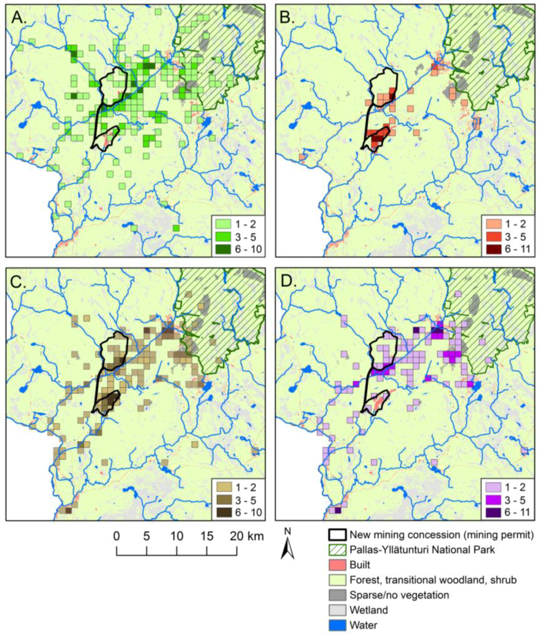
The results show that local stakeholders had various environmental concerns about the impacts of past mining activities on water quality, potential soil contamination, and the safety of natural products. While a majority of marked unpleasant places were concentrated in the post-mining sites, places where stakeholders wanted more information on the state of the environment were distributed over a considerably wider area in the landscape. Map markings related to environmental concerns and specific questions raised by respondents (
Table 7) highlight that, in addition to observed environmental changes, knowledge gaps and uncertainties on the state of the environment can impact local stakeholders’ everyday land use far outside the mining sites and long after the active mining period. National inventories of mining waste facilities in Finland show that the current environmental state of many post-mining areas is not well known. Although none of the closed metal mines included in the inventories present major accident hazards, reclamation needs should be assessed in more detail at many of the sites [
67,
79,
80].
The PPGIS survey shows that respondents had environmental concerns on water quality over relatively long distances from the post-mining sites. Globally, water contamination related to both active mining and historical mining legacies is a significant concern [
19,
81,
82,
83]. According to hydrological impact assessments in the study area, the water quality in most rivers is good. However, baseline water quality in River Niesajoki is negatively affected by former mining activities, and the quality improves with distance from the tailings in the Rautuvaara site [
63]. Historical tailings include harmful substances that can potentially dissolve in the water through oxidation [
66,
68]. So far, no significant amounts of harmful substances have been detected in ground water or in the riverine system. However, it has been recommended, for example, that an acidic pond between dams in the northern part of the Rautuvaara site should be fenced so that reindeer and other animals cannot drink acidic water containing heavy metals and uranium [
68]. Pit lakes in the Hannukainen and Rautuvaara sites contain elevated concentrations of various metals, and the water quality varies considerably according to the water depth [
63,
65].
Respondents were also unsure if it was safe to consume natural products collected in the vicinity of post-mining sites and for wild animals to graze/prey in the mined areas. In general, there is not much information available on soil contamination in post-mining areas and their surroundings in Finland. Separate studies carried out in connection with the environmental impact assessment of the Hannukainen mine showed, e.g., higher than baseline concentrations of many metals in humus and moss in the closed mining sites and their surroundings. Further, the concentration of cadmium exceeded the maximum allowed level in some mushroom samples collected in the vicinity of Hannukainen mine and roads [
65]. A recent inventory examined concentrations of heavy metals in natural products and water in mining environments in eastern Finland [
84]. The results of the inventory suggest that it would be important to know the baseline values resulting from the natural concentrations of metals in the soil and water compared to concentrations resulting from mining activities. In addition to increasing scientific knowledge on the environmental state of post-mining areas, it would also be crucial to distribute this information to local stakeholders.
Environmental accidents, human rights issues, and questions related to the share of benefits generated by mining have contributed to growing public concern about the environmental and social sustainability of the mining industry [
9,
85], and opposition to mining at the community level has increased during the 21st century [
86,
87,
88]. In the case of the new Hannukainen mining project, opinions on reopening the closed mining sites were notably polarized between respondents (see also Reference [
11]). As in the case of opinions on post-mining landscapes, positive opinions on mine reopening were more common among respondents with a relationship to the mining industry and among local respondents living more than 20 km from the mining sites. The most important positive effects raised by respondents included year-round employment, better public services, and improved infrastructure in the region. The strongest resistance was found among those working in the tourism industry or using tourism services. Particularly, vacation home owners, as well as respondents who reported outdoor activities in nature, did not support mining activities in the area. In addition to the negative impacts of mining on the nature-based tourism industry, respondents also raised concerns about mining impacts on reindeer herding. Respondents had more positive attitudes toward new mining projects in Finland (49% positive, 34% negative) than in the Hannukainen/Rautuvaara region (42% positive, 54% negative), which may at least partly reflect the unique multiple landscape values of the natural environment and high attraction to the area by both local and visiting land users.
The strength of the PPGIS survey is that it can reveal the spatial dimensions of potentially conflict-causing issues [
8,
52]. In our study area, nearly 60% of the pleasant places were located in the area containing the new mining concession and a surrounding 5 km buffer zone. Furthermore, map markings showed that pleasant places and places where the impacts of mining would potentially be experienced widely overlapped (32% of the 1 km grid cells). This clearly and spatially explicitly demonstrates the concerns over loss of the diversity of landscape elements and functions that support both occupational and recreational land use.
Increasing sizes of mining projects and declining ore grades result in increasing amounts of waste rock, a larger volume of tailings, and more extensive disturbed areas [
35]. The Hannukainen and Rautuvaara post-mining sites are relatively small compared to many mining areas in northern Europe. New mining activities would leave behind notably larger areas of disturbed land cover compared to past mining. For example, current post-mining landscapes include pit lakes of 1–16 ha, whereas new post-mining areas would contain two water-filled open pits of 64 ha and 220 ha [
65]. The plan to pump the processed waste water into the River Tornionjoki-Muonionjoki on the border of Finland and Sweden extends the potential negative environmental impacts far away from the mining site. When assessing the potential environmental impacts, highly relevant issues to address are the cumulative impact of all ongoing and planned mining activities in the region and transboundary environmental impacts [
89,
90].
A general objective of mine closure is to ensure long-term physical, chemical, and biological stability of the site to minimize potential environmental and health risks. In Finland, the statutory requirements placed on mine closure derive from a set of various statutes governing
inter alia mining activity, environmental protection, and waste management. Some statutes are applied to all mining projects by default (for example, the Mining Act (621/2011) and the Environmental Protection Act (86/2000)), whereas others are applied to mining projects based on the scale, nature, and/or location of the activities. Thus, the applicable legislation and stipulations for mine closure can vary from project to project. Requirements regarding mine closure are stipulated on a legislative level and through various government-issued permits. In addition, mining activity is also regulated by guides and instructions given and published by various authorities, experts, and scientists [
91,
92,
93].
Nowadays, mining licensing and environmental permitting usually require closure management plans in the early phase of the project. A mine closure plan is typically updated regularly during the project, and revision of the financial sureties for mine closure may also be required [
91,
92,
93]. The current preliminary closure plan of the Hannukainen mining project seeks to mitigate the harmful environmental impacts and ensure security in the area after the closure. The plan includes, for example, recommended options for the closure of open pits, tailings, waste rock, and infrastructure, and landscaping measures, but does not contain detailed information on future land use options in the post-mining sites [
94]. According to the plan, post-mining land use will be decided among stakeholders during the production phase. Our results show that over half of the respondents disagreed that a good environmental status could be maintained in the region during the active mining phase and after closure. Similarly, over half of the respondents disagreed that mining sites could be reclaimed to fit well in the surrounding landscape. Incomplete reclamation measures and lack of landscaping of former mining activities may contribute to shaping opinions on the success of future reclamation measures in the area.
A need for corporate social responsibility and social impact assessment has strengthened during the past years. The term “social license to operate” (SLO) describes a way of conceptualizing a corporation’s relationship with society and local communities. In the case of the mining industry, it has been interpreted as the social acceptance granted by a community for mineral exploration and mining activities [
95,
96,
97,
98,
99,
100]. In practice, the levels of approval or acceptance can vary over time. A mining company rarely has either total or zero approval or acceptance, as it is also unlikely that either all stakeholders or no one would approve mining activities. Furthermore, stakeholders may accept some aspects of a mining project and not accept others [
95]. The research of Reference [
3] highlights the importance of transparency in mining operations and the continuity of communication with local stakeholders in building and maintaining the social license to mine. Recently, the concept of social license to close has emerged from the need for a more holistic view of the impacts of mine closure on stakeholders. Better closure planning would help local communities adapt to closure, sustain future socioeconomic well-being, and promote beneficial reuse of project assets [
101].
In addition to perceived environmental impacts, mining conflicts and resistance also arise from the lack of representation and participation of local communities [
7,
102]. Public involvement in land use and natural resource planning has been rapidly increasing in recent years. The development of new geospatial information technologies, such as web-based PPGIS, provides new opportunities to open up land planning processes to citizens. PPGIS can integrate, organize, and present huge amounts of geospatial information, and remove place and time restrictions, which hinder stakeholders’ opportunities for public involvement. PPGIS captures local knowledge, helps to identify sensitive issues and locations, increases the exchange of information, opinions, and perspectives, and democratizes the planning process [
103,
104,
105]. The results of our study suggest that integrating detailed place-based data provided by different stakeholders as part of the planning process could support better land management in mining areas. PPGIS could also provide a useful tool for more sustainable land use planning in other kinds of northern environments that experience rapid land cover transformations arising from different land use pressures [
36,
106,
107].
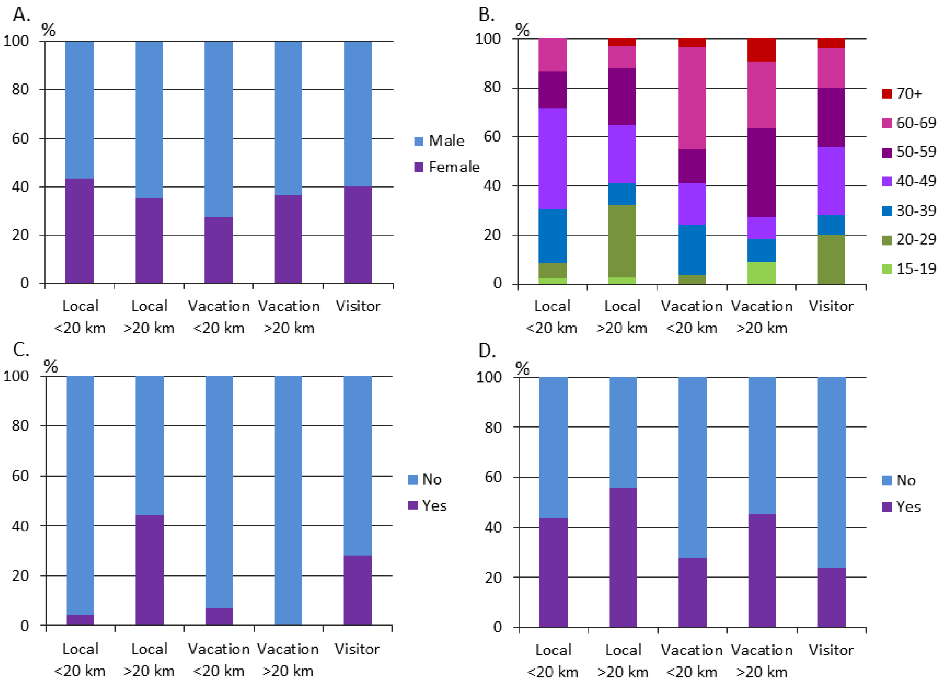
However, PPGIS approaches include many challenges to be taken into account. A web-based PPGIS survey can offer the possibility to influence individuals or social groups usually excluded from formal decision-making by governments and local authorities, but it can also exclude people who are not familiar with computers and map applications [
51,
105]. It has also been found that PPGIS yields the highest responses from people whose livelihood or other interests are closely related to topics of the survey [
108,
109], and that participants tend to be disproportionately male, older, and have higher levels of education and income [
110]. In our survey, there was a bias toward male participants as well as middle-aged participants. There were also relatively few younger respondents, which highlights the importance of better advertising of PPGIS surveys to younger citizens. Web-based PPGIS surveys combined with other means of participation are likely to produce the best outcomes in land use planning processes [
51].


