1. Introduction
The article begins with two important premises derived from the work of Yim and Luna [
1], who have asserted that (i) “the meta-industrial city reflects on how production in the 21st century is changing the way that cities are evolving from a consumption-based society, circling back to a deeper relationship between consumer and producer within the Fourth Industrial Revolution” (p. 7), and that (ii) “[a] twenty first century architectural and urban model that re-establishes industry as a holistic urban catalyst beyond just the economic dimension but re-integrating industry as an intrinsic part of the built form of contemporary human settlement” (p. 13).
In the U.S. Sunbelt, there is pressure to convert centrally located industrial land to non-productive commercial and residential uses [
2]. However, traditionally in the United States, more attention has been given to the planning and design of land for consumption purposes (e.g., shopping malls, big box stores, autoplexes, and hotels, as has occurred in both Phoenix, Arizona, and Orange County, California) than to the preservation of industrial land needed for production purposes. The main research question guiding this article is “What will it take to improve this situation, and has this even been attempted before?”
The redevelopment of industrially zoned land usually involves land assembly and the replacement of urban industrial land with other uses, such as business centers or warehouses. Some of the most recent research on urban industrial planning has dealt with purposefully designed eco-industrial parks, science and technology parks, and high-tech developments involving the incubation of R&D enterprises [
1,
3,
4,
5]. With the exception of Chappel’s research on industrial land in the San Francisco’s Bay area [
6], González et al.’s study on the relevance of a Geographic Information System (GIS) for the management and promotion of industrial development in the Spanish Basque Country [
7], Hawken and Hoon Han’s account of 3D mapping of the industry mix in downtown Sydney [
8], and Williamson and Dunham-Jones research on suburban retrofitting of office parks and corporate campus for job creation [
9], the researcher discovered an insufficient level of research on industrial land conversion and its timely preservation. Therefore, this article attempts to fill a gap in the scholarship of industrial development and industrial land retrofit in the U.S. Sunbelt.
Specifically, the article analyzes an attempt to help retrofit an old urban district in South Phoenix, Arizona, an area just south of the Phoenix Sky Harbor International Airport. It focuses specifically on the pressure to convert the remaining, centrally located, industrial land to non-productive commercial and office uses. It documents how a town-gown Advanced Urban Planning Studio (AUPS) at Arizona State University (ASU) produced an inventory and retrofitting strategy for the Wedge South Mountain industrial district. It is argued that the urban industrial district presents advantages to the local community in terms of urban structure, proximity to labor pools, highways, and the airport, and easy access to and from surrounding residential neighborhoods in the core of the Phoenix metropolis [
10]. The methods comprised an Advanced Urban Planning Studio, multiple inventories and site visits, presentations, and feedback from guest speakers and economic development specialists at the City of Phoenix and at the Greater Phoenix Economic Council (GPEC), as well as recurrent site visits by the instructor of record in 2015 and 2021. The key finding is a series of implications for the retrofitting of other urban industrial areas in the U.S. Sunbelt.
2. Analytical Framework
The purpose of the analytical mechanism is to systematically scaffold the research problem’s main dimensions by providing the necessary background to empirically analyze and test the case study’s most important variables later in the article. The industry’s main goal is to produce goods. Although industrial processes have evolved over time [
3,
11], at their fundamental level, industrial processes have remained similar with inputs, transformative processes, and outputs. The twenty-first century’s advanced industrial processes have evolved according to the latest technological changes [
5,
12,
13]. Higher levels of efficiency have required the reintegration of negative externalities in the circular economy through reuse and recycling [
14]. The growing motorization of the United States and the country’s high dependence on off-shore production, increasing reliance on freight containerization and the trucking industry, and airplane transportation have all changed the industrial process from a Fordist-oriented model to a post-Fordist production and consumption model, as is exemplified by the high number of warehouses in central Phoenix along the I-10 freeway throughout the Phoenix West Valley [
15,
16]. A situation that is starting to change is the fact that the vast numbers of warehouses found throughout the large Southwest metropolises of Phoenix and Los Angeles [
16,
17,
18] reflect the need for temporary storage places for products and goods manufactured abroad on their way to consumers.
Table 1 shows the dimensions of the analytical mechanism conceptualized in this section.
Industrial development in the United States can be traced back to the Northeastern states of Massachusetts, Rhode Island, Connecticut, and New York [
19]. Proximity to water bodies enabled industrial development to flourish in the Merrimack River valley, the Blackstone River valley, and the Connecticut River valley. One hundred and fifty years ago, the Western Massachusetts gateway cities of Chicopee and Holyoke were industrial bastions of textiles and paper production. In Eastern Massachusetts, the Lowell industrial complex (now Heritage State Park) was built to capitalize on technological innovations of that era and to export manufactured goods to other parts of the U.S. and abroad [
20].
Many of New York City’s boroughs, especially those situated by the Hudson River, such as Brooklyn and Queens, had a high concentration of manufacturing enterprises, together with warehouses (e.g., Brooklyn Navy Yard) [
21]. New York City’s size and maritime ports enabled the easy delivery of both raw materials and finished goods [
5]. Baltimore, Maryland, and Bethlehem, Pennsylvania, are well-known examples of former steel production places. Although Pulman, Illinois, became known for its company town model, no other cities encapsulate the Fordist model associated with car manufacturing and the Marshallian industrial district concepts better than Detroit, Michigan [
22], and Chicago’s central manufacturing district [
23], respectively. A common legacy of the industrial revolution is the brownfield contamination of hundreds of industrial sites from decades prior [
24]. However, since industrialization only reached the U.S. Sunbelt at a much later stage, the most recent industry in this region’s cities tends to be a lot more advanced, clean, and efficient than in the Northeast and the Midwest; this refers to what Satyro et al. call Industry 4.0 [
25].
The rise in the U.S. Sunbelt, epitomized by Phoenix and Los Angeles, occurred much more recently [
26,
27]. In between, one finds the industrialization of the mid-Atlantic region with the Carolinas and some of the Midwest states, such as Ohio and Kansas, with the airplane industry, and the Deep South state of Tennessee with its car assembly plants [
28]. However, the spatial relocation from the Northeast to the Sunbelt brought with it a change in industrial district typology [
29,
30]. More recently, the world has witnessed the rise in eco-industrial developments side-by-side with innovation and high-tech districts and incubation parks, with little to no production of manufactured goods; instead, Silicon Valley R&D innovation is associated with new technologies of information, such as the Googleplex in Palo Alto, and the Apple headquarters in Cupertino, California [
31].
Post-industrial regeneration [
32] tends to be more prevalent in older industrial areas in Europe [
33,
34] and the U.S. Northeast, since that is where industry has been around the longest [
35]. Many of those industrial-era mill buildings still have sturdy structures with “good bones,” which can be put to other uses, with, for instance, factory mills being converted to loft buildings [
36]. However, more recent industrial areas in the Sunbelt lack such industrial-age structures. Industrial facilities tend to be made of concrete and reinforced steel in consonance with the modernistic architectural style, which precludes their easy reuse and rehab. Therefore, many industrial buildings have been demolished, and only a handful of others have been renovated. Later-age urban and suburban industrial areas present greater challenges due to their combination of scattered buildings interspersed with storage sheds, piled-up recycled metal, vehicle depots, container storage, construction materials, and parked heavy construction equipment, among others [
37,
38].
Nonetheless, Dunham-Jones and Williamson have been studying ways to retrofit suburban neighborhoods for more than fifteen years [
9]. They have examined not only residential areas, but also commercial and industrial districts, and have shown a range of urban design strategies capable of augmenting the urban quality of life for residents, workers, and shoppers. A commonly used and adequate retrofit intervention methodology tends to comprise three main phases: inventories, analyses, and retrofitting strategies. The inventories are of land uses, roads and streets, open spaces, utilities, the integrity of the built environment and its architectonic structures, social services and programs, and opportunities to maximize the benefits of the circular economy. The analysis aims to examine the various characteristics of a district to understand its urban design possibilities. Traditionally, the retrofitted solutions make better use of the space, are more esthetically pleasing, and enable the retrofitted areas to become better integrated with their surroundings [
39].
The retrofit and regenerated urban industrial areas win in terms of energy savings, ecological solutions, and an overall lower environmental footprint [
25,
40,
41]. Successful industrial land retrofit and livelihood-enhancing economic development strategies go hand in hand. Workforce development, job creation, as well as paying for the upgrading and maintenance of the retrofitted areas is equally important to successful incubation and community economic development strategies [
41].
3. Methods and Materials
The research methods comprised a town-gown Advanced Urban Planning Studio at Arizona State University, multiple inventories and site visits to the study area and other industrial districts throughout the Phoenix metropolitan area, presentations and feedback from guest speakers and economic development specialists at the City of Phoenix and at GPEC, who also provided external validation. Recurrent site visits took place in 2015 and 2021. The planning exercise aimed to find retrofitting strategies capable of halting the conversion of industrially zoned land to other uses while encouraging the redevelopment of a more modern pollution-free eco-industrial park typology.
The industrial district (a.k.a. site) selected for the urban planning study took into consideration the following criteria: the area had to be within a reasonable driving distance from the ASU, Tempe campus, so that fieldwork and regular visits could be made to the district and it could be studied and designed according to the three C’s framework of compactness, connectedness, and completeness [
42]. The Advanced Urban Planning Studio relied on a design methodology with these standard steps: the identification of main issues, inventories of site characteristics, socio-economic activities, quality and integrity of the built environment, road infrastructure and public space, accessibility and transport, as well as economic activities and governance structures. The specific tasks are likely to be familiar to most urban planners when they attempt to improve industrial communities through the meager means available to them. In practice, this requires planners to do many different tasks and activities during the making and implementation of economic and urban design plans (e.g., the analysis of firms according to the Standard Industrial Classification (SIC); the synthesis of findings according to Commercial Real Estate Development Association (NAIOP) and Urban Land Institute (ULI) standards and best practices [
43]; the review of previous high-technology and advanced manufacturing studies, industrial zoning and warehousing regulations and plans; windshield and ground reconnaissance inventories and surveys; meetings with planners and business owners; report writing; the production of graphics; and stakeholders’ involvement in public participation processes).
Data were collected on land use, zoning, transportation infrastructure and modes, jobs, commercial and industrial activities, building and storage structures, workforce development programs, digital surveillance systems, and neighborhood governance. Most data were collected by the students; however, the interpretations, inferences, findings, and recommendations were synthesized by the author
a posteriori. The data collection procedures were those typical of a design methodology. We ensured that data collection was done according to the “completeness” criterion of the three C’s framework identified above [
42].
This study’s ethos reflects the broad genre of “public scholarship”—knowledge and scholarship deployed in ways that can ameliorate the virulence of wicked problems in the real world [
44]. It also builds upon calls for additional research on more conspicuous production by valuing the visibility of industry in urban re-industrialization processes [
45] and on fostering a small-scale artisanal economy [
46]. On the one hand, the notions that making production more conspicuous means interlacing manufacturing back into the fabric of the city, creating added visibility and proximity to productive spaces in ways that bring forth opportunities for greater interaction and civic vibrancy were amply corroborated [
45]. And on the other hand, Kapp’s argument that “artisan-based economy, which values highly crafted specialized goods and blends old manufacturing techniques with new digital technologies” [
46] (p. 477), helping to regenerate American post-industrial urban districts, was endorsed. In this vein, Wolf-Powers et al. identified three distinct types of maker enterprises: micro-makers, global innovators, and emerging place-based manufacturers, of which those belonging to the last group appear to have “the highest potential for employment creation, both directly and via the business growth they stimulate” [
47] (p. 365).
It is important to disclaim that the case study analysis was impacted by the Global Financial Crisis (GFC) [
48], and that its findings are now even more relevant in the context of a growing interest in helping to create higher visibility for the regeneration of American post-industrial urban districts, as Mack and Mayer demonstrated in their study of the evolutionary profile of Phoenix’s entrepreneurial ecosystem (EE) [
49]. It is also opportune to disclose that expert opinions were acknowledged verbally by the instructor and the teaching assistant during guest talks and the students’ mid- and end-of-semester presentations. Students were encouraged to add those external validations to their Urban Planning Studio written report.
Table 2 synthesizes the Advanced Urban Planning Studio’s main characteristics as well as the study area’s main challenges and policy recommendations.
4. Case Study: Phoenix, Arizona
With a population of 1.6 million people, Phoenix is not known as an industrial city. However, this number of more than 4 million people has grown exponentially after World War II, mostly due to its central location in the state of Arizona, mild weather for most of the year, flat topography, plentiful flows of labor force, and a high number of “winter bird” migrants in search of a retirement oasis in the attractive Sonoran Desert. The City of Phoenix developed on the north bank of the Salt River. The river provided water to irrigate the farms while separating the city into two halves. While the city grew both eastward and westward out of Central Avenue, the river’s physical barrier effect created a north–south separation with the more highly praised residential areas located to the north and the lower-income residential and industrial areas located to the south.
Before WWII, industry was in the central area of the city, by the main freight train tracks in South Phoenix, by the riverbanks, and near Sky Harbor International Airport [
51]. The growth out to the inner suburbs occurred both eastward and westward, with some technology-oriented plants located near Papago Park in the East Valley, both in Phoenix and Scottsdale (e.g., Motorola) and in South Tempe [
52]. Most of the city’s warehouses are located outside of the city center along the I-10 Freeway corridor, mostly in the West Valley (e.g., Phoenix and Tolleson) and along the Grand Ave corridor (e.g., Phoenix and Glendale). The latest generation of industrial development, such as Intel chip manufacturing plants, has occurred in the southeastern corner of the metropolis in the suburban municipality of Chandler [
16,
53].
Centrally located light industry districts can still be found within several county islands, which are not conditioned by the City of Phoenix’s zoning proclivities [
54]. These administrative islands are, nonetheless, dependent on adjacent cities for public services. Despite having received several EPA brownfield remediation grants, the City of Phoenix still possesses several brownfield sites near the Salt River. The Sky Harbor International Airport is a major economic generator, and Kasarda and Lindsay’s “Aerotropolis” model [
55] can be loosely utilized to understand its impacts in the core of the metropolis.
Examples of centrally located post-industrial high-tech developments can also be found in downtown Phoenix with the Translational Genomics Research Institute (TGEN) and a small cluster in South Scottsdale at ASU’s Sky Song campus [
56,
57], with a similar counterpart in Tucson [
58]. An important attempt at creating intermunicipal collaborations for economic development in the core of the metropolis took place in 2006 with the proposal of an “Opportunity Corridor” throughout central Phoenix, which several years later grew into a three-municipality economic development arrangement called the “Discovery Triangle” [
59].
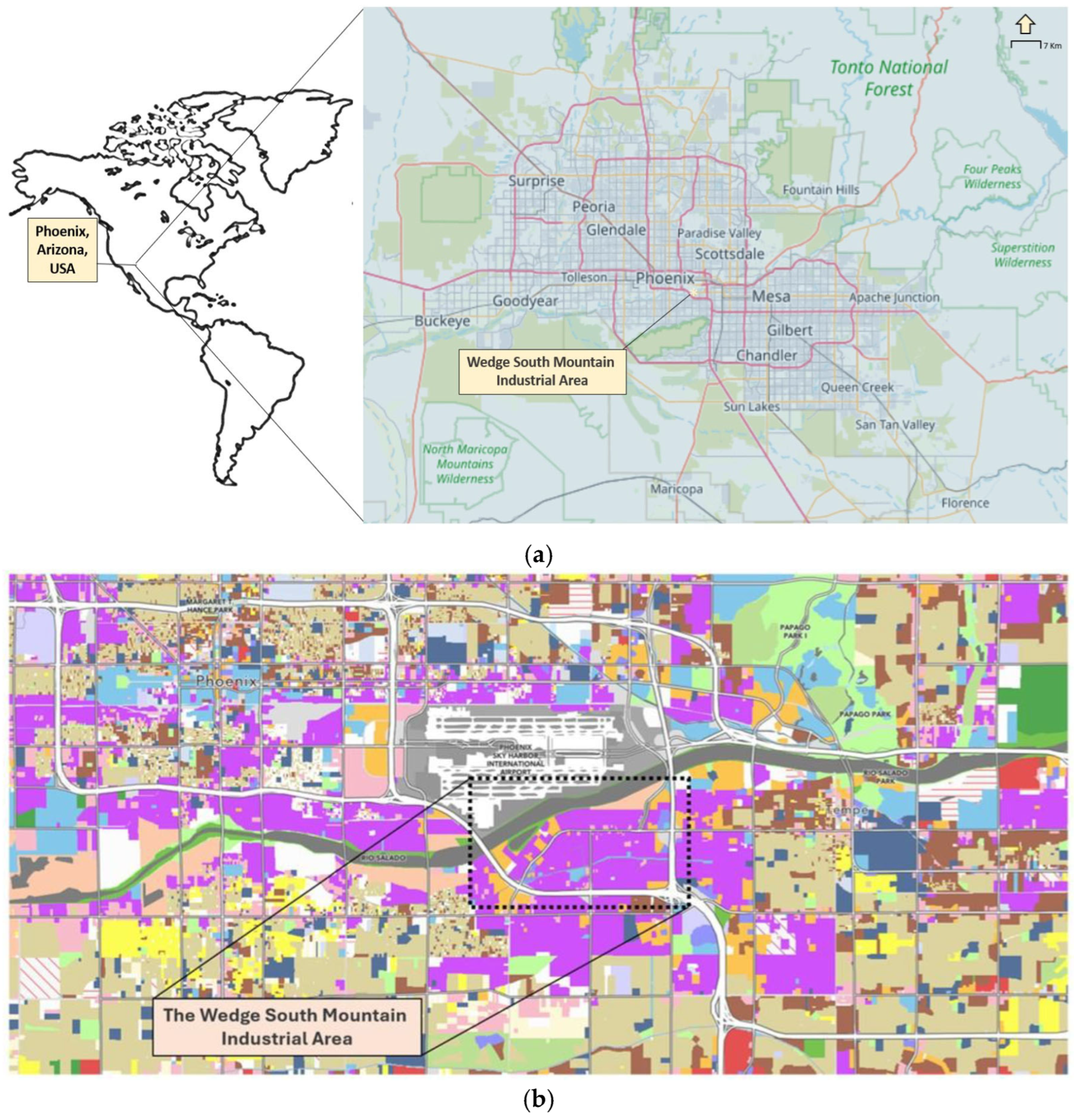
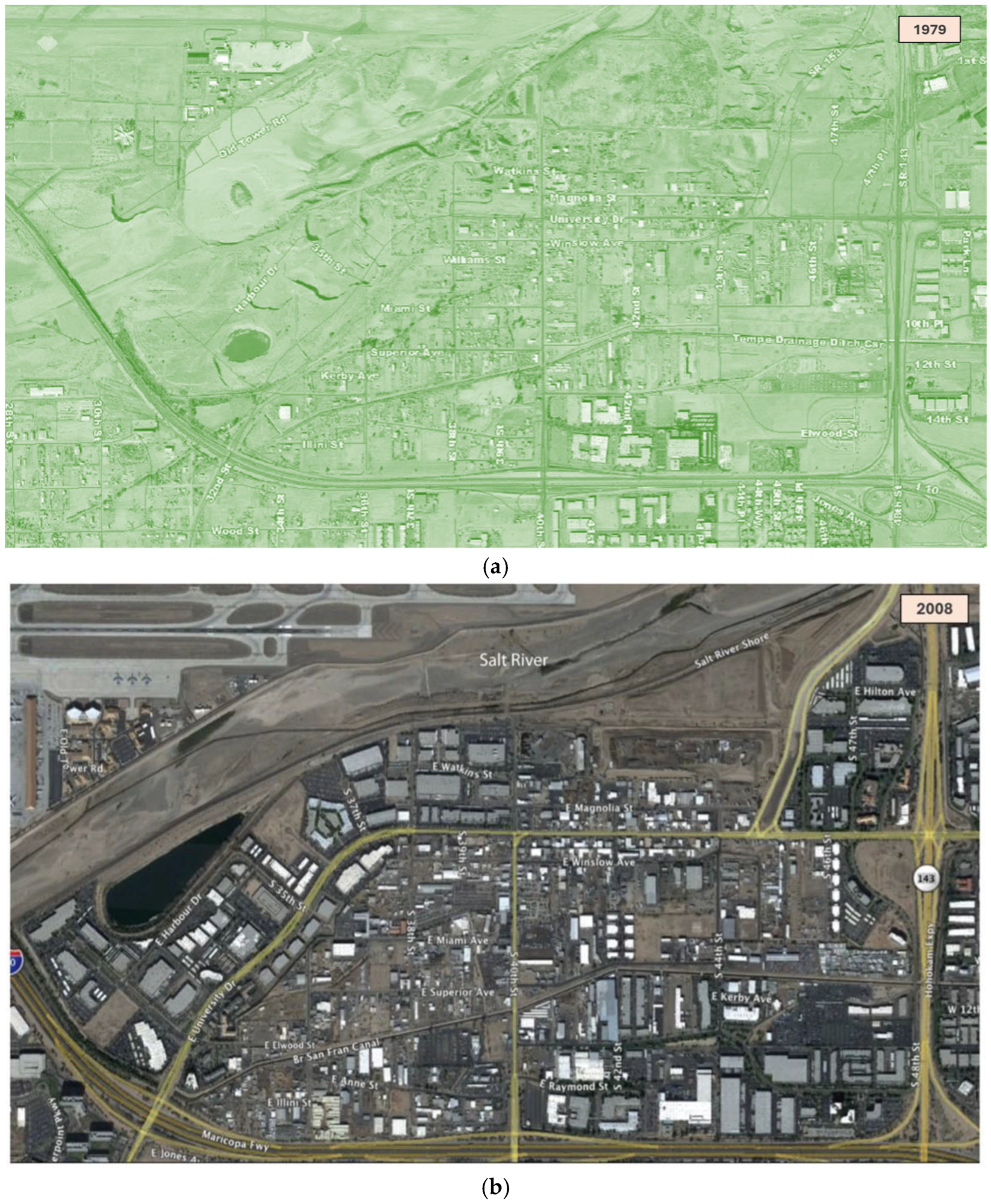
The Wedge Industrial district is located on the south bank of the Salt River, just across from Sky Harbor International Airport (
Figure 1a,b). In its heyday, it was the farthest away area from downtown Phoenix, while being adjacent to the northwest corner of the Tempe municipal border. Given its peripheral location in the city, it was considered an ideal location for a solid waste landfill. It is important to recognize that in the early 1900s, the area was already an autonomous African American community, known as Okemah, which had been settled by migrant workers from Oklahoma and Texas.
The South Mountain industrial district has been transformed from its early beginnings of farm-work-related livelihoods to an area punctuated by a landfill, warehouses, small businesses, adult entertainment venues, light industry, salvage yards, and construction materials depots. The area now comprises some light industry, and is home to various construction companies with storage space for construction equipment and materials, recyclables, etc.
Figure 2 shows the evolution of the Wedge South Mountain industrial district at two distinct moments in time: 1979 and 2008. Until recently, the City of Phoenix also had its sanitation department and truck depot located in the district.
The construction of the I-10 highway in the early 1970s bisected the South Phoenix neighborhood, and, years later, the Hohokam Expressway bypass (SR 143) was built to facilitate access to the nearby international airport and to ease congestion on the main highway. These roadway improvements induced major land use changes in the South Mountain industrial district, such as the construction of two new University of Phoenix campuses, several warehouses, business parks, and hotels.
Before these south–north roadway connections, the east–west arterial road, University Drive, was the dominant thoroughfare through the industrial district. To the west, there was substandard affordable housing, and to the east, there is one of Tempe’s industrial areas, which is highly dependent on airport business. As mentioned above, industrial and business parks abound throughout the Phoenix metro area. While business parks can be found adjacent to highways and main arterials (e.g., Black Canyon Freeway, I-17) and inside Planning Villages (e.g., Maryvale business park on 51st Ave), outside of the Sky Harbor International Airport’s “aerotropolis cluster”, industrial parks are quite dependent on their proximity to the roadway network.
The largest cluster of industrial facilities is in West Phoenix and, hidden in plain sight to the south and west of the Capitol Mall district, in and around the I-17 Loop through downtown Phoenix. The downtown warehouse district in South Phoenix has been slowly converted to leisure and recreational uses with ballparks, a new county courthouse, the Icehouse Art Gallery, and other event spaces. Furthermore, an old pre-WWII affordable housing development, known as Matthew Henson, was demolished and rebuilt by HUD’s Hope VI program as a mixed-income residential complex with amenities.
The district is characterized by industrial land uses, a landfill, and a small percentage of vacant land. There are several commercial establishments such as hotels, restaurants, fast food outlets, nightclubs, gentlemen’s clubs, and gas stations. Vacant land is utilized to store construction equipment. The roadway system consists of a hierarchy of roads and streets with pavements in different conditions. The higher caliber arterial roads experience regular through traffic. The district also has an open-air water canal. The movement of heavy construction machinery is a regular sight in the area. The built environment is newer and located near arterial roads where sites tend to have larger footprint buildings, such as warehouses, university campuses, hotels, and office buildings. Those buildings are also better conserved than many of the office, construction, and storage buildings.
A common feature of the built environment is the presence of property walls, fences, and surveillance systems. In terms of economic development, the area employed approximately 22,000 people just before the GFC, with the highest concentration being in manufacturing (22 percent), construction (17 percent), and wholesale trade (16 percent) [
60]. Some of the governance and regulatory mechanisms in place throughout the district are the Phoenix General Plan (PGP) and the city’s zoning code (PZC). To enable transport-led land changes, several major rezoning applications were filed during the 1990s to change zoning categories from light industry to commercial and other tertiary services.
5. Discussion of the Planning Proposals
Table 3 shows some of the case study’s indicators considered in the inventories and the main planning proposals recommended to the stakeholders. The topics parallel the thematic groups created by the instructor of record at the beginning of the semester, while the indicators evolved organically as the studio research process progressed towards the final presentation and deliverable. Industrial and commercial properties get transected in the marketplace similarly to housing developments. Large parcels of land are purchased and owned by a developer who either subdivides them into small lots and sells them, or develops the land according to the anticipated uses of its future tenants [
63].
5.1. Land Use
Large self-run businesses and industrial parks are similar to Planned Unit Developments (PUDs) in that they often function with Homeowner Association (HOA) and are governed by Covenants, Conditions, and Restrictions (CC&R) regulations. The main goal of this management unit and normative codes is to protect the values of the whole development. However, smaller and especially older industrial areas usually do not have a central management unit in charge of planning and maintaining the area’s design integrity. The livelihoods of those who own those businesses (and their families) are at stake when radical land use transformations are envisioned [
64]. Augmenting the innate characteristics of those areas without imposing excessive burdens or displacing those who earn their living in those places ought to be a key priority when considering the retrofit of an urban industrial area.
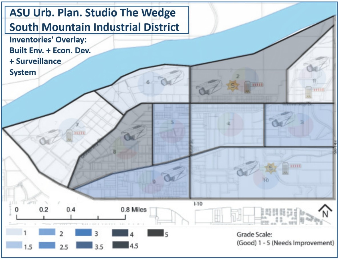
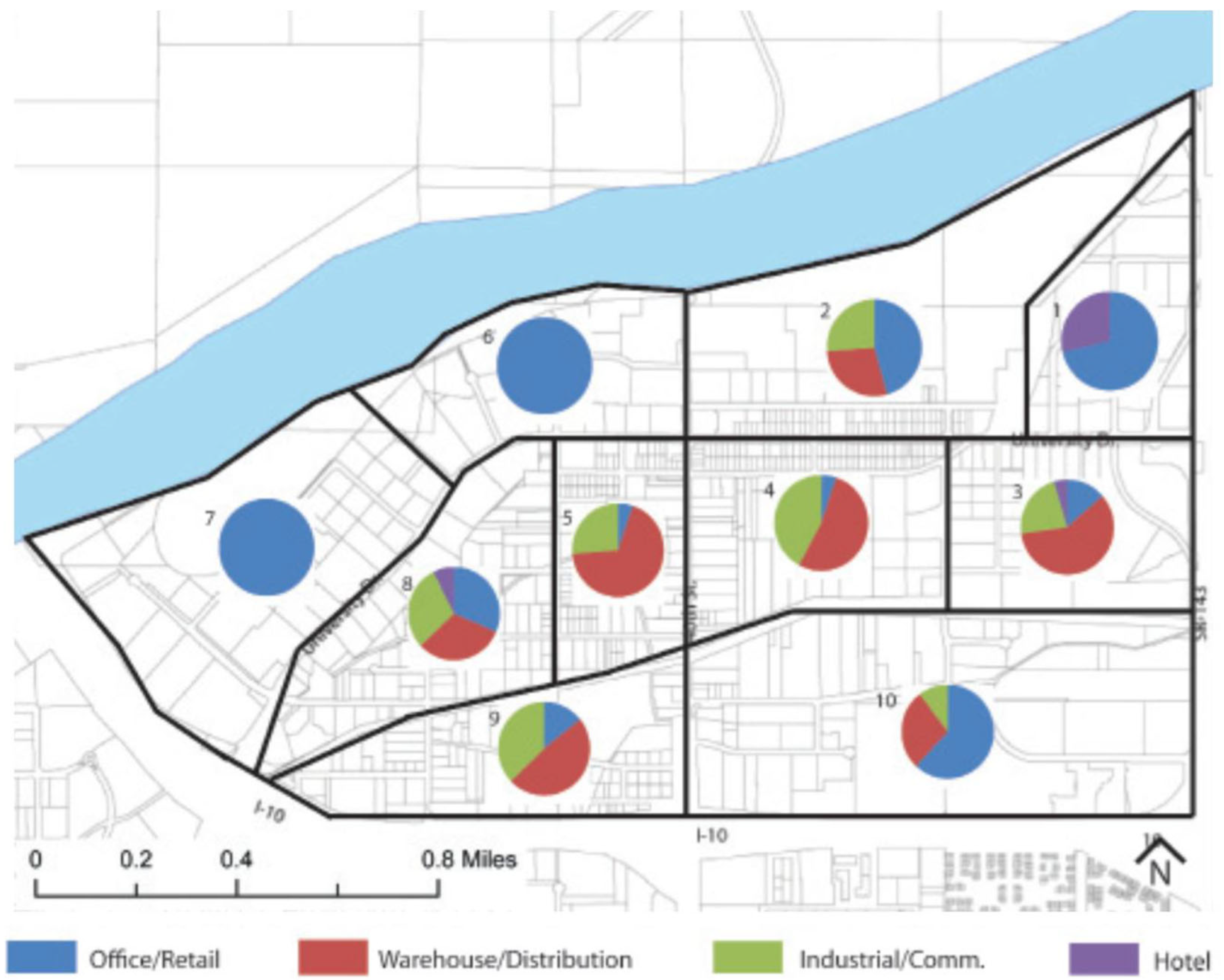
Figure 3 shows the land use categories present in the Wedge urban industrial district.
To a certain extent, the eco-industrial park model is easy to design and build. However, converting an existing area into an eco-industrial park (including the reuse of negative externalities such as effluents, energy, and solid waste in a circular fashion) requires complementary businesses and a coordinating entity to facilitate the reconversion. The integrity of the built environment, the structural safety of equipment and other goods, and the well-being of workers ought to also be guaranteed. Public authorities have a critical role in creating and helping maintain a healthy, safe, esthetically pleasing working environment for everybody. Fully functioning and properly maintained open spaces are also needed in industrial districts. They enable chance encounters, relaxation, and convivial interactions among patrons.
Land use finding: Zoning is the most popular land use planning tool; however, it is not necessarily the most enforced planning and urban design instrument in an industrial district. The location of the Wedge industrial district is very convenient due to its proximity to the international airport and the freeway system. That might have been one of the reasons for the coalition of stakeholders to be included it in the Discovery Triangle initiative.
5.2. Transportation
City administrations are usually busy attracting new businesses. The City of Phoenix planners had limited resources to prioritize investments in the many commercial and industrial areas scattered through locations adjacent to main highway corridors [
65]. Therefore, industrial land uses tend to appear haphazardly, comingled, often as if they had emerged spontaneously. In terms of transportation and utilities, cities tend to provide the bare minimum level of infrastructure (i.e., roads, water, high-voltage electricity, sewers, and broadband internet). Private businesses are responsible for paying for increases in higher-voltage energy. More accommodating
turn radii for trucks, large construction machinery, and emergency vehicles to turn at intersections ought to be arranged during industrial area retrofitting processes [
66]. Streetscape improvements increase the visibility of the industrial area and create a stronger image in the minds of those who work there, and especially in the minds of those who require services from the businesses located in the district. Some utilities can be buried to decrease their visual impact and to eliminate potential disruptions during productive processes or when operating heavy machinery.
Tactical urbanism can also be utilized for temporary, low-cost transportation improvement solutions, before more expensive improvements are built permanently. Industrial areas can benefit from deploying materials, designs, and fabrication know-how in urban design and public art improvements that increase (or soften) the rough working character of the district. Such design strategies can be utilized to increase the industrial and cultural legacy of the area and make it distinctly different from competing areas. Among the main issues to take into consideration during the retrofit designs are gateways, open spaces, sidewalks, intersections, greenways, and bicycle and walking trails.
Transportation finding: Firstly, there was little interest by the City of Phoenix planners in utilizing urban design streetscape improvements to enhance the character of the South Mountain industrial district, and (indirectly) to increase the district’s economic development potential. As the research progressed during the semester, a common interest in the betterment of the urban industrial district developed over time.
5.3. Built Environment
Given that distinct businesses perform different services and require different built-up structures, such as warehouses, storage sheds, garages, etc., all these different types of buildings must be permitted and licensed for their structural integrity; however, some of them may not conform to a specific site plan and do not incorporate the latest industrial design guidelines. The planning studio revealed that the built environment in industrial districts tends to be eclectic. Urban design guidelines for industrial zones, if they exist, tend to be flexible. Many structures were likely built way before any design guidelines or even zoning codes were enacted, and so many built-up structures were simply grandfathered in.
Moreover, the built environment is likely to comprise structures with different uses, functions, and setbacks, including headquarters offices open to the public, private quarters, production and manufacturing areas, small and/or quite large open-air built-up storage spaces, public and private parking areas, and protection devices, such as walls, fences, and other surveillance systems. Warehouse facilities require loading and unloading service bays. Depending on the type of fabrication process in place, buildings, raw and manufacturing materials may or may not be screened from public view by masonry fences or any other devices. By their very own nature, industrial districts possess a working environment, and it is the agglomeration effect via economic relationships with nearby firms that keep many of the businesses in the district [
67]. Complementary structures and uses, such as fast food, restaurants, and childcare facilities, will attract workers and enable the continuation of industrial and commercial uses in the district.
Built environment finding: It was discovered that many property owners had little interest in sprucing up the district-built environment and its visual character. However, no one opposed to having the City of Phoenix retrofit the district’s common public spaces.
5.4. Economic Development
In terms of economic development, a spruced-up industrial district signifies a vibrant local economy [
68], which experiences minimal business rotation and tends to function at capacity. A high number of vacancies is a sign of abandonment, disinterest, and poor performance overall. In older industrial areas, it is common to have businesses function without a centrally coordinating entity. In newer and more integrated industrial zones, the landlord and/or tenants usually have organized volunteers who lobby and market on behalf of the industrial district.
Figure 4 displays the breakdown of dominant economic uses in the district.
Economic development departments in large cities have many concerns and will have difficulty catering to the needs of all the industrial areas within their cities’ jurisdictions. Regular contacts between those in the industrial district being retrofitted and the city’s economic development specialists will ensure that new investment is directed to vacant spaces within their industrial district. Regular audits of services needed in the district and their prompt creation will enable businesses to expand in loco without having to relocate somewhere else. Compromises among businesses are needed in terms of energy, space, and number of workers, since their needs will vary over time.
Economic development finding: Contrary to other city districts, market forces tend to dictate what happens in an urban industrial area. To be effective, normative plans and other regulations will need more stringent monitoring and enforcement. Besides Tax Increment Financing schemes (TIFs), Business Improvement Districts (BIDs), Economic Development Overlay Districts (EDOD), and Industrial Protection Zones (IPZ) can also be implemented to plan and pay for improvements to common areas, including gateways into the district, landscaping, buffer areas, attraction and retention programs, and common promotional activities.
5.5. Human Factors
If industrial workers do not have advanced college degrees (master’s and bachelor’s), in most industrial professions, they are required to have certifications of competence (e.g., electric, plumbing, welding, air-conditioning, etc.). Zoning regulations that strictly separate industrial land use from residential areas usually impose a burden on workers who must travel, sometimes long distances, between their places of residence and the places where they work. On-the-job training and continuing education opportunities are provided by certain types of businesses but not by others. Workforce development collaborations between community colleges and universities can help prepare better-trained workers. Large corporations tend to be capable of offsetting training costs. However, smaller businesses may have difficulty providing such benefits.
Employment centers play a critical role in matching labor pools with available jobs. Businesses that provide in-kind services, such as health insurance, retirement contributions, and kindergartens, are cognizant of their workers’ rights and needs. Industries located near public transport routes traditionally do not have difficulties recruiting and maintaining skilled workers. An expeditious and effective workforce attraction strategy consists of maintaining open channels of communication between businesses in industrial districts and local and regional employment centers.
Workforce development finding: Effective collaborations between the business community and community colleges and universities are needed to match specific training needs. Regular continuing education opportunities will also help workers deal with any new challenges brought about by added competition or changes in production processes.
5.6. Governance and Regulations
An effective urban industrial district’s governance is critical to the maintenance of productive areas. The responsibility for the maintenance of the public right-of-way belongs to the municipal jurisdiction. On the one hand, adequate paving, streetlights, landscaping, and sidewalk maintenance, regular police patrolling, prompt emergency response services, and enforcement of noise and dust control within regulated levels are all public responsibilities. On the other hand, the promotion of the district, the assurance of safe operating standards, and the defraying of the collective improvements that benefit the whole urban industrial district are the responsibility of those who conduct business in the district.
City-wide (and/or sectoral) chambers of commerce and industry (e.g., Hispanic or African American) work with their constituencies (i.e., fee-paying members) on a regular basis. Typically, these organizations are responsible for creating networking opportunities for members (i.e., breakfast and brownbag speaker luncheons), editing their own bi-weekly newsletters and monthly magazines, and compiling databases of events, contacts, properties, and prospective business opportunities. Annual events such as dinner galas and golf tournaments are also common events promoted by chambers of commerce and industry.
Retrofitting strategies are also important moments to anticipate infrastructure needs and potential collaborations among business partners [
43]. Timely decisions are likely to entice future investors to an industrial district. The Phoenix Discovery Triangle initiative has shown how a private sector actor (in this case, a realtor) attempted to cash in on a redevelopment opportunity by joining forces with three municipalities. The creation of a common purpose GIS enabled the initiative to facilitate connections among most, if not all, stakeholders in the Discovery Triangle area of intervention.
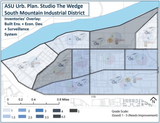
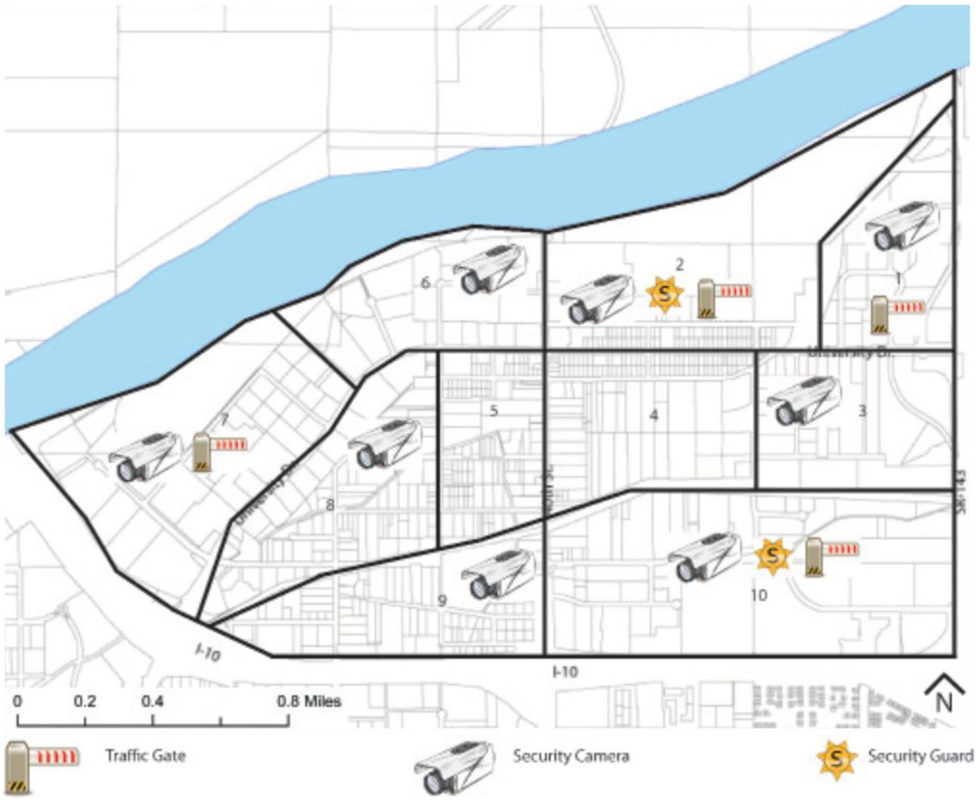
Figure 5 displays the dominant surveillance systems in the district [
69], while
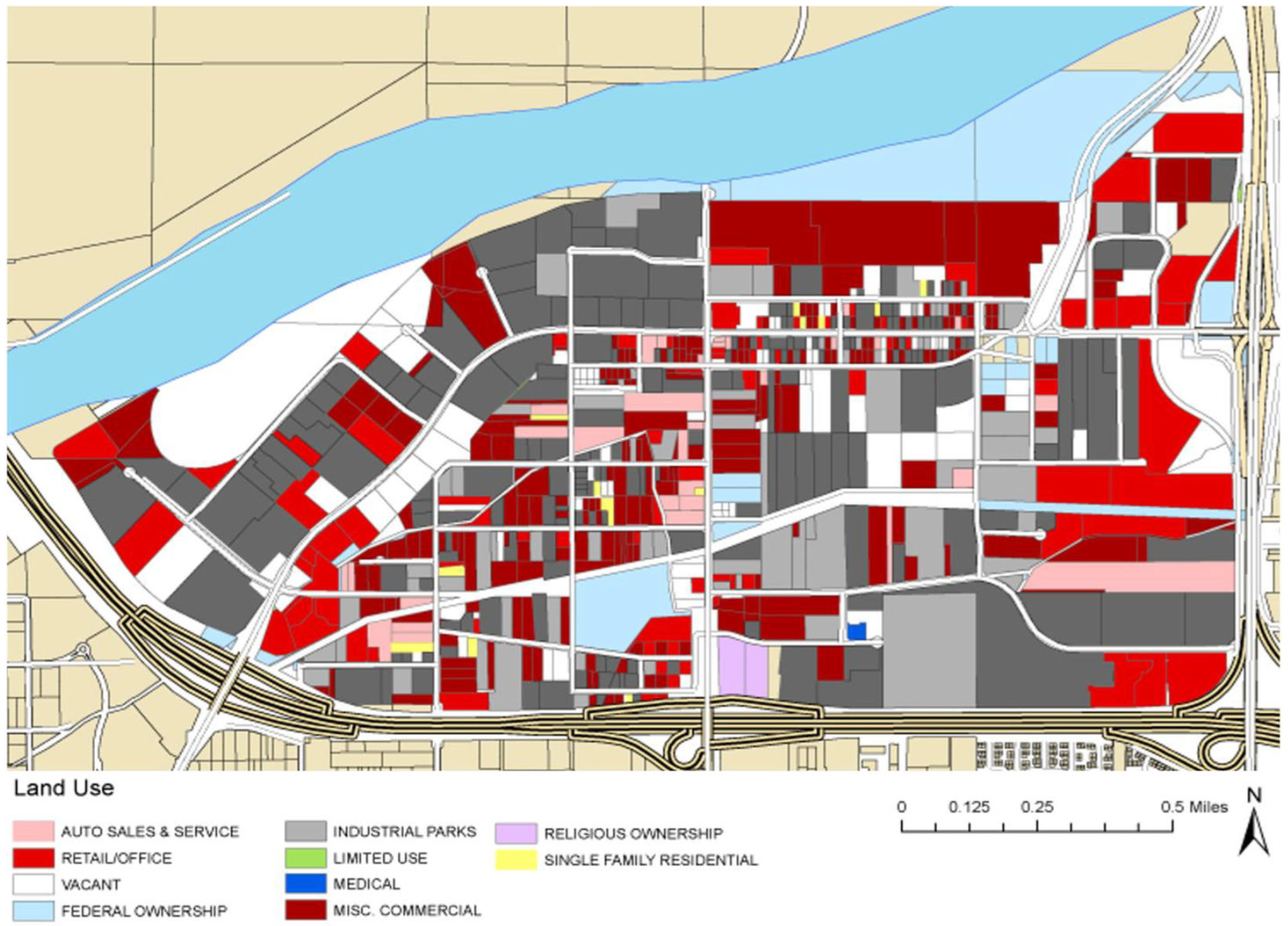
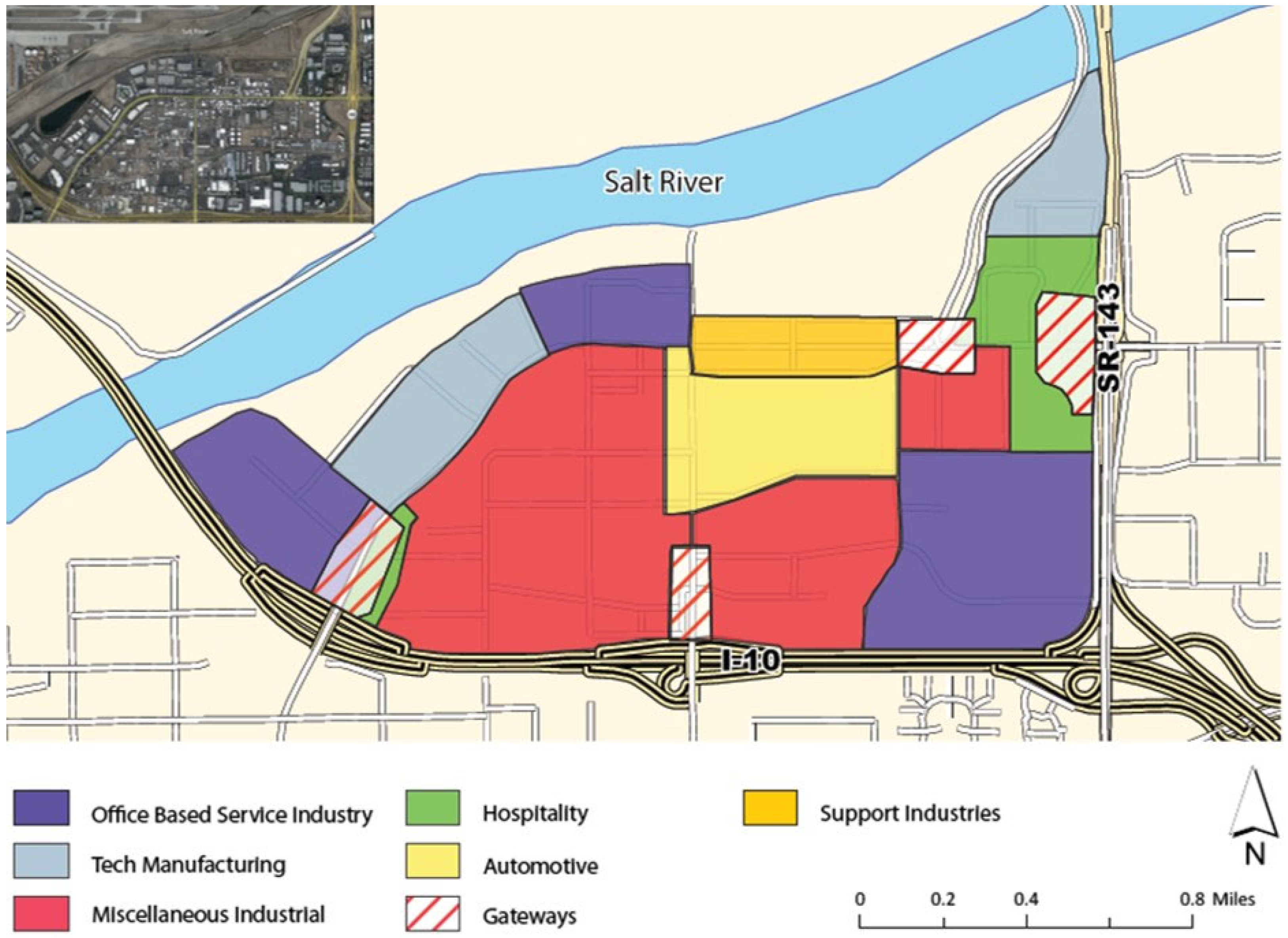
Figure 6 shows the proposed composite map of the district.
District’s governance finding: The study revealed that, apparently, no one was in charge of industrial districts. Most institutional actors, such as the City of Phoenix, GPEC, and the various chambers of commerce and industry, tended to have broad economic development goals, including attracting investment to the city. However, that was being done independently of where such development was most needed or was likely to flourish in the future. Tax revenues were collected city-wide, and by the same token, monthly or annual fees for memberships in chambers of commerce and other similar organizations were charged independently of where needs were most felt (or opportunities made the most sense). From a policy perspective, when locational priorities exist, the emphasis is on high-visibility areas, such as downtown or inner-ring suburbs [
50]; in the Phoenix case, that was along the Loop 202, and the East–West Washington Avenue and Van Buren Avenue corridors.
6. Conclusions
Industrially zoned land in the U.S. Sunbelt is being converted to non-industrial uses such as business centers, hotels, surface parking lots, and retail developments with mounting losses to the healthy entrepreneurial ecosystems [
2,
49]. This article has presented a discussion of an inventory and retrofitting strategy for an industrial district in Phoenix, Arizona. An industrial retrofit strategy ought to be proactive and aim to endow the industrial district with the conditions needed to modernize, increase the esthetics, and the safety of the district, while maintaining it more resilient to competition from other industrial areas elsewhere in the region [
70]. The research presented here resulted from a community-embedded town-gown collaboration. Other noteworthy collaborations have occurred elsewhere, including at Georgia Tech in Atlanta, Georgia, and at UC Berkeley in Berkeley, California [
6,
71,
72,
73].
One unique outcome of the specific collaboration was the constitution and deployment of the Discovery Triangle initiative [
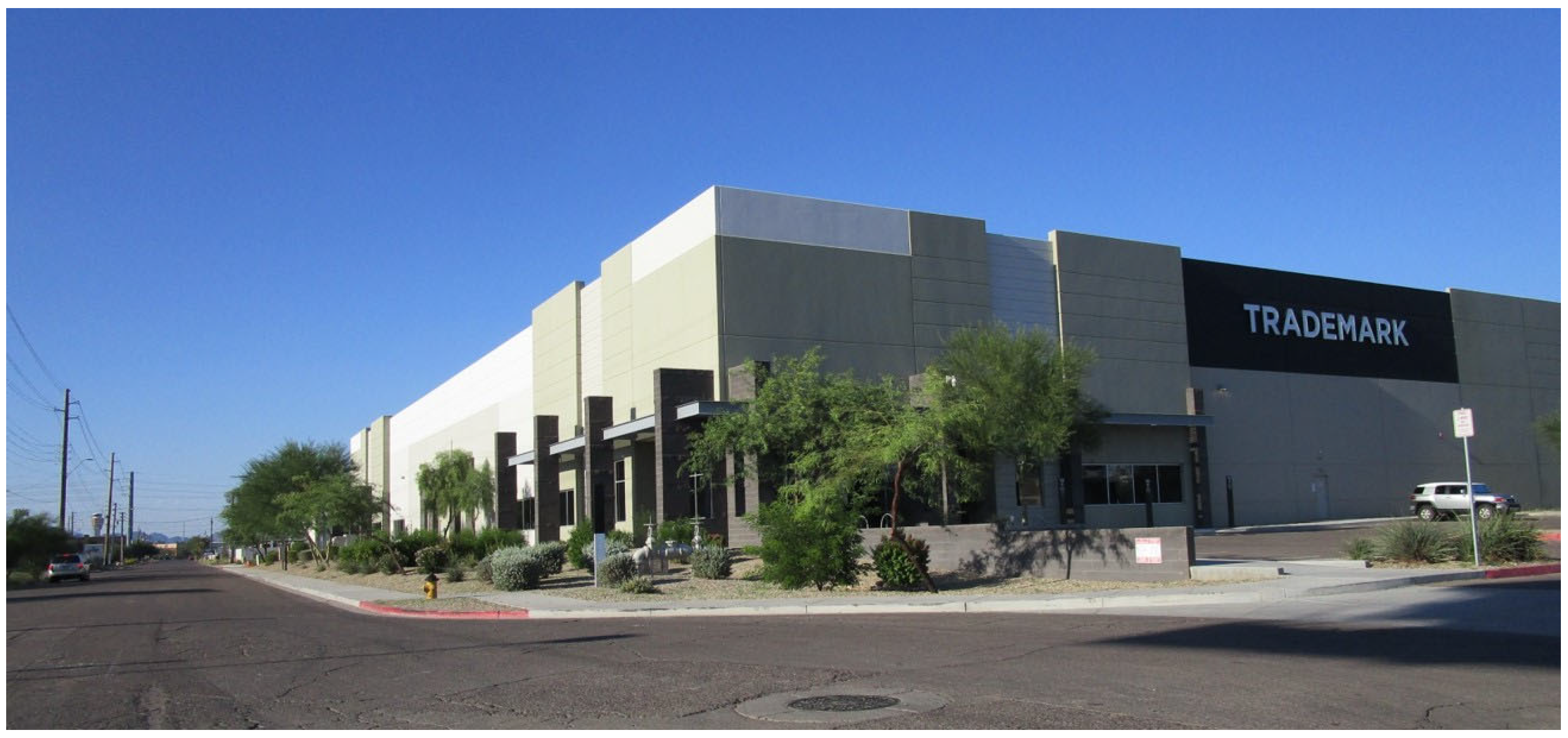
59], which brought together elected officials, property and business owners, and economic development specialists to further improve the central area of the metropolis. Specific examples of urban industrial retrofit strategy at the site level were observable during repeated visits several years apart at the
cul-de-sac on 36th and E. Illini Streets (
Figure 7).
A specific limitation of this study is its reliance on one main case study, the Wedge South Mountain industrial district. Even though relatively similar cases elsewhere in the United States (i.e., Kansas City, MI; Buffalo, NY; Seattle, WA; Portland, OR—see
Table 2) were identified, consulted, and analyzed in terms of their transformations, planning instruments, and governance mechanisms, it is recognized that additional research can increase the robustness of the Phoenix case. Subsequent research ought to also make use of more systematic analyses and to potentially rely more on both quantitative and qualitative indicators to measure the implementation of planning objectives and strategies, to identify funding sources as well as entities capable of implementing the planning recommendations via phased interventions. The identification of examples of successful cases of small business protection and green transformation in comparable regions and stages of development can shed further light on the analysis and findings identified in this study.
In synthesis, these recommendations for further research and scholarship on industrial and commercial planning in the U.S. Sunbelt aerotropolises result from the realization that currently and in this geo-climatic region; there is pressure to either not plan industrial areas or to convert some centrally located industrially zoned lands to sports, entertainment, and in certain cases, residential uses. The Urban Planning Studio called attention to have public authorities place the same level of care in their production-oriented land uses as their private counterpart developers place on their often heavily publicly subsidized consumption-oriented uses.
Eco-industrial parks comprising a variety of lot sizes, an array of complementary businesses, multiple levels of utility generation and sharing arrangements, renewable energy sources, and coordinated management practices of grounds, labor pools and access to capital, as well as the timely attenuation of environmental and social impacts appear to characterize the most productive advanced manufacturing areas in other parts of the nation and the world [
74], and certainly ought to also be pursued in the U.S. Sunbelt. The article closes with a Sunbelt Industrial Land Retrofit Agenda based on the following five-pronged approach focusing on (i) Industry 4.0; (ii) circular economy; (iii) green transformation of industrial urban land; (iv) central urban areas of the Sunbelt region; and (v) industrial district retrofit via industrial land conservation.
Figure 7.
Recently constructed industrial building [
75].
Figure 7.
Recently constructed industrial building [
75].