The Slope Association Type as a Comparative Index for the Evaluation of Environmental Risks
Abstract
:1. Introduction
2. Materials and Methods
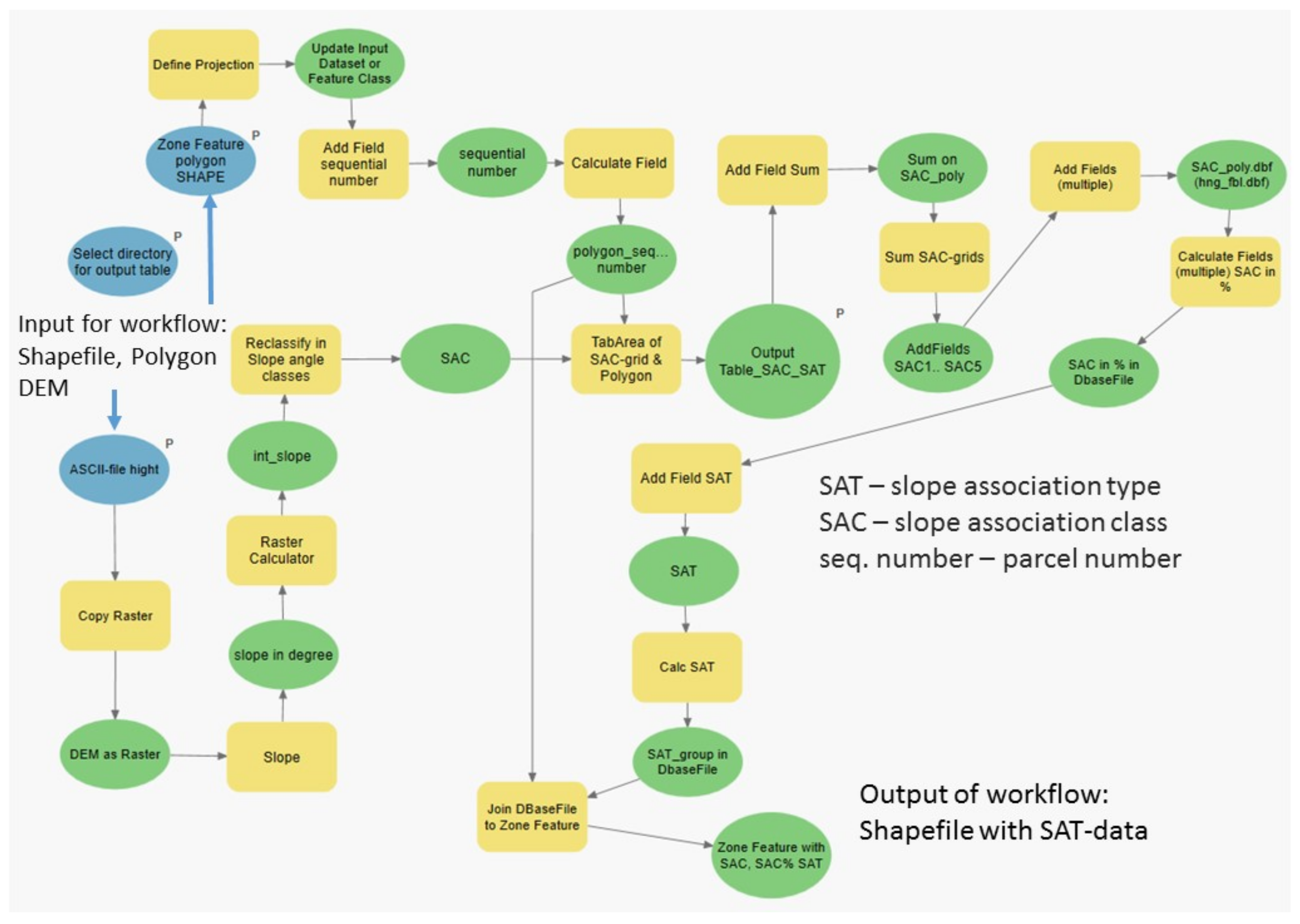
- Calculation of the slope’s inclination of the raster (DEM1 or DEM10);
- Reclassification of slope inclinations into SACs;
- Calculation of SAC’s units per reference area;
- Join resulting SAC units (SAC1–5 as area sum and area portion, SAT01–11 or numbered from 1 to 6, see Table 1) to the respective reference area (initial polygons);
- Thus, the combining assessment can be displayed on the map. With the identifier, the individual values from the table can be queried, or the table itself can be further processed for evaluation.
3. Results
4. Discussion
5. Conclusions
Author Contributions
Funding
Institutional Review Board Statement
Informed Consent Statement
Data Availability Statement
Acknowledgments
Conflicts of Interest
References
- European Soil Data Centre. European Soil Database Maps. Available online: https://esdac.jrc.ec.europa.eu/resource-type/european-soil-database-maps (accessed on 14 October 2021).
- Panagos, P.; Borrelli, P.; Meusburger, K. A New European Slope Length and Steepness Factor (LS-Factor) for Modeling Soil Erosion by Water. Geosciences 2015, 5, 117–126. [Google Scholar] [CrossRef] [Green Version]
- E.C. The Common Agricultural Policy at a Glance. Available online: https://ec.europa.eu/info/food-farming-fisheries/key-policies/common-agricultural-policy/cap-glance_en (accessed on 25 October 2021).
- Haase, G.; Hubrich, H.; Schlüter, H.; Mannsfeld, K.; Kugler, H.; Richter, H.; Barsch, H.; Kopp, D.; Schwanecke, W. Kennzeichnung und Kartierung von Naturraumtypen im mittleren Maßstabsbereich. Leipzig; Institut für Geographie und Geoökologie der AdW der DDR: Leipzig, Germany, 1982; p. 152. [Google Scholar]
- Gündra, H.; Assmann, A.; Jäger, S. Geomorphometrische Parameter mit hydrologischer Relevanz und die Qualität der zugrunde liegenden Digitalen Höhenmodelle. Hydrol. Wasserbewirtsch. 2000, 44, 114–121. [Google Scholar]
- Chifflard, P. Der Einfluss des Reliefs, der Hangsedimente und der Bodenvorfeuchte auf die Abflussbildung im Mittelgebirge—Experimentelle Prozess-Studien im Sauerland; Im Selbstverlag: Bochum, Germany, 2006; Volume Heft 76. [Google Scholar]
- Deumlich, D.; Schmidt, R.; Sommer, M. A multiscale soil–landform relationship in the glacial-drift area based on digital terrain analysis and soil attributes. J. Plant. Nutr. Soil Sci. 2010, 173, 843–851. [Google Scholar] [CrossRef]
- Kugler, H. Naturraumtypen des Ballungsraumes Leipzig Einschließlich Eines 1. Entwurfs zur Kennzeichnung des Reliefs im Rahmen der NK100; Martin-Luther-Univ: Halle, Germany, 1979; Manuscript 79/15. [Google Scholar]
- TGL. Aufnahme landwirtschaftlicher Standorte Georelief. In TGL 24300/03; TGL: Berlin, Germany, 1985; p. 6. [Google Scholar]
- Estler, M.; Pfahler, K. Einfluß der Hangneigung auf den Wert Landwirtschaftlicher Grundstücke; Bayerisches Staatsministerium für Ernährung, Landwirtschaft und Forsten: München, Germany, 1985; Volume Heft 8, p. 163. [Google Scholar]
- Ullrich, G.; Stengler, K.H. Arbeitssicherheit beim Einsatz von Traktoren und Landmaschinen im Hängigen Gelände; Verl. Tribuene: Berlin, Germany, 1971. [Google Scholar]
- Rothkegel, W. Landwirtschaftliche Schätzungslehre; Eugen Ulmer: Stuttgart, Germany, 1952. [Google Scholar]
- Greif, F. Raumstruktur-Inventar für das Österreichische Bundesgebiet. Eine Methodik zur Quantifizierung von Höhenlage, Hangneigung und Exposition; Agrarwirtschaftliches Institut des Bundesministeriums für Land- und Forstwirtschaft: Wien, Austria, 1980. [Google Scholar]
- ad-hoc-AG-Boden. Bodenkundliche Kartieranleitung. KA5; Schweizerbart’sche Verlagsbuchhandlung Stuttgart: Stuttgart, Germany, 2006; p. 468. [Google Scholar]
- Kasch, W.; Flegel, R. Landwirtschaftliche Bedeutung, Erfassung und Kennzeichnung der Reliefverhältnisse. Feldwirtschaft 1975, 1, 4. [Google Scholar]
- Diemann, R. Reliefsystematik auf der Grundlage der MMK. In Arch. Acker-u. Pflanzenbau u. Bodenkd; Akademie Verlag: Berlin, Germany, 1980; pp. 469–474. [Google Scholar]
- Schmidt, R.; Diemann, R.; Thiere, J.; Bickenbach, J.; Strohbach, B.; Succow, M.; Wünsche, M. Erläuterungen zur Mittelmaßstäbigen Landwirtschaftlichen Standortkartierun (MMK); Akademie Verlag: Eberswalde, Germany, 1981; p. 78. [Google Scholar]
- Reiher, W.; Grafe, B. Informationssystem Bodenführung ISBO—Anwenderhandbuch; Informationssystem Bodenführung: Markkleeberg, Germany, 1989; p. 95. [Google Scholar]
- Lieberoth, I.; Dunkelgod, P.; Gunia, W.; Thiere, J. Auswertungsrichtlinie MMK (Stand 1983); Akademieverlag: Berlin, Germany, 1983; p. 55. [Google Scholar]
- Klečka M. a kol. Bonitace čs. Zemědělských půd a Směry Jejich Využití. 1. díl, Vymezení a Mapování Bonitovaných Půdně–Ekologických Jednotek ČSSR. Uživatelská Příručka pro Užívání Map BPEJ; Federální Ministerstvo Zemědělství a Výživy: Praha-Bratislava, Slovakia, 1984; p. 131. [Google Scholar]
- Vitejte v eKatalogu BPE, JVÚMOP. Available online: https://bpej.vumop.cz/ (accessed on 25 October 2021).
- Koćmit, A.; Niedźwiecki, E.; Zabłocki, Z. Gleboznawstwo z Elementami Geologii; Wydawnictwo Akademii Rolniczej: Szczecin, Poland, 1990. [Google Scholar]
- Borrelli, P.; Alewell, C.; Alvarez, P.; Anache, J.A.A.; Baartman, J.; Ballabio, C.; Bezak, N.; Biddoccu, M.; Cerdà, A.; Chalise, D.; et al. Soil erosion modelling: A global review and statistical analysis. Sci. Total Environ. 2021, 780, 146494. [Google Scholar] [CrossRef] [PubMed]
- ESRI. ArcGIS Desktop: Release 10; Environmental Systems Research Institute: Redlands, CA, USA, 2011. [Google Scholar]
- Deumlich, D.; Dannowski, R.; Völker, L. Historische und aktuelle Geoinformation—Grundlage in der Agrarlandschaftsforschung. ZFV Z. Geodäsie Geoinf. Landmanag. 2014, 139, 329–341. [Google Scholar] [CrossRef]
- BfJ. Verordnung über die Anwendung von Düngemitteln, Bodenhilfsstoffen, Kultursubstraten und Pflanzenhilfsmitteln Nach den Grundsätzen der Guten Fachlichen Praxis Beim Düngen. 2017. Available online: https://www.gesetze-im-internet.de/d_v_2017/BJNR130510017.html (accessed on 14 October 2021).
- FAO. Guidelines for Soil Description; FAO: Rome, Italy, 2006. [Google Scholar]
- LGB. Digitales Geländemodell (DGM). Available online: https://geobroker.geobasis-bb.de/gbss.php?MODE=GetProductInformation&PRODUCTID=488a2b53-564f-43eb-88ec-0d87bb43ed20 (accessed on 14 October 2021).
- Katzur, L.; Schönitz, A.; Wedel, H. Digitale Höhen für jeden Quadratmeter Brandenburgs; Vermessung Brandenburg, MdI Brandenburg: Potsdam, Germany, 2013; p. 8. [Google Scholar]
- InVeKoS-DZ. Digitales Feldblock Kataster; Landesvermessung und Geobasisinformation Brandenburg (LGB): Potsdam, Germany, 2020. [Google Scholar]
- Meynen, E.; Schmithüsen, J. Handbuch der naturräumlichen Gliederung Deutschlands/unter Mitwirkung des Zentralausschusses für Deutsche Landeskunde, 1953–1962; Bundesanst für Landeskunde u. Raumforschung: Bad Godesberg, Germany, 1962; p. 608S. [Google Scholar]
- EUROSTAT. NUTS—Nomenclature of Territorial Units for Statistics. Available online: https://ec.europa.eu/eurostat/web/nuts/background (accessed on 14 October 2021).
- ESRI. What Is ModelBuilder? ESRI: West Redlands, CA, USA; Available online: https://pro.arcgis.com/de/pro-app/latest/help/analysis/geoprocessing/modelbuilder/what-is-modelbuilder-.htm (accessed on 20 November 2021).
- Panagos, P.; Pasquale, B.; Jean, P.; Cristiano, B.; Emanuele, L.; Katrin, M.; Luca, M.; Christine, A. The new assessment of soil loss by water erosion in Europe. Environ. Sci. Policy 2015, 54, 438–447. [Google Scholar] [CrossRef]
- Fohrer, N.; Mollenhauer, K.S.; Thomas, B. Nationalatlas Bundesrepublik Deutschland; Liedtke, H.M., Roland, S., Karl, H., Eds.; Spektrum Akad. Verl.: Heidelberg/Berlin, Germany, 2003; Volume 2, p. 173. [Google Scholar]
- Nitsch, H.; Osterburg, B.; Roggendorf, W. Landwirtschaftliche Flächennutzung im Wandel–Folgen für Natur und Landschaft; NABU-Bundesverband & Deutscher Verband für Landschaftspflege (DVL) e.V.: Berlin, Germany, 2009; p. 39. [Google Scholar]
- Küster, H. Geschichte der Landschaft in Mitteleuropa: Von der Eiszeit bis zur Gegenwart; Beck: München, Germany, 1996. [Google Scholar]
- Krenzlin, A. Dorf, Feld und Wirtschaft im Gebiet der großen Täler und Platten östlich der Elbe: Eine Siedlungsgeographische Untersuchung; Verl. d. Amtes f. Landeskunde: Remagen, Germany, 1952; p. 144. [Google Scholar]
- Bork, H.R.; Bork, H.; Dalchow, C.; Faust, B.; Piorr, H.-P.; Schatz, T. Landschaftsentwicklung in Mitteleuropa; Klett-Perthes: Gotha, Germany; Stuttgart, Germany, 1998. [Google Scholar]
- Deumlich, D.; Kiesel, J.; Thiere, J.; Reuter, H.-I.; Völker, L.; Funk, R. Application of the SIte COmparison Method (SICOM) to assess the potential erosion risk—A basis for the evaluation of spatial equivalence of agri-environmental measures. Catena 2006, 68, 141–152. [Google Scholar] [CrossRef]
- Ministerium für Landwirtschaft. Mluk. Cross Compliance 2021; Umwelt und Klimaschutz des Landes Brandenburg: Potsdam, Germany, 2020; p. 115. [Google Scholar]
- MLUK. Digitales Feldblockkataster GIS InVeKoS. Available online: https://maps.brandenburg.de/WebOffice/?project=DFBK_www_CORE (accessed on 15 November 2021).
- Thiere, J. Zu einigen Problemen der Entwicklung und Systematik landwirtschaftlich genutzter Böden. Wiss. Zschr. Humboldt-Univ. Berlin Math.-Nat. R. 1972, XXl, 288–296. [Google Scholar]
| Original Criterion to Estimate the Slope Association Type (SAT) | |||||||
|---|---|---|---|---|---|---|---|
| Slope Association Type | Summarized Slope Angle Classes (SSAC I–V) | ||||||
| Slope Angle Classes (SAC 0–8) | |||||||
| Symbol | No. | Description | I | II | III | IV | V |
| 0 | 1 | 2/3 | 4/5 | 6–8 | |||
| <4% | 4–9% | 9–14% | 14–23% | >23% | |||
| 01 | 0 | Plane | ≥95 | ≤5 | 0 | ||
| 03 | 1 | Flat | ≥60–80 | ≤40 | ≤5 | 0 | |
| 05 | 2 | Flat with moderate inclined portions | ≥80 | ≤20 | ≤5 | 0 | |
| 07 | 3 | Flat with strong inclined portions | ≥80 | ≤20 | ≤5 | ||
| 09 | 4 | Moderate with strong inclined portions | ≥40–60 | ≥20–40 | ≤20 | ≤5 | |
| 11 | 5 | Strong inclined | ≥40–60 | ≥40–60 | |||
| Slope Association Type (SAT) | Combined Slope Angle Classes (SAC) 1 Slope Angle Criterion 2,3 | |||||
|---|---|---|---|---|---|---|
| 1 | 2 | 3 | 4 | 5 | ||
| Symbol 4 Nr/SAT | Description | ≤4% 2 ≤2%3 | 4%–≤9% 2%–≤4% | 9%–≤14% 4%–≤8% | 14%–≤23% 8%–≤13% | >23% >13% |
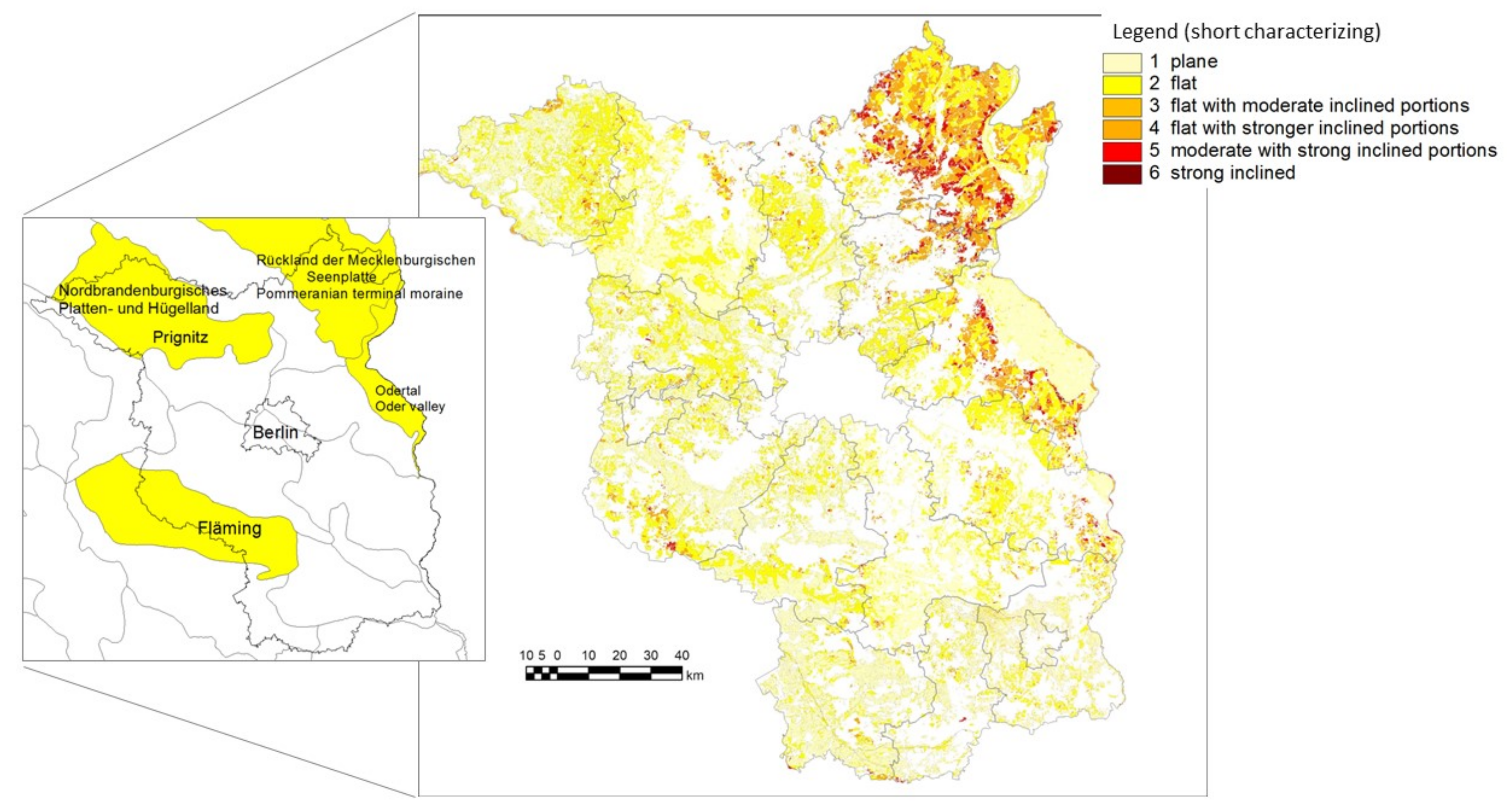
| 1/01 | Plane | ≥95 | ≤5 | 0 | ||
| 2/03 | Flat | ≥60 | ≤40 | 0 | ||
| 3/05 | Flat with moderate inclined portions | ≥80 | ≤20 | ≤5 | 0 | |
| 4/07 | Flat with stronger inclined portions | ≥80 | ≤20 | ≤5 | ||
| 5/09 | Moderate with strong inclined portions | ≥70 | <30 | |||
| 6/11 | Strong inclined | <70 | ≥30 | |||
| Area Share of LPIS | Area Share of County Area | ||||||||||
|---|---|---|---|---|---|---|---|---|---|---|---|
| County Name | SAC1 | SAC2 | SAC3 | SAC4 | SAC5 | Share of AF | SAC1 | SAC2 | SAC3 | SAC4 | SAC5 |
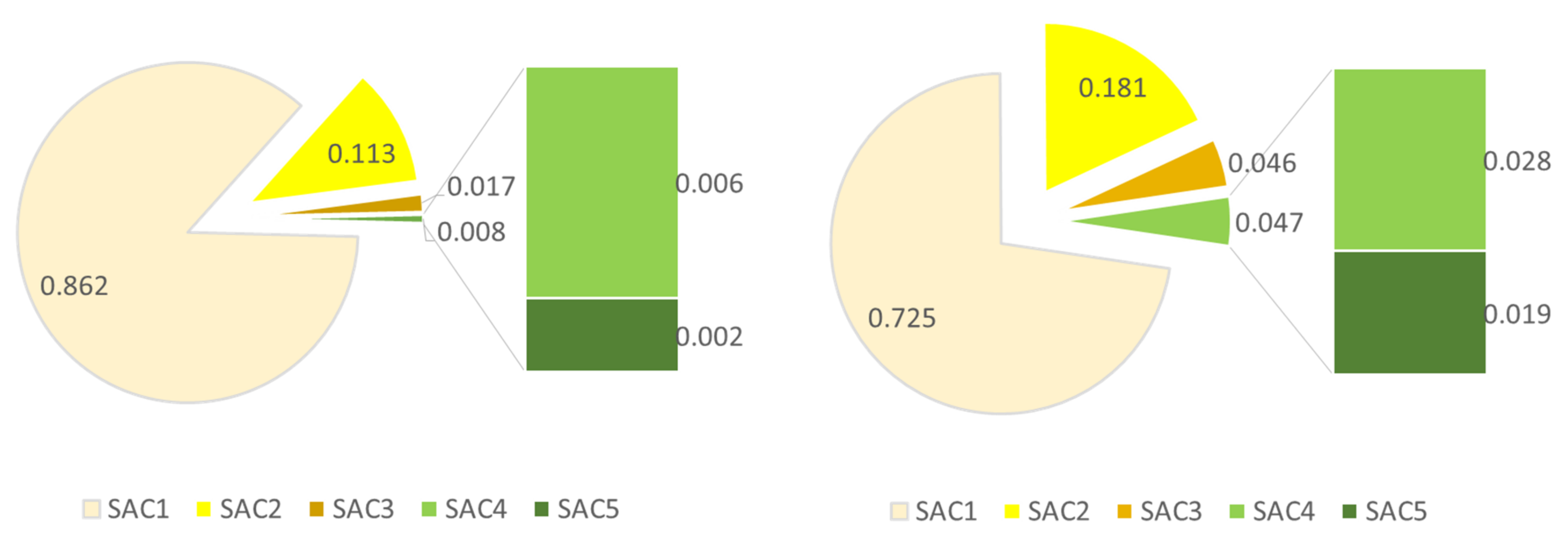
| Barnim | 0.749 | 0.195 | 0.038 | 0.015 | 0.004 | 0.330 | 0.611 | 0.236 | 0.074 | 0.049 | 0.030 |
| Dahme-Spreewald | 0.910 | 0.076 | 0.009 | 0.003 | 0.001 | 0.353 | 0.744 | 0.173 | 0.045 | 0.025 | 0.013 |
| Elbe-Elster | 0.943 | 0.046 | 0.006 | 0.003 | 0.002 | 0.484 | 0.802 | 0.140 | 0.028 | 0.017 | 0.013 |
| Havelland and Potsdam | 0.915 | 0.075 | 0.007 | 0.002 | 0.001 | 0.506 | 0.761 | 0.158 | 0.040 | 0.025 | 0.015 |
| Märkisch-Oderland | 0.811 | 0.147 | 0.029 | 0.010 | 0.003 | 0.581 | 0.678 | 0.193 | 0.058 | 0.038 | 0.033 |
| Oberhavel | 0.877 | 0.104 | 0.012 | 0.005 | 0.002 | 0.394 | 0.731 | 0.177 | 0.046 | 0.029 | 0.016 |
| Oder-Spree and Frankfurt/O. | 0.805 | 0.167 | 0.020 | 0.006 | 0.002 | 0.346 | 0.679 | 0.204 | 0.056 | 0.036 | 0.024 |
| Oberspreewald-Lausitz | 0.932 | 0.058 | 0.006 | 0.003 | 0.001 | 0.300 | 0.759 | 0.160 | 0.034 | 0.024 | 0.023 |
| Ostprignitz | 0.903 | 0.085 | 0.008 | 0.003 | 0.001 | 0.512 | 0.784 | 0.152 | 0.033 | 0.019 | 0.012 |
| Prignitz | 0.904 | 0.082 | 0.008 | 0.004 | 0.003 | 0.646 | 0.802 | 0.143 | 0.028 | 0.016 | 0.011 |
| Potsdam-Mittelmark and Brandenburg | 0.891 | 0.097 | 0.009 | 0.002 | 0.000 | 0.396 | 0.732 | 0.189 | 0.042 | 0.023 | 0.014 |
| Spree-Neiße and Cottbus | 0.920 | 0.068 | 0.007 | 0.003 | 0.002 | 0.319 | 0.751 | 0.160 | 0.036 | 0.025 | 0.028 |
| Teltow-Fläming | 0.925 | 0.067 | 0.005 | 0.002 | 0.001 | 0.431 | 0.764 | 0.165 | 0.037 | 0.021 | 0.013 |
| Uckermark | 0.585 | 0.313 | 0.074 | 0.025 | 0.004 | 0.575 | 0.558 | 0.289 | 0.086 | 0.045 | 0.022 |
| Natural Area | Aggregated on LPIS (Parcel Sum) | AF Rel. | Aggregated on Natural Area [31] | ||||||||||
|---|---|---|---|---|---|---|---|---|---|---|---|---|---|
| SAC1 | SAC2 | SAC3 | SAC4 | SAC5 | km2 | (LPIS) | SAC1 | SAC2 | SAC3 | SAC4 | SAC5 | km2 | |
| Sächsisches Hügelland (einschl. Leipziger Land) | 0.618 | 0.320 | 0.051 | 0.010 | 0.001 | 7.07 | 0.443 | 0.489 | 0.320 | 0.090 | 0.051 | 0.050 | 15.96 |
| Rückland der Mecklenburgischen Seenplatte | 0.557 | 0.333 | 0.080 | 0.026 | 0.004 | 1659.09 | 0.649 | 0.526 | 0.308 | 0.094 | 0.049 | 0.022 | 2555.74 |
| Mecklenburgische Seenplatte | 0.714 | 0.225 | 0.044 | 0.014 | 0.003 | 373.38 | 0.202 | 0.598 | 0.247 | 0.080 | 0.050 | 0.025 | 1849.31 |
| Südwestliches Vorland der Mecklenburgischen Seenplatte | 0.937 | 0.050 | 0.008 | 0.004 | 0.001 | 0.39 | 0.358 | 0.593 | 0.184 | 0.106 | 0.083 | 0.034 | 1.08 |
| Nordbrandenburgisches Platten-und Hügelland | 0.894 | 0.094 | 0.008 | 0.003 | 0.001 | 2342.95 | 0.572 | 0.790 | 0.155 | 0.029 | 0.016 | 0.010 | 4096.68 |
| Luchland | 0.930 | 0.060 | 0.006 | 0.003 | 0.001 | 1211.66 | 0.571 | 0.805 | 0.131 | 0.031 | 0.020 | 0.012 | 2121.71 |
| Ostbrandenburgische Platte | 0.746 | 0.207 | 0.033 | 0.011 | 0.003 | 1204.92 | 0.480 | 0.622 | 0.238 | 0.066 | 0.042 | 0.032 | 2508.42 |
| Odertal (Oder valley) | 0.918 | 0.056 | 0.013 | 0.008 | 0.005 | 720.37 | 0.655 | 0.805 | 0.111 | 0.032 | 0.025 | 0.027 | 1099.06 |
| Mittelbrandenburgische Platten und Niederungen | 0.922 | 0.069 | 0.007 | 0.002 | 0.001 | 1547.29 | 0.430 | 0.770 | 0.153 | 0.038 | 0.024 | 0.015 | 3598.37 |
| Ostbrandenburgisches Heide-und Seengebiet | 0.838 | 0.136 | 0.018 | 0.006 | 0.002 | 1007.88 | 0.266 | 0.683 | 0.203 | 0.058 | 0.035 | 0.022 | 3784.48 |
| Spreewald | 0.955 | 0.036 | 0.005 | 0.003 | 0.001 | 411.02 | 0.447 | 0.817 | 0.117 | 0.029 | 0.020 | 0.017 | 918.64 |
| Lausitzer Becken und Heideland | 0.930 | 0.062 | 0.005 | 0.002 | 0.001 | 982.85 | 0.355 | 0.764 | 0.162 | 0.032 | 0.021 | 0.021 | 2768.81 |
| Fläming | 0.882 | 0.106 | 0.009 | 0.002 | 0.000 | 1007.88 | 0.427 | 0.715 | 0.211 | 0.042 | 0.021 | 0.011 | 2358.70 |
| Elbtalniederung | 0.919 | 0.062 | 0.009 | 0.005 | 0.005 | 457.15 | 0.445 | 0.787 | 0.140 | 0.036 | 0.023 | 0.014 | 1026.56 |
| Elbe-Mulde-Tiefland | 0.947 | 0.042 | 0.005 | 0.003 | 0.002 | 621.48 | 0.595 | 0.828 | 0.117 | 0.025 | 0.017 | 0.013 | 1045.13 |
| Oberlausitzer Heideland | 0.919 | 0.057 | 0.012 | 0.008 | 0.004 | 65.46 | 0.178 | 0.748 | 0.164 | 0.034 | 0.025 | 0.028 | 367.57 |
| GIS-ID | SAC1 | SAC2 | SAC3 | SAC4 | SAC5 | sum | SAC1_rel | SAC2_rel | SAC3_rel | SAC4_rel | SAC5_rel | SAT | Area |
|---|---|---|---|---|---|---|---|---|---|---|---|---|---|
| No. | m2 | % | ha | ||||||||||
| 4069 | 341,644 | 128,424 | 106,752 | 152,844 | 138,196 | 867,860 | 39.37 | 14.80 | 12.30 | 17.61 | 15.92 | 6 | 86.8 |
| 1798 | 324,216 | 383,368 | 95,000 | 11,252 | 56 | 813,892 | 39.84 | 47.10 | 11.67 | 1.38 | 0.01 | 3 | 81.4 |
| 5410 | 239,832 | 256,768 | 99,728 | 26,924 | 948 | 624,200 | 38.42 | 41.14 | 15.98 | 4.31 | 0.15 | 5 | 62.4 |
| 4345 | 229,672 | 223,772 | 89,856 | 41,980 | 5740 | 591,020 | 38.86 | 37.86 | 15.20 | 7.10 | 0.97 | 5 | 59.1 |
| 4139 | 350,444 | 82,296 | 47,248 | 26,980 | 1600 | 508,568 | 68.91 | 16.18 | 9.29 | 5.31 | 0.31 | 4 | 50.9 |
| 4520 | 195,612 | 257,496 | 48,488 | 6488 | 24 | 508,108 | 38.50 | 50.68 | 9.54 | 1.28 | 0.00 | 3 | 50.8 |
| 2992 | 213,056 | 241,080 | 43,160 | 11,264 | 68 | 508,628 | 41.89 | 47.40 | 8.49 | 2.21 | 0.01 | 3 | 50.9 |
| 5247 | 230,720 | 122,000 | 72,528 | 54,356 | 7992 | 487,596 | 47.32 | 25.02 | 14.87 | 11.15 | 1.64 | 5 | 48.8 |
| 4782 | 183,368 | 171,640 | 56,432 | 22,984 | 3500 | 437,924 | 41.87 | 39.19 | 12.89 | 5.25 | 0.80 | 4 | 43.8 |
| 500 | 221,056 | 121,364 | 46,264 | 31,736 | 10,776 | 431,196 | 51.27 | 28.15 | 10.73 | 7.36 | 2.50 | 5 | 43.1 |
| 1950 | 399,064 | 27,672 | 1728 | 388 | 96 | 428,948 | 93.03 | 6.45 | 0.40 | 0.09 | 0.02 | 2 | 42.9 |
| 2938 | 414,236 | 7964 | 1688 | 1280 | 708 | 425,876 | 97.27 | 1.87 | 0.40 | 0.30 | 0.17 | 1 | 42.6 |
| 3850 | 314,416 | 105,744 | 4340 | 468 | 696 | 425,664 | 73.86 | 24.84 | 1.02 | 0.11 | 0.16 | 2 | 42.6 |
| 4824 | 421,672 | 3712 | 132 | 16 | 8 | 425,540 | 99.09 | 0.87 | 0.03 | 0.00 | 0.00 | 1 | 42.6 |
| 728 | 36,236 | 100,296 | 47,544 | 6820 | 20 | 190,916 | 18.98 | 52.53 | 24.90 | 3.57 | 0.01 | 5 | 19.1 |
| 4343 | 36,744 | 48,060 | 30,164 | 40,336 | 12,112 | 167,416 | 21.95 | 28.71 | 18.02 | 24.09 | 7.23 | 6 | 16.7 |
| 2272 | 6836 | 24,872 | 42,140 | 64,120 | 28,012 | 165,980 | 4.12 | 14.98 | 25.39 | 38.63 | 16.88 | 6 | 16.6 |
| 2483 | 36,304 | 80,816 | 24,740 | 6920 | 92 | 148,872 | 24.39 | 54.29 | 16.62 | 4.65 | 0.06 | 5 | 14.9 |
| 1667 | 17,448 | 34,124 | 33,612 | 38,436 | 23,872 | 147,492 | 11.83 | 23.14 | 22.79 | 26.06 | 16.19 | 6 | 14.7 |
| 2379 | 31,800 | 20,868 | 8824 | 12,624 | 5328 | 79,444 | 40.03 | 26.27 | 11.11 | 15.89 | 6.71 | 5 | 7.9 |
| 4788 | 34,800 | 17,976 | 7108 | 2492 | 640 | 63,016 | 55.22 | 28.53 | 11.28 | 3.95 | 1.02 | 3 | 6.3 |
| 2130 | 62,172 | 2136 | 124 | 0 | 0 | 64,432 | 96.49 | 3.32 | 0.19 | 0.00 | 0.00 | 1 | 6.4 |
Publisher’s Note: MDPI stays neutral with regard to jurisdictional claims in published maps and institutional affiliations. |
© 2021 by the authors. Licensee MDPI, Basel, Switzerland. This article is an open access article distributed under the terms and conditions of the Creative Commons Attribution (CC BY) license (https://creativecommons.org/licenses/by/4.0/).
Share and Cite
Deumlich, D.; Völker, L.; Funk, R.; Koch, T. The Slope Association Type as a Comparative Index for the Evaluation of Environmental Risks. Water 2021, 13, 3333. https://doi.org/10.3390/w13233333
Deumlich D, Völker L, Funk R, Koch T. The Slope Association Type as a Comparative Index for the Evaluation of Environmental Risks. Water. 2021; 13(23):3333. https://doi.org/10.3390/w13233333
Chicago/Turabian StyleDeumlich, Detlef, Lidia Völker, Roger Funk, and Tobias Koch. 2021. "The Slope Association Type as a Comparative Index for the Evaluation of Environmental Risks" Water 13, no. 23: 3333. https://doi.org/10.3390/w13233333
APA StyleDeumlich, D., Völker, L., Funk, R., & Koch, T. (2021). The Slope Association Type as a Comparative Index for the Evaluation of Environmental Risks. Water, 13(23), 3333. https://doi.org/10.3390/w13233333


