1. Introduction
Water resources sustainability and resilient land use practices are indispensable to ecological stability and socioeconomic development. The hydrological cycle and ecosystems are influenced by the synergistic relationship between the changes in land use and land cover (LULC) and climate [
1]. Climatic variability driven by rising precipitation and temperature trends directly alters land use dynamics, thereby affecting soil moisture, plant health, and energy balance. These variations are intensified by rapid population growth and socioeconomic factors, such as industrialization, urbanization and agricultural development [
2,
3,
4], a major challenge in many West African basins. Additionally, the connection between sustainable water and population demand is a critical concern in Africa. The surge in anthropogenic pressures leads to the transformation of forests and wetlands into urban and cultivated lands, which could seriously disrupt the water balance in basins as a whole by increasing surface runoff and decreasing groundwater recharge. These alterations are expected to increase due to the rapid water demand and land use alterations, which will exacerbate warmer climatic impacts. Such changes are critical and could compromise water availability due to several unknown anthropogenic activities [
5,
6], especially in data-sparse regions. Investigating these changes [
7,
8] historically [
9,
10] and in the present-day is crucial for instituting suitable adaptation strategies [
11,
12], ensuring regional long-term water sustainability. Therefore, a comprehensible hydrological impact assessment that quantifies the intricate relationship between climate and LULC change in a basin is judicious.
Most climate change studies were conducted using climatic datasets (temperature, precipitation, wind speed and relative humidity) derived from regional climate models (RCMs) or general circulation models (GCMs). These datasets are used in the investigation of climatic variability in a changing ecology. In China, the climatic impact was investigated on runoff time, magnitude and water resources vulnerability by employing a monthly semi-distributed hydrological model [
13]. In other climatic variability studies, hydrological models were constructed to investigate the watershed response, which resulted in soil moisture loss and streamflow changes [
10,
14,
15]. The climatic effects on the regional spatiotemporal redistribution of annual temperature increase have also been studied by [
16], revealing that climate change is extremely susceptible to climate change, tending to alter the hydrological cycle [
10,
14,
15].
The changes in LULC have impacted the dynamics of the ecosystem significantly due to anthropogenic activities [
17,
18]. The LULC changes for agricultural and urbanization purposes [
19,
20] are affecting the hydrological cycle [
5] and altering rainfall, Evapotranspiration (ET) and streamflow [
21] in catchments. Especially, its projected temperature increase could eventually affect water accessibility, leading to a reduction in agricultural production and increasing food crises [
22]. The transformation of lands to various land use types has a major effect on the environment globally [
23], with the increase in human demands [
24,
25]. In a related study, the LULC from 1996 to 2018 was explored using geographic information systems and remote sensing methods to identify priority areas for sustainable land management practices for the enhancement of agricultural activities [
26].
The separate and the combined changes in LULC and climate have a significant impact on water cycle alterations globally, as suggested by many authors. For instance, under multiple scenarios, the combined impacts of LULC and climate change on hydrological parameters in the Dongjiang River basin in China were investigated [
27]. Other researchers have also investigated the land use and climate changes in the Potohar Plateau of the Indus basin in Pakistan [
28], in Ethiopia [
18], and the Pra River in Ghana [
29]. In another study, water yield and runoff increased due to infrastructural development and agricultural activities [
30], causing an increase in Evapotranspiration (ET) and runoff in the Athi basin [
31].
Employing hydrological models is essential in exploring climatic regime change and quantifying the hydrological behaviour in watersheds. In addition, utilizing hydrological models and understanding the hydrological subtleties in basins will significantly help water resources planners with appropriate hydrological designs and water management strategies [
32,
33,
34,
35]. The climatic and LULC impacts on the Miami River Basin were investigated using the Hydrological Simulation Program Fortran. Results showed that in the dry season, the basin’s variations are amplified by both impacts, and that land use change (urbanization) could help in the restoration of water availability [
36]. However, the SWAT model has stood out as the most successful hydrological model employed in basins to simulate and examine the possible implications of LULC changes to the hydrological parameters. For instance, the Rokel-Seli River Basin was investigated with an increase in runoff at the expense of forest land from 2002 to 2016, due to dam construction [
37]. A significant amount of the literature, including the Upper Blue Nile River Basin in Ethiopia [
38], the Potohar Plateau in Pakistan [
28], Talar River, in Iran [
39], the USA [
40] and the Dongjiang River, in China [
27] has suggested the SWAT model to simulate and evaluate water cycle parameters in basins.
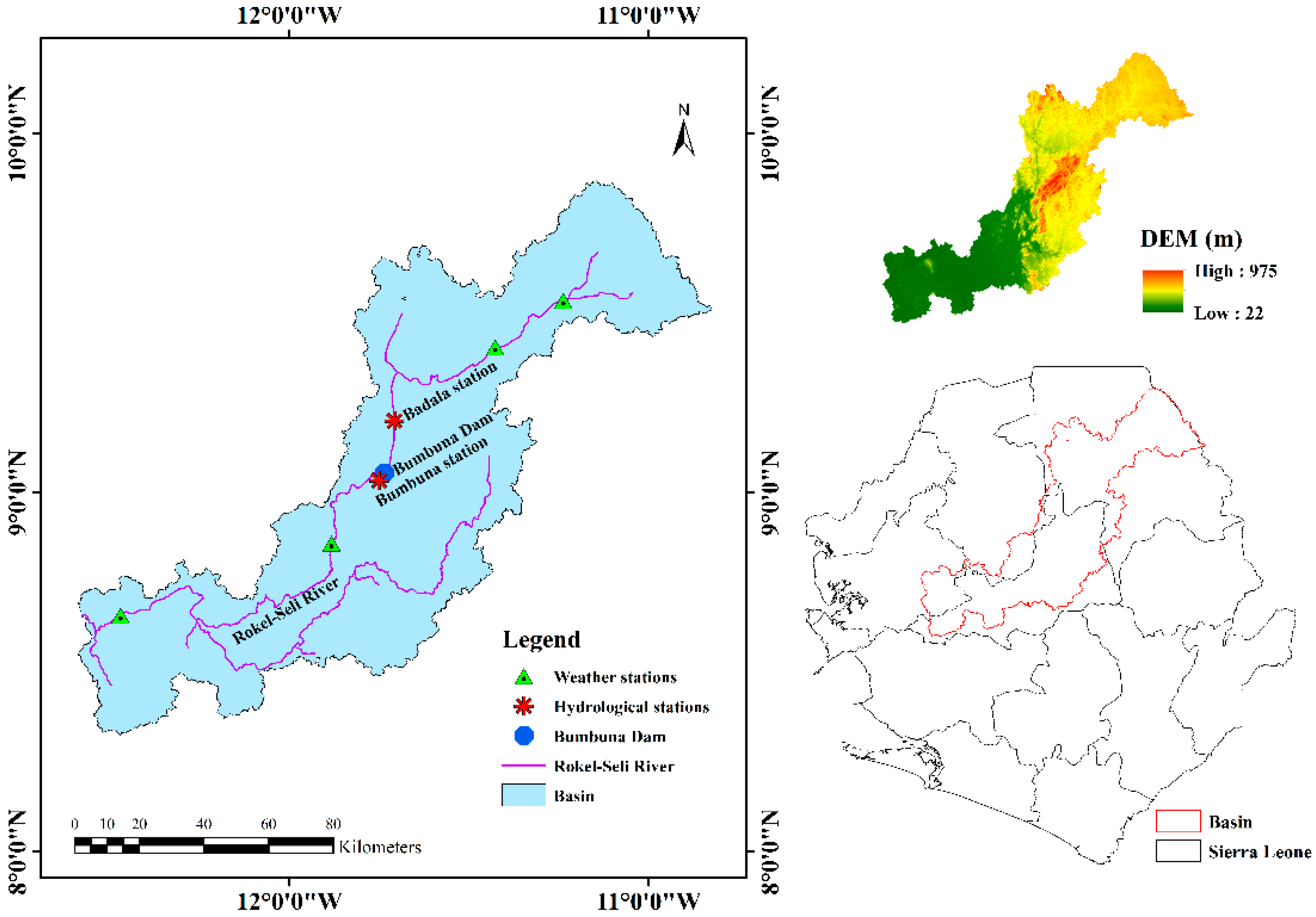
The Rokel-Seli River population growth (due to civil war migration), and infrastructural development have increased water demand, affecting the natural environment and the water cycle. In addition, the civil war has caused limitations in obtaining observed data and spurred rapid mining, timber logging and agricultural activities to satisfy human needs, making the research an arduous task to accomplish. These unaccounted activities in the basin have the potential to alter the hydrological cycle and land use. These effects, coupled with global challenges, will be intensified if appropriate measures are not taken, especially with the increasing water demand. Therefore, the need to investigate the RSRB implications of LULC changes on the hydrological cycle is obvious. Various researchers have attempted to explore these challenges in the RSRB. For instance, the Bumbuna dam expansion and rehabilitation resulted in flooding events affecting farmlands, communities and stream buffer zones due to dam overflow [
41,
42]. A related study in the RSRB by [
43] suggested that streamflow alteration is higher than agricultural demand for irrigation purposes. These anthropogenic changes could cause serious variations in the hydrological cycle, potentially threatening water availability in the basin. The Rokel-Seli River Basin has not only been increasing in deforestation, agricultural and infrastructural development, but also water contamination due to mining activities [
44]. Evaluating LULC changes in conjunction with climate variability enables the identification of the dominant variable governing surface runoff and other hydrological parameters [
13].
The severity of these activities poses a threat to change the land use and climate, and their responses to the hydrological components are critical, requiring an in-depth investigation. There have been limited explorations comparing the past and present environmental alterations in the basin, which is crucial for water sustainability and proper land use. Elucidating these alterations will foster a deeper understanding of their effects on the basin subjected to rapid agricultural and mining activities (due to population growth). This research resolves these critical gaps by leveraging downscaled temperature and precipitation datasets with observed streamflow data to construct a high-performance hydrological model, datasets that have been utilised by [
45]. The scientific merit of this study lies in the synergistic integration of its methodological framework and analytical techniques. Consistent with established literature, in the lack of observed meteorological records, reanalysis datasets offer a viable alternative for forcing hydrological models in data-scarce catchments, effectively curtail the critical bottlenecks associated with gauge networks [
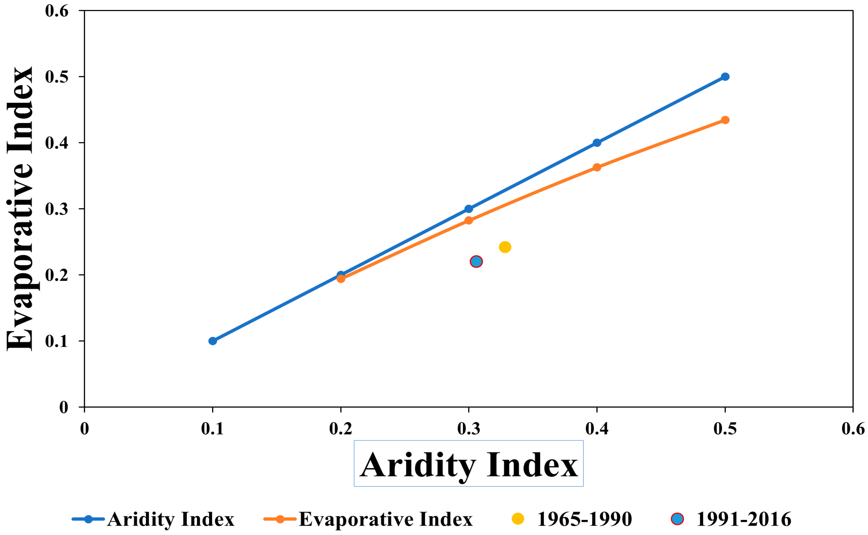
46]. To analyse the basin’s heterogeneous hydrological response and to ensure physical consistency, which quantifies water-energy portioning, this study couples the Double Mass Curve (DMC) with Budyko Framework.
This study examines the separate and combined impacts of LULC and climate change on runoff in the Rokel-Seli River Basin from 1965 to 2016. The SWAT model will be constructed using downscaled weather data and their corresponding LULC maps, using the scenario simulation technique. This study’s main objectives involve (a) estimating the LULC transformations (b) using the SWAT model to simulate and evaluate the seasonal changes of runoff and (c) estimating the basin’s hydrological regime variations in a changing environment. The results of this study could enhance stakeholders’ and decision-makers’ understanding of incorporating climate adaptation and land management strategies pertinent to water sustainability.
4. Discussion
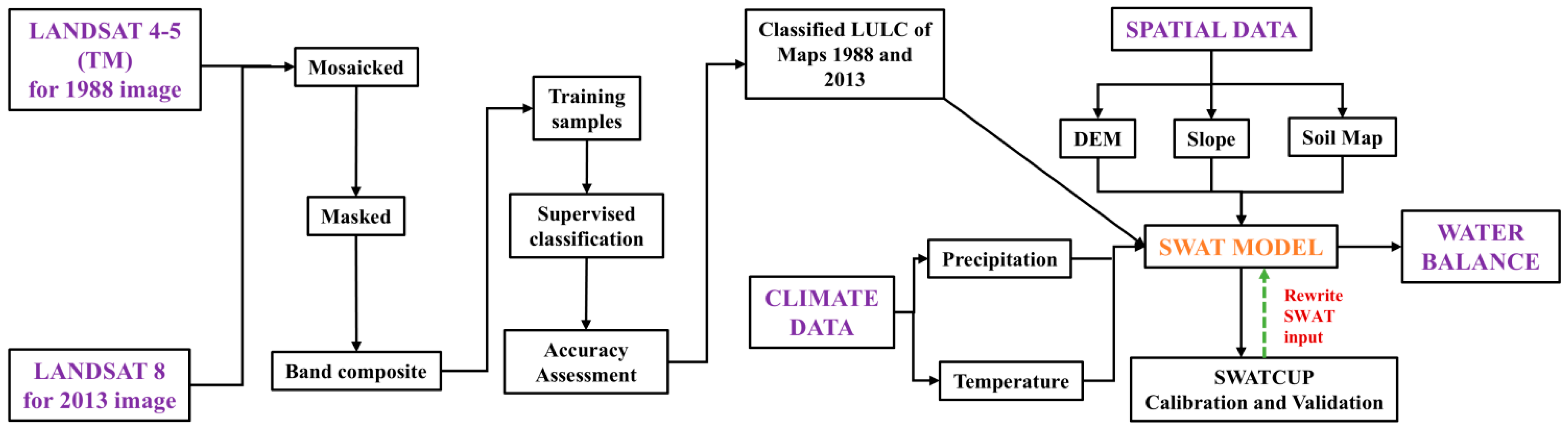
This study used satellite Landsat images from the USGS website for LULC classification. The impact of LULC changes in the Rokel-Seli River Basin was explored. The ENVI 5.3 software was used with the supervised classification technique for the 1988 and 2013 LULC images. The statistical indicator values showed strong agreement between the reference and the classified LULC images, with a kappa coefficient above 88%. According to Pandey et al. (2023) [
61], a kappa coefficient above 0.75 implies a good classification outcome.
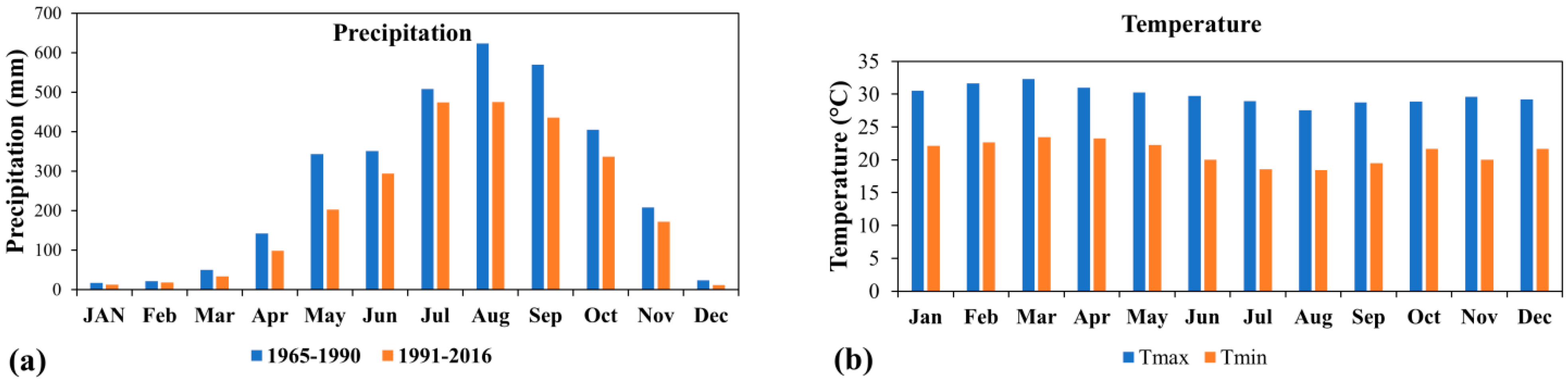
The Rokel-Seli River Basin seasonal behaviour is characterised by a complex relationship between land use and climate change. This can be attributed to (a) a water-limited regime intensified by thermal stress in the dry season (b) an energy-limited regime and saturation-excess runoff, where runoff rises because water is no longer a restraining factor in the wet season. Temperature and precipitation variations have a rational effect on the environment. Precipitation increases significantly in May and June, before the runoff peaks, indicating the soil’s storage capacity was captured by the model. Precipitation reaches its maximum in August (basin saturation state), causing excess runoff, in the West African Monsoon. The increase in runoff in the wet season is primarily due to the basin saturation state, which decreases the infiltration rate of the high monsoonal rainfall. Conversely, the decrease in runoff during the dry season can be a result of thermal stress. This triggers a competition for water, leading to a notable decrease in discharge, due to the interception of baseflow (which sustains streamflow).
The variations in temperature and precipitation have a significant effect on the ecology. For instance, precipitation decrease may affect agricultural practices, industrial activities and the Bunbuna Dam operations, especially during the dry season, with its temperature rise. Higher temperatures affect the ecosystem, which may result in a surge in the population of the blue-green algae, including its consequences [
88]. The expansion of the Bumbuna dam and reconstruction processes led to a heavy flood effect in the basin [
41] affecting agricultural farm lands and altering the general ecology. Water resources authorities have implemented flood control measures to prevent flood events by establishing a 100 m buffer zone from the riverbeds [
42]. However, constructing well-engineered infrastructures (e.g., a mini-reservoir) will prevent its recurrence and harvest rainwater during the rainy season, and mitigate water pollution. Considering drought events is imperative during the dry season, given the basin’s reliance on mining activities and cultivation. Research has shown that climate change adaptation methods that offer a sustainable water supply and increase cultivation in Ghana [
89] can also be replicated in the RSRB.
To further explore the implications of the individual and combined climate and LULC changes, seasonal runoff dynamics demonstrate that the RSRB is prone to a severe risk of water budget deficit and regime uncertainty, which will increase if these atmospheric fluctuations become significant. Results from this finding show an increase and a decrease in seasonal runoff in the RSRB under the individual and combined impact of climate and LULC changes. The Rokel-Seli River Basin seasonal runoff variations from 1965 to 2016 may have a profound impact on the nation’s economy and environment. Considering adequate planning for these variations is imperative.
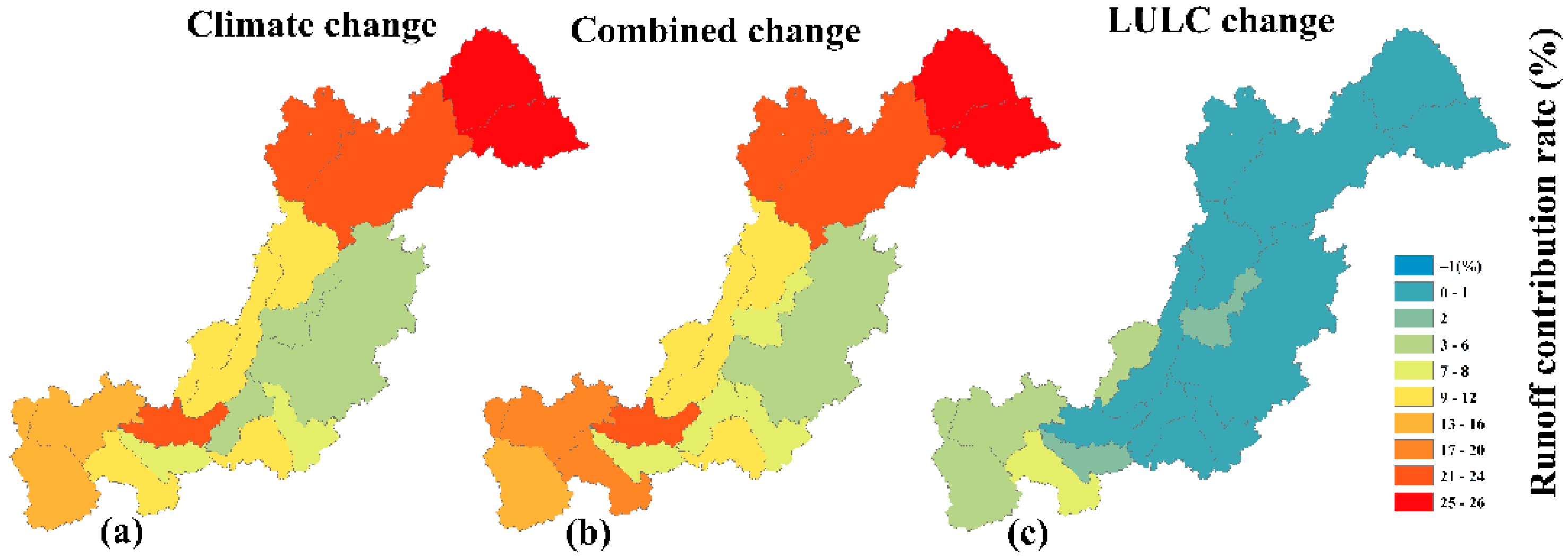
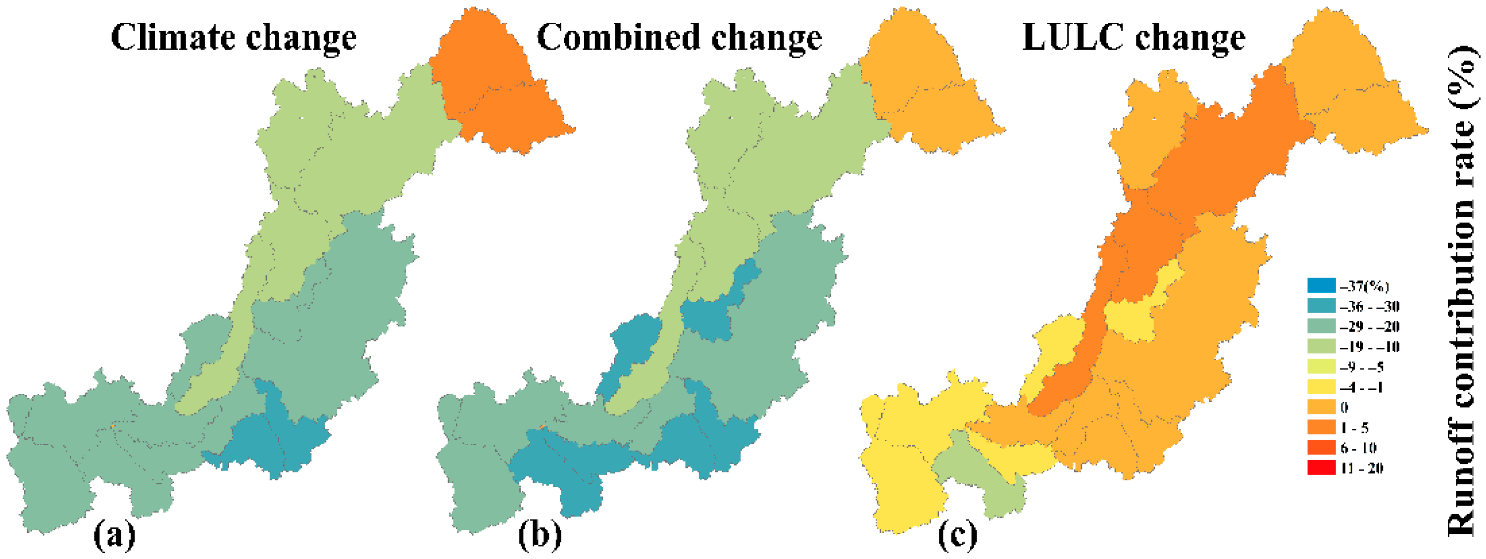
The runoff variations under climate change show a maximum increase upstream in the wet season, which corresponds with [
37] findings in the RSRB. Runoff increase tends to carry sediment, nitrate and phosphorus deposits downstream of basins [
40]. Preventing the increase in runoff outcomes due to climate change suggests the construction of a reservoir that can adequately harvest the surface runoff as a water conservation method. A study in the basin also revealed a decrease in flow due to human development [
37]. The decline in streamflow decreases the reliability of water for cultivation (e.g., irrigation) [
90], hydroelectric power supply and fishing (reducing protein sources), disturbing the river’s biodiversity. To ensure a sustainable basin, active planning and management, ecological integrity and efficacy of water consumption would enhance sustainable hydrological structure and mitigate the negative impact of the decrease in water availability.
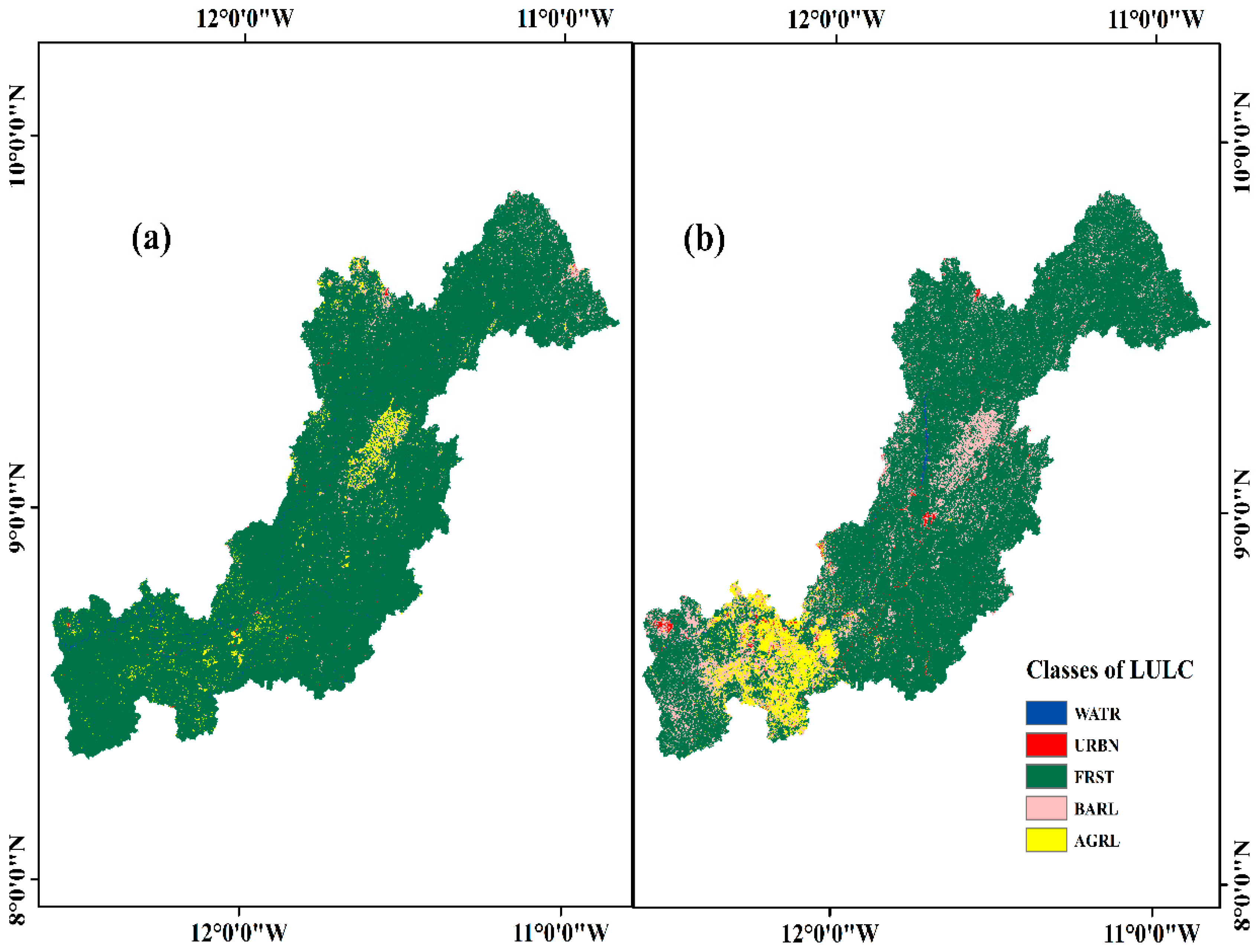
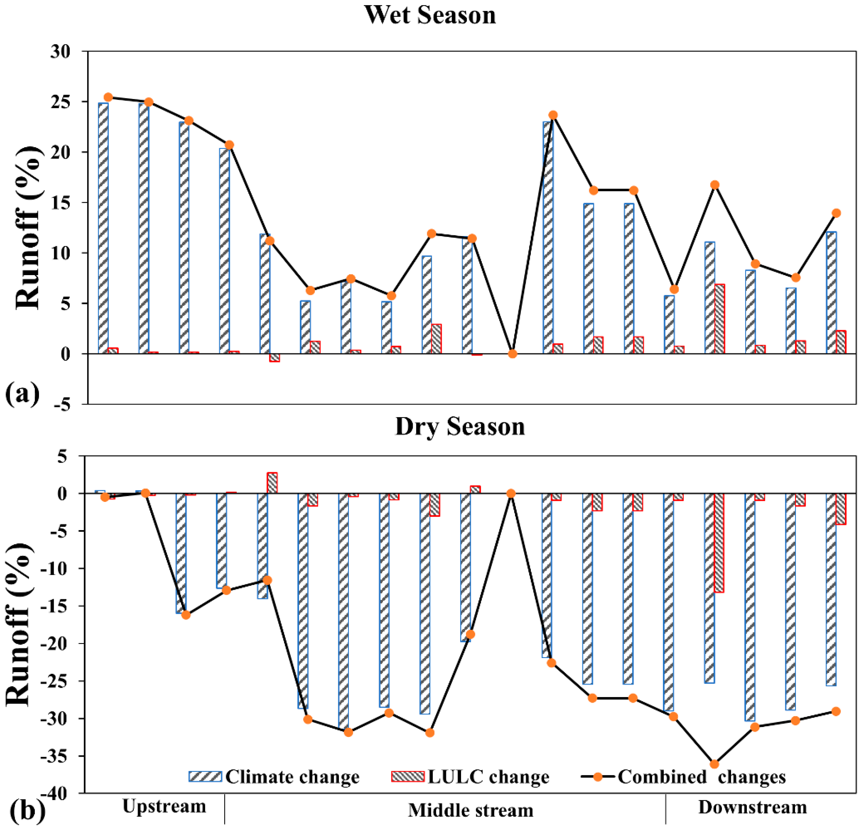
The land use changes analysis also shows a similar increasing and decreasing runoff trend in the wet and dry seasons, respectively. Unlike climate change, land use changes on runoff are minimal, increasing by about 7% and decreasing by −13.16% in the wet and dry seasons, respectively. This increase and decrease in runoff could be associated with the development of agricultural and urban areas at the expense of forest land, shown in
Figure 3b. Expanding cultivation can lead to a decline in soil water content, surface coarseness [
91], and increases the basin’s tendency to high runoffs [
92]. A similar result was shown with an incline in runoff in the Rokel-Seli River due to mining, dam expansion, and agricultural activities at the expense of forest land [
37]. The LULC changes revealed a decrease in forest land and an increase in other land use types, due to the expansion and rehabilitation of the major reservoir for the Bumbuna hydroelectric supply dam and human activities. Intensive cultivation can reduce the tendency of canopy cover and interrupt precipitation [
92]. They affect the land use and the general ecosystem in various aspects. While our findings focus on the period from 1965 to 2016, maintaining consistent data overlaps between the response of land use and climate datasets, the 2013 LULC map tends to be a more suitable match. We do recognize that likely greater human pressure might have been exhibited between 2017 and 2026. Therefore, this research would serve as a foundational attribution analysis required in the data-limited RSRB. In the study, allowing a balance in the 25-year comparison of the baseline (1988 LULC), we chose the 2013 LULC as the recent epoch. However, the study is a controlled experiment; changing one data point breaks the whole grid from S
1 through S
4. A study by [
93] showed a decrease in forest land and water bodies and an increase in urban and agricultural activities, which is related to our study. Therefore, if adequate measures are not taken by the Government of Sierra Leone, youths and stakeholders, these communities might lead to more environmental hazards in the future. Providing infiltration basins that preserve surface runoff water, which can boost baseflow by slowly seeping into the RSRB during the dry season, is recommended.
The combined land use and climate changes greatly influence seasonal runoff variations in the RSRB (
Figure 10). It reveals a similar runoff outcome to that of climate change, with an increasing and a decreasing pattern in the wet and dry seasons, respectively. The decrease is mainly concentrated in the middle and downstream of the basin. Runoff ranges from −36 to 0.8% in the dry season and in the wet season from 5 to 25%. Increasing runoff tends to intensify the deposition of sediment, nitrate and phosphorus downstream of basins [
40], negatively affecting these areas. Despite this, its increase can be beneficial for fishing practices and aquatic environments [
40]. To adapt to runoff alterations in the RSRB, the use of water management and planning mechanisms should be practiced. The implementation of sediment traps in mining sites helps reduce runoff in mining areas. The RSRB seasonal streamflow variations suggest a vulnerable water balance, which may significantly fluctuate water availability. The findings offer a reference framework for water resources authorities and stakeholders to develop water conservation and land management policies. This study establishes an essential datum for future water resource management systems that will tend to incorporate current observed data with infrastructural practices. Such a study can also be beneficial for monitoring and modeling ecological changes in other regions, thereby enhancing decision-makers’ knowledge in allocating strategic plans for the natural ecosystem and water sustainability [
94].
Our study highlights limitations to be considered in future studies. Future studies in the basin could consider socioeconomic and spatial variables such as gross domestic product (GDP), economic and technological advancement, political economy and climatic variables, and explore LULC and climate changes, using various scenarios. Coupling the CA-ANN model to simulate and predict future LULC maps and examine the hydrological regime is essential. This study’s SWAT modelling simulation primarily characterised the naturalized flow conditions of the Rokel-Seli River Basin. Because of unavailable operational datasets and to maintain focus on the drivers of change on climate and land use variability, the Bumbuna Dam operations were not modeled. However, this study provides a rudimentary assessment framework for regional policy makers, despite the limitations of using historical datasets and the omission of Bumbuna Dam operations. This study technique aligns with future regional modeling and land use change assessment by [
45]. Future studies should consider the most recent meteorological, streamflow and water quality data and employed in the SWAT + model when they become available for in-depth climate and LULC changes assessment. Our study only used GFDL-ESM2M data from the ISIMIP dataset of CMIP 5; future studies should incorporate various datasets, such as the MIROC5, NorESM1-M, HadGEM2-ES, and the CORDEX Africa and the CMIP 6 datasets. While a high-quality historical baseline was provided by the 1970s data, we know that the subsequent land use variations over the years might have affected the stationarity of these conditions; thus, the ability of the model to capture the RSRB response remains statistically significant. Despite these limitations, this study’s concise results and conclusions were based on the efficacy of a scenario simulation with a calibrated SWAT model.
5. Conclusions
This study examined the individual and the combined changes in climate and LULC on runoff in the RSRB hydrology using scenario simulation with the SWAT model from 1965 to 2016. The LULC maps of 1988 and 2013 were produced using the ENVI 5.3 software, corresponding to GCM’s data from 1965 to 1990 and 1991 to 2016, respectively. Four scenarios were considered to evaluate the variations. Between 1988 and 2013, respectively, urban, bare and agricultural land increased at the expense of forest land (14.75%). Overall, the LULC changes revealed a decrease in forest land from 1988 to 2013 in the RSRB.
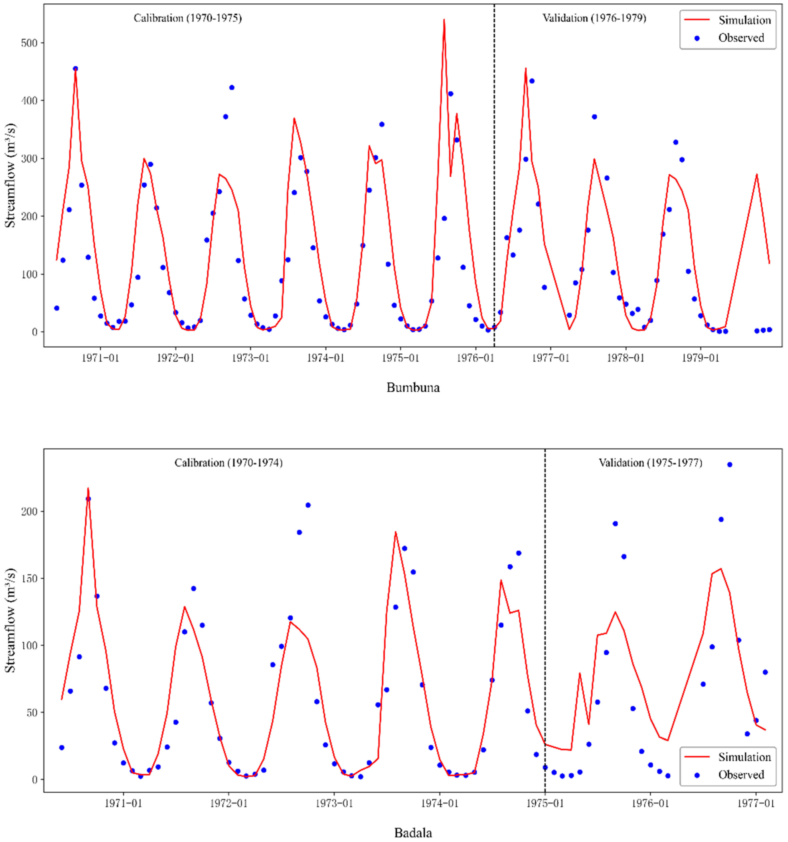
The simulated runoff by the SWAT model compared with observed streamflow data by the SWAT-CUP calibration and validation process. The SWAT model’s outcomes indicated statistical indicators of R2 (0.6–0.78), NSE (0.5–0.78), PBias (±25%) and KGE (55–85%), revealing its ability to simulate the RSRB hydrological cycle under a changing environment. Overall, a satisfactory agreement was shown between the simulated and observed data in the calibrated results.
Forest land decrease led to a seasonal increase and decrease in runoff, with a range of −31 to 25% under climate change and −14 to 7% for LULC change. The research’s major finding is that climate change runoff triggered the RSRB runoff variations significantly compared with LULC changes. This research methodology could serve as a datum, which can be replicated in other data-sparse regions globally.
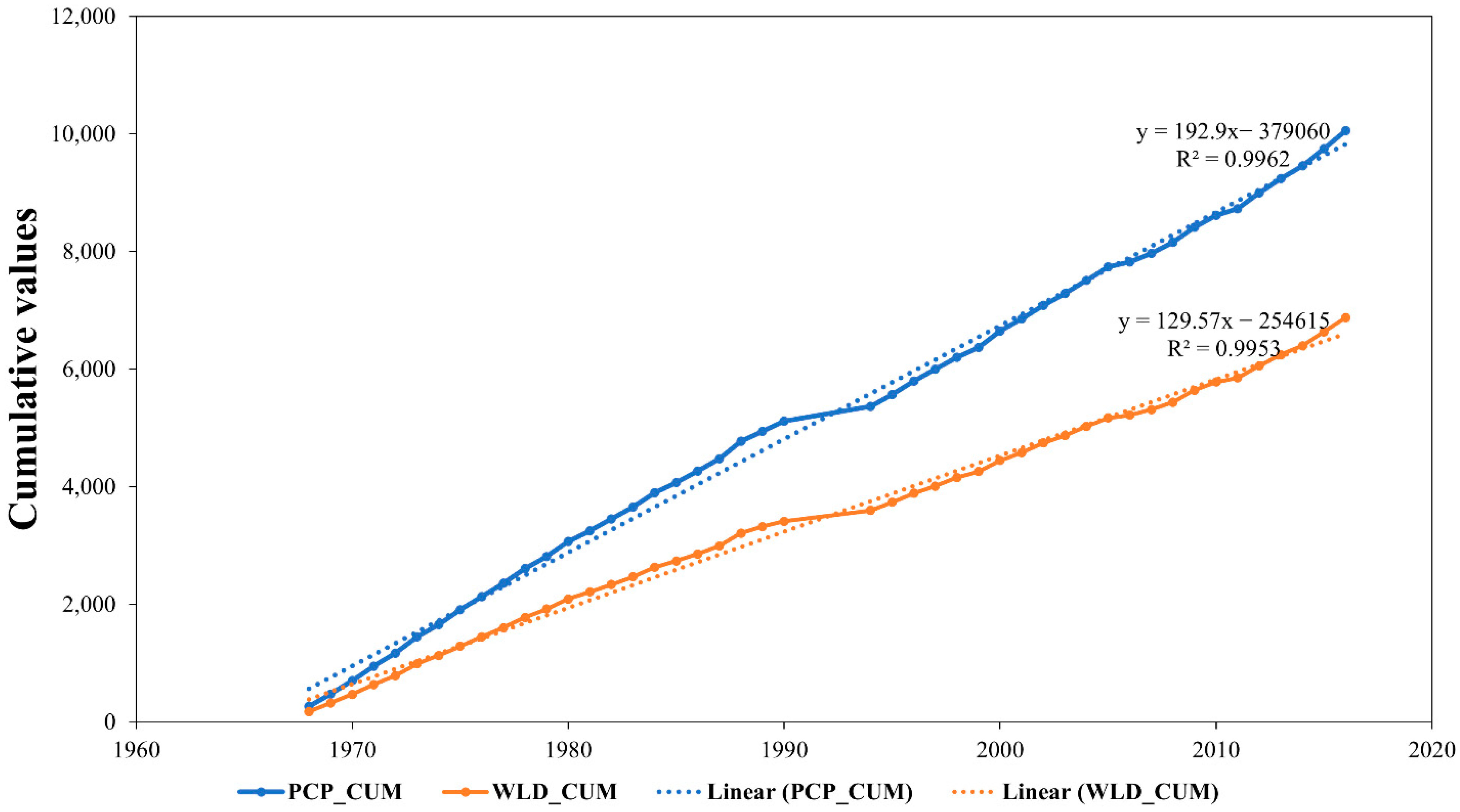
Based on the comparative analysis performed for both the historical and present periods, a substantial shift in the hydrological regime was observed. An increase in the runoff coefficient (K) of 0.67 to 0.69 was revealed, which represents an increase in runoff generation efficiency of 2.78%. The slope of the DMC increasing trend offers strong evidence of the intensification of land use effects statistically. Overall, the results suggest that the basin’s retention ability has been compromised by the land use anthropogenic effects, resulting in a flashier hydrological impact, wherein priority is given to the wet season runoff at the detriment of the sustainability of the dry season baseflow.
Additionally, a new insight from the attribution analysis shows that transitioning from 1988 to 2013 conditions increases runoff efficiency in the basin due to the anthropogenic land changes. This effectively serves as a hydrological buffer that conceals the complete adversity of the water deficit caused by climate change. The runoff coefficient of variation (Cv) increases by 1.12, indicating a higher possibility of flash flood, which could cause hydrological instability in the basin.
In conclusion, the evidence of the hydrological regime shifts suggests that the establishment of strategic policies focusing on sustainable urbanization and forest conservation, aiming to limit the potential threats of water scarcity in the RSRB, is indispensable. Future studies should attempt to predict sediment deposits and lateral flow in the basin. Since the retention ability of the basin has been compromised, subsequent human activities must abide by regulations that prioritize reforestation and green infrastructure. By quantifying the separate and the combined impact of land use and climate change, this study’s quantitative insight is crucial for water planners in designing climate-resilient infrastructures in the RSRB, specifically to resist the dual human and environmental pressures. Establishing and implementing riparian buffers and no-go areas for mining areas are essential hydrological requirements that help curtail the accelerating volatility of the RSRB water cycle.




 ,
,