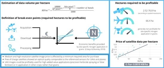
Economic Comparison of Satellite, Plane and UAV-Acquired NDVI Images for Site-Specific Nitrogen Application: Observations from Italy
Abstract
:1. Introduction
1.1. Satellite
1.2. Planes
1.3. Unmanned Aerial Vehicles (UAV)
2. Materials and Methods
2.1. Dataset Composition
2.2. Spectral Accuracy of NDVI and Quality Comparison
2.3. Price Composition, Modelization and Profitability Analysis
3. Results and Discussion
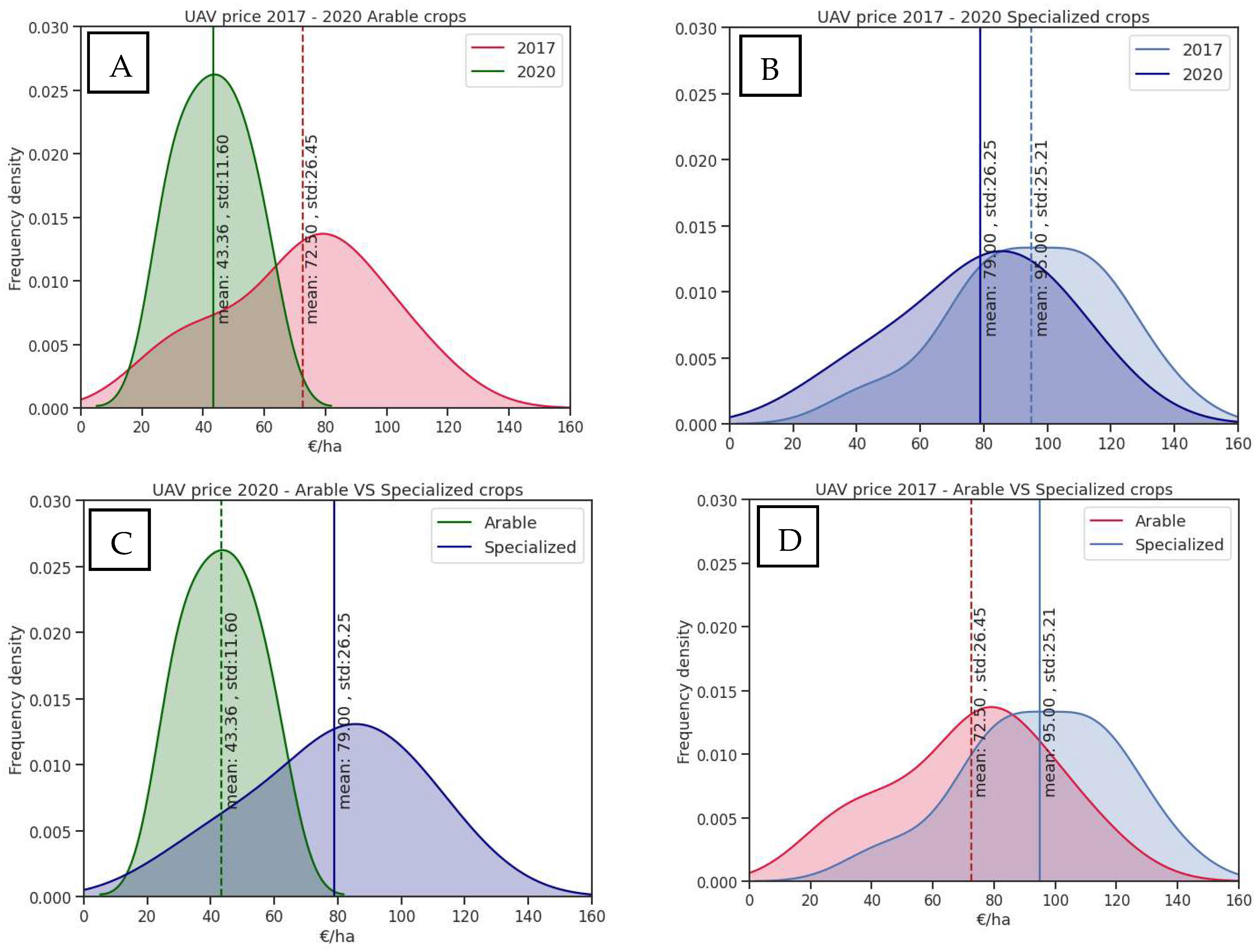
3.1. UAV Prices Analysis
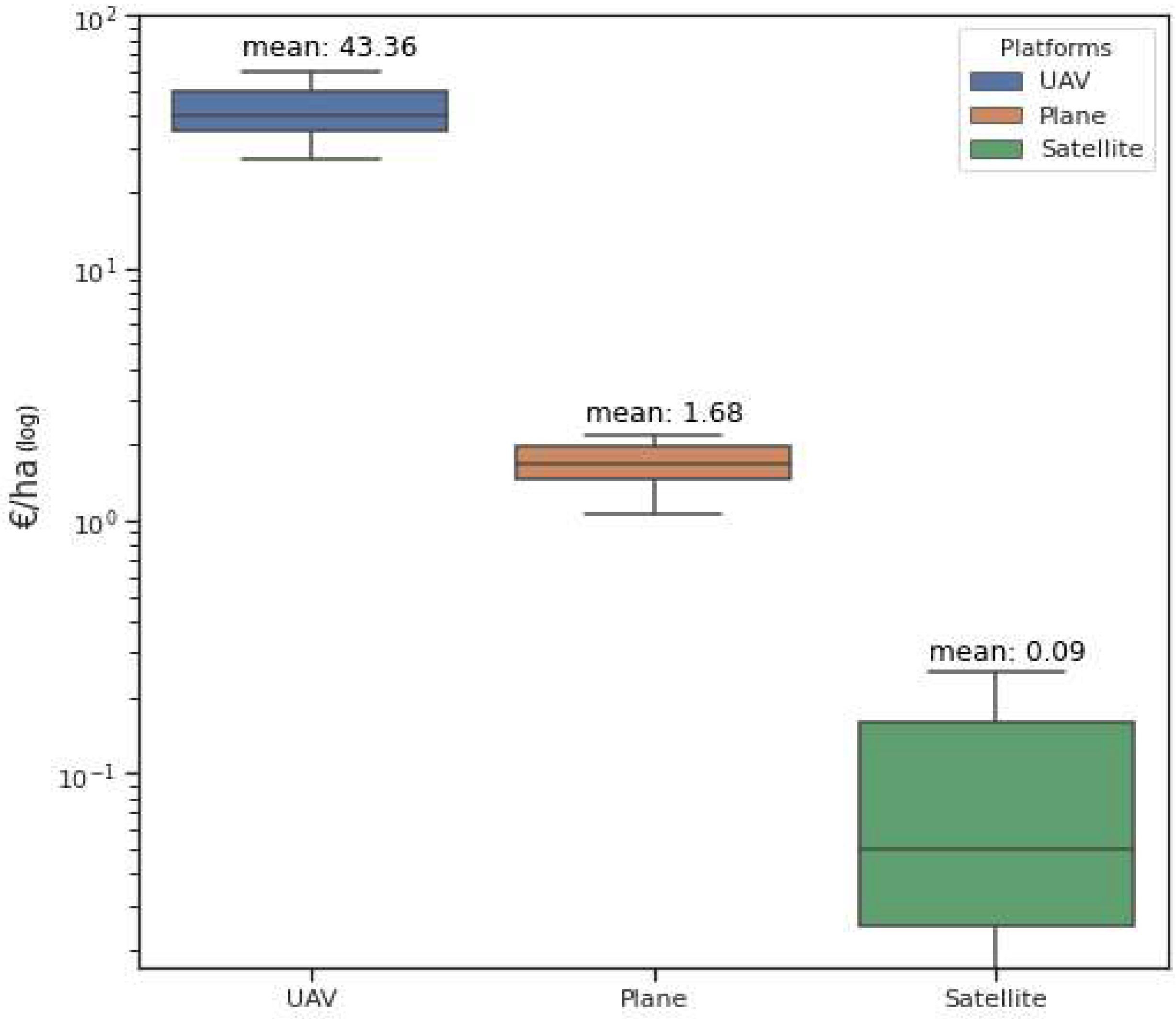
3.2. Raw Image Price per Hectare Comparison
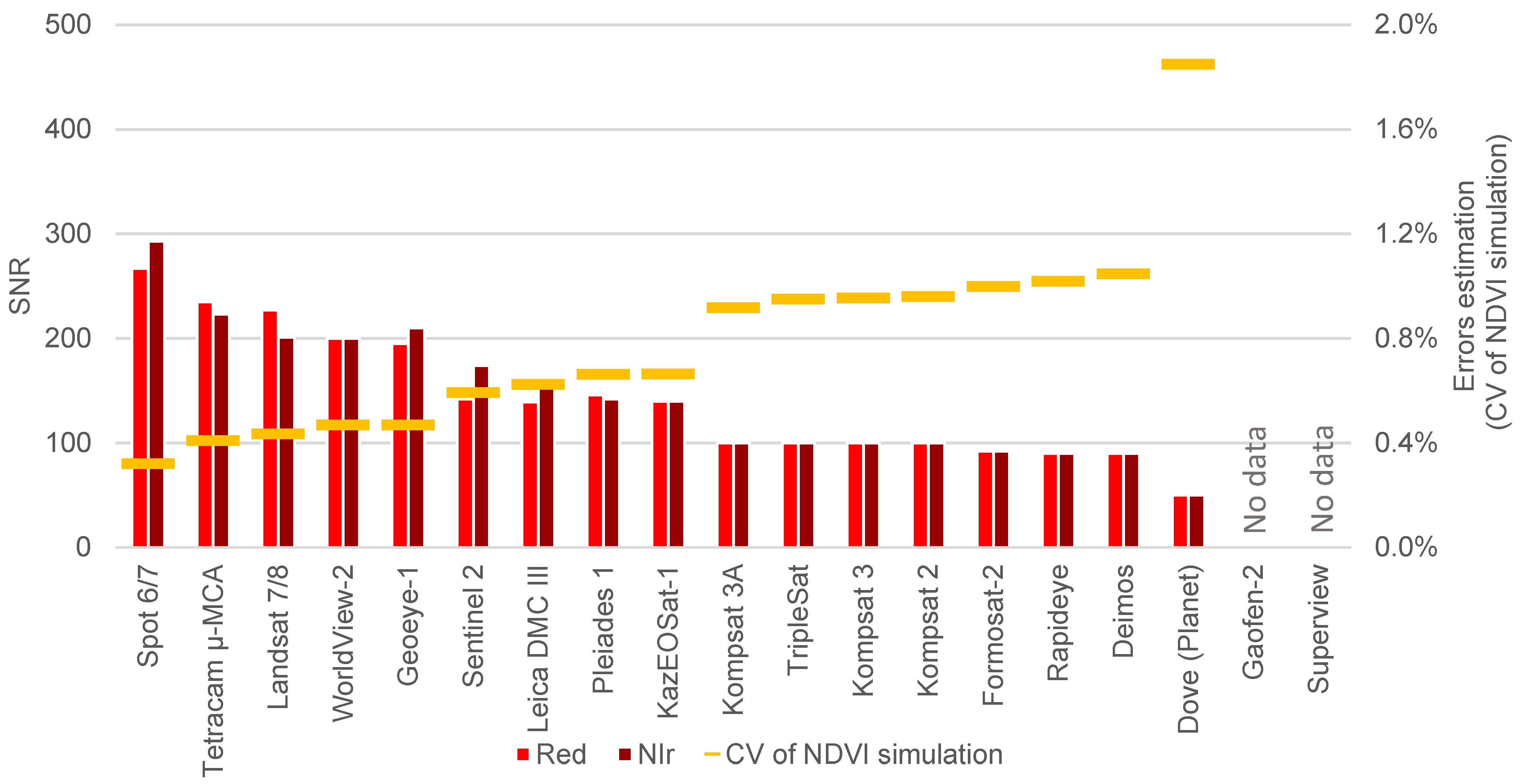
3.3. Sensors Quality Evaluation
3.4. Satellite Image Price Modeling
3.5. Variable Rate Nitrogen Application Profitability
4. Conclusions
Author Contributions
Funding
Data Availability Statement
Acknowledgments
Conflicts of Interest
References
- Fountas, S.; Aggelopoulou, K.; Gemtos, T.A. Precision agriculture. In Supply Chain Management for Sustainable Food Networks; John Wiley & Sons, Ltd.: Chichester, UK, 2016; pp. 41–65. ISBN 9781118937495. [Google Scholar]
- Shaddad, S.M.; Madrau, S.; Castrignanò, A.; Mouazen, A.M. Data fusion techniques for delineation of site-specific management zones in a field in UK. Precis. Agric. 2016, 17, 200–217. [Google Scholar] [CrossRef]
- Martínez-Casasnovas, J.; Escolà, A.; Arnó, J. Use of farmer knowledge in the delineation of potential management zones in precision agriculture: A case study in maize (Zea mays L.). Agriculture 2018, 8, 84. [Google Scholar] [CrossRef] [Green Version]
- De Benedetto, D.; Castrignano, A.; Diacono, M.; Rinaldi, M.; Ruggieri, S.; Tamborrino, R. Field partition by proximal and remote sensing data fusion. Biosyst. Eng. 2013, 114, 372–383. [Google Scholar] [CrossRef]
- Viscarra Rossel, R.A.; Adamchuk, V.I. Proximal soil sensing. Vadose Zo. J. 2011, 10, 1340. [Google Scholar]
- Madugundu, R.; Al-Gaadi, K.A.; Tola, E.; Kayad, A.G.; Hassaballa, A.A.; Patil, V.C. Seasonal dynamics of surface energy fluxes over a center-pivot irrigated cropland in Saudi Arabia. J. Environ. Biol. 2017, 38, 743–751. [Google Scholar] [CrossRef]
- Cillis, D.; Maestrini, B.; Pezzuolo, A.; Marinello, F.; Sartori, L. Modeling soil organic carbon and carbon dioxide emissions in different tillage systems supported by precision agriculture technologies under current climatic conditions. Soil Tillage Res. 2018, 183, 51–59. [Google Scholar] [CrossRef]
- Padilla, F.M.; Gallardo, M.; Peña-Fleitas, M.T.; de Souza, R.; Thompson, R.B. Proximal optical sensors for nitrogen management of vegetable crops: A review. Sensors 2018, 18, 2083. [Google Scholar] [CrossRef] [PubMed] [Green Version]
- Viscarra Rossel, R.A.; McBratney, A.B.; Minasny, B. Proximal Soil Sensing; Springer: New York, NY, USA, 2010; ISBN 9048188598. [Google Scholar]
- Jin, X.; Li, Z.; Yang, G.; Yang, H.; Feng, H.; Xu, X.; Wang, J.; Li, X.; Luo, J. Winter wheat yield estimation based on multi-source medium resolution optical and radar imaging data and the AquaCrop model using the particle swarm optimization algorithm. ISPRS J. Photogramm. Remote Sens. 2017, 126, 24–37. [Google Scholar] [CrossRef]
- Rouse, J.W.; Hass, R.H.; Schell, J.A.; Deering, D.W. Monitoring vegetation systems in the great plains with ERTS. In Third Earth Resources Technology Satellite-1 Symposium: The Proceedings of a Symposium Held by Goddard Space Flight Center at Washington, DC on 10–14 December 1973: Prepared at Goddard Space Flight Center (Vol. 351); Scientific and Technical Information Office, National Aeronautics and Space Administration.: Washington, DC, USA, 1974; Volume 1, pp. 309–317. [Google Scholar]
- Novelli, F.; Spiegel, H.; Sandén, T.; Vuolo, F.; Novelli, F.; Spiegel, H.; Sandén, T.; Vuolo, F. Assimilation of Sentinel-2 leaf area index data into a physically-based crop growth model for yield estimation. Agronomy 2019, 9, 255. [Google Scholar] [CrossRef] [Green Version]
- Kayad, A.; Sozzi, M.; Gatto, S.; Whelan, B.; Sartori, L.; Marinello, F. Ten years of corn yield dynamics at field scale under digital agriculture solutions: A case study from North Italy. Comput. Electron. Agric. 2021, 185, 106126. [Google Scholar] [CrossRef]
- Cogato, A.; Pezzuolo, A.; Sørensen, C.G.; De Bei, R.; Sozzi, M.; Marinello, F. A GIS-based multicriteria index to evaluate the mechanisability potential of Italian vineyard area. Land 2020, 9, 469. [Google Scholar] [CrossRef]
- Sarvia, F.; Xausa, E.; Petris, S.D.; Cantamessa, G.; Borgogno-Mondino, E. A possible role of copernicus Sentinel-2 data to support common agricultural policy controls in agriculture. Agronomy 2021, 11, 110. [Google Scholar] [CrossRef]
- Cogato, A.; Meggio, F.; Collins, C.; Marinello, F. Medium-resolution multispectral data from Sentinel-2 to assess the damage and the recovery time of late frost on vineyards. Remote Sens. 2020, 12, 1896. [Google Scholar] [CrossRef]
- Sozzi, M.; Kayad, A.; Tomasi, D.; Lovat, L.; Marinello, F.; Sartori, L. Assessment of grapevine yield and quality using a canopy spectral index in white grape variety. In Proceedings of the Precision Agriculture 2019—Papers Presented at the 12th European Conference on Precision Agriculture, ECPA 2019, Montpellier, France, 8–11 July 2019; pp. 181–186. [Google Scholar]
- Ma, B.L.; Morrison, M.J.; Dwyer, L.M. Canopy light reflectance and field greenness to assess nitrogen fertilization and yield of maize. Agron. J. 1996, 88, 915–920. [Google Scholar] [CrossRef]
- Raun, W.R.; Solie, J.B.; Johnson, G.V.; Stone, M.L.; Lukina, E.V.; Thomason, W.E.; Schepers, J.S. In-season prediction of potential grain yield in winter wheat using canopy reflectance. Agron. J. 2001, 93, 131. [Google Scholar] [CrossRef] [Green Version]
- Raun, W.R.; Solie, J.B.; Stone, M.L.; Martin, K.L.; Freeman, K.W.; Mullen, R.W.; Zhang, H.; Schepers, J.S.; Johnson, G.V. Optical sensor-based algorithm for crop nitrogen fertilization. Commun. Soil Sci. Plant Anal. 2005, 36, 2759–2781. [Google Scholar] [CrossRef] [Green Version]
- Thomason, W.E.; Phillips, S.B.; Davis, P.H.; Warren, J.G.; Alley, M.M.; Reiter, M.S. Variable nitrogen rate determination from plant spectral reflectance in soft red winter wheat. Precis. Agric. 2011, 12, 666–681. [Google Scholar] [CrossRef]
- Portz, G.; Molin, J.P.; Jasper, J. Active crop sensor to detect variability of nitrogen supply and biomass on sugarcane fields. Precis. Agric. 2012, 13, 33–44. [Google Scholar] [CrossRef]
- Arnall, D.B.; Abit, M.J.M.; Taylor, R.K.; Raun, W.R. Development of an NDVI-based nitrogen rate calculator for cotton. Crop Sci. 2016, 56, 3263. [Google Scholar] [CrossRef]
- Blondlot, A.; Gate, P.; Poilvé, H. Providing operational nitrogen recommendations to farmers using satellite imagery. In Proceedings of the Precision Agriculture 2005, ECPA 2005, Uppsala, Sweden, 9–12 June 2005; Volume 123, pp. 345–352. [Google Scholar]
- Shou, L.; Jia, L.; Cui, Z.; Chen, X.; Zhang, F. Using high-resolution satellite imaging to evaluate nitrogen status of winter wheat. J. Plant Nutr. 2007, 30, 1669–1680. [Google Scholar] [CrossRef]
- Huang, S.; Miao, Y.; Yuan, F.; Gnyp, M.; Yao, Y.; Cao, Q.; Wang, H.; Lenz-Wiedemann, V.; Bareth, G.; Huang, S.; et al. Potential of RapidEye and WorldView-2 satellite data for improving rice nitrogen status monitoring at different growth stages. Remote Sens. 2017, 9, 227. [Google Scholar] [CrossRef] [Green Version]
- Magney, T.S.; Eitel, J.U.H.; Vierling, L.A. Mapping wheat nitrogen uptake from RapidEye vegetation indices. Precis. Agric. 2017, 18, 429–451. [Google Scholar] [CrossRef]
- Lundström, C.; Lindblom, J. Considering farmers’ situated knowledge of using agricultural decision support systems (AgriDSS) to Foster farming practices: The case of CropSAT. Agric. Syst. 2018, 159, 9–20. [Google Scholar] [CrossRef]
- Georgi, C.; Spengler, D.; Itzerott, S.; Kleinschmit, B. Automatic delineation algorithm for site-specific management zones based on satellite remote sensing data. Precis. Agric. 2018, 19, 684–707. [Google Scholar] [CrossRef] [Green Version]
- Stamatiadis, S.; Schepers, J.S.; Evangelou, E.; Glampedakis, A.; Glampedakis, M.; Dercas, N.; Tsadilas, C.; Tserlikakis, N.; Tsadila, E. Variable-rate application of high spatial resolution can improve cotton N-use efficiency and profitability. Precis. Agric. 2019, 21, 695–712. [Google Scholar] [CrossRef]
- Yuan, L.; Pu, R.; Zhang, J.; Wang, J.; Yang, H. Using high spatial resolution satellite imagery for mapping powdery mildew at a regional scale. Precis. Agric. 2016, 17, 332–348. [Google Scholar] [CrossRef]
- Houborg, R.; McCabe, M.; Houborg, R.; McCabe, M.F. High-resolution NDVI from planet’s constellation of earth observing nano-satellites: A new data source for precision agriculture. Remote Sens. 2016, 8, 768. [Google Scholar] [CrossRef] [Green Version]
- Marinello, F.; Bramley, R.G.V.; Cohen, Y.; Fountas, S.; Guo, H.; Karkee, M.; Martínez-Casasnovas, J.A.; Paraforos, D.S.; Sartori, L.; Sorensen, C.G.; et al. Agriculture and digital sustainability: A digitization footprint. In Proceedings of the Precision Agriculture ’19, Montpellier, France, 8–11 July 2019; Wageningen Academic Publishers: Wageningen, The Netherlands, 2019; pp. 83–89. [Google Scholar]
- Ryu, C.; Suguri, M.; Umeda, M. Model for predicting the nitrogen content of rice at panicle initiation stage using data from airborne hyperspectral remote sensing. Biosyst. Eng. 2009, 104, 465–475. [Google Scholar] [CrossRef] [Green Version]
- Camino, C.; González-Dugo, V.; Hernández, P.; Sillero, J.C.; Zarco-Tejada, P.J. Improved nitrogen retrievals with airborne-derived fluorescence and plant traits quantified from VNIR-SWIR hyperspectral imagery in the context of precision agriculture. Int. J. Appl. Earth Obs. Geoinf. 2018, 70, 105–117. [Google Scholar] [CrossRef]
- Yang, C.; Everitt, J.H.; Bradford, J.M.; Escobar, D.E. Mapping grain sorghum growth and yield variations using airborne multispectral digital imagery. Trans. Am. Soc. Agric. Eng. 2000, 43, 1927–1938. [Google Scholar] [CrossRef]
- Yang, C.; Everitt, J.H.; Bradford, J.M. Comparison of QuickBird satellite imagery and airborne imagery for mapping grain sorghum yield patterns. Precis. Agric. 2006, 7, 33–44. [Google Scholar] [CrossRef]
- Mogili, U.R.; Deepak, B.B.V.L. Review on application of drone systems in precision agriculture. In Procedia Computer Science; Elsevier: Amsterdam, The Netherlands, 2018; Volume 133, pp. 502–509. [Google Scholar]
- Daponte, P.; De Vito, L.; Glielmo, L.; Iannelli, L.; Liuzza, D.; Picariello, F.; Silano, G. A review on the use of drones for precision agriculture. In IOP Conference Series: Earth and Environmental Science; IOPscience: Bristol, UK, 2019; Volume 275, p. 012022. [Google Scholar]
- Dubbini, M.; Pezzuolo, A.; De Giglio, M.; Gattelli, M.; Curzio, L.; Covi, D.; Yezekyan, T.; Marinello, F. Last generation instrument for agriculture multispectral data collection. Agric. Eng. Int. CIGR J. 2017, 19, 87–93. [Google Scholar]
- Sozzi, M.; Kayad, A.; Giora, D.; Sartori, L.; Marinello, F. Cost-effectiveness and performance of optical satellites constellation for Precision Agriculture. In Proceedings of the Precision Agriculture ’19, Montpellier, France, 8–11 July 2019; Wageningen Academic Publishers: Wageningen, The Netherlands, 2019; pp. 501–507. [Google Scholar]
- USDA. USDA Definition of Specialty Crop; USDA: Washington, DC, USA, 2016.
- Minařík, R.; Langhammer, J. Rapid radiometric calibration of multiple camera array using insitu data for UAV multispectral photogrammetry. In International Archives of the Photogrammetry, Remote Sensing and Spatial Information Sciences—ISPRS Archives; ISPRS: Hannover, Germany, 2019; Volume 42, pp. 209–215. [Google Scholar]
- Leica Geosystems AG. Leica DMC III Product Specifications; Leica Geosystems: Heerbrugg, Switzerland, 2017. [Google Scholar]
- Mulla, D.J. Twenty five years of remote sensing in precision agriculture: Key advances and remaining knowledge gaps. Biosyst. Eng. 2013, 114, 358–371. [Google Scholar] [CrossRef]
- Anderson, G.M. Error propagation by the Monte Carlo method in geochemical calculations. Geochim. Cosmochim. Acta 1976, 40, 1533–1538. [Google Scholar] [CrossRef]
- Hartigan, J.A.; Wong, M.A. Algorithm AS 136: A K-means clustering algorithm. Appl. Stat. 1979, 28, 100. [Google Scholar] [CrossRef]
- Martínez-Álvarez, F.; Troncoso, A.; Riquelme, J.C.; Riquelme, J.M. Partitioning-clustering techniques applied to the electricity price time series. Lect. Notes Comput. Sci. 2007, 4881, 990–999. [Google Scholar] [CrossRef]
- Ma, C.; Liu, Z.; Cao, Z.; Song, W.; Zhang, J.; Zeng, W. Cost-sensitive deep forest for price prediction. Pattern Recognit. 2020, 107, 107499. [Google Scholar] [CrossRef]
- Empirica Gesellschaft für Kommunikations-und Technologieforschung mbH; TÜV Rheinland. Mobile Broadband Prices in Europe; Publications Office of the European Union: Luxembourg, 2019. [Google Scholar]
- Eurostat. Labour Cost, Wages and Salaries, Direct Remuneration (Excluding Apprentices) by NACE Rev. 2 Activity)—LCS Surveys 2008, 2012 and 2016; Eurostat: Luxembourg, 2016. [Google Scholar]
- Colaço, A.F.; Bramley, R.G.V. Do crop sensors promote improved nitrogen management in grain crops? Field Crops Res. 2018, 218, 126–140. [Google Scholar] [CrossRef]
- Breunig, F.M.; Galvão, L.S.; Dalagnol, R.; Santi, A.L.; Della Flora, D.P.; Chen, S. Assessing the effect of spatial resolution on the delineation of management zones for smallholder farming in southern Brazil. Remote Sens. Appl. Soc. Environ. 2020, 19. [Google Scholar] [CrossRef]
- Wu, M.; Yang, C.; Song, X.; Hoffmann, W.C.; Huang, W.; Niu, Z.; Wang, C.; Li, W.; Yu, B. Monitoring cotton root rot by synthetic Sentinel-2 NDVI time series using improved spatial and temporal data fusion. Sci. Rep. 2018, 8, 2016. [Google Scholar] [CrossRef] [PubMed] [Green Version]
- Guzinski, R.; Nieto, H.; Sandholt, I.; Karamitilios, G. Modelling high-resolution actual evapotranspiration through Sentinel-2 and Sentinel-3 data fusion. Remote Sens. 2020, 12, 1433. [Google Scholar] [CrossRef]
- Anger, J.; de Franchis, C.; Facciolo, G. Assessing the sharpness of satellite images: Study of the planetscope constellation. In Proceedings of the IGARSS 2019—2019 IEEE International Geoscience and Remote Sensing Symposium, Yokohama, Japan, 28 July–2 August 2019; pp. 389–392. [Google Scholar] [CrossRef] [Green Version]
- Sozzi, M.; Kayad, A.; Marinello, F.; Taylor, J.; Tisseyre, B. Comparing vineyard imagery acquired from Sentinel-2 and unmanned aerial vehicle (UAV) platform. OENO One 2020, 54, 189–197. [Google Scholar] [CrossRef] [Green Version]
- Yezekyan, T.; Benetti, M.; Armentano, G.; Trestini, S.; Sartori, L.; Marinello, F. Definition of reference models for power, mass, working width, and price for tillage implements. Agriculture 2021, 11, 197. [Google Scholar] [CrossRef]
- Stamatiadis, S.; Schepers, J.S.; Evangelou, E.; Tsadilas, C.; Glampedakis, A.; Glampedakis, M.; Dercas, N.; Spyropoulos, N.; Dalezios, N.R.; Eskridge, K. Variable-rate nitrogen fertilization of winter wheat under high spatial resolution. Precis. Agric. 2018, 19, 570–587. [Google Scholar] [CrossRef]
- Ørum, J.E.; Kudsk, P.; Jensen, P.K. Economics of Site-Specific And Variable-Dose Herbicide Application; Springer: Cham, Switzerland, 2017; pp. 93–110. [Google Scholar]
- Farquharson, R.; Welsh, J. The Economics and Perspectives of Site Specific Irrigation Management in Australia; Springer: Cham, Switzerland, 2017; pp. 111–127. [Google Scholar]
- Gandorfer, M.; Meyer-Aurich, A. Economic Potential of Site-Specific Fertiliser Application and Harvest Management; Springer: Cham, Switzerland, 2017; pp. 79–92. [Google Scholar]
- Matese, A.; Toscano, P.; Di Gennaro, S.; Genesio, L.; Vaccari, F.; Primicerio, J.; Belli, C.; Zaldei, A.; Bianconi, R.; Gioli, B. Intercomparison of UAV, aircraft and satellite remote sensing platforms for precision viticulture. Remote Sens. 2015, 7, 2971–2990. [Google Scholar] [CrossRef] [Green Version]
- Sozzi, M.; Bernardi, E.; Kayad, A.; Marinello, F.; Boscaro, D.; Cogato, A.; Gasparini, F.; Tomasi, D. On-the-go variable rate fertilizer application on vineyard using a proximal spectral sensor. In Proceedings of the 2020 IEEE International Workshop on Metrology for Agriculture and Forestry (MetroAgriFor), Trento, Italy, 4–6 November 2020; pp. 343–347. [Google Scholar] [CrossRef]
- Roberts, R.K.; English, B.C.; Mahajanashetti, S.B. Evaluating the returns to variable rate nitrogen application. J. Agric. Appl. Econ. 2000, 32, 133–143. [Google Scholar] [CrossRef] [Green Version]
- Roberts, R.K.; Mahajanashetti, S.B.; English, B.C.; Larson, J.A.; Tyler, D.D. Variable rate nitrogen application on corn fields: The role of spatial variability and weather. J. Agric. Appl. Econ. 2002, 34, 111–129. [Google Scholar] [CrossRef] [Green Version]
- Basso, B.; Dumont, B.; Cammarano, D.; Pezzuolo, A.; Marinello, F.; Sartori, L. Environmental and economic benefits of variable rate nitrogen fertilization in a nitrate vulnerable zone. Sci. Total Environ. 2016, 545–546, 227–235. [Google Scholar] [CrossRef] [Green Version]


| Platform Name | Minimum Area | Price per Hectare | Data Volume per Hectare | Spatial Resolution * | Radiometic Resolution | Revisit Time | Data Source |
|---|---|---|---|---|---|---|---|
| ha min | EUR ha−1 ** | KB ha−1 *** | m | Bits Pixel−1 | Days | ||
| Deimos-2 | 10,000 | 0.055 | 12.7 | 0.75 | 10 | 2 | www.elecnor-deimos.com, accessed on 20 February 2019 |
| Dove (Planet) | 10,000 | 0.011 | 8.89 | 3 | 16 | 1 | www.planet.com, accessed on 20 February 2019 |
| Formosat-2 | 14,400 | 0.028 | 3.13 | 2 | 8 | 1 | www.nspo.narl.org.tw, accessed on 20 February 2019 |
| GaoFen-2 | 2500 | 0.041 | 34.2 | 0.8 | 14 | 5 | www.cast.cn, accessed on 20 February 2019 |
| GeoEye-1 | 10.000 | 0.250 | 102 | 0.5 | 11 | 3 | www.maxar.com, accessed on 5 July 2020 |
| KazEOSat-1 | 2500 | 0.057 | 6.25 | 3 | 12 | 1 | www.airbus.com, accessed on 5 July 2020 |
| Kompsat-2 | 2500 | 0.050 | 21.9 | 1 | 14 | 6 | www.kari.re.kr, accessed on 20 February 2019 |
| Kompsat-3 | 2500 | 0.100 | 44.6 | 0.7 | 14 | 3 | www.kari.re.kr, accessed on 20 February 2019 |
| Kompsat-3A | 2500 | 0.145 | 72.3 | 0.55 | 14 | 3 | www.kari.re.kr, accessed on 20 February 2019 |
| Landsat-7/8 | 3,700,000 | − | 0.203 | 15 | 12 | 8 | www.nasa.gov, accessed on 20 February 2019 |
| Pleiades-1 | 10,000 | 0.193 | 75.0 | 0.5 | 12 | 1 | www.airbus.com, accessed on 20 February 2019 |
| Rapideye | 10,000 | 0.011 | 3.00 | 5 | 12 | 5.5 | www.planet.com, accessed on 20 February 2019 |
| Sentinel-2 | 1,200,000 | − | 0.838 | 10 | 16 | 5 | www.esa.int, accessed on |
| Spot-6/7 | 10,000 | 0.041 | 8.33 | 1.5 | 12 | 1 | www.airbus.com, accessed on 20 February 2019 |
| Superview-1 | 10,000 | 0.227 | 68.8 | 0.5 | 11 | 4 | www.spaceview.com, accessed on 20 February 2019 |
| TripleSat | 2500 | 0.073 | 24.4 | 0.8 | 10 | 1 | www.earthi.space, accessed on 20 February 2019 |
| WorldView-3/4 | 10,000 | 0.250 | 179 | 0.3 | 11 | 1 | www.maxar.com, accessed on 20 February 2019 |
| Plane (Leica DMC III) | − | 1.68 | 9000 | 0.1 | 12 | − | www.leica-geosystems.com, accessed on 14 April 2020 |
| UAV (Tetracam µ-MCA) | − | 43.4 | 25,000 | 0.05 | 10 | − | www.tetracam.com, accessed on 14 April 2020 |
| UAV | PLANE | SATELLITE | |
|---|---|---|---|
| Dataset | 44 prices from 22 companies in 2017 22 prices from 11 companies in 2020 | Six prices from four companies | 62 prices from 17 constellation of satellites |
| Price and sensors features | -Price per hectare(€ ha−1) Reference sensor: Tetracam Micro-MCA [43] | -Price per hectare(EUR ha−1) -Take off cost Reference sensor: Leica DMC III [44] | Sensor properties used: -Price per hectare(EUR ha−1) -Minimum Area (ha) -Data Volume per Hectare (KB ha−1) |
| NDVI elaboration | Included in price per hectare | Included in price per hectare | Download cost: -Data Volume per Hectare (KB ha−1) -Price per Data Volume (EUR KB−1) [50] Correction cost: 150 (VHR)-100(HR)–50 (MR) EUR |
| Processing cost | 75 EUR | 75 EUR | 75 (VHR)/50(HR)/25(MR) EUR |
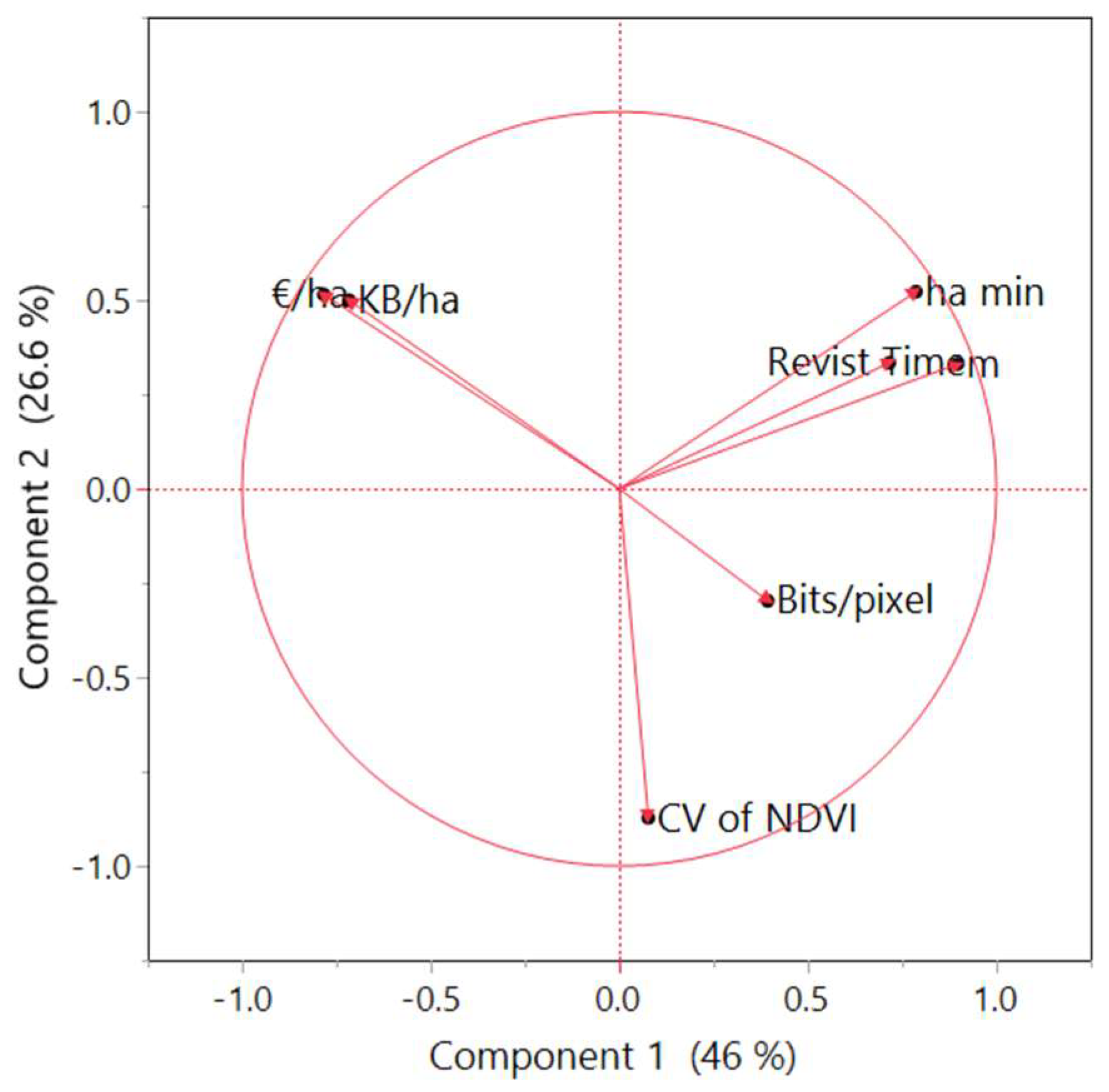
| Price per Hectare | Data Volume per Hectare | Spatial Resolution | Radiometic Resolution | Revisit Time | CV of NDVI | |
|---|---|---|---|---|---|---|
| EUR min | KB ha−1 | m | Bits Pixel−1 | Days | ||
| MR | 76.1 | 0.52 | 12.5 | 14.0 | 6.50 | 0.501% |
| HR | 434 | 21.8 | 1.55 | 12.4 | 3.14 | 0.737% |
| VHR | 2527 | 106 | 0.45 | 11.3 | 2.25 | 0.579% |
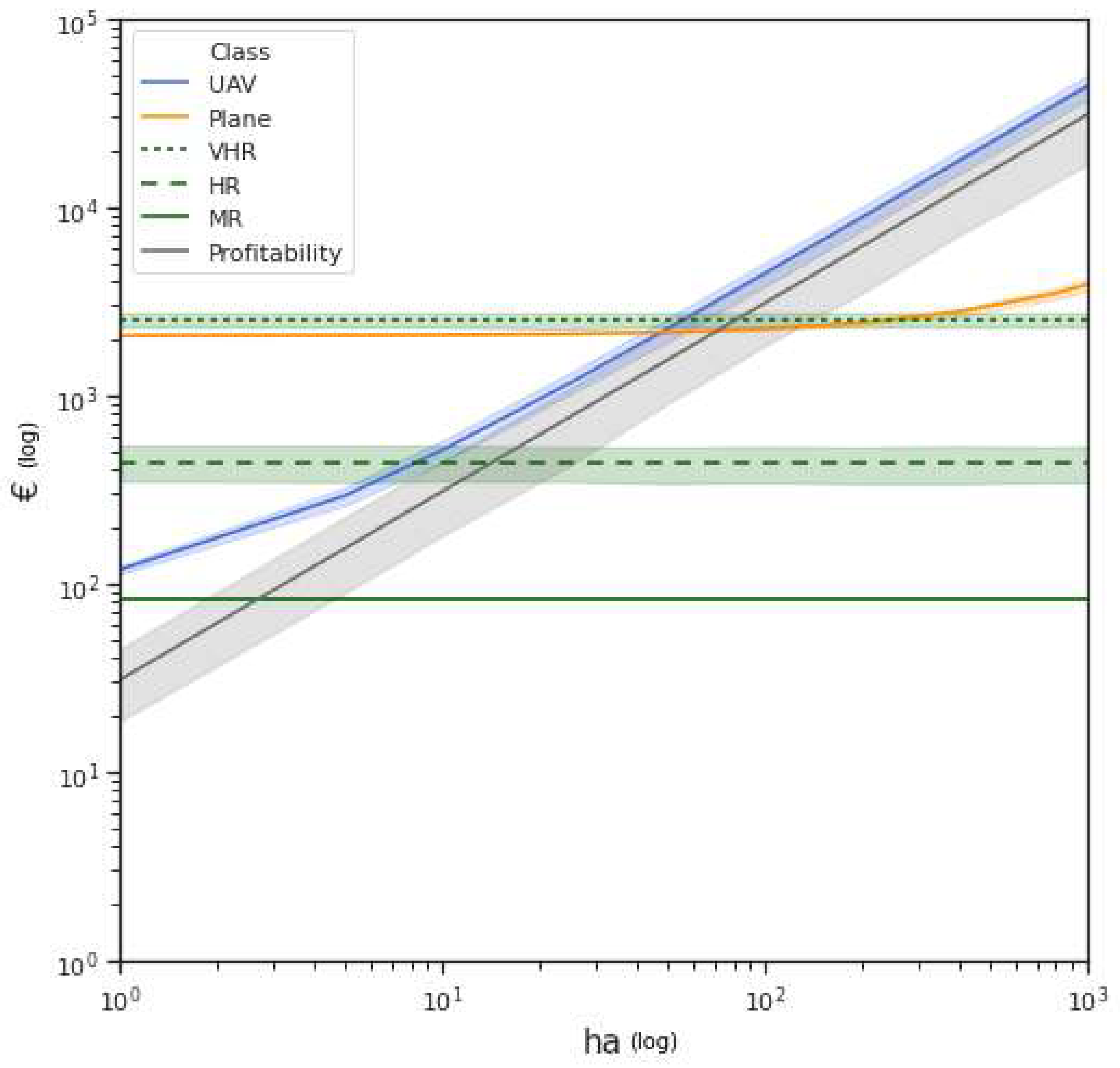
| Services | Equations |
|---|---|
| UAV | |
| Plane | . |
| VHR | |
| HR | |
| MR | |
| Profitability |
| Break-Even Points | ||
|---|---|---|
| Sensors | Hectares | EUR |
| MR | 2.52 | 83.1 |
| HR | 13.2 | 434 |
| Plane | 66.4 | 2191 |
| VHR | 76.8 | 2536 |
| UAV | n/a | n/a |
Publisher’s Note: MDPI stays neutral with regard to jurisdictional claims in published maps and institutional affiliations. |
© 2021 by the authors. Licensee MDPI, Basel, Switzerland. This article is an open access article distributed under the terms and conditions of the Creative Commons Attribution (CC BY) license (https://creativecommons.org/licenses/by/4.0/).
Share and Cite
Sozzi, M.; Kayad, A.; Gobbo, S.; Cogato, A.; Sartori, L.; Marinello, F. Economic Comparison of Satellite, Plane and UAV-Acquired NDVI Images for Site-Specific Nitrogen Application: Observations from Italy. Agronomy 2021, 11, 2098. https://doi.org/10.3390/agronomy11112098
Sozzi M, Kayad A, Gobbo S, Cogato A, Sartori L, Marinello F. Economic Comparison of Satellite, Plane and UAV-Acquired NDVI Images for Site-Specific Nitrogen Application: Observations from Italy. Agronomy. 2021; 11(11):2098. https://doi.org/10.3390/agronomy11112098
Chicago/Turabian StyleSozzi, Marco, Ahmed Kayad, Stefano Gobbo, Alessia Cogato, Luigi Sartori, and Francesco Marinello. 2021. "Economic Comparison of Satellite, Plane and UAV-Acquired NDVI Images for Site-Specific Nitrogen Application: Observations from Italy" Agronomy 11, no. 11: 2098. https://doi.org/10.3390/agronomy11112098
APA StyleSozzi, M., Kayad, A., Gobbo, S., Cogato, A., Sartori, L., & Marinello, F. (2021). Economic Comparison of Satellite, Plane and UAV-Acquired NDVI Images for Site-Specific Nitrogen Application: Observations from Italy. Agronomy, 11(11), 2098. https://doi.org/10.3390/agronomy11112098


