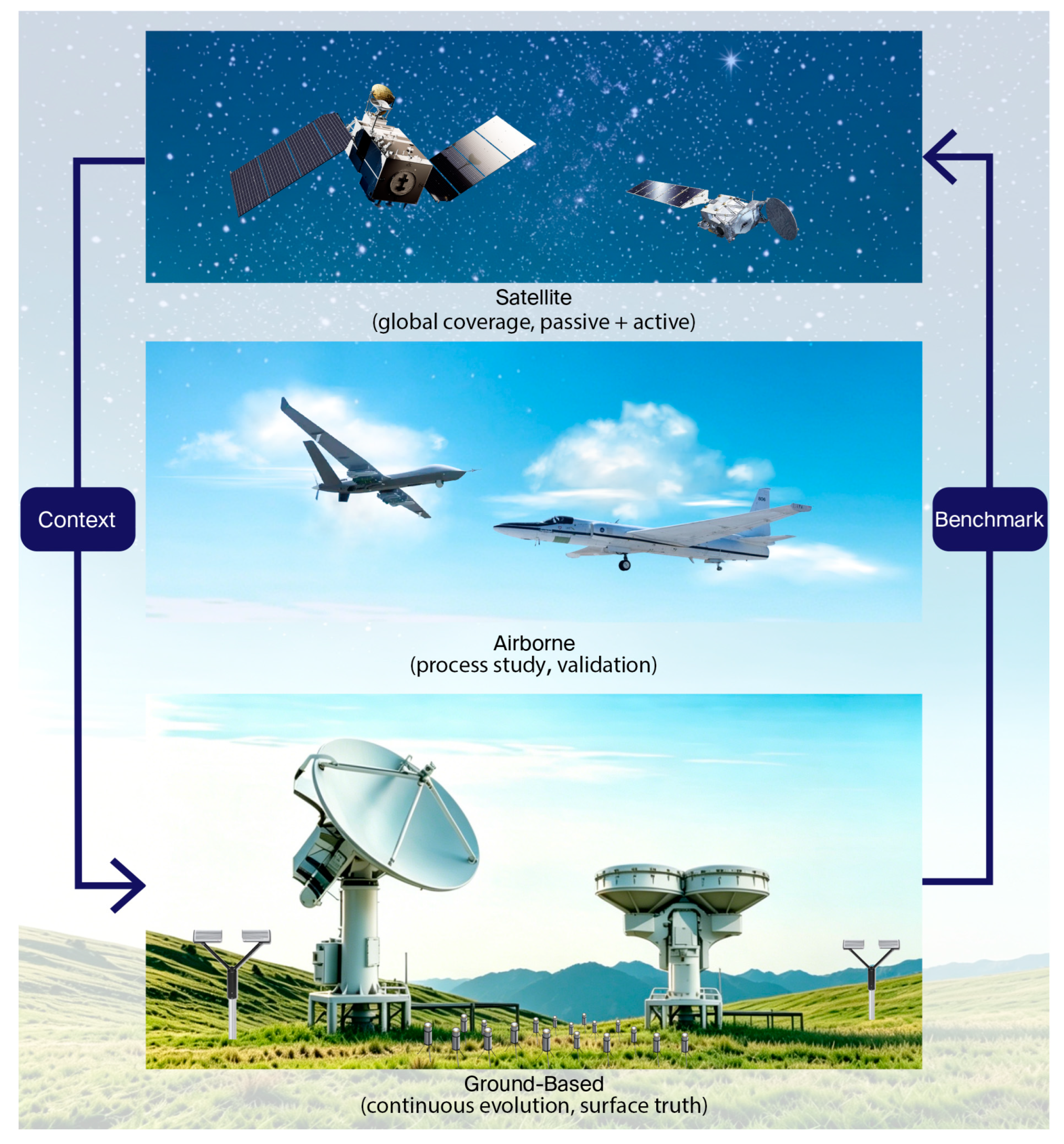
Recent Progress in Remote Sensing of Clouds and Precipitation Physics: Platforms, Applications, and Emerging Frontiers



Highlights
- Development and coordination of multi-platform remote sensing observation system.
- Evolution of remote sensing retrieval methods for clouds and precipitation characteristics.
- Remote sensing characterization capability of clouds and precipitation formation mechanism.
- The integrated multi-platform remote sensing framework improves the observation capability of clouds and precipitation.
- Advanced retrieval methods provide more accurate characterization of clouds and precipitation.
- Enhanced remote sensing capabilities contribute to better understanding of cloud–precipitation processes and formation mechanisms.
Abstract
1. Introduction
2. Remote Sensing Platforms and Instruments
2.1. Satellite Remote Sensing
2.2. Airborne Remote Sensing
2.3. Ground-Based Remote Sensing
2.4. Space–Air–Ground Integration
3. Remote Sensing of Cloud and Precipitation Characteristics
3.1. Cloud Optical Thickness, Effective Radius, and Phase
3.2. Liquid/Ice Water Content and Vertical Hydrometeor Structure
3.3. Precipitation Rate, Particle Size Distribution, and Near-Surface Constraints
4. Remote Sensing of Cloud and Precipitation Processes
4.1. Cloud Vertical Structure, Entrainment, and Mixed-Phase Evolution
4.2. Precipitation Initiation and Hydrometeor Growth Pathways
4.3. Extreme Weather, Model Evaluation, and Climate Applications
5. Challenges and Frontiers
5.1. Current Challenges
5.1.1. Uncertainties in Microphysical Parameter Retrieval Algorithms
5.1.2. Intrinsic Limitations of Sensors and Physical Constraints
5.1.3. Observation Bottlenecks in Complex Cloud-Precipitation Systems
5.1.4. Multi-Platform Data Synergy and Validation Challenges in Extreme Environments
5.2. Frontier Technologies
5.2.1. AI-Driven Intelligent Retrieval Technology
5.2.2. Space–Air–Ground Integrated Multi-Source Data Fusion Technology
5.2.3. Next-Generation Satellite Missions and Advanced Observation Payloads
5.2.4. Emerging Near-Ground Observation Technologies and Cross-Disciplinary Applications
6. Conclusions
Author Contributions
Funding
Data Availability Statement
Acknowledgments
Conflicts of Interest
References
- Zhou, R.; Dou, T.; Zhou, C.; Tan, I.; Chen, D.; Xu, G.; Yang, Y.; Gong, X.; Ju, X.; Wang, A.; et al. Observational constraints from global ice-phase fraction indicate moderate climate sensitivity. Sci. Adv. 2026, 12, eaea0731. [Google Scholar] [CrossRef] [Scilit] [PubMed]
- Levizzani, V.; Kidd, C. Clouds and Precipitation in the Earth System. In Precipitation; Geophysics and Environmental Physics; Springer: Cham, Switzerland, 2025; pp. 1–11. [Google Scholar]
- Freeman, S.; Brunner, K.; Jones, W.; Kukulies, J.; Senf, F.; Stier, P.; van den Heever, S. Advancing Our Understanding of Cloud Processes and Their Role in the Earth System through Cloud Object Tracking. Bull. Am. Meteorol. Soc. 2024, 105, E297–E299. [Google Scholar] [CrossRef] [Scilit]
- Dance, S.; Nichols, N. Improving Weather Forecasts Through Advanced Use of Observations. In More UK Success Stories in Industrial Mathematics; Mathematics in Industry; Aston, P.J., Ed.; Springer: Cham, Switzerland, 2025; Volume 42, pp. 9–15. [Google Scholar]
- Han, W.; Yin, R.; Li, J.; Liu, Y.; Wang, J.; Li, Y.; Qin, X.; Zhang, Z.; Shen, X. Targeted sounding observations from geostationary satellite and impacts on high impact weather forecasts. Sci. China Earth Sci. 2025, 68, 963–976. [Google Scholar] [CrossRef] [Scilit]
- Norris, J.R.; Allen, R.J.; Evan, A.T.; Zelinka, M.D.; O’dell, C.W.; Klein, S.A. Evidence for climate change in the satellite cloud record. Nature 2016, 536, 72–75. [Google Scholar] [CrossRef] [Scilit] [PubMed]
- Wu, Z.; Li, B.; Ge, H.; Yuan, L.; Liu, Y. Satellite-Based Remote Sensing of Atmospheric Water Vapor Over Oceans: An Inter-Comparison Against Shipborne GNSS Observations. IEEE Trans. Geosci. Remote Sens. 2024, 62, 4107308. [Google Scholar] [CrossRef] [Scilit]
- Yadav, K.; Malviya, S.; Tiwari, A.K. Improving Weather Forecasting in Remote Regions Through Machine Learning. Atmosphere 2025, 16, 587. [Google Scholar] [CrossRef] [Scilit]
- Su, J.; Miao, C.; Zwiers, F.; Beck, H.; Jones, P.; Sun, Q.; Slater, L.J.; Berghuijs, W.R.; Wada, Y.; Rosenfeld, D.; et al. Precipitation observing network gaps limit climate change impact assessment. Nature 2026, 652, 119–125. [Google Scholar] [CrossRef] [Scilit] [PubMed]
- Asutosh, A.; Chatterjee, S.; Subeesh, M.; Radhakrishnan, A.; Murukesh, N. Observation of Cloud Base Height and Precipitation Characteristics at a Polar Site Ny-Ålesund, Svalbard Using Ground-Based Remote Sensing and Model Reanalysis. Remote Sens. 2021, 13, 2808. [Google Scholar] [CrossRef] [Scilit]
- Wehr, T.; Kubota, T.; Tzeremes, G.; Wallace, K.; Nakatsuka, H.; Ohno, Y.; Koopman, R.; Rusli, S.; Kikuchi, M.; Eisinger, M.; et al. The EarthCARE mission–science and system overview. Atmos. Meas. Tech. 2023, 16, 3581–3620. [Google Scholar] [CrossRef] [Scilit]
- Levizzani, V.; Cattani, E. Satellite Remote Sensing of Precipitation and the Terrestrial Water Cycle in a Changing Climate. Remote Sens. 2019, 11, 2301. [Google Scholar] [CrossRef] [Scilit]
- Shang, H.; Hioki, S.; Penide, G.; Cornet, C.; Letu, H.; Riedi, J. Establishment of an analytical model for remote sensing of typical stratocumulus cloud profiles under various precipitation and entrainment conditions. Atmos. Chem. Phys. 2023, 23, 2729–2745. [Google Scholar] [CrossRef] [Scilit]
- Mason, S.; Hogan, R.; Bozzo, A.; Pounder, N. A unified synergistic retrieval of clouds, aerosols, and precipitation from EarthCARE: The ACM-CAP product. Atmos. Meas. Tech. 2023, 16, 3459–3482. [Google Scholar] [CrossRef] [Scilit]
- Li, J.; Zhang, F.; Li, W.; Tong, X.; Pan, B.; Li, J.; Lin, H.; Letu, H.; Mustafa, F. Transfer-Learning-Based Approach to Retrieve the Cloud Properties Using Diverse Remote Sensing Datasets. IEEE Trans. Geosci. Remote Sens. 2023, 61, 4106210. [Google Scholar] [CrossRef] [Scilit]
- Xiong, X.; Butler, J.J. MODIS and VIIRS Calibration History and Future Outlook. Remote Sens. 2020, 12, 2523. [Google Scholar] [CrossRef] [Scilit]
- Xiong, X.; Sun, J.; Angal, A.; Wilson, T. Calibration Inter-Comparison of MODIS and VIIRS Reflective Solar Bands Using Lunar Observations. Remote Sens. 2022, 14, 4754. [Google Scholar] [CrossRef] [Scilit]
- Kim, E.; Lyu, C.-H.J.; Anderson, K.; Leslie, R.V.; Blackwell, W.J. S-NPP ATMS instrument prelaunch and on-orbit performance evaluation. J. Geophys. Res. Atmos. 2014, 119, 5653–5670. [Google Scholar] [CrossRef] [Scilit]
- Holmlund, K.; Grandell, J.; Schmetz, J.; Stuhlmann, R.; Bojkov, B.; Munroand, R. Meteosat Third Generation (MTG): Continuation and Innovation of Observations from Geostationary Orbit. Bull. Am. Meteorol. Soc. 2021, 102, E990–E1015. [Google Scholar] [CrossRef] [Scilit]
- Schmit, T.J.; Griffith, P.; Gunshor, M.M.; Daniels, J.M.; Goodman, S.J.; Lebair, W.J. A Closer Look at the ABI on the GOES-R Series. Bull. Am. Meteorol. Soc. 2017, 98, 681–698. [Google Scholar] [CrossRef] [Scilit]
- Letu, H.; Yang, K.; Nakajima, T.; Ishimoto, H.; Nagao, T.; Riedi, J.; Baran, A.J.; Ma, R.; Wang, T.; Shang, H.; et al. High-resolution retrieval of cloud microphysical properties and surface solar radiation using Himawari-8/AHI next-generation geostationary satellite. Remote Sens. Environ. 2020, 239, 111583. [Google Scholar] [CrossRef] [Scilit]
- Yang, J.; Zhang, Z.; Wei, C.; Lu, F.; Guo, Q. Introducing the New Generation of Chinese Geostationary Weather Satellites, Fengyun-4. Bull. Am. Meteorol. Soc. 2017, 98, 1637–1658. [Google Scholar] [CrossRef] [Scilit]
- Kotarba, A.Z.; Solecki, M. Uncertainty Assessment of the Vertically-Resolved Cloud Amount for Joint CloudSat–CALIPSO Radar–Lidar Observations. Remote Sens. 2021, 13, 807. [Google Scholar] [CrossRef] [Scilit]
- Oreopoulos, L.; Cho, N.; Lee, D. New insights about cloud vertical structure from CloudSat and CALIPSO observations. J. Geophys. Res. Atmos. 2017, 122, 9280–9300. [Google Scholar] [CrossRef] [Scilit] [PubMed]
- Okamoto, H.; Sato, K. Cloud Remote Sensing by Active Sensors: New Perspectives from CloudSat, CALIPSO and EarthCARE. In Remote Sensing of Clouds and Precipitation; Springer Remote Sensing/Photogrammetry; Andronache, C., Ed.; Springer: Cham, Switzerland, 2018; pp. 195–214. [Google Scholar]
- Hou, A.Y.; Kakar, R.K.; Neeck, S.P.; Azarbarzin, A.A.; Kummerow, C.D.; Iguchi, T. The Global Precipitation Measurement (GPM) mission. Bull. Am. Meteorol. Soc. 2014, 95, 701–722. [Google Scholar] [CrossRef] [Scilit]
- Zhang, P.; Gu, S.; Chen, L.; Shang, J.; Lin, M.; Zhu, A.; Yin, H.; Wu, Q.; Shou, Y.; Sun, F.; et al. FY-3G satellite instruments and precipitation products: First report of China’s Fengyun rainfall mission in-orbit. J. Remote Sens. 2023, 3, 0097. [Google Scholar] [CrossRef] [Scilit]
- Illingworth, A.; Barker, H.; Beljaars, A.; Ceccaldi, M.; Chepfer, H.; Clerbaux, N.; Cole, J.; Delanoë, J.; Domènech, C.; Donovan, D.P.; et al. The EarthCARE Satellite: The Next Step Forward in Global Measurements of Clouds, Aerosols, Precipitation, and Radiation. Bull. Am. Meteorol. Soc. 2015, 96, 1311–1332. [Google Scholar] [CrossRef] [Scilit]
- Wandinger, U.; Haarig, M.; Baars, H.; Donovan, D.; van Zadelhoff, G.-J. Cloud top heights and aerosol layer properties from EarthCARE lidar observations: The A-CTH and A-ALD products. Atmos. Meas. Tech. 2023, 16, 4031–4052. [Google Scholar] [CrossRef] [Scilit]
- Mason, S.; Barker, H.; Cole, J.; Docter, N.; Donovan, D.; Hogan, R.; Hünerbein, A.; Kollias, P.; Treserras, B.P.; Qu, Z.; et al. An intercomparison of EarthCARE cloud, aerosol, and precipitation retrieval products. Atmos. Meas. Tech. 2024, 17, 875–892. [Google Scholar] [CrossRef] [Scilit]
- Yang, C.; Wang, F.; Lu, Q.; Liu, R.; Yang, X.; Cheng, J.; Cao, Y.; Ni, Z. CNN-based retrieval of 3D cloud structures solely from geostationary satellite imagery. Geophys. Res. Lett. 2026, 53, e2025GL121014. [Google Scholar] [CrossRef] [Scilit]
- Liu, A.; Wang, F.; Lu, Q.; Yang, X.; Cao, W.; Yang, C.; Liu, X.; Cao, Y. A multi-task deep learning framework for enhancing cloud-top height retrieval accuracy. Int. J. Digit. Earth 2026, 19, 2605411. [Google Scholar] [CrossRef] [Scilit]
- Yang, Y.; Han, W.; Sun, H.; Li, J.; Yan, J.; Gao, Z. Reconstruction of 3D precipitation measurements from FY-3G MWRI-RM imaging and sounding channels. Atmos. Meas. Tech. 2025, 18, 4249–4269. [Google Scholar] [CrossRef] [Scilit]
- Yang, Y.; Han, W.; Sun, H.; Xie, H.; Gao, Z. Reconstruction of 3D DPR observations using GMI radiances. Geophys. Res. Lett. 2024, 51, e2023GL106846. [Google Scholar] [CrossRef] [Scilit]
- Gstaiger, V.; Köhler, C.; Hochstaffl, P.; Bachmann, M.; Reyes, R.; Holzwarth, S.; Tian, J.; Gege, P.; Paxa, O.; Krauss, T.; et al. Airborne Remote Sensing for Environmental and Disaster Management Applications. ISPRS Ann. Photogramm. Remote Sens. Spat. Inf. Sci. 2025, X-G-2025, 315–322. [Google Scholar] [CrossRef] [Scilit]
- Jensen, M.; Petersen, W.; Bansemer, A.; Bharadwaj, N.; Carey, L.; Cecil, D.; Collis, S.M.; Del Genio, A.D.; Dolan, B.; Gerlach, J.; et al. The Midlatitude Continental Convective Clouds Experiment (MC3E). Bull. Am. Meteorol. Soc. 2015, 97, 1667–1686. [Google Scholar] [CrossRef] [Scilit] [PubMed]
- Turk, J.F.; Hristova-Veleva, S.; Durden, S.L.; Tanelli, S.; Sy, O.; Emmitt, G.D.; Greco, S.; Zhang, S.Q. Joint analysis of convective structure from the APR-2 precipitation radar and the DAWN Doppler wind lidar during the 2017 Convective Processes Experiment (CPEX). Atmos. Meas. Tech. 2020, 13, 4521–4537. [Google Scholar] [CrossRef] [Scilit]
- Stevens, B.; Ament, F.; Bony, S.; Crewell, S.; Ewald, F.; Groß, S.; Hansen, A.; Hirsch, L.; Jacob, M.; Kölling, T.; et al. A High-Altitude Long-Range Aircraft Configured as a Cloud Observatory: The NARVAL Expeditions. Bull. Am. Meteorol. Soc. 2019, 100, 1061–1077. [Google Scholar] [CrossRef] [Scilit]
- McMurdie, L.; Heymsfield, G.; Yorks, J.; Braun, S.; Skofronick-Jackson, G.; Rauber, R.M.; Yuter, S.; Colle, B.; McFarquhar, G.M.; Poellot, M.; et al. Chasing Snowstorms: The Investigation of Microphysics and Precipitation for Atlantic Coast-Threatening Snowstorms (IMPACTS) Campaign. Bull. Am. Meteorol. Soc. 2022, 103, 1234–1250. [Google Scholar] [CrossRef] [Scilit]
- Ehrlich, A.; Wendisch, M.; Lüpkes, C.; Buschmann, M.; Bozem, H.; Chechin, D.; Clemen, H.; Dupuy, R.; Eppers, O.; Hartmann, J.; et al. A comprehensive in situ and remote sensing data set from the Arctic CLoud Observations Using airborne measurements during polar Day (ACLOUD) campaign. Earth Syst. Sci. Data. 2019, 11, 1234–1256. [Google Scholar] [CrossRef] [Scilit]
- Chang, Y.; Guo, X.; Tang, J.; Lu, G. Aircraft measurement campaign on summer cloud microphysical properties over the Tibetan Plateau. Sci. Rep. 2019, 9, 4912. [Google Scholar] [CrossRef] [Scilit] [PubMed]
- Segales, A.R.; Greene, B.R.; Bell, T.M.; Doyle, W.; Martin, J.J.; Pillar-Little, E.A.; Chilson, P.B. The CopterSonde: An insight into the development of a smart unmanned aircraft system for atmospheric boundary layer research. Atmos. Meas. Tech. 2020, 13, 2833–2848. [Google Scholar] [CrossRef] [Scilit]
- Xiong, B. Research and Application on Typhoon Detection by UAV. In Proceedings of the 2021 2nd International Conference on Artificial Intelligence in Electronics Engineering (AIEE ’21); Association for Computing Machinery: New York, NY, USA, 2021; pp. 96–102. [Google Scholar]
- Inoue, J.; Seko, H.; Sato, K.; Sakai, T. Operational capability of drone-based meteorological profiling in an urban area. J. Geophys. Res. Atmos. 2025, 130, e2024JD041927. [Google Scholar] [CrossRef] [Scilit]
- Wu, Z.; Zhang, Y.; Zhang, L.; Hao, X.; Lei, H.; Zheng, H. Validation of GPM Precipitation Products by Comparison with Ground-Based Parsivel Disdrometers over Jianghuai Region. Water 2019, 11, 1260. [Google Scholar] [CrossRef] [Scilit]
- Küchler, N.; Kneifel, S.; Löhnert, U.; Kollias, P.; Czekala, H.; Rose, T. A W-Band Radar–Radiometer System for Accurate and Continuous Monitoring of Clouds and Precipitation. J. Atmos. Ocean. Technol. 2017, 34, 2375–2392. [Google Scholar] [CrossRef] [Scilit]
- Zhang, W.; Xu, G.; Xi, B.; Ren, J.; Wan, X.; Zhou, L.; Cui, C.; Wu, D. Comparative study of cloud liquid water and rain liquid water obtained from microwave radiometer and micro rain radar observations over central China during the monsoon. J. Geophys. Res. Atmos. 2020, 125, e2020JD032456. [Google Scholar] [CrossRef] [Scilit]
- Garcia-Benadi, A.; Bech, J.; Udina, M.; Campistron, B.; Paci, A. Multiple Characteristics of Precipitation Inferred from Wind Profiler Radar Doppler Spectra. Remote Sens. 2022, 14, 5023. [Google Scholar] [CrossRef] [Scilit]
- Guo, X.; Guo, J.; Zhang, D.-L.; Yun, Y. Vertical divergence profiles as detected by two wind-profiler mesonets over East China: Implications for nowcasting convective storms. Q. J. R. Meteorol. Soc. 2023, 149, 1629–1649. [Google Scholar] [CrossRef] [Scilit]
- Qi, Y.; Fan, S.; Li, B.; Mao, J.; Lin, D. Assimilation of Ground-Based Microwave Radiometer on Heavy Rainfall Forecast in Beijing. Atmosphere 2021, 13, 74. [Google Scholar] [CrossRef] [Scilit]
- Kollias, P.; Bharadwaj, N.; Clothiaux, E.; Lamer, K.; Oue, M.; Hardin, J.; Isom, B.; Lindenmaier, I.; Matthews, A.; Luke, E.P.; et al. The ARM Radar Network: At the Leading Edge of Cloud and Precipitation Observations. Bull. Am. Meteorol. Soc. 2020, 101, 1633–1656. [Google Scholar] [CrossRef] [Scilit]
- Laj, P.; Myhre, C.; Riffault, V.; Amiridis, V.; Fuchs, H.; Eleftheriadis, K.; Petäjä, T.; Salameh, T.; Kivekäs, N.; Juurola, E.; et al. Aerosol, Clouds and Trace Gases Research Infrastructure (ACTRIS): The European Research Infrastructure Supporting Atmospheric Science. Bull. Am. Meteorol. Soc. 2024, 105, E1098–E1136. [Google Scholar] [CrossRef] [Scilit]
- Smith, J.A.; Seo, D.J.; Baeck, M.L.; Hudlow, M.D. An Intercomparison Study of NEXRAD Precipitation Estimates. Water Resour. Res. 1996, 32, 2035–2045. [Google Scholar] [CrossRef] [Scilit]
- Min, C.; Chen, S.; Gourley, J.J.; Chen, H.; Huang, C. Coverage of China new generation weather radar network. Adv. Meteorol. 2019, 7, 5789358. [Google Scholar] [CrossRef] [Scilit]
- Huuskonen, A.; Saltikoff, E.; Holleman, I. The operational weather radar network in Europe. Bull. Am. Meteorol. Soc. 2014, 95, 897–907. [Google Scholar] [CrossRef] [Scilit]
- Asai, K.; Kikuchi, H.; Ushio, T.; Hobara, Y. Validation of X-Band Multiparameter Phased-Array Weather Radar by Comparing Data from Doppler Weather Radar with a Parabolic Dish Antenna. J. Atmos. Ocean. Technol. 2021, 38, 1561–1570. [Google Scholar] [CrossRef] [Scilit]
- Walraven, B.; Overeem, A.; Coenders-Gerrits, M.; Hut, R.; van der Valk, L.; Uijlenhoet, R. Relating Rainfall Retrieval Parameters to Network and Environmental Features to Improve Rainfall Estimates from Commercial Microwave Links in the Tropics. J. Hydrometeor. 2024, 25, 1769–1791. [Google Scholar] [CrossRef] [Scilit]
- Wu, Z.; Huang, Y.; Zhang, Y.; Zhang, L.; Lei, H.; Zheng, H. Precipitation characteristics of typhoon Lekima (2019) at landfall revealed by joint observations from GPM satellite and S-band radar. Atmos. Res. 2021, 260, 105714. [Google Scholar] [CrossRef] [Scilit]
- Liu, C.; Li, X.; Xue, Y.; Lu, W.; Zhang, C. Development and applications of an integrated space-air-ground observation network in natural resource monitoring and supervision. E3S Web Conf. 2024, 520, 04018. [Google Scholar] [CrossRef] [Scilit]
- Rosenfeld, D.; Kokhanovsky, A.; Goren, T.; Gryspeerdt, E.; Hasekamp, O.; Jia, H.; Lopatin, A.; Quaas, J.; Pan, Z.; Sourdeval, O. Frontiers in satellite-based estimates of cloud-mediated aerosol forcing. Rev. Geophys. 2023, 61, e2022RG000799. [Google Scholar] [CrossRef] [Scilit]
- Zhang, Y.; Wu, Z.; Zhang, L.; Xie, Y.; Huang, Y.; Zheng, H. Preliminary study of land-sea microphysics associated with East Asian Summer Monsoon Rainband and its application to GPM DPR. J. Atmos. Ocean. Technol. 2020, 37, 1231–1249. [Google Scholar] [CrossRef] [Scilit]
- Buggee, A.J.; Pilewskie, P. Retrieving vertical profiles of cloud droplet effective radius using multispectral measurements from MODIS: Examples and limitations. Atmos. Meas. Tech. 2025, 18, 5299–5320. [Google Scholar] [CrossRef] [Scilit]
- Sun, J.; Li, Y.; Hu, H.; Li, Q.; Ye, C.; Shi, Y.; Chen, Z. Impact of cloud vertical structure perturbations on the retrieval of cloud optical thickness and effective radius from FY4A/AGRI. Atmos. Chem. Phys. 2025, 25, 16347–16361. [Google Scholar] [CrossRef] [Scilit]
- Bruno, O.; Hoose, C.; Storelvmo, T.; Coopman, Q.; Stengel, M. Exploring the Cloud Top Phase Partitioning in Different Cloud Types Using Active and Passive Satellite Sensors. Geophys. Res. Lett. 2021, 48, e2020GL089863. [Google Scholar] [CrossRef] [Scilit]
- Cesana, G.; Ackerman, A.; Fridlind, A.; Silber, I.; Kelley, M. Snow Reconciles Observed and Simulated Phase Partitioning and Increases Cloud Feedback. Geophys. Res. Lett. 2021, 48, e2021GL094876. [Google Scholar] [CrossRef] [Scilit]
- Wang, Z.; Letu, H.; Shang, H.; Bugliaro, L. Technical note: Retrieval of the supercooled liquid fraction in mixed-phase clouds from Himawari-8 observations. Atmos. Chem. Phys. 2024, 24, 7559–7574. [Google Scholar] [CrossRef] [Scilit]
- Fu, Y.; Ma, Y.; Zhong, L.; Yang, Y.; Guo, X.; Wang, C.; Xu, X.; Yang, K.; Xu, X.; Liu, L.; et al. Land-surface processes and summer-cloud-precipitation characteristics in the Tibetan Plateau and their effects on downstream weather: A review and perspective. Natl. Sci. Rev. 2020, 7, 500–515. [Google Scholar] [CrossRef] [Scilit] [PubMed]
- Peng, C.; Song, C.; Huang, Y.; Ma, X.; Tao, Y. Aircraft Observed Cloud Microphysics Variation Related to a Cloud Trough during Stratiform Cloud Seeding over Central China. J. Meteorol. Res. 2025, 39, 1039–1051. [Google Scholar] [CrossRef] [Scilit]
- Wu, Z.; Zhang, Y.; Zhang, L.; Lei, H.; Xie, Y.; Wen, L.; Yang, J. Characteristics of summer season raindrop size distribution in three typical regions of western Pacific. J. Geophys. Res. Atmos. 2019, 124, 4054–4073. [Google Scholar] [CrossRef] [Scilit]
- Zheng, H.; Zhang, Y.; Zhang, L.; Lei, H.; Wu, Z. Precipitation Microphysical Processes in the Inner Rainband of Tropical Cyclone Kajiki (2019) over the South China Sea Revealed by Polarimetric Radar. Adv. Atmos. Sci. 2021, 38, 65–80. [Google Scholar] [CrossRef] [Scilit]
- Zheng, H.; Wu, Z.; Zhang, L.; Xie, Y.; Lei, H. Improving Radar Rainfall Estimations with Scaled Raindrop Size Spectra in Mei-Yu Frontal Rainstorms. Sensors 2020, 20, 5257. [Google Scholar] [CrossRef] [Scilit] [PubMed]
- Seela, B.K.; Janapati, J.; Lin, P.; Lan, C.; Huang, M. Evaluation of GPM DPR Rain Parameters with North Taiwan Disdrometers. J. Hydrometeor. 2023, 25, 47–64. [Google Scholar] [CrossRef] [Scilit]
- Wen, L.; Fu, Z.; Fu, P.; Sun, J.; Chen, G. Microphysics of warm season heavy precipitation in 2024 over China: A preliminary investigation based on FY-3G PMR observations. Atmos. Res. 2025, 326, 108293. [Google Scholar] [CrossRef] [Scilit]
- Liu, K.; He, J.; Chen, H. Precipitation Retrieval from Fengyun-3D Microwave Humidity and Temperature Sounder Data Using Machine Learning. Remote Sens. 2022, 14, 848. [Google Scholar] [CrossRef] [Scilit]
- Liu, Y.; Yang, J.; Zhao, G.; Deng, Y.; Lu, C.; Yin, Y.; Jing, X.; Wang, Y. On the scale of particle clustering induced by inhomogeneous entrainment-mixing in mixed-phase cumulus clouds. Geophys. Res. Lett. 2024, 51, e2023GL107645. [Google Scholar] [CrossRef] [Scilit]
- Lu, C.; Liu, Y.; Xu, X.; Gao, S.; Sun, C. Entrainment, Mixing, and Their Microphysical Influences. In Fast Processes in Large-Scale Atmospheric Models; Liu, Y., Kollias, P., Eds.; John Wiley & Sons, Inc.: Hoboken, NJ, USA, 2023. [Google Scholar]
- Ohneiser, K.; Seifert, P.; Schimmel, W.; Senf, F.; Gaudek, T.; Radenz, M.; Teisseire, A.; Ettrichrätz, V.; Vogl, T.; Maherndl, N.; et al. Impact of seeder-feeder cloud interaction on precipitation formation: A case study based on extensive remote-sensing, in situ and model data. Atmos. Chem. Phys. 2025, 25, 17363–17386. [Google Scholar] [CrossRef] [Scilit]
- Wen, L.; Chen, G.; Wang, S.; Nie, J.; Zhao, K. Observed universal continuum morphology of raindrops reveals a concise diagram of heavy precipitation microphysics. Proc. Natl. Acad. Sci. USA 2026, 123, e2525260123. [Google Scholar] [CrossRef] [Scilit] [PubMed]
- Li, Q.; Li, H.; Sun, X.; Zhang, Y.; Lyu, W.; Ruan, Z.; Liu, L.; Liu, A.; Zhang, C. A survey of snow growth signatures from tropics to Antarctica using triple-frequency radar observations. Atmos. Chem. Phys. 2026, 26, 1249–1264. [Google Scholar] [CrossRef] [Scilit]
- Wen, J.; Zhao, K.; Huang, H.; Zhou, B.; Yang, Z.; Chen, G.; Wang, M.; Wen, L.; Dai, H.; Xu, L.; et al. Evolution of Microphysical Structure of a Subtropical Squall Line Observed by a Polarimetric Radar and a Disdrometer during OPACC in Eastern China. J. Geophys. Res. Atmos. 2017, 122, 8033–8050. [Google Scholar] [CrossRef] [Scilit]
- Gultepe, I.; Heymsfield, A.J.; Field, P.R.; Axisa, D. Ice-Phase Precipitation. Meteor. Monogr. 2017, 58, 6.1–6.36. [Google Scholar] [CrossRef] [Scilit]
- Takami, K.; Kamamoto, R.; Suzuki, K.; Yamaguchi, K.; Nakakita, E. Relationship between Newly Fallen Snow Density and Polarimetric Parameters Obtained from X-Band Radar Observations along the Sea of Japan Coast in January 2021. J. Atmos. Ocean. Technol. 2024, 41, 935–951. [Google Scholar] [CrossRef] [Scilit]
- Takami, K.; Kamamoto, R.; Suzuki, K.; Yamaguchi, K.; Nakakita, E. Relationship between newly fallen snow density and degree of riming estimated by particles’ fall speed in Niigata Prefecture, Japan. Hydrol. Res. Lett. 2022, 16, 87–92. [Google Scholar] [CrossRef] [Scilit]
- Zhang, Y.; Zheng, H.; Zhang, L.; Huang, Y.; Liu, X.; Wu, Z. Assessing the effect of riming on snow microphysics: The first observational study in East China. J. Geophys. Res. Atmos. 2021, 126, e2020JD033763. [Google Scholar] [CrossRef] [Scilit]
- Wu, Z.; Zhang, Y.; Zhang, L.; Zheng, H.; Huang, X. A Comparison of Convective and Stratiform Precipitation Microphysics of the Record-breaking Typhoon In-Fa (2021). Remote Sens. 2022, 14, 344. [Google Scholar] [CrossRef] [Scilit]
- Huang, X.; Wu, Z.; Xie, Y.; Zhang, Y.; Zhang, L.; Zheng, H.; Xiao, W. Precipitation Microphysics of Locally-Originated Typhoons in the South China Sea Based on GPM Satellite Observations. Remote Sens. 2023, 15, 2657. [Google Scholar] [CrossRef] [Scilit]
- Deng, L.; Bao, X.; Geresdi, I.; Xue, L.; Huang, W.; Zhao, Y.; Wu, W.; Li, T. Previously neglected effects of strong horizontal winds on raindrop collisions in tropical cyclones. Geophys. Res. Lett. 2025, 52, e2025GL115535. [Google Scholar] [CrossRef] [Scilit]
- Wu, Z.; Zhang, Y.; Zhang, L.; Zheng, H. Interaction of cloud dynamics and microphysics during the rapid intensification of super-typhoon Nanmadol (2022) based on multi-satellite observations. Geophys. Res. Lett. 2023, 50, e2023GL104541. [Google Scholar] [CrossRef] [Scilit]
- Ou, Y.; Wu, Z.; Xie, Y.; Xiang, Q. Distinct outflow dynamics and cloud properties in rapidly intensifying tropical cyclones. Geophys. Res. Lett. 2025, 52, e2025GL118372. [Google Scholar] [CrossRef] [Scilit]
- Zhao, C.; Zhang, Y.; Zheng, D.; Xu, L.; Yao, W. Physical Interpretation and Implications of Convective Impulses in Thunderstorms Based on Lightning and Polarimetric Radar Observations. Atmos. Chem. Phys. 2026, 26, 11091–11110. [Google Scholar] [CrossRef] [Scilit]
- Zhao, K.; Xu, X.; Xue, M.; Tan, Z.-M.; Huang, H.; Zhou, A.; Fan, X.; Liu, Q.; Wang, C.; Fang, J.; et al. The Dynamics and Microphysical Characteristics of the Convection Producing the Record-Breaking Hourly Precipitation on 20 July 2021 in Zhengzhou, China. Remote Sens. 2023, 15, 4511. [Google Scholar] [CrossRef] [Scilit]
- Wu, B.; Du, S.; Li, W.; Shen, Y.; Luo, L.; Li, Y.; Wei, M.; Wang, D.; Xi, L. The Kinematic and Microphysical Characteristics of Extremely Heavy Rainfall in Zhengzhou City on 20 July 2021 Observed with Dual-Polarization Radars and Disdrometers. Remote Sens. 2023, 15, 5688. [Google Scholar] [CrossRef] [Scilit]
- Li, H.; Yin, J.; Kumjian, M. ZDR Backwards Arc: Evidence of Multi-Directional Size Sorting in the Storm Producing 201.9 Mm Hourly Rainfall. Geophys. Res. Lett. 2024, 51, e2024GL109192. [Google Scholar] [CrossRef] [Scilit]
- Cui, L.; Li, H.; Su, A.; Zhang, Y.; Lyu, X.; Xi, L.; Zhang, Y. Raindrop Size Distributions in the Zhengzhou Extreme Rainfall Event on 20 July 2021: Temporal–Spatial Variability and Implications for Radar QPE. J. Meteorol. Res. 2024, 38, 489–503. [Google Scholar] [CrossRef] [Scilit]
- Yin, J.; Xia, R.; Li, M.; Li, H.; Liang, X. The Extreme Short-term Rainfall Rate as Caused by a Convective Storm under a Beneficial Dynamic Pattern. Q. J. R. Meteorol. Soc. 2025, 151, e4968. [Google Scholar] [CrossRef] [Scilit]
- Wu, Z.; Zhang, Y.; Xie, Y.; Zhang, L.; Zheng, H. Radiance-Based Assessment of Bulk Microphysics Models with Seven Hydrometeor Species in Forecasting Super-typhoon Lekima (2019) near Landfall. Atmos. Res. 2022, 273, 106173. [Google Scholar] [CrossRef] [Scilit]
- Zhang, Y.; Wu, Z.; Zhang, L.; Zheng, H. A Comparison of Spectral Bin Microphysics versus Bulk Parameterization in Forecasting Typhoon In-Fa (2021) before, during, and after Its Landfall. Remote Sens. 2022, 14, 2169. [Google Scholar] [CrossRef] [Scilit]
- Wu, Z.; Zhang, Y.; Zhang, L.; Zheng, H. Improving the WRF Forecast of Landfalling Tropical Cyclones over the Asia-Pacific Region by Constraining the Cloud Microphysics Model with GPM Observations. Geophys. Res. Lett. 2022, 49, e2022GL100053. [Google Scholar] [CrossRef] [Scilit]
- Zheng, H.; Zhang, Y.; Chen, Y.; Ding, D.; Wu, Z.; Huang, M.; He, H.; Ma, X.; Zhou, Z. Microphysical and dynamic evolution of convection observed by polarimetric radar under the influence of cloud seeding. Atmos. Res. 2023, 297, 107110. [Google Scholar] [CrossRef] [Scilit]
- Zhao, C.; Yang, Y.; Chi, Y.; Sun, Y.; Zhao, X.; Letu, H.; Xia, Y. Recent progress in cloud physics and associated radiative effects in China from 2016 to 2022. Atmos. Res. 2023, 281, 106899. [Google Scholar]
- Kaur, I.; Eriksson, P.; Barlakas, V.; Pfreundschuh, S.; Fox, S. Fast Radiative Transfer Approximating Ice Hydrometeor Orientation and Its Implication on IWP Retrievals. Remote Sens. 2022, 14, 1594. [Google Scholar] [CrossRef] [Scilit]
- Vahedizade, S.; Ebtehaj, A.; Tamang, S.; You, Y.; Panegrossi, G.; Ringerud, S.; Turk, F.J. On the effects of cloud water content on passive microwave snowfall retrievals. Remote Sens. Environ. 2022, 280, 113187. [Google Scholar] [CrossRef] [Scilit]
- Seto, S.; Iguchi, T.; Shimozuma, T.; Hayashi, S. NUBF correction methods for the GPM/DPR level-2 algorithms. In IEEE International Geoscience and Remote Sensing Symposium; IEEE: New York, NY, USA, 2015; pp. 2612–2614. [Google Scholar]
- Sasikumar, S.; Battaglia, A.; Puigdomènech Treserras, B.; Kollias, P. The estimation of path integrated attenuation for the EarthCARE cloud profiling radar. Atmos. Meas. Tech. 2026, 19, 2313–2328. [Google Scholar] [CrossRef] [Scilit]
- Ohno, T.; Matsui, M.; Itokawa, K.; Tokuyasu, T.; Ito, K.; Shige, S.; Takemi, T. Cloud Attenuation Estimation Based on Cloud Particle Sensor Sonde Observations for Next-Generation Satellite Communications. Sci. Rep. 2026. [Google Scholar] [CrossRef] [Scilit] [PubMed]
- Battaglia, A.; Mroz, K.; Watters, D.; Ardhuin, F. GPM-Derived Climatology of Attenuation Due to Clouds and Precipitation at Ka-Band. IEEE Trans. Geosci. Remote Sens. 2019, 58, 1812–1820. [Google Scholar] [CrossRef] [Scilit]
- Waitz, F.; Schnaiter, M.; Leisner, T.; Järvinen, E. In situ observation of riming in mixed-phase clouds using the PHIPS probe. Atmos. Chem. Phys. 2022, 22, 7087–7103. [Google Scholar] [CrossRef] [Scilit]
- Korolev, A.; McFarquhar, G.; Field, P.R.; Franklin, C.; Lawson, P.; Wang, Z.; Williams, E.; Abel, S.J.; Axisa, D.; Borrmann, S.; et al. Mixed-Phase Clouds: Progress and Challenges. Meteor. Monogr. 2017, 58, 5.1–5.50. [Google Scholar] [CrossRef] [Scilit]
- Li, H.; Moisseev, D.; Luo, Y.; Liu, L.; Ruan, Z.; Cui, L.; Bao, X. Assessing Specific Differential Phase (KDP)-Based Quantitative Precipitation Estimation for the Record- Breaking Rainfall over Zhengzhou City on 20 July 2021. Hydrol. Earth Syst. Sci. 2023, 27, 1033–1046. [Google Scholar] [CrossRef] [Scilit]
- Pan, R.; Liu, X.; Shi, J. Measurement of solid precipitation and blowing snow: Current status and challenges. Adv. Polar Sci. 2024, 35, 289–302. [Google Scholar]
- Fang, R.; Ding, J.; Gao, W.; Liang, X.; Chen, Z.; Zhao, C.; Dai, H.; Liu, L. IMPMCT: A dataset of Integrated Multi-source Polar Mesoscale Cyclone Tracks in the Nordic Seas. Earth Syst. Sci. Data. 2025, 17, 6049–6069. [Google Scholar] [CrossRef] [Scilit]
- Yang, C.; Li, H.; Zhu, R.; Wang, Y.; Zhang, F.; Gu, M.; Jiang, G.-M.; Zhang, R.; Tang, X. Snow or rain? hybrid AI deciphers surface precipitation phase from satellite observations. Nat. Commun. 2026, 17, 2813. [Google Scholar] [CrossRef] [Scilit] [PubMed]
- Chen, H.; Chandrasekar, V.; Cifelli, R.; Xie, P. A Machine Learning System for Precipitation Estimation Using Satellite and Ground Radar Network Observations. IEEE Trans. Geosci. Remote Sens. 2020, 58, 982–994. [Google Scholar] [CrossRef]
- Nourani, V.; Tosan, M.; Huang, J.J.; Gebremichael, M.; Kantoush, S.A.; Dastourani, M. Advances in multi-source data fusion for precipitation estimation: Remote sensing and machine learning perspectives. Earth-Sci. Rev. 2025, 270, 105253. [Google Scholar] [CrossRef] [Scilit]
- Gorooh, V.; Kalia, S.; Nguyen, P.; Hsu, K.; Sorooshian, S.; Ganguly, S.; Nemani, R.R. Deep Neural Network Cloud-Type Classification (DeepCTC) Model and Its Application in Evaluating PERSIANN-CCS. Remote Sens. 2020, 12, 316. [Google Scholar] [CrossRef] [Scilit]
- Zhao, S.; Wang, F.; Huang, X.; Yang, X.; Jiang, N.; Peng, J. Mamba-UNet: Dual-Branch Mamba Fusion U-Net With Multiscale Spatio-Temporal Attention for Precipitation Nowcasting. IEEE Trans. Ind. Inf. 2025, 21, 4466–4475. [Google Scholar] [CrossRef] [Scilit]
- Li, M.; Huang, X.; Wang, F.; Yang, X.; Peng, J.; Ban, Y. ADNM-UNet: An Asymmetric Dual-Branch Noncausal Mamba U-Net With Multiscale Attention Enhancement for Cloud Mask Nowcasting. IEEE Trans. Geosci. Remote Sens. 2025, 63, 5110215. [Google Scholar] [CrossRef] [Scilit]
- Zhang, M.; Liu, X. Three-Dimensional Cloud Prediction Based on Hybrid Quantum Neural Networks. In Proceedings of the 5th International Conference on Electronic Information Engineering and Computer Technology (EIECT), Jiangmen, China, 24–26 October 2025; pp. 624–627. [Google Scholar] [CrossRef] [Scilit]
- Gettelman, A.; Geer, A.J.; Forbes, R.M.; Carmichael, G.R.; Feingold, G.; Posselt, D.J.; Stephens, G.L.; Heever, S.C.v.D.; Varble, A.C.; Zuidema, P. The future of Earth system prediction: Advances in model-data fusion. Sci. Adv. 2022, 8, eabn3488. [Google Scholar] [CrossRef] [Scilit] [PubMed]
- Sun, S.; Nai, C.; Pan, B.; Li, W.; Li, L.; Li, X.; Foufoula-Georgiou, E.; Lin, Y. Fusion of multi-source precipitation records via coordinate-based generative models. Nat. Commun. 2025, 17, 1227. [Google Scholar] [CrossRef] [Scilit] [PubMed]
- Munro, R.; Bojkov, B.; Fadrique, F.; Counet, P.; Lindstrot, R.; Köhler, P.; Hao, N.; Diekmann, C.; Fougnie, B.; Navarro, M.V.; et al. EUMETSAT Polar System–Second Generation: Continuation of Observations and Advancing Applications from Low-Earth Orbit. Bull. Am. Meteorol. Soc. 2026, 107, E628–E664. [Google Scholar] [CrossRef] [Scilit]
- Werdell, J.; Cairns, B.; Caplan, S.; Cetinić, I.; Foley, S.; Franz, B.; Gao, M.; Fasnacht, Z.T.; Huemmrich, K.F.; Ibrahim, A.; et al. Advancing Earth System Science With the NASA Plankton, Aerosol, Cloud, Ocean Ecosystem (PACE) Satellite Mission. Glob. Change Biol. 2026, 32, e70869. [Google Scholar] [CrossRef] [Scilit] [PubMed]
- Gao, L.; Zhang, Q.; Wang, P.; Wang, Q.; Li, J.; Bi, Y.; Zhang, X. A Review on the Chinese Fengyun Series Meteorological Satellites for Atmospheric Composition Monitoring. Bull. Am. Meteorol. Soc. 2026, 107, E1092–E1108. [Google Scholar] [CrossRef] [Scilit]
- Ohara, K.; Masunaga, H. Evaluation of ice hydrometeor retrieval using multi-band radar and millimeter-wave radiometer measurements from the IMPACTS campaign. Atmos. Meas. Tech. 2026, 19, 4099–4119. [Google Scholar] [CrossRef] [Scilit]
- Zhang, P.; Liu, X.; Pu, K. Improving Quantitative Precipitation Estimation Using Adaptive Z-R Relationship Adjustment: Merging Weather Radar With Commercial Microwave Links. IEEE Trans. Geosci. Remote Sens. 2025, 63, 1–10. [Google Scholar] [CrossRef] [Scilit]
- Rubin, Y.; Rostkier-Edelstein, D.; Chwala, C.; Alpert, P. Challenges in Diurnal Humidity Analysis from Cellular Microwave Links (CML) over Germany. Remote Sens. 2022, 14, 2353. [Google Scholar] [CrossRef] [Scilit]
- Zhao, K.; Huang, H.; Lu, Y.; Chen, H.; Wu, C.; Zhao, G.; Zhu, Y.; Tan, Z.-M.; Zhang, Y.; Fu, P.; et al. Operational Phased Array Radar Network for Natural Hazard Monitoring and Warnings in Urban Environments over the Greater Bay Area, China. Bull. Am. Meteorol. Soc. 2024, 105, E2152–E2174. [Google Scholar] [CrossRef] [Scilit]
- Shi, J.; Liu, X.; Liu, L.; Liu, L.; Wang, P. An introduction of the Three-Dimensional Precipitation Particle Imager (3D-PPI). Atmos. Meas. Tech. 2025, 18, 2261–2278. [Google Scholar] [CrossRef] [Scilit]

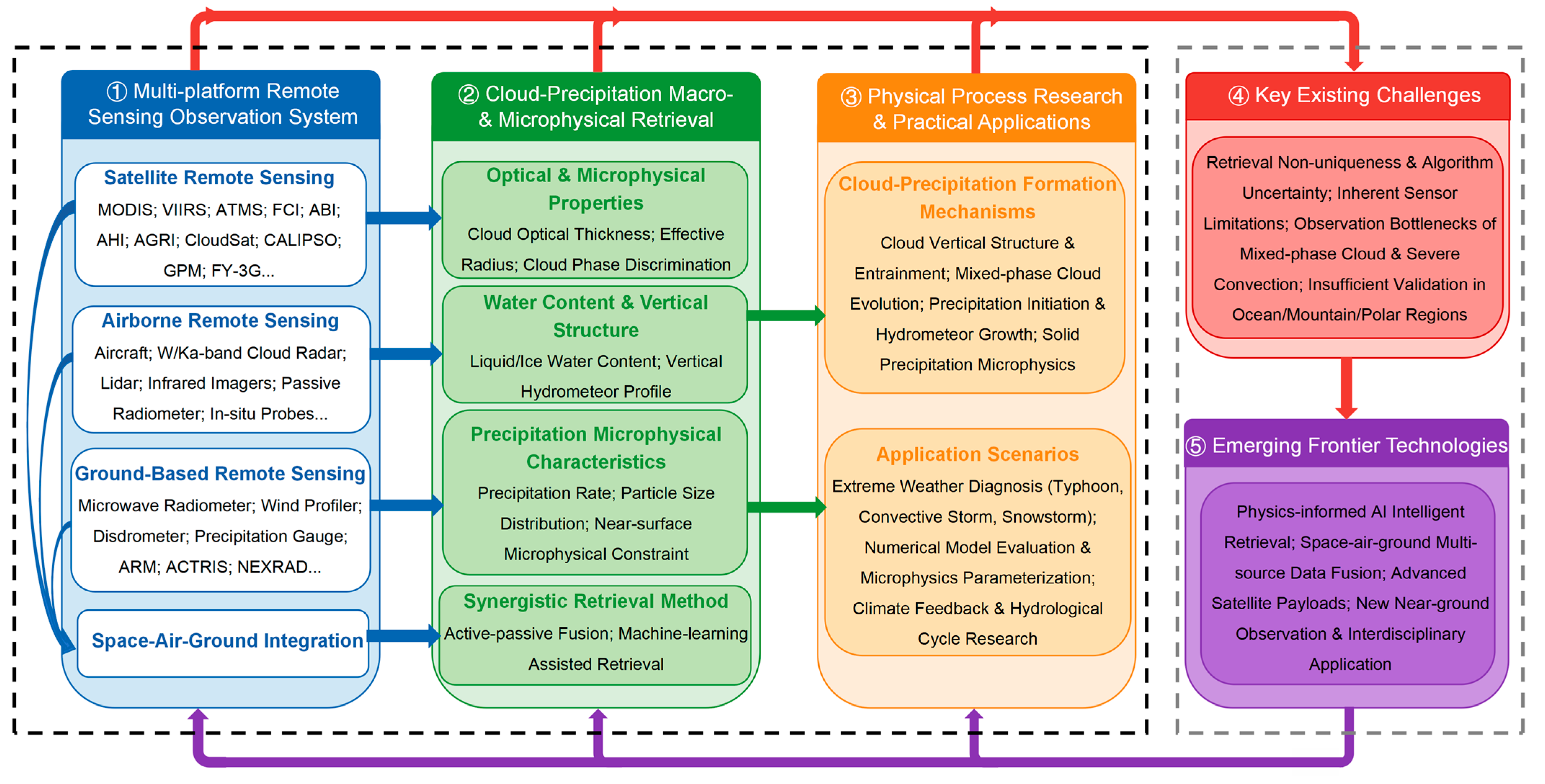

| Platform and Sensing Mode | Representative Systems | Observation Principle | Main Strengths | Key Limitations |
|---|---|---|---|---|
| Satellite passive sensing | (Polar-orbiting) MODIS, VIIRS, ATMS | Measure optical/infrared/microwave radiation to retrieve cloud and precipitation properties | Global coverage, multispectral observations, mature climate records | Limited temporal sampling, cloud heterogeneity, surface-background effects |
| (Geostationary) FCI, ABI, AHI, AGRI | Continuously observe optical/infrared radiation from fixed orbital positions for monitoring cloud-top properties | High temporal resolution, continuous monitoring | Limited vertical information, coarse spatial resolution, viewing-angle effects | |
| Satellite active sensing | CloudSat, CALIPSO, GPM DPR, FY-3G PMR, EarthCARE | Emit radar/lidar signals and analyze returned backscatter to characterize cloud and precipitation vertical structures | Vertical structure, phase discrimination, three-dimensional precipitation | Sampling gaps, attenuation, revisit constraints |
| Airborne remote sensing | W/Ka cloud radar, lidar, microwave radiometer, polarimeter | Combine active radar/lidar observations and passive microwave/optical measurements for targeted high-resolution sampling | Targeted high-resolution observations and satellite underflight validation | Short campaigns and limited spatial representativeness |
| Airborne in-situ | Cloud droplet probe, cloud/precipitation imaging probe, two-dimensional stereo probe, condensation particle counter, continuous-flow diffusion chamber | Directly sample cloud particles, aerosols, and hydrometeors to obtain microphysical properties | Direct particle-scale truth for retrieval and model evaluation | Safety and sampling constraints in severe weather |
| Ground-based profiling | Cloud radar, lidar, micro rain radar, microwave radiometer, wind profiler | Measure atmospheric columns using active and passive techniques to obtain vertical profiles of clouds, precipitation, thermodynamic state, and dynamics | Continuous vertical evolution and benchmark datasets | Local coverage and terrain/blockage issues |
| Ground precipitation sensing | Polarimetric radar, disdrometer, precipitation gauge, commercial microwave link | Detect hydrometeor scattering, particle size, and attenuation characteristics to quantify precipitation properties near the surface | Hydrometeor classification and near-surface precipitation characterization | Coverage gaps over ocean and remote regions, calibration needs |
| Variable | Sensors | Strength | Limitation | Best Use |
|---|---|---|---|---|
| COT/CER | Polar-orbiting and geostationary | Global coverage | Cloud heterogeneity | Climate studies |
| LWC/IWC | Radar and radiometer | Vertical information | Retrieval ambiguity | Mixed-phase |
| PSD (Dm/Nw) | DPR and polarimetric radar | Microphysics | Near-surface bias | Heavy rain |
| Precipitation phase | Lidar and radar | High accuracy | Attenuation | Ice/liquid |
| Process Category | Key Processes | Dominant Mechanisms | Observational Signatures | Main Observational Instruments | Physical Significance |
|---|---|---|---|---|---|
| Cloud dynamics and structure | Entrainment mixing | Turbulent mixing with environmental air, cloud-top radiative cooling | Broadening of particle size spectra, cloud-top variability | Cloud radar, lidar | Regulates cloud evolution and precipitation initiation |
| Phase transition | Liquid–ice phase conversion | Supercooled liquid water, ice nucleation processes | Mixed-phase cloud layers, coexistence of liquid and ice | Radar, lidar | Determines precipitation pathways and efficiency |
| Warm-rain processes | Collision-coalescence | Droplet collision efficiency and gravitational collection | Rapid increase in droplet size, onset, and intensification of rainfall | Radar, microwave radiometer | Dominant mechanism in maritime and shallow convection |
| Cold and mixed-phase processes | Deposition, aggregation, riming | Ice crystal growth, particle collision, supercooled water accretion | Formation of snow, graupel, and ice particles | Dual-polarization radar, airborne in-situ probes | Key processes for snowfall and intense precipitation |
| Precipitation initiation | Condensation-to-coalescence transition | Formation of critical droplet size threshold | Change in precipitation onset height, reflectivity increase | Cloud radar, GPM DPR, FY-3G PMR | Indicates the onset and timing of precipitation |
| Hydrometeor growth | Particle size distribution evolution | Microphysical growth and breakup processes | Variations in Dm and Nw parameters | Dual-frequency radar, polarimetric radar | Essential for quantitative precipitation estimation |
| Near-surface processes | Evaporation, breakup, melting | Thermodynamic and dynamical interactions near the surface | Reduction in droplet size, phase transition of hydrometeors | Disdrometer, precipitation gauge, weather radar | Modifies surface precipitation intensity and type |
Disclaimer/Publisher’s Note: The statements, opinions and data contained in all publications are solely those of the individual author(s) and contributor(s) and not of MDPI and/or the editor(s). MDPI and/or the editor(s) disclaim responsibility for any injury to people or property resulting from any ideas, methods, instructions or products referred to in the content. |
© 2026 by the authors. Licensee MDPI, Basel, Switzerland. This article is an open access article distributed under the terms and conditions of the Creative Commons Attribution (CC BY) license.
Share and Cite
Wu, Z.; Wen, L.; Zeng, Y.; Gultepe, I. Recent Progress in Remote Sensing of Clouds and Precipitation Physics: Platforms, Applications, and Emerging Frontiers. Remote Sens. 2026, 18, 2798. https://doi.org/10.3390/rs18162798
Wu Z, Wen L, Zeng Y, Gultepe I. Recent Progress in Remote Sensing of Clouds and Precipitation Physics: Platforms, Applications, and Emerging Frontiers. Remote Sensing. 2026; 18(16):2798. https://doi.org/10.3390/rs18162798
Chicago/Turabian StyleWu, Zuhang, Long Wen, Yong Zeng, and Ismail Gultepe. 2026. "Recent Progress in Remote Sensing of Clouds and Precipitation Physics: Platforms, Applications, and Emerging Frontiers" Remote Sensing 18, no. 16: 2798. https://doi.org/10.3390/rs18162798
APA StyleWu, Z., Wen, L., Zeng, Y., & Gultepe, I. (2026). Recent Progress in Remote Sensing of Clouds and Precipitation Physics: Platforms, Applications, and Emerging Frontiers. Remote Sensing, 18(16), 2798. https://doi.org/10.3390/rs18162798