A Spatiotemporal Drought Analysis Application Implemented in the Google Earth Engine and Applied to Iran as a Case Study
Abstract
1. Introduction
1.1. What Is Drought?
1.2. Climate Classification
1.3. Drought Indices
1.4. Previous Research on Drought
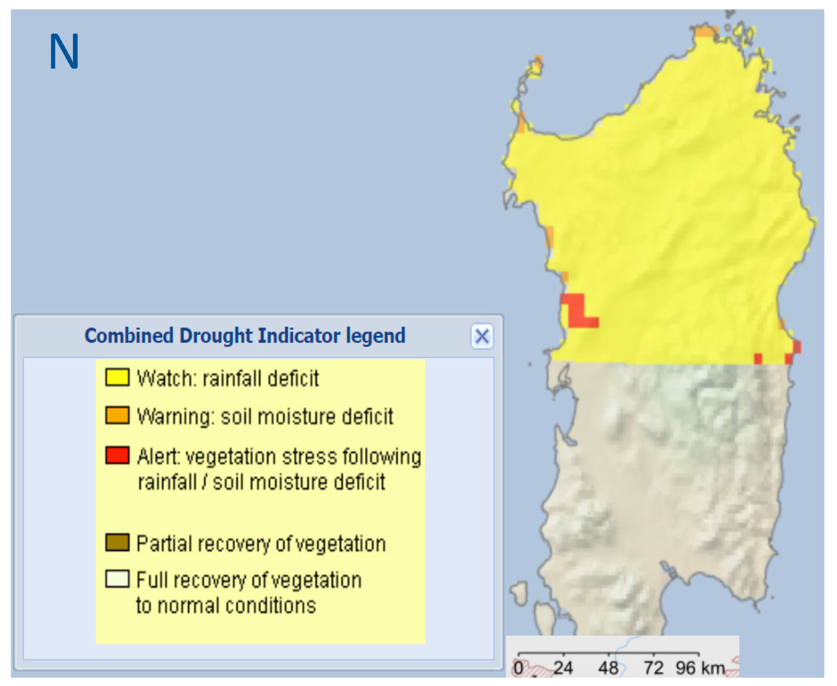
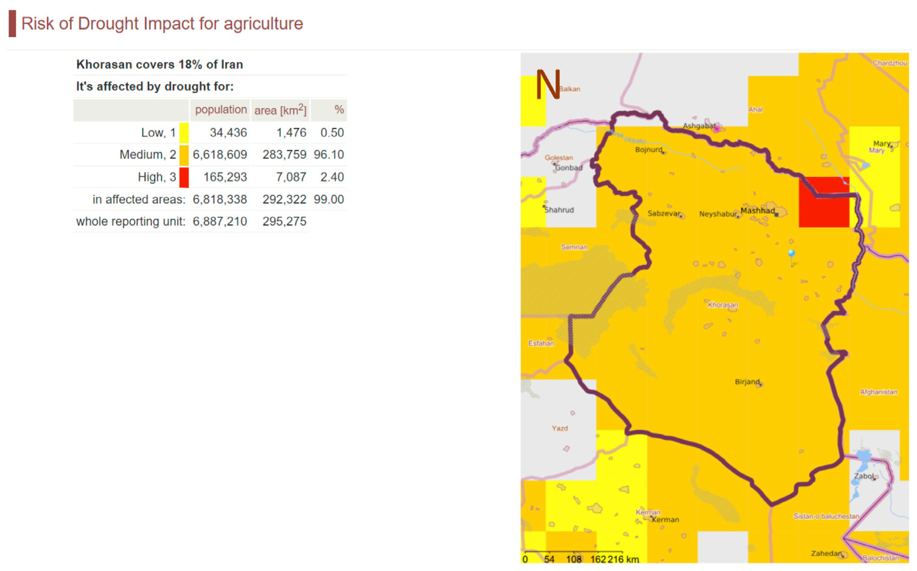
1.5. Drought Monitoring Services
1.6. Iran as a Study Area for Drought Monitoring
1.7. Remote Sensing-Based Monitoring of Drought with Google Earth Engine
2. Materials and Methods
2.1. Study Area
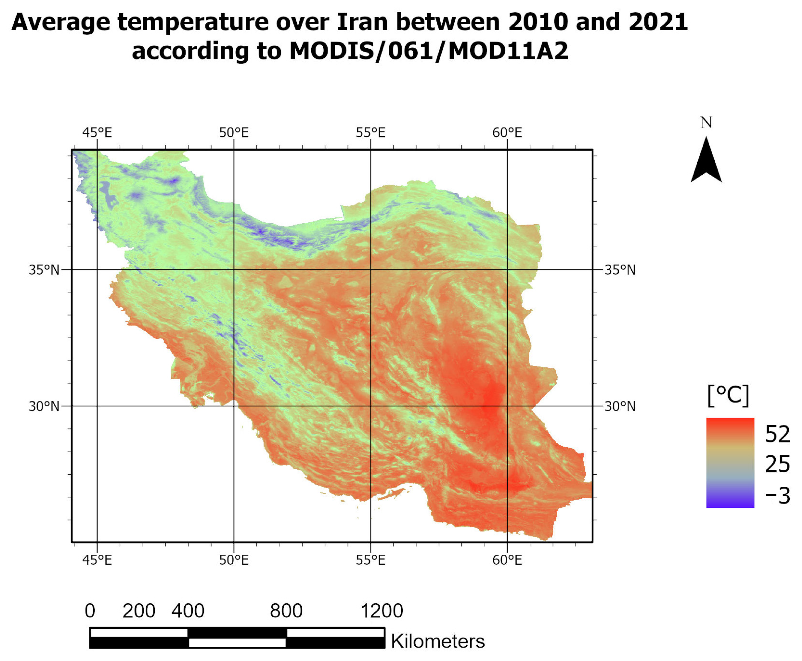
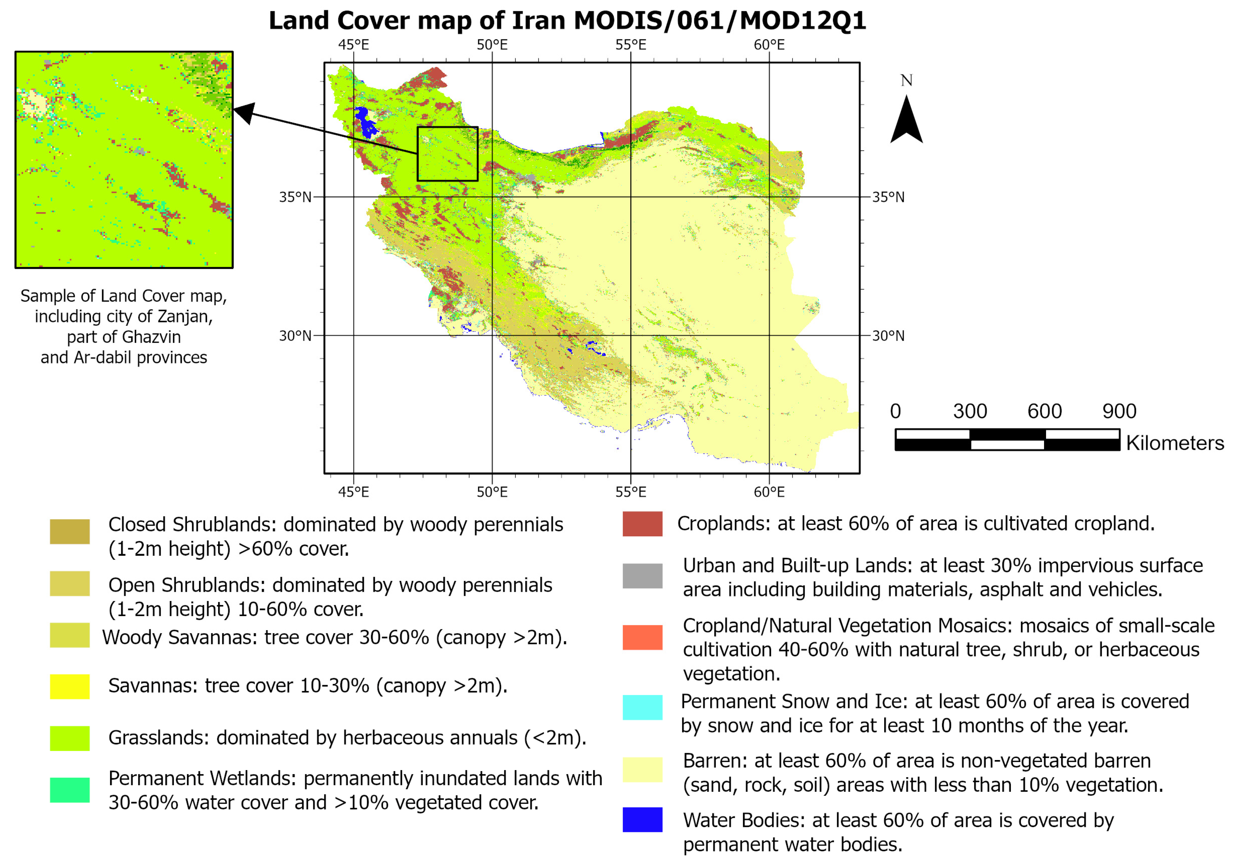
2.2. Remotely Sensed Derived Data
2.2.1. Vegetation Condition Index (VCI)
2.2.2. Temperature Condition Index (TCI)
2.2.3. Precipitation Condition Index (PCI)
3. Methodology
3.1. Climate Classification
3.2. Scaled Drought Combined Indicator (SDCI)
4. Results of Drought Analysis over Iran
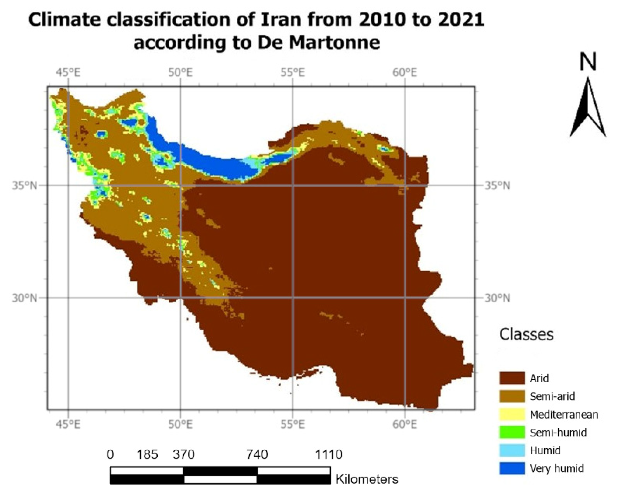
4.1. Climate Classification of Iran
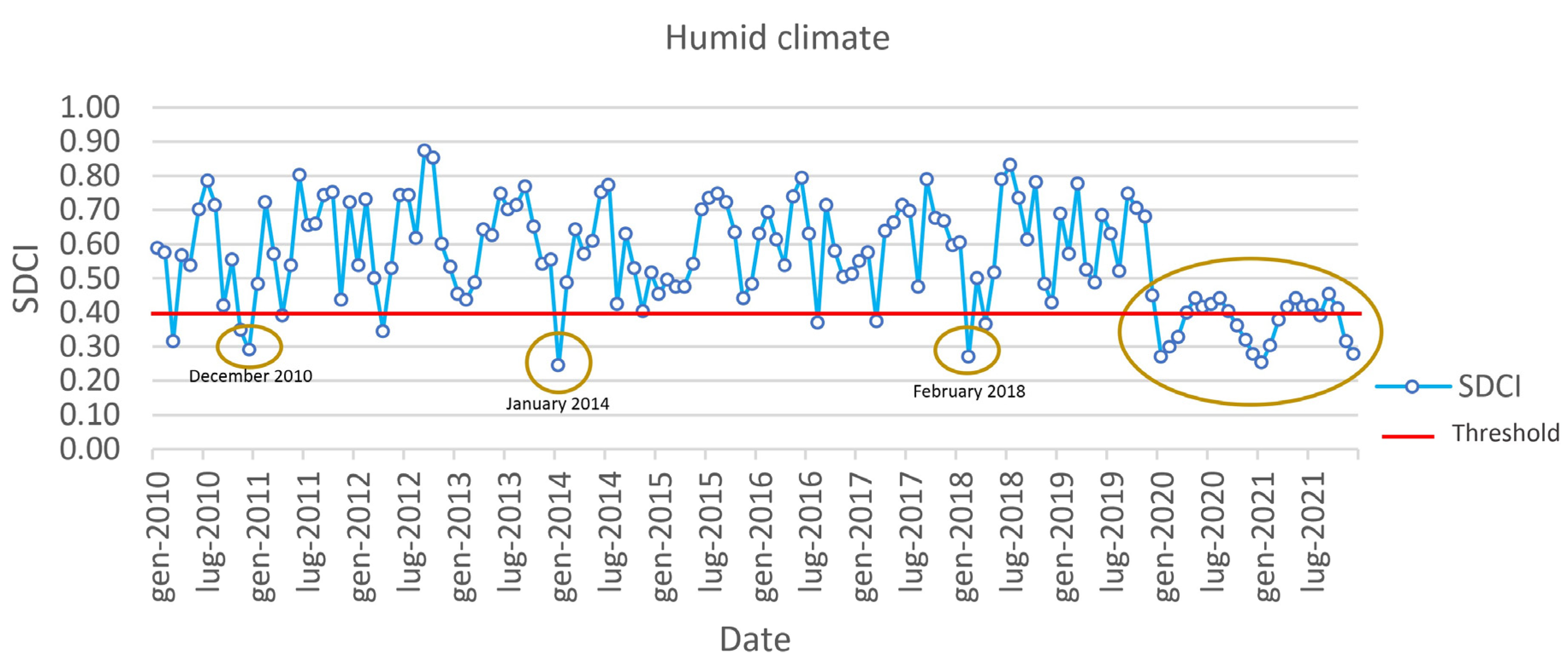
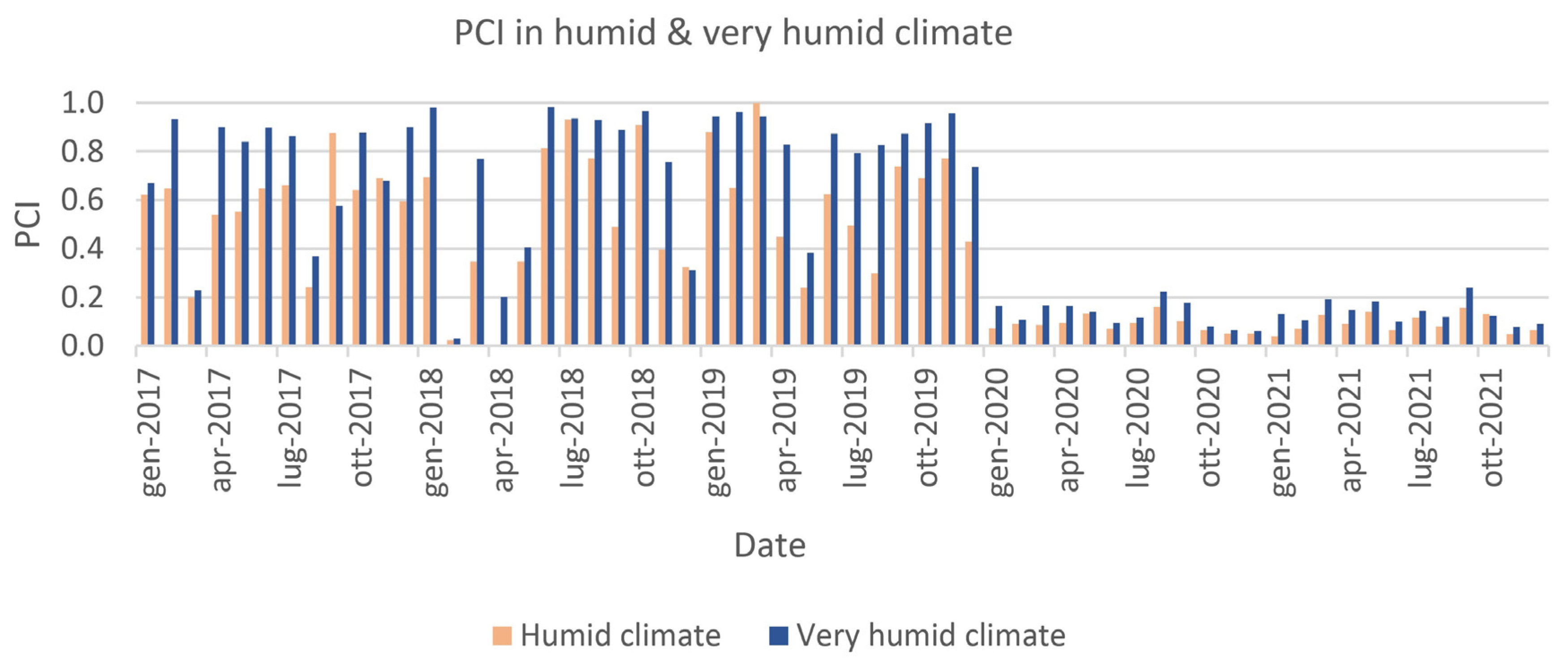
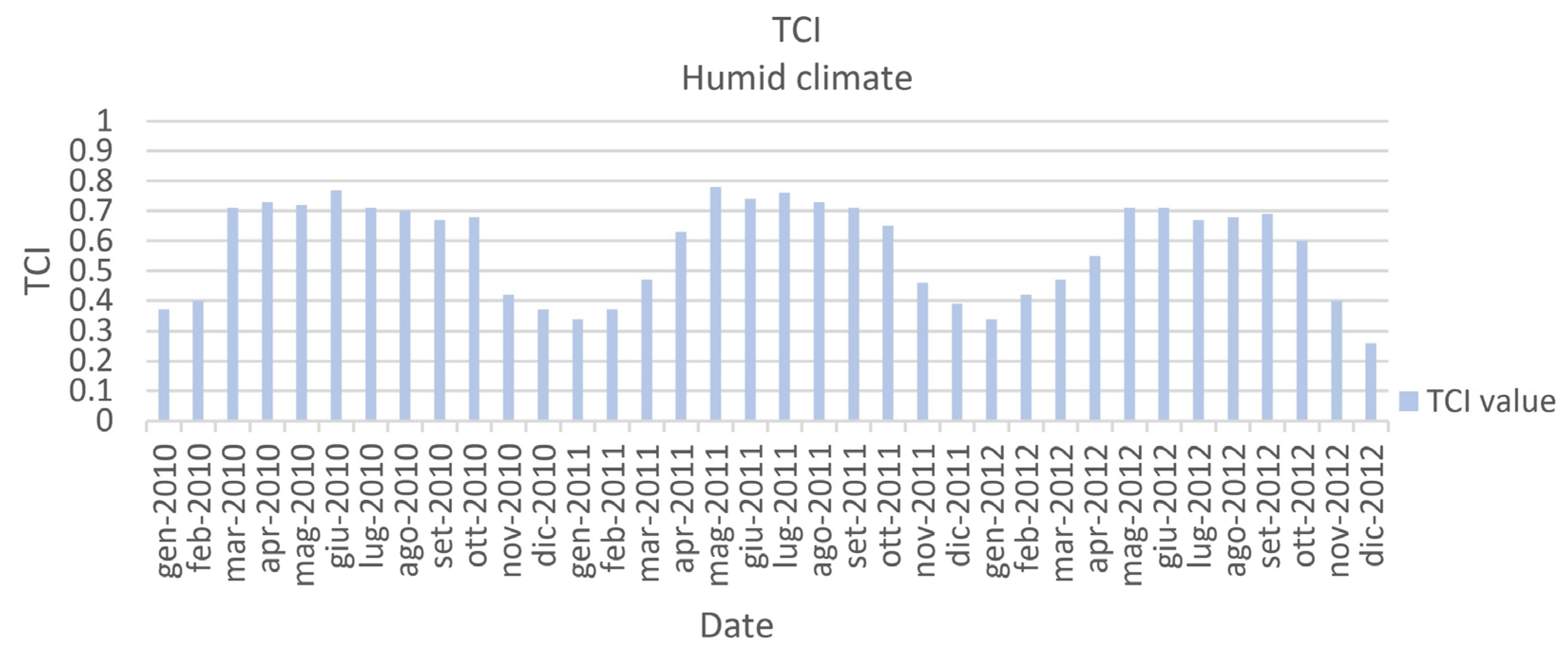
4.2. Humid and Very Humid Climate
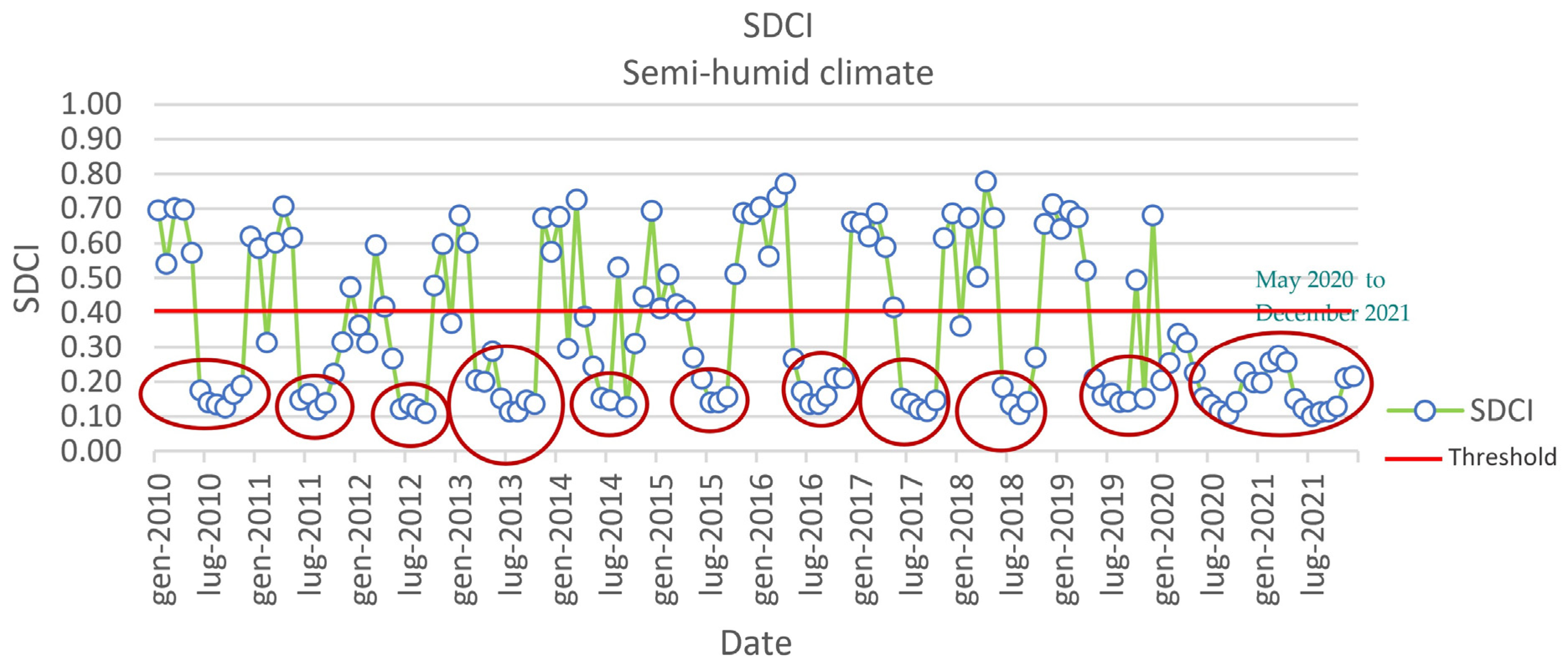
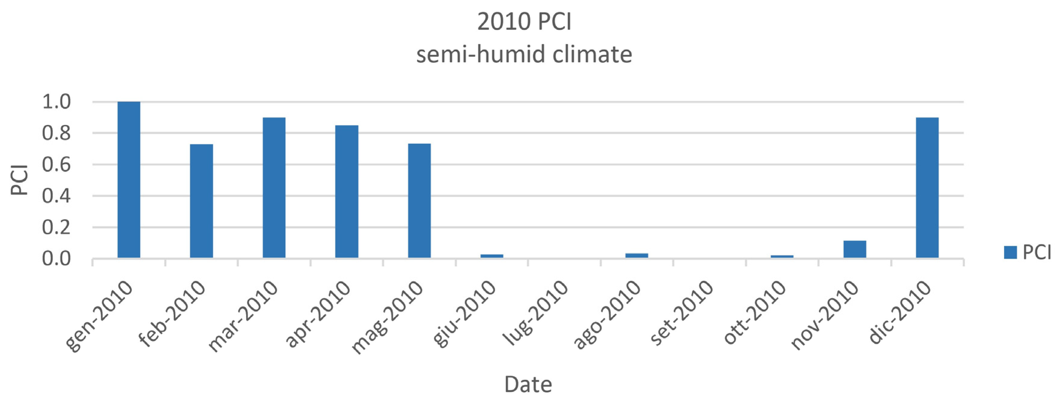
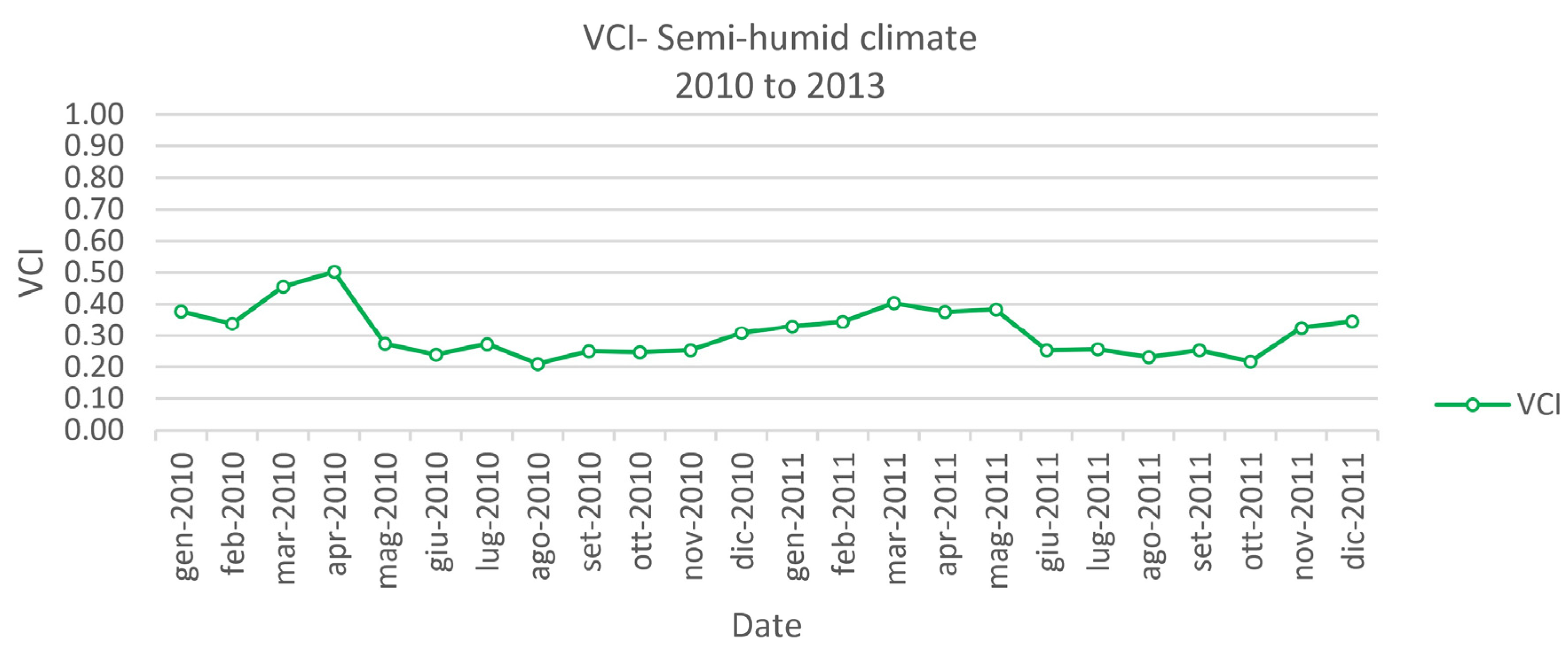
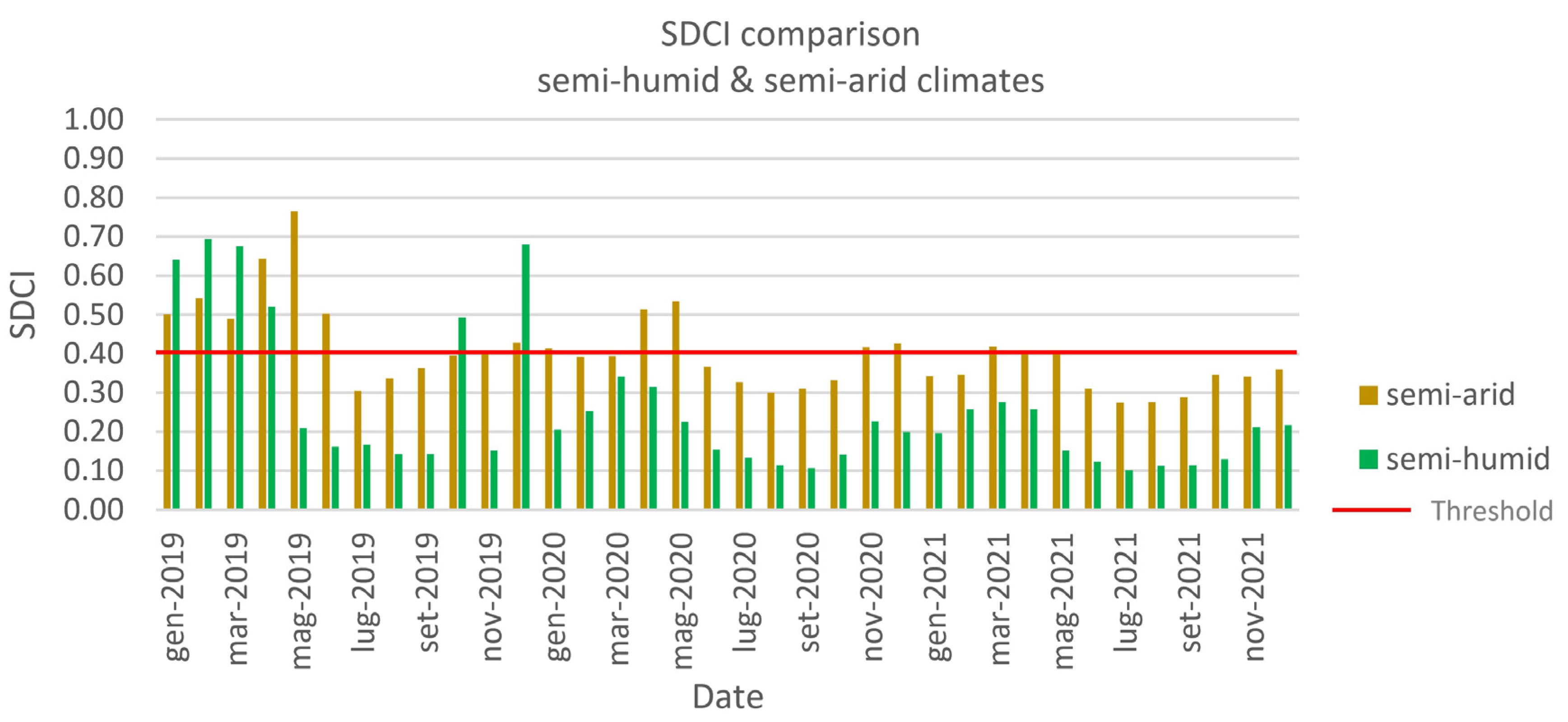
4.3. Semi-Humid Climate
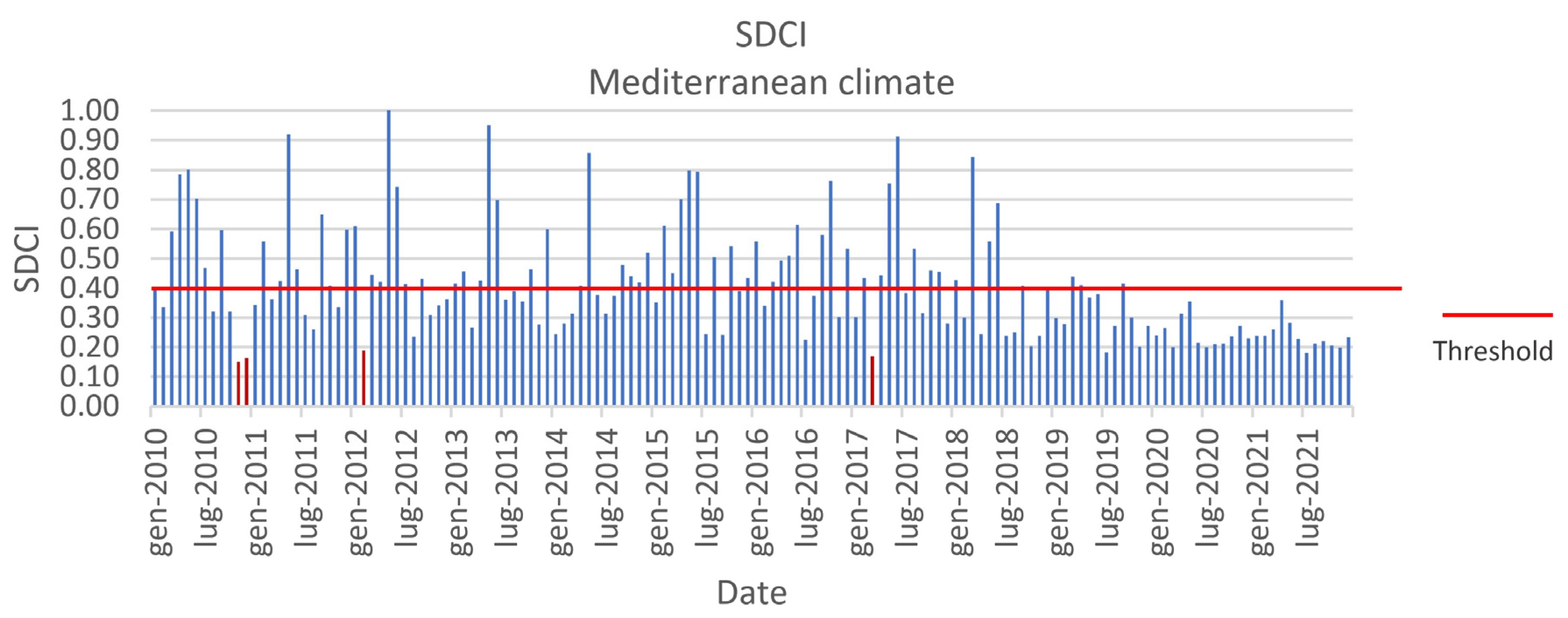
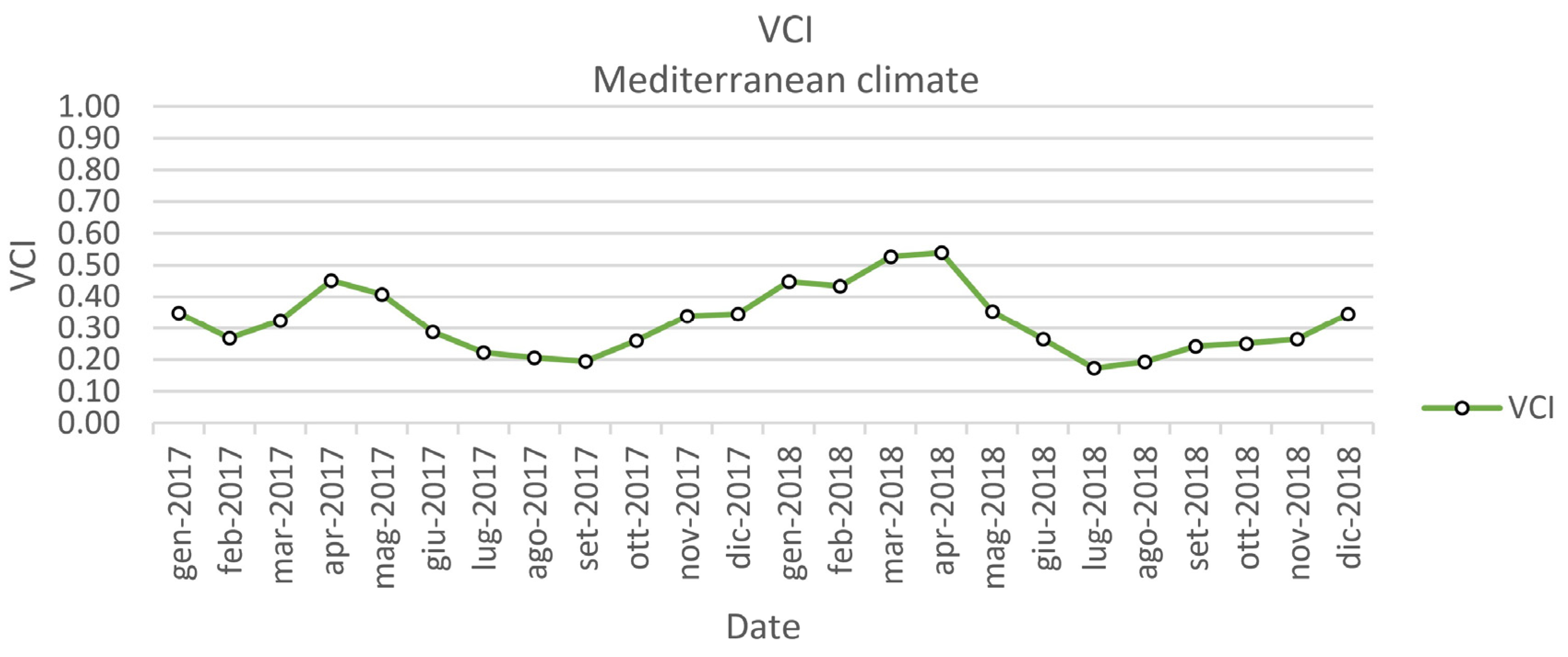
4.4. Mediterranean Climate
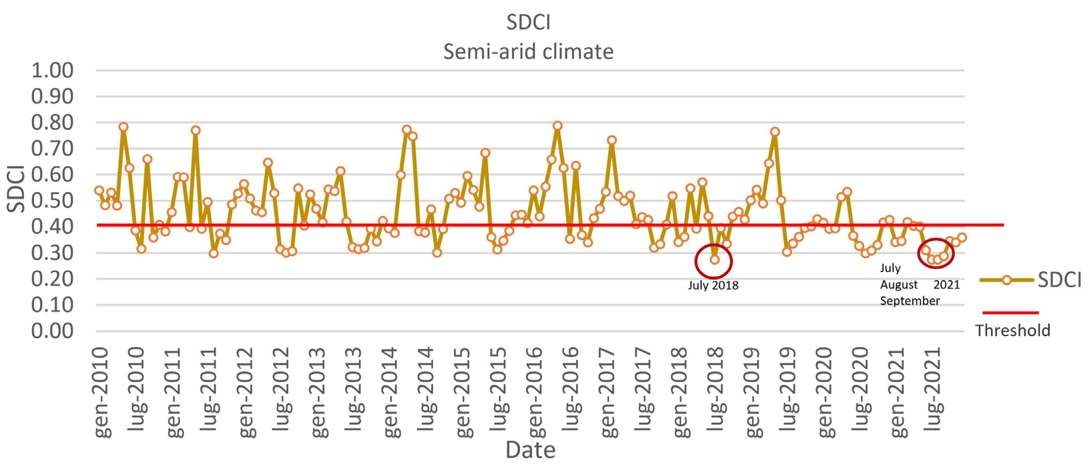
4.5. Semi-Arid Climate
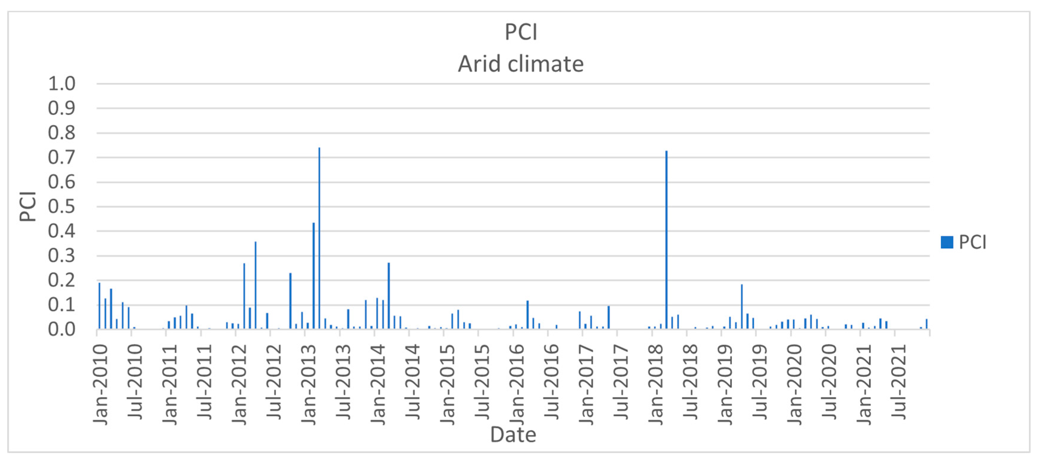
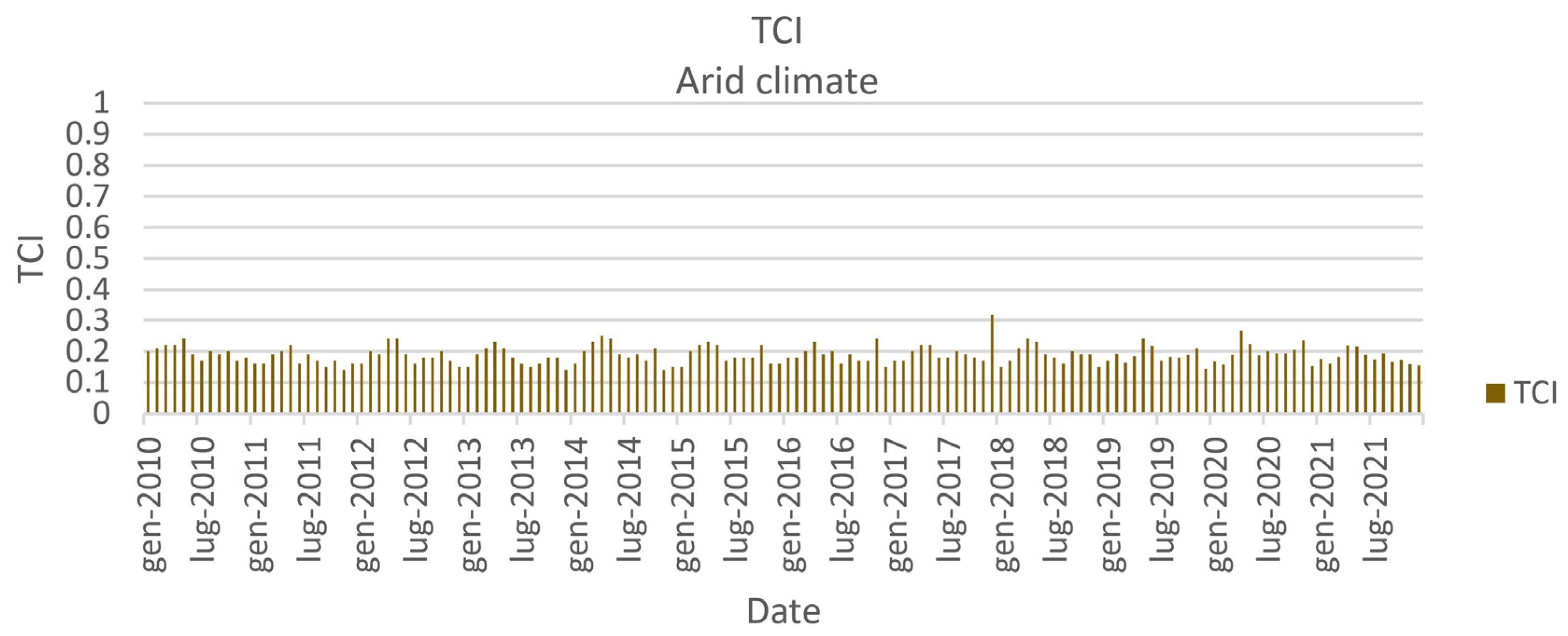
4.6. Arid Climate
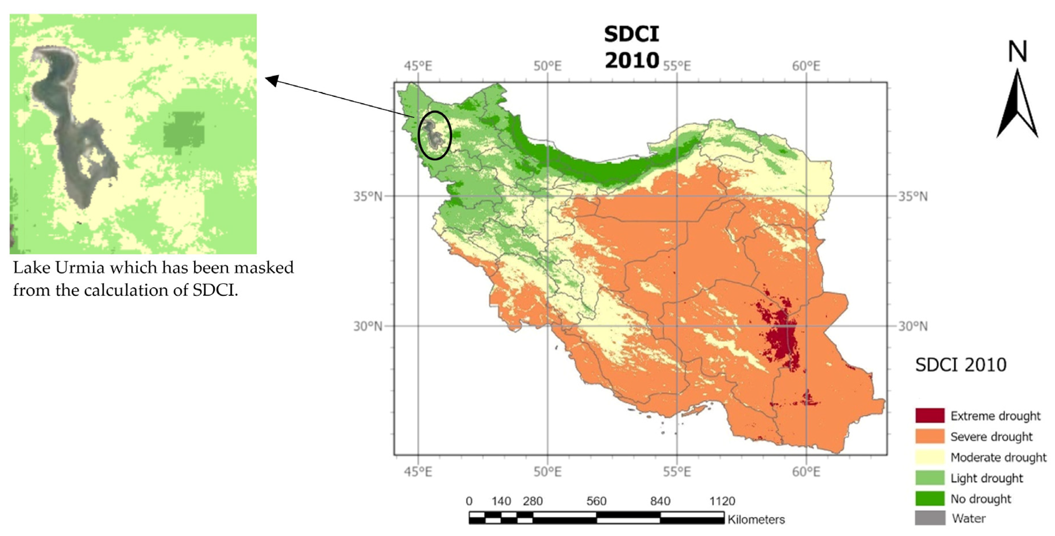
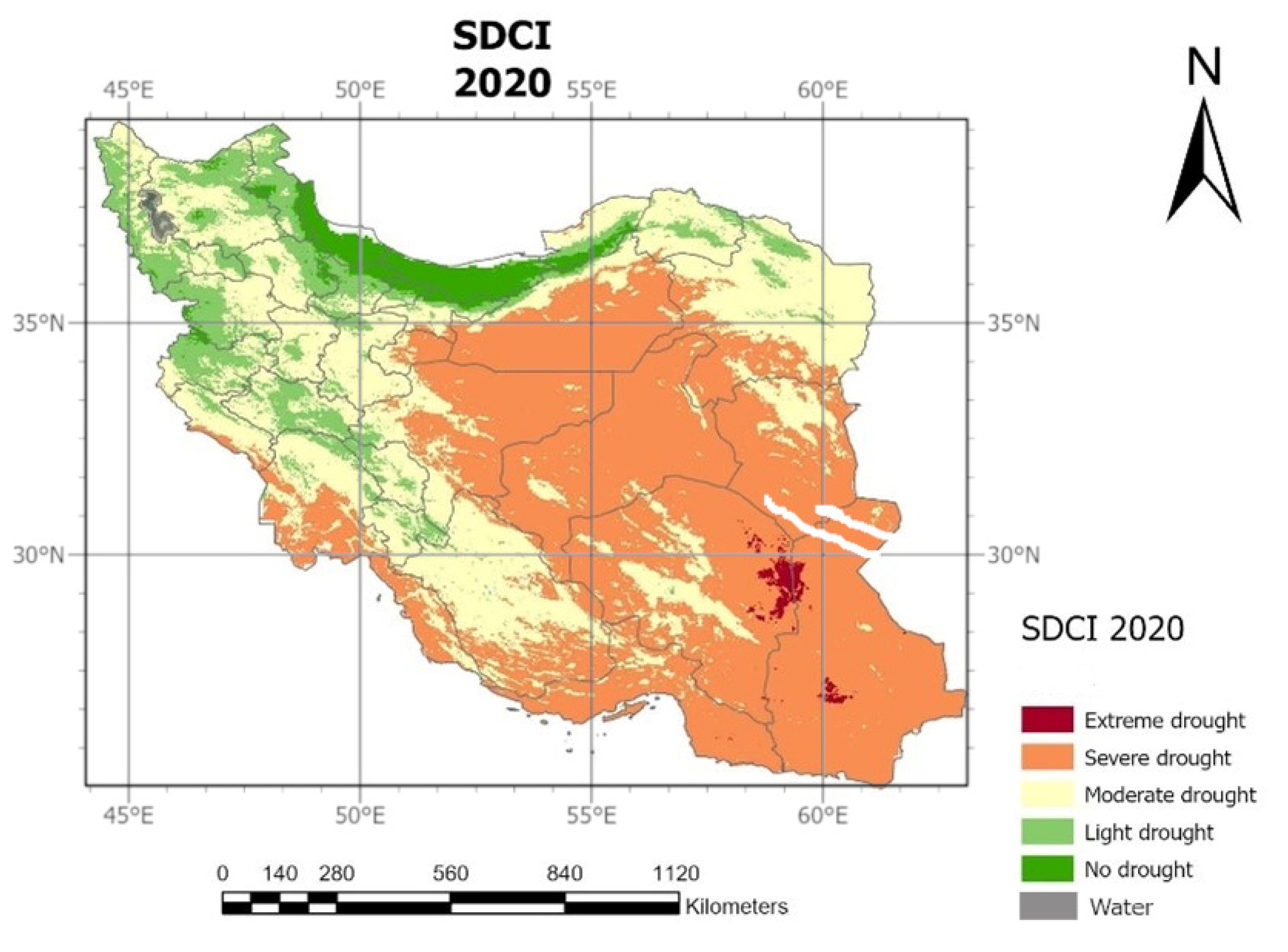
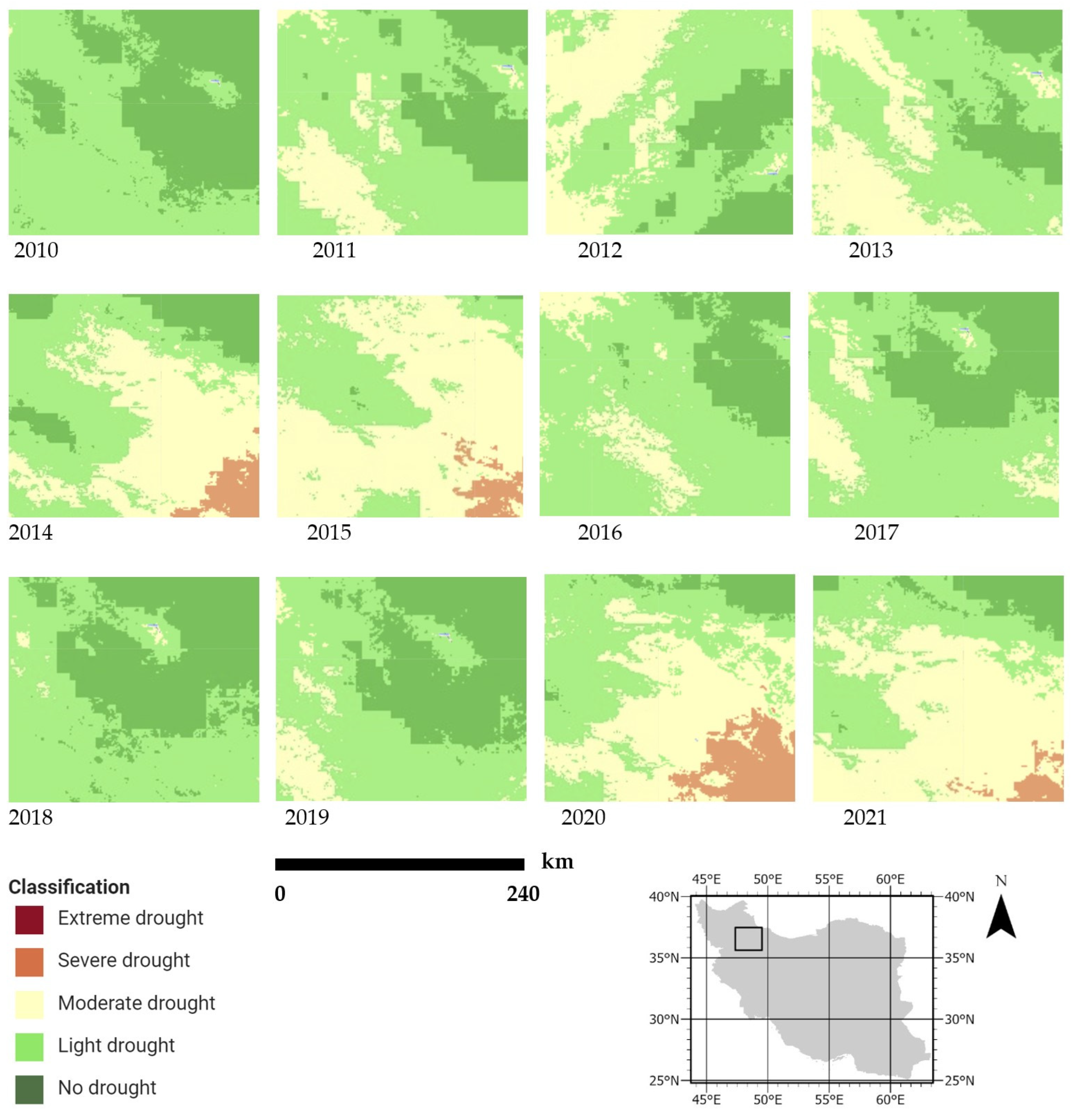
4.7. Spatial Analysis of Drought in Iran
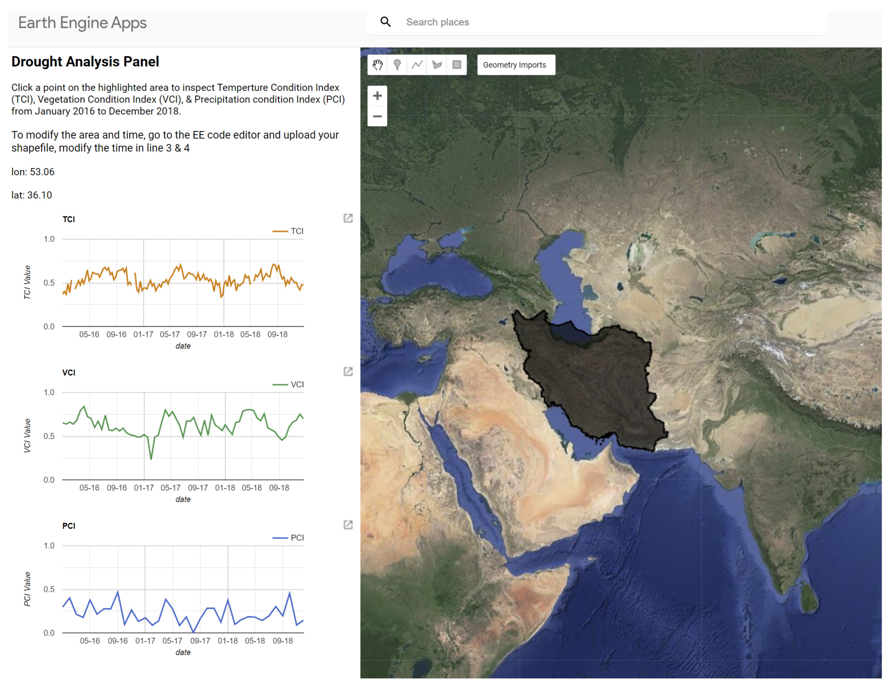
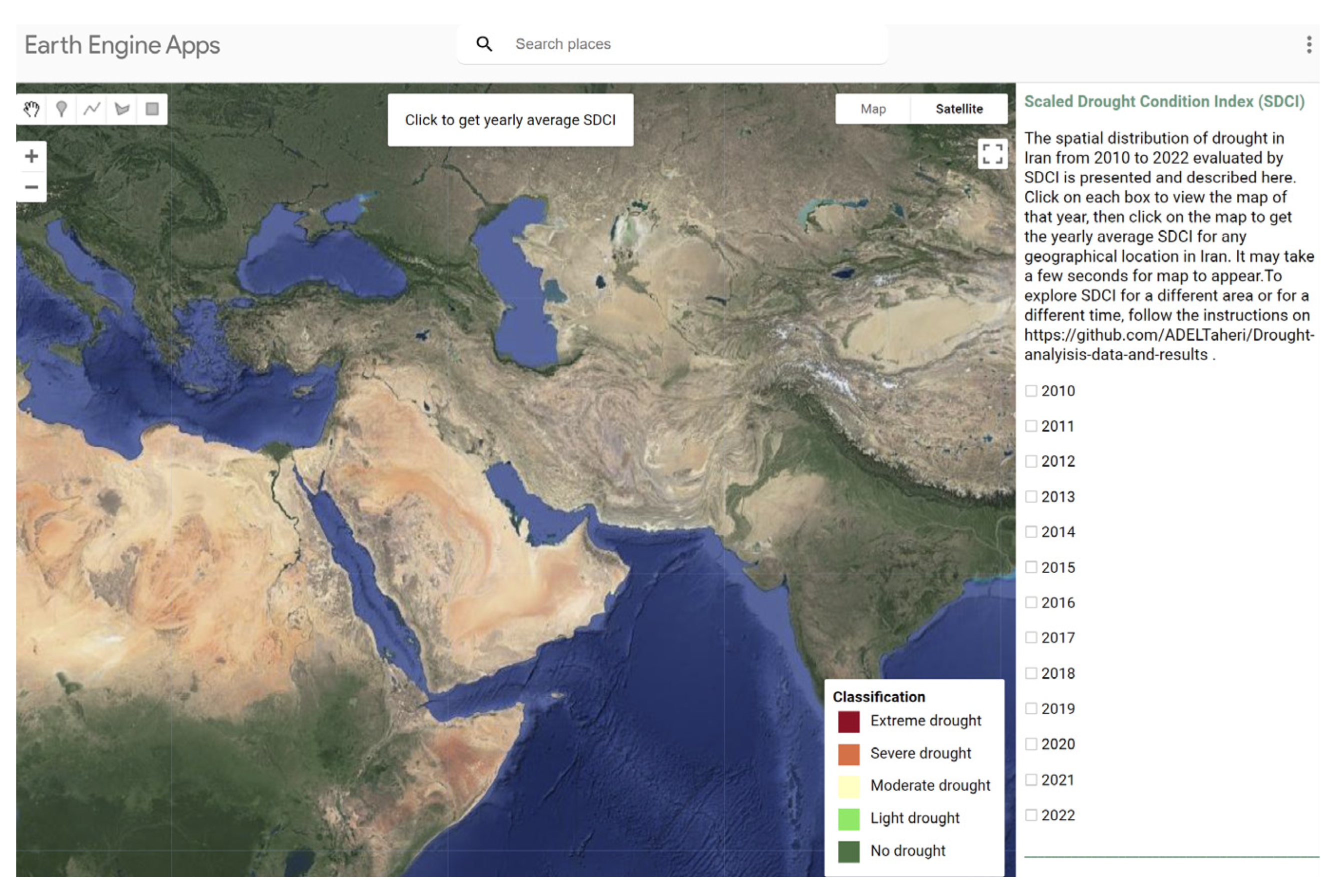
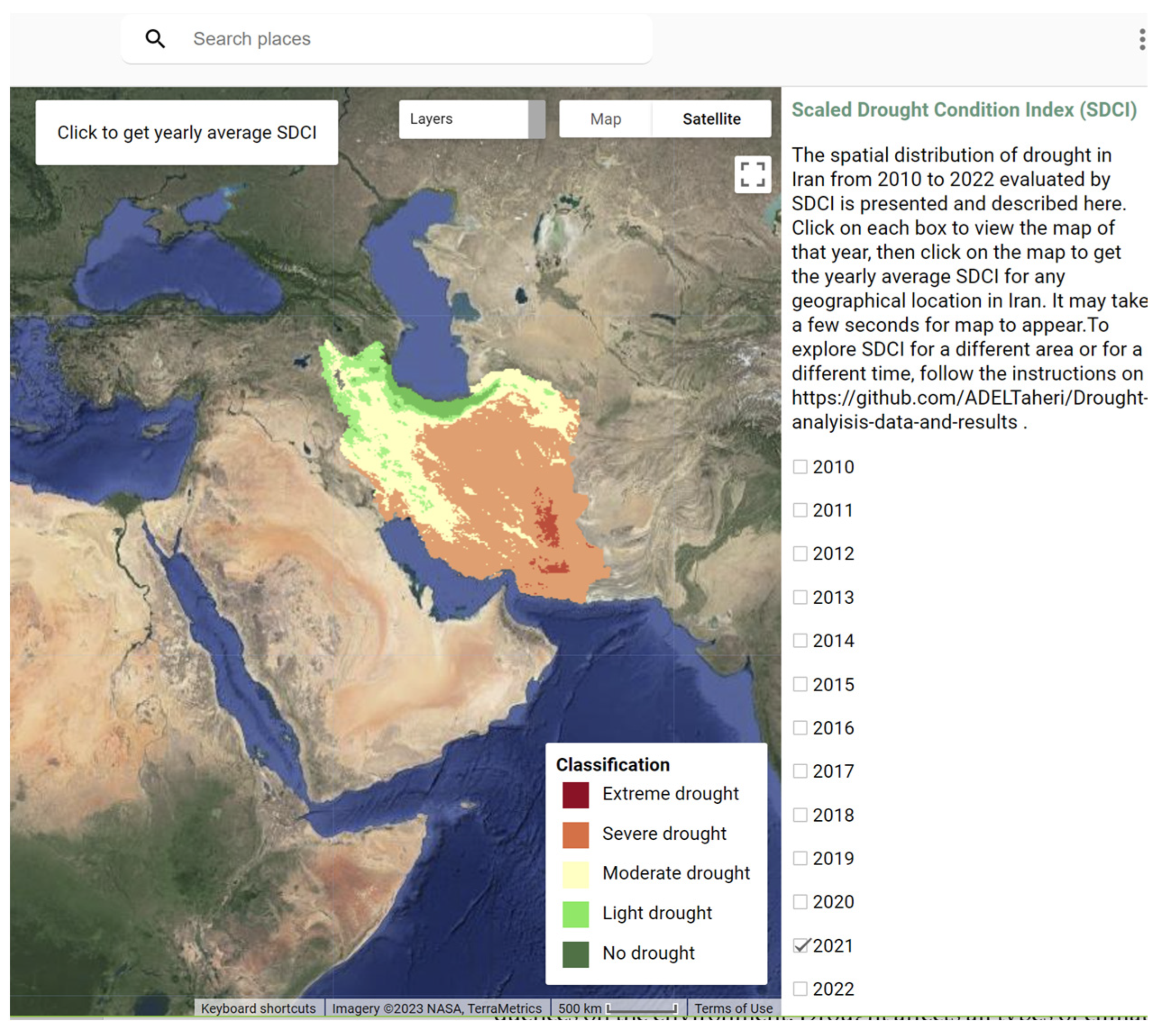
4.8. Google Earth Engine Drought Application
5. Conclusions
Author Contributions
Funding
Data Availability Statement
Conflicts of Interest
References
- Erian, W.; Pulwarty, R.; Vogt, J.V.; AbuZeid, K.; Bert, F.; Bruntrup, M.; El-Askary, H.; de Estrada, M.; Gaupp, F.; Grundy, M.; et al. GAR Special Report on Drought 2021; United Nations Office for Disaster Risk Reduction (UNDRR): Geneva, Switzerland, 2021. [Google Scholar]
- Pörtner, H.-O.; Roberts, D.C.; Tignor, M.M.B.; Poloczanska, E.; Mintenbeck, K.; Alegría, A.; Craig, M.; Langsdorf, S.; Löschke, S.; Möller, V.; et al. Climate Change 2022: Impacts, Adaptation and Vulnerability; IPCC Sixth Assessment Report; Cambridge University Press: Cambridge, UK; New York, NY, USA, 2022. [Google Scholar]
- United Nations Office for Disaster Risk Reduction (UNDRR). Global Assessment Report on Disaster Risk Reduction 2019; UN Office for Disaster Risk Reduction: Geneva, Switzerland, 2019. [Google Scholar]
- Alcamo, J.; Henrichs, T. Critical regions: A model-based estimation of world water resources sensitive to global changes. Aquat. Sci. 2002, 64, 352–362. [Google Scholar] [CrossRef]
- Deniz, A.; Toros, H.; Incecik, S. Spatial Variations of Climate Indices in Turke. Int. J. Climatol. 2011, 31, 394–403. [Google Scholar] [CrossRef]
- Spinoni, J.; Barbosa, P.; De Jager, A.; McCormick, N.; Naumann, G.; Vogt, J.V.; Magni, D.; Masante, D.; Mazzeschi, M. A new global database of meteorological drought events from 1951 to 2016. J. Hydrol. Reg. Stud. 2019, 22, 100593. [Google Scholar] [CrossRef] [PubMed]
- Wilhite, D.A.; Svoboda, M.D.; Hayes, M.J. Understanding the complex impacts of drought: A key to enhancing drought mitigation and preparedness. Water Resour. Manag. 2007, 21, 763–774. [Google Scholar] [CrossRef]
- Farajzadeh, M.; Ahmadian, K. Temporal and Spatial Analysis of Drought with use of SPI Index in Iran. J. Nat. Environ. Hazards 2014, 3, 1–16. [Google Scholar]
- Wilhite, D.A.; Glantz, M.H. Understanding the Drought Phenomenon: The Role of Definitions. Water Int. 1985, 10, 111–120. [Google Scholar] [CrossRef]
- Sepulcre-Canto, G.; Horion, S.; Singleton, H.; Carrao, H.; Vogt, J. Development of a Combined Drought Indicator to detect agricultural drought in Europe. Nat. Hazards Earth Syst. Sci. 2012, 12, 3519–3531. [Google Scholar] [CrossRef]
- Arora, V.K. The use of the aridity index to assess climate change effect on annual runoff. J. Hydrol. 2002, 265, 164–177. [Google Scholar] [CrossRef]
- Liu, X.; Zhang, D.; Luo, Y.; Liu, C. Spatial and temporal changes in aridity index in northwest China: 1960 to 2010. Theor. Appl. Climatol. 2013, 112, 307–316. [Google Scholar] [CrossRef]
- Levin, N.E.; Cerling, T.E.; Passey, B.H.; Harris, J.M.; Ehleringer, J.R. A stable isotope aridity index for terrestrial environments. Proc. Natl. Acad. Sci. USA 2006, 103, 11201–11205. [Google Scholar] [CrossRef]
- Araghi, A.; Martinez, C.J.; Adamowski, J.; Losen, J.E. Spatiotemporal variations of aridity in Iran using high-resolution gridded data. Int. J. Climatol. 2018, 38, 2701–2717. [Google Scholar] [CrossRef]
- Pellicone, G.; Caloiero, T.; Guagliardi, I. The De Martonne aridity index in Calabria (Southern Italy). J. Maps 2019, 15, 788–796. [Google Scholar] [CrossRef]
- Paltineanu, C.; Tanasescu, N.; Chitu, E.; Mihailescu, I.F. Relationships between the De Martonne aridity index and water requirements of some representative crops: A case study from Romania. Int. Agrophysics 2007, 21, 81–93. [Google Scholar]
- Haider, S.; Adnan, S. Classification and assessment of aridity over Pakistan provinces (1960–2009). Int. J. Environ. 2014, 3, 24–35. [Google Scholar] [CrossRef]
- De Martonne, E. Notions Generales. Climat. Hydrographie 9; Librarie Armand Colin: Paris, France, 1957; Volume 1. [Google Scholar]
- Gavrilov, M.B.; An, W.; Xu, C.; Radaković, M.G.; Hao, Q.; Yang, F.; Guo, Z.; Perić, Z.; Gavrilov, G.; Marković, S.B. Independent aridity and drought pieces of evidence based on meteorological data and tree ring data in Southeast Banat, Vojvodina, Serbia. Atmosphere 2019, 10, 586. [Google Scholar] [CrossRef]
- Mishra, V.N.; Rai, P.K. A remote sensing aided multi-layer perceptron-Markov chain analysis for land use and land cover change prediction in Patna district (Bihar), India. Arab. J. Geosci. 2016, 9, 249. [Google Scholar] [CrossRef]
- World Meteorological Organization (WMO). WMO Statement on the Status of the Global Climate in 2012; World Meteorological Organization: Geneva, Switzerland, 2013. [Google Scholar]
- Pande, C.B.; Al-Ansari, N.; Kushwaha, N.L.; Srivastava, A.; Noor, R.; Kumar, M.; Moharir, K.N.; Elbeltagi, A. Forecasting of SPI and Meteorological Drought Based on the Artificial Neural Network and M5P Model Tree. Land 2022, 11, 2040. [Google Scholar] [CrossRef]
- Yazdanpanah, M.; Hayati, D.; Hochrainer-Stigler, S.; Zamani, G.H. Understanding farmers’ intention and behavior regarding water conservation in the Middle-East and North Africa: A case study in Iran. J. Environ. Manag. 2014, 135, 63–72. [Google Scholar] [CrossRef]
- Dehkordi, R.M.; Yadegari, M.; Hamedi, B. Effect of temperature, drought and salinity stresses on germination of Portulaca oleracea L., Trigonella foenum-graecium L., Borago officinalis L. and Hypericum perforatum L. Adv. Environ. Biol. 2015, 9, 148–152. [Google Scholar]
- Gorelick, N.; Hancher, M.; Dixon, M.; Ilyushchenko, S.; Thau, D.; Moore, R. Google Earth Engine: Planetary-scale geospatial analysis for everyone. Remote Sens. Environ. 2017, 202, 18–27. [Google Scholar] [CrossRef]
- Qin, Y.; Yang, D.; Lei, H.; Xu, K.; Xu, X. Comparative analysis of drought based on precipitation and soil moisture indices in Haihe basin of North China during the period of 1960–2010. J. Hydrol. 2015, 526, 55–67. [Google Scholar] [CrossRef]
- Du, L.; Tian, Q.; Yu, T.; Meng, Q.; Jancso, T.; Udvardy, P.; Huang, Y. A comprehensive drought monitoring method integrating MODIS and TRMM data. Int. J. Appl. Earth Obs. Geoinf. 2013, 23, 245–253. [Google Scholar] [CrossRef]
- Rouse, J.W.; Haas, R.H.; Schell, J.A.; Deering, D.W. Monitoring Vegetation Systems in the Great Plains with ERTS (Earth Resources Technology Satellite). In Proceedings of the 3rd Earth Resources Technology Satellite Symposium, Washington, DC, USA, 10–14 December 1973; SP-351. pp. 309–317. [Google Scholar]
- Fazel Dehkordi, L.; Alsadat Sohrabi, T.; Mahmoodi Kohan, F. Drought monitoring by using of MODIS satellite images in dry lands (Case study: Isfahan Rangelands). Geogr. Environ. Plan. 2016, 27, 177–190. (In Farsi) [Google Scholar]
- Anyamba, A.; Tucker, C.J. Historical perspective of AVHRR NDVI and vegetation drought monitoring. Remote Sens. Drought Innov. Monit. Approaches 2012, 23, 20. [Google Scholar]
- Kogan, F.N. Droughts of the late 1980s in the United States as derived from NOAA polar-orbiting satellite data. Bull. Am. Meteorol. Soc. 1995, 76, 655–668. [Google Scholar] [CrossRef]
- Kogan, F.N. Application of vegetation index and brightness temperature for drought detection. Adv. Space Res. 1995, 15, 91–100. [Google Scholar] [CrossRef]
- Kogan, F.N. Global drought watch from space. Bull. Am. Meteorol. Soc. 1997, 78, 621–636. [Google Scholar] [CrossRef]
- Bhuiyan, C.; Singh, R.; Kogan, F. Monitoring drought dynamics in the Aravalli region (India) using different indices based on ground and remote sensing data. Int. J. Appl. Earth Obs. Geoinf. 2006, 8, 289–302. [Google Scholar] [CrossRef]
- Qu, C.; Hao, X.; Qu, J.J. Monitoring Extreme Agricultural Drought over the Horn of Africa (HOA) Using Remote Sensing Measurements. Remote Sens. 2019, 11, 902. [Google Scholar] [CrossRef]
- Choi, T.; Qu, J.J.; Xiong, X. A thirteen-year analysis of drought in the horn of Africa with MODIS NDVI and NWDI measurements. In Proceedings of the 2013 Second International Conference on Agro-Geoinformatics (Agro-Geoinformatics), Fairfax, VA, USA, 12–16 August 2013; pp. 302–307. [Google Scholar]
- Cao, Y.; Chen, S.; Wang, L.; Zhu, B.; Lu, T.; Yu, Y. An agricultural drought index for assessing droughts using a water balance method: A case study in Jilin Province, Northeast China. Remote Sens. 2019, 11, 1066. [Google Scholar] [CrossRef]
- Rhee, J.; Im, J.; Carbone, G.J. Monitoring agricultural drought for arid and humid regions using multi-sensor remote sensing data. Remote Sens. Environ. 2010, 114, 2875–2887. [Google Scholar] [CrossRef]
- Han, H.; Bai, J.; Yan, J.; Yang, H.; Ma, G. A combined drought monitoring index based on multi-sensor remote sensing data and machine learning. Geocarto Int. 2021, 36, 1161–1177. [Google Scholar] [CrossRef]
- Pei, F.; Wu, C.; Liu, X.; Li, X.; Yang, K.; Zhou, Y.; Wang, K.; Xu, L.; Xia, G. Monitoring the vegetation activity in China using vegetation health indices. Agric. For. Meteorol. 2018, 248, 215–227. [Google Scholar] [CrossRef]
- Shen, R.; Hiang, A.; Li, B.; Guo, J. Construction of a drought monitoring model using deep learning based on multi-source remote sensing data. Int. J. Appl. Earth Obs. Geoinf. 2019, 79, 48–57. [Google Scholar] [CrossRef]
- Cammalleri, C.; Arias-Muñoz, C.; Barbosa, P.; de Jager, A.; Magni, D.; Masante, D.; Mazzeschi, M.; McCormick, N.; Naumann, G.; Spinoni, J.; et al. A revision of the Combined Drought Indicator (CDI) used in the European Drought Observatory (EDO). Nat. Hazards Earth Syst. Sci. 2021, 21, 481–495. [Google Scholar] [CrossRef]
- Vogt, J.; Naumann, G.; Masante, D.; Spinoni, J.; Cammalleri, C.; Erian, W.; Pischke, F.; Pulwarty, R.; Barbosa, P. Drought Risk Assessment and Management: A Conceptual Framework; Publications Office of the European Union: Luxembourg, 2018. [Google Scholar]
- Mesgaran, M.; Madani, K.; Hashemi, H.; Azadi, P. Evaluation of Land and Precipitation for Agriculture in Iran; Stanford Iran 2040 Project; Stanford University: Stanford, CA, USA, 2016; Available online: https://purl.stanford.edu/vf990qz0340 (accessed on 10 February 2023).
- Safarianzengir, V.; Fatahi, A.; Sobhani, B.; Amiri Doumari, S. Temporal and spatial analysis and monitoring of drought (meteorology) and its impacts on environment changes in Iran. Atmos. Sci. Lett. 2022, 23, e1080. [Google Scholar] [CrossRef]
- Shahabfar, A.; Ghulam, A.; Eitzinger, J. Drought monitoring in Iran using the perpendicular drought indices. Int. J. Appl. Earth Obs. Geoinf. 2012, 18, 119–127. [Google Scholar] [CrossRef]
- Hamzeh, S.; Farahani, Z.; Mahdavi, S.; Chatrobgoun, O.; Gholamnia, M. Spatio-temporal monitoring of agricultural drought using remotely sensed data (Case study of Markazi province of Iran). J. Spat. Anal. Environ. Hazards 2017, 4, 53–70. (In Farsi) [Google Scholar]
- Doostan, R. Analysis of drought researches of Iran. J. Spat. Anal. Environ. Hazards 2020, 6, 53–94. (In Farsi) [Google Scholar] [CrossRef]
- Karimi, M.; Shahedi, K.; Raziei, T.; Miryaghoobzadeh, M. Analysis of Performance of vegetation indices on agricultural drought using remote sensing technique in Karkheh basin. Iran. J. Remote Sens. GIS 2020, 11, 29–46. (In Farsi) [Google Scholar] [CrossRef]
- Mehryar, S.; Sliuzas, R.; Sharifi, A.; van Maarseveen, M.F.A.M. The water crisis and socio-ecological development profile of Rafsanjan Township, Iran. WIT Trans. Ecol. Environ. 2015, 199, 271–285. [Google Scholar]
- Bozorg-Haddad, O.; Zolghadr-Asli, B.; Sarzaeim, P.; Aboutalebi, M.; Chu, X.; Loáiciga, H.A. Evaluation of water shortage crisis in the Middle East and possible remedies. J. Water Supply: Res. Technol. -AQUA 2020, 69, 85–98. [Google Scholar] [CrossRef]
- Ashraf, S.; AghaKouchak, A.; Nazemi, A.; Mirchi, A.; Sadegh, M.; Moftakhari, H.R.; Hassanzadeh, E.; Miao, C.H.; Madani, K.; Mousavi Baygi, M.; et al. Compounding effects of human activities and climatic changes on surface water availability in Iran. Clim. Change 2019, 152, 379–391. [Google Scholar] [CrossRef]
- Moridi, A. State of water resources in Iran. Int. J. Hydrol. 2017, 1, 111–114. [Google Scholar] [CrossRef]
- Larijani, K.M. Iran’s water crisis: Inducers, challenges and counter-measures. In Proceedings of the ERSA 45th Congress of the European Regional Science Association, Amsterdam, The Netherlands, 23–27 August 2005. [Google Scholar]
- Madani, K.; AghaKouchak, A.; Mirchi, A. Iran’s socio-economic drought: Challenges of a water-bankrupt nation. Iran. Stud. 2016, 49, 997–1016. [Google Scholar] [CrossRef]
- Madani, K. Water management in Iran: What is causing the looming crisis? J. Environ. Stud. Sci. 2014, 4, 315–328. [Google Scholar] [CrossRef]
- Barthold, V.V. An Historical Geography of Iran; Princeton University Press: Princeton, NJ, USA, 2014; Volume 65. [Google Scholar]
- Wan, Z.; Hook, S.; Hulley, G. MOD11A2 MODIS/Terra land surface temperature/emissivity 8-day L3 global 1km SIN grid V006; NASA EOSDIS Land Processes DAAC: Sioux Falls, SD, USA, 2015; Volume 10, p. 10.5067. [Google Scholar]
- Funk, C.; Peterson, P.; Landsfeld, M.; Pedreros, D.; Verdin, J.; Shukla, S.; Husak, G.; Rowland, J.; Harrison, L.; Hoell, A.; et al. The climate hazards infrared precipitation with stations—A new environmental record for monitoring extremes. Sci. Data 2015, 2, 150066. [Google Scholar] [CrossRef] [PubMed]
- Tsiros, E.; Domenikiotis, C.; Spiliotopoulos, M.; Dalezios, N. Use of NOAA/AVHRR-based vegetation condition index (VCI) and temperature condition index (TCI) for drought monitoring in Thessaly, Greece. In Proceedings of the EWRA Symposium on Water Resources Management: Risks and Challenges for the 21st Century, Izmir, Turkey, 2–4 September 2004. [Google Scholar]
- Friedl, M.; Sulla-Menashe, D. MODIS/Terra+Aqua Land Cover Type Yearly L3 Global 500m SIN Grid V061; NASA EOSDIS Land Processes DAAC: Sioux Falls, SD, USA, 2022. [Google Scholar]
- Raziei, T. Climate of Iran according to Köppen-Geiger, Feddema, and UNEP climate classifications. Theor. Appl. Climatol. 2022, 148, 1395–1416. [Google Scholar] [CrossRef]
- Köppen, V.; Geiger, R. Handbuch der Klimatologie, 5 Vols.; Gerbrüder Borntraegar: Berlin, Germany, 1930; 44p. [Google Scholar]
- Available online: https://reliefweb.int/report/iran-islamic-republic/iran-droughts-operation-update-report-n-1-dref-n-mdrir005 (accessed on 21 February 2023).
- Huffman, G.J.; Bolvin, D.T.; Braithwaite, D.; Hsu, K.; Joyce, R.; Kidd, C.; Nelkin, E.J.; Sorooshian, S.; Tan, J.; Xie, P. NASA global precipitation measurement (GPM) integrated multi-satellite retrievals for GPM (IMERG). In Algorithm Theoretical Basis Document (ATBD) Version 06; National Aeronautics and Space Administration: Washington, DC, USA, 2019; Volume 4. [Google Scholar]



| Type of Climates | Values of Idm |
|---|---|
| Arid | IDM < 10 |
| Semi-arid | 10 ≤ IDM < 20 |
| Mediterranean | 20 ≤ IDM < 24 |
| Semi-humid | 24 ≤ IDM < 28 |
| Humid | 28 ≤ IDM < 35 |
| Very humid | IDM ≥ 35 |
| Classification | Sdci Index |
|---|---|
| Extreme drought | 0 ≤ SDCI < 0.1 |
| Severe drought | 0.1 ≤ SDCI < 0.2 |
| Moderate drought | 0.2 ≤ SDCI < 0.3 |
| Light drought | 0.3 ≤ SDCI < 0.4 |
| No drought | SDCI ≥ 0.4 |
Disclaimer/Publisher’s Note: The statements, opinions and data contained in all publications are solely those of the individual author(s) and contributor(s) and not of MDPI and/or the editor(s). MDPI and/or the editor(s) disclaim responsibility for any injury to people or property resulting from any ideas, methods, instructions or products referred to in the content. |
© 2023 by the authors. Licensee MDPI, Basel, Switzerland. This article is an open access article distributed under the terms and conditions of the Creative Commons Attribution (CC BY) license (https://creativecommons.org/licenses/by/4.0/).
Share and Cite
Taheri Qazvini, A.; Carrion, D. A Spatiotemporal Drought Analysis Application Implemented in the Google Earth Engine and Applied to Iran as a Case Study. Remote Sens. 2023, 15, 2218. https://doi.org/10.3390/rs15092218
Taheri Qazvini A, Carrion D. A Spatiotemporal Drought Analysis Application Implemented in the Google Earth Engine and Applied to Iran as a Case Study. Remote Sensing. 2023; 15(9):2218. https://doi.org/10.3390/rs15092218
Chicago/Turabian StyleTaheri Qazvini, Adel, and Daniela Carrion. 2023. "A Spatiotemporal Drought Analysis Application Implemented in the Google Earth Engine and Applied to Iran as a Case Study" Remote Sensing 15, no. 9: 2218. https://doi.org/10.3390/rs15092218
APA StyleTaheri Qazvini, A., & Carrion, D. (2023). A Spatiotemporal Drought Analysis Application Implemented in the Google Earth Engine and Applied to Iran as a Case Study. Remote Sensing, 15(9), 2218. https://doi.org/10.3390/rs15092218


