Article

A Seagrass Mapping Toolbox for South Pacific Environments

1
Centre for Environment, Fisheries and Aquaculture Science (Cefas), Pakefield Road, Lowestoft NR33 0HT, UK
2
Collaborative Centre for Sustainable Use of the Seas (CCSUS), School of Environmental Sciences, University of East Anglia, Norwich NR4 7TJ, UK
3
Catchment to Reef Research Group, TropWater, James Cook University, Townsville, QLD 4811, Australia
4
I-Sea, 33600 Pessac, France
*
Author to whom correspondence should be addressed.
Remote Sens. 2023, 15(3), 834; https://doi.org/10.3390/rs15030834
Submission received: 15 May 2022 / Revised: 19 July 2022 / Accepted: 30 January 2023 / Published: 2 February 2023

Abstract

:
Seagrass beds provide a range of ecosystem services but are at risk from anthropogenic pressures. While recent progress has been made, the distribution and condition of South Pacific seagrass is relatively poorly known and selecting an appropriate approach for mapping it is challenging. A variety of remote sensing tools are available for this purpose and here we develop a mapping toolbox and associated decision tree tailored to the South Pacific context. The decision tree considers the scale at which data are needed, the reason that monitoring is required, the finances available, technical skills of the monitoring team, data resolution, site safety/accessibility and whether seagrass is predominantly intertidal or subtidal. Satellite mapping is recommended for monitoring at the national and regional scale, with associated ground-reference data where possible but without if time and funds are limiting. At the local scale, satellite, remotely piloted aircraft (RPA), kites, underwater camera systems and in situ surveys are all recommended. In the special cases of community-based initiatives and emergency response monitoring, in situ or satellite/RPA are recommended, respectively. For other types of monitoring the primary driver is funding, with in situ, kite and satellite recommended when finances are limited and satellite, underwater camera, RPA or kites otherwise, dependent on specific circumstances. The tools can be used individually or in combination, though caution is recommended when combining tools due to data comparability.

1. Introduction

Coastal habitats are the frontier between land and ocean. They provide ecosystem services including food, coastal protection, construction materials, recreational opportunities and cultural wellbeing, and there is an innate value to their biodiversity. Seagrasses, particularly, are extolled for their ecosystem benefits such as provision of fish nurseries, pollution filtration, sediment stabilisation, provision of food sources and, more recently, potential to sequester carbon [1,2,3,4,5]. In tropical regions such as the Indo-Pacific, seagrass beds also support turtles, manatees and dugongs, providing them with food [6]; they provide at least 30 different service benefits in the Indo-Pacific region, including coastal protection, food provision, nursery habitat, cultural value and carbon storage ability [7]. Seagrass and other coastal habitats, and the services they provide, are threatened by urbanisation, which has been generally increasing in many South Pacific nations over the last few decades [8]. This urbanisation has created challenges for locations with limited infrastructure in coping with increasing population density and the associated potential for coastal pollution, habitat destruction and impacts from concentrated use of biological resources, e.g., for food production. Seagrasses have relatively high light requirements compared to other marine flora such as macroalgae and phytoplankton [9], and so they are often restricted to the shallow waters fringing islands and coasts. This places them at high risk of exposure to land-sourced contaminants from adjacent watersheds; this, along with habitat destruction, is contributing to the accelerating loss of seagrass across the globe. This loss has placed them amongst the world’s most threatened ecosystems, with an estimated worldwide decline rate of around 110 km2 per year since 1980 [10] and a predicted loss of 5–35% by the year 2100 in the tropical Pacific [11]. An international effort is required for the conservation of seagrass meadows [12], especially in the Indo-Pacific region which is the focus of this special issue [13].
In South Pacific nations, these challenges are set against the backdrop of severe coastal climate impacts from rising sea levels, extreme weather events, increased sea temperatures and ocean acidification [11,14]. These environments are of particular concern as they are often in isolated places that can support greater biodiversity and—in some instances—are the last remaining bastions of pristine or high-quality coastal ecosystems [15,16,17,18]. Pacific Island seagrass habitats are considered to be a shining example of ecological resilience [19,20] but observational data are comparatively sparse, and it is important to consider how to collect evidence in a manner that is efficient, realistic and cost-effective.
Given their importance and the threats they face, it is important to map the extent and condition of seagrass habitats as a baseline and to track their status over time in order to understand the impacts of climate pressures and other anthropogenic drivers and to monitor the success of attempts to conserve or restore them. A variety of methods are available to map and monitor seagrass and associated coastal habitats or features, varying in scale, complexity, cost and logistic requirements, e.g., [21,22,23]. The choice of which tool(s) to use is governed by the questions posed by individual studies, the availability of existing knowledge on the resources, accessibility of the habitats being studied, expertise and financial considerations.
Recent work [24,25] has progressed our understanding of seagrass extent in the Pacific, though many gaps remain, particularly in the remote South Pacific Islands countries and territories. The South Pacific is made up of thousands of small and isolated islands, surrounded by mostly clear and shallow waters which can be episodically affected by sediment-laden riverine plumes. While in situ mapping of seagrasses has been accomplished in some countries [26], field mapping in such dispersed situations is challenging and, indeed, conventional field survey methods are sometimes difficult to implement, requiring a large amount of time and expense to conduct over a large spatial scale [21]. Remote sensing techniques can help fill gaps in observed data in large and remote areas [21,22], but until recently relatively few attempts to adopt remote sensing techniques to map the distribution and extent of seagrass meadows in the South Pacific have been made. Specific challenges in implementing remote sensing techniques in the South Pacific relate to key logistical, financial, geographical and environmental factors, including permission to access sites, exposure to dangerous animals, difficulty in maintaining consistent survey funding, remoteness and large distances between sites and weather and sea bottom conditions. Furthermore, technical difficulties, including a lack of basic information on seagrass occurrence to calibrate and/or validate the remote sensing information, or a lack of human expertise needed to operate equipment or analyse the remote sensing information, also hinder the use of remote sensing technologies. The development of tools able to facilitate the uptake of remote sensing techniques for regional conservation programmes is particularly relevant in the South Pacific context.
Ref. [24] produced a framework for mapping seagrass in Indo-Pacific environments. The framework considered spatial scales of mapping and how to combine remote sensing with in situ data, but encompassed only one remote sensing method (satellite). Here, we adapt and expand on [24]’s concept to consider the range of remote sensing approaches available for mapping seagrass in order to propose (i) a toolbox of mapping methods best suited to South Pacific contexts and (ii) a decision tree to facilitate the selection of tools from the toolbox. These are specifically designed for mapping seagrass in South Pacific environments where monitoring teams face logistic, financial and geographical challenges and are aimed at users with a range of technical expertise, particularly those new to the field or with less expertise. Our governing principles in developing this toolbox and decision tree are that they should be applicable to the requirements of isolated locations, easy to implement and practicably usable by the monitoring teams in the countries concerned. With this, we aim to simplify many of the complexities associated with remote sensing applications, providing a pathway for South Pacific environmental managers to access seagrass data beyond in situ monitoring.
We build our mapping toolbox by appraising the available tools against key criteria for South Pacific contexts, create a decision tree to aid planning and present examples to illustrate how the tree can be used—giving real-world case studies of tool use in data-poor South Pacific contexts. We draw these from the Commonwealth Marine Economies Programme (CMEP), a UK Government initiative aiming to support the sustainable blue growth of Large Ocean States in the South Pacific by contributing to skills development and data collection for marine and coastal waters. CMEP has collaborated with several South Pacific states, primarily Fiji, Kiribati, the Solomon Islands and Vanuatu. Other examples are drawn from established seagrass monitoring programmes in the Pacific. In this study, we focus on the spatial extent of seagrass beds, but the toolbox is equally applicable to mapping health and condition. The paper is intended to assist surveyors and managers in deciding on the best overall approach to collecting seagrass data in particular circumstances. It is a high-level toolbox and, as such, does not extend into specific advice on survey planning, tool operation or data processing (e.g., software applications, mapping algorithms).

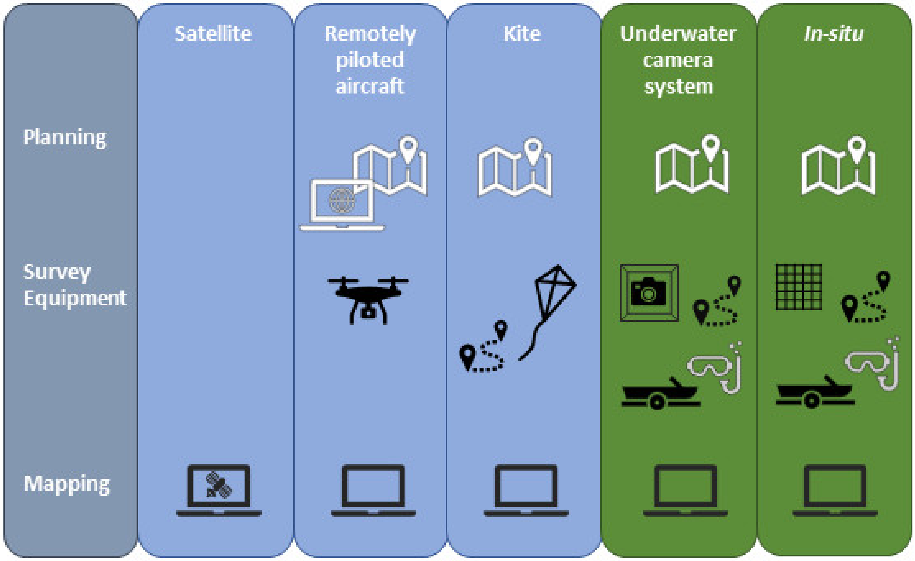
2. Seagrass Monitoring Tools

Seagrass is monitored using remote sensing supported by—or alternatively—in situ surveys. Here, we define remote sensing in its broadest sense as any technique that collects data at a distance from a feature without making direct contact (note that, under this definition, some remote sensing techniques require deployment of equipment at or near the focal location), and in situ as techniques that require contact with the feature or data collection in the direct vicinity (e.g., the use of quadrats, standing within a seagrass bed or scuba diving directly above it). One of the main differences between the two approaches with respect to mapping seagrass is that in situ surveys commonly gather information from a set of points within a seagrass bed and interpolate to the whole feature or track the boundary of the feature, while remote sensing techniques are generally aimed at mapping the features in their entirety (Figure 1). There are general advantages and disadvantages to both approaches, summarised in Table 1.

2.1. Remote Sensing Techniques

Remote sensing aims to directly map the entirety of a seagrass feature. Remote sensing-based tools and methods have been applied for mapping and monitoring seagrass habitats worldwide since the end of the 1990s and have proved to be an effective means to map systems at both local and regional scales [21]. A variety of techniques are available for remote sensing, ranging from aerial methods that can be applied on a regional to local scale, to in-water technology that uses either standard imagery or acoustic signals to identify and map the seagrass at specific locations (Table 1).
The aerial methods mainly all have the same underlying purpose—interpretation of the visible bands from stills or video imagery in various forms to classify and quantify the extent of seagrass in an area (though topographic and airborne bathymetric LiDAR uses laser pulse reflections [27]). The main differences between the techniques are in the scale over which they can be applied and the accuracy and precision with which they can be used to map the features. Satellites and crewed aircraft are effective in mapping over large scales (see overview in [21]) but they are less accurate than remotely piloted aircraft (RPA) or kites, which offer high resolution mapping but are more amenable to mapping small areas [28]. Large RPA exist that are more akin to crewed aircraft; however, here, we focus on the small fixed-wing or rotary craft commonly used in environmental monitoring. Bathymetric LiDAR sensors are also being developed for deployment on smaller RPA (see [29] and references therein), but it is too early to understand their utility for seagrass mapping. Ground-mounted terrestrial LiDAR has also been used in seagrass beds, but since the applications use topography as a proxy for seagrass or to feed into habitat suitability models rather than map seagrass per se, we do not consider them further here [30,31].
Underwater imagery encompasses camera sensors of several types mounted on a variety of equipment, from simple systems used to collect ground-reference data through to underwater vehicles used for whole-feature mapping [32,33,34]. It is similar in principle to aerial imagery, but has the advantage of being closer to the bed so as not to suffer from aerial visibility issues (e.g., cloud, fog and glare). It is, though, also limited by light attenuation and water clarity, and can be complicated and expensive depending on the system used. Like RPA, mapping with underwater camera systems does appear to be capable of using photogrammetry to provide high-resolution 3-D representation of seagrass beds [35]. Acoustic technology (side-scan sonar or multibeam echosounder), which uses the intensity of reflected sound (backscatter) to map seagrass [36], can produce high-resolution data giving complete coverage of a surveyed feature. Acoustic techniques are not subject to the same limitations as the visual methods and so can operate in deeper and more turbid waters.

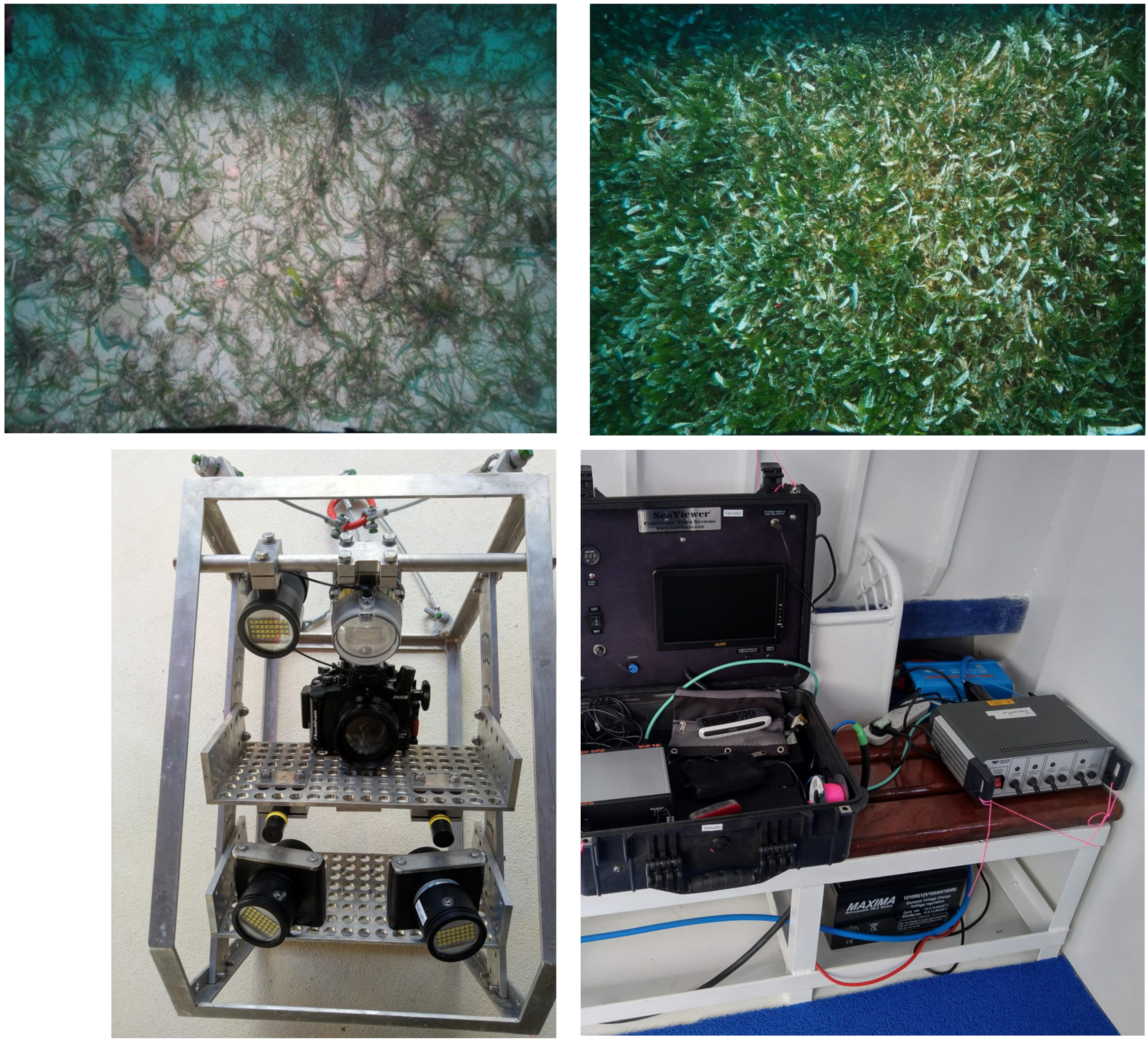
2.2. In Situ Techniques

In situ techniques are used for both the production of ground-reference data and direct seagrass mapping. Seagrass mapping and monitoring has traditionally utilised techniques such as boundary-tracking and grid, transect or random-quadrat surveys at individual sites or local scales (see, e.g., [37,38,39]) (Table 1). These methods allow rapid assessment of seagrass beds at multiple locations (e.g., [26,40]). Boundary-tracking involves traversing the outer boundary of the seagrass bed with a hand-held GPS system [41,42]. This is a simple and effective method, but it can be problematic on foot for subtidal areas; where boats are used to traverse subtidal portions of a bed, manoeuvrability may be an issue when trying to follow the boundary. Boundary-tracking is subjective in that decisions must be made on what constitutes the outer edge of the bed and, when the seagrass is sparse, this can be a difficult visual task. The technique also assumes the bed is internally homogenous; using the outer boundary to calculate areal extent will return an over-estimate for patchy beds.
Spot, grid, transect and random-quadrat surveys aim to map a seagrass bed by gathering information on seagrass species and density (often percent cover) at a series of points and interpolating information about the areas between them (e.g., [41]). The interpolated percent cover information can be used to determine the extremities and areal extent of the bed. This approach is better than boundary-tracking at accounting for patchiness within a bed, though it is less accurate at determining the outer boundary because it uses interpolation. The benefit of in situ mapping and monitoring approaches is that they are generally straightforward to learn, do not require complicated equipment and work well as citizen science initiatives [43,44]. In situ methods are the cornerstone of training and validation for remote sensing techniques [45].

3. The South Pacific Seagrass Mapping Toolbox

The Indo-Pacific region is a global hotspot of marine diversity [46] lying at the confluence of the Indian and Pacific Oceans, and encompassing the seas surrounding the Indonesian Archipelago, the South China and Philippine Seas, the north coast of Australia, Western and Central Micronesia, Polynesia and Melanesia.
This study details examples from Melanesia in the South Pacific Ocean and uses Guadalcanal and Efate, two of the main islands in Solomon Islands and Vanuatu, as case study areas. The Vanuatu Archipelago is a group of volcanic islands about 1800 kilometres northeast of Australia (Figure 2). It comprises six provinces with the capital Port Vila located on the island of Efate. Solomon Islands is a sovereign country that consists of 6 major islands and over 900 smaller islands, with the capital and largest city, Honiara, located on the island of Guadalcanal (Figure 2). Efate and Guadalcanal have total land areas of 898 km² and 5302 km², respectively, and present three different types of habitats typical of tropical seascapes: coral reefs, mangrove forests and seagrass meadows [47]. Nine species of seagrasses have been identified in Solomon Islands, and thirteen in Vanuatu [11]; however, the spatial distribution and areas of seagrass meadows is currently unknown in both islands. Anthropogenic pressure is mainly related to agricultural, sewage and industrial inputs into the coastal zone, logging and/or mining and accompanying water quality issues (e.g., [48,49,50,51]).

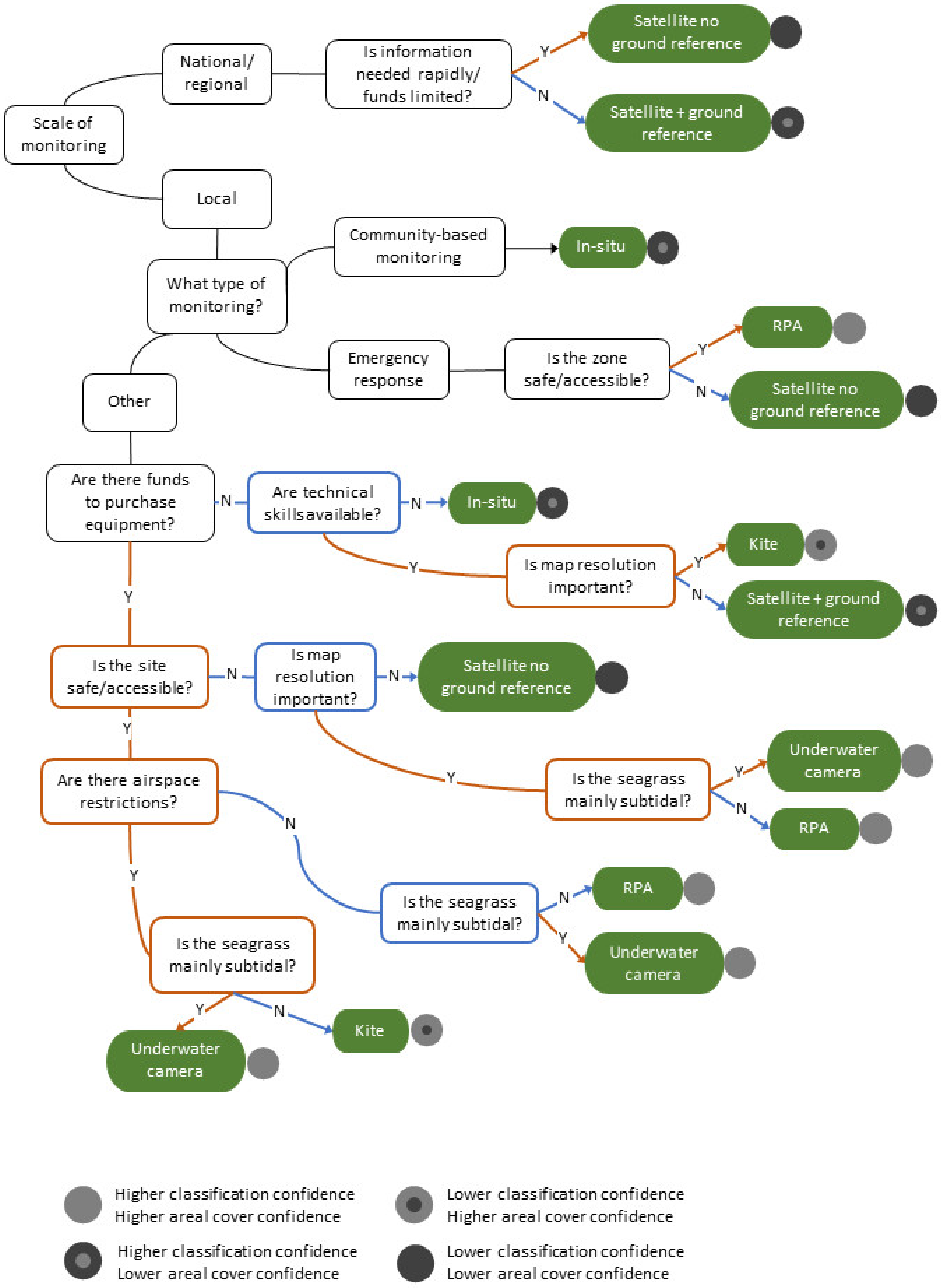
3.1. Selecting Tools

We devised a set of criteria relevant to monitoring seagrass in data-poor South Pacific environments. The five criteria are:
  • Spatial scale and resolution. Tools that map larger scales can fill data gaps quickly and effectively. Mapping over large spatial scales often means mapping at low-resolution, which can come at the cost of accuracy, thus mapping at smaller scale is important in the context of monitoring change at specific locations.
  • Cost. Large Ocean States can be economically disadvantaged compared to more prosperous nations, with comparatively smaller budgets to spend on ecological monitoring, and so decisions should consider the economic cost of purchase and ongoing maintenance of equipment and of technical training).
  • Maintenance and storage. Some of the monitoring techniques use tools that require little in the way of maintenance, but others are complex pieces of equipment requiring calibration, a power source, ongoing maintenance and troubleshooting. If survey teams lack the necessary skills, support, storage space or means to purchase replacement components, this equipment can become a burden.
  • Expertise. The level of expertise needed to operate monitoring equipment and undertake mapping processes is relevant to tool selection; the greater the complexity of the method, the greater the skills need and training burden.
  • Accessibility. Intertidal and shallow coastal environments can be unsafe places to access for surveying and water safety is of particular concern in nations where swimming skills are not widespread (Udagedara, S., Blue Resources Trust Sri Lanka; pers. comm.). Moreover, the South Pacific is made up of thousands of small and isolated islands.
The monitoring tools were appraised relative to each other against the five criteria (Table 2). Scale is subjective and rather arbitrary; here, we have loosely defined it as the spatial scale at which the tool could be expected to produce data during a reasonable survey window. Satellites orbit the globe in quick-time (e.g., the European Space Agency’s Sentinel-2 satellite completes an orbit in 100 min [52] and, thus, can easily provide data at the national to international scale. Crewed flights can cover areas from 5–500 km2 up to around 6000 km2 while RPA, in comparison, generally covers up to few km2 per flight [53,54].
Crewed aircraft perform quite poorly, scoring high for three of the five criteria; while they do offer advantages in providing large-scale data and are well-placed to reach and survey isolated inaccessible locations, crewed aircraft surveys may be prohibitively expensive whether contracting a specialist flight operator or purchasing a dedicated aircraft and/or sensor equipment. Similarly, underwater acoustics also score high for three of the criteria; it is a well-established method for mapping seabed habitats, but the specialist equipment required makes it a more costly option compared to other remote survey techniques. It also requires deployment from a vessel, and operating equipment from vessels at sea adds safety risk and further cost. In addition, operating the equipment and processing the data both require specialist skills that may not be easy to obtain and maintain in survey teams. We, thus, reject both tools from inclusion in the toolbox due to their combination of high cost, maintenance or expertise required relative to the other tools.
The remaining techniques can be considered useful in South Pacific contexts when considering our governing principles of applicability to the requirements of isolated locations and ongoing practical usability. The tools retained for the mapping toolbox are thus: satellite, RPA, kites, underwater camera systems and in situ surveys. Of these, the RPA and underwater camera systems do require piloting skills; however, with the broad availability and application of RPA for environmental monitoring, equipment can be relatively cheaply obtained and novices can be trained in piloting and basic image processing in around a week [55]. Likewise, an initial investment in skills development is needed for data processing and analysis associated with mapping for all four remote sensing tools. This is particularly the case when more advanced methods such as Object-Based Image Analysis or Deep Learning are used [56]. Basic data processing and vegetation demarcation can, however, be undertaken on images with relatively little technical skill, and online/self-teaching resources are widely available. The toolbox is shown in Figure 3. The most pre-planning is generally required for RPA mapping, which uses dedicated software for flight-planning and can require airspace permissions. Some planning is also required for kite, underwater camera and in situ surveys. Underwater camera systems and in situ surveying may require the use of snorkel or dive equipment and vessels.

3.2. The Toolbox Decision Tree

The key driver in the selection of seagrass mapping tools is to consider the objective of the monitoring. Rather than considering the type and purpose of monitoring at the tool selection stage, we incorporate it into the decision tree. The purpose of the decision tree is to provide planners and practitioners with a simple method of selecting the most useful seagrass mapping technique for bespoke monitoring. The options included in the tree relate to real-life scenarios we consider to be most commonly encountered when planning a monitoring initiative. These come from our collective experience of mapping and monitoring in the region and more broadly, as well as local feedback from managers and practitioners. They are encapsulated in the following six drivers:
  • the size and accessibility of the area to be mapped;
  • the purpose of the mapping;
  • the speed with which the information is needed;
  • the finances available for monitoring;
  • the skills and experience of the monitoring team;
  • the accuracy and level of detail required.
The decision tree is provided in Figure 4, beginning with the scale of monitoring required and then considering the other drivers. Some additional drivers are employed when the tree nodes lead to two similar tools, such as considering airspace restrictions for RPA or whether mapping intertidal or subtidal seagrass beds when choosing between kites and underwater cameras. The tree is specifically designed to pose predominantly yes/no questions in order to allow tool selection to be undertaken by users across a range of background expertise. The qualitative questions allow users with less technical expertise to progress through the tree, while some nodes can be expanded into quantitative questions if users desire—for example, when considering priorities for map resolution.
Several different tools are suggested for monitoring at the local level, but only satellite monitoring is recommended as the main mapping tool at the national and regional scale. Ground-referencing is recommended in all but a couple of specific situations. Ground data are needed to train and validate the remotely sensed maps, and are traditionally obtained by in situ survey. Some remote sensing tools are now also used to provide ground-reference data for other tools, for example, RPA or underwater camera images used as ‘ground’ reference for satellite mapping; there are pros and cons to this, since the images they provide must themselves be interpreted.

3.2.1. National and Regional Monitoring

Examples of where national or regional (sub-national, e.g., large embayments, long stretches of coast or whole provinces) monitoring may be desired include selecting locations for marine conservation initiatives and estimating seagrass carbon storage for climate mitigation (e.g., Coral Triangle Marine Protected Area Network [57], iKiribati Nationally Derived Contributions [58]). The choices here are whether whole-country maps are required in a short timeframe—in which case, they can be produced without the use of dedicated reference data (or using existing data collected for other purposes [59])—or whether there is sufficient time and funding to undertake a dedicated ground-reference exercise. Mapping without ground validation will necessarily be less robust than that derived using ground-reference data. Mapping at the national scale can also function as a means to select sites for monitoring at the local level, depending on the needs of the programme. Satellite usage also lends itself well to mapping across international boundaries.

3.2.2. Local-Scale Monitoring

When monitoring at the local level, the initial question relates to finances. If funding is limited, the question becomes one of the technical skills available within the monitoring team (i.e., data processing and primarily GIS mapping), or its ability to develop them. Where there is little funding and technical skills are limited, in situ monitoring is recommended. Where there is little funding but the responsible agency has GIS mapping skills, the recommendation is for kite surveys; otherwise, satellite mapping.
There are more options when financing is available to purchase higher-value survey equipment. In these situations, the accessibility and safety of the survey site becomes an important question; if there are concerns over the safety of the specific location or it is inaccessible—for example, if it contains extensive muds, is proximal to crocodile habitat [60] or is very remote—then RPA, some forms of underwater imagery and satellite are recommended. The choice between these is determined by whether high-resolution mapping is required and whether the seagrass bed is predominantly subtidal. Satellite is generally only recommended when resolution is not a key driver for the monitoring, although high-resolution satellite imagery is becoming more widely available for these purposes (see, e.g., 25). Underwater cameras may be more useful than RPA for subtidal monitoring since they avoid issues of surface glare. Kites are not recommended in reduced-safety sites because kites require the survey team to walk amongst the seabed features to capture the images, while RPA can be flown from a location set back from the site and underwater cameras can be deployed from boats.
For accessible locations, RPA, underwater imaging systems and kites are all options, the choice depending on whether there are airspace restrictions over the location to be monitored and whether the seagrass bed is intertidal or subtidal. We recommend aerial methods over underwater cameras where parts of the seagrass bed are intertidal, since this gives more flexibility in survey timing.
There are two special cases for local monitoring. Citizen science initiatives transcend questions of finances or technical skills. In the case of developing community-led monitoring initiatives, we advocate in situ techniques in the first instance irrespective of funding, because successful programmes are already in place in the region that demonstrate the benefits to be achieved both scientifically and societally, and the data they generate can feed directly into local traditional management, which is important for South Pacific cultures (e.g., Solomon Islands [61], Vanuatu [43], Torres Strait, Australia [62]). RPA also lend themselves well to community monitoring, though the equipment needs more upkeep and the initial training is more involved. The second special case is urgent or emergency response monitoring, where remote sensing can be used to provide information on environmental impacts of incidents relevant to Pacific Island states such as oil spills, tsunamis or cyclones (e.g., [63]). The primary determinant here is safety; if the location is accessible or safe to enter, RPA monitoring can obtain a rapid high-resolution overview of the situation. Where access is not possible, the location is unsafe or the situation affects a large area, satellite mapping is to be preferred.

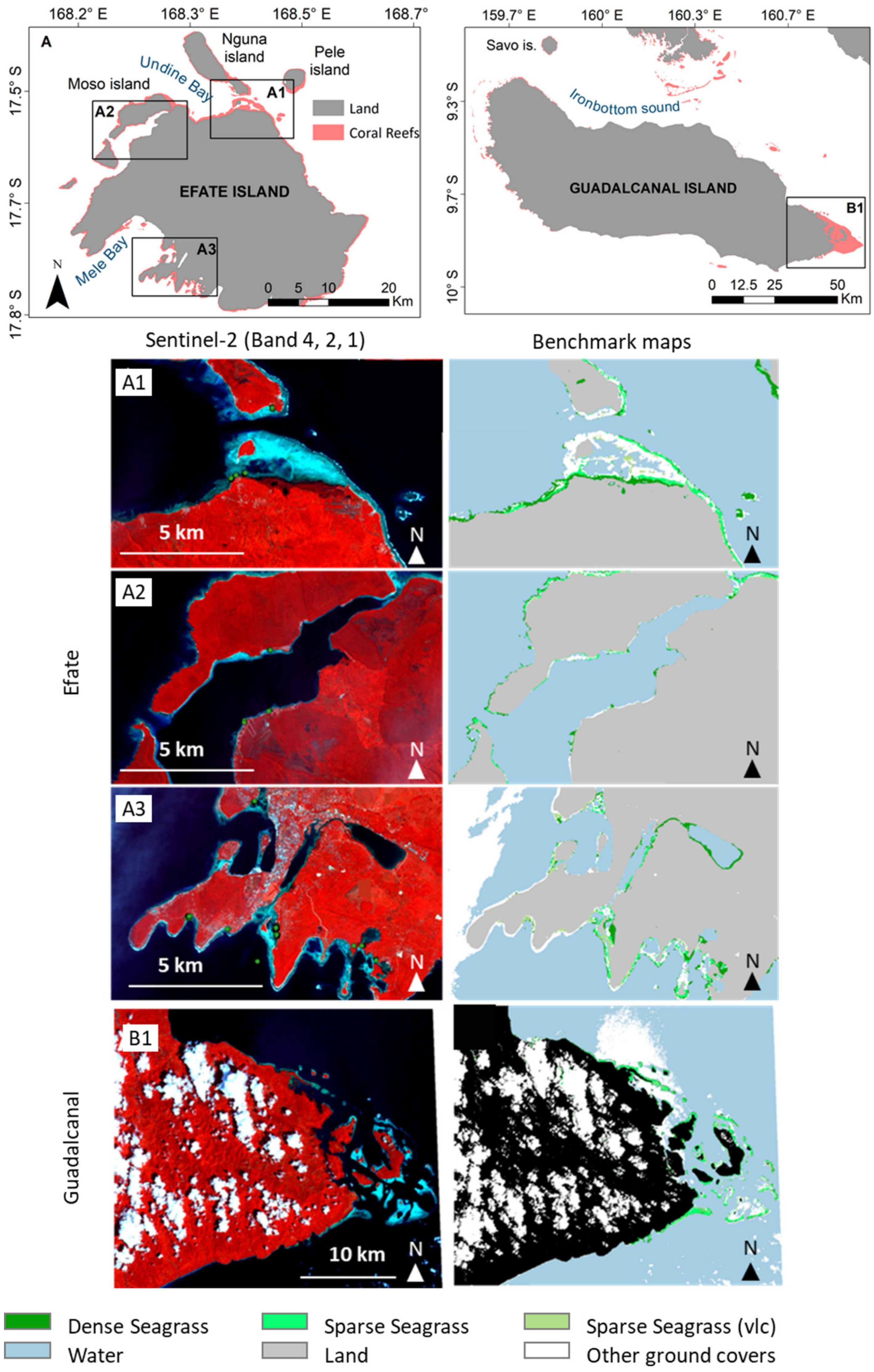
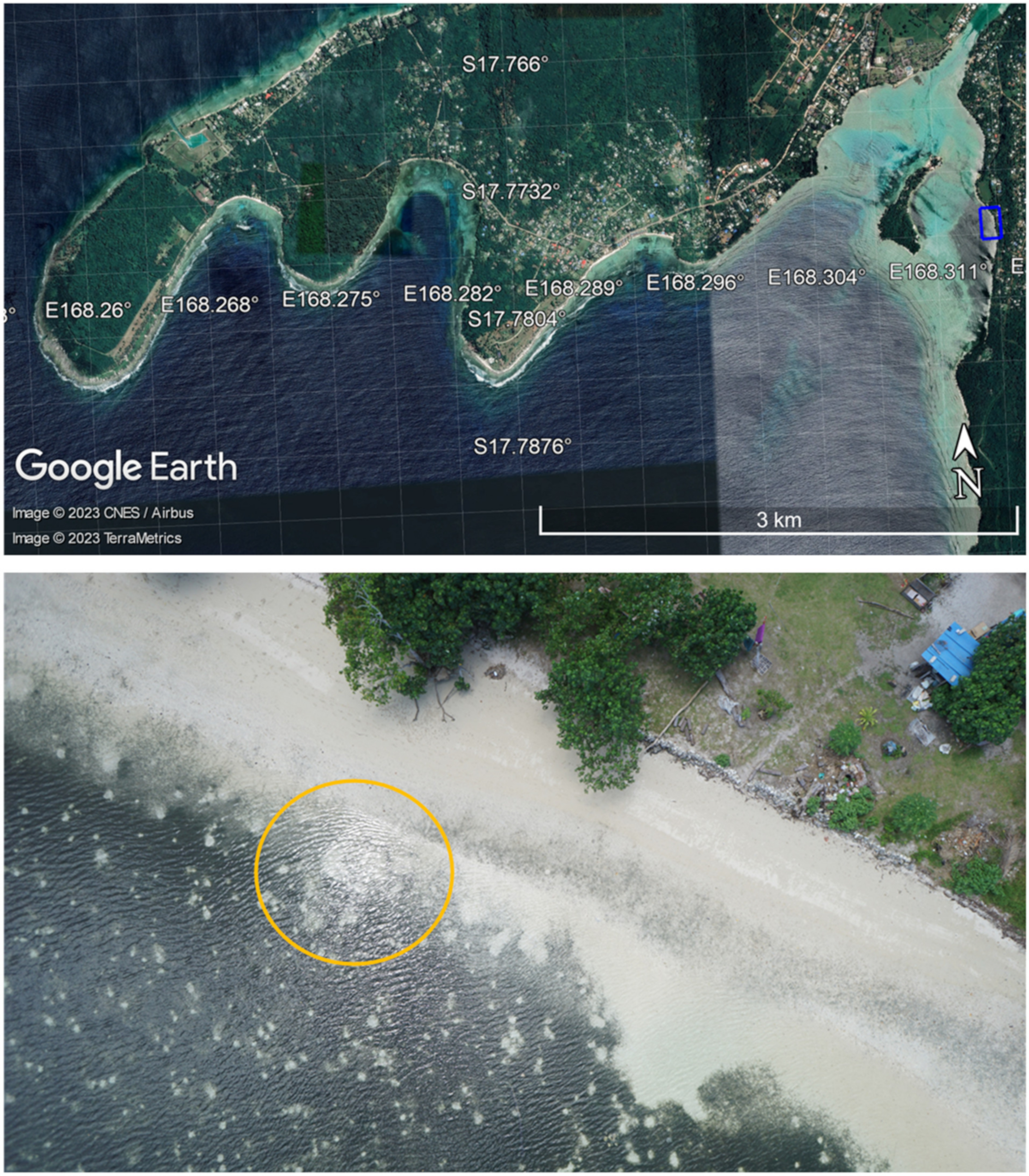
3.3. Example Application of the Tools

Here, using Solomon Islands and Vanuatu as case study areas (Figure 2), we provide three pertinent examples to illustrate the opportunities for applying the toolbox to real-world data-poor situations. We look at (i) completely remote applications (satellite mapping with little ground-reference data), (ii) high-resolution aerial and underwater systems and (iii) in situ citizen science monitoring.
Our first application of the toolbox exemplifies how satellite mapping can perform in less-than-ideal situations. Here, the Commonwealth Marine Economies Programme assessed the use of satellite data to produce the first (to our knowledge) rapid full-coverage seagrass maps for Guadalcanal and Efate, two of the main islands in Solomon Islands and Vanuatu and home to the nations’ capitals (Figure 5). The maps were required over a short time frame (1 year) with insufficient funds to commission full ground-reference surveys.
Both maps were derived from Sentinel-2 data (November 2017 for Guadalcanal and October 2018 for Efate), employing an iterative mapping framework derived from the BioCoast project (Figure A1). The BioCoast project aims to develop a next-generation methodological protocol combining field and satellite data, and is being trialled at several test sites in Europe [64]. The Framework was adjusted for the data-poor Pacific context and example applications of the framework as part of CMEP are outlined in Figure A2. The classification was performed in QGIS using a random forest machine learning model. There is a paucity of contemporary in situ seagrass reference data for both islands, a common problem for South Pacific Large Ocean States [20]. Thus, for Guadalcanal, we investigated the use of historical calibration data [26], and for Efate, we undertook an expert judgement calibration exercise using photo-interpretation that employed informal knowledge of local seagrass presence. Detailed methods are provided in Appendix A. It is acknowledged that these maps are not of a standard that would be expected from a complex mapping and modelling process supported by extensive reference data and they are not to be used for operational purposes. Their purpose is to illustrate what is possible in terms of producing initial basic maps at large spatial scale, with accompanying confidence assessments, in data-poor situations where funding is a limiting factor. Such maps can serve to guide further investigation at the local level, e.g., in identifying locations for detailed survey and providing initial estimates of seagrass presence in remote locations. Additional reference data (expert contributions, new field datasets or other (higher-resolution) spatialized information on ground covers) must be added in the future in order to train and evaluate the supervised model iteratively until a seagrass distribution map with a sufficient level of confidence is obtained.
Our second example illustrates the potential for application of remote aerial and underwater tools in the two nations. Figure 6 shows imagery from a trial RPA seagrass survey undertaken by the Vanuatu Department of Water, Geology and Mines and CMEP in Erakor Lagoon, Vanuatu. The flight was conducted during low tide, at around midday, on Friday the 16 March 2018, using a DJI BOT rotary RPA equipped with an RGB camera; the orthomosaic was produced using Pix4D. This example demonstrates both the potential and constraints of RPA for seagrass mapping in these types of environments. The individual images show the detail with which seagrass can be mapped; the vegetation can be clearly distinguished and image quality and resolution are sufficient to show the small circular clearings within the bed made by benthic fauna. The orthomosaic (Figure 6) shows the effect of surface glare on image quality; reflection from the water surface will impair the ability to accurately classify seagrass and subsequently artificially deflate extent calculations, an issue particularly pertinent to sunny tropical climates. Glare issues are surmountable [65], though RPA flights work best in lower-wind, less-bright conditions.
Figure 7 illustrates a bespoke underwater optical shallow-water drop camera system designed for use in tropical coastal waters, deployed by CMEP as part of a local stakeholder seagrass survey training workshop in Erakor Lagoon, Vanuatu in June 2019. This surface-(battery)-powered system is deployable by hand to depths of ~100 m (operational limit), and comprises an HD video system with surface feed, standalone digital still camera, LED lighting and laser scalers. As Figure 7 shows, these types of system perform well in surveying clear South Pacific coastal waters and their comparatively small size make them well-suited to small-boat surveys of nearshore seagrass and situations where safety or logistic concerns limit ingress to the water. Drop camera systems would benefit from further testing in Pacific conditions as a means for relatively quick data collection; however, in this form, the drop camera is better applied to collect ground-reference data than for comprehensive mapping and both need a reasonable level of training and expertise for equipment operation and data analysis.
Our final example is of successful implementation of in situ citizen science approaches in the region, by way of the Tetepare Descendants Association’s use of the Seagrass Watch [66] protocols to monitor seagrass beds within the Tetepare Marine Protected Area in Western Province, Solomon Islands [61]. A local, female-led initiative focusing on gender empowerment, the project—monitoring via the placement of random quadrats—has provided both baseline information on the status of the seagrass beds in an otherwise data-poor province and data that can be employed to track and understand the impacts of Pacific-relevant stressors; in this case, the impacts of a large earthquake and tsunami that occurred in the province in 2010. The monitoring timeseries was disrupted on several occasions due to financial constraints, illustrating one of the challenges associated with maintaining in situ timeseries, even when citizen-science-driven. Nevertheless, it is an important data source at both provincial and national levels. Data from local initiatives such as these can also be used as ground-reference data to furnish broader mapping via remote sensing.

4. Discussion

The monitoring toolbox can support decision-making when embarking on monitoring initiatives for data-poor situations in Pacific Large Ocean States. It aims to provide a pathway that allows selection of useful tools for seagrass monitoring; however, it is important to state there is no ‘perfect’ approach, simply a range of tools that may be more or less helpful in particular circumstances. Indeed, the best approach in terms of data quality may be to use more than one tool (e.g., in situ and underwater camera mapping; see [41]). Combining multiple tools gives data richness, increases ground coverage for mapping, can be useful to consider where multiple methods have been used in the past or where seagrass beds straddle shallow-to-deeper waters and provides vital validation data to improve the accuracy of lower-resolution satellite maps. For example, [67] used satellite, acoustics, RPA, an automated surface vehicle and an underwater towed camera system together with multiple classification algorithms to improve on satellite map resolution of seagrass from the intertidal to ~41 m depth. The toolbox provides options for different situations and these can be used singly or in combination; it is worth considering, though, that using multiple tools can become complicated and technically challenging; in these circumstances, care should be taken to consider data comparability [24,68]. There is a trade-off between data accuracy and practicality; the range of classification algorithms available for mapping seagrass adds further decisions on top of the survey tools and we recommend that complex methodologies such as that used by [67] are only adopted where the monitoring team is confident and experienced in the equipment usage and data manipulation of spatial analysis.
The scale over which the monitoring is needed is an initial determinant of tool selection. For all but the very smallest of states, creating full-coverage national maps using RPA, kites, underwater imagery or in situ surveys is unrealistic due to the time and expense required to access and survey all sites, and satellite is, in our opinion, the only viable option. Satellite imagery can provide good resolution for mapping of seagrass at this scale, provided that the requirement for validation can be resolved through aligning some aspect of ground-reference data collection (or lower confidence acknowledged where use of ground data is not possible). Satellite imagery has advantages in terms of coverage, with, in our Vanuatu and Solomon Islands example, Sentinel-2 example imagery having some ability to differentiate dense and sparse seagrass classes and seagrass bed classes from the other substratum classes (Figure 5 and Appendix A). The resulting meadows mapped from the Sentinel-2 images were not precise and did not allow the differentiation of species. They were, thus, successful at providing information at the national scale, but with low-accuracy and low-confidence. Recent advances are resolving some of these issues. PlanetScope satellite imagery, with a 3.7 m × 3.7 m pixel size, RGB spectral bands and daily revisit time at nadir are now freely available via the Education and Research Program. They have been used to map global reef regions, including seagrasses in the Pacific (25). This type of very-high-resolution satellite imagery, combined with emerging classification techniques such as Deep-Learning or Object-Based Image Analysis, will be fundamental in providing greater-resolution and more-accurate satellite maps in the future that can be used to inform management priorities at national, but also local and global, scales. In the case where no (or very few) field survey data are available, expert or community contributions can aid in training classification models and evaluating their performance, adding at each step expert knowledge, new field data or other (higher-resolution) information on ground features. Citizen science and multi-partner networks are a great way of collecting observational information in large remote areas and engage local communities in mapping and conservation actions. The emergence of phone apps and web mapping are facilitating the collection, storage and visualisation of collaborative information, though these projects must have long-term financial support to operate successfully.
Nested within national and regional mapping is the suite of tools for mapping and monitoring change at the local level. These serve to generate more accurate, fine-scale monitoring data at specific locations and often function also as ground-reference data for satellite maps. The tools can provide data at the cm to mm scale, meaning they can be used to monitor for short-term or subtle changes in seagrass beds, providing the possibility to monitor very localised effects such as anchor damage (note the ability of RPA to image the round pits made by small invertebrates in Figure 6). Site-specific monitoring may be desired for a number of reasons, including impact assessment and post-construction monitoring for developments built on or near a seagrass bed, pollution assessments or blue carbon assessment. Successful monitoring considers the specific purpose of the work and the team’s skillset, and selects tools accordingly. Clarity of methodology and justification of the selected tools is important. For example, [69] used RPA to map seagrass extent in their blue carbon survey but also used walk-round and video data to quantify the boundaries of the seagrass beds; it is unclear why two separate methods of area mapping were used and if or how the data were combined, which somewhat reduces confidence in the presented outputs. Where time and resources permit, the lower-resolution national and higher-resolution localised approaches align well; national mapping provides a broad overview of the seagrass resources, while the other tools give ground-reference data to train and validate the satellite outputs and provide more detailed monitoring and potentially species-level identification at locations of particular interest. We advocate this approach of lower-resolution national mapping combined with high-resolution local site mapping, where possible.
Undertaking satellite mapping without ground-reference data is likely controversial to some, but we argue that it can be useful and is a realistic proposition in some circumstances. The case of seagrass monitoring in Brazil provides an illustrative example. In 2019 an oil spill disaster occurred along the Brazilian coast in areas populated by seagrass and mangroves [70]. The onset of the COVID-19 pandemic suspended the response activities that had only just begun, thus preventing the collection of survey data to assess the distribution of the oil and its ecological impact on the seagrass. Satellite mapping in this circumstance, even without ground survey data, would have allowed for an initial assessment of the extent to which the oil intersected with the seagrass resources. Indeed, the benefit of this approach is that (i) it is not time-limited and can still be attempted since the satellite images will remain available and (ii) combining historical and more recent satellite imagery would allow before–during–after comparisons. Confidence in such maps will of course be much lower than maps generated using ground data; however, as in the Brazilian example, they would produce some quantitative information in data-limited areas and accompanying confidence assessments can be produced to aid interpretation.
We consider it best practice for ongoing monitoring to continue using the same tool that was used to create the baseline data in order to support data harmonisation. However, circumstances do not always permit this and some tools can, to an extent, be substituted if necessary; for example, where certain equipment is already owned by the monitoring team, where new equipment being purchased is required for multiple purposes (e.g., RPA destined for seagrass mapping but also for coastal erosion monitoring or disaster response work), equipment breaks down and cannot be quickly or easily replaced or if ground conditions render the previous method ineffective (e.g., aerial methods may fail in very turbid waters after extreme weather events, but underwater cameras may provide usable imagery).
Kites and RPA are relatively similar in application and somewhat interchangeable. RPA are generally a better choice because they have superior navigational control, making it easier to keep them on course—important for image stitching and to minimize variations in ground resolution between images—and reducing the likelihood of having to re-fly the site [28,71]. RPA also require less access to site than kites; RPA can be flown from a secure location behind a shore, while kites require the pilot to walk amongst the features being surveyed. Kites have the advantage of lower upfront costs and a lower training burden for piloting, though the skill level for image processing is the same for both and both can suffer from problems mosaicking over water due to image distortion and a lack of automatic tie points [65,72].
Where the survey team is confident in seagoing safety, underwater cameras may be preferable to RPA or kites in locations where flights are logistically challenging, unsafe to access or where persistent low water clarity hampers aerial imagery, though RPA is likely a better option in situations where very strong currents and/or the presence of underwater obstacles (e.g., Pacific War remnants [73]) could snag and endanger equipment and the deployment vessel. Underwater imagery is often used to provide ground-reference data for classifications derived from other remote sensing tools, but it can be applied to quantitative mapping of photo-mosaics [32]. Downward-looking uncrewed surface vehicles that can house more-accurate positioning systems than fully submerged cameras and can be run remotely from shore are showing promise for benthic flora mapping in shallow waters [34]. Because these systems move with the surface, changes in water depth across the survey area need to be considered, since differences in light attenuation can affect colour representation across images, with implications for habitat class-definition [34]. Such environmental challenges are common; however, remote sensing and surface/underwater camera technology is evolving to resolve them. In time, both fully submerged and surface-mounted underwater camera systems will become important tools for mapping at the whole-feature scale.
The development level of the various methods is relevant to tool selection. In situ surveying is very well established and remains fundamentally important to confirm the mapping accuracy of the other tools and to foster civic involvement in marine monitoring—one of the key benefits of in situ monitoring is community engagement, and it has clear utility for South Pacific applications [43]. Satellite mapping is also well-established, with an extensive literature (a Web of Science search for “seagrass mapping satellite” in the last 5 years returned 120 articles (at 11 April 2022)). RPA is comparatively new, as is modern semi-autonomous or autonomous underwater imagery, so while these topics are developing at pace and publications are blooming, there are still questions over how well they work in different situations, and there are currently fewer reference works available to mappers than from the satellite-based seagrass literature.
In developing this seagrass monitoring toolbox, we have followed the principle that some imperfect information is always better than none. Pacific Large Ocean States have enormous marine resources, some of which, such as seagrass, remain in impressive condition [20] but are overall not well-understood and face pressure from multiple human-driven problems. Time is of the essence in mapping the resources, as states face decisions that pit development, housing and food security needs against conservation priorities. Provided that suitable methods are used to estimate confidence for the outputs derived from the monitoring tools, we purposefully do not rule out methods that produce lower-confidence outputs such as satellite mapping without ground-reference data, or RPA or kite data lacking ground control points for accurate geo-referencing. Our toolbox is flexible and can be adapted to different circumstances, with tools selected from the box as desired to fit the needs of the monitoring and the skills, expertise and budgets available for the endeavour.

Author Contributions

Conceptualisation, J.B., M.J.D. and C.P.; methodology, J.B. and C.P.; formal analysis, C.P. and B.B.; writing—original draft preparation, J.B.; writing—review and editing, J.B., C.P., M.J.D., T.D., J.H. and B.B.; visualisation, J.B. and C.P. All authors have read and agreed to the published version of the manuscript.

Funding

The projects underpinning this work were funded by the UK Government Foreign, Commonwealth and Development Office (FCDO) under the Commonwealth Marine Economies Programme C7049.

Acknowledgments

The authors acknowledge Susana Lincoln of Cefas for her contributions to the training data for the Vanuatu satellite mapping project and the Vanuatu Department of Water, Geology and Mines for the Vanuatu RPA flight. We also thank the participants of the 2018 Dugong and Seagrass Conservation Project (DSCP) regional workshop on conservation of dugong and seagrass held in Munda, Solomon Islands, for sharing their views on Pacific seagrass monitoring, particularly Len McKenzie of James Cook University/Seagrass-Watch, Solomon Islands Ministry of Fisheries and Marine Resources and WorldFish Solomon Islands.

Conflicts of Interest

The authors declare no conflict of interest. The funders had no role in the design of the study; in the collection, analyses, or interpretation of data; in the writing of the manuscript, or in the decision to publish the results.

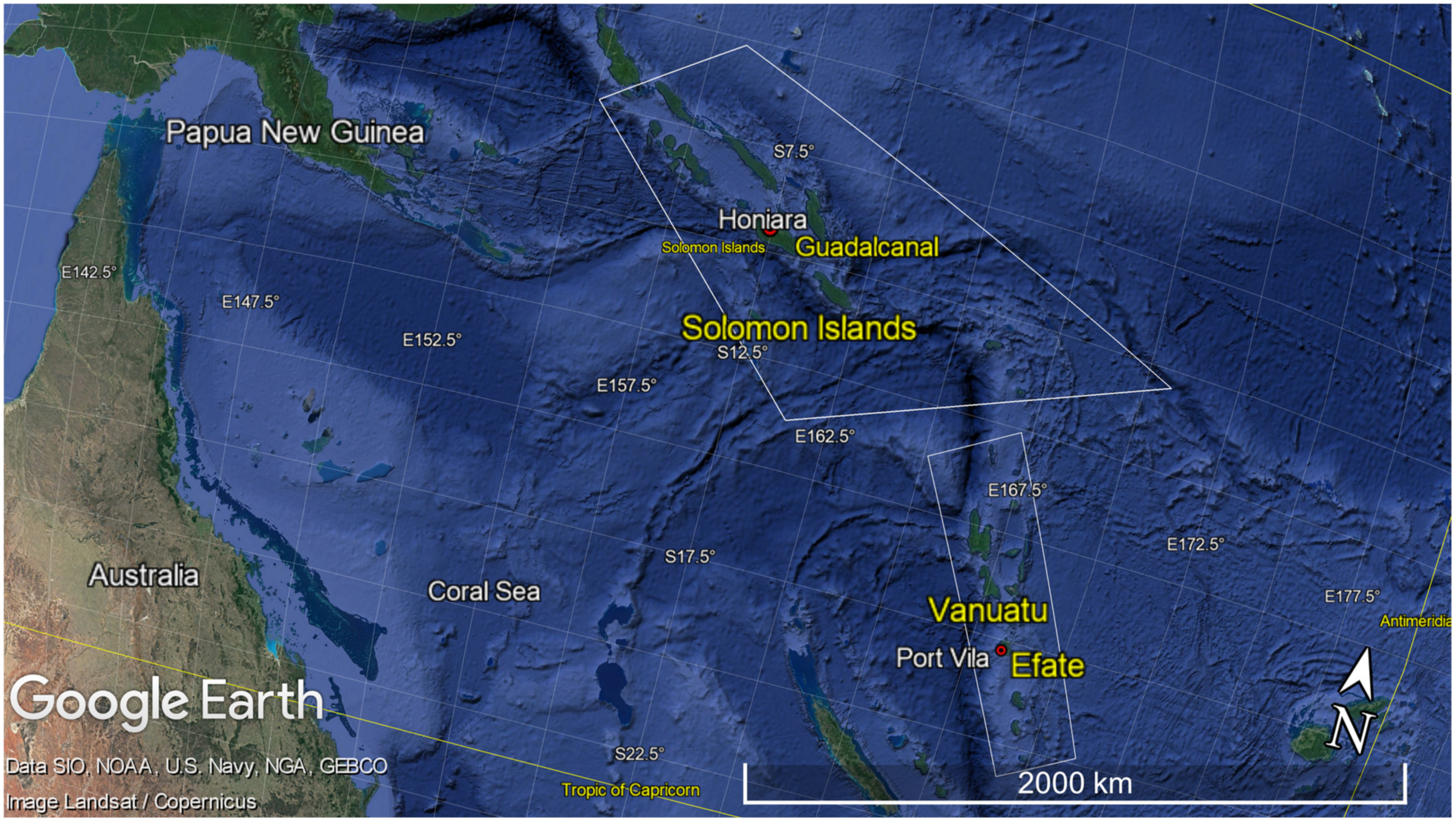
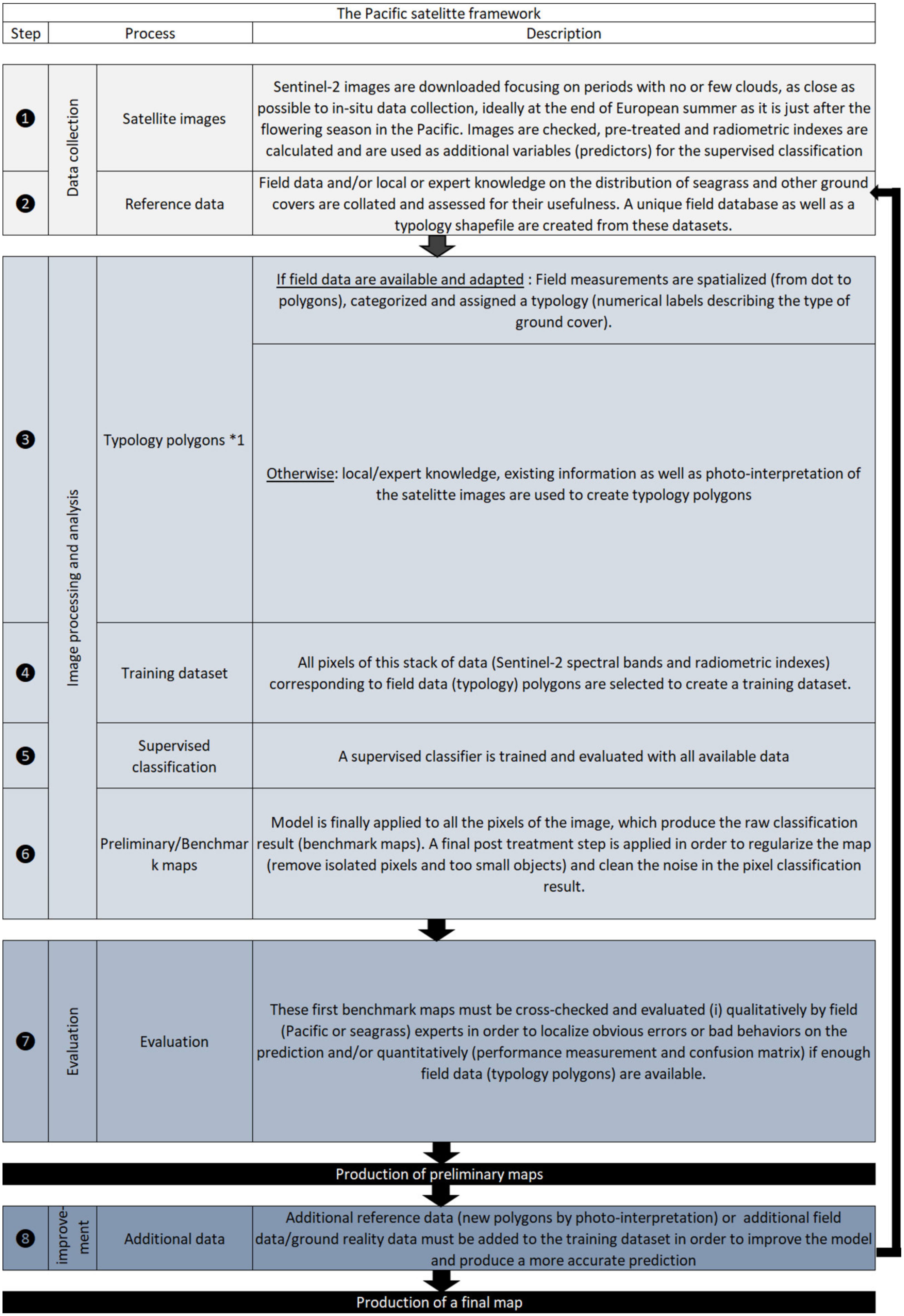
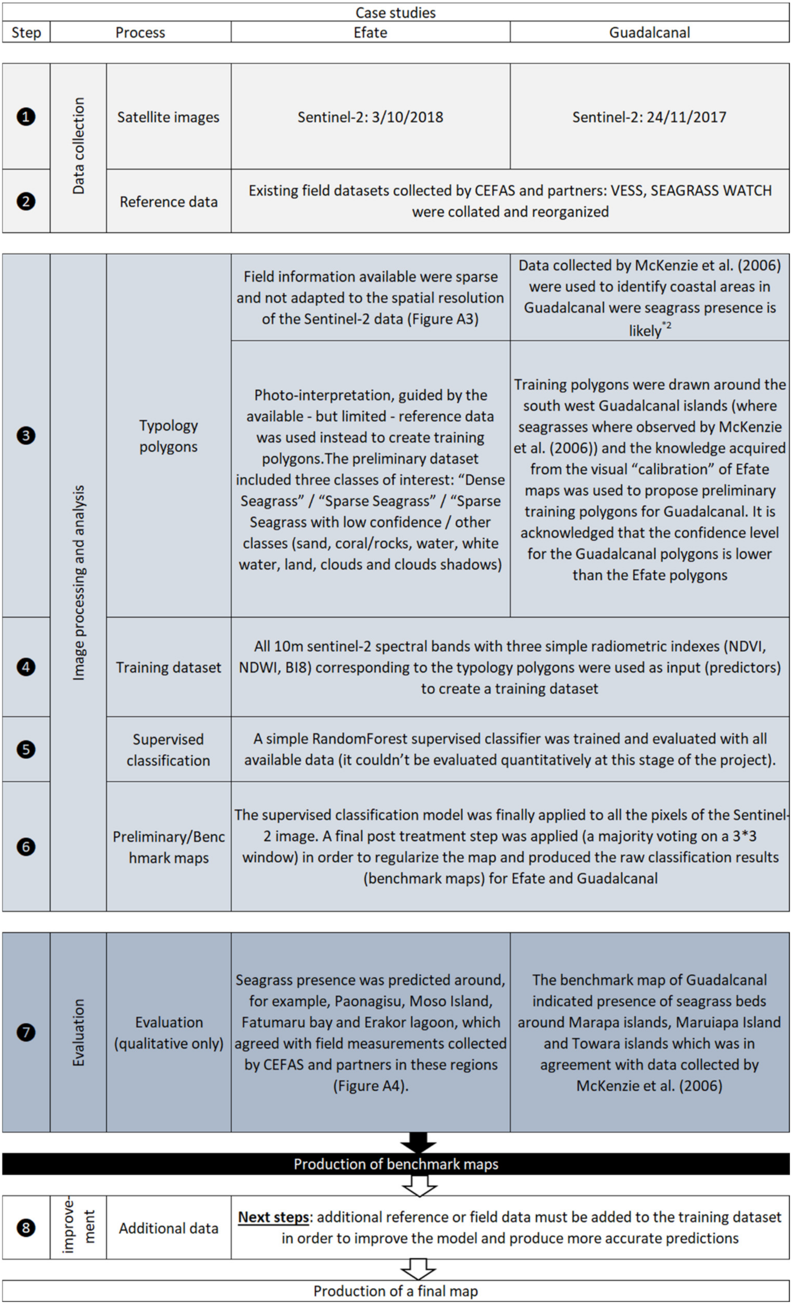
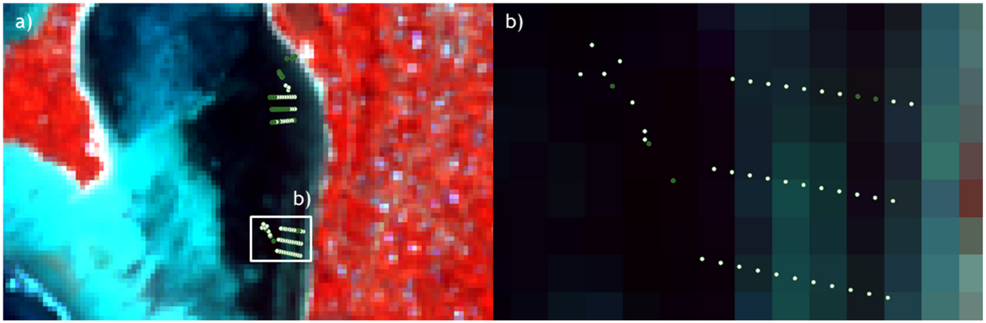
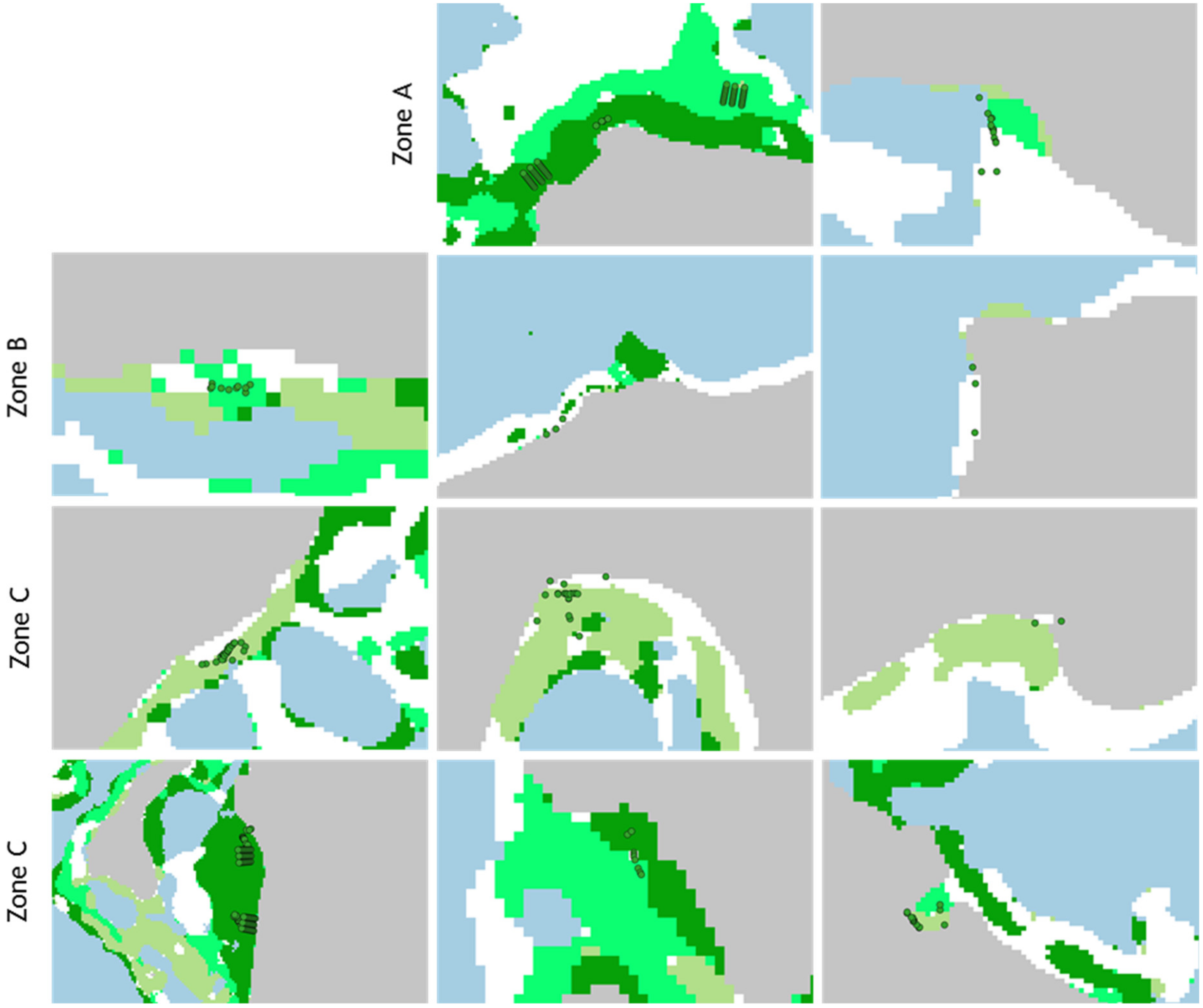
Appendix A. Satellite Mapping of Vanuatu and Solomon Islands

CMEP employed an iterative mapping framework derived from the Biocoast project [68] to undertake the seagrass mapping trials in Vanuatu and Solomon Islands. The predictive mapping process developed for Biocoast is a classic remote sensing processing chain. First, well-known radiometric indices such as NDVI are computed in order to give weight to the spectral response of chlorophyll activity and, thus, of vegetation. A photo-interpreted reference database is created by expert opinion. This database is the core of the supervised classification process. For each class of the targeted typology, a large number of polygons are produced, covering a maximum of variability for each of the targeted classes (in terms of intensity of the perceived spectral response, depths and with a good spatial distribution). All the original spectral bands and radiometric indices are then concatenated, and the reference pixels covered by the polygons of the reference database are extracted. A random selection of these pixels are then applied to form an independent training database and validation database. A random forest classifier is then trained and evaluated before being applied to the whole image. A slight spatial regularisation, using a majority filter of radius-2 pixels, is then applied to correct some of the classification noise. The quality of the prediction depends directly on the representativeness and relevance of the reference database produced.
Application to Vanuatu and Solomon Islands: In order to make a classified map showing seagrass presence/absence (and eventually classes of density), the supervised method developed requires data to train and evaluate a statistical model called a supervised classifier. The supervised method uses training polygons that identify distinct classes present in the satellite image of the study area, including seagrass beds. Based on spectral information from the training polygons, a supervised classification is applied to predict classes across the rest of the satellite image.
The result is a map where all pixels of the satellite image have been classified into different classes (or typology) defined by the training set. The classes (typology) are entities that need to be distinguished. They can be ground cover such as seagrass beds (dense or sparse cover), coral reef, rock, macroalgae or other features present in the satellite images such as clouds, cloud shadows, land and sea. As with any machine learning model, this supervised method performs better when a sufficient and representative training, testing and validation dataset is available. The amount of data required for the machine learning depends on many factors, such as the complexity of the problem (i.e., of the complexity and features of the landscape we are trying to map) and the complexity of the learning algorithm selected. However, a sufficient number of observations is needed to access the variance of each class (the possible variations for the same class).
The supervised processing chain is a key component of the learning process: information such as satellite radiometric indices, textural indices or additional features (predictor layers) are calculated prior to the machine learning step. The most relevant set of predictors can eventually be pre-selected to reduce the dimensionality of the problem.
The machine learning step is then applied (many supervised classification algorithms exist and can be tested depending on the factors defined above). It consists of training the supervised model and evaluating it iteratively, adding at each step: expert contributions, new field dataset or other (higher-resolution) spatialized information on ground covers. The model is trained, revised and evaluated again (v0, v1, v2 […], vx) until a seagrass distribution map with a sufficient level of confidence (qualitatively and quantitatively) is obtained.
The different steps of the method are outlined in Figure A1 and example applications are outlined in Figure A2.
Figure A1. The different steps of the Vanuatu and Solomon Islands mapping framework derived from the Biocoast project’s mapping process. *1 Typology is defined in this framework as classification according to general ground types. It is acknowledged that, at the Sentinel-2 pixel resolution (10 m), a respective ground cover type may correspond to mixed substrates.
Remotesensing 15 00834 g0a1
Figure A2. Example application of the mapping framework. *2 Acknowledging that seagrass location may have changed between the time this dataset was collected and this study.
Remotesensing 15 00834 g0a2
Figure A3. Illustration of (a) the resolution of the field data (typology shapefile created from the field information collected by Vanuatu Environmental Science Society, Cefas and Seagrass-Watch) vs. (b) the resolution of the Sentinel-2 image, Erakor Lagoon.
Remotesensing 15 00834 g0a3
Figure A4. Close up views of sites where seagrass beds have been observed in situ (green dots) overlaid with the preliminary classified (benchmark) map of Efate (zones A, B, C of Figure 5).
Remotesensing 15 00834 g0a4

References

  1. Fourqurean, J.W.; Duarte, C.M.; Kennedy, H.; Marbà, N.; Holmer, M.; Mateo, M.A.; Apostolaki, E.T.; Kendrick, G.A.; Krause-Jensen, D.; McGlathery, K.J.; et al. Seagrass Ecosystems as a Globally Significant Carbon Stock. Nat. Geosci. 2012, 5, 505–509. [Google Scholar] [CrossRef]
  2. Cullen-Unsworth, L.; Unsworth, R. Seagrass Meadows, Ecosystem Services, and Sustainability. Environ. Sci. Policy Sustain. Dev. 2013, 55, 14–28. [Google Scholar] [CrossRef]
  3. Nordlund, L.M.; Koch, E.W.; Barbier, E.B.; Creed, J.C. Seagrass Ecosystem Services and Their Variability across Genera and Geographical Regions. PLoS ONE 2016, 11, e0163091. [Google Scholar] [CrossRef] [PubMed]
  4. Costanza, R.; Limburg, K.; de Groot, R.; Farber, S.; Grasso, M.; Hannon, B.; Limburg, K.; Haeem, S.; O’Neill, R.V.; Paruelo, J.; et al. The Value of the World’s Ecosystem Services and Natural Capital. Nature 1997, 387, 253–260. [Google Scholar] [CrossRef]
  5. Brodie, G.; Brodie, J.; Maata, M.; Peter, M.; Otiawa, T.; Devlin, M.J. Seagrass Habitat in Tarawa Lagoon, Kiribati: Service Benefits and Links to National Priority Issues. Mar. Pollut. Bull. 2020, 155, 111099. [Google Scholar] [CrossRef] [PubMed]
  6. Marsh, H.; O’Shea, T.J.; Reynolds, J.E.R. Ecology and Conservation of the Sirenia: Dugongs and Manatees; Cambridge University Press: Cambridge, UK, 2011. [Google Scholar]
  7. McKenzie, L.J.; Yoshida, R.L.; Aini, J.W.; Andréfouet, S.; Colin, P.L.; Cullen-Unsworth, L.C.; Hughes, A.T.; Payri, C.E.; Rota, M.; Shaw, C.; et al. Seagrass Ecosystem Contributions to People’s Quality of Life in the Pacific Island Countries and Territories. Mar. Pollut. Bull. 2021, 167, 112307. [Google Scholar] [CrossRef] [PubMed]
  8. Trundle, A. Resilient Cities in a Sea of Islands: Informality and Climate Change in the South Pacific. Cities 2020, 97, 102496. [Google Scholar] [CrossRef]
  9. Dennison, W.C.; Orth, R.J.; Moore, K.A.; Stevenson, J.C.; Carter, V.; Kollar, S.; Bergstrom, P.W.; Batiuk, R.A. Assessing Water Quality with Submersed Aquatic Vegetation. BioScience 1993, 43, 86–94. [Google Scholar] [CrossRef]
  10. Waycott, M.; Duarte, C.M.; Carruthers, T.J.B.; Orth, R.J.; Dennison, W.C.; Olyarnik, S.; Calladine, A.; Fourqurean, J.W.; Heck, K.L., Jr.; Hughes, A.R.; et al. Accelerating Loss of Seagrasses across the Globe Threatens Coastal Ecosystems. Proc. Natl. Acad. Sci. USA 2009, 106, 12377–12381. [Google Scholar] [CrossRef] [PubMed]
  11. Brodie, G.; de Ramon N’Yeurt, A. Effects of Climate Change on Seagrasses and Seagrass Habitats Relevant to the Pacific Islands. Prof. Tech. Rep. 2018, 112–131. [Google Scholar]
  12. Duarte, C.M. The Future of Seagrass Meadows. Environ. Conserv. 2002, 29, 192–206. [Google Scholar] [CrossRef] [Green Version]
  13. Unsworth, R.K.F.; Cullen, L.C. Recognising the Necessity for Indo-Pacific Seagrass Conservation. Conserv. Lett. 2010, 3, 63–73. [Google Scholar] [CrossRef]
  14. Howes, E.L.; Birchenough, S.; Lincoln, S. Effects of Climate Change Relevant to the Pacific Islands. In Pacific Marine Climate Change Report Card Science Review; Cefas: UK, 2018; pp. 1–19. [Google Scholar]
  15. UNESCO. Phoenix Islands Protected Area. Available online: https://whc.unesco.org/en/list/1325/ (accessed on 4 February 2022).
  16. UNESCO. Lagoons of New Caledonia: Reef Diversity and Associated Ecosystems. Available online: https://whc.unesco.org/en/list/1115/ (accessed on 4 February 2022).
  17. UNESCO. Henderson Island. Available online: https://whc.unesco.org/en/list/487/ (accessed on 4 February 2022).
  18. UNESCO. East Rennell. Available online: https://whc.unesco.org/en/list/854/ (accessed on 4 February 2022).
  19. McKenzie, L.J.; Yoshida, R.L. Over a Decade Monitoring Fiji’s Seagrass Condition Demonstrates Resilience to Anthropogenic Pressures and Extreme Climate Events. Mar. Pollut. Bull. 2020, 160, 111636. [Google Scholar] [CrossRef]
  20. McKenzie, L.J.; Yoshida, R.L.; Aini, J.W.; Andréfouet, S.; Colin, P.L.; Cullen-Unsworth, L.C.; Hughes, A.T.; Payri, C.E.; Rota, M.; Shaw, C.; et al. Seagrass Ecosystems of the Pacific Island Countries and Territories: A Global Bright Spot. Mar. Pollut. Bull. 2021, 167, 112308. [Google Scholar] [CrossRef]
  21. Hossain, M.S.; Bujang, J.S.; Zakaria, M.H.; Hashim, M. The Application of Remote Sensing to Seagrass Ecosystems: An Overview and Future Research Prospects. Int. J. Remote Sens. 2015, 36, 61–114. [Google Scholar] [CrossRef]
  22. Veettil, B.K.; Ward, R.D.; Lima, M.D.A.C.; Stankovic, M.; Hoai, P.N.; Quang, N.X. Opportunities for Seagrass Research Derived from Remote Sensing: A Review of Current Methods. Ecol. Indic. 2020, 117, 106560. [Google Scholar] [CrossRef]
  23. Hossain, M.S.; Hashim, M. Potential of Earth Observation (EO) Technologies for Seagrass Ecosystem Service Assessments. Int. J. Appl. Earth Obs. Geoinf. 2019, 77, 15–29. [Google Scholar] [CrossRef]
  24. Andréfouet, S.; Derville, S.; Buttin, J.; Dirberg, G.; Wabnitz, C.C.C.; Garrigue, C.; Payri, C.E. Nation-Wide Hierarchical and Spatially-Explicit Framework to Characterize Seagrass Meadows in New-Caledonia, and Its Potential Application to the Indo-Pacific. Mar. Pollut. Bull. 2021, 173, 113036. [Google Scholar] [CrossRef]
  25. McKenzie, L.J.; Langlois, L.A.; Roelfsema, C.M. Improving Approaches to Mapping Seagrass within the Great Barrier Reef: From Field to Spaceborne Earth Observation. Remote Sens. 2022, 14, 2604. [Google Scholar] [CrossRef]
  26. McKenzie, L.; Campbell, S.; Lasi, F. Solomon Islands Marine Assessment: Technical Report of Survey Conducted May 13 to June 17, 2004; The Nature Conservancy Indo-Pacific Resource Centre: Queensland, Australia, 2006. [Google Scholar]
  27. Pan, Z.; Glennie, C.; Fernandez-Diaz, J.C.; Starek, M. Comparison of Bathymetry and Seagrass Mapping with Hyperspectral Imagery and Airborne Bathymetric Lidar in a Shallow Estuarine Environment. Int. J. Remote Sens. 2016, 37, 516–536. [Google Scholar] [CrossRef]
  28. Bryson, M.; Johnson-Roberson, M.; Murphy, R.J.; Bongiorno, D. Kite Aerial Photography for Low-Cost, Ultra-High Spatial Resolution Multi-Spectral Mapping of Intertidal Landscapes. PLoS ONE 2013, 8, e73550. [Google Scholar] [CrossRef] [Green Version]
  29. Wang, D.; Xing, S.; He, Y.; Yu, J.; Xu, Q.; Li, P. Evaluation of a New Lightweight UAV-Borne Topo-Bathymetric LiDAR for Shallow Water Bathymetry and Object Detection. Sensors 2022, 22, 1379. [Google Scholar] [CrossRef]
  30. Hannam, M.; Moskal, L.M. Terrestrial Laser Scanning Reveals Seagrass Microhabitat Structure on a Tideflat. Remote Sens. 2015, 7, 3037–3055. [Google Scholar] [CrossRef]
  31. Valle, M.; Borja, Á.; Chust, G.; Galparsoro, I.; Garmendia, J.M. Modelling Suitable Estuarine Habitats for Zostera Noltii, Using Ecological Niche Factor Analysis and Bathymetric LiDAR. Estuar. Coast. Shelf Sci. 2011, 94, 144–154. [Google Scholar] [CrossRef]
  32. Rende, S.F.; Irving, A.D.; Bacci, T.; Parlagreco, L.; Bruno, F.; De Filippo, F.; Montefalcone, M.; Penna, M.; Trabucco, B.; Di Mento, R.; et al. Advances in Micro-Cartography: A Two-Dimensional Photo Mosaicing Technique for Seagrass Monitoring. Estuar. Coast. Shelf Sci. 2015, 167, 475–486. [Google Scholar] [CrossRef]
  33. Hamad, I.Y.; Staehr, P.A.U.; Rasmussen, M.B.; Sheikh, M. Drone-Based Characterization of Seagrass Habitats in the Tropical Waters of Zanzibar. Remote Sens. 2022, 14, 680. [Google Scholar] [CrossRef]
  34. Mogstad, A.A.; Johnsen, G.; Ludvigsen, M. Shallow-Water Habitat Mapping Using Underwater Hyperspectral Imaging from an Unmanned Surface Vehicle: A Pilot Study. Remote Sens. 2019, 11, 685. [Google Scholar] [CrossRef]
  35. Ventura, D.; Mancini, G.; Casoli, E.; Pace, D.S.; Lasinio, G.J.; Belluscio, A.; Ardizzone, G. Seagrass Restoration Monitoring and Shallow-Water Benthic Habitat Mapping through a Photogrammetry-Based Protocol. J. Environ. Manag. 2022, 304, 114262. [Google Scholar] [CrossRef]
  36. Barrell, J.; Grant, J.; Hanson, A.; Mahoney, M. Evaluating the Complementarity of Acoustic and Satellite Remote Sensing for Seagrass Landscape Mapping. Int. J. Remote Sens. 2015, 36, 4069–4094. [Google Scholar] [CrossRef]
  37. McKenzie, L.J.; Campbell, S.J.; Roder, C.A. Seagrass-Watch: Manual for Mapping and Monitoring:Seagrass Resources by Community (Citizen) Volunteers; Queensland Government-Department of Primary Industries-Marine Plant Ecology Group: Cairns, Australia, 2003; ISBN 978-0-9579741-1-1. [Google Scholar]
  38. Water Framework Directive-United Kingdom Technical Advisory Group (WFD-UKTAG). Water Framework Directive Development of Classification Tools for Ecological Assessment: Angiosperm. In Intertidal Seagrass Tool; Scottish Environment Protection Agency (SEPA): Stirling, UK, 2014; p. 25. [Google Scholar]
  39. Lincoln, S.; Vannoni, M.; Benson, L.; Engelhard, G.H.; Tracey, D.; Shaw, C.; Molisa, V. Assessing Intertidal Seagrass Beds Relative to Water Quality in Vanuatu, South Pacific. Mar. Pollut. Bull. 2021, 163, 111936. [Google Scholar] [CrossRef]
  40. Jones, B.L.; Unsworth, R.K.F. The Perilous State of Seagrass in the British Isles. R. Soc. Open Sci. 2016, 3, 150596. [Google Scholar] [CrossRef] [PubMed] [Green Version]
  41. Winters, G.; Edelist, D.; Shem-Tov, R.; Beer, S.; Rilov, G. A Low Cost Field-Survey Method for Mapping Seagrasses and Their Potential Threats: An Example from the Northern Gulf of Aqaba, Red Sea. Aquat. Conserv. Mar. Freshw. Ecosyst. 2017, 27, 324–339. [Google Scholar] [CrossRef]
  42. McKenzie, L.J.; Finkbeiner, M.A.; Kirkman, H. Methods for Mapping Seagrass Distribution. In Global Seagrass Research Methods; Elsevier: Amsterdam, The Netherlands, 2001; pp. 101–121. ISBN 978-0-444-50891-1. [Google Scholar]
  43. Johnson, J.E.; Hooper, E.; Welch, D.J. Community Marine Monitoring Toolkit: A Tool Developed in the Pacific to Inform Community-Based Marine Resource Management. Mar. Pollut. Bull. 2020, 159, 111498. [Google Scholar] [CrossRef] [PubMed]
  44. McKenzie, L.; Long, W.; Coles, R.; Roder, C. Seagrass-Watch: Community Based Monitoring of Seagrass Resources. Biol. Mar. Mediterr. 2000, 7, 393–396. [Google Scholar]
  45. Foody, G.M. Status of Land Cover Classification Accuracy Assessment. Remote Sens. Environ. 2002, 80, 185–201. [Google Scholar] [CrossRef]
  46. Roberts, C.; Mcclean, C.; Veron, J.; Hawkins, J.; Allen, G.; McAllister, D.; Mittermeier, C.; Schueler, F.; Spalding, M.; Wells, F.; et al. Marine Biodiversity Hotspots and Conservation Priorities for Tropical Reefs. Science 2002, 295, 1280–1284. [Google Scholar] [CrossRef] [PubMed]
  47. Guannel, G.; Arkema, K.; Ruggiero, P.; Verutes, G. The Power of Three: Coral Reefs, Seagrasses and Mangroves Protect Coastal Regions and Increase Their Resilience. PLoS ONE 2016, 11, e0158094. [Google Scholar] [CrossRef] [PubMed]
  48. Albert, S.; Kvennefors, C.; Jacob, K.; Kera, J.; Grinham, A. Environmental Change in a Modified Catchment Downstream of a Gold Mine, Solomon Islands. Environ. Pollut. 2017, 231, 942–953. [Google Scholar] [CrossRef] [PubMed]
  49. Boboria, D.; Maata, M.; Mani, F.S. Metal Pollution in Sediments and Bivalves in Marovo Lagoon, Solomon Islands. Mar. Pollut. Bull. 2021, 164, 112026. [Google Scholar] [CrossRef] [PubMed]
  50. Smith, A.J.; Barber, J.; Davis, S.; Jones, C.; Kotra, K.K.; Losada, S.; Lyons, B.P.; Mataki, M.; Potter, K.D.; Devlin, M.J. Aquatic Contaminants in Solomon Islands and Vanuatu: Evidence from Passive Samplers and Microtox Toxicity Assessment. Mar. Pollut. Bull. 2021, 165, 112118. [Google Scholar] [CrossRef]
  51. Devlin, M.; Smith, A.; Graves, C.A.; Petus, C.; Tracey, D.; Maniel, M.; Hooper, E.; Kotra, K.; Samie, E.; Loubser, D.; et al. Baseline Assessment of Coastal Water Quality, in Vanuatu, South Pacific: Insights Gained from in-Situ Sampling. Mar. Pollut. Bull. 2020, 160, 111651. [Google Scholar] [CrossRef]
  52. Sentinel-2 Operations. Available online: https://www.esa.int/Enabling_Support/Operations/Sentinel-2_operations (accessed on 4 February 2022).
  53. Colefax, A.P.; Butcher, P.A.; Kelaher, B.P. The Potential for Unmanned Aerial Vehicles (UAVs) to Conduct Marine Fauna Surveys in Place of Manned Aircraft. ICES J. Mar. Sci. 2018, 75, 1–8. [Google Scholar] [CrossRef] [Green Version]
  54. Wang, D.; Shao, Q.; Yue, H. Surveying Wild Animals from Satellites, Manned Aircraft and Unmanned Aerial Systems (UASs): A Review. Remote Sens. 2019, 11, 1308. [Google Scholar] [CrossRef]
  55. Yang, B.; Hawthorne, T.L.; Hessing-Lewis, M.; Duffy, E.J.; Reshitnyk, L.Y.; Feinman, M.; Searson, H. Developing an Introductory UAV/Drone Mapping Training Program for Seagrass Monitoring and Research. Drones 2020, 4, 70. [Google Scholar] [CrossRef]
  56. Hobley, B.; Arosio, R.; French, G.; Bremner, J.; Dolphin, T.; Mackiewicz, M. Semi-Supervised Segmentation for Coastal Monitoring Seagrass Using RPA Imagery. Remote Sens. 2021, 13, 1741. [Google Scholar] [CrossRef]
  57. Torres-Pulliza, D.; Wilson, J.; Darmawan, A.; Campbell, S.; Andréfouët, S. Ecoregional Scale Seagrass Mapping: A Tool to Support Resilient MPA Network Design in the Coral Triangle. Ocean. Coast. Manag. 2013, 80, 55–64. [Google Scholar] [CrossRef]
  58. Anon. Republic of Kiribati Intended Nationally Determined Contribution; Government of Kiribati: Kiribati, 2015. [Google Scholar]
  59. Archer-Rand, S.; Whomersley, P.; O’Connor, J.; Dosell, A. Rapid Assessment of Seabed Habitats Around Pitcairn Island in Aid of Activity Management During the COVID-19 Global Pandemic. Front. Mar. Sci. 2021, 8, 640505. [Google Scholar] [CrossRef]
  60. van der Ploeg, J.; Ratu, F.; Viravira, J.; Brien, M.; Wood, C.; Zama, M.; Gomese, C.; Hurutarau, J. Human-Crocodile Conflict in Solomon Islands; Programme Report 2019-02; WorldFish: Penang, Malaysia, 2019. [Google Scholar]
  61. Moseby, K.E.; Daniels, A.; Duri, V.; Tropa, W.; Welma, S.; Bero, A.; Soapi, K. Community-Based Monitoring Detects Catastrophic Earthquake and Tsunami Impacts on Seagrass Beds in the Solomon Islands. Mar. Pollut. Bull. 2020, 150, 110444. [Google Scholar] [CrossRef]
  62. Mellors, J.E.; McKenzie, L.J.; Coles, R.G. Seagrass-Watch: Engaging Torres Strait Islanders in Marine Habitat Monitoring. Cont. Shelf Res. 2008, 28, 2339–2349. [Google Scholar] [CrossRef]
  63. Tsujimoto, R.; Terauchi, G.; Sasaki, H.; Sakamoto, S.X.; Sawayama, S.; Sasa, S.; Yagi, H.; Komatsu, T. Damage to Seagrass and Seaweed Beds in Matsushima Bay, Japan, Caused by the Huge Tsunami of the Great East Japan Earthquake on 11 March 2011. Int. J. Remote Sens. 2016, 37, 5843–5863. [Google Scholar] [CrossRef]
  64. Gritti, C.; Beguet, B.; Robert, J.; Sirvent, L. Cartographie d’habitats Par Télédétection En Méditerranée: L’exemple Du Site Natura 2000 “Complexe Lagunaire de Salses-Leucate”. In Proceedings of the Conference Journée Intelligence Artificielle et Biodiversité, Montpellier, France, 30 March 2021. [Google Scholar]
  65. Casella, E.; Collin, A.; Harris, D.; Ferse, S.; Bejarano, S.; Parravicini, V.; Hench, J.L.; Rovere, A. Mapping Coral Reefs Using Consumer-Grade Drones and Structure from Motion Photogrammetry Techniques. Coral Reefs 2017, 36, 269–275. [Google Scholar] [CrossRef]
  66. Seagrass-Watch. Global Seagrass Observing Network. Available online: https://www.seagrasswatch.org/ (accessed on 4 February 2022).
  67. Rende, S.F.; Bosman, A.; Di Mento, R.; Bruno, F.; Lagudi, A.; Irving, A.D.; Dattola, L.; Giambattista, L.D.; Lanera, P.; Proietti, R.; et al. Ultra-High-Resolution Mapping of Posidonia Oceanica (L.) Delile Meadows through Acoustic, Optical Data and Object-Based Image Classification. JMSE 2020, 8, 647. [Google Scholar] [CrossRef]
  68. Carter, A.B.; McKenna, S.A.; Rasheed, M.A.; Collier, C.; McKenzie, L.; Pitcher, R.; Coles, R. Synthesizing 35 Years of Seagrass Spatial Data from the Great Barrier Reef World Heritage Area, Queensland, Australia. Limnol. Oceanogr. Lett. 2021, 6, 216–226. [Google Scholar] [CrossRef]
  69. Postlethwaite, V.R.; McGowan, A.E.; Kohfeld, K.E.; Robinson, C.L.K.; Pellatt, M.G. Low Blue Carbon Storage in Eelgrass (Zostera Marina) Meadows on the Pacific Coast of Canada. PLoS ONE 2018, 13, e0198348. [Google Scholar] [CrossRef]
  70. Magalhães, K.M.; de Barros, K.V.S.; de Lima, M.C.S.; de Rocha-Barreira, C.A.; Filho, J.S.R.; de Soares, M.O. Oil Spill + COVID-19: A Disastrous Year for Brazilian Seagrass Conservation. Sci. Total Environ. 2021, 764, 142872. [Google Scholar] [CrossRef] [PubMed]
  71. Alves, R.M.S.; Van Colen, C.; Rabaut, M.; De Wulf, A.; Vincx, M.; Stal, C. Cost-Effective Coastal Habitat Mapping: Detecting Intertidal Polychaete Aggregations with Low-Altitude Photogrammetry. Photogramm. Eng. Remote Sens. 2019, 85, 899–905. [Google Scholar] [CrossRef]
  72. Currier, K. Mapping with Strings Attached: Kite Aerial Photography of Durai Island, Anambas Islands, Indonesia. J. Maps 2015, 11, 589–597. [Google Scholar] [CrossRef]
  73. Carter, M.; Goodsir, F.; Cundall, P.; Devlin, M.; Fuller, S.; Jeffery, B.; Hil, G.; Talouli, A. Ticking Ecological Time Bombs: Risk Characterisation and Management of Oil Polluting World War II Shipwrecks in the Pacific Ocean. Mar. Pollut. Bull. 2021, 164, 112087. [Google Scholar] [CrossRef] [PubMed]
Figure 1. Visualisation of the different approaches to seagrass mapping. The green shapes signify a seagrass bed and the grids show both the scale of areal coverage (box size) and data resolution (cell size). Approaches with no grids do not provide comprehensive cover directly.
Remotesensing 15 00834 g001
Figure 2. Solomon Islands and Vanuatu in the Western Pacific.
Remotesensing 15 00834 g002
Figure 3. The South Pacific seagrass mapping toolbox. The toolbox is a simplified visualisation summarising the equipment and activities needed at the planning, survey and mapping stages. Blue = airborne tools, green = ground-based tools. Tools were selected for inclusion in the toolbox according to Table 2.
Remotesensing 15 00834 g003
Figure 4. The data-poor seagrass-monitoring toolbox decision tree. The tree asks a series of questions relating to monitoring requirements; orange lines represent ‘yes’ and blue lines represent ‘no’. Green boxes show the suggested tools. ‘Ground reference’ is the collection of site-based data to train or validate the remote sensing tools; this is mainly interpreted as in situ surveys, though RPA and underwater imagery is used for this purpose by some. The circles represent the degree of confidence in the ability to classify the seagrass and in estimations of areal cover for each tool (confidence in areal cover estimations is low for tools with low spatial resolution because they will be less able to detect localised patchiness in seagrass cover).
Remotesensing 15 00834 g004
Figure 5. Benchmark satellite maps for (A1A3) Efate and (B1) Guadalcanal. (Left) Sentinel-2 composite image (Red (Band 4), Green (Band 2), Blue (Band 1)) and (right) predictive distribution maps (preliminary results). Map production is detailed in Appendix A: (A1) Paonagisu, (A2) Moso Island, (A3) Fatumaru Bay and Erakor Lagoon, (B1) Eastern Guadalcanal Islands.
Remotesensing 15 00834 g005
Figure 6. RPA flight of seagrass bed in Erakor Lagoon, Vanuatu. Top: RPA flight survey site (see inset A3 in Figure 5). Bottom: example RGB image illustrating the detail RPA can provide and the effect of surface glare on image quality (shown in light-toned surface waves and white patch within yellow circle).
Remotesensing 15 00834 g006
Figure 7. Example seagrass imagery from a Cefas shallow water drop camera system deployed in Erakor Lagoon, Efate (top left and right) and photographs of equipment—submersible drop camera frame (bottom left) and topside system (bottom right).
Remotesensing 15 00834 g007
Table 1. Summarised advantages and disadvantages of seagrass mapping approaches for remote, data-poor environments. Broad approaches, highlighted in blue, are (a) remote sensing and (b) in-situ survey. Remote tools are grouped depending on whether they are deployed from the air or on/under the water surface.
Tool AdvantagesDisadvantages
(a) Remote sensing Objective, accurate, safeModerate to steep learning curve, need for ground-reference data
Aerial
remote sensing
Map entire features, mapping can be automatedLimited by atmospheric and
water conditions and ground-reference data, challenging in deeper or turbid water due to light attenuation and water clarity
Optical satelliteMap entire regions over multiple scales/resolutions, allows repeat coverage, some data are free, no access constraintsLess accurate for small beds, limited by cloud, less control over image timing, higher-resolution data can be
expensive
Crewed aircraft
(Optical or
LiDAR)
Map multiple beds at a time, higher-resolution than satelliteLess accurate for finer features, limited by cloud/fog (optical), greater reliance on ground-reference as no photographs (LiDAR), expensive
Remotely
piloted aircraft
Can be low-priced, highly
resolved maps, speedy
Multiple flights needed for large beds; limited by wind and fog, needs near-site access, travel costs
Kite aerial
photography
Can be low-priced, highly
resolved maps
Multiple flights needed for large beds; very limited by wind and fog, navigational control affects map quality, needs site access, travel costs
Underwater
remote sensing
Avoids interference from atmospheric conditionsCan require water ingress (e.g., scuba diver) or at-sea boat surveys
Optical camera systemsDirect mapping or ground-reference for other tools, intertidal and subtidal cover, range of simple to complex systemsCan be more complicated and expensive than aerial, limited by light attenuation and water clarity,
positioning harder, constraints on site coverage, needs site access, travel/boat costs
Acoustic systems
(e.g., side-scan sonar, multibeam echosounder)
No issues of light
Attenuation, good areal coverage
Greater reliance on ground-reference as no photographs, travel/boat costs
(b) In situ survey Simple, effective, short learning curve Can be low data coverage, safety concerns in remote or difficult terrain and costs of travel to remote sites
Boundary-
tracking
Outer boundary is delineatedDoes not consider patchiness so may overestimate cover
Grid/transect/random quadrat Identify variability in cover within a bedInterpolation between samples reduces overall accuracy
Table 2. Development of the mapping toolbox by appraisal of seagrass monitoring tools against five key criteria for South Pacific contexts. The first four criteria are scored from small to large (light to dark gold) and the fifth criterion is scored for increasing difficulty/risk, considering the level of isolation and safety associated with monitoring (light = remote surveys but require one-off or occasional site visits to collect reference data, medium = location-based surveys that require work in the intertidal/ocean for one-off or occasional reference data, dark = location-based surveys that require work in the intertidal/ocean on each survey).
ToolScaleMax. Spatial
Resolution
Equipment Cost
(Relative)
MaintenanceExpertiseSite Access
In situLocalmmMinimal (quadrats, camera, snorkelling kit)NegligibleSpecies identification, otherwise little neededEach survey
SatelliteInternational to localmSome satellite data free NoneSpecialist data analysis *Only for
reference data
Crewed
aircraft
National/
regional
mHigh cost for purchase or hireOnerous if purchased (less if hired)Specialist planning, piloting and data analysis *Only for
reference data
Remotely
piloted
aircraft
LocalmmLow to moderate upfront cost
(aircraft, sensor(s), GPS)
LowBasic piloting skills, specialist data analysis * For reference data; flight base can be inland
KitesLocalmmLow to moderate upfront cost (kite, sensor(s), GPS)LowSome specialist skill for flying, specialist data analysis skills * Each survey
Underwater acousticsLocalmmHigh cost for equipment, vessel hire/purchaseModerate; requires calibrationSpecialist operation and data analysis skillsAt sea for each survey (vessel)
Underwater camera systemsLocalmmEquipment cheap to expensive, vessel hire/purchase if usedLow to high (depending on model)Some specialist operating skills, specialist data analysis skills *At sea for each survey (vessel/
hand-held)
* Data skill requirements will vary depending on the complexity of the mapping undertaken.
Disclaimer/Publisher’s Note: The statements, opinions and data contained in all publications are solely those of the individual author(s) and contributor(s) and not of MDPI and/or the editor(s). MDPI and/or the editor(s) disclaim responsibility for any injury to people or property resulting from any ideas, methods, instructions or products referred to in the content.

