


A Method for Predicting Landslides Based on Micro-Deformation Monitoring Radar Data

 , , ,
, , ,
Abstract
1. Introduction
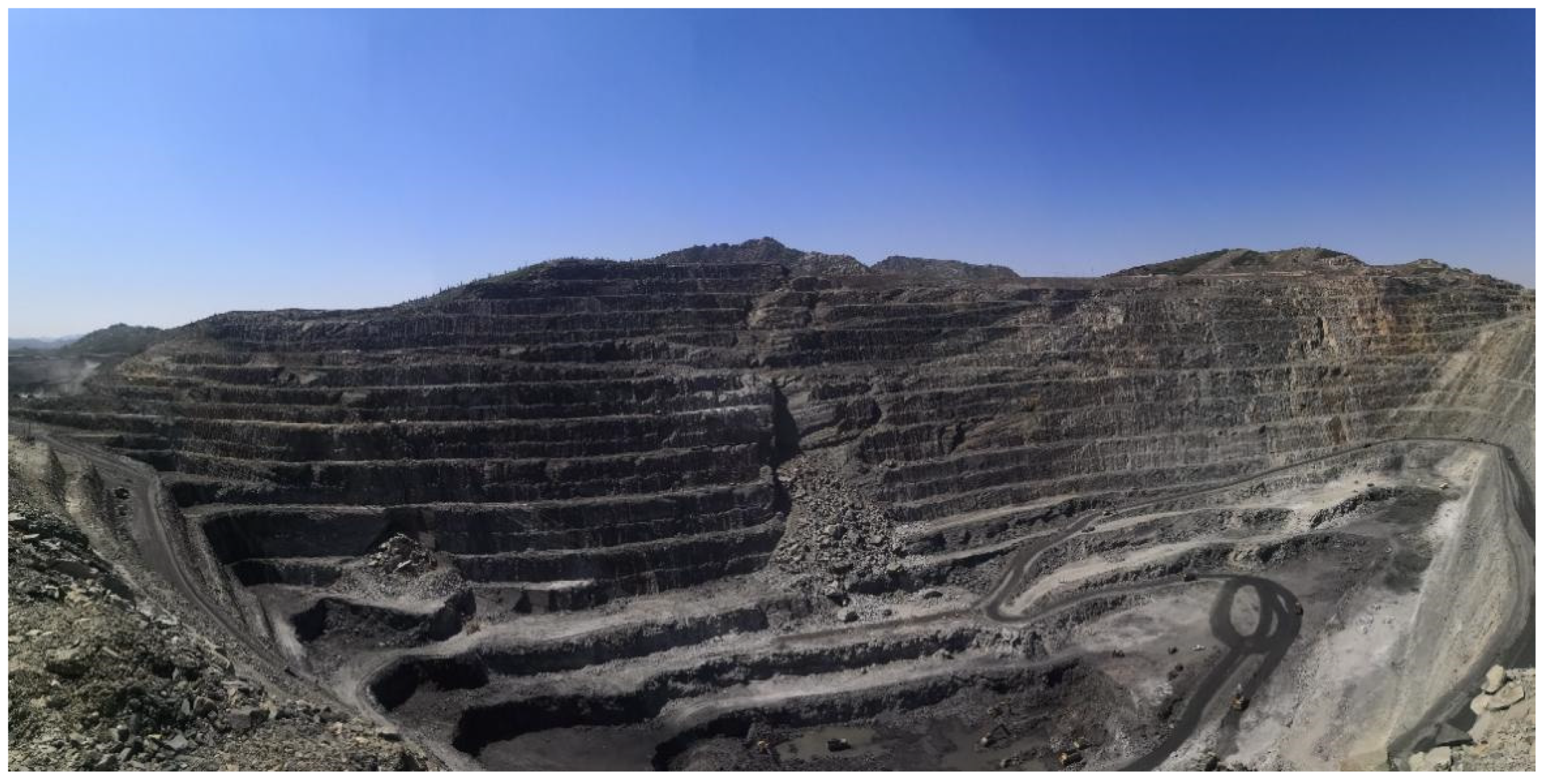
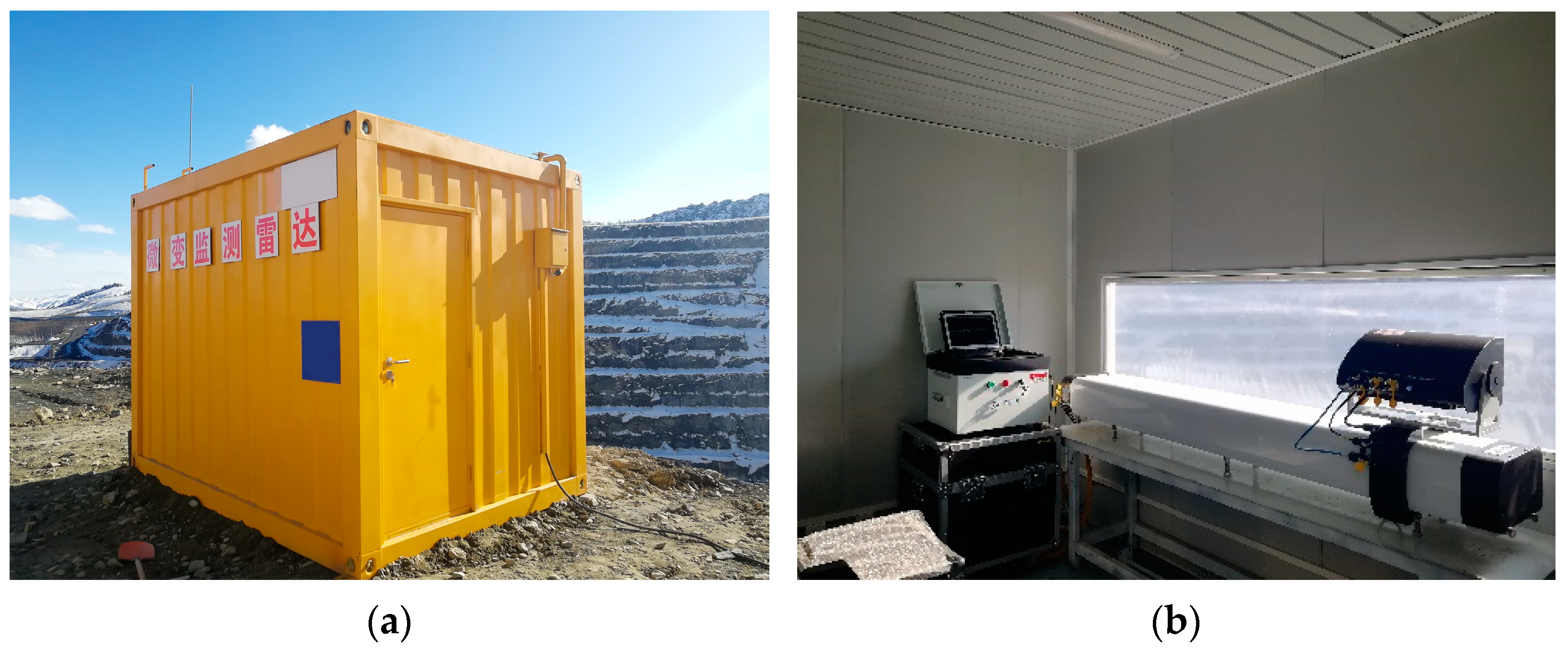
2. Study Area
3. Method
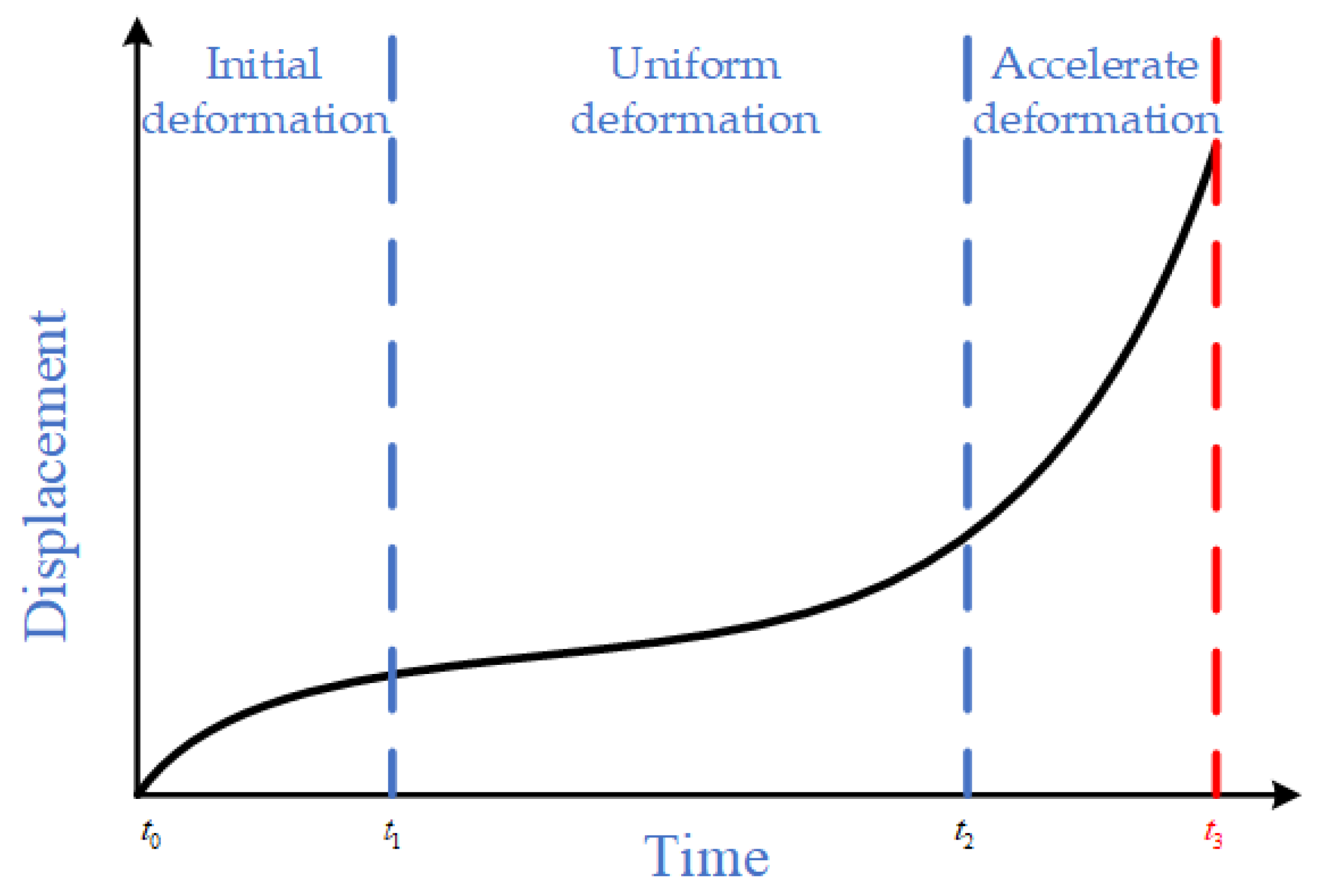
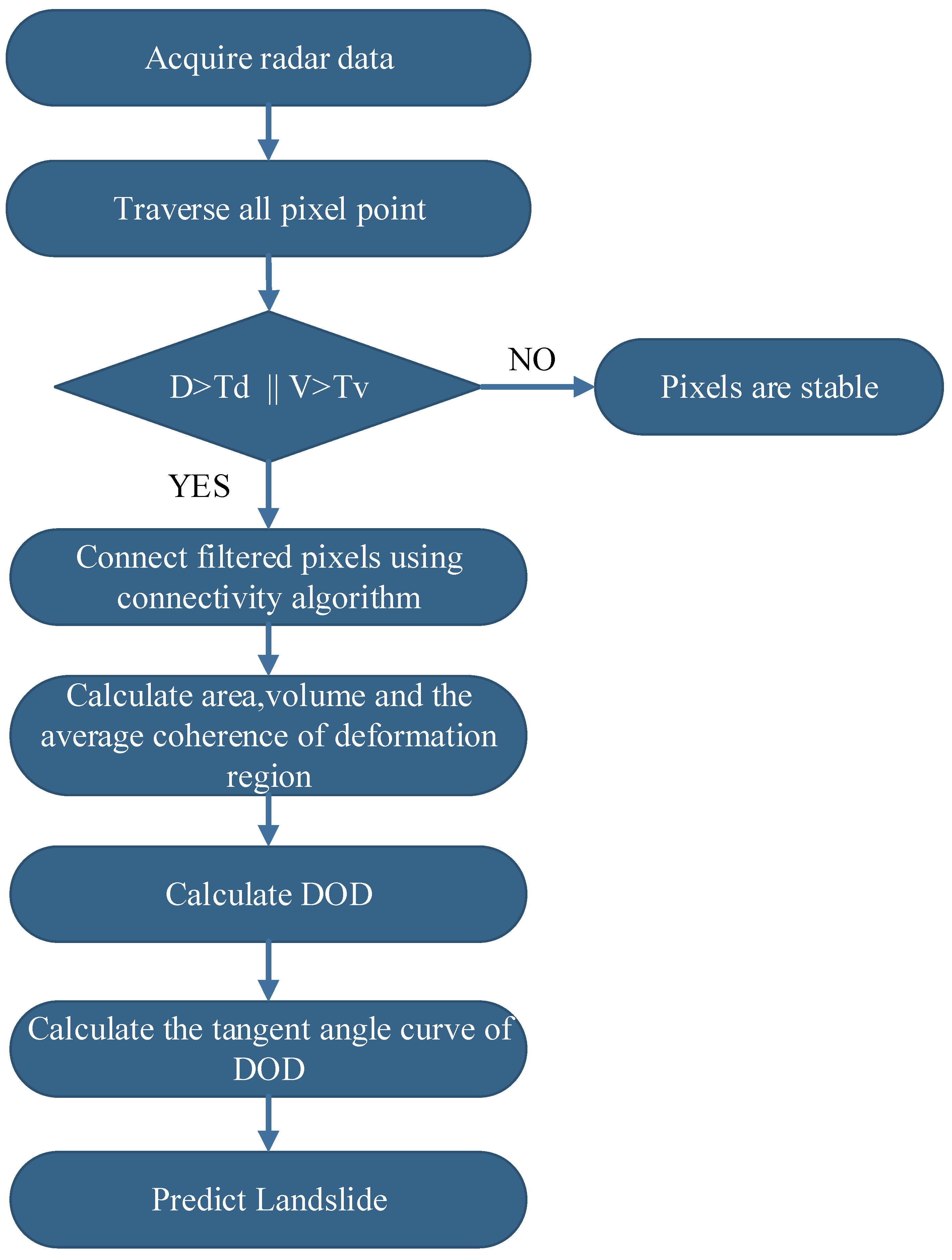
3.1. Forecast Process
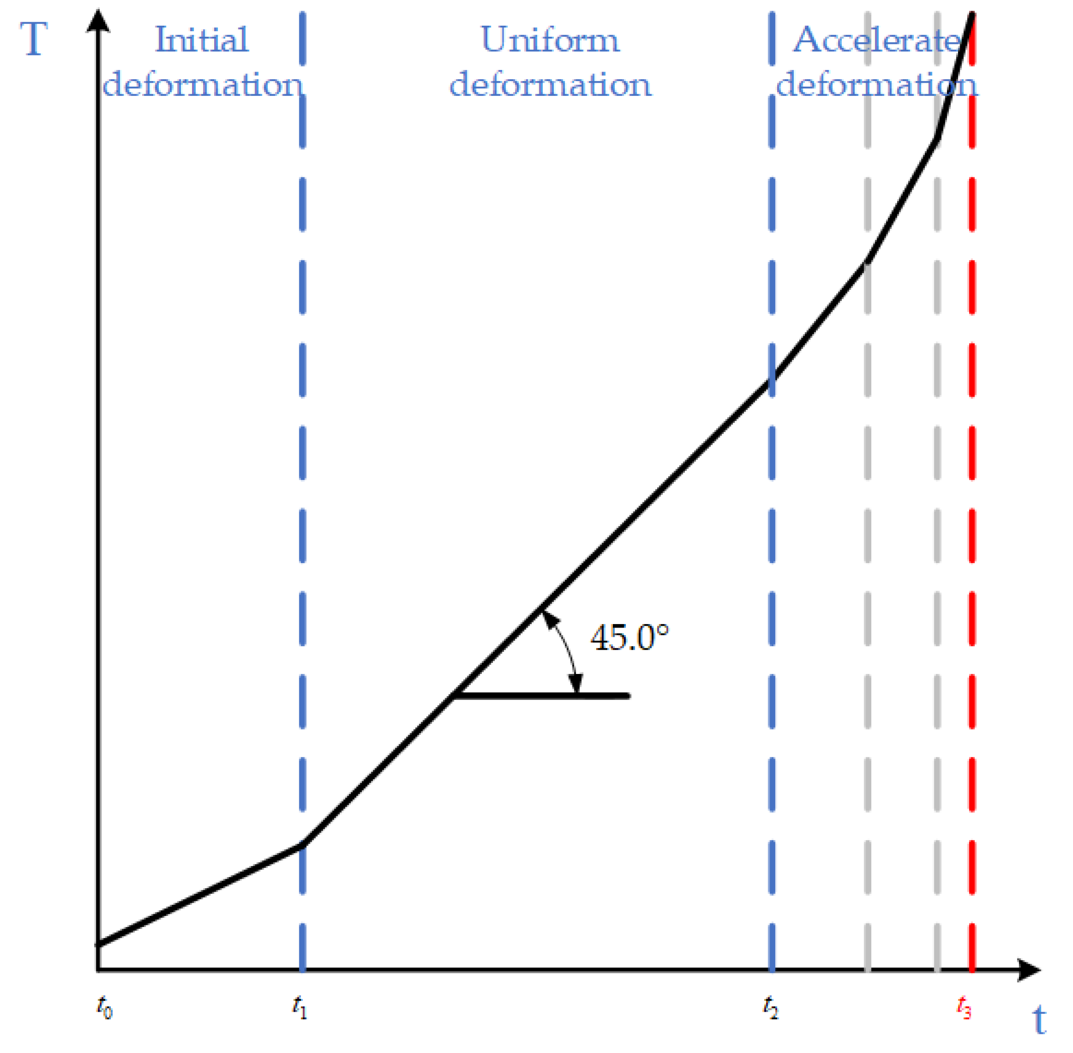
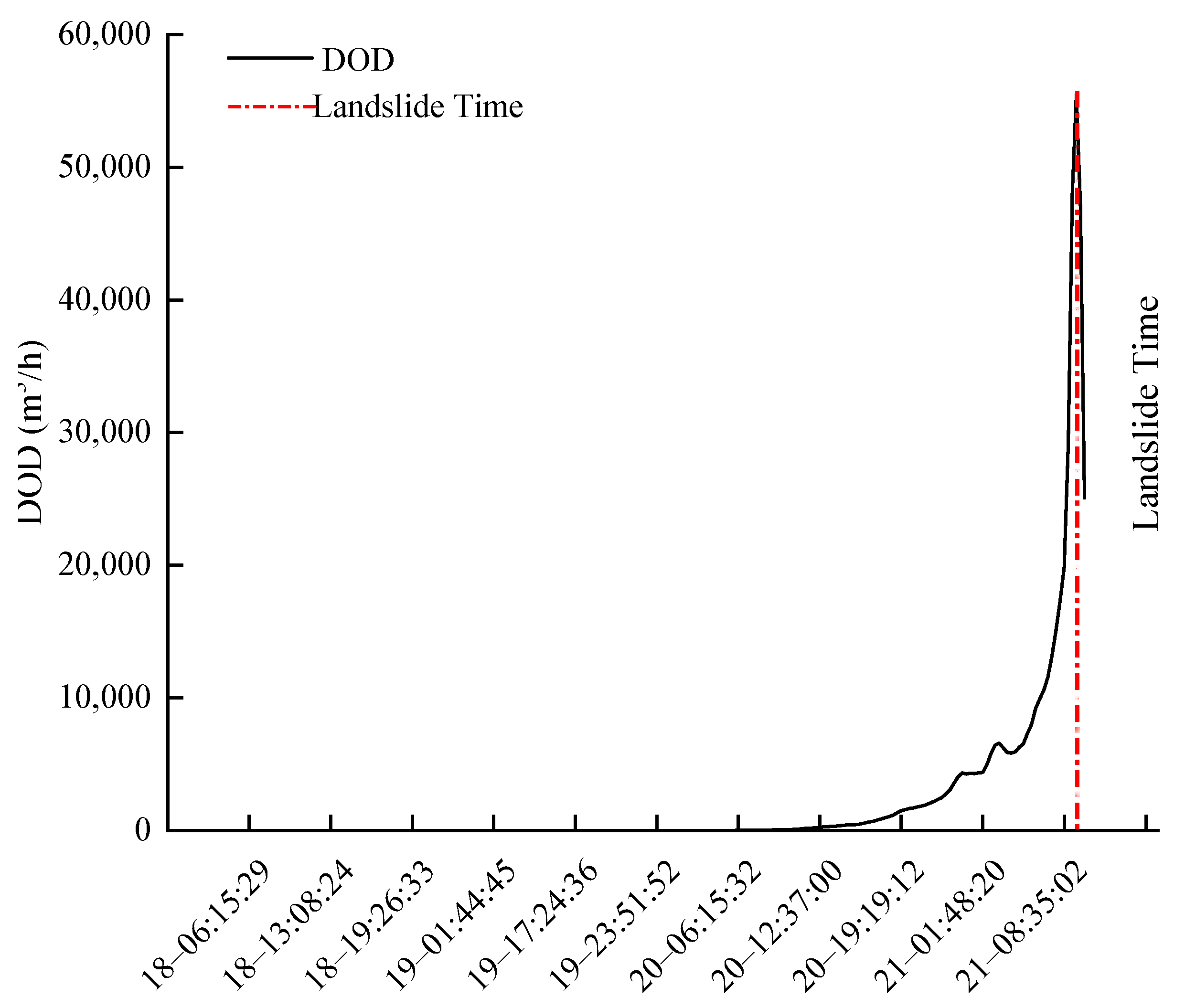
3.2. DOD
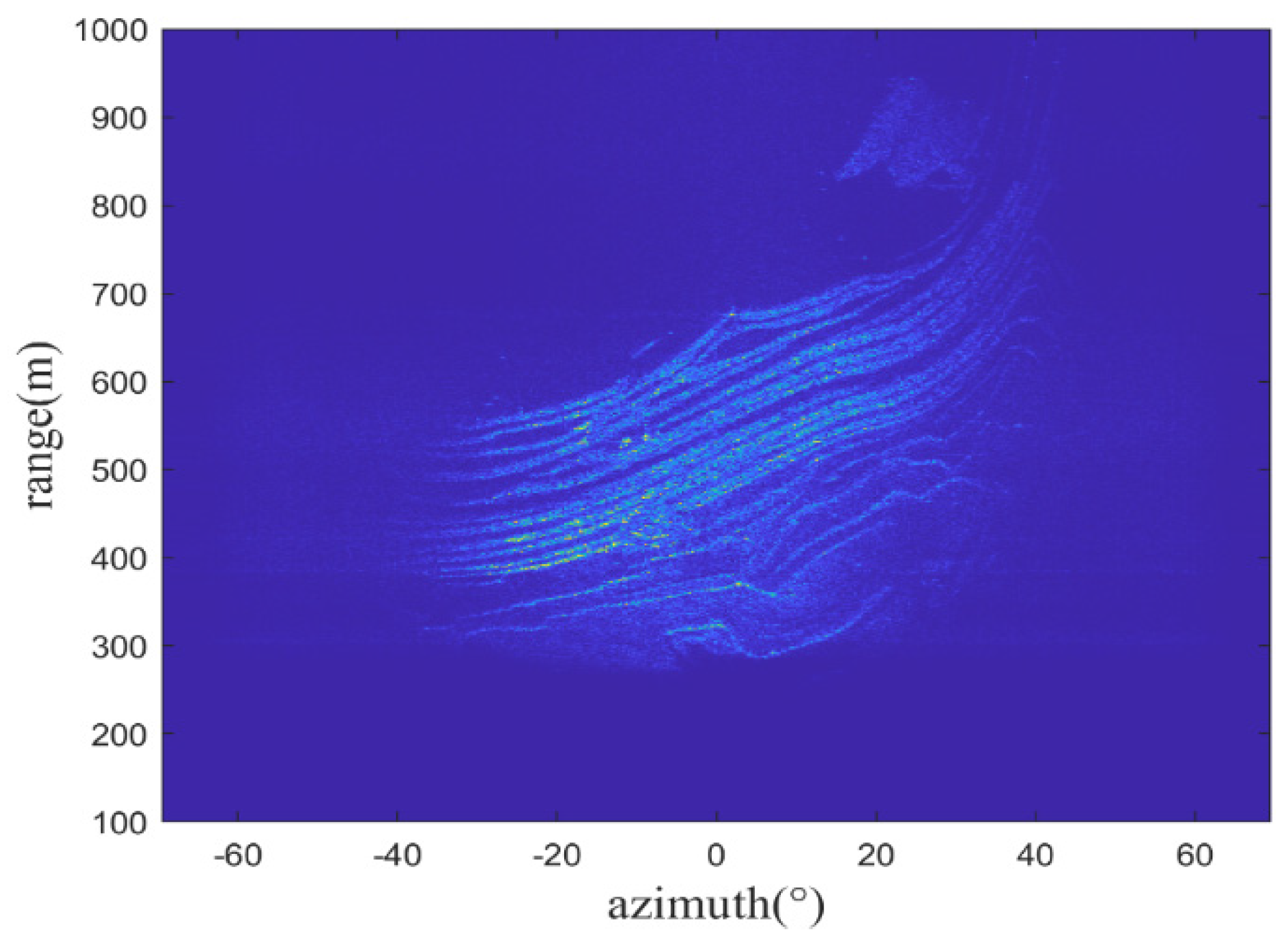
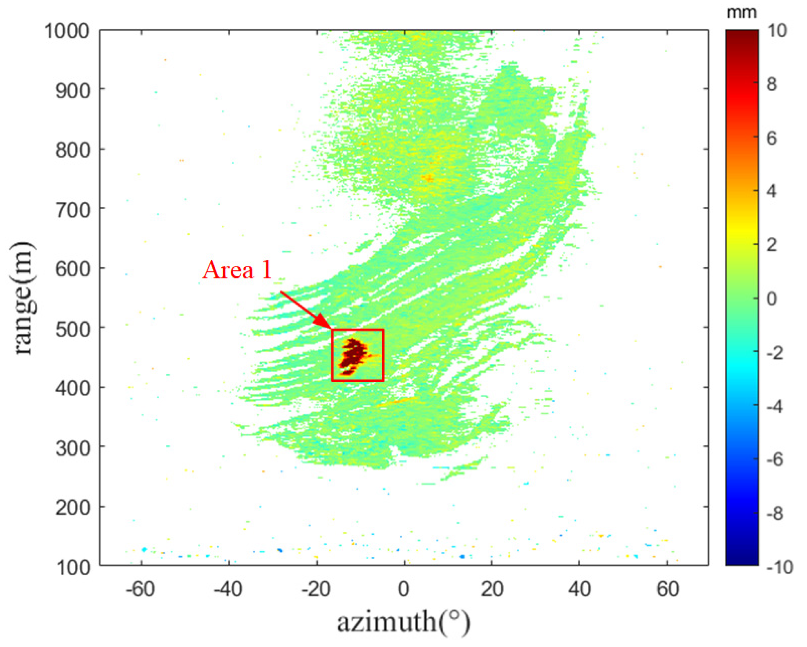
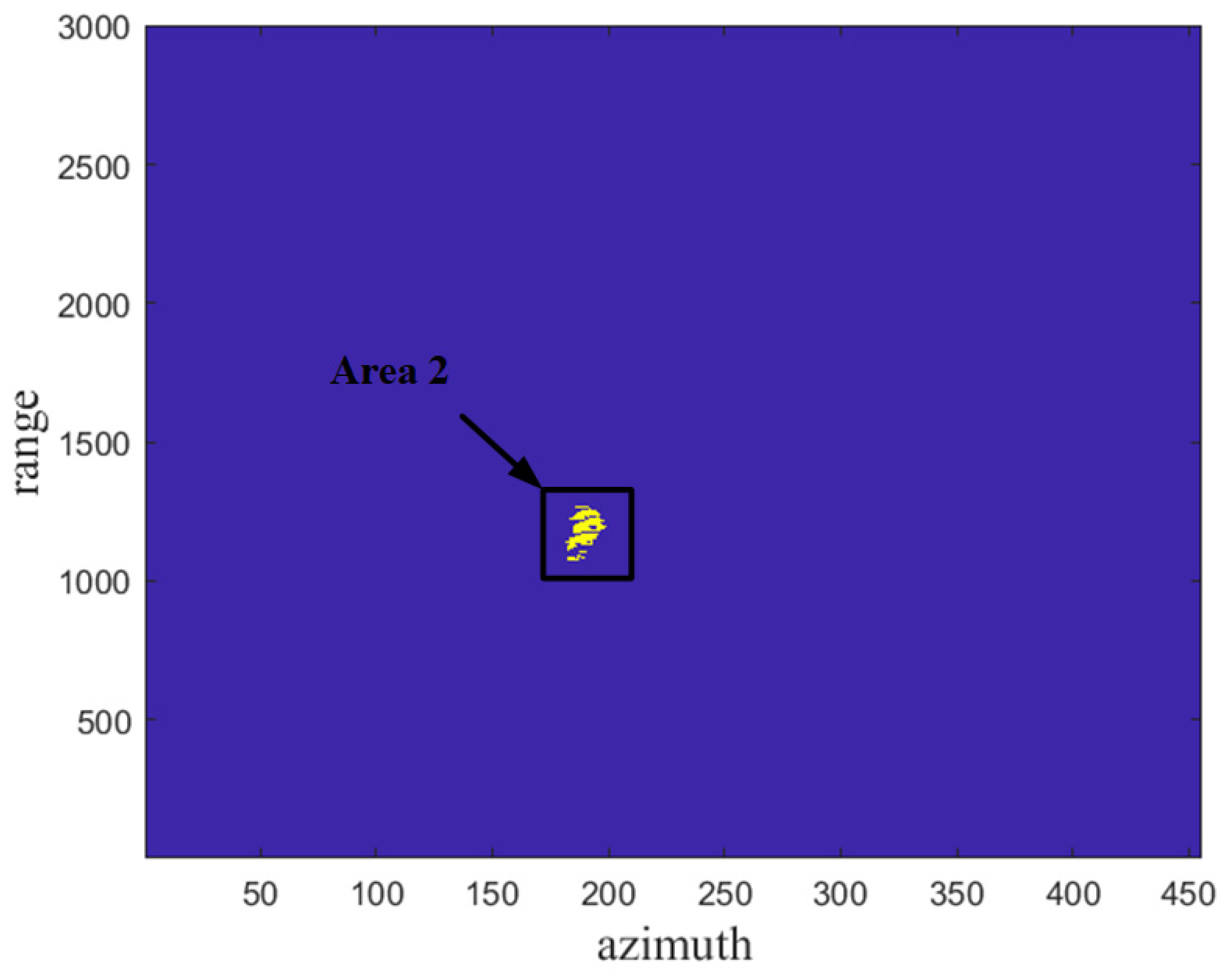
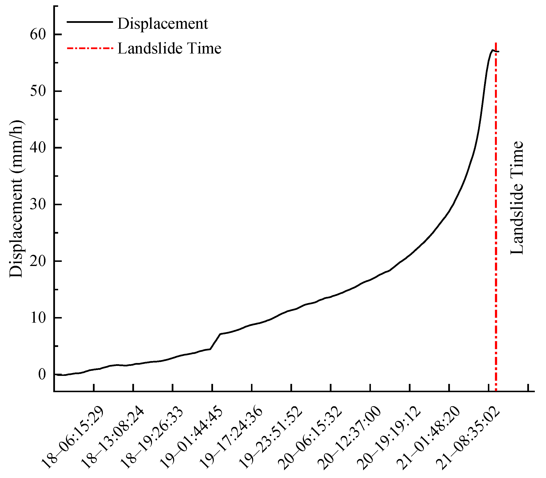
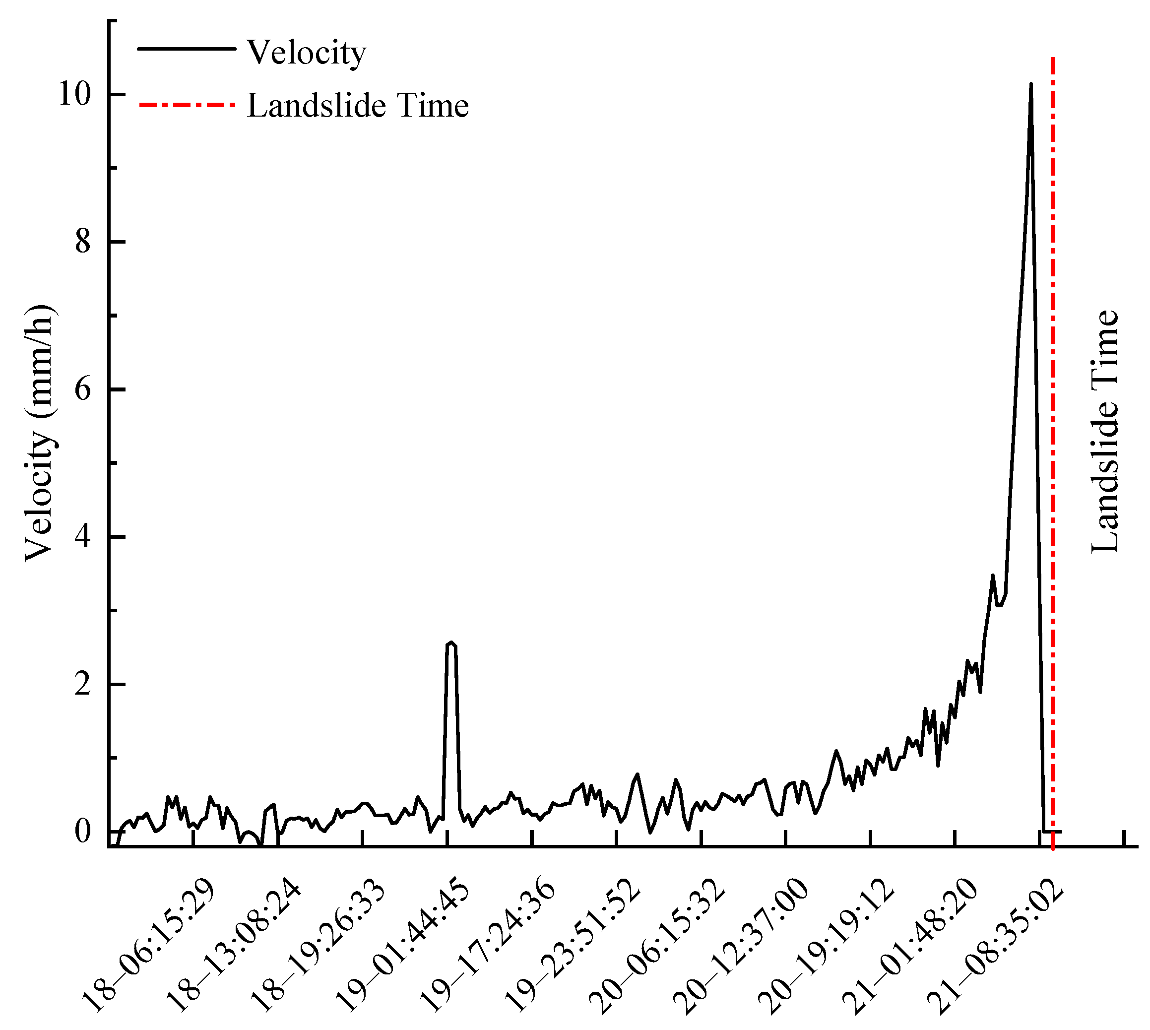
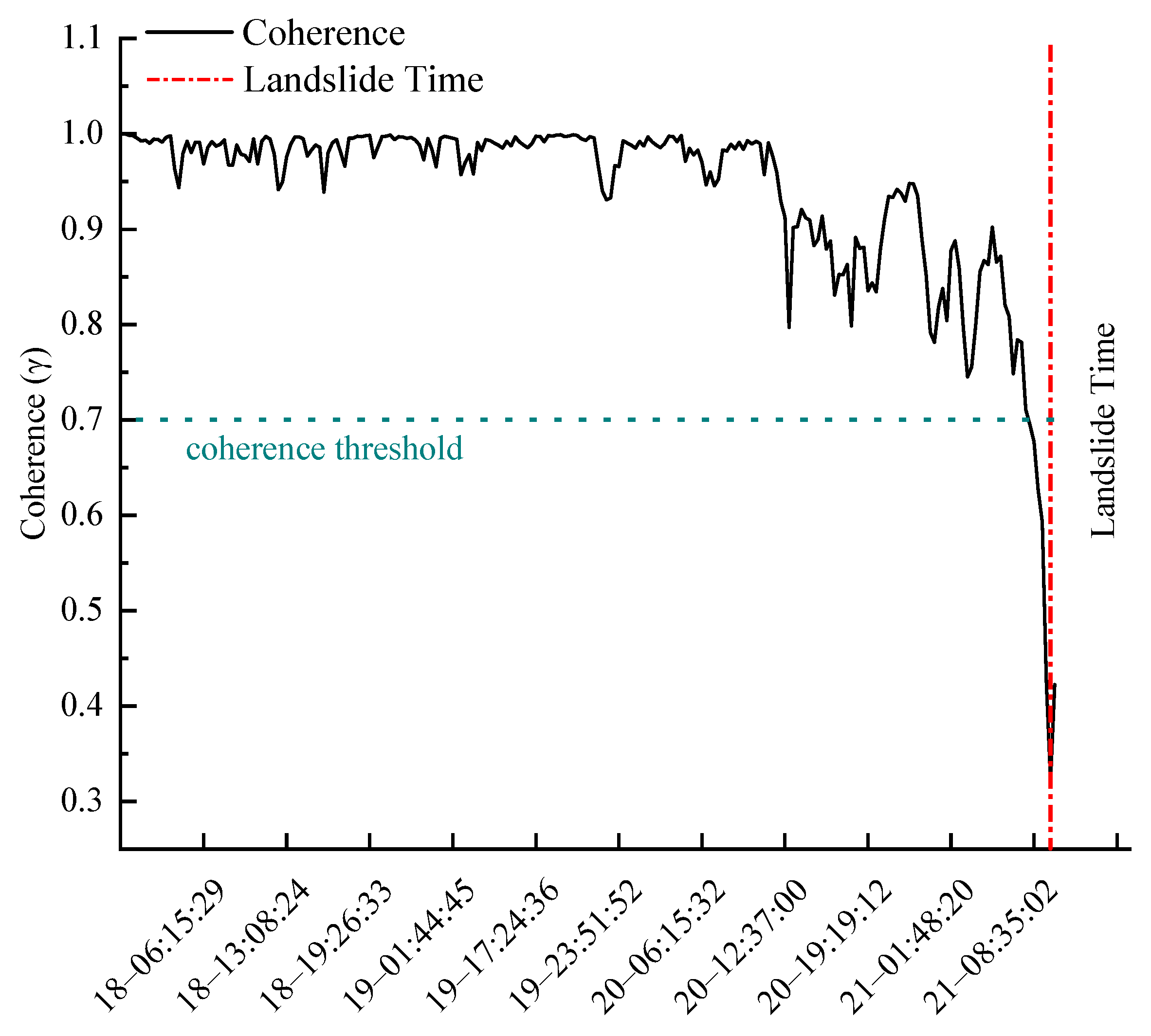
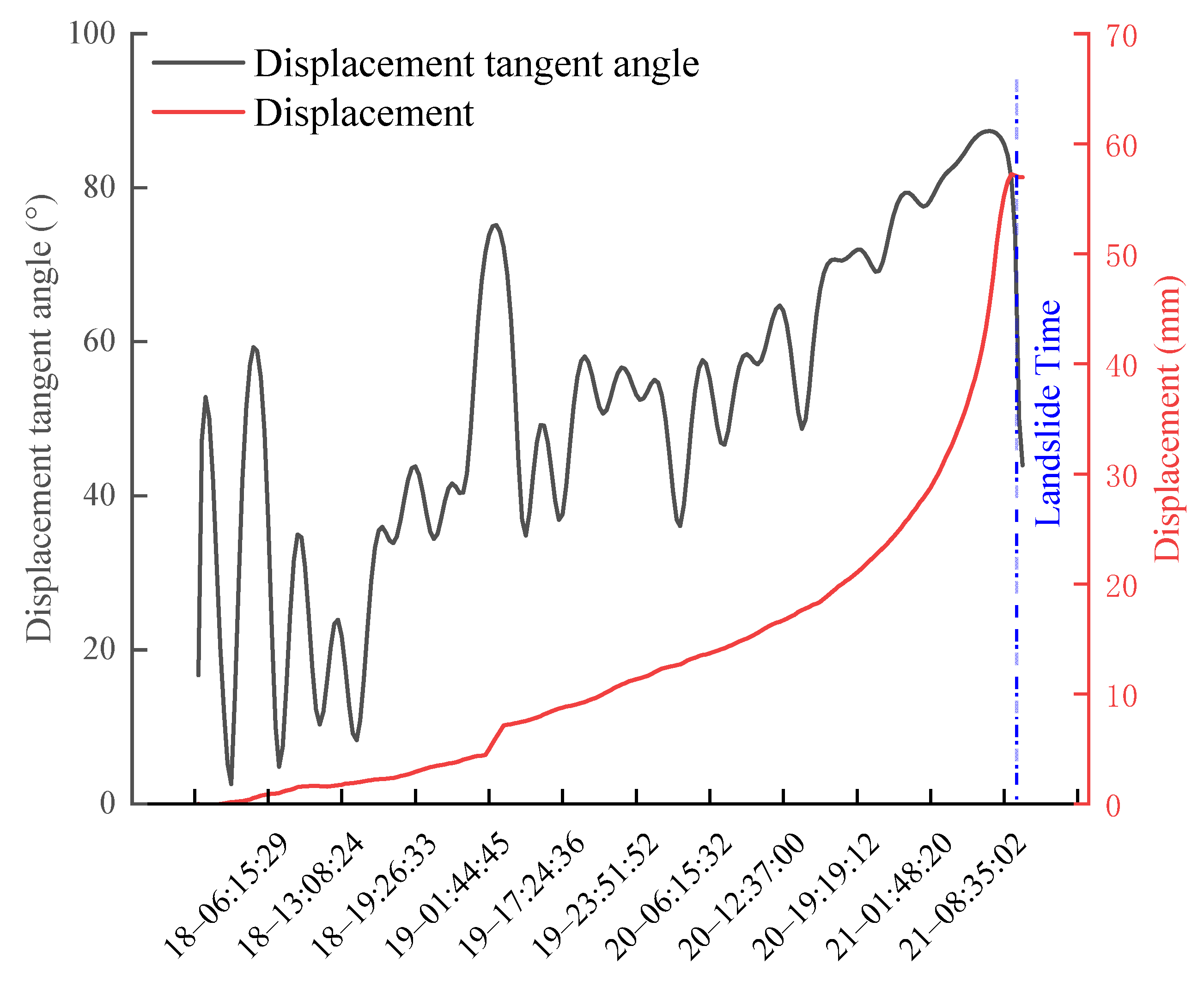
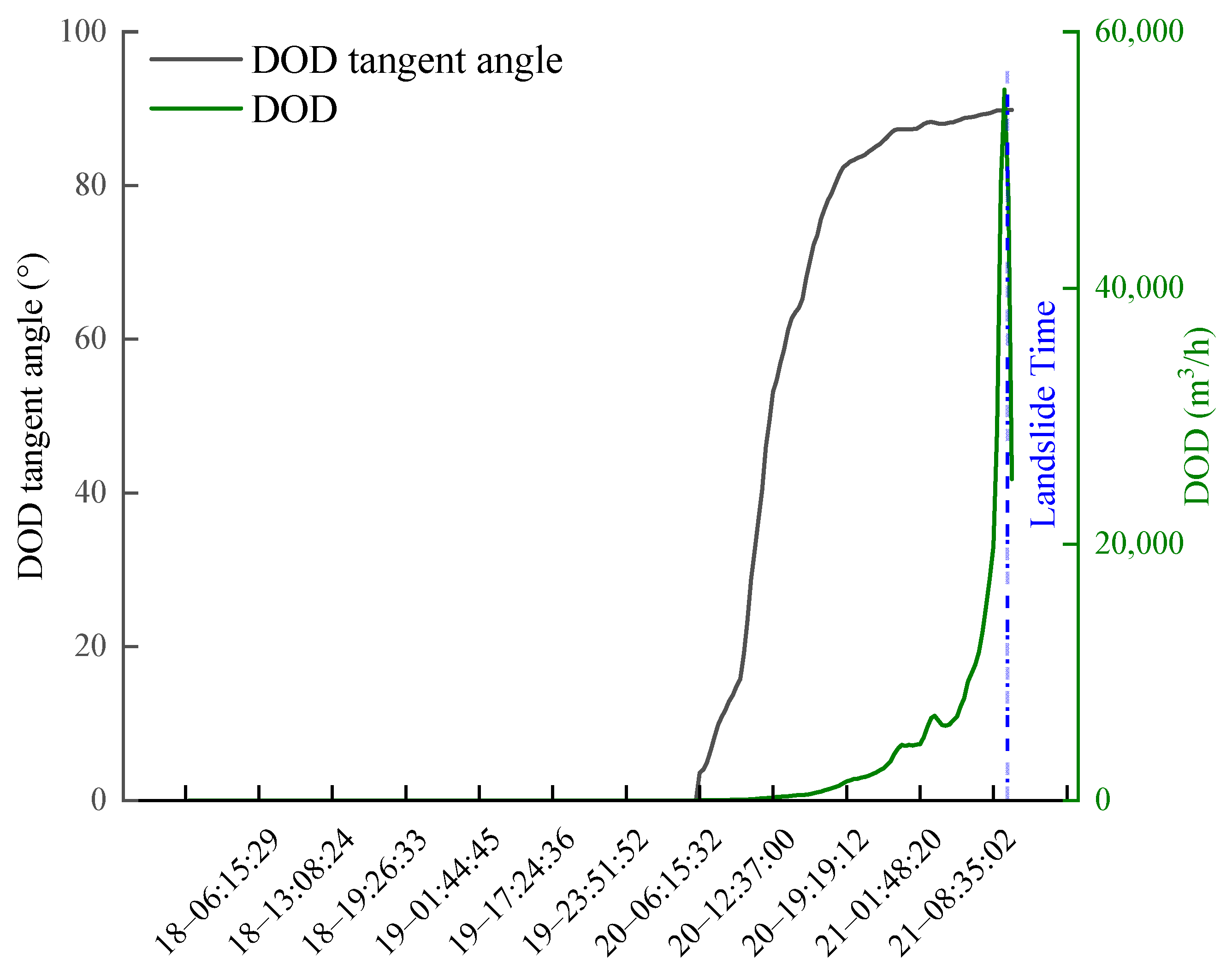
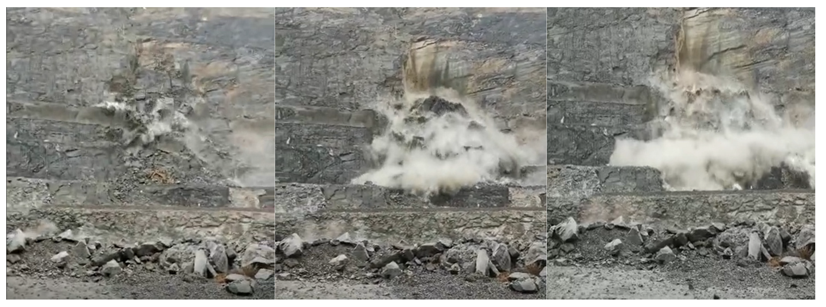
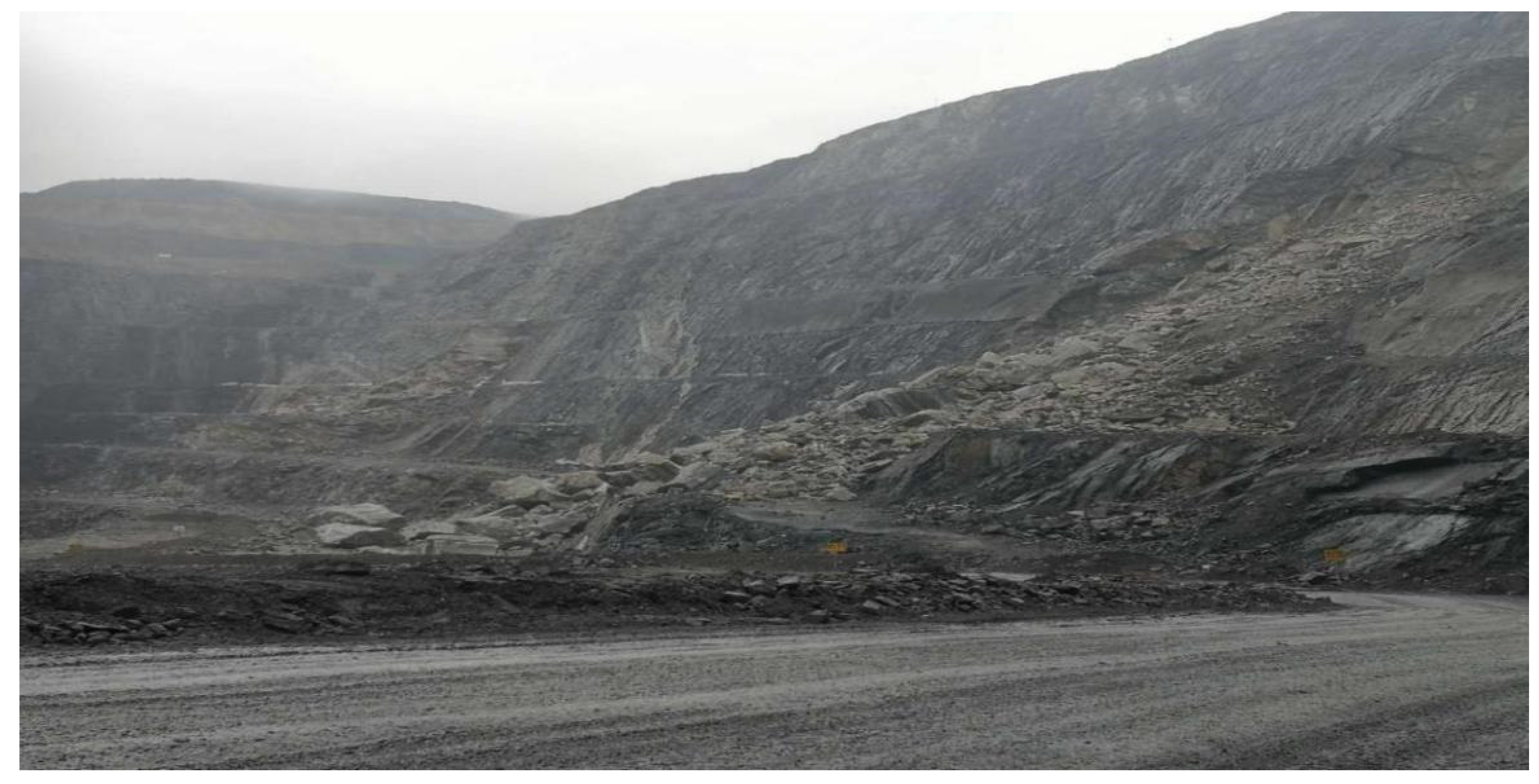
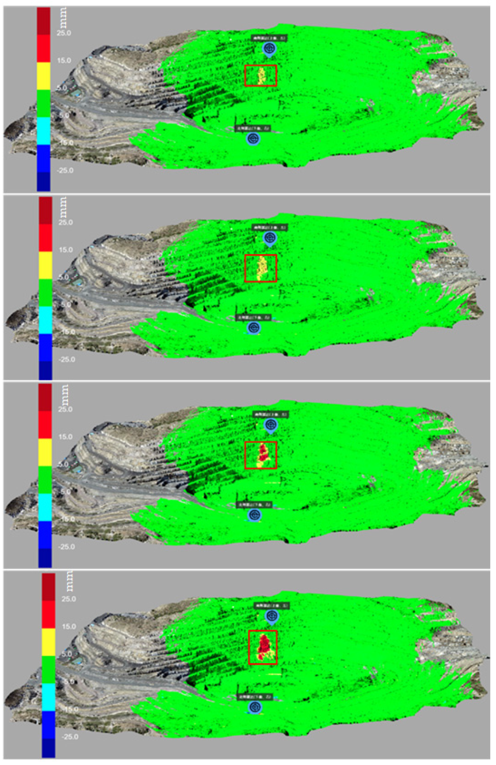
4. Result
5. Discussion
6. Conclusions
Author Contributions
Funding
Data Availability Statement
Acknowledgments
Conflicts of Interest
References
- Haque, U.; da Silva, P.F.; Devoli, G.; Pilz, J.; Zhao, B.; Khaloua, A.; Wilopo, W.; Andersen, P.; Lu, P.; Lee, J. The Human Cost of Global Warming: Deadly Landslides and Their Triggers (1995–2014). Sci. Total Environ. 2019, 682, 673–684. [Google Scholar] [CrossRef] [PubMed]
- Lin, Q.; Wang, Y. Spatial and Temporal Analysis of a Fatal Landslide Inventory in China from 1950 to 2016. Landslides 2018, 15, 2357–2372. [Google Scholar] [CrossRef]
- Ma, G.; Hu, X.; Yin, Y.; Luo, G.; Pan, Y. Failure Mechanisms and Development of Catastrophic Rockslides Triggered by Precipitation and Open-Pit Mining in Emei, Sichuan, China. Landslides 2018, 15, 1401–1414. [Google Scholar] [CrossRef]
- Thiebes, B.; Bell, R.; Glade, T.; Jäger, S.; Mayer, J.; Anderson, M.; Holcombe, L. Integration of a Limit-Equilibrium Model into a Landslide Early Warning System. Landslides 2014, 11, 859–875. [Google Scholar] [CrossRef]
- Whittle, D.; Brazil, M.; Grossman, P.A.; Rubinstein, J.H.; Thomas, D.A. Combined Optimisation of an Open-Pit Mine Outline and the Transition Depth to Underground Mining. Eur. J. Oper. Res. 2018, 268, 624–634. [Google Scholar] [CrossRef]
- Amini, M. Stability Analysis of the North-Eastern Slope of Daralou Copper Open Pit Mine against a Secondary Toppling Failure. Eng. Geol. 2019, 249, 89–101. [Google Scholar] [CrossRef]
- Obregon, C.; Mitri, H. Probabilistic Approach for Open Pit Bench Slope Stability Analysis—A Mine Case Study. Int. J. Min. Sci. Technol. 2019, 29, 629–640. [Google Scholar] [CrossRef]
- Song, D.; Che, A.; Zhu, R.; Ge, X. Dynamic Response Characteristics of a Rock Slope with Discontinuous Joints under the Combined Action of Earthquakes and Rapid Water Drawdown. Landslides 2018, 15, 1109–1125. [Google Scholar] [CrossRef]
- Wang, Y.; Zhang, N.N.; Sun, Z.; Fei, W. The major domestic natural disasters in 2017. Disaster Reduct. China 2018, 5, 38–41. [Google Scholar]
- Tian, H.; Bai, R.; Zhao, H. Achievement and developing trend of open-pit mining in China. Opencast Min. Technol. 2019, 34, 1–9. [Google Scholar]
- Yang, T.; Wang, H.; Dong, X. Current situation problems and countermeasures of intelligent evaluation of slope stability in open pit. J. China Coal Soc. 2020, 45, 2277–2295. [Google Scholar]
- Jiao, R.; Wang, S.; Yang, H.; Guo, X.; Han, J.; Pei, X.; Yan, C. Comprehensive Remote Sensing Technology for Monitoring Landslide Hazards and Disaster Chain in the Xishan Mining Area of Beijing. Remote Sens. 2022, 14, 4695. [Google Scholar] [CrossRef]
- Ge, D.; Dai, K.; Guo, Z.; Li, Z. Early Identification of Serious Geological Hazards with Integrated Remote Sensing Technologies: Thoughts and Recommendations. Geomat. Inf. Sci. Wuhan Univ. 2019, 44, 996–1007. [Google Scholar]
- Xu, Q.; Dong, X.J.; Li, W.L. Integrated space-air-ground early detection, monitoring and warning system for potential catastrophic geohazards. Geomat. Inf. Sci. Wuhan Univ. 2019, 44, 957–966. [Google Scholar]
- Li, Z.H.; Song, C.; Yu, C. Application of satellite radar remote sensing to landslide detection and monitoring: Challenges and solutions. Geomat. Inf. Sci. Wuhan Univ. 2019, 44, 967–979. [Google Scholar]
- Qin, H.; Ma, H.; Yu, Z. Analysis Method of Landslide Early Warning and Prediction Supported by Ground-Based SAR Technology. Geomat. Inf. Sci. Wuhan Univ. 2020, 45, 1697–1706. [Google Scholar]
- Bozzano, F.; Mazzanti, P.; Prestininzi, A.; Scarascia Mugnozza, G. Research and development of advanced technologies for landslide hazard analysis in Italy. Landslides 2010, 7, 381–385. [Google Scholar] [CrossRef]
- Intrieri, E.; Gigli, G.; Casagli, N.; Nadim, F. Brief communication “landslide early warning system: Toolbox vand general concepts”. Nat. Hazards Earth Syst. Sci. 2013, 13, 85–90. [Google Scholar] [CrossRef]
- Tommaso, C.; Paolo, F.; Emanuele, I.; Kostas, B.; Nicola, C. On the monitoring and early-warning of brittle slope failures in hard rock masses: Examples from an open-pit mine. Eng. Geol. 2017, 228, 71–81. [Google Scholar]
- Lopez-Vinielles, J.; Ezquerro, P.; Fernandez-Merodo, J. Remote analysis of an open-pit slope failure: Las Cruces case study, Spain. Landslides 2020, 17, 2173–2188. [Google Scholar] [CrossRef]
- Carlà, T.; Intrieri, E.; Raspini, F.; Bardi, F.; Farina, P.; Ferretti, A.; Colombo, D.; Novali, F.; Casagli, N. Perspectives on the prediction of catastrophic slope failures from satellite InSAR. Sci. Rep. 2019, 9, 14137. [Google Scholar] [CrossRef]
- Crosetto, M.; Monserrat, O.; Luzi, G.; Cuevas-González, M.; Devanthéry, N. A noninterferometric procedure for deformation mea-surement using GB-SAR imagery. IEEE Geosci. Remote Sens. Lett. 2013, 11, 34–38. [Google Scholar] [CrossRef]
- Dick, G.J.; Eberhardt, E.; Cabrejo-Liévano, A.G.; Stead, D.; Rose, N.D. Development of an early-warning time-of-failure analysis methodology for open-pit mine slopes utilizing ground-based slope stability radar monitoring data. Can. Geotech. J. 2015, 52, 515–529. [Google Scholar] [CrossRef]
- Zeng, T.; Deng, Y.K. Development state and application examples of ground-based differential interferometric radar. J. Radars 2019, 8, 154–170. [Google Scholar]
- Liu, B.; He, K.; Han, M.; Hu, X.; Ma, G.; Wu, M. Application of UAV and GB-SAR in Mechanism Research and Monitoring of Zhonghaicun Landslide in Southwest China. Remote Sens. 2021, 13, 1653. [Google Scholar] [CrossRef]
- Owerko, T.; Kuras, P.; Ortyl, Ł. Atmospheric Correction Thresholds for Ground-Based Radar Interferometry Deformation Monitoring Estimated Using Time Series Analyses. Remote Sens. 2020, 12, 2236. [Google Scholar] [CrossRef]
- Hu, C.; Deng, Y.; Tian, W.; Zhao, Z. A Compensation Method for a Time–Space Variant Atmospheric Phase Applied to Time-Series GB-SAR Images. Remote Sens. 2019, 11, 2350. [Google Scholar] [CrossRef]
- Huang, Z.; Sun, J.; Tan, W.; Huang, P.; Han, K. Investigation of Wavenumber Domain Imaging Algorithm for Ground-Based Arc Array SAR. Sensors 2017, 17, 2950. [Google Scholar] [CrossRef]
- Gao, H.; Liao, M.; Liu, X.; Xu, W.; Fang, N. Source Geometry and Causes of the 2019 Ms6.0 Changning Earthquake in Sichuan, China Based on InSAR. Remote Sens. 2022, 14, 2082. [Google Scholar] [CrossRef]
- Qi, L.; Tan, W.; Huang, P.; Xu, W.; Qi, Y.; Zhang, M. Landslide Prediction Method Based on a Ground-Based Micro-Deformation Monitoring Radar. Remote Sens. 2020, 12, 1230. [Google Scholar] [CrossRef]
- Xiao, T.; Huang, W.; Deng, Y.; Tian, W.; Sha, Y. Long-Term and Emergency Monitoring of Zhongbao Landslide Using Space-Borne and Ground-Based InSAR. Remote Sens. 2021, 13, 1578. [Google Scholar] [CrossRef]
- Zhang, H.; Wang, C. Research on DInSAR Method Based on Coherent Target; Science Press: Beijing, China, 2009; pp. 12–28. [Google Scholar]
- Zheng, X.; Yang, X.; Ma, H.; Ren, G.; Zhang, K.; Yang, F.; Li, C. Integrated Ground-Based SAR Interferometry, Terrestrial Laser Scanner, and Corner Reflflector Deformation Experiments. Sensors 2018, 18, 4401. [Google Scholar] [CrossRef] [PubMed]
- Fukuzono, T. A method to predict the time of slope failure caused by rainfall using the inverse number of velocity of surface displacement. J. Japan Landslide Soci. 1985, 2, 8–13. [Google Scholar] [CrossRef]
- Voight, B. A method for prediction of volcanic eruptions. Nature 1988, 332, 125–130. [Google Scholar] [CrossRef]
- Zhou, X.; Ye, T. Inverse-Square-Root-Acceleration Method for Predicting the Failure Time of Landslides. Sci. China Technol. Sci. 2021, 64, 1127–1136. [Google Scholar] [CrossRef]
- Du, J.; Yin, K.; Lacasse, S. Displacement prediction in colluvial landslides, three Gorges reservoir, China. Landslides 2013, 10, 203–218. [Google Scholar] [CrossRef]
- Du, W.; Wang, G. A one-step Newmark displacement model for probabilistic seismic slope displacement hazard analysis. Eng. Geol. 2016, 205, 12–23. [Google Scholar] [CrossRef]
- Lian, C.; Zeng, Z.; Yao, W.; Tang, H. Multiple neural networks switched prediction for landslide displacement. Eng. Geol. 2015, 186, 91–99. [Google Scholar] [CrossRef]
- Chousianitis, K.; Gaudio, V.; Kalogeras, I. Predictive model of Arias intensity and Newmark displacement for regional scale evaluation of earthquake-induced landslide hazard in Greece. Soil Dyn. Earthq. Eng. 2014, 65, 11–29. [Google Scholar] [CrossRef]
- Xu, Q.; Zeng, Y.; Qian, J.; Wang, C.; He, C. Study on an improved tangential angle and the corresponding landslide pre-warning criteria. Geol. Bull. China 2009, 28, 501–505. [Google Scholar]
- Xu, Q.; Peng, D.; He, C.; Qi, X.; Zhao, K.; Xiu, D. Theory and method of monitoring and early warning for sudden loess landslide—A case study atheifangtai terrace. J. Eng. Geol. 2020, 28, 111–121. [Google Scholar]
- Xu, Q. Understanding the landslide monitoring and early warning:consideration to practical issues. J. Eng. Geol. 2020, 28, 360–374. [Google Scholar]
- Intrieri, E.; Gigli, G.; Mugnai, F.; Fanti, R.; Casagli, N. Design and implementation of a landslide early warning system. Eng. Geol. 2012, 147, 124–136. [Google Scholar] [CrossRef]
- Wang, J.; Zhang, Z. System Engineering Geology Study on Typical Rapid Loess Landslides; Sichuan Science & Technology Press: Chengdu, China, 1999. [Google Scholar]
- Touzi, R.; Lopes, A. Coherence estimation for SAR imagery. IEEE Trans. Geosci. Remote Sens. 1999, 37, 135–149. [Google Scholar] [CrossRef]
- Zebker, H.A.; Villasenor, J. Decorrelation in interferometric radar echoes. IEEE Trans. Geosci. Remote Sens. 1992, 30, 950–959. [Google Scholar] [CrossRef]


| Deformation Stage | Initial Acceleration | Medium Acceleration | Critical Sliding |
|---|---|---|---|
| Deformation velocity, V (mm/h) | V > 0.5 | 2 < V < 0.5 | V > 3 |
| Cumulative displacement, D (mm/day) | D > 15 | 14 < D < 30 | D > 30 |
| DOD tangent angle, α | 70° < α < 85° | 85° ≤ α < 89° | α ≥ 89° |
| Warning level | Warning | Caution | Alarm |
Disclaimer/Publisher’s Note: The statements, opinions and data contained in all publications are solely those of the individual author(s) and contributor(s) and not of MDPI and/or the editor(s). MDPI and/or the editor(s) disclaim responsibility for any injury to people or property resulting from any ideas, methods, instructions or products referred to in the content. |
© 2023 by the authors. Licensee MDPI, Basel, Switzerland. This article is an open access article distributed under the terms and conditions of the Creative Commons Attribution (CC BY) license (https://creativecommons.org/licenses/by/4.0/).
Share and Cite
Tan, W.; Wang, Y.; Huang, P.; Qi, Y.; Xu, W.; Li, C.; Chen, Y. A Method for Predicting Landslides Based on Micro-Deformation Monitoring Radar Data. Remote Sens. 2023, 15, 826. https://doi.org/10.3390/rs15030826
Tan W, Wang Y, Huang P, Qi Y, Xu W, Li C, Chen Y. A Method for Predicting Landslides Based on Micro-Deformation Monitoring Radar Data. Remote Sensing. 2023; 15(3):826. https://doi.org/10.3390/rs15030826
Chicago/Turabian StyleTan, Weixian, Yadong Wang, Pingping Huang, Yaolong Qi, Wei Xu, Chunming Li, and Yuejuan Chen. 2023. "A Method for Predicting Landslides Based on Micro-Deformation Monitoring Radar Data" Remote Sensing 15, no. 3: 826. https://doi.org/10.3390/rs15030826
APA StyleTan, W., Wang, Y., Huang, P., Qi, Y., Xu, W., Li, C., & Chen, Y. (2023). A Method for Predicting Landslides Based on Micro-Deformation Monitoring Radar Data. Remote Sensing, 15(3), 826. https://doi.org/10.3390/rs15030826