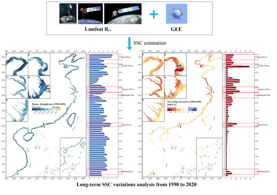
Mapping Suspended Sediment Changes in the Western Pacific Coasts
Abstract
:1. Introduction
2. Materials and Methods
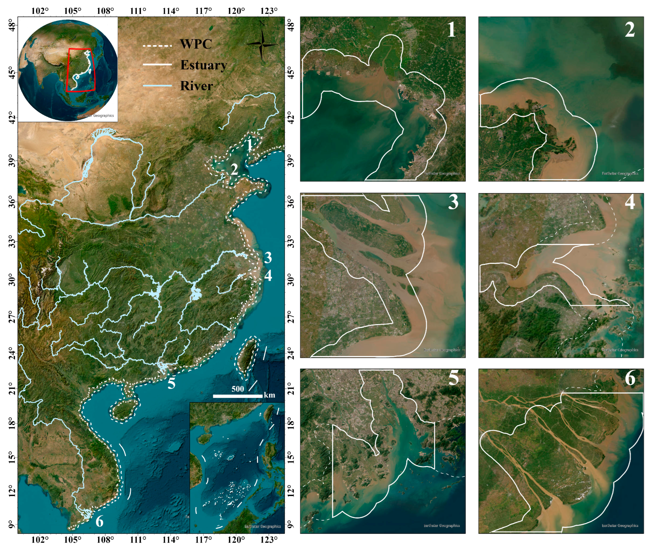
2.1. Study Area
2.2. Data and Processing
2.2.1. Satellite Data and Processing
2.2.2. In Situ Data Collection and Processing
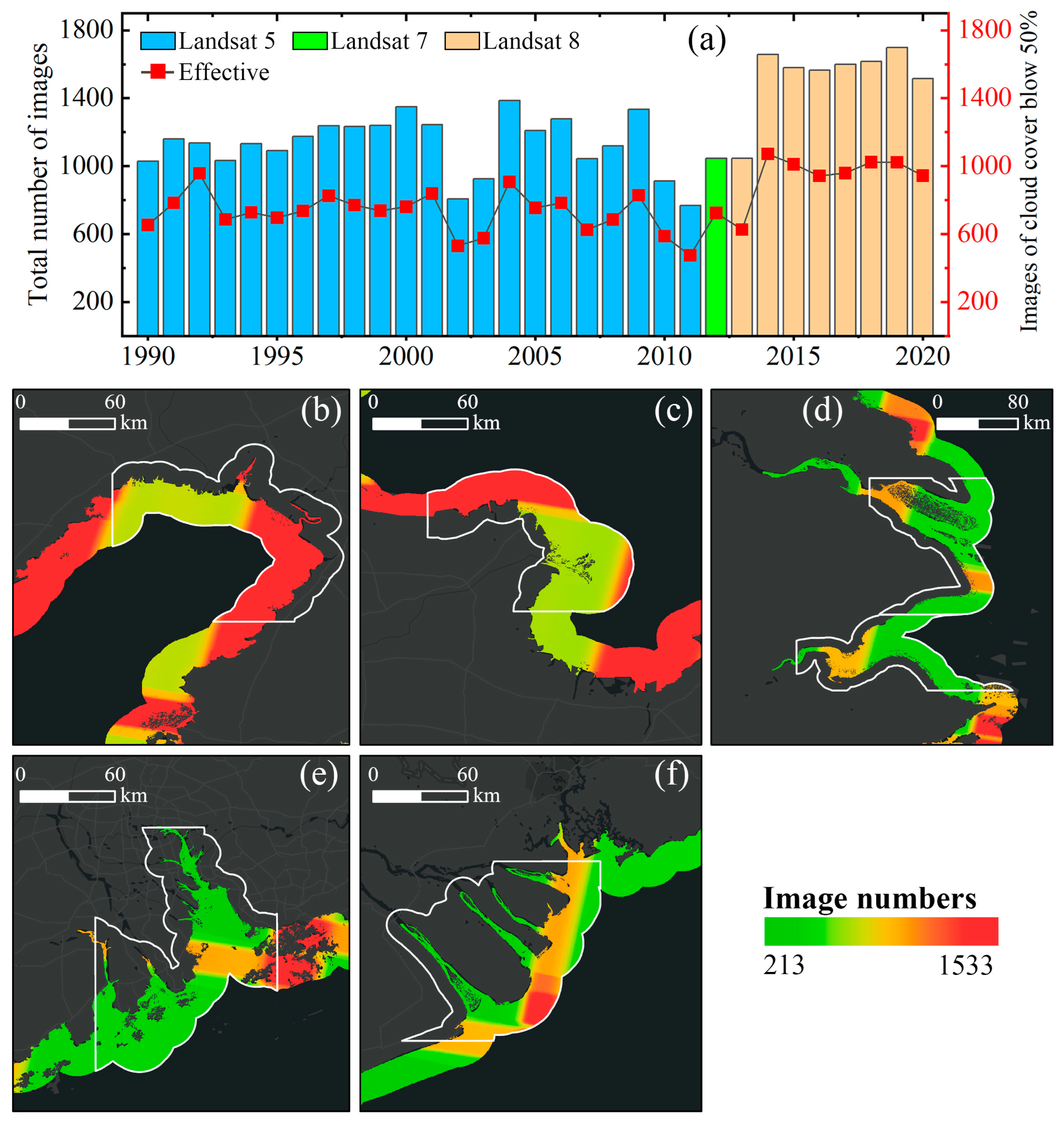
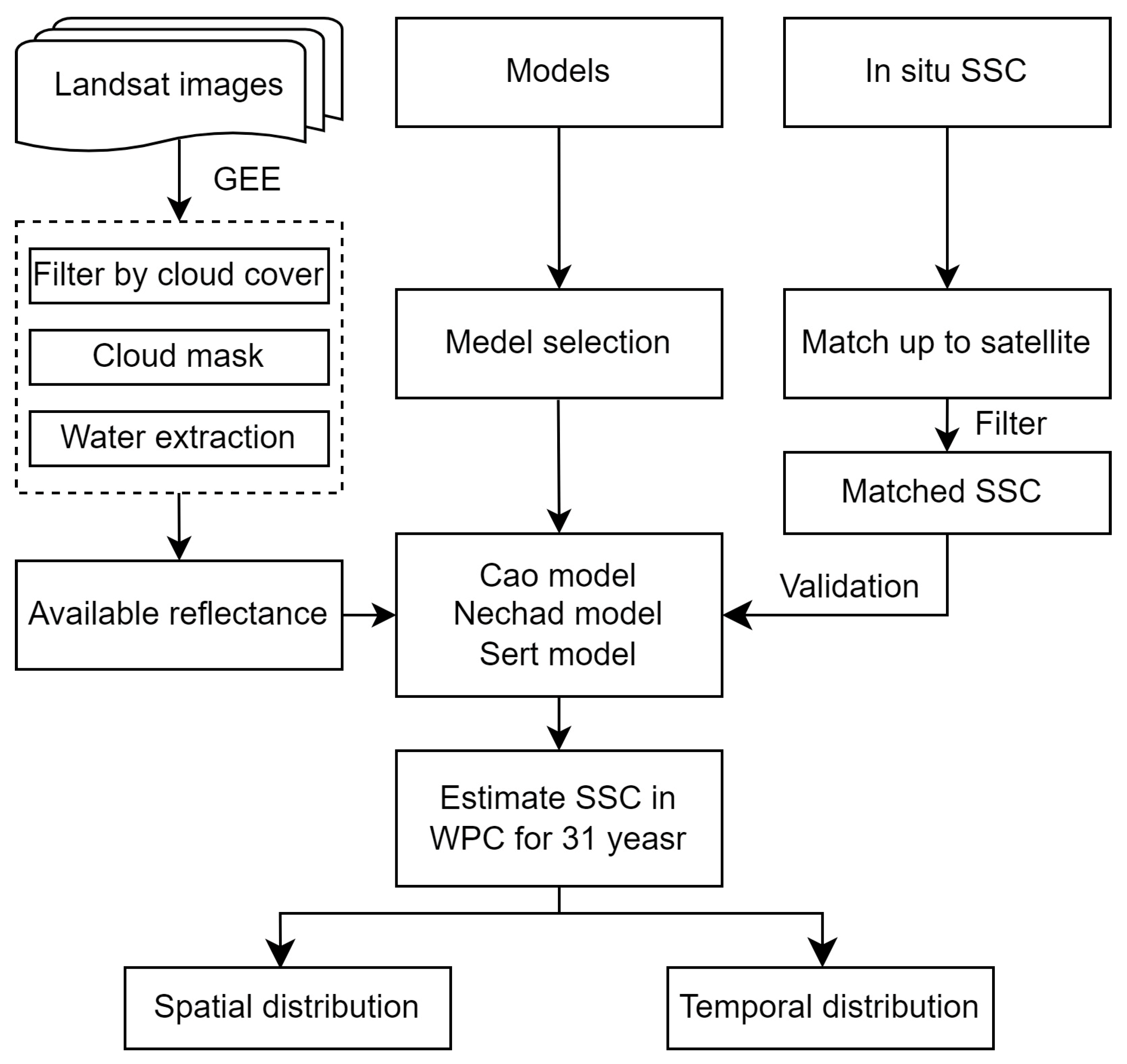
2.3. SSC Retrieval Models
2.4. Model Evaluation Metrics
2.5. SSC Temporal Variation and Trend Analysis
3. Results
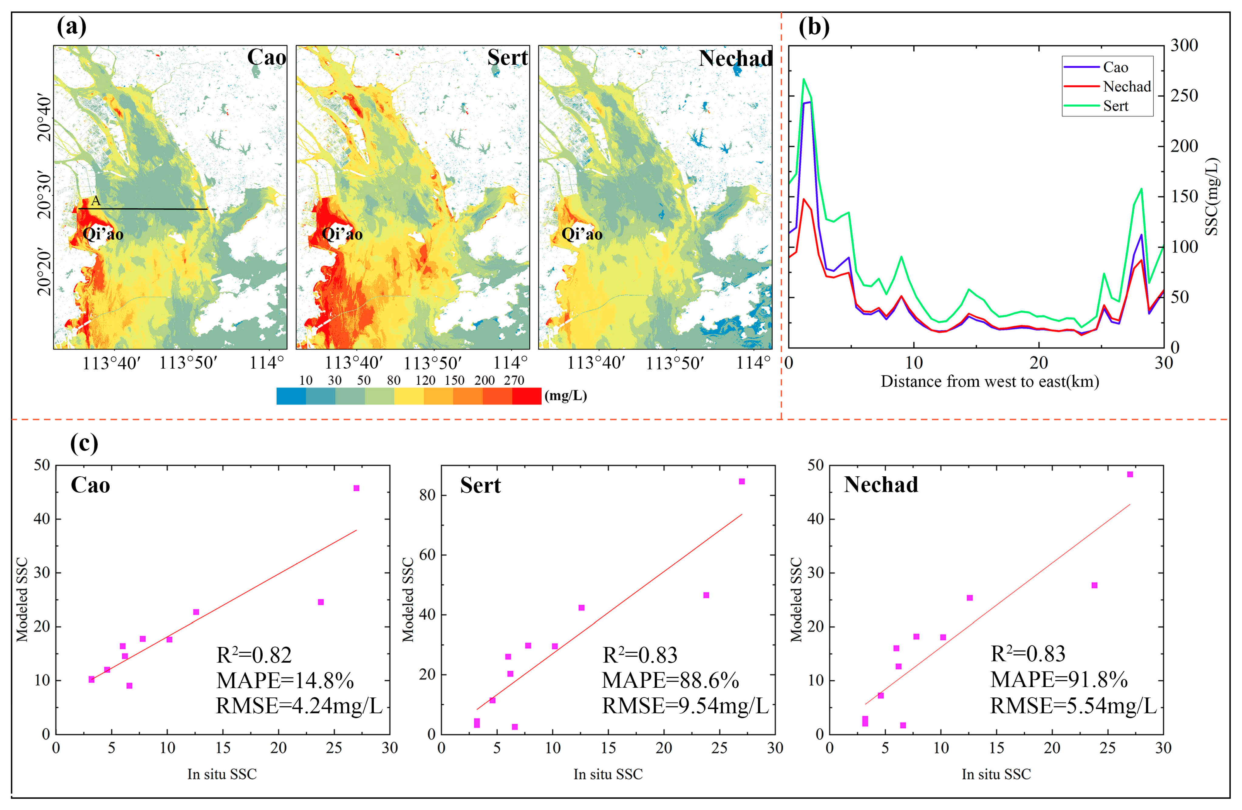
3.1. Model Performance Assessment
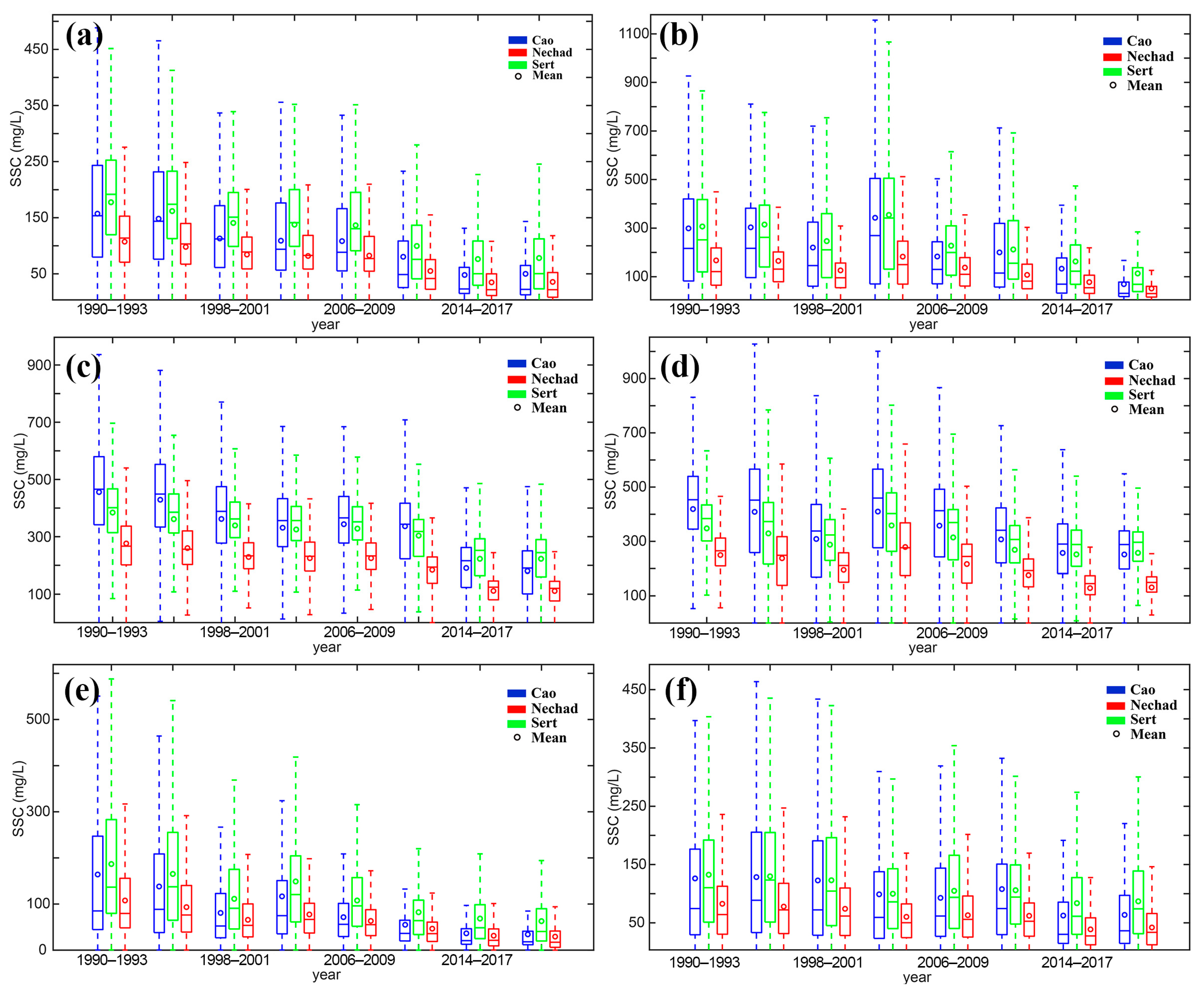
3.2. Interannual Changes in SSC across the Major Estuaries
3.3. Seasonal Variations in SSC
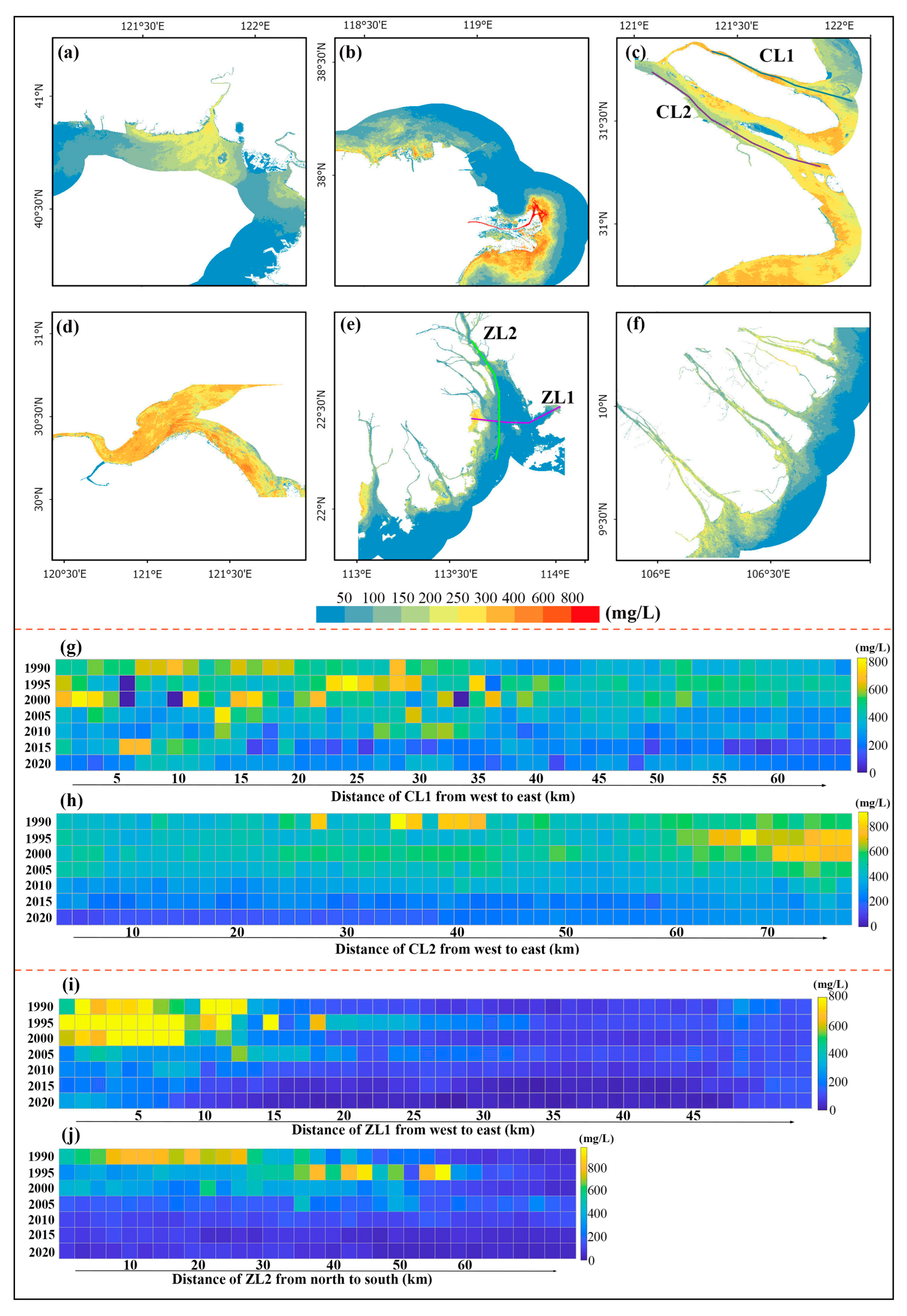
3.4. Spatial Patterns of SSC across Estuaries

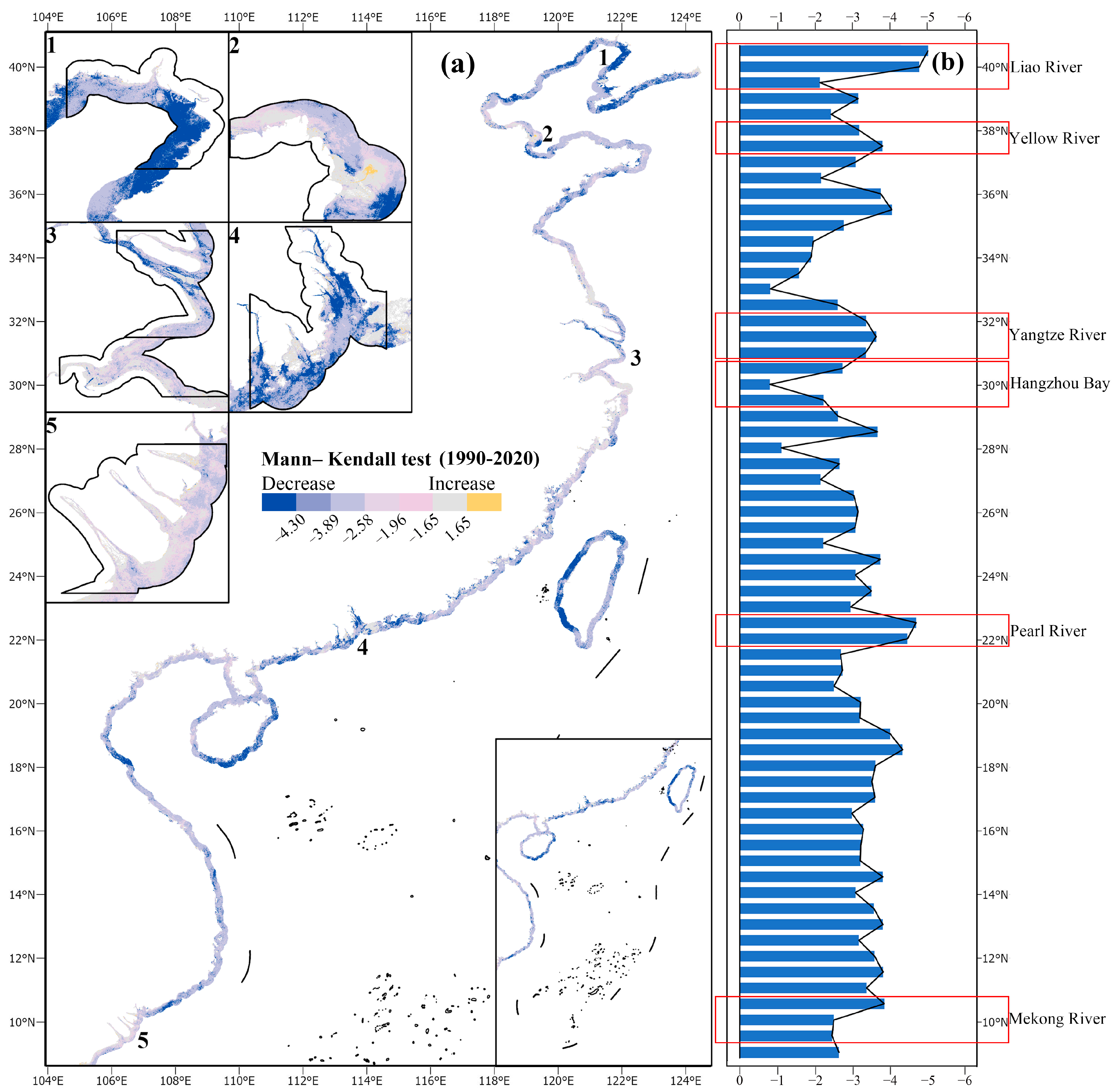
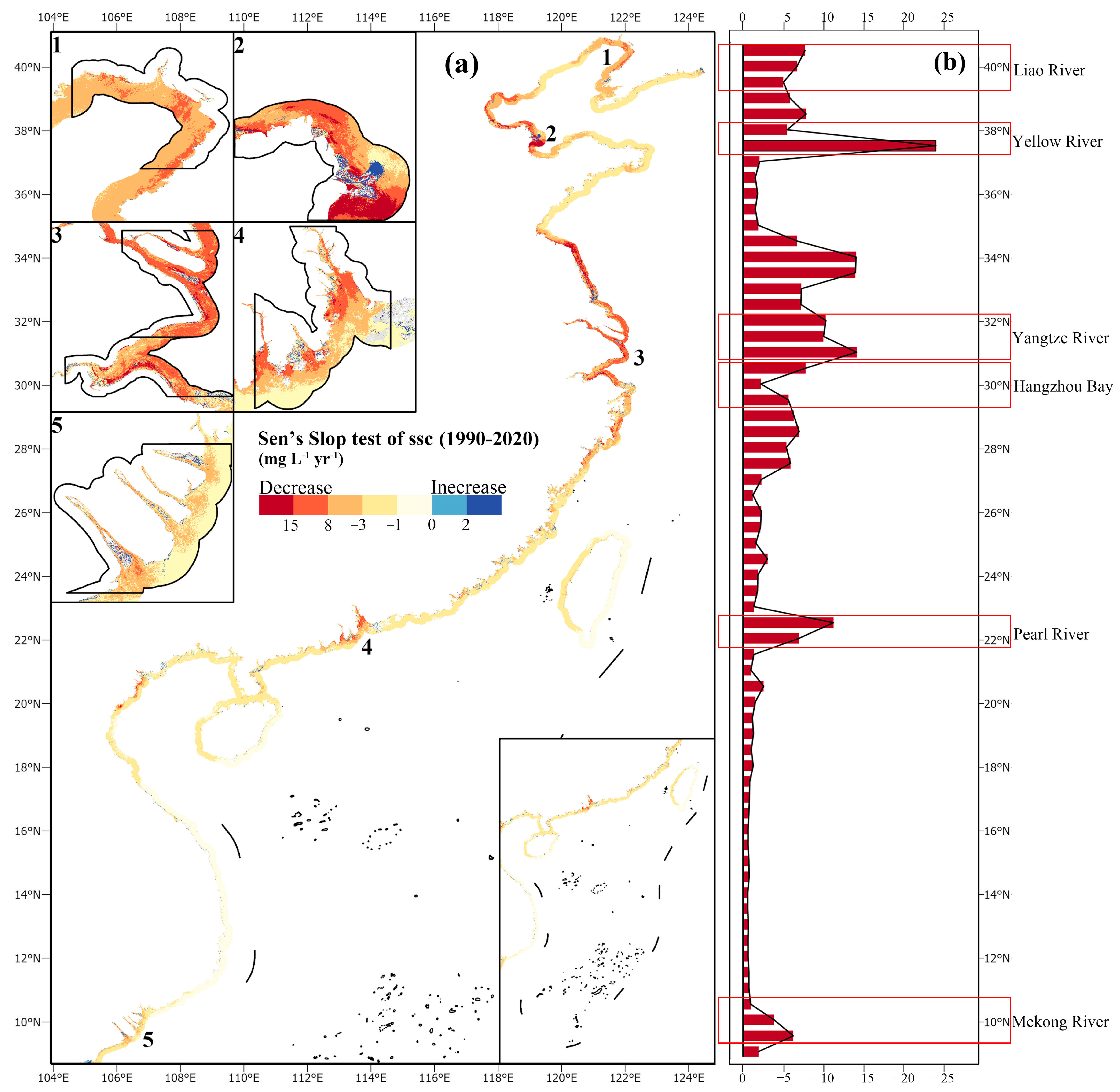
3.5. Long-Term SSC Variations along the WPC
4. Discussion
4.1. Possible Causes of Seasonal SSC Changes
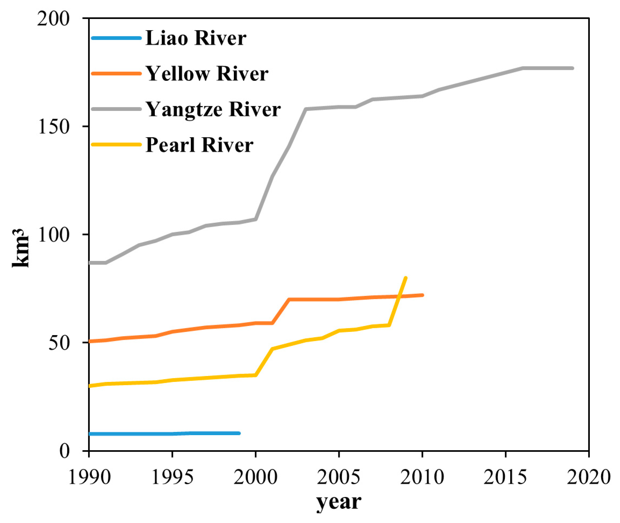
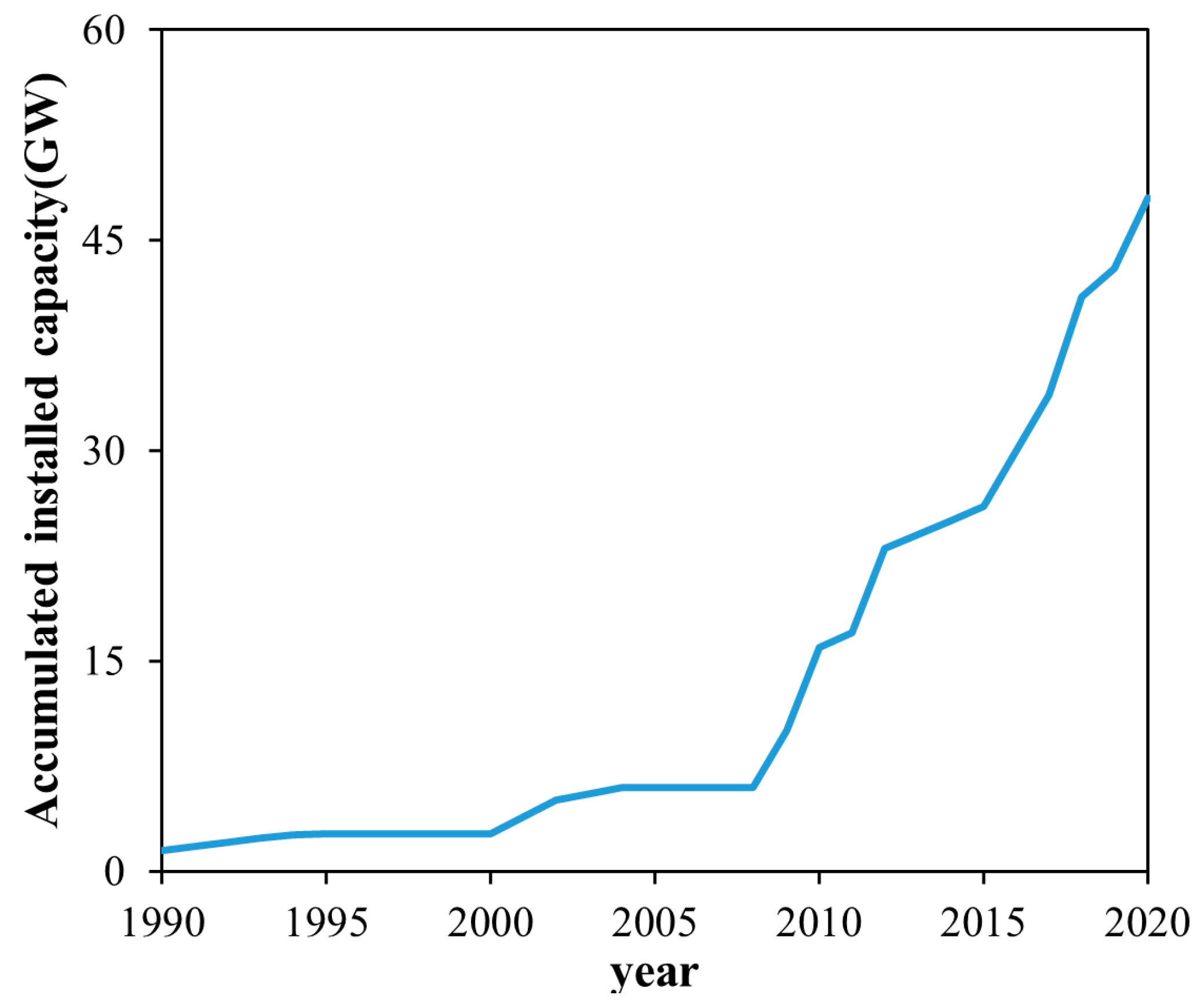
4.2. Possible Causes of Interannual SSC Changes
4.3. The Impact of Suspended Sediment Reduction
4.4. Sources of Study Uncertainty and Comparative Analysis
5. Conclusions
- (1)
- Estuarine decline in SSC: A compelling and noteworthy decline in SSC was observed across all six estuaries along the WPC. Among these, the Yangtze Estuary experienced the most pronounced reduction, while the Mekong River Estuary exhibited a relatively modest decline.
- (2)
- Distinct seasonal variations: Each of the six estuaries exhibited unique seasonal variations in SSC, primarily influenced by geographical factors specific to their respective locations.
- (3)
- Spatial gradient pattern: While most estuaries showed a consistent trend of decreasing SSC from the estuary outlet to its outer regions, the Pearl River and Yangtze River estuaries exhibited distinctive patterns of their own.
- (4)
- Estuarine vs. non-Estuarine: Estuaries exhibited a more rapid decline in SSC in contrast to the majority of non-estuarine regions within the WPC. Moreover, the northern part of the WPC experienced a notably higher rate of SSC decline than its southern counterpart, affecting both estuarine and non-estuarine areas.
Author Contributions
Funding
Data Availability Statement
Acknowledgments
Conflicts of Interest
Appendix A
| ID | Longitude | Latitude | SSC (mg L−1) |
|---|---|---|---|
| 20-07-01 | 113°44.0 | 22°00.7 | 4.0 |
| 20-07-02 | 113°44.7 | 22°01.6 | 39.7 |
| 20-07-03 | 113°42.4 | 22°04.1 | 0.7 |
| 20-07-04 | 113°40.5 | 22°06.1 | 24.3 |
| 20-07-05 | 113°38.4 | 22°07.9 | 40.7 |
| 20-07-06 | 113°39.7 | 22°12.9 | 32.7 |
| 20-07-07 | 113°38.6 | 22°11.3 | 14.7 |
| 20-07-08 | 113°37.7 | 22°09.8 | 6.3 |
| 20-07-09 | 113°37.1 | 22°08.7 | 37.7 |
| 20-07-10 | 113°36.4 | 22°08.0 | 49.6 |
| 20-07-11 | 113°36.0 | 22°07.2 | 40.3 |
| 20-07-12 | 113°35.4 | 22°06.6 | 10.0 |
| 20-07-13 | 113°34.9 | 22°05.8 | 42.7 |
| 20-07-14 | 113°34.5 | 22°05.0 | 47.7 |
| 20-07-15 | 113°35.2 | 22°03.8 | 45.7 |
| 20-07-16 | 113°35.6 | 22°03.0 | 46.7 |
| 20-07-17 | 113°36.3 | 22°02.4 | 49.7 |
| 20-07-18 | 113°36.8 | 22°01.8 | 44.0 |
| 20-07-19 | 113°37.6 | 22°01.4 | 4.7 |
| 20-07-20 | 113°38.4 | 22°01.2 | 41.3 |
| 20-07-21 | 113°39.6 | 22°00.0 | 4.3 |
| 20-07-22 | 113°41.0 | 21°58.9 | 1.3 |
| 20-07-23 | 113°42.2 | 21°59.2 | |
| 20-07-24 | 113°43.5 | 21°59.7 | 3.3 |
| 20-07-25 | 113°37.2 | 22°11.7 | 9.3 |
| 20-07-26 | 113°38.9 | 22°11.5 | 6.0 |
| 20-07-27 | 113°41.5 | 22°11.1 | 33.0 |
| 20-07-28 | 113°44.3 | 22°10.2 | 37.0 |
| 20-07-29 | 113°45.7 | 22°10.0 | 3.3 |
| 20-07-30 | 113°46.7 | 22°09.9 | 5.7 |
| 20-07-31 | 113°48.0 | 22°07.8 | 53.0 |
| 20-07-32 | 113°47.8 | 22°06.3 | 4.7 |
| 20-07-33 | 113°47.2 | 22°04.6 | 0.7 |
| 20-07-34 | 113°46.0 | 22°03.1 | 0.3 |
| 20-07-35 | 113°44.8 | 22°01.7 | 1.0 |
| 20-07-36 | 113°36.4 | 22°12.4 | 20.0 |
| 20-07-37 | 113°35.8 | 22°13.2 | 46.0 |
| 20-07-38 | 113°35.6 | 22°13.7 | 54.0 |
| 20-12-01 | 113.605 | 22.207 | 278.0 |
| 20-12-02 | 113.612 | 22.197 | 232.3 |
| 20-12-03 | 113.631 | 22.167 | 288.0 |
| 20-12-04 | 113.664 | 22.148 | 129.8 |
| 20-12-05 | 113.672 | 22.187 | 169.3 |
| 20-12-06 | 113.677 | 22.214 | 189.7 |
| 20-12-07 | 113.684 | 22.231 | 180.3 |
| 20-12-08 | 113.661 | 22.238 | 103.0 |
| 20-12-09 | 113.651 | 22.26 | 162.0 |
| 20-12-10 | 113.663 | 22.281 | 84.6 |
| 20-12-11 | 113.672 | 22.301 | 80.3 |
| 20-12-12 | 113.695 | 22.328 | 54.7 |
| 20-12-13 | 113.703 | 22.361 | 53.3 |
| 20-12-14 | 113.722 | 22.382 | 57.7 |
| 20-12-15 | 113.699 | 22.39 | 46.2 |
| 20-12-16 | 113.673 | 22.374 | |
| 20-12-17 | 113.655 | 22.357 | 25.2 |
| 20-12-18 | 113.640 | 22.338 | 74.3 |
| 20-12-19 | 113.634 | 22.329 | 64.3 |
| 20-12-20 | 113.632 | 22.32 | 91.7 |
| 20-12-21 | 113.626 | 22.307 | 71.7 |
| 20-12-22 | 113.614 | 22.293 | 88.3 |
| 20-12-23 | 113.613 | 22.279 | |
| 21-04-01 | 113.655° | 22.61° | 67.8 |
| 21-04-02 | 113.695° | 22.569° | 26.6 |
| 21-04-03 | 113.724° | 22.529° | 14.0 |
| 21-04-04 | 113.731° | 22.463° | 10.6 |
| 21-04-05 | 113.743° | 22.412° | 21.0 |
| 21-04-06 | 113.746° | 22.348° | 13.6 |
| 21-04-07 | 113.727° | 22.266° | 28.0 |
| 21-04-08 | 113.709° | 22.208° | 23.8 |
| 21-04-09 | 113.691° | 22.165° | 17.8 |
| 21-04-10 | 113.686° | 22.113° | 11.6 |
| 21-04-11 | 113.679° | 22.34° | 18.2 |
| 21-04-12 | 113.703° | 22.70° | 25.0 |
| 21-04-13 | 113.747° | 22.88° | |
| 21-04-14 | 113.751° | 22.145° | |
| 21-04-15 | 113.725° | 22.149° | 13.0 |
| 21-04-16 | 113.665° | 22.184° | 19.2 |
| 21-04-17 | 113.603° | 22.212° | 14.2 |
| 21-04-18 | 113.609° | 22.275° | 14.2 |
| 21-04-19 | 113.630° | 22.323° | 23.8 |
| 21-04-20 | 113.647° | 22.356° | 14.2 |
| 21-04-21 | 113.673° | 22.404° | 16.4 |
| 21-04-22 | 113.699° | 22.473° | 7.4 |
| 21-04-23 | 113.71° | 22.515° | |
| 21-04-24 | 113.698° | 22.567° | 16.0 |
| 21-04-25 | 113.666° | 22.596° | 15.7 |
| 21-07-01 | 113.716° | 22.538° | 25.4 |
| 21-07-02 | 113.698° | 22.503° | 78.2 |
| 21-07-03 | 113.687° | 22.476° | 67.4 |
| 21-07-04 | 113.681° | 22.435° | 29 |
| 21-07-05 | 113.667° | 22.4° | 20.8 |
| 21-07-06 | 113.714° | 22.441° | 18 |
| 21-07-07 | 113.731° | 22.485° | 18 |
| 21-07-08 | 113.733° | 22.523° | 26.2 |
| 21-07-12 | 113.726° | 22.576° | 22.2 |
| 23-02-01 | 113.619 | 22.106 | 23.8 |
| 23-02-02 | 113.615 | 22.007 | 27 |
| 23-02-03 | 113.634 | 22.060 | 12.6 |
| 23-02-04 | 113.677 | 22.060 | 6.2 |
| 23-02-05 | 113.724 | 22.059 | 3.2 |
| 23-02-06 | 113.762 | 22.088 | 4.6 |
| 23-02-07 | 113.807 | 22.138 | 6.6 |
| 23-02-08 | 113.794 | 22.156 | 3.2 |
| 23-02-09 | 113.755 | 22.173 | 7.8 |
| 23-02-10 | 113.717 | 22.180 | 6.0 |
| 23-02-11 | 113.684 | 22.188 | 10.2 |
| Sensor | Band | a | b |
|---|---|---|---|
| Landsat-TM | 3 | 0.0771 | 11.0158 |
| Landsat-ETM+ | 3 | 0.0773 | 10.9543 |
| Landsat-OLI | 4 | 0.0763 | 11.5306 |
| Estuary | Bo | Nechad | Sert | |||
|---|---|---|---|---|---|---|
| Value (mg/L) | Percentage (%) | Value (mg/L) | Percentage (%) | Value (mg/L) | Percentage (%) | |
| Liao River Estuary | 107.13 | 0.68 | 71.74 | 0.67 | 99.41 | 0.56 |
| Yellow River Estuary | 215.60 | 0.72 | 116.02 | 0.69 | 193.42 | 0.63 |
| Yangtze River Estuary | 275.49 | 0.6 | 165.16 | 0.6 | 161.46 | 0.42 |
| Hangzhou Bay | 167.49 | 0.4 | 118.39 | 0.47 | 90.15 | 0.26 |
| Pearl River Estuary | 130.32 | 0.79 | 78.44 | 0.73 | 123.78 | 0.66 |
| Mekong River Estuary | 69.14 | 0.39 | 52.27 | 0.49 | 93.72 | 0.5 |
| Estuary | Reference |
|---|---|
| Liao River Estuary * | |
| Yellow River Estuary | [24,65] |
| Yangtze River Estuary and HangzhouBay | [22,24] |
| Pearl River Estuary | [38,66] |
| Mekong River Estuary | [67] |
References
- Shi, Z.; Xu, J.; Huang, X.; Zhang, X.; Jiang, Z.; Ye, F.; Liang, X. Relationship between nutrients and plankton biomass in the turbidity maximum zone of the Pearl River Estuary. J. Environ. Sci. 2017, 57, 72–84. [Google Scholar] [CrossRef] [PubMed]
- Webster, T.; Lemckert, C. Sediment resuspension within a microtidal estuary/embayment and the implication to channel management. J. Coast. Res. 2002, 36, 753–759. [Google Scholar] [CrossRef]
- Darby, S.E.; Hackney, C.R.; Leyland, J.; Kummu, M.; Lauri, H.; Parsons, D.R.; Best, J.L.; Nicholas, A.P.; Aalto, R. Fluvial sediment supply to a mega-delta reduced by shifting tropical-cyclone activity. Nature 2016, 539, 276–279. [Google Scholar] [CrossRef] [PubMed]
- Nukapothula, S.; Yunus, A.P.; Chuqun, C.; Lin, X. Impact of extreme climatic events on the total suspended matter concentrations in coastal waters using OceanSat-2 observations. Phys. Chem. Earth Parts A/B/C 2023, 131, 103435. [Google Scholar] [CrossRef]
- Burgan, H.I. The short-term and seasonal trend detection of sediment discharges in Turkish rivers. Rocz. Ochr. Sr. 2022, 24, 214–230. [Google Scholar]
- Dai, Z.; Fagherazzi, S.; Mei, X.; Gao, J. Decline in suspended sediment concentration delivered by the Changjiang (Yangtze) River into the East China Sea between 1956 and 2013. Geomorphology 2016, 268, 123–132. [Google Scholar] [CrossRef]
- Syvitski, J.P.; Kettner, A.J.; Overeem, I.; Hutton, E.W.; Hannon, M.T.; Brakenridge, G.R.; Day, J.; Vörösmarty, C.; Saito, Y.; Giosan, L. Sinking deltas due to human activities. Nat. Geosci. 2009, 2, 681–686. [Google Scholar] [CrossRef]
- Van Binh, D.; Kantoush, S.; Sumi, T. Changes to long-term discharge and sediment loads in the Vietnamese Mekong Delta caused by upstream dams. Geomorphology 2020, 353, 107011. [Google Scholar] [CrossRef]
- Wang, S.; Fu, B.; Piao, S.; Lü, Y.; Ciais, P.; Feng, X.; Wang, Y. Reduced sediment transport in the Yellow River due to anthropogenic changes. Nat. Geosci. 2016, 9, 38–41. [Google Scholar] [CrossRef]
- Edmonds, D.A.; Toby, S.C.; Siverd, C.G.; Twilley, R.; Bentley, S.J.; Hagen, S.; Xu, K. Land loss due to human-altered sediment budget in the Mississippi River Delta. Nat. Sustain. 2023, 6, 644–651. [Google Scholar] [CrossRef]
- Syvitski, J.P.; Vörösmarty, C.J.; Kettner, A.J.; Green, P. Impact of humans on the flux of terrestrial sediment to the global coastal ocean. Science 2005, 308, 376–380. [Google Scholar] [CrossRef]
- Syvitski, J.; Ángel, J.R.; Saito, Y.; Overeem, I.; Vörösmarty, C.J.; Wang, H.; Olago, D. Earth’s sediment cycle during the Anthropocene. Nat. Rev. Earth Environ. 2022, 3, 179–196. [Google Scholar] [CrossRef]
- Wang, H.; Saito, Y.; Zhang, Y.; Bi, N.; Sun, X.; Yang, Z. Recent changes of sediment flux to the western Pacific Ocean from major rivers in East and Southeast Asia. Earth-Sci. Rev. 2011, 108, 80–100. [Google Scholar] [CrossRef]
- Dethier, E.N.; Renshaw, C.E.; Magilligan, F.J. Rapid changes to global river suspended sediment flux by humans. Science 2022, 376, 1447–1452. [Google Scholar] [CrossRef]
- Li, X.; Liu, J.P.; Saito, Y.; Nguyen, V.L. Recent evolution of the Mekong Delta and the impacts of dams. Earth Sci. Rev. 2017, 175, 1–17. [Google Scholar] [CrossRef]
- Fagherazzi, S.; Edmonds, D.A.; Nardin, W.; Leonardi, N.; Canestrelli, A.; Falcini, F.; Jerolmack, D.J.; Mariotti, G.; Rowland, J.C.; Slingerland, R.L. Dynamics of river mouth deposits. Rev. Geophys. 2015, 53, 642–672. [Google Scholar] [CrossRef]
- Dethier, E.; Renshaw, C.; Magilligan, F. Toward improved accuracy of remote sensing approaches for quantifying suspended sediment: Implications for suspended-sediment monitoring. J. Geophys. Res. Earth Surf. 2020, 125, e2019JF005033. [Google Scholar] [CrossRef]
- Petus, C.; Chust, G.; Gohin, F.; Doxaran, D.; Froidefond, J.-M.; Sagarminaga, Y. Estimating turbidity and total suspended matter in the Adour River plume (South Bay of Biscay) using MODIS 250-m imagery. Cont. Shelf Res. 2010, 30, 379–392. [Google Scholar] [CrossRef]
- Xiao-Le, W.; Han-Qiu, X.U. Quantitative Estimation of Suspended Solid Concentration in the Lower Min River Based on Multi-Source Synchronal Data. Environ. Sci. 2008, 29, 2441–2447. [Google Scholar]
- Shen, F.; Verhoef, W.; Zhou, Y.; Salama, M.S.; Liu, X. Satellite estimates of wide-range suspended sediment concentrations in Changjiang (Yangtze) estuary using MERIS data. Estuaries Coasts 2010, 33, 1420–1429. [Google Scholar] [CrossRef]
- Zhan, W.; Wu, J.; Wei, X.; Tang, S.; Zhan, H. Spatio-temporal variation of the suspended sediment concentration in the Pearl River Estuary observed by MODIS during 2003–2015. Cont. Shelf Res. 2019, 172, 22–32. [Google Scholar] [CrossRef]
- Luo, W.; Shen, F.; He, Q.; Cao, F.; Zhao, H.; Li, M. Changes in suspended sediments in the Yangtze River Estuary from 1984 to 2020: Responses to basin and estuarine engineering constructions. Sci. Total Environ. 2022, 805, 150381. [Google Scholar] [CrossRef]
- Sathyendranath, S. Remote Sensing of Ocean Colour in Coastal, and Other Optically-Complex, Waters. 2000. Available online: http://ioccg.org/wp-content/uploads/2015/10/ioccg-report-03.pdf (accessed on 7 July 2023).
- Yunus, A.P.; Masago, Y.; Boulange, J.; Hijioka, Y. Natural and anthropogenic forces on suspended sediment dynamics in Asian estuaries. Sci. Total Environ. 2022, 836, 155569. [Google Scholar] [CrossRef] [PubMed]
- Ting-Ting, Z.; Wei, Q.U.; Hao-Ming, F.; Guo-Fan, Y. Inversion and Analysis on Liaohe the River Surface Sediment Concentration by Remote Sensing. J. Shenyang Agric. Univ. 2015, 46, 596–602. [Google Scholar]
- Yin, S.; Gao, G.; Huang, A.; Li, D.; Ran, L.; Nawaz, M.; Xu, Y.J.; Fu, B. Streamflow and sediment load changes from China’s large rivers: Quantitative contributions of climate and human activity factors. Sci. Total Environ. 2023, 876, 162758. [Google Scholar] [CrossRef]
- Shen, F.; Suhyb Salama, M.; Zhou, Y.-X.; Li, J.-F.; Su, Z.; Kuang, D.-B. Remote-sensing reflectance characteristics of highly turbid estuarine waters–a comparative experiment of the Yangtze River and the Yellow River. Int. J. Remote Sens. 2010, 31, 2639–2654. [Google Scholar] [CrossRef]
- Liu, W.; Yu, Z.; Zhou, B.; Jiang, J.; Ling, Z. Assessment of suspended sediment concentration at the Hangzhou Bay using HJ CCD imagery. J. Remote Sens. 2013, 17, 905–918. [Google Scholar]
- Shenliang, C.; Guoan, Z.; Shilun, Y.; Zhiying, Y.U. Temporal and Spatial Changes of Suspended Sediment Concentration and Resuspension in the Yangtze River Estuary and Its Adjacent Waters. Acta Geogr. Sin. 2004, 59, 260–266. [Google Scholar]
- Wang, C.; Li, W.; Chen, S.; Li, D.; Wang, D.; Liu, J. The spatial and temporal variation of total suspended solid concentration in Pearl River Estuary during 1987–2015 based on remote sensing. Sci. Total Environ. 2018, 618, 1125–1138. [Google Scholar] [CrossRef]
- Milliman, J.D.; Farnsworth, K.L. River Discharge to the Coastal Ocean: A Global Synthesis; Cambridge University Press: Cambridge, UK, 2013. [Google Scholar]
- Schmidt, G.L.; Jenkerson, C.; Masek, J.G.; Vermote, E.; Gao, F. Landsat Ecosystem Disturbance Adaptive Processing System (LEDAPS) Algorithm Description. 2013. Available online: https://pubs.usgs.gov/of/2013/1057/ofr13_1057.pdf (accessed on 9 August 2023).
- Vermote, E.; Roger, J.-C.; Franch, B.; Skakun, S. LaSRC (Land Surface Reflectance Code): Overview, application and validation using MODIS, VIIRS, LANDSAT and Sentinel 2 data’s. In Proceedings of the IGARSS 2018–2018 IEEE International Geoscience and Remote Sensing Symposium, Valencia, Spain, 22–27 July 2018; pp. 8173–8176. [Google Scholar]
- Kumar, L.; Mutanga, O. Google Earth Engine applications since inception: Usage, trends, and potential. Remote Sens. 2018, 10, 1509. [Google Scholar] [CrossRef]
- Qian, L.; Li, S. Image Quality Evaluation of Landsat 7 ETM SLC-OFF Based on a Single Image Local Regression Model Retrieved. Geogr. Geo-Inf. Sci. 2012, 28, 14–21. [Google Scholar]
- Chen, J.; Zhu, X.; Vogelmann, J.E.; Gao, F.; Jin, S. A simple and effective method for filling gaps in Landsat ETM+ SLC-off images. Remote Sens. Environ. 2011, 115, 1053–1064. [Google Scholar] [CrossRef]
- Mobley, C.D. Estimation of the remote-sensing reflectance from above-surface measurements. Appl. Opt. 1999, 38, 7442–7455. [Google Scholar] [CrossRef] [PubMed]
- Cao, B.; Qiu, J.; Zhang, W.; Xie, X.; Lu, X.; Yang, X.; Li, H. Retrieval of suspended sediment concentrations in the Pearl River estuary using multi-source satellite imagery. Remote Sens. 2022, 14, 3896. [Google Scholar] [CrossRef]
- Jun, T.; Guo, T.; Xiao, W.; Xiao, W.; Qing, S. The Methods of Water Spectra Measurement and Analysis Ⅰ:Above-Water Method. J. Remote Sens. 2004, 8, 37. [Google Scholar]
- Xu, Z.; Zhang, S.; Yang, X. Water and sediment yield response to extreme rainfall events in a complex large river basin: A case study of the Yellow River Basin, China. J. Hydrol. 2021, 597, 126183. [Google Scholar] [CrossRef]
- Nechad, B.; Ruddick, K.G.; Park, Y. Calibration and validation of a generic multisensor algorithm for mapping of total suspended matter in turbid waters. Remote Sens. Environ. 2010, 114, 854–866. [Google Scholar] [CrossRef]
- Novoa, S.; Doxaran, D.; Ody, A.; Vanhellemont, Q.; Lafon, V.; Lubac, B.; Gernez, P. Atmospheric corrections and multi-conditional algorithm for multi-sensor remote sensing of suspended particulate matter in low-to-high turbidity levels coastal waters. Remote Sens. 2017, 9, 61. [Google Scholar] [CrossRef]
- Tang, R.; Shen, F.; Pan, Y.; Ruddick, K.; Shang, P. Multi-source high-resolution satellite products in Yangtze Estuary: Cross-comparisons and impacts of signal-to-noise ratio and spatial resolution. Opt. Express 2019, 27, 6426–6441. [Google Scholar] [CrossRef]
- Shen, F.; Zhou, Y.; Peng, X.; Chen, Y. Satellite multi-sensor mapping of suspended particulate matter in turbid estuarine and coastal ocean, China. Int. J. Remote Sens. 2014, 35, 4173–4192. [Google Scholar] [CrossRef]
- Sen, P.K. Estimates of the regression coefficient based on Kendall’s tau. J. Am. Stat. Assoc. 1968, 63, 1379–1389. [Google Scholar] [CrossRef]
- Kendall, M.G. Rank correlation methods. 1948. Available online: https://psycnet.apa.org/record/1948-15040-000 (accessed on 6 May 2023).
- Xiao, F.; Wang, D.; Zeng, L.; Liu, Q.-Y.; Zhou, W. Contrasting changes in the sea surface temperature and upper ocean heat content in the South China Sea during recent decades. Clim. Dyn. 2019, 53, 1597–1612. [Google Scholar] [CrossRef]
- Wang, X.; Wen, Z.; Liu, G.; Tao, H.; Song, K. Remote estimates of total suspended matter in China’s main estuaries using Landsat images and a weight random forest model. ISPRS J. Photogramm. Remote Sens. 2022, 183, 94–110. [Google Scholar] [CrossRef]
- Heege, T.; Kiselev, V.; Wettle, M.; Hung, N.N. Operational multi-sensor monitoring of turbidity for the entire Mekong Delta. In Remote Sensing the Mekong; Routledge: London, UK, 2018; pp. 164–180. [Google Scholar]
- Bian, C.; Jiang, W.; Quan, Q.; Wang, T.; Greatbatch, R.J.; Li, W. Distributions of suspended sediment concentration in the Yellow Sea and the East China Sea based on field surveys during the four seasons of 2011. J. Mar. Syst. 2013, 121, 24–35. [Google Scholar] [CrossRef]
- Zhang, M.; Dong, Q.; Cui, T.; Xue, C.; Zhang, S. Suspended sediment monitoring and assessment for Yellow River estuary from Landsat TM and ETM+ imagery. Remote Sens. Environ. 2014, 146, 136–147. [Google Scholar] [CrossRef]
- Thodsen, H.; Hasholt, B.; Kjærsgaard, J. The influence of climate change on suspended sediment transport in Danish rivers. Hydrol. Process. Int. J. 2008, 22, 764–774. [Google Scholar] [CrossRef]
- Yang, S.; Milliman, J.; Li, P.; Xu, K. 50,000 dams later: Erosion of the Yangtze River and its delta. Glob. Planet. Change 2011, 75, 14–20. [Google Scholar] [CrossRef]
- Tena, A.; Batalla, R.J. The sediment budget of a large river regulated by dams (The lower River Ebro, NE Spain). J. Soils Sediments 2013, 13, 966–980. [Google Scholar] [CrossRef]
- Tan, C.; Huang, B.; Liu, K.; Chen, H.; Liu, F.; Qiu, J.; Yang, J. Using the wavelet transform to detect temporal variations in hydrological processes in the Pearl River, China. Quat. Int. 2017, 440, 52–63. [Google Scholar] [CrossRef]
- Liu, Y.; Song, H.; An, Z.; Sun, C.; Trouet, V.; Cai, Q.; Liu, R.; Leavitt, S.W.; Song, Y.; Li, Q. Recent anthropogenic curtailing of Yellow River runoff and sediment load is unprecedented over the past 500 y. Proc. Natl. Acad. Sci. USA 2020, 117, 18251–18257. [Google Scholar] [CrossRef]
- Manh, N.V.; Dung, N.V.; Hung, N.N.; Merz, B.; Apel, H. Large-scale suspended sediment transport and sediment deposition in the Mekong Delta. Hydrol. Earth Syst. Sci. 2014, 18, 3033–3053. [Google Scholar] [CrossRef]
- Anthony, E.J.; Brunier, G.; Besset, M.; Goichot, M.; Dussouillez, P.; Nguyen, V.L. Linking rapid erosion of the Mekong River delta to human activities. Sci. Rep. 2015, 5, 14745. [Google Scholar] [CrossRef] [PubMed]
- Bi, N.; Wang, H.; Yang, Z. Recent changes in the erosion–accretion patterns of the active Huanghe (Yellow River) delta lobe caused by human activities. Cont. Shelf Res. 2014, 90, 70–78. [Google Scholar] [CrossRef]
- jPNR Department. Reply to Proposal No. 0314 of the 13th session of the Provincial Committee of the Chinese People’s Political Consultative Conference (Proposal on Attaching Great Importance to Coastal Erosion in the Province). Available online: http://zrzy.jiangsu.gov.cn/gtxxgk/nrglIndex.action?messageID=2c908254893eaff001893f19097d007d (accessed on 10 August 2023).
- Han, B.; Loisel, H.; Vantrepotte, V.; Mériaux, X.; Bryère, P.; Ouillon, S.; Dessailly, D.; Xing, Q.; Zhu, J. Development of a semi-analytical algorithm for the retrieval of suspended particulate matter from remote sensing over clear to very turbid waters. Remote Sens. 2016, 8, 211. [Google Scholar] [CrossRef]
- Balasubramanian, S.V.; Pahlevan, N.; Smith, B.; Binding, C.; Schalles, J.; Loisel, H.; Gurlin, D.; Greb, S.; Alikas, K.; Randla, M. Robust algorithm for estimating total suspended solids (TSS) in inland and nearshore coastal waters. Remote Sens. Environ. 2020, 246, 111768. [Google Scholar] [CrossRef]
- Yu, X.; Lee, Z.; Shen, F.; Wang, M.; Wei, J.; Jiang, L.; Shang, Z. An empirical algorithm to seamlessly retrieve the concentration of suspended particulate matter from water color across ocean to turbid river mouths. Remote Sens. Environ. 2019, 235, 111491. [Google Scholar] [CrossRef]
- Jiang, D.; Matsushita, B.; Pahlevan, N.; Gurlin, D.; Lehmann, M.K.; Fichot, C.G.; Schalles, J.; Loisel, H.; Binding, C.; Zhang, Y. Remotely estimating total suspended solids concentration in clear to extremely turbid waters using a novel semi-analytical method. Remote Sens. Environ. 2021, 258, 112386. [Google Scholar] [CrossRef]
- Yu, D.; Bian, X.; Yang, L.; Zhou, Y.; An, D.; Zhou, M.; Chen, S.; Pan, S. Monitoring suspended sediment concentration in the Yellow River Estuary from 1984 to 2021 using landsat imagery and Google Earth Engine. Int. J. Remote Sens. 2023, 44, 3122–3145. [Google Scholar] [CrossRef]
- Guo, J.; Ma, C.; Ai, B.; Xu, X.; Huang, W.; Zhao, J. Assessing the effects of the Hong Kong-Zhuhai-Macau Bridge on the total suspended solids in the Pearl River estuary based on Landsat time series. J. Geophys. Res. Ocean. 2020, 125, e2020JC016202. [Google Scholar] [CrossRef]
- Wackerman, C.; Hayden, A.; Jonik, J. Deriving spatial and temporal context for point measurements of suspended-sediment concentration using remote-sensing imagery in the Mekong Delta. Cont. Shelf Res. 2017, 147, 231–245. [Google Scholar] [CrossRef]


| Statistics (mg) | Date | |||||
|---|---|---|---|---|---|---|
| 07/2020 | 12/2020 | 04/2021 | 07/2021 | 02/2023 | Total | |
| min | 0.3 | 25.2 | 3.6 | 18 | 3.2 | 0.3 |
| max | 54 | 288 | 67.8 | 78.2 | 27 | 288 |
| mean | 24.48 | 114.63 | 18.23 | 33.91 | 10.11 | 43.12 |
| median | 24.33 | 84.6 | 15.67 | 25.4 | 6.6 | 24.3 |
| cv | 0.81 | 0.66 | 0.66 | 0.66 | 0.80 | 1.29 |
| sk | 0.06 | 1.12 | 12.47 | 1.57 | 1.09 | 2.64 |
| Estuary | Cao | Nechad | Sert | |||
|---|---|---|---|---|---|---|
| β (mg·L−1·yr−1) | z | β (mg·L−1·yr−1) | z | β (mg·L−1·yr−1) | z | |
| Liao River Estuary | −5.29 | −5.44 * | −3.37 | −5.30 * | −4.84 | −5.20 * |
| Yellow River Estuary | −9.39 | −4.59 * | −4.78 | −4.59 * | −8.23 | −4.56 * |
| Yangtze River Estuary | −12.44 | −5.95 * | −7.57 | −5.10 * | −7.65 | −5.68 * |
| Hangzhou Bay | −8.46 | −4.42 * | −5.78 | −4.41 * | −5.10 | −4.42 * |
| Pearl River Estuary | −4.77 | −5.68 * | −2.84 | −5.50 * | −4.60 | −5.47 * |
| Mekong River Estuary | −3.19 | −3.91 * | −1.88 | −4.39 * | −3.81 | −2.37 * |
Disclaimer/Publisher’s Note: The statements, opinions and data contained in all publications are solely those of the individual author(s) and contributor(s) and not of MDPI and/or the editor(s). MDPI and/or the editor(s) disclaim responsibility for any injury to people or property resulting from any ideas, methods, instructions or products referred to in the content. |
© 2023 by the authors. Licensee MDPI, Basel, Switzerland. This article is an open access article distributed under the terms and conditions of the Creative Commons Attribution (CC BY) license (https://creativecommons.org/licenses/by/4.0/).
Share and Cite
Zhou, T.; Cao, B.; Qiu, J.; Cai, S.; Ou, H.; Fan, W.; Yang, X.; Xie, X.; Bo, Y.; Zhang, G. Mapping Suspended Sediment Changes in the Western Pacific Coasts. Remote Sens. 2023, 15, 5192. https://doi.org/10.3390/rs15215192
Zhou T, Cao B, Qiu J, Cai S, Ou H, Fan W, Yang X, Xie X, Bo Y, Zhang G. Mapping Suspended Sediment Changes in the Western Pacific Coasts. Remote Sensing. 2023; 15(21):5192. https://doi.org/10.3390/rs15215192
Chicago/Turabian StyleZhou, Tao, Bowen Cao, Junliang Qiu, Shirong Cai, Haidong Ou, Wei Fan, Xiankun Yang, Xuetong Xie, Yu Bo, and Gaige Zhang. 2023. "Mapping Suspended Sediment Changes in the Western Pacific Coasts" Remote Sensing 15, no. 21: 5192. https://doi.org/10.3390/rs15215192
APA StyleZhou, T., Cao, B., Qiu, J., Cai, S., Ou, H., Fan, W., Yang, X., Xie, X., Bo, Y., & Zhang, G. (2023). Mapping Suspended Sediment Changes in the Western Pacific Coasts. Remote Sensing, 15(21), 5192. https://doi.org/10.3390/rs15215192


