
Integrating Copernicus Satellite Products and Ground-Truthing for Documenting and Monitoring the Impact of the 2022 Extreme Floods in Pakistan on Cultural Heritage


Abstract
1. Introduction
1.1. Floods in Pakistan in the Frame of Recent Climate Change and Global Policies
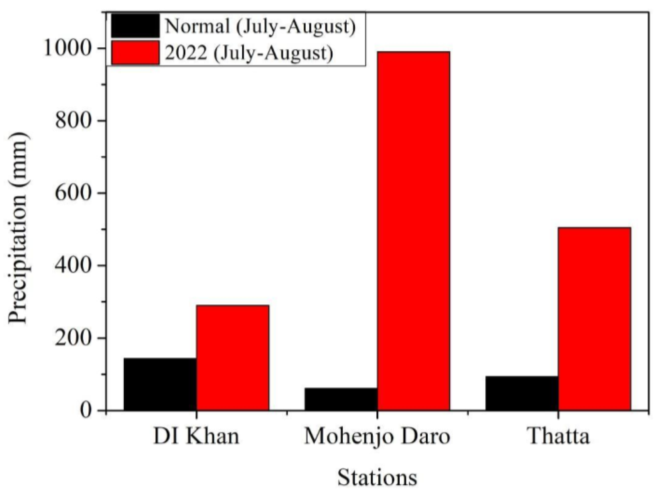
1.2. The 2022 Pakistan Floods and Rapid Mapping Efforts
- Detailed damage assessment for flood-affected heritage sites, as a short-term activity (up to 12 months), with priority 1 (i.e., the highest);
- Data collection on the impact on cultural professionals and specific recovery needs for each region and cultural practice, as a short-to-intermediate-term activity (from up to 12 months to up to 3 years), with priority 2;
- Capacity building of heritage management staff, as an intermediate-to-long-term activity (from up to 3 years to up to 5 years), with priority 2.
2. Materials and Methods
2.1. Rationale
- Multidisciplinary collaboration;
- End-user-driven approach;
- Exploitation of open-access satellite data and derived products made available in format that facilitate their utilization by end-users.
2.2. Methodology
2.2.1. Multidisciplinary Collaboration
2.2.2. End-Users
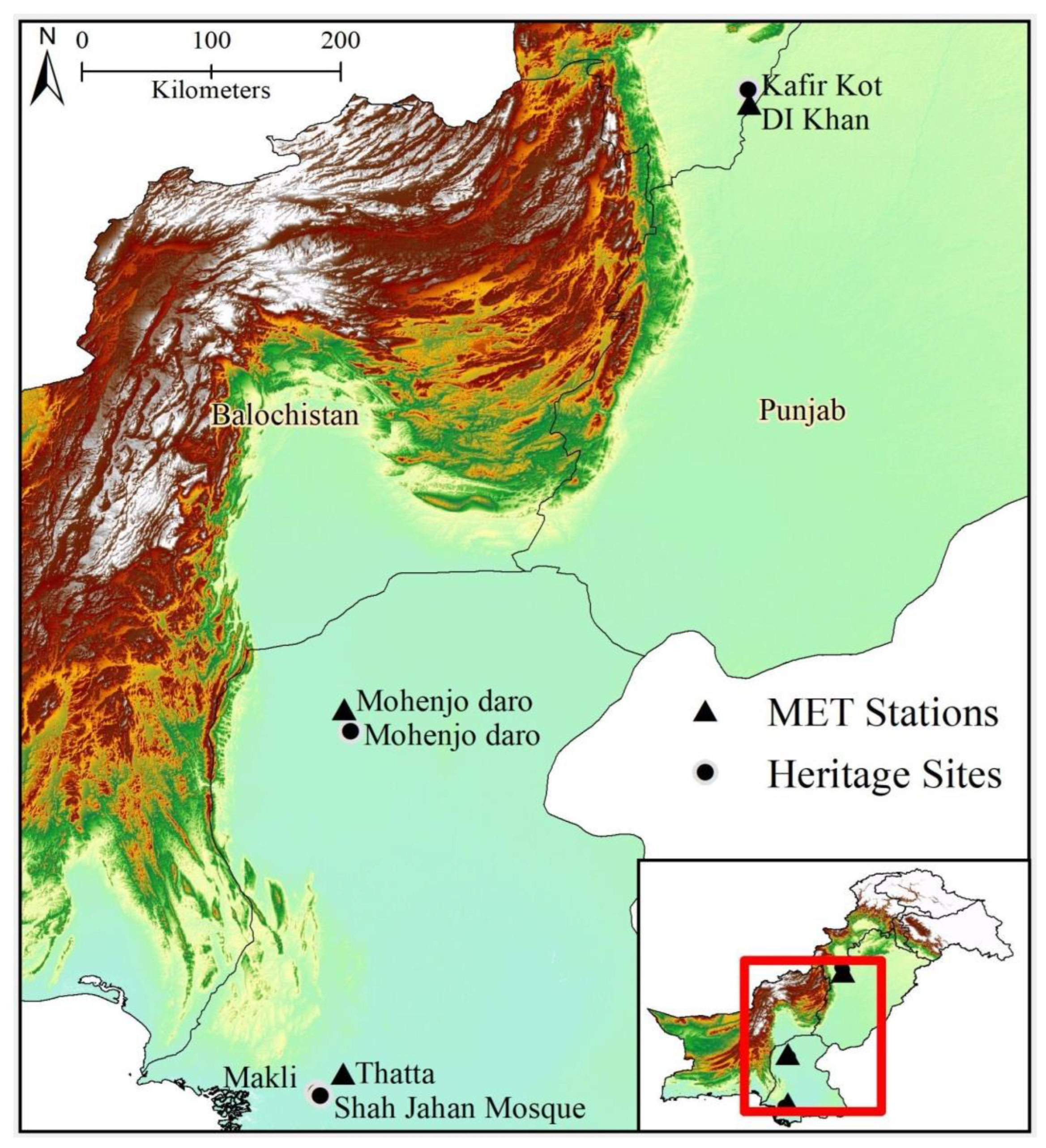
2.3. Case Studies
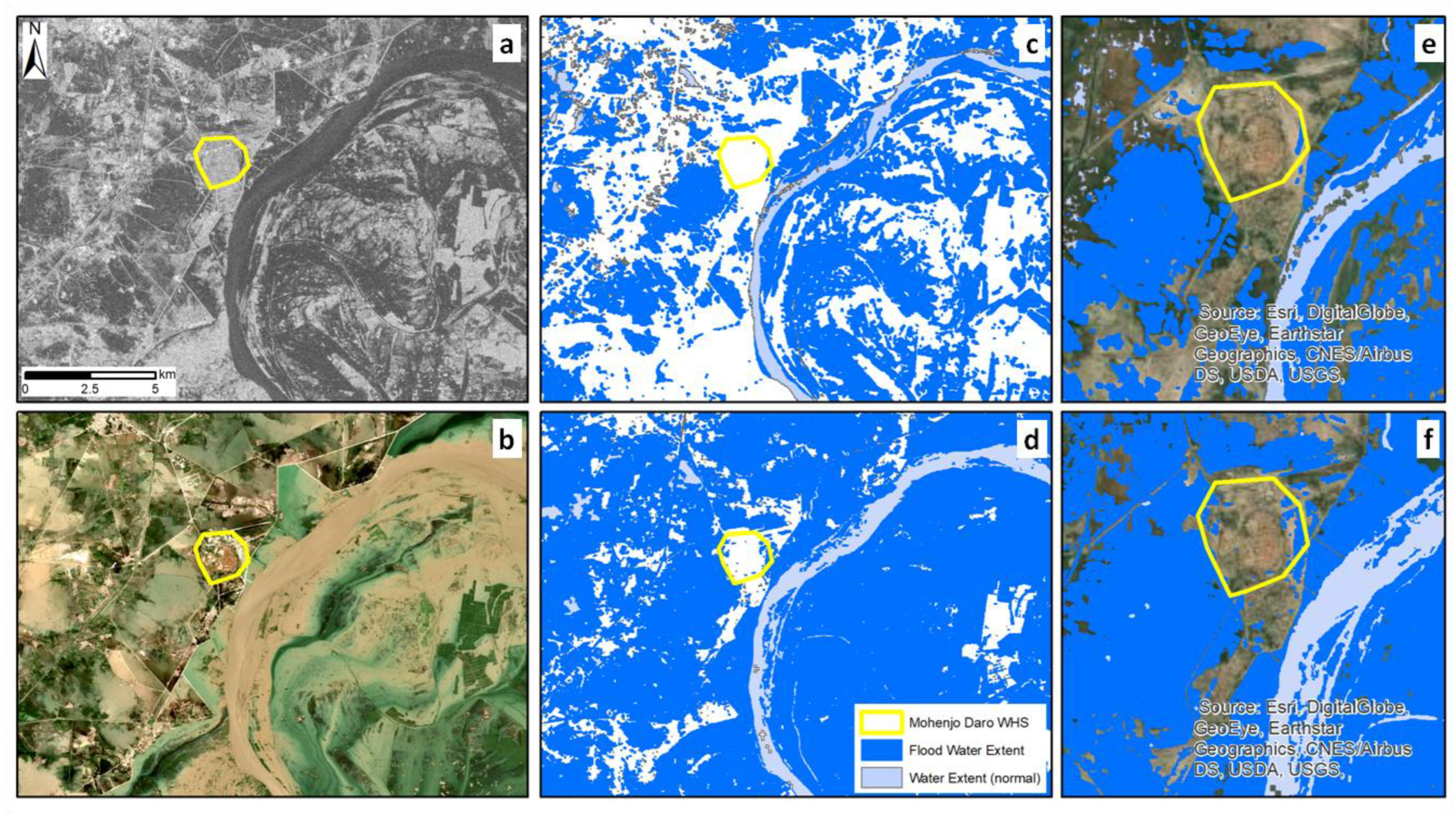
2.3.1. Mohenjo Daro
2.3.2. Makli Necropolis
2.3.3. Shah Jahan Mosque of Thatta
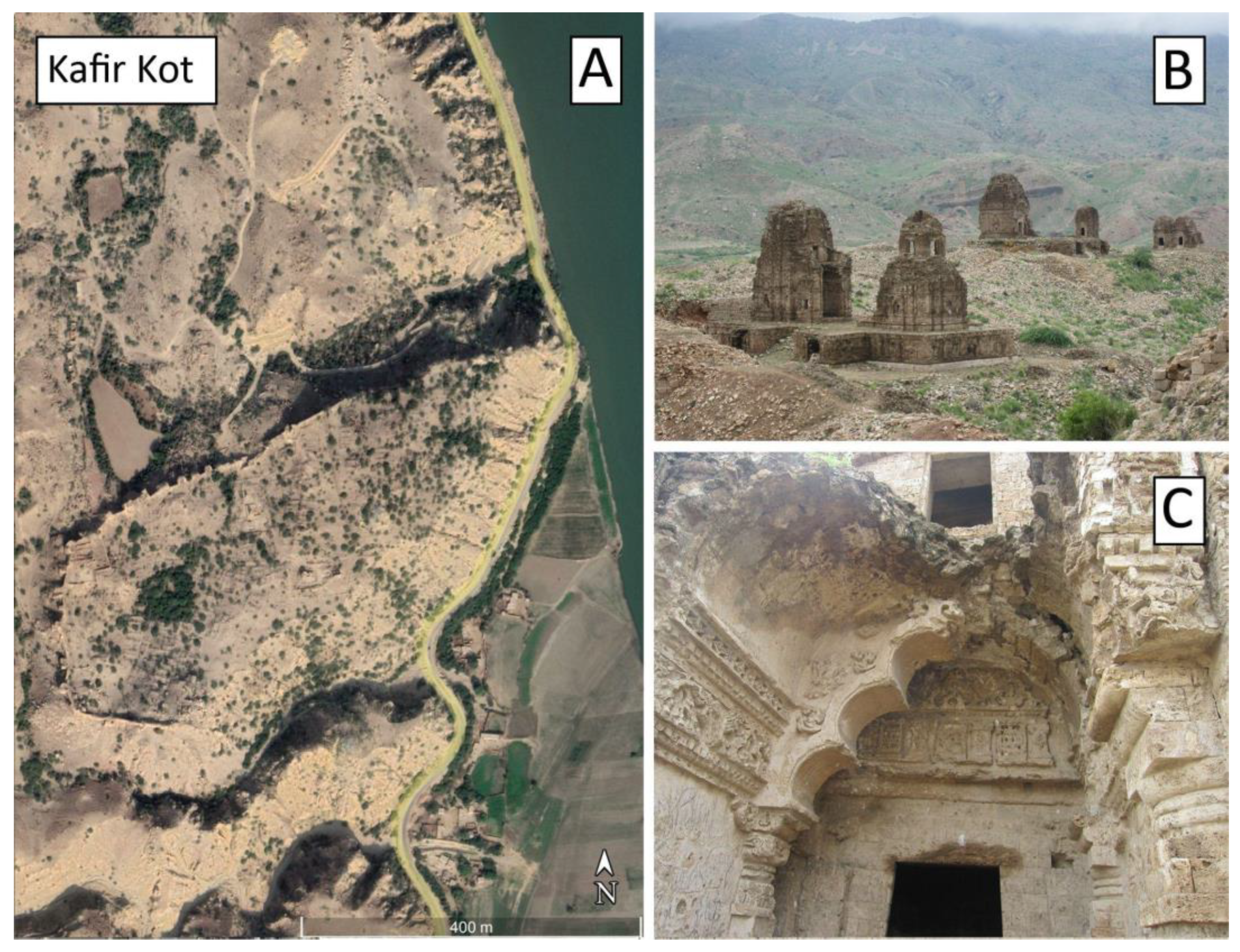
2.3.4. Kafir Kot
2.4. Satellite Data and Derived Products
- Sentinel-1 Observed Flood Extent, i.e., the flooded areas mapped using Sentinel-1 SAR backscatter intensity;
- Sentinel-1 Observed Water Extent, i.e., the open and calm water mapped as the union of the output layers Sentinel-1 Observed Flood Extent and Sentinel-1 Reference Water Mask;
- Sentinel-1 Reference Water Mask Normal (i.e., permanent, seasonal) water mapped using Sentinel-1 SAR backscatter intensity.
- Satellite-detected water extent in Sindh Province, Pakistan as of 31 August 2022;
- Preliminary Satellite-Derived Flood Evolution Assessment, Islamic Republic of Pakistan—9 September 2022;
- Preliminary satellite-derived flood assessment, Islamic Republic of Pakistan—8 September 2022;
- Satellite-detected water extents between 1 and 7 September 2022 over Pakistan;
- Satellite-detected flood extents comparison: 2010 versus 2022.
2.5. Cartographic Data
2.6. Ground-Truthing
3. Results
3.1. Remote Sensing and Cartography
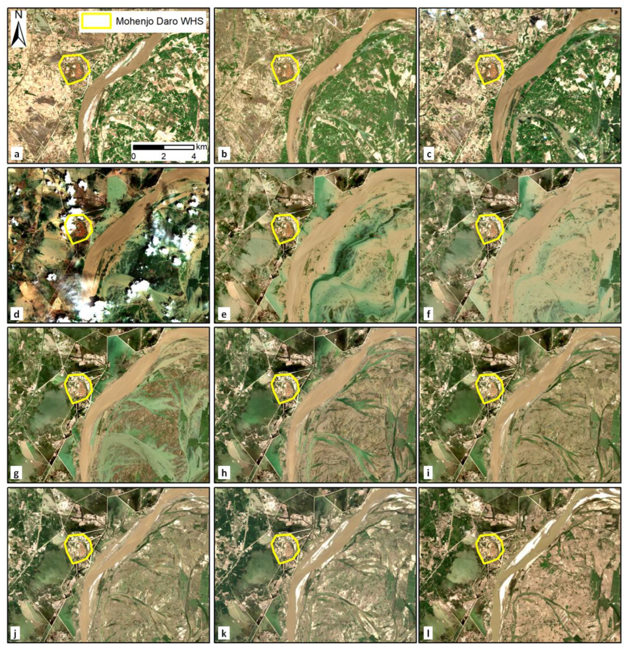
3.1.1. Mohenjo Daro
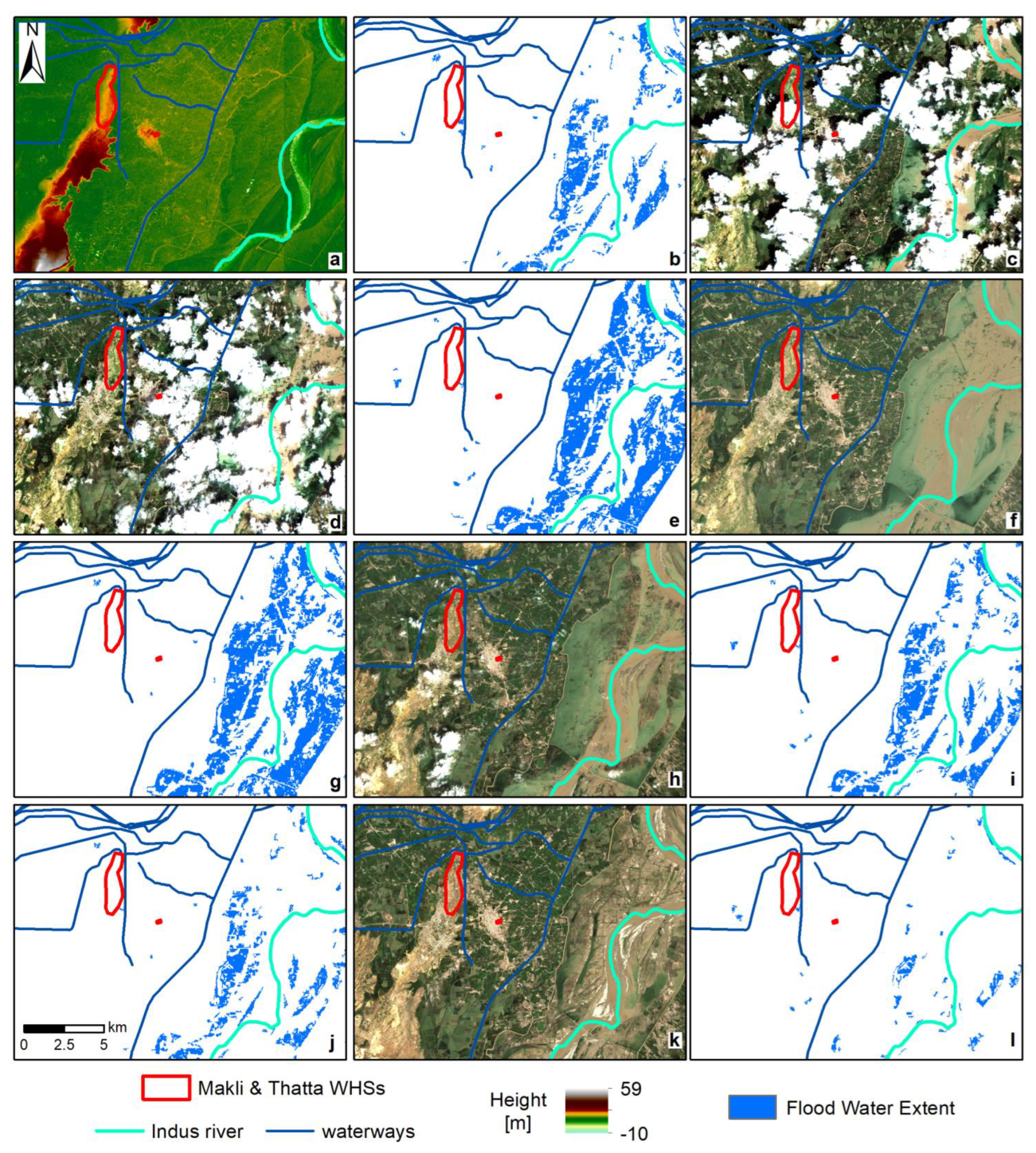
3.1.2. Makli Necropolis and Thatta Mosque
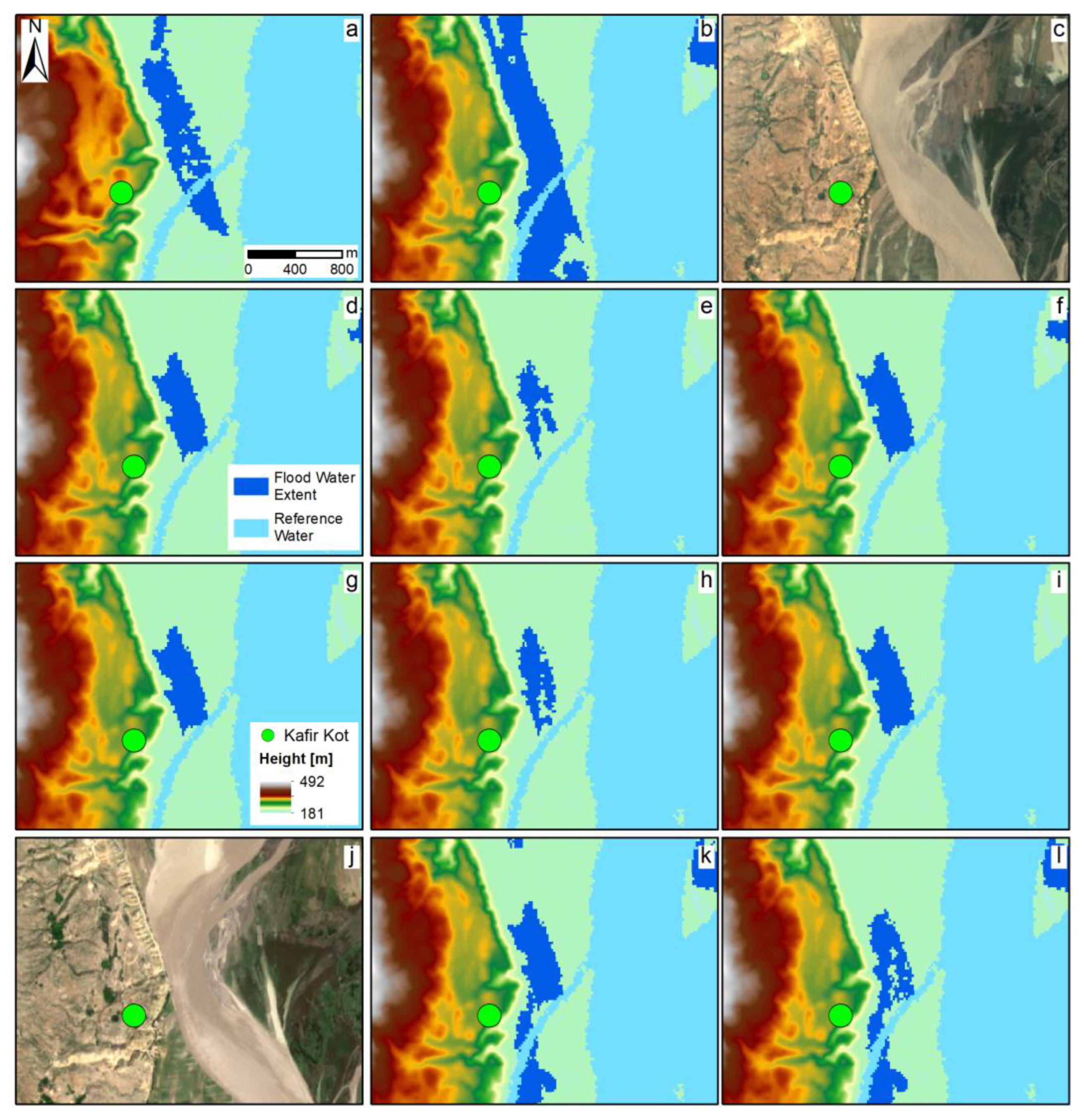
3.1.3. Kafir Kot
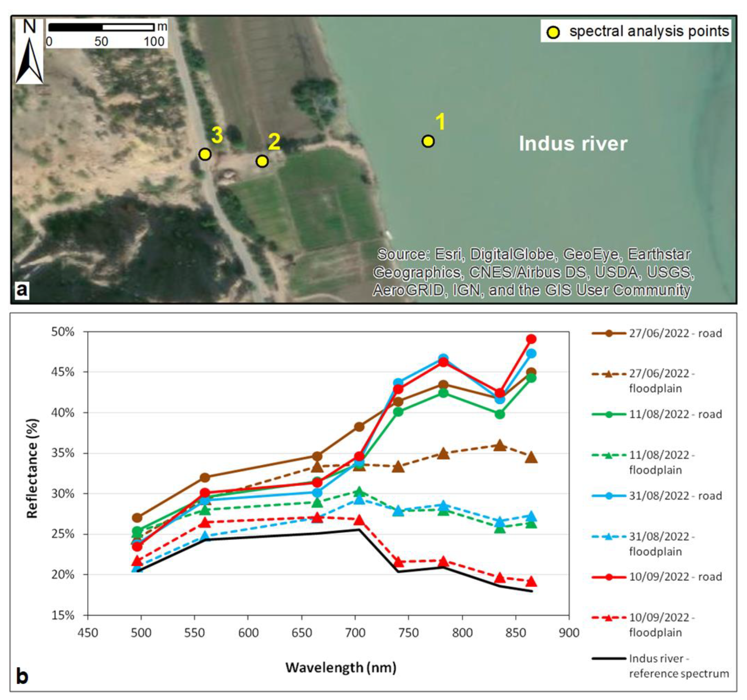
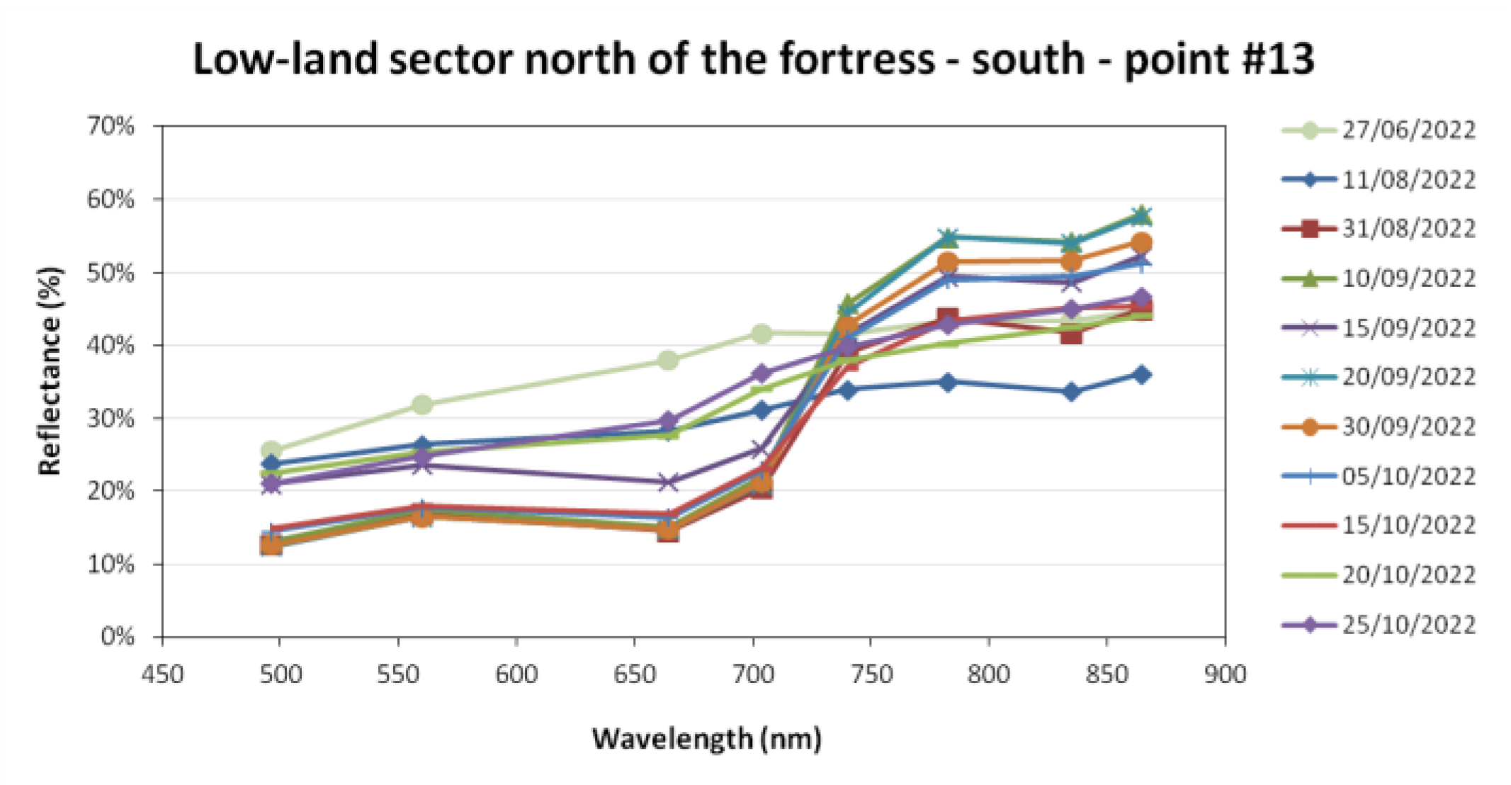
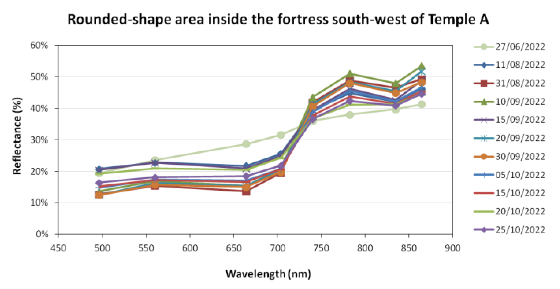
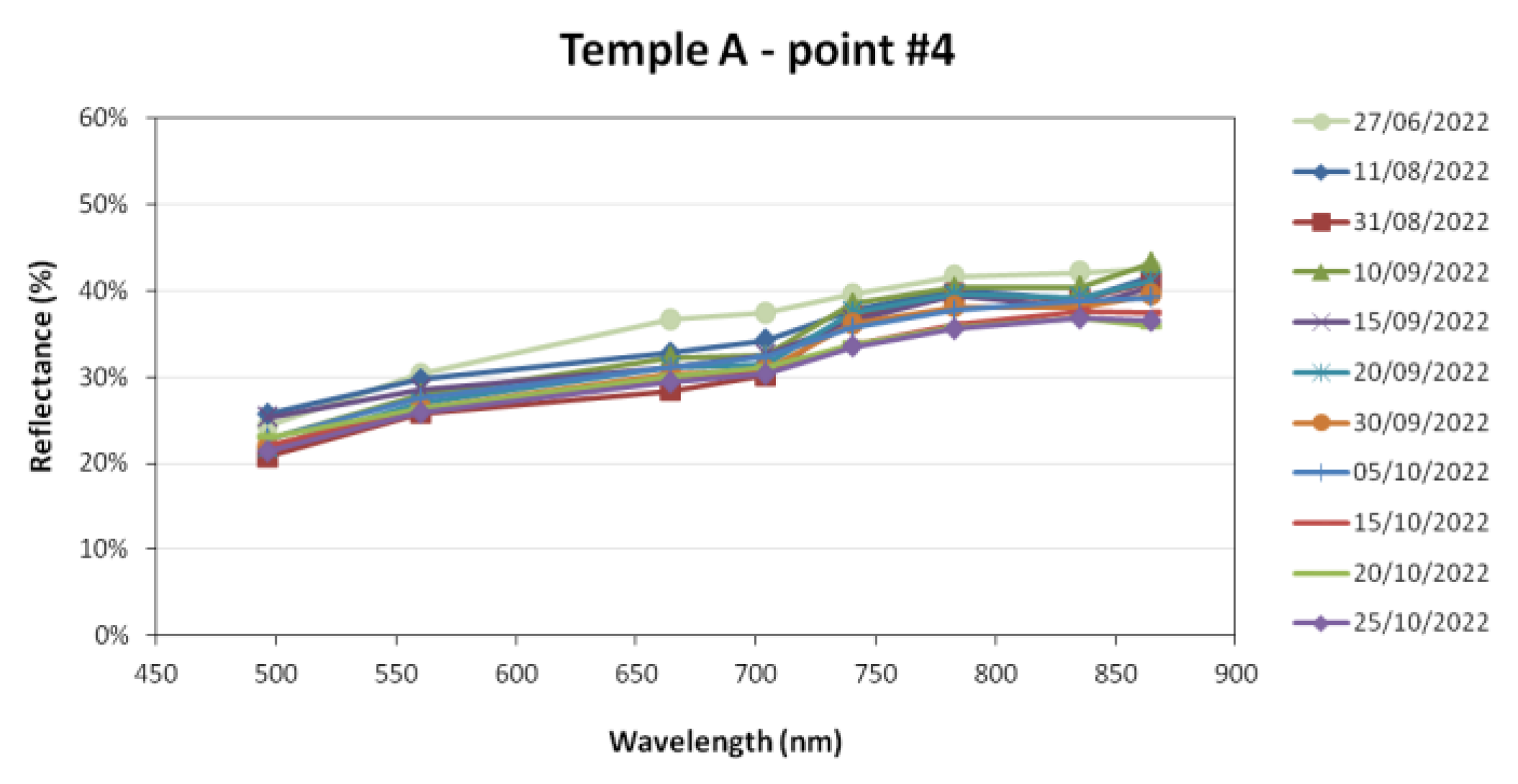
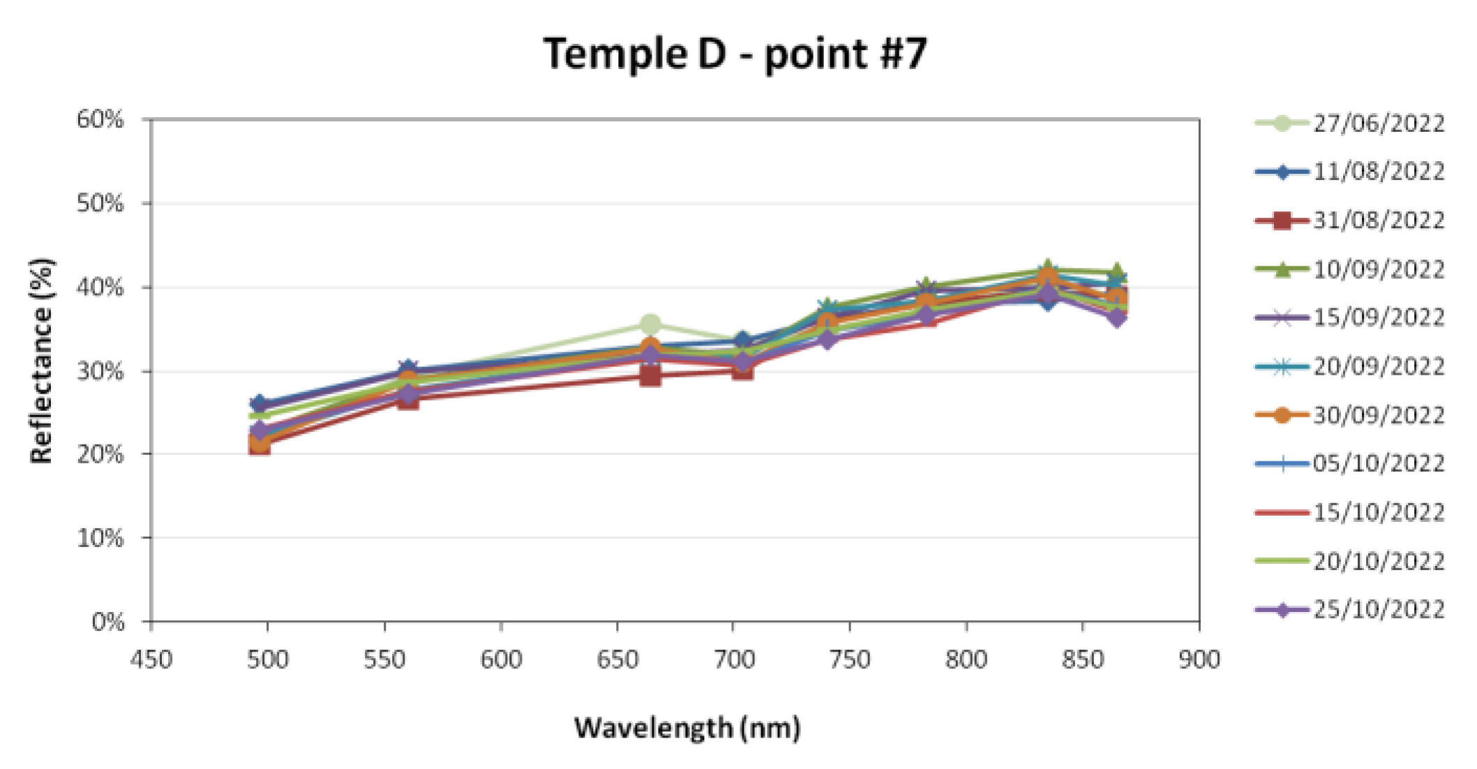
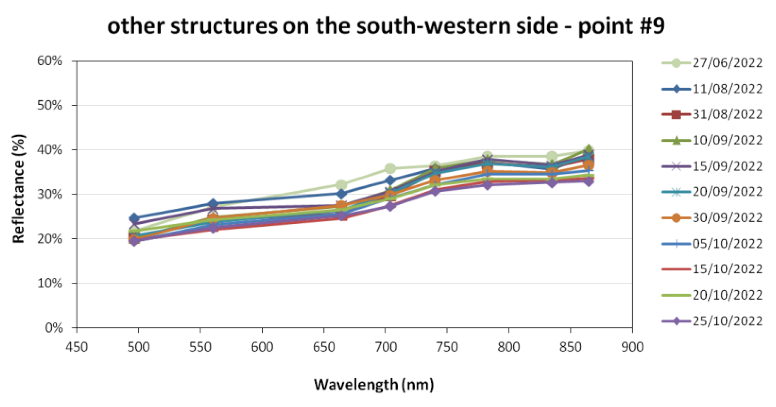
3.2. Ground-Truthing
3.2.1. Mohenjo Daro
3.2.2. Makli Necropolis
3.2.3. Shah Jahan Mosque of Thatta
3.2.4. Kafir Kot
4. Discussion
4.1. Multidisciplinary Collaboration
4.2. Types of Source and Data Acquisition Methods
4.3. Site Management
5. Conclusions
Author Contributions
Funding
Data Availability Statement
Acknowledgments
Conflicts of Interest
Appendix A

| Sensor/ Derived Product | Satellite | Format/ Processing Level | Imaging Mode | Polarization | Date of Acquisition | Observation Geometry | Absolute Orbit Number |
|---|---|---|---|---|---|---|---|
| Sentinel-1/GFM | S1A | GRD/raster | IW | VV | 30 August 2022 | descending | 44775 |
| 3 September 2022 | ascending | 44841 | |||||
| 4 September 2022 | descending | 44848 | |||||
| 6 September 2022 | descending | 44877 | |||||
| 8 September 2022 | ascending | 44914 | |||||
| 11 September 2022 | descending | 44950 | |||||
| 15 September 2022 | ascending | 45016 | |||||
| 18 September 2022 | descending | 45052 | |||||
| 20 September 2022 | ascending | 45089 | |||||
| 23 September 2022 | descending | 45125 | |||||
| 27 September 2022 | ascending | 45191 | |||||
| 30 September 2022 | descending | 45227 | |||||
| 2 October 2022 | ascending | 45264 |
| Satellite | Format/Processing Level | Date of Acquisition | Tile |
|---|---|---|---|
| S2A | L2A | 2 July 2022 | T42RVR |
| S2A | 12 July 2022 | ||
| S2A | 1 August 2022 | ||
| S2A | 11 August 2022 | ||
| S2B | 26 August 2022 | ||
| S2A | 31 August 2022 | ||
| S2B | 5 September 2022 | ||
| S2A | 10 September 2022 | ||
| S2B | 15 September 2022 | ||
| S2A | 20 September 2022 | ||
| S2B | 25 September 2022 | ||
| S2B | 5 October 2022 | ||
| S2A | 10 October 2022 | ||
| S2B | 15 October 2022 | ||
| S2A | 20 October 2022 | ||
| S2B | 25 October 2022 | ||
| S2A | 30 October 2022 |
| Sensor/ Derived Product | Satellite | Format/ Processing Level | Imaging Mode | Polarization | Date of Acquisition | Observation Geometry | Absolute Orbit Number |
|---|---|---|---|---|---|---|---|
| Sentinel-1/GFM | S1A | GRD/raster | IW | VV | 30 August 2022 | descending | 44775 |
| 3 September 2022 | ascending | 44841 | |||||
| 4 September 2022 | descending | 44848 | |||||
| 6 September 2022 | descending | 44877 | |||||
| 8 September 2022 | ascending | 44914 | |||||
| 11 September 2022 | descending | 44950 | |||||
| 15 September 2022 | ascending | 45016 | |||||
| 18 September 2022 | descending | 45052 | |||||
| 20 September 2022 | ascending | 45089 | |||||
| 23 September 2022 | descending | 45125 | |||||
| 27 September 2022 | ascending | 45191 | |||||
| 30 September 2022 | descending | 45227 | |||||
| 2 October 2022 | ascending | 45264 |
| Satellite | Format/Processing Level | Date of Acquisition | Tile |
|---|---|---|---|
| S2B | L2A | 27 June 2022 | T42RUN |
| S2A | 22 July 2022 | ||
| S2A | 31 August 2022 | ||
| S2B | 5 September 2022 | ||
| S2A | 10 September 2022 | ||
| S2A | 20 September 2022 | ||
| S2A | 30 September 2022 | ||
| S2B | 5 October 2022 | ||
| S2A | 10 October 2022 | ||
| S2B | 15 October 2022 | ||
| S2B | 25 October 2022 |
| Sensor/ Derived Product | Satellite | Format/ Processing Level | Imaging Mode | Polarization | Date of Acquisition | Observation Geometry | Absolute Orbit Number |
|---|---|---|---|---|---|---|---|
| Sentinel-1/GFM | S1A | GRD/raster | IW | VV | 1 August 2022 | descending | 44352 |
| 5 August 2022 | ascending | 44418 | |||||
| 12 August 2022 | ascending | 44520 | |||||
| 13 August 2022 | descending | 44527 | |||||
| 17 August 2022 | ascending | 44593 | |||||
| 24 August 2022 | ascending | 44695 | |||||
| 25 August 2022 | descending | 44702 | |||||
| 5 September 2022 | ascending | 44870 | |||||
| 6 September 2022 | descending | 44877 | |||||
| 10 September 2022 | ascending | 44943 | |||||
| 17 September 2022 | ascending | 45045 | |||||
| 22 September 2022 | descending | 45052 | |||||
| 29 September 2022 | ascending | 45118 | |||||
| 30 September 2022 | ascending | 45220 | |||||
| 4 October 2022 | descending | 45227 | |||||
| 11 October 2022 | ascending | 45293 | |||||
| 12 October 2022 | ascending | 45395 | |||||
| 23 October 2022 | descending | 45402 | |||||
| 1 August 2022 | ascending | 45570 |
| Satellite | Format/Processing Level | Date of Acquisition | Tile |
|---|---|---|---|
| S2B | L2A | 27 June 2022 | T42SYA, T42SYB |
| S2A | 11 August 2022 | ||
| S2A | 31 August 2022 | ||
| S2A | 10 September 2022 | ||
| S2B | 15 September 2022 | ||
| S2A | 20 September 2022 | ||
| S2A | 30 September 2022 | ||
| S2B | 5 October 2022 | ||
| S2B | 15 October 2022 | ||
| S2A | 20 October 2022 | ||
| S2B | 25 October 2022 | ||
| S2B | 4 November 2022 | ||
| S2B | 24 November 2022 | ||
| S2A | 29 November 2022 | ||
| S2A | 9 December2022 |
Appendix B


References
- Pryor, S.C.; Howe, J.A.; Kunkel, K.E. How spatially coherent and statistically robust are temporal changes in extreme precipitation in the contiguous USA? Int. J. Climatol. 2009, 29, 31–45. [Google Scholar] [CrossRef]
- Merz, B.; Blöschl, G.; Vorogushyn, S.; Dottori, F.; Aerts, J.C.J.H.; Bates, P.; Bertola, M.; Kemter, M.; Kreibich, H.; Lall, U.; et al. Causes, impacts and patterns of disastrous river floods. Nat. Rev. Earth Environ. 2021, 2, 592–609. [Google Scholar] [CrossRef]
- World Food Programme. Pakistan Flood Impact Assessment, September 2010—Pakistan|ReliefWeb; United Nations—World Food Programme: New York, 2010; Available online: https://documents.wfp.org/stellent/groups/public/documents/ena/wfp225987.pdf (accessed on 2 February 2023).
- Immigration and Refugeee Board of Canada. The Impact of the 2010 and 2011 Floods, Including on Mobility, Reconstruction, Housing and Shelter, Employment and Access to Food, 1 December 2011, PAK103865.E. Available online: https://www.refworld.org/docid/5072cc582.html (accessed on 2 February 2023).
- Kirsch, T.D.; Wadhwani, C.; Sauer, L.; Doocy, S.; Catlett, C. Impact of the 2010 Pakistan Floods on Rural and Urban Populations at Six Months. PLoS Curr. 2012, 4. [Google Scholar] [CrossRef] [PubMed]
- Abro, M.I.; Zhu, D.; Ali Khaskheli, M.; Elahi, E.; Aleem ul Hassan Ramay, M. Statistical and qualitative evaluation of multi-sources for hydrological suitability inflood-prone areas of Pakistan. J. Hydrol. 2020, 588, 125117. [Google Scholar] [CrossRef]
- Rasool, S.; Rana, I.A.; Ahmad, S. Linking flood risk perceptions and psychological distancing to climate change: A case study of rural communities along Indus and Chenab rivers, Pakistan. Int. J. Disaster Risk Reduct. 2022, 70, 102787. [Google Scholar] [CrossRef]
- Otto, F.E.; Zachariah, M.; Saeed, F.; Siddiqi, A.; Shahzad, K.; Mushtaq, H.; Arulalan, T.; Krishna, A.R.; Chaithra, S.T.; Clair, B.; et al. Climate Change Likely Increased Extreme Monsoon Rainfall, Flooding Highly Vulnerable Communities in Pakistan—World Weather Attribution; Utrecht University Repository: Utrecht, The Netherlands, 2022. [Google Scholar]
- Hegyi, A.; Agapiou, A. Rapid Assessment of 2022 Floods around the UNESCO Site of Mohenjo-Daro in Pakistan by Using Sentinel and Planet Labs Missions. Sustainability 2023, 15, 2084. [Google Scholar] [CrossRef]
- Arrighi, C. A Global Scale Analysis of River Flood Risk of UNESCO World Heritage Sites. Front. Water 2021, 3, 764459. [Google Scholar] [CrossRef]
- Voigt, S.; Giulio-Tonolo, F.; Lyons, J.; Kučera, J.; Jones, B.; Schneiderhan, T.; Platzeck, G.; Kaku, K.; Hazarika, M.K.; Czaran, L.; et al. Global trends in satellite-based emergency mapping. Science 2016, 353, 247–252. [Google Scholar] [CrossRef]
- Agapiou, A.; Lysandrou, V.; Hadjimitsis, D.G. Earth observation contribution to cultural heritage disaster risk management: Case study of Eastern Mediterranean open air archaeological monuments and sites. Remote Sens. 2020, 12, 1330. [Google Scholar] [CrossRef]
- Copernicus Services in Support to Cultural Heritage—Publications Office of the EU. Available online: https://op.europa.eu/en/publication-detail/-/publication/220f385f-76bd-11e9-9f05-01aa75ed71a1/ (accessed on 19 February 2023).
- Alfieri, L.; Bisselink, B.; Dottori, F.; Naumann, G.; de Roo, A.; Salamon, P.; Wyser, K.; Feyen, L. Global projections of river flood risk in a warmer world. Earth’s Futur. 2017, 5, 171–182. [Google Scholar] [CrossRef]
- Kulp, S.A.; Strauss, B.H. New elevation data triple estimates of global vulnerability to sea-level rise and coastal flooding. Nat. Commun. 2019, 10, 4844. [Google Scholar] [CrossRef] [PubMed]
- Haq, M.; Akhtar, M.; Muhammad, S.; Paras, S.; Rahmatullah, J. Techniques of Remote Sensing and GIS for flood monitoring and damage assessment: A case study of Sindh province, Pakistan. Egypt. J. Remote Sens. Space Sci. 2012, 15, 135–141. [Google Scholar] [CrossRef]
- Memon, A.A.; Muhammad, S.; Rahman, S.; Haq, M. Flood monitoring and damage assessment using water indices: A case study of Pakistan flood-2012. Egypt. J. Remote Sens. Space Sci. 2015, 18, 99–106. [Google Scholar] [CrossRef]
- Qamer, F.M.; Ahmad, B.; Abbas, S.; Hussain, A.; Salman, A.; Muhammad, S.; Nawaz, M.; Shrestha, S.; Iqbal, B.; Thapa, S. The 2022 Pakistan Floods: Assessment of Crop Losses in Sindh Province using Satellite Data; International Centre for Integrated Mountain Development (ICIMOD); Pakistan Agricultural Research Council’s (PARC): Kathmandu, Nepal, 2022. [Google Scholar] [CrossRef]
- Haq, M.; Said, R.; Rahmatullah, J.; Mohammad, S. Pakistan—Flood 2010 monitoring using MODIS data. In Proceedings of the 9th International Workshop of the CAS-TWAS-W Forum (2010 CTWF) on Climate and Environmental Changes and Challenges for Developing Countries, Beijing, China, 17–19 November 2010; Chinese Academy of Science: Beijing, China, 2010; pp. 17–20. [Google Scholar]
- Mirza, M.M.Q. Climate change, flooding in South Asia and implications. Reg. Environ. Chang. 2011, 11, 95–107. [Google Scholar] [CrossRef]
- Pakistan Floods 2022: Post-Disaster Needs Assessment (PDNA)|United Nations Development Programme. Available online: https://www.undp.org/pakistan/publications/pakistan-floods-2022-post-disaster-needs-assessment-pdna (accessed on 19 February 2023).
- UNESCO. Climate Change and World Heritage: Report on predicting and managing the impacts of climate change on World Heritage and strategy to assist State Parties to implement appropriate management responses. World Herit. Rep. 2007, 22, 1–55. [Google Scholar]
- Sabbioni, C.; Brimblecombe, P.; Cassar, M. The Atlas of Climate Change Impact on European Cultural Heritage—Publications Office of the EU; Anthem Press: London, UK, 2010; ISBN 978-92-79-09800-0. [Google Scholar]
- UNESCO. UNESCO World Heritage Centre—Document—State of Conservation of World Heritage Properties—A Statistical Analysis (1979–2013). Available online: https://whc.unesco.org/en/documents/134872 (accessed on 19 February 2023).
- UNESCO. Enhancing our Heritage Toolkit, Assessing Management Effectiveness of Natural. Available online: https://whc.unesco.org/en/series/23/ (accessed on 19 February 2023).
- UNOSAT. Preliminary Satellite-Derived Flood Assessment, Islamic Republic of Pakistan—8 September 2022. Available online: https://unosat.org/products/3352 (accessed on 19 February 2023).
- Mapping. COPERNICUS EMERGENCY MANAGEMENT SERVICE|Copernicus EMS—EMSR629: Floods in Pakistan. Available online: https://emergency.copernicus.eu/mapping/list-of-components/EMSR629 (accessed on 19 February 2023).
- Zaina, F.; Tapete, D. Satellite-Based Methodology for Purposes of Rescue Archaeology of Cultural Heritage Threatened by Dam Construction. Remote Sens. 2022, 14, 1009. [Google Scholar] [CrossRef]
- Agapiou, A.; Lysandrou, V. Remote sensing archaeology: Tracking and mapping evolution in European scientific literature from 1999 to 2015. J. Archaeol. Sci. Reports 2015, 4, 192–200. [Google Scholar] [CrossRef]
- Cunliffe, E.L.; de Gruchy, M.W.; Stammitti, E. Project {Development}—{Dam}(ned) archaeology. Int. Water Power Dam Constr. 2012, 64, 9. [Google Scholar]
- Khan, M.Y.; Zaina, F.; ul Abedin, Z.; Tariq, S.; Khan, M.J. Evaluation of risks to UNESCO World Heritage (WH) sites in Taxila, Pakistan using ground-based and satellite remote sensing techniques. J. Cult. Herit. 2022, 55, 195–209. [Google Scholar] [CrossRef]
- Possehl, G.L. The Indus Civilization: A Contemporary Perspective; Altamira Press: Walnut Creek, 2002. [Google Scholar]
- McIntosh, J. The Ancient Indus Valley: New Perspectives; ABC-CLIO: Santa Barbara, 2008. [Google Scholar]
- UNESCO. Archaeological Ruins at Moenjodaro—Gallery—UNESCO World Heritage Centre. Available online: https://whc.unesco.org/en/list/138/gallery/ (accessed on 19 February 2023).
- Marshall, J. Mohenjo-Daro and the Indus Civilization: Being an Official Account of Archaeological Excavations at Mohenjo-Daro Carried Out by the Government of India between the Years 1922 and 1927; Arthur Probsthain: London, UK, 1931. [Google Scholar]
- Mackay, E. Further Excavations at Mohenjo-Daro Being an Official Account of Archaeological Excavations at Mohenjo-Daro Carried out by the Government of India between the Years 1927- and 1931 Vol.I: Text|INDIAN CULTURE. Available online: https://indianculture.gov.in/ebooks/further-excavations-mohenjo-daro-being-official-account-archaeological-excavations-mohenjo-0 (accessed on 19 February 2023).
- UNESCO. UNESCO World Heritage Centre—State of Conservation (SOC) Search. Available online: https://whc.unesco.org/en/soc/?action=list&id_site=138 (accessed on 19 February 2023).
- UNESCO. UNESCO World Heritage Centre—List of Factors Affecting the Properties. Available online: https://whc.unesco.org/en/factors/ (accessed on 19 February 2023).
- UNESCO. UNESCO World Heritage Centre—State of Conservation (SOC 1991) Archaeological Ruins at Moenjodaro (Pakistan). Available online: https://whc.unesco.org/en/soc/1643 (accessed on 19 February 2023).
- UNESCO. UNESCO World Heritage Centre—State of Conservation (SOC 1995) Archaeological Ruins at Moenjodaro (Pakistan). Available online: https://whc.unesco.org/en/soc/2989 (accessed on 19 February 2023).
- UNESCO. UNESCO World Heritage Centre—State of Conservation (SOC 1997) Archaeological Ruins at Moenjodaro (Pakistan). Available online: https://whc.unesco.org/en/soc/2147 (accessed on 19 February 2023).
- UNESCO. UNESCO World Heritage Centre—State of Conservation (SOC 2006) Archaeological Ruins at Moenjodaro (Pakistan). Available online: https://whc.unesco.org/en/soc/1189 (accessed on 19 February 2023).
- UNESCO. UNESCO World Heritage Centre—State of Conservation (SOC 2007) Archaeological Ruins at Moenjodaro (Pakistan). Available online: https://whc.unesco.org/en/soc/1028 (accessed on 19 February 2023).
- UNESCO. UNESCO World Heritage Centre—State of Conservation (SOC 2011) Archaeological Ruins at Moenjodaro (Pakistan). Available online: https://whc.unesco.org/en/soc/403 (accessed on 19 February 2023).
- Hasan, S.K. The Islamic Architectural Heritage of Pakistan: Funerary Memorial Architecture; Royal Book Company: Karachi, Pakistan, 2001. [Google Scholar]
- Qasim, A.Q. Makli Hill Monuments Thatta: History, Architecture, Conservation. J. Res. Archit. Plan. 2014, 14, 55–67. Available online: https://jrap.neduet.edu.pk/arch-journal/JRAP_2014(FirstIssue)/05.pdf (accessed on 1 February 2023).
- UNESCO. Historical Monuments at Makli, Thatta—Gallery—UNESCO World Heritage Centre. Available online: https://whc.unesco.org/en/list/143/gallery/ (accessed on 19 February 2023).
- UNESCO. UNESCO World Heritage Centre—State of Conservation (SOC 2006) Historical Monuments at Makli, Thatta (Pakistan). Available online: https://whc.unesco.org/en/soc/1188 (accessed on 19 February 2023).
- UNESCO UNESCO World Heritage Centre—State of Conservation (SOC 2007) Historical Monuments at Makli, Thatta (Pakistan). Available online: https://whc.unesco.org/en/soc/1027 (accessed on 19 February 2023).
- UNESCO. UNESCO World Heritage Centre—State of Conservation (SOC 2009) Historical Monuments at Makli, Thatta (Pakistan). Available online: https://whc.unesco.org/en/soc/682 (accessed on 19 February 2023).
- UNESCO. UNESCO World Heritage Centre—State of Conservation (SOC 2011) Historical Monuments at Makli, Thatta (Pakistan). Available online: https://whc.unesco.org/en/soc/402 (accessed on 19 February 2023).
- UNESCO. UNESCO World Heritage Centre—State of Conservation (SOC 2012) Historical Monuments at Makli, Thatta (Pakistan). Available online: https://whc.unesco.org/en/soc/120 (accessed on 19 February 2023).
- UNESCO. UNESCO World Heritage Centre—State of Conservation (SOC 2013) Historical Monuments at Makli, Thatta (Pakistan). Available online: https://whc.unesco.org/en/soc/1902 (accessed on 19 February 2023).
- UNESCO. UNESCO World Heritage Centre—State of Conservation (SOC 2015) Historical Monuments at Makli, Thatta (Pakistan). Available online: https://whc.unesco.org/en/soc/3286 (accessed on 19 February 2023).
- UNESCO. UNESCO World Heritage Centre—State of Conservation (SOC 2016) Historical Monuments at Makli, Thatta (Pakistan). Available online: https://whc.unesco.org/en/soc/3419 (accessed on 19 February 2023).
- UNESCO. UNESCO World Heritage Centre—State of Conservation (SOC 2017) Historical Monuments at Makli, Thatta (Pakistan). Available online: https://whc.unesco.org/en/soc/3646 (accessed on 19 February 2023).
- UNESCO. UNESCO World Heritage Centre—State of Conservation (SOC 2019) Historical Monuments at Makli, Thatta (Pakistan). Available online: https://whc.unesco.org/en/soc/3956 (accessed on 19 February 2023).
- UNESCO. UNESCO World Heritage Centre—State of Conservation (SOC 2021) Historical Monuments at Makli, Thatta (Pakistan). Available online: https://whc.unesco.org/en/soc/4089 (accessed on 19 February 2023).
- UNESCO. Historical Monuments at Makli, Thatta—Documents—UNESCO World Heritage Centre—Documents. Available online: https://whc.unesco.org/en/list/143/documents/ (accessed on 19 February 2023).
- Khazeni, A. Sky Blue Stone: The Turquoise Trade in World History; University of California Press: Berkeley, CA, USA, 2014; ISBN 9780520282551. [Google Scholar]
- Kaplan, R.D. Monsoon: The Indian Ocean and the Future of American Power; Random House Trade Paperbacks: New York, 2010; p. 366. [Google Scholar]
- Khan, A.N.; Nisar, A.; Olivieri, L.M.; Vitali, M. The Recent Discovery of Cave Paintings in Swat A Preliminary Note. East West 1995, 45, 333–353. [Google Scholar]
- Olivieri, L.M. Hanging Rocks and ‘Intoxicating Drinks’: The Rock Art Sequence of the Swat Valley. South Asian Stud. 2008, 24, 15–26. [Google Scholar] [CrossRef]
- Khan, B.; Iqbal, M.J.; Yosufzai, M.A.K. Flood risk assessment of River Indus of Pakistan. Arab. J. Geosci. 2011, 4, 115–122. [Google Scholar] [CrossRef]
- WAPDA. Chashma Barrage. Available online: http://www.wapda.gov.pk/index.php/projects/hydro-power/o-m/chashma/item/354-chashma-barrage (accessed on 19 February 2023).
- Tapete, D.; Cigna, F. Appraisal of opportunities and perspectives for the systematic condition assessment of heritage sites with copernicus Sentinel-2 high-resolution multispectral imagery. Remote Sens. 2018, 10, 561. [Google Scholar] [CrossRef]
- ESA. User Guides—Sentinel-1 SAR—Level-1 Ground Range Detected—Sentinel Online—Sentinel Online. Available online: https://sentinels.copernicus.eu/web/sentinel/user-guides/sentinel-1-sar/resolutions/level-1-ground-range-detected (accessed on 5 February 2022).
- EODC GFM. Product Output Layers|EODC Public Wiki. Available online: https://extwiki.eodc.eu/GFM/PUM/Products (accessed on 19 February 2023).
- Salamon, P.; Mctlormick, N.; Reimer, C.; Clarke, T.; Bauer-Marschallinger, B.; Wagner, W.; Martinis, S.; Chow, C.; Böhnke, C.; Matgen, P.; et al. The New, Systematic Global Flood Monitoring Product of the Copernicus Emergency Management Service. In Proceedings of the 2021 IEEE International Geoscience and Remote Sensing Symposium IGARSS, Brussels, Belgium, 11–16 July 2021; Institute of Electrical and Electronics Engineers: Red Hook, NY, USA, 2021; pp. 1053–1056. [Google Scholar]
- Matgen, P.; Martinis, S.; Wagner, W.; Freeman, V.; Zeil, P.; McCormick, N.; European Commission; Joint Research Centre. Feasibility Assessment of an Automated, Global, Satellite-Based Flood Monitoring Product for the Copernicus Emergency Management Service; Publications Office of the European Union: Luxembourg, Germany, 2020. [Google Scholar]
- Wagner, W.; Freeman, V.; Cao, S.; Matgen, P.; Chini, M.; Salamon, P.; McCormick, N.; Martinis, S.; Bauer-Marschallinger, B.; Navacchi, C.; et al. Data processing architectures for monitoring floods using Sentinel-1. In ISPRS Annals of the Photogrammetry, Remote Sensing and Spatial Information Sciences; Copernicus Publication: Göttingen, 2020; Volume V-3-2020, pp. 641–648. ISSN 2194-9042. [Google Scholar]
- GDACS. Pakistan Flood, FL1101522, UNOSAT and Copernicus Products. Available online: https://smcs.unosat.org/event/239 (accessed on 19 February 2023).
- Tapete, D.; Cigna, F. Poorly known 2018 floods in Bosra UNESCO site and Sergiopolis in Syria unveiled from space using Sentinel-1/2 and COSMO-SkyMed. Sci. Rep. 2020, 10, 12307. [Google Scholar] [CrossRef]
- Takaku, J.; Tadono, T.; Tsutsui, K. Generation of high resolution global DSM from ALOS PRISM. In International Archives of the Photogrammetry, Remote Sensing and Spatial Information Sciences—ISPRS Archives; Volume XL-4, 2014 ISPRS Technical Commission IV Symposium, 14–16 May 2014, Suzhou, China; Copernicus Publication: Göttingen, 2014; pp. 243–248. [Google Scholar]
- Tadono, T.; Ishida, H.; Oda, F.; Naito, S.; Minakawa, K.; Iwamoto, H. Precise Global DEM Generation by ALOS PRISM. ISPRS Ann. Photogramm. Remote Sens. Spat. Inf. Sci. 2014, 2, 71. [Google Scholar] [CrossRef]
- Pakistan Map and Satellite Image. Available online: https://geology.com/world/pakistan-satellite-image.shtml (accessed on 19 February 2023).
- Magsi, H. Relation of seismicity with surface faults in Pakistan: An overview. NCGT J 2014, 2, 42–55. [Google Scholar]
- Bakr, M.U. Geological Map of Pakistan. (East and West Pakistan); Geological Survey of Pakistan: Islamabad, 1964. [Google Scholar]
- Congalton, R.G.; Green, K. Assessing the Accuracy of Remotely Sensed Data: Principles and Practices; CRC Press: Boca Raton, FL, USA, 2019. [Google Scholar]
- Rayne, L.; Bradbury, J.; Mattingly, D.; Philip, G.; Bewley, R.; Wilson, A. From above and on the ground: Geospatial methods for recording endangered archaeology in the middle East and North Africa. Geosciences 2017, 7, 100. [Google Scholar] [CrossRef]
- Zaina, F. A Risk Assessment for Cultural Heritage in Southern Iraq: Framing Drivers, Threats and Actions Affecting Archaeological Sites. Conserv. Manag. Archaeol. Sites 2019, 21, 184–206. [Google Scholar] [CrossRef]
- Cook, I.; Johnston, R.; Selby, K. Climate Change and Cultural Heritage: A Landscape Vulnerability Framework. J. Isl. Coast. Archaeol. 2021, 16, 553–571. [Google Scholar] [CrossRef]
- Fisher, M.T.; Jurkenas, D.; Jambajantsan, A.; Jamsranjav, B.; Nasan-Ochir, E.O.; Gelegdorj, E.; Chuluunbat, M.; Petraglia, M.; Boivin, N. Multidisciplinary digital methodologies for documentation and preservation of immovable Archaeological heritage in the Khovd River Valley, Western Mongolia [version 1; peer review: Awaiting peer review]. F1000Research 2022, 11, 1250. [Google Scholar] [CrossRef]
- UNOSAT. Satellite Detected Water Extent in Sindh Province, Pakistan as of 31 August 2022. Available online: https://unosat.org/products/3348 (accessed on 19 February 2023).
- Annual Report of the Archaeological Survey of India, 1921-22|INDIAN CULTURE. Available online: https://www.indianculture.gov.in/annual-report-archaeological-survey-india-1921-22 (accessed on 19 February 2023).
- UNESCO. World Heritage Centre—Managing Disaster Risks for World Heritage. Available online: https://whc.unesco.org/en/managing-disaster-risks/ (accessed on 19 February 2023).
- UNESCO. Archaeological Ruins at Moenjodaro—Documents—UNESCO World Heritage Centre. Available online: https://whc.unesco.org/en/list/138/documents/ (accessed on 19 February 2023).
- UNESCO. Managing {Disaster} {Risks}; UNESCO: Paris, France, 2010; Volume 1, ISBN 978-92-3-104165-5. [Google Scholar]
- IPCC Intergovernmental Panel on Climate Change: Climate change 2014: Impacts, adaptation, and vulnerability. Part A: Global and sectoral aspects. In Climate Change 2014: Impacts, Adaptation, and Vulnerability. Part A: Global and Sectoral Aspects; Cambridge University Press: New York, NY, USA, 2014; pp. 1039–1099. [Google Scholar]
- Thomas, V.; López, R. Global Increase in Climate-Related Disasters. SSRN Electron. J. 2016. [Google Scholar] [CrossRef]
- Cuca, B.; Hadjimitsis, D.G. Space technology meets policy: An overview of Earth Observation sensors for monitoring of cultural landscapes within policy framework for Cultural Heritage. J. Archaeol. Sci. Reports 2017, 14, 727–733. [Google Scholar] [CrossRef]
- EDUU Project—EDUU—Education and Cultural Heritage Enhancement for Social Cohesion in Iraq. Available online: https://site.unibo.it/eduu/en/project (accessed on 19 February 2023).
- Bewley, R.; Wilson, A.I.; Kennedy, D.; Mattingly, D.; Banks, R.; Bishop, M. Endangered Archaeology in the Middle East and North Africa: Introducing the EAMENA Project. In Proceedings of the 43rd CAA Annual Conference, Siena, Italy, 31 March –2 April 2015; Archaeopress: Oxford, UK, 2015; Volume 1–2, pp. 919–932. [Google Scholar]


| Type of End-User | Name | City | Relevance |
|---|---|---|---|
| State institution | Directorate General of Archaeology and Museums | Islamabad | National |
| State institution | National Heritage and Culture Division, Islamabad | Islamabad | National |
| State institution | Directorate General of Archaeology and Museums | Peshawar | Regional |
| State institution | Government of Khiber Pakhtunkhwa | Peshawar | Regional |
| State institution | Directorate General of Antiquities and Archaeology | Karachi | Regional |
| State institution | Government of Sindh | Karachi | Regional |
| Academic institution | Departments of archaeology and geology, University of Peshawar | Peshawar | Regional |
| Academic institution | Departments of archaeology and geology, University of Sindh | Jamshoro | Regional |
| Individual practitioners | Private archaeologist and company from all over the country | Multiple | National |
| UNESCO WHS staff | Archaeological conservators, curators, assistant curators, conservation labs, etc. | Mohenjo Daro, Makli | All |
| Non-UNESCO WHS staff | Archaeological conservators, curators, assistant curators, conservation labs, etc. | Shah Jahan Mosque of Thatta, Kafir Kot | Local |
| SOC Year | List of Factors Affecting the Site | Action/s Required | Action/s Implemented |
|---|---|---|---|
| 1991 [39] | Flooding Impact of tourism Rain/water table Brick deterioration due to salinization | Lowering the groundwater level Improve protections along the riverbanks Planting of salt-resistant trees and grass | Training and equipment for conservation (34,000 USD) Seminar on conservation (20,000 USD) Fellowship for head of the site (10,000 USD) |
| 1995 [40] | Flooding Impact of tourism Rain/water table Brick deterioration due to salinization | To review the need for the nomination of an international expert based in Karachi or in Mohenjo Daro. | Update of the Tentative list and revision of the nomination file for the Indus valley civilization (11,000 USD) (not implemented) |
| 1997 [41] | Flooding Impact of tourism Rain/water table Brick deterioration due to salt crystallization and hydration | Establishment, after the end of the International Camping for Safeguarding Mohenjo Daro, of the administrative structure to ensure the sustainability of the results | - |
| 2006 [42] | Management (lack of) Site conservation Deterioration of the structures | Creation of the Mohenjo Daro Conservation and Research Centres Improvement of the existing management system. | Training for chemical and biological analysis for the conservation of bricks (22,000 USD) |
| 2007 [43] | Management (lack of) Site conservation Deterioration of the structures | Defining the boundaries of the archaeological site. Carrying out and continuing conservation and protection of the excavated and unexcavated areas. Improving the management plan on the basis of the recommendations of the monitoring mission. Identifying training needs and improving capacity building. | - |
| 2011 [44] | Management (lack of) Deterioration of the structures | Creation of a boundary wall or fence to protect the sites. Updating the risk management plan. | - |
| SOC Year | List of Factors Affecting the Site | Action/s Required | Action/s Implemented |
|---|---|---|---|
| 2006 [48] | Erosion and siltation Water (rain/water table) Wind | Request for a joint World Heritage Centre/ICOMOS mission to the property to examine the urgency of the situation. | Included in the List of Endangered Sites of the World Monuments Watch in 2005, due to the local climate conditions |
| 2007 [49] | Erosion and siltation Relative humidity Temperature Water (rain/water table) Wind | Identify the boundaries of the core and buffer zone of the necropolis; Improving the strategy for the tombs recording and monitoring including their historic value, state of conservation, and an individual treatment plan; Further developing the site management plan; Training and capacity building. | - |
| 2009–2011 [50,51] | Erosion and siltation Management systems | Identify the boundaries of the core and buffer zone of the necropolis; Training and capacity building; Determine the stability of the subsoil and the foundations of the tomb of Jam Nizamuddin; Set up a weather station for data collection and monitoring of the property | Management plan improved |
| 2012–2015 [52,53,54] | Erosion and siltation Management systems Other climate change impacts | Improve the site Master plan; Organize a new joint ICOMOS/UNESCO reactive monitoring mission | Condition survey of Jam Nizamuddin tomb funded by UNESCO Regular Programme (30,000 USD). Emergency assessment and immediate response to damage caused by the 2012 floods funded by Netherlands Funds-In-Trust (33,000 USD) |
| 2016 [55] | Erosion and siltation/deposition Management activities Other climate change impacts Solid waste | Complete the site boundary wall; Install crack monitor, weather station and conduct a soil investigation at the Mausoleum of Jam Nizamuddin; Major conservation works at other mausolea are requested. | - |
| 2017–2021 [56,57,58] | Deliberate destruction of heritage Earthquake Erosion and siltation Housing Illegal activities Land conversion Management systems Climate change Solid waste | Continue the stabilization of all elements in danger of collapse like the Mausoleum of Jam Nizzamuddin; Install crack monitor and weather station; Establish clear standards and mechanisms for the continued supervision of all interventions carried out at the property | Three weather stations and crack monitors installed. Provisional management plan implemented |
| Type of Maps | Scale | Source |
|---|---|---|
| Google maps | Multiple | www.google.com/maps (accessed on 21 December 2022) |
| Political cartographic map | 1:5,000,000 | [76] |
| Tectonic zones of Pakistan | 1:5,000,000 | [77] |
| Geological map of Pakistan | 1:2,000,000 | [78] |
Disclaimer/Publisher’s Note: The statements, opinions and data contained in all publications are solely those of the individual author(s) and contributor(s) and not of MDPI and/or the editor(s). MDPI and/or the editor(s) disclaim responsibility for any injury to people or property resulting from any ideas, methods, instructions or products referred to in the content. |
© 2023 by the authors. Licensee MDPI, Basel, Switzerland. This article is an open access article distributed under the terms and conditions of the Creative Commons Attribution (CC BY) license (https://creativecommons.org/licenses/by/4.0/).
Share and Cite
Khan, M.Y.; Zaina, F.; Muhammad, S.; Tapete, D. Integrating Copernicus Satellite Products and Ground-Truthing for Documenting and Monitoring the Impact of the 2022 Extreme Floods in Pakistan on Cultural Heritage. Remote Sens. 2023, 15, 2518. https://doi.org/10.3390/rs15102518
Khan MY, Zaina F, Muhammad S, Tapete D. Integrating Copernicus Satellite Products and Ground-Truthing for Documenting and Monitoring the Impact of the 2022 Extreme Floods in Pakistan on Cultural Heritage. Remote Sensing. 2023; 15(10):2518. https://doi.org/10.3390/rs15102518
Chicago/Turabian StyleKhan, Muhammad Younis, Federico Zaina, Sher Muhammad, and Deodato Tapete. 2023. "Integrating Copernicus Satellite Products and Ground-Truthing for Documenting and Monitoring the Impact of the 2022 Extreme Floods in Pakistan on Cultural Heritage" Remote Sensing 15, no. 10: 2518. https://doi.org/10.3390/rs15102518
APA StyleKhan, M. Y., Zaina, F., Muhammad, S., & Tapete, D. (2023). Integrating Copernicus Satellite Products and Ground-Truthing for Documenting and Monitoring the Impact of the 2022 Extreme Floods in Pakistan on Cultural Heritage. Remote Sensing, 15(10), 2518. https://doi.org/10.3390/rs15102518