


Arctic Heritage at Risk: Insights into How Remote Sensing, Robotics and Simulation Can Improve Risk Analysis and Enhance Safety


Abstract
1. Introduction
2. Risk and Safety
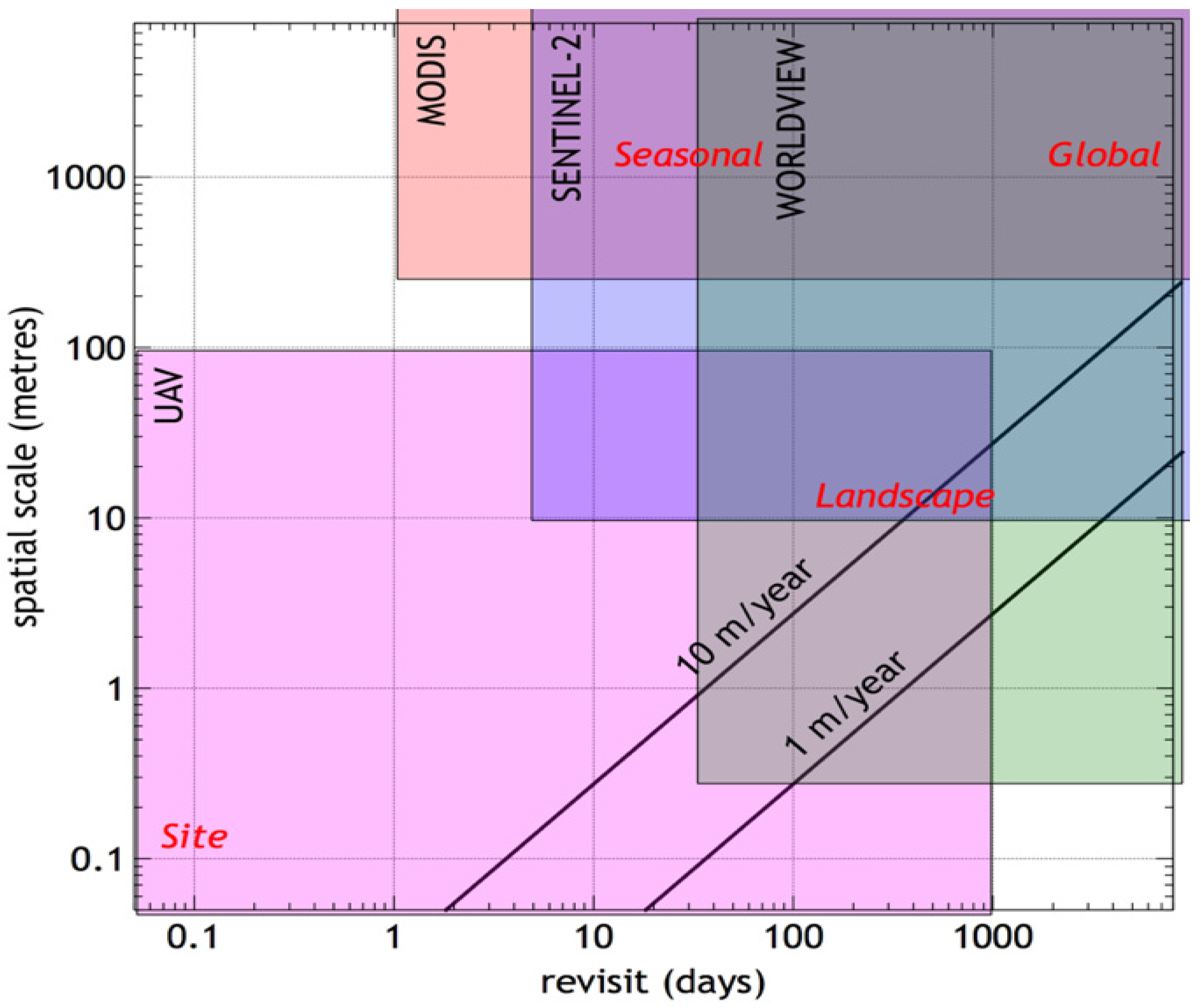
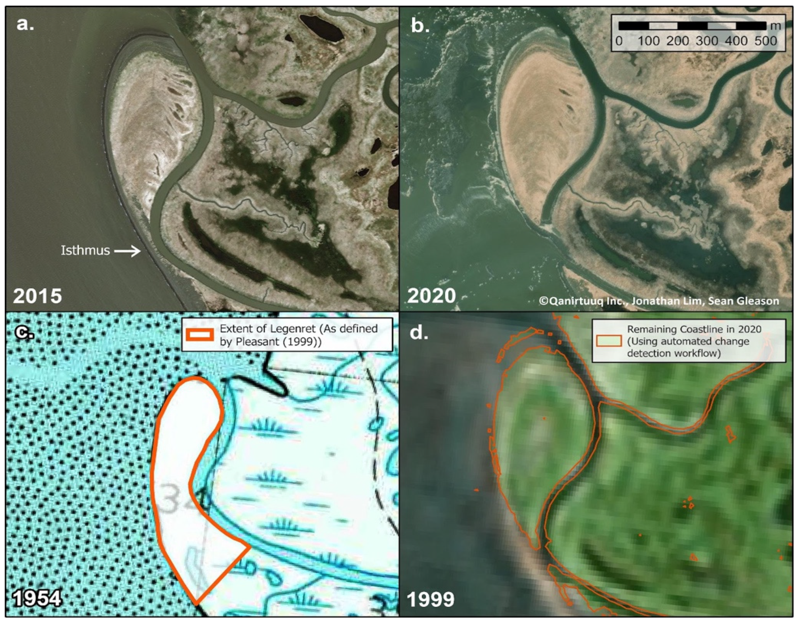
3. Remote Sensing
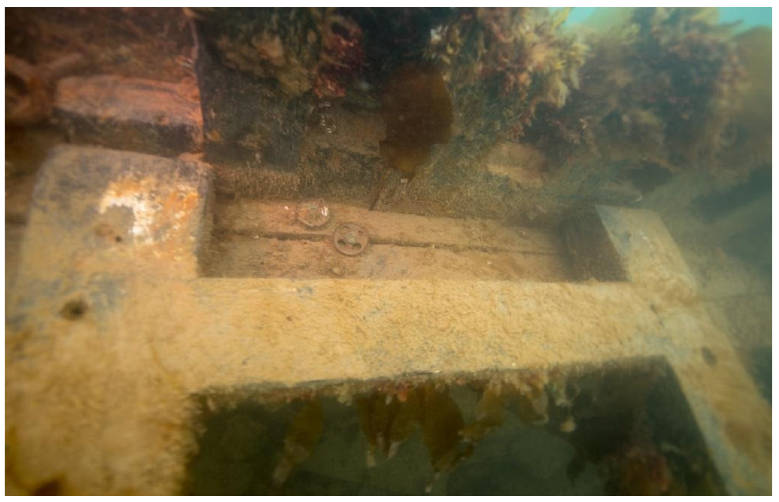
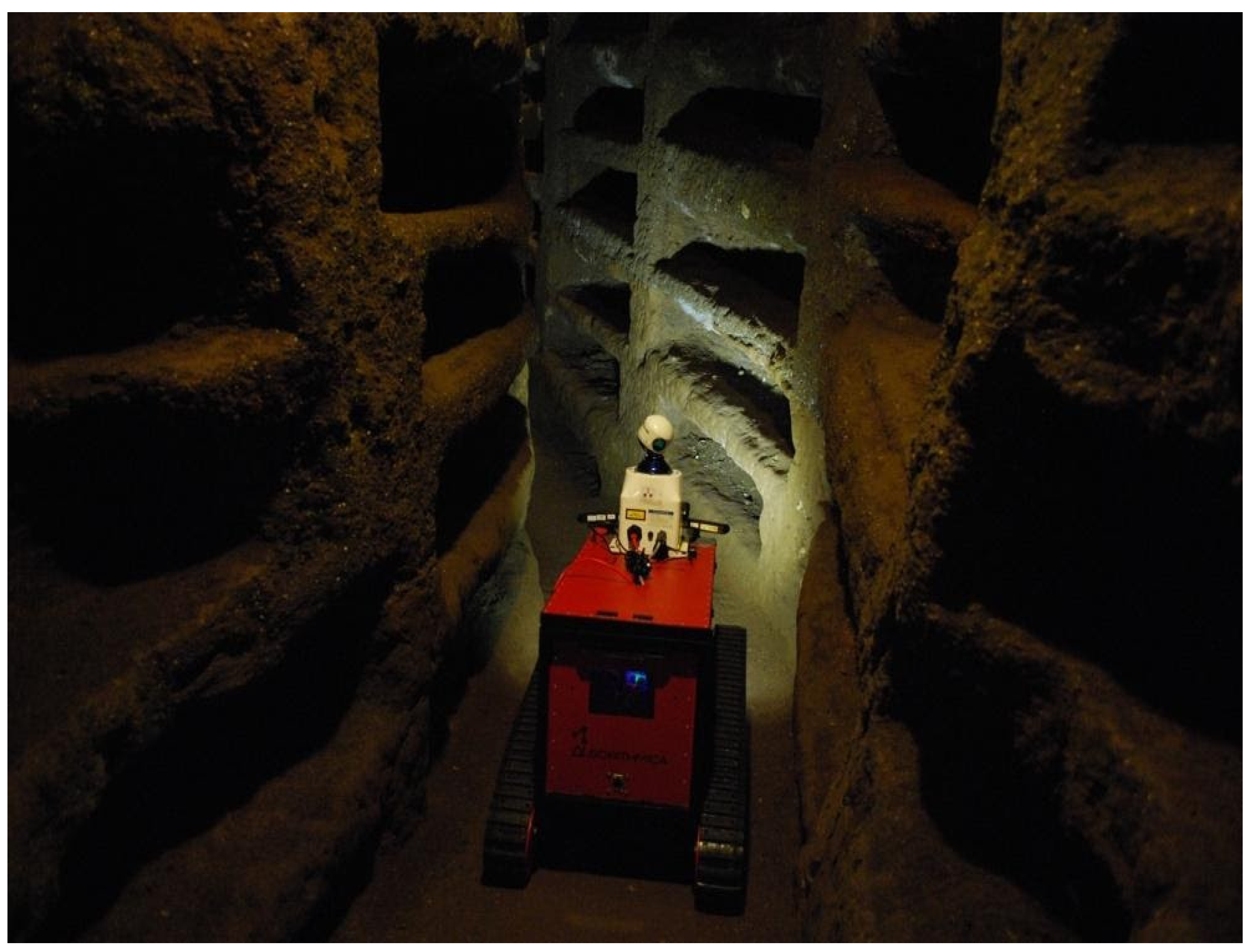
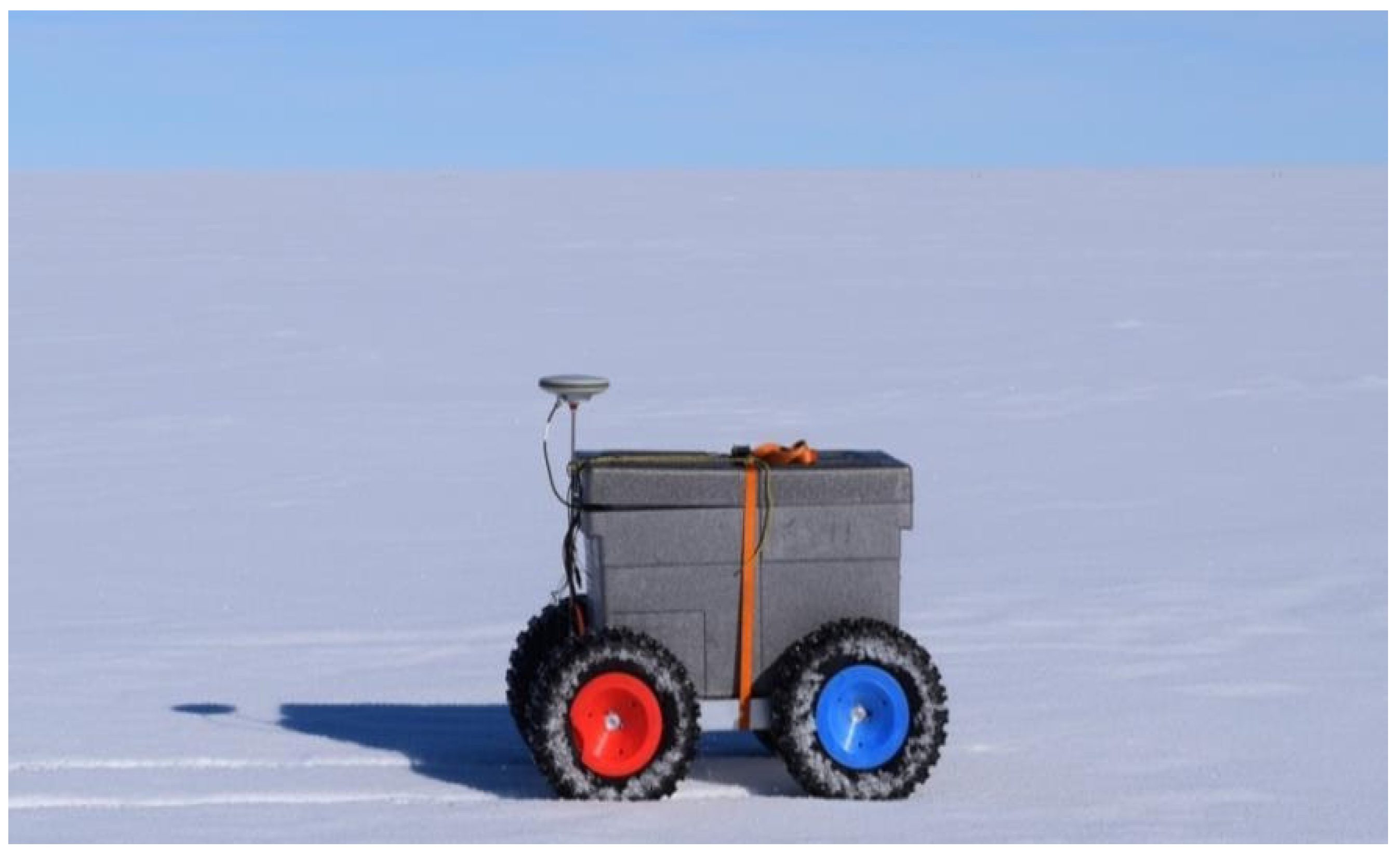
4. Robotics
5. Discussion
6. Conclusions
Author Contributions
Funding
Data Availability Statement
Acknowledgments
Conflicts of Interest
References
- ICOMOS Climate Change and Heritage Working Group. The Future of Our Pasts: Engaging Cultural Heritage in Climate Action. Outline of Climate Change and Cultural Heritage; ICOMOS: Paris, France, 2017. [Google Scholar]
- Hollesen, J.; Matthiesen, H.; Elberling, B. The Impact of Climate Change on an Archaeological Site in the Arctic. Archaeometry 2017, 59, 1175–1189. [Google Scholar] [CrossRef]
- Hollesen, J.; Callanan, M.; Dawson, T.; Fenger-Nielsen, R.; Friesen, T.M.; Jensen, A.M.; Markham, A.; Martens, V.V.; Pitulko, V.V.; Rockman, M. Climate Change and the Deteriorating Archaeological and Environmental Archives of the Arctic. Antiquity 2018, 92, 573–586. [Google Scholar] [CrossRef]
- Hollesen, J.; Matthiesen, H.; Fenger-Nielsen, R.; Abermann, J.; Westergaard-Nielsen, A.; Elberling, B. Predicting the Loss of Organic Archaeological Deposits at a Regional Scale in Greenland. Sci. Rep. 2019, 9, 9097. [Google Scholar] [CrossRef] [PubMed]
- Barr, S.; Pearson, M. Heritage at Risk in the Polar Regions. In Heritage at Risk: World Report 2016–2019 on Monuments and Sites in Danger; Machat, C., Ziesemer, J., Eds.; ICOMOS Deutschland: Berlin, Germany, 2020; ISBN 978-3-945880-67-8. [Google Scholar]
- Thepaut, J.; Pinty, B.; Dee, D.; Engelen, R. The Copernicus Programme and Its Climate Change Service. In Proceedings of the IGARSS 2018—2018 IEEE International Geoscience and Remote Sensing Symposium, Valencia, Spain, 22–27 July 2018; pp. 1591–1593. [Google Scholar]
- Metrikaityte, G.; Suziedelyte Visockiene, J.; Papsys, K. Digital Mapping of Land Cover Changes Using the Fusion of SAR and MSI Satellite Data. Land 2022, 11, 1023. [Google Scholar] [CrossRef]
- Amani, M.; Ghorbanian, A.; Ahmadi, S.A.; Kakooei, M.; Moghimi, A.; Mirmazloumi, S.M.; Moghaddam, S.H.A.; Mahdavi, S.; Ghahremanloo, M.; Parsian, S.; et al. Google Earth Engine Cloud Computing Platform for Remote Sensing Big Data Applications: A Comprehensive Review. IEEE J. Sel. Top. Appl. Earth Obs. Remote Sens. 2020, 13, 5326–5350. [Google Scholar] [CrossRef]
- Hillerdal, C.; Knecht, R.; Jones, W. Nunalleq: Archaeology, Climate Change, and Community Engagement in a Yup’ik Village. Arct. Anthropol. 2019, 56, 4. [Google Scholar] [CrossRef]
- Jensen, A.M. Culture and Change: Learning from the Past through Community Archaeology on the North Slope. Polar Geogr. 2012, 35, 211–227. [Google Scholar] [CrossRef]
- Friesen, M. Arctic Cultural Heritage at Risk Arctic (CHAR) Climate Change Impacts on the Inuvialuit 327 Archaeological Record; Inuvialuit Cultural Resource Centre, University of Toronto: Inuvik, NT, Cananda, 2017. [Google Scholar]
- Lim, J.; Gleason, S.; Jones, W.; Church, W. Nuna Nalluyuituq (The Land Remembers): Remembering Landscapes and Refining Methodologies through Community-Based Remote Sensing in the Yukon-Kuskokwim Delta, Southwest Alaska. Archaeol. Prospect. 2021, 28, 339–355. [Google Scholar] [CrossRef]
- Fiok, K.; Farahani, F.V.; Karwowski, W.; Ahram, T. Explainable Artificial Intelligence for Education and Training. J. Def. Model. Simul. 2022, 19, 133–144. [Google Scholar] [CrossRef]
- Parks Canada Agency, G. of C. Inuit Guardians Program. Available online: https://parks.canada.ca/lhn-nhs/nu/epaveswrecks/culture/inuit/gardiens-guardians (accessed on 9 November 2021).
- Solsten, B.; Aitken, A. An Application of GIS Techniques to Assess the Risk of Disturbance of Archaeological Sites by Mass Movement and Marine Flooding in Auyuittuq National Park Reserve, Nunavut. Géographie Phys. Quat. 2006, 60, 81–92. [Google Scholar] [CrossRef]
- Basilyan, A.; Anisimov, M.; Nikolskiy, P.; Pitulko, V. Wooly Mammoth Mass Accumulation next to the Paleolithic Yana RHS Site, Arctic Siberia: Its Geology, Age, and Relation to Past Human Activity. J. Archaeol. Sci. 2011, 38, 2461–2474. [Google Scholar] [CrossRef]
- Canadian Conservation Institute. The ABC Method: A Risk Management Approach to the Preservation of Cultural Heritage—Canada.Ca. Available online: https://www.canada.ca/en/conservation-institute/services/risk-management-heritage-collections/abc-method-risk-management-approach.html (accessed on 4 January 2023).
- Rees, G.; Brown, I.; Mikkola, K.; Virtanen, T.; Werkman, B. How Can the Dynamics of the Tundra-Taiga Boundary Be Remotely Monitored? Ambio 2002, Special Report 12, 56–62. [Google Scholar]
- Frederick, J.M.; Thomas, M.A.; Bull, D.L.; Jones, C.A.; Roberts, J.D. The Arctic Coastal Erosion Problem; US Department of Energy Office of Scientific and Technical Information: Oak Ridge, TN, USA, 2016. [Google Scholar]
- Philipp, M.; Dietz, A.; Ullmann, T.; Kuenzer, C. Automated Extraction of Annual Erosion Rates for Arctic Permafrost Coasts Using Sentinel-1, Deep Learning, and Change Vector Analysis. Remote Sens. 2022, 14, 3656. [Google Scholar] [CrossRef]
- Cunliffe, A.M.; Tanski, G.; Radosavljevic, B.; Palmer, W.F.; Sachs, T.; Lantuit, H.; Kerby, J.T.; Myers-Smith, I.H. Rapid Retreat of Permafrost Coastline Observed with Aerial Drone Photogrammetry. Cryosphere 2019, 13, 1513–1528. [Google Scholar] [CrossRef]
- Nicu, I.C.; Rubensdotter, L.; Stalsberg, K.; Nau, E. Coastal Erosion of Arctic Cultural Heritage in Danger: A Case Study from Svalbard, Norway. Water 2021, 13, 784. [Google Scholar] [CrossRef]
- Bogoyavlensky, V.; Bogoyavlensky, I.; Nikonov, R.; Kargina, T.; Chuvilin, E.; Bukhanov, B.; Umnikov, A. New Catastrophic Gas Blowout and Giant Crater on the Yamal Peninsula in 2020: Results of the Expedition and Data Processing. Geosciences 2021, 11, 71. [Google Scholar] [CrossRef]
- Lowe, D.G. Distinctive Image Features from Scale-Invariant Keypoints. Int. J. Comput. Vis. 2004, 60, 91–110. [Google Scholar] [CrossRef]
- Rauhala, A.; Tuomela, A.; Davids, C.; Rossi, P.M. UAV Remote Sensing Surveillance of a Mine Tailings Impoundment in Sub-Arctic Conditions. Remote Sens. 2017, 9, 1318. [Google Scholar] [CrossRef]
- Nicu, I.C.; Lombardo, L.; Rubensdotter, L. Preliminary Assessment of Thaw Slump Hazard to Arctic Cultural Heritage in Nordenskiöld Land, Svalbard. Landslides 2021, 18, 2935–2947. [Google Scholar] [CrossRef]
- Rees, W.G.; Golubeva, E.I.; Tutubalina, O.V.; Zimin, M.V.; Derkacheva, A.A. Relation between Leaf Area Index and NDVI for Subarctic Deciduous Vegetation. Int. J. Remote Sens. 2020, 41, 8573–8589. [Google Scholar] [CrossRef]
- Barlindhaug, S.; Holm-Olsen, I.M.; Tømmervik, H. Monitoring Archaeological Sites in a Changing Landscape–Using Multitemporal Satellite Remote Sensing as an ‘Early Warning’ Method for Detecting Regrowth Processes. Archaeol. Prospect. 2007, 14, 231–244. [Google Scholar] [CrossRef]
- Thuestad, A.E.; Tømmervik, H.; Solbø, S.A. Assessing the Impact of Human Activity on Cultural Heritage in Svalbard: A Remote Sensing Study of London. Polar J. 2015, 5, 428–445. [Google Scholar] [CrossRef]
- Poirier, D.; Feder, K. Dangerous Places: Health, Safety, and Archaeology; Bergin & Garvey: Westport, CT, USA, 2001; ISBN 0-89789-632-7. [Google Scholar]
- Taubenberger, J.K.; Hultin, J.V.; Morens, D.M. Discovery and Characterization of the 1918 Pandemic Influenza Virus in Historical Context. Antivir. Ther. 2007, 12, 581–591. [Google Scholar] [CrossRef] [PubMed]
- Roots, O.; Roose, A.; Eerme, K. Remote Sensing of Climate Change, Long-Term Monitoring of Air Pollution and Stone Material Corrosion in Estonia. Int. J. Remote Sens. 2011, 32, 9691–9705. [Google Scholar] [CrossRef]
- Rees, W.G.; Rigina, O. Methodologies for Remote Sensing of the Environmental Impacts of Industrial Activity in the Arctic and Sub-Arctic. In Social and Environmental Impacts in the North; Kluwer: Dordrecht, The Netherlands, 2003; pp. 67–88. [Google Scholar]
- Bondur, V.G.; Vorobev, V.E. Satellite Monitoring of Impact Arctic Regions. Izv. Atmos. Ocean. Phys. 2015, 51, 949–968. [Google Scholar] [CrossRef]
- Hoffman, A.; Steen-Larsen, H.; Christianson, K.; Hvidberg, C. A Low-Cost Autonomous Rover for Polar Science. Geosci. Instrum. Methods Data Syst. 2019, 8, 149–159. [Google Scholar] [CrossRef]
- Cocksedge, A. The Use of Compact Surveillance Radar to Study Polar Bears (Ursus Maritimus) 315 near Churchill, Manitoba, Canada. Master’s Thesis, University of Toronto, Toronto, ON, Canada, 2020. [Google Scholar]
- Aguzzi, J.; Albiez, J.; Flögel, S.; Godø, O.R.; Grimsbø, E.; Marini, S.; Pfannkuche, O.; Rodriguez, E.; Thomsen, L.; Torkelsen, T.; et al. A Flexible Autonomous Robotic Observatory Infrastructure for Bentho-Pelagic Monitoring. Sensors 2020, 20, 1614. [Google Scholar] [CrossRef]


Disclaimer/Publisher’s Note: The statements, opinions and data contained in all publications are solely those of the individual author(s) and contributor(s) and not of MDPI and/or the editor(s). MDPI and/or the editor(s) disclaim responsibility for any injury to people or property resulting from any ideas, methods, instructions or products referred to in the content. |
© 2023 by the authors. Licensee MDPI, Basel, Switzerland. This article is an open access article distributed under the terms and conditions of the Creative Commons Attribution (CC BY) license (https://creativecommons.org/licenses/by/4.0/).
Share and Cite
Lintott, B.; Rees, G. Arctic Heritage at Risk: Insights into How Remote Sensing, Robotics and Simulation Can Improve Risk Analysis and Enhance Safety. Remote Sens. 2023, 15, 675. https://doi.org/10.3390/rs15030675
Lintott B, Rees G. Arctic Heritage at Risk: Insights into How Remote Sensing, Robotics and Simulation Can Improve Risk Analysis and Enhance Safety. Remote Sensing. 2023; 15(3):675. https://doi.org/10.3390/rs15030675
Chicago/Turabian StyleLintott, Bryan, and Gareth Rees. 2023. "Arctic Heritage at Risk: Insights into How Remote Sensing, Robotics and Simulation Can Improve Risk Analysis and Enhance Safety" Remote Sensing 15, no. 3: 675. https://doi.org/10.3390/rs15030675
APA StyleLintott, B., & Rees, G. (2023). Arctic Heritage at Risk: Insights into How Remote Sensing, Robotics and Simulation Can Improve Risk Analysis and Enhance Safety. Remote Sensing, 15(3), 675. https://doi.org/10.3390/rs15030675