Article

The Use of Common Knowledge in Fuzzy Logic Approach for Vineyard Site Selection

1
Department of Urban Design & Planning and Settlement Processes, Wrocław University of Science and Technology, 50-317 Wrocław, Poland
2
Institute of Environmental Protection and Development, Wrocław University of Environmental and Life Sciences, 50-363 Wrocław, Poland
3
Institute of Spatial Management, Wrocław University of Environmental and Life Sciences, 50-357 Wrocław, Poland
*
Author to whom correspondence should be addressed.
Remote Sens. 2020, 12(11), 1775; https://doi.org/10.3390/rs12111775
Submission received: 30 March 2020 / Revised: 1 May 2020 / Accepted: 29 May 2020 / Published: 1 June 2020

Abstract

:
A multitude of factors considered necessary for an informed choice of the location of the vineyard can be overwhelming for the decision-maker. Is there still a place for knowledge valuable from the perspective of an experienced winegrower in the era of precise measurements? The informative use of so-called common knowledge is possible owing to fuzzy-based techniques, which allow for the representation of intuitive notions in terms of quantitative measures. The work uses tools based on fuzzy logic to cover the scope of common knowledge within the decision-making process. Owing to its flexibility and ability to deal with imprecise input data while maintaining the simple construction, the fuzzy logic solution filled the gap between GIS data and wine grower’s experience. Based on the data from the thematic literature, a set of rules was created to interpret the relationships between popular site selection criteria. The dynamics and manner of interaction between variables were determined using adequate membership functions. Pre-processing using GIS with remote sensing data was considered as a preliminary stage for the analysis. By using the graphical interface, the system operation facilitates the work of a potential user. The obtained results indicated the possibility of an alternative approach to classical analyses by replacing or extending the meaning of some variables using information based on feelings and perceptions. Research constitutes a premise for the further development of expert systems using widely understood domain knowledge.

Graphical Abstract

1. Introduction

The wine industry is an emerging economic sector in many parts of the world like Asia [1], Africa [2], America [3], Australia [4], and Europe [5]. The development of wine production requires the transformation of selected croplands into vineyards. Within this process, site selection is proved to be the most significant and fundamental decision in the whole life of a vineyard [6,7,8]. Researchers and winemakers underline that there is no other comestible product that reflects its place of origin as it is in the case of the vine [9]. This specification of a particular space is named a “terroir”. It is defined as an interaction between the physical and human environment [10]. The primary physical environment attributes that are usually considered are climate, soils, and topography, while the human environment most frequently refers to viticultural practices and legal constraints [7,10,11]. The criteria on which the process of site selection is based are defined as “factors” in the professional wine industry related literature. The set of factors in particular “terroir” reveals originality and recognition of the products [9], and the combination of site and grape variety affects the future results each season [7]. Therefore, a recognition of factors and inter-relationships between them that influence the vineyard prospering has the crucial role in the site selection. Nevertheless, the process of choosing factors and analyzing them is complicated. First, there is an ongoing debate on which of the factors is the most significant [10]. According to Wilson [12], science may not understand factors in a range that will allow to define the contribution of them. Moreover, the contribution of specific factors varies across the land and is different for specific regions [13,14]. Additionally, Wilson underlines other aspects of “terroir” connected with somewhat spiritual and not measurable factors such as “the joys, the heartbreaks, the pride, the sweat, and the frustrations of history” [12] (p. 55), which for many people are more important while selecting the site than the scientific reasons. Although, while the general factors are instead stated, the analyses that contribute to each of them differentiate widely.
Through years researchers have verified attributes of terroir based on relationships between vineyard site and quality of wine [10]. Based on all the factors ever mentioned by researchers and winegrowers, the analyses can be very extensive. Every factor is related to data that should be acquired, which is also connected with the costs of the entire site selection process. While the quality information is essential—the cost rises when the precision of data increases [7]. It is especially crucial at the first stage of site selection when there are many site options, and the risk of acquiring data that is not required is high.
Additionally, even if every factor will be examined by an expert and the data will be of the highest possible quality—the perfect terroir may not be found, while the site selection is usually based on compromises [10]. Apart from these reasons, the question of sustainability arises. It is crucial to remember that vineyard is a part of a broader ecosystem, and this aspect should also be considered while selecting the site [8].
When the data strategy is already chosen, there is also a question about a method of analysis that should include an optimal amount of factors and correlation between them to achieve the best results while minimalizing the costs and risks. Experts nowadays are most often recommending the utilization of geospatial and remote sensing technologies to support decisions in the vineyard selection process [7,8,10,15,16,17]. The multi-criteria analyses in geographic information systems (GIS) enable the incorporation of factors related to spatial data such as climate, topography, soils, and land-use [10,18,19,20,21]. Criteria connected with these factors could be presented as geographic layers and then aggregated and assessed with GIS tools, including their reclassification, assessment of different weights, and applying priorities to different criteria [7]. The necessary data that has to be gathered to perform analyses include climate and soil maps, remote sensing data (LIDAR data and vector data (for point, linear and polygonal features such as buildings, rivers, water sources)), and land-zone maps. Difficulty and cost of the information gathering vary across the land—while in some regions, maps can be outdated or even non-existent. However, not always the quality and availability of data allows for practical spatial analysis, researchers agree on the need to use GIS tools or remote sensing at the initial stage of selecting “candidate” locations [22,23]. Following these examples, the workflows emerged within the field, which successfully combine remote sensing science with applied fuzzy logic functionality [24,25,26,27]. This first selection stage is crucial because it largely depends on the success of the methods to expand the final decision space. Besides, because of its flexibility, preliminary spatial analyses can be supplemented as data availability increases along with the popularity of remote sensing science, gradually increasing its participation in the decision-making process without harming, e.g., alternative sources of information [28,29].
Struggles in data acquisition can significantly extend the process of vineyard site selection and the costs related to it with the necessity to hire experts from the field of biology, chemistry, or climate. Some criteria are not representable in spatial dimension and can be defined as “common knowledge.” Some winegrowers are convinced that while technology and experts could improve the quality, the vineyard site selection requires the utilization of local wisdom, knowledge, intuition and walking over the site to “sight, touch, smell and in some cases even taste to determine its viticultural potential” [14] (p. 60).
In the case of criteria based on feelings, experiences, as well as knowledge not resulting directly from the analysis of numerical data, making decisions can cause many problems, often leading to the abandonment of these criteria or their significant reduction [28]. However, research confirms that the use of this type of information in the decision-making process can have positive effects on the result [28,30,31]. Methods based on multi-criteria decision-making systems were used to include qualitative factors in the decision-making process [32] (p. 299–300). In recent years, the popularity of these methods has increased, which confirms their increasing use in fields such as environmental engineering [33], business [34,35], spatial planning [36,37,38,39], and social science [40]. One of the theories used in decision systems is the logic of fuzzy sets [41]. Part of this theory is the so-called fuzzy logic, which allows the occurrence of several intermediate values determining the degree of belonging of a given element to the set [42]. This logic proved to be useful in engineering applications [43,44], data mining [45], but also the construction of so-called expert systems [46,47]. Owing to the ability of fuzzy logic systems to generalize knowledge not previously interpreted as a part of classical logic, it became possible to construct “intelligent” systems that could start using unconventional knowledge [48]. These systems have also been successfully introduced in studies using spatial information—improving the process of making location decisions [31,49,50,51]. The most important spatial information for the location of vineyards using fuzzy logic was included by Badr [31], while Coulon-Leroy pointed to the possibility of using imperfect knowledge in the modeling of sophisticated agronomic features [52]. The research was also carried out on the use of local knowledge in situating vineyards [53,54].
Finally, while facing all factors, problems, and constraints mentioned above, there is always a decision of winegrower on what strategy of analyses to choose. That is why a method used for vineyard selection should be flexible and adjusted to local conditions and legal constraints, costs, and risks that the winegrower is ready to sustain and also one’s beliefs that may refer to common knowledge. In this paper, the method that enables the inclusion of common knowledge in vineyard site selection is presented. The system based on fuzzy logic was built as an extension of preliminary spatial analysis and was used in an attempt to transfer factors considered to be qualitative, as well as those that do not require technical support into a framework that allows obtaining informative data. During the creation of the system, the focus was placed on the factors constituting an alternative to widely used methods based on costly, expert-involved research, while maintaining the fundamental GIS-based pre-processing. The primary purpose of this work is, therefore, an attempt to enhance spatial decision-making technologies with the use of collective knowledge factors when assessing the suitability of a given site for wine-growing.
This paper is organized as follows. In the second section—Materials and Methods—the data used to obtain general knowledge information is introduced as well as the outline of preliminary spatial analysis, followed by a basic description of the fuzzy logic-based methodology used in this paper. In the Results section, the proposition of the knowledge acquisition method is presented, and then, by specifying membership functions and rules, system operation is proposed. The Discussion section presents the conclusions of the decision-making environment, along with parallel applications. The possibilities of further research on the use of common knowledge in the vineyard site selection are also discussed.

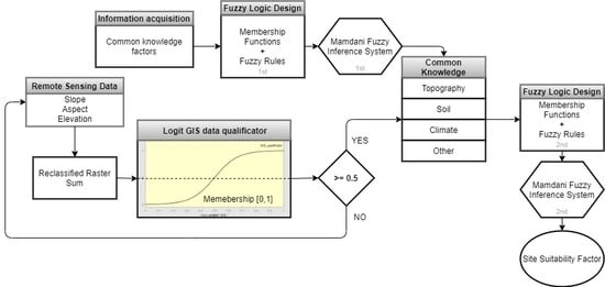
2. Materials and Methods

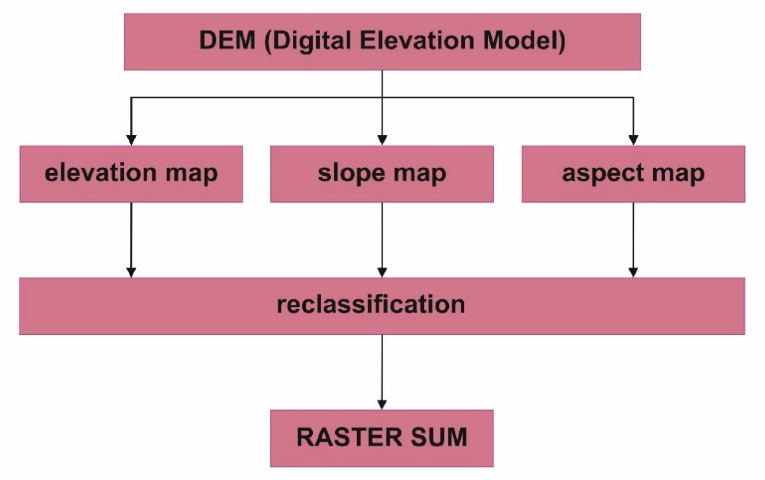
2.1. Materials for Spatial Information Acquisition

Among factors that can be considered while selecting the site for vineyard, a significant number of them requires expert analyses and utilization of specific techniques (including GIS tools). When choosing the initial criteria for determining the location conditions, it is vital to trace the standards for different regions of the world [55]. An essential factor for the entire analysis is access to remote sensing data with a resolution that allows to obtain minimal informative knowledge, which constitutes the basis for the use of extensions based on the fuzzy logic system. It should be noted at the same time that the quality and availability of numerical altitude data is continuously increasing and is available without charge in many areas [56]. Three fundamental analyses that are necessary for valid pre-location selection include determining elevation, slope, and aspect suitability (Figure 1).

2.2. Materials for Common Knowledge Acquisition

The information, obtained at an initial stage, can be successively expanded by a number of additional remote or on-site tests. Although remaining additional factors can be examined with alternative effort or lower cost with the utilization of information type that can be addressed as common knowledge. These factors are defined in this paper as “interchangeable,” while they can be examined by an expert but also by a winemaker her-/himself based on observation and site inspection. Some factors, such as, i.e., slope, aspect, are not replaceable with common knowledge and could be defined as “expert only”. However, there is also a group of factors that refers exclusively to local knowledge and could be defined as “the common only”, such as local winegrower examination or history of viticulture of the site. Table 1 presents the groups of chosen interchangeable factors and the common only factors with the common knowledge descriptions that were the basis for the method of vineyard site selection explained below.

2.3. Information Acquisition and Membership Functions

The information contained in the revised scientific literature (Table 1) has been developed based on input data to apply the basic principles of the fuzzy logic decision framework. According to the method used, the input variables were considered in two stages. First, the sub-models in each of the thematic groups were created, and then, aggregated results for each group were subjected to the final application. Below is the method of formulating input data ranges (Table 2) and identification queries for the first stage of the analysis. In order to make the assessment process easier for users, the ranges of notes for particular criteria were fitted into a fixed 0 to 10 scale, except for the “internal water drainage” factor, where authors suggest 0 to 60 range pointing to the “intuitive” understanding of information presented in hours. In case of “pH level” variable—the 0–10 range results from default pH scale and does not result from any transformations. Also, the y-axis representing set of membership function values was normalized to 0–1 range for further aggregation and presentation convenience.
Support inquiries have been prepared to enable the user to work with the decision-making system. The supporting queries were developed in order to provide help for user during adjustment to 1 to 10 operating scale. For instance, while assessing the particular variable, there should be a question as: “In scale from 0 to 10—what is the measure of sensation, according to the evening walk test, given that 0 means no chill perceptible and 10 stands for distinct cooling sensation?” Each of the variables can be assessed on a given range by responding to an issue as directed (Table 3). If the question does not apply to a specific site, it is possible to select the “none” option, which will exclude the indicator from further analysis. For a detailed description of parameters to which the queries refer—please see Table 1 (Materials and Methods section) with supporting references.
The examples of graphical representations of the developed membership functions, are presented below (Figure 2, Figure 3 and Figure 4). The complete set of functions, broken down into groups of variables, is presented in Appendix A. The choice of functions was based primarily on the analysis of information contained in the text so that it was possible to reflect the underlying dynamics of variability and the nature of the guidelines. During the analysis of the text describing the considerations of common knowledge, the courses of functions were adapted to the description. For instance, the intensity of erosion was applied by means of two triangular functions, because of the unambiguous indication of stress conditions (description of moderate and excessive erosion), the lacking obvious middle point criterion in the text caused the intersection of functions at an understandable point (5,0.5) (Figure 2). The membership function for pH level was developed based on accurate operational scale for this factor. Starting from “too-low” at the beginning of the scale, generalized bel-shaped decreases gradually and gains increase positive membership value from 4.6 to 6 (optimal pH), maintained through 6 to 7 (acceptable pH), and afterwards intersected by “too_high” function at 0.3 membership value of 7.3 pH, gradually increasing to 1, which points to the—better documented in literature—negative impact of too high soil pH level, than this considered as too low (Figure 3). In case of viticulture history factor, the chosen gaussian functions are constructed in a way, that with the existence of strong deceptive proof or information bias denoted in the literature, the membership value is at its peak (1) for negative assessment. As the belief in deceptiveness of data decreases, and no proof for proper positive history is given, the functions reach intersection in point (5,0.2) which indicates no extensive harm to the decision-making process as the knowledge is neutral (or there are no convincing proofs for either scenario). As the belief in data that confirm positive scenario increases, the function gradually increases from 5 to 10, which points to proven 70–80 years of farming practice (Figure 4).
Logical rules have been created for each set of variables within individual groups. Employing rules, it was possible to compile the results of the evaluation of variables within the fuzzy inference system. The general logical framework used for operations on functions within one variable is presented in Table 4. Thus, it was possible for knowledge obtained from literature to be reflected in fuzzy rules.
Mamdani fuzzy inference was first implemented as a method of constructing a control system through the synthesis of a set of language control rules obtained from experienced human operators [65]. Since Mamdani systems have more straightforward and easy to comprehend rule bases, they are better adapted for expert system implementations where the rules are generated from actual expert experience, such as medical diagnostics. In this research, the Mamdani was chosen based on its applicability to common knowledge interpretation skill and on its advantages confirmed in literature: intuitive, well-suited to human input, interpretable rule base, and widespread acceptance [66]. The output of each rule is a Fuzzy set derived from the function of the output membership and the FIS inference process. Using the FIS aggregation method these output fuzzy sets are combined into one single fuzzy set. The combined output fuzzy collection is then defuzzified to determine a final crisp output value using one of the methods defined as defuzzification methods.
Fuzzy rules developed for topography, soil, climate, and other variables are presented in Appendix B.

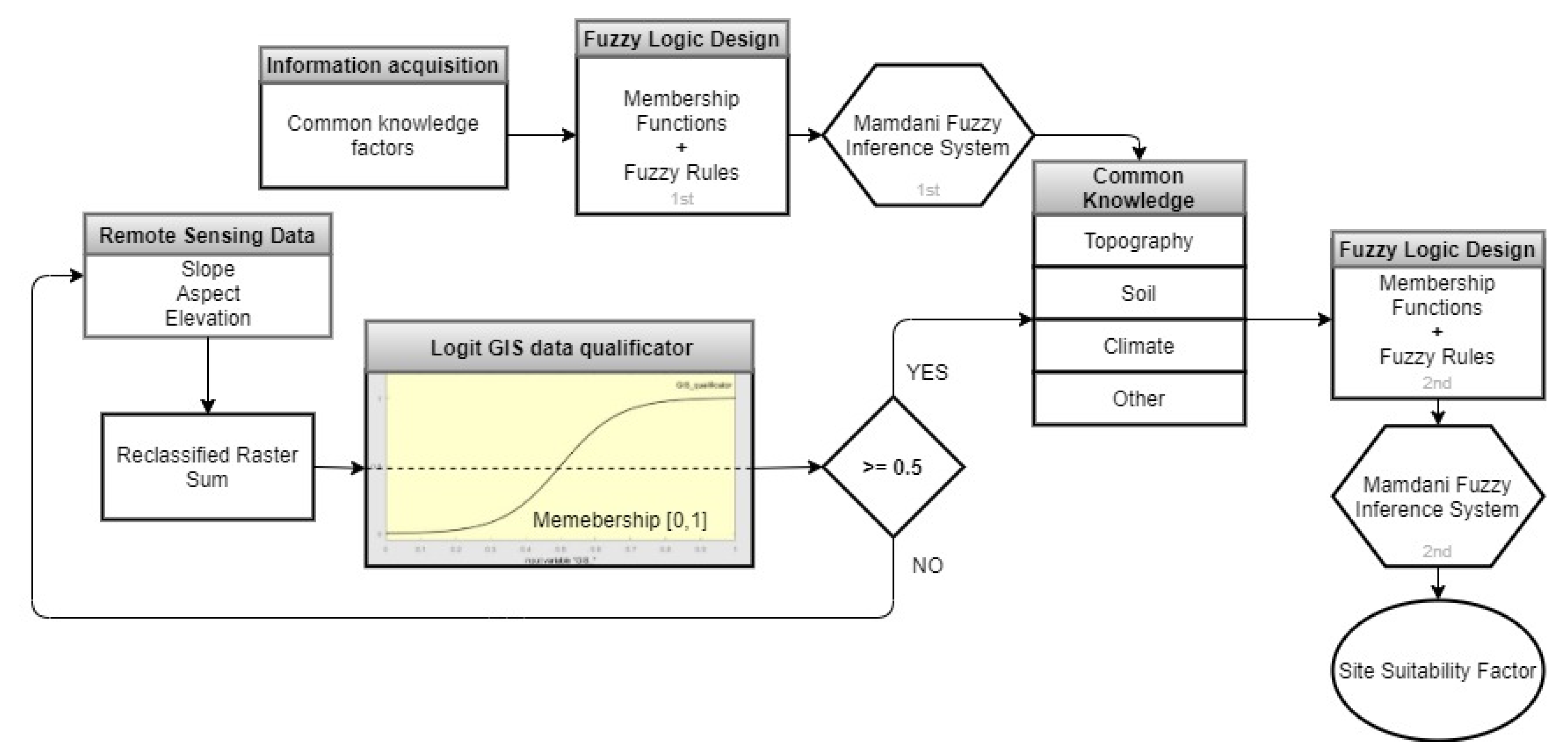
2.4. Implementation of Fuzzy Logic-Based System

Figure 5 shows the basic idea of a fuzzy system used in this research. Its components are as follows [67]:
  • Factors—fundamental data, which consists of common knowledge obtained from the literature search. As the aim of this paper states: only the Common and Interchangeable variables were used in further steps;
  • Information acquisition—it is the phase of translating acquired data into manageable information in terms of deriving if-then rules, as well as ranges of possibilities;
  • Membership functions—a step of applying proper membership functions to different linguistic terms;
  • Fuzzy rules—a transformation of acquired information to a set of if-then rules with selected examples of principles used in the process of aggregating results from individual groups:
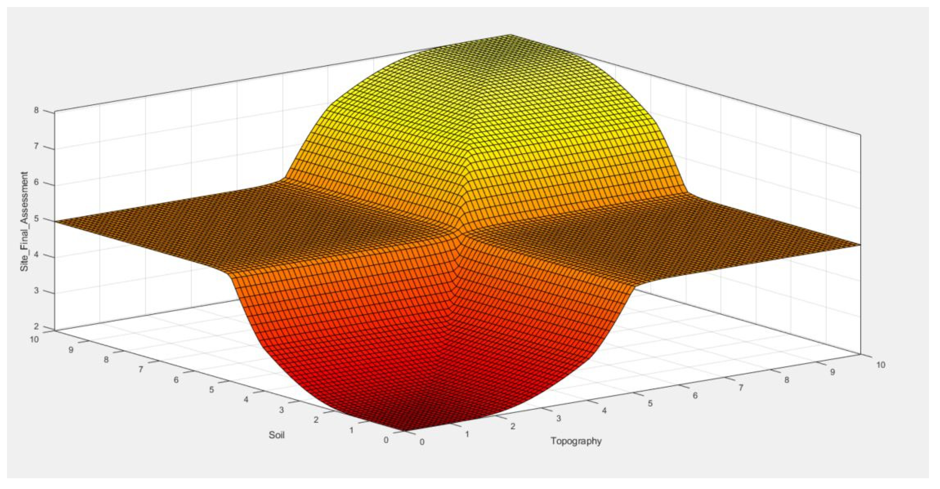
    • (Topography==Bad) & (Soil==Bad) & (Climate==Bad) & (Other==Bad) => (Site_Final_Assessment=Bad_Site) (1)
    • (Topography==Good) & (Soil==Bad) & (Climate==Good) & (Other==Good) => (Site_Final_Assessment=Average_Site) (1)
    • (Topography==Good) & (Soil==Good) & (Climate==Good) & (Other==Bad) => (Site_Final_Assessment=Average_Site) (1)
    • (Topography==Good) & (Soil==Good) & (Climate==Good) & (Other==Good) => (Site_Final_Assessment=Good_Site) (1)
    • (Topography==Bad) & (Soil==Good) & (Climate==Good) & (Other==Bad) => (Site_Final_Assessment=Bad_Site) (1)
  • Fuzzy inference system—a process of the inference cycle fuzzy matching execution, fuzzy conflict resolution (logical operators strategy), and fuzzy rule-firing when faced with given information;
  • User interface—environment for communication between fuzzy decision support system and user. The interface should be as easy to follow as possible.
While interpreting the acquired if-then rules, the following steps were performed [68]:
  • Fuzzification of input: resolving of all fuzzy statements in the antecedent to a degree of membership between 0 and 1.
  • Application of fuzzy operator to multiple part antecedents: applying fuzzy logic operators to resolve the antecedent to a single number between 0 and 1, which is the degree of support for the rule.
  • Application of implication method: using the degree of support for the entire rule to shape the output fuzzy set. The consequence of a fuzzy rule assigns an entire fuzzy set to the output. This fuzzy set is represented by a membership attribute, which is chosen to show the following qualities. If the antecedent was only partially valid (i.e., a value less than one is assigned), then the inference method truncated the output fuzzy set under the chosen implication method (Appendix C).
For this research, the MATLAB® Fuzzy Logic Designer by MathWorks® was used [67].

3. Results

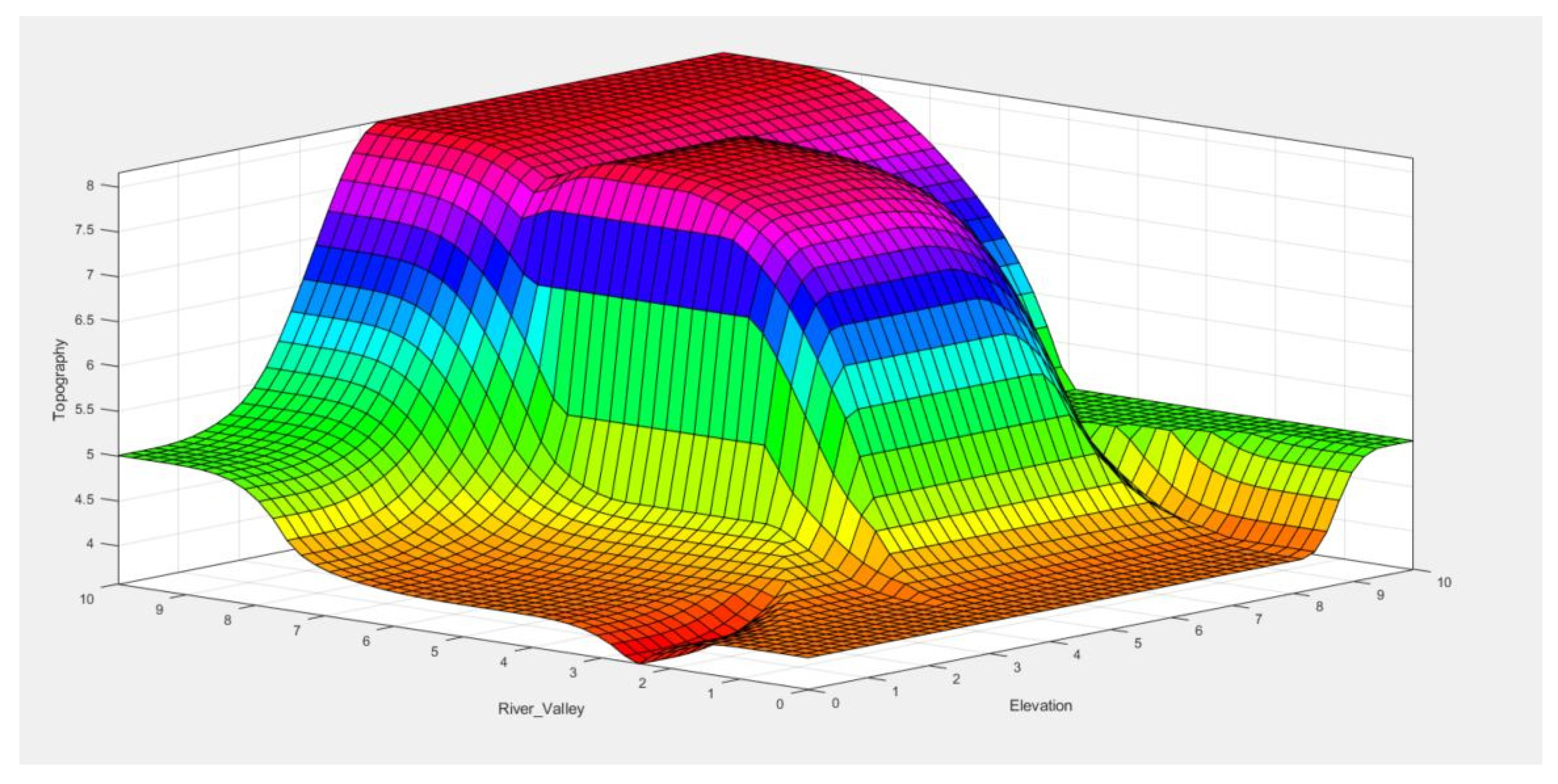
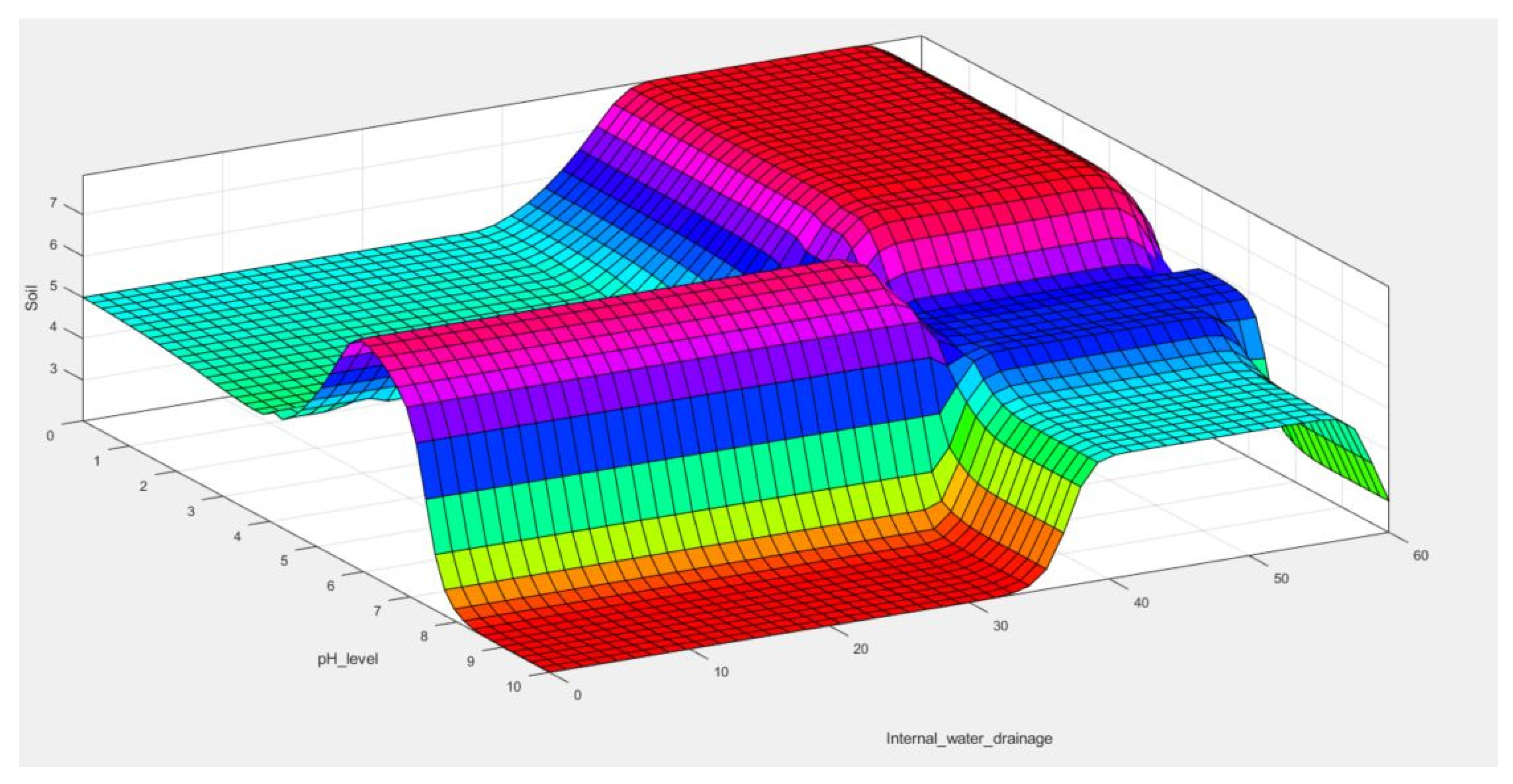
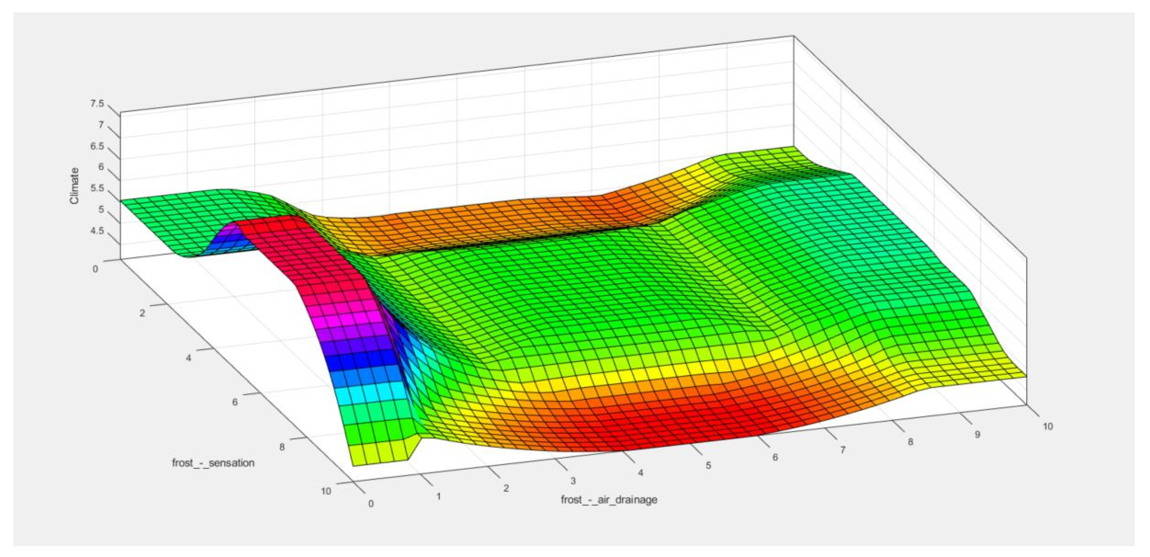
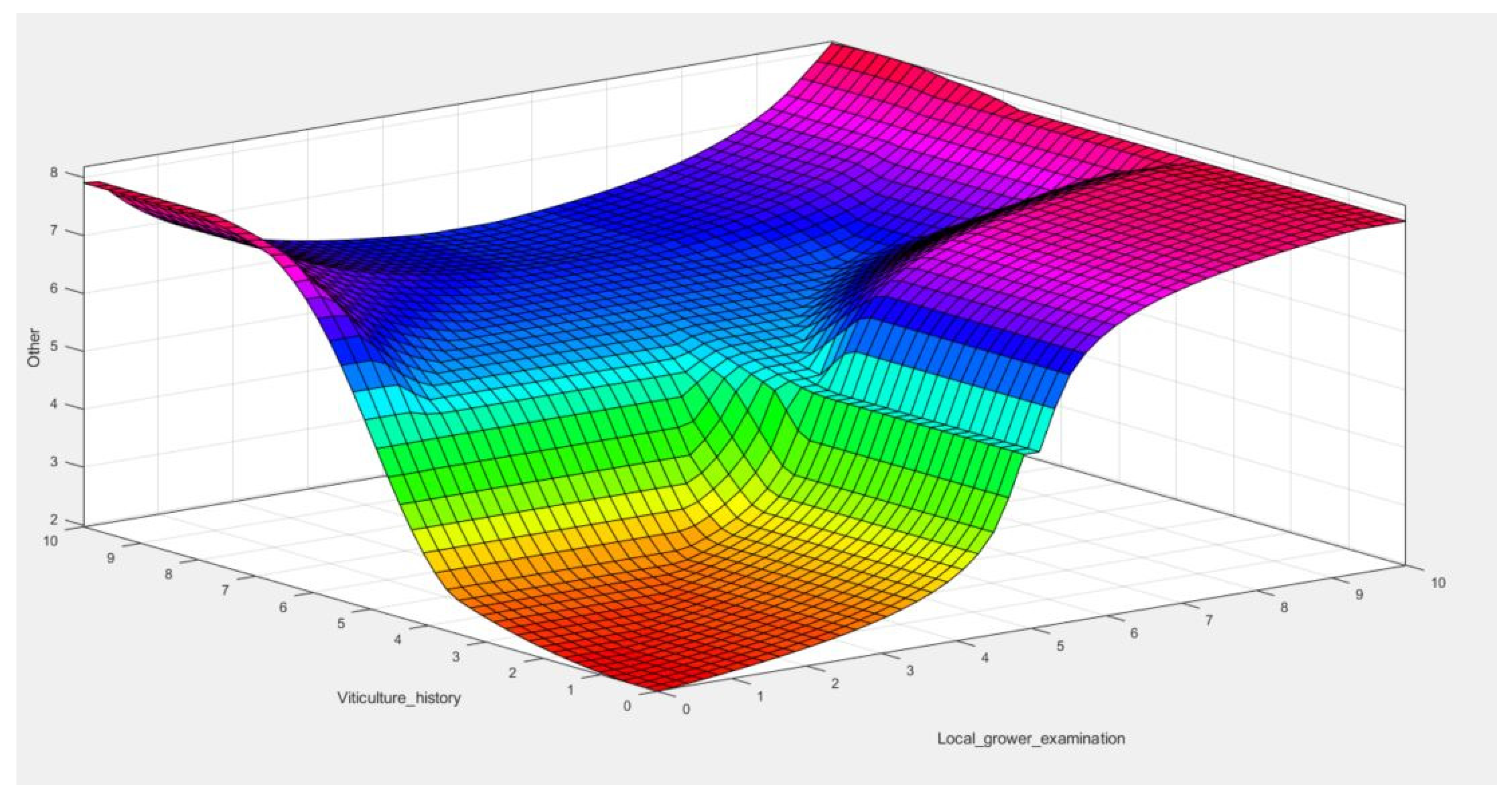
3.1. Graphical Representation of the Developed Fuzzy System

Examples of relationships between variables in their possible configurations are presented in the following part of the paper. This representation of the rules allows a better understanding of the often complex logical relationships between a large number of variables in their various states. One example per category is presented (Figure 6, Figure 7, Figure 8 and Figure 9). The impact of particular notes given to two of the variables is then interpreted with logical rules and finally is visible as a position on the surface graph. It is possible to observe a sample space for each possible outcome. The color HSV (hue, saturation, value) scale on the graph represents the similar regions of the variable set logical intersection resulting in adequate output on Z-axis. It is possible to observe what is the impact on topography suitability assessment when assigning different notes to River Valley and Elevation factors. For instance, in order to achieve high topography rating in the decision system, the notes of values should fall between 3.5 and 10 for Elevation and 7.5 to 10 in case of River Valley component.

3.2. Aggregated Results

The results obtained from the created sub-models were again included in the membership gunctions framework so that it was possible to aggregate the results of groups and present the results within a unified space. As in the previous stage of work, a set of rules was created to implement aggregation using Mamdani FIS (Figure 5). The graphic representation of the event space (set of all possible outcomes or results of experiment driven by developed rules) for sample variables: topography and soil shows how the decision system has been simplified compared to analyses within sub-models (Figure 10). It is noticeable that to achieve a high suitability note, the topography and soil categories should both gain values above 5 in the decision-making process, reaching the peak at 8. It is worth noticing, that the resulting value of 10 is impossible in that case, because there is a lack of remaining components (climate and other), so the model is penalized. This is due to the use of previously systematized results, which allowed for derivation of fewer, clear rules. The appearance of the event is also affected by the use of equal weights for individual variables.
After the preparation and aggregation of data within sub-models, followed by the final model, it is possible to support the decision-making process using user interface (Figure 11). Similar interfaces have been already used at the stage of working on sub-models to help assess individual variables within each group. The results of these assessments, after transformation into membership functions, allowed for intuitive control of the process of assessing the potential of a given location (on a scale from 0 to 10) to establish a vineyard.

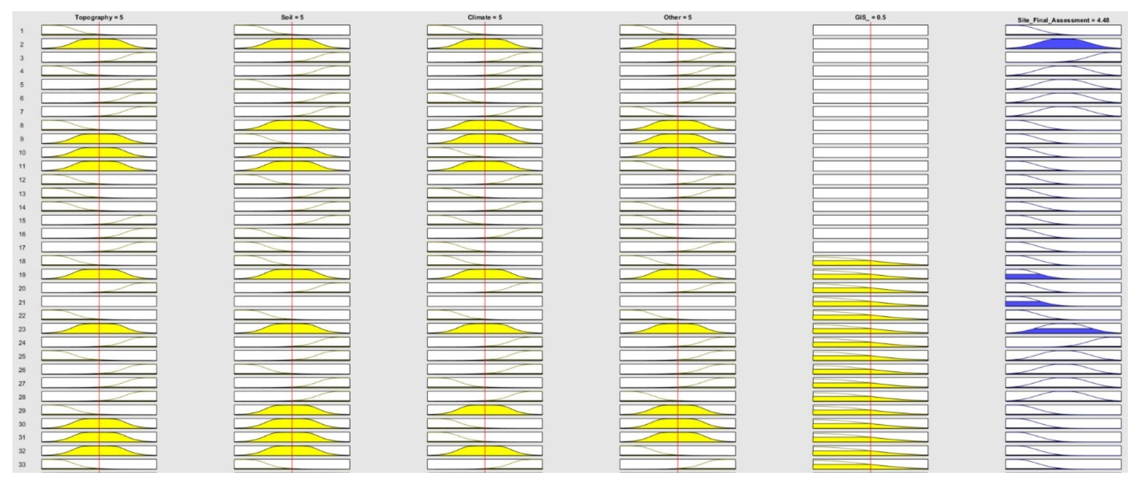
3.3. Assessment Method Simulation

There was a simulation of vineyard site assessment methodology performed. A set of notes was selected to present how different notes impact the “site final assessment factor.” The example was done for factors aggregated within sub-models. According to the implemented method, the GIS reclassified factor acts as a logit qualificator for further computations. Table 5 contains results of ten different assessment scenarios.
The different tested scenarios of factors arrangement for suitability assessment show how set of developed rules interact with membership functions to obtain final result.

4. Discussion

The research undertaken in this work focused on checking the possibilities of decision-making with the use of expert and common knowledge factors when assessing the suitability of a given site for wine-growing. In practice, the systematization of common knowledge issues is intended to help expand the decision-making space when particular “hard” data is unavailable, impossible to use for various reasons. This situation may occur when making location decisions for vineyards that require access to a large amount of various data, often of qualitative nature with non-technical origin. In the paper, the implementation possibility of fuzzy inference acting as a valuable supplement to the basic GIS and remote sensing methods was proposed. Referring to others [31,69,70] pointing to active cooperation and flexibility of these environments, which allows maintaining balance in the selection of methods, depending on the user’s capabilities. It is also suggested that methods based on fuzzy logic could be useful for winegrowers who want to systematically use a large amount of information and then attempt to support or question the decisions suggested by other sources of information. The method can also be a way to collect knowledge and observations that winegrowers have been passing on for generations, or that have been operating in the environment for a long time as so-called “rules of thumb”.
In thematic literature, it is confirmed that common knowledge is an essential and potentially applicable element, especially in an industry as old and rich in “proven rules” as winemaking [55,71]. In this case, it also seems reasonable to strive to incorporate unconventional or non-scientific knowledge into the decision-making process [14,72]. This need is associated with the traditional approach that is continuously present in the environment, referring to “sight, touch, smell, and (…) taste” example from Introduction [73]. Similarly, as pointed out by [14], a properly developed system of this type can achieve the status of “expert system” over time—especially given the possibility of its continuous expansion. This is a direction that has already been taken by specialists from other industries [74,75]. The most important aspects of the advantage of well-developed expert systems over the traditional approach to mathematical modeling have been demonstrated in the literature [76]. However, the near future does not indicate that fuzzy logic-based systems will obtain the status of unambiguous and underlying sources of informative decisions. This is due to the existing limitations of these solutions.
Fuzzy controllers and inference systems used for this research require predefined membership functions and fuzzy inference rules for mapping data into linguistic variable terms to make fuzzy work [77]. With unique domain knowledge as context, the decision-making function was to use an inference technique to get an optimal or nearly optimal solution from input information. In numerous research, various methods concerning decision-making in a complex environment were discussed [78,79,80,81]. Between them, creating a detailed mathematical model to explain the dynamic environment is often shown as a robust solution. However, for all complicated settings, reliable mathematical models neither always exist nor can they be extracted, since the context may not be completely understood. Another method pointed out in literature is to seek human expert help [76]. However, in case of an informative decision on vineyard selection, the cost of hiring an expert may be high, and when the decision needs to be taken, there might not be any human experts available. Where the abovementioned methods are not entirely suitable—knowledge-based systems come in handy [82]. Within the inference system, the knowledge base can evolve incrementally and can be continuously modified to enhance the efficiency of assessment as it grows. Besides, such a system approach is capable of incorporating knowledge from many fields, minimizing query costs, decreasing the probability of danger, and providing a quick response [83]. Current fuzzy systems, however, have the following general constraints: 1) May not be equipped with a specific structure from which to address different types of problems; thus, they are problem-dependent, and 2) human experts play a very significant role in the development of fuzzy system controls. Recently, numerous fuzzy systems have been developed, which automatically extract fuzzy rules from data [76,84,85]. Without the aid of human experts, prototypes of fuzzy rule bases can be easily created in these systems. Nonetheless, membership rules also need to be predefined and therefore are typically created by human experts or experienced users.
One of the basic limitations of fuzzy logic systems is, despite the existence of many positive examples of cooperation, their inseparability from GIS in the case of analyses conducted in space [31,86]. As in other studies, FL-based solutions support the so-called “relevant systems” and constitute a sub-system with a control or advisory function [87,88,89]. The arbitrariness of assessments based on feelings and experiences by the assumption that are not the results of precise measurements is also seen as another of the limitations of these solutions [90]. However, as it was stated by Tzung-Pei [76] that the dynamics of development and the growing popularity of FL tools could constitute not only support but also a competition of many traditional models. Especially as systems based on the human ability to notice patterns and interpret experiences, it should also be noted, after Keenan [91], that in decision-making systems, in which, for motivated reasons, the balance between FL-based solutions and technical methods may not be maintained in favor of the latter. In essence, one should consider giving up FL systems, or treat them as support, the second opinion. Apart from existing limitations, the FL-based systems have advantages that convince users to use their capabilities when creating expert systems. First of all, fuzzy logic systems are flexible and allow for modification of the underlying rules. Even imprecise, distorted, and biased input information can be dealt with during the implementation of the system. Owing to the widely developed tools—such systems can be easily developed and maintained. Since FL-based technologies involve human reasoning and decision-making, they are useful in providing solutions to complex problems in different types of applications.
However, the research done in this paper indicates the potential to extend classic decision-making methods using remote sensing data to include additional forms of information. In this aspect, the originality of the work manifests itself by drawing attention to the possibility of systematic introduction of qualitative common knowledge data to the decision-making process by a user who is not an expert in the field of spatial information systems. In turn, for an expert, the system’s flexibility allows it to improve its functioning as decision support by adapting the rules and membership functions as the quality of domain knowledge data and accessibility of GIS tools increases. The issues raised in the work also draw attention to the challenge for remote sensing science in the context of approach to qualitative research methods and integration with secondary technologies such as fuzzy logic systems. Informational use of tools that interpret common knowledge requires a strong substantive basis, especially in the formulation of conclusions and rules. FL—ased inference works best when supported by domain knowledge. However, when such knowledge is available within one system that can be used to obtain an additional opinion by an indecisive or seeking support from users—such systems seem to be worth developing in the future. In the case of the field of knowledge so much based on the knowledge of experienced winegrowers, with often multi-generational traditions—attempts to transform this knowledge into generally available tools can shed new light on the complex decision-making localization process.

5. Conclusions

There are many opportunities to utilize information, mainly spatial information, during the vineyard selection process. The identification of significant factors provides growers and producers with better information and therefore supports better decision-making and quality of results. However, secondary knowledge based on many years of experience exists in the environment of specialist winegrowers. Methods based on fuzzy logic, such as the one presented in this article, help in striving to systematize a group of factors that are difficult to interpret. Owing to them, the classic decision-making process becomes flexible and more resistant to deficiencies in the primary data. Also, the validation method for this study in essential for future implementation. The common knowledge-based decision system would be applied to selected prospering vineyards to check if they follow the rules described in the domain literature. For some factors, it could be impossible to retrace the initial conditions existing prior to the vineyard. In such a case, authors propose to interview professional winegrowers on their experience with common knowledge factors role while establishing the business. Owing to the work on improving the knowledge database—it is possible to develop a functional expert system. Therefore, in the next works, the authors plan to expand the system supporting decisions with new data and rules as well as to provide validation results for selected vineyards.

Author Contributions

Conceptualization, K.C. and G.C.; methodology, K.C. and G.C.; software, G.C.; validation, K.C., G.C. and J.K.K.; formal analysis, K.C. and G.C.; investigation, K.C., G.C. and J.K.K.; resources, K.C. and G.C.; data curation, K.C. and G.C.; writing—original draft preparation, K.C. and G.C.; writing—review and editing, J.K.K.; visualization, K.C. and G.C.; supervision, J.K.K.; project administration, J.K.K.; funding acquisition, J.K.K. All authors have read and agreed to the published version of the manuscript.

Funding

The research is co-financed under the Leading Research Groups support project from the subsidy increased for the period 2020–2025 in the amount of 2% of the subsidy referred to Art. 387 (3) of the Law of 20 July 2018 on Higher Education and Science, obtained in 2019.

Conflicts of Interest

The authors declare no conflict of interest.

Appendix A

Membership Functions developed for variables from the ‘Topography’ group.
Remotesensing 12 01775 i001
Membership functions developed for variables from the “Climate” group.
Remotesensing 12 01775 i002
Membership functions developed for variables from the “Soil” group.
Remotesensing 12 01775 i003
Membership functions developed for variables from the “Other” group.
Remotesensing 12 01775 i004

Appendix B

[Input: Topography]—Logical Rules
1. (Elevation==bad_conditions) & (River_Valley==Small_Valley) & (Water_Reservoir==Shallow_Swampy) => (Topography=Bad) (1)
2. (Elevation==bad_conditions) | (River_Valley==Small_Valley) | (Water_Reservoir==Shallow_Swampy) => (Topography=Bad) (1)
3. (Elevation==good_conditions) & (River_Valley==Small_Valley) & (Water_Reservoir==Shallow_Swampy) => (Topography=Bad) (1)
4. (Elevation==“sweet_spot”) & (River_Valley==Small_Valley) & (Water_Reservoir==Shallow_Swampy) => (Topography=Bad) (1)
5. (River_Valley==Small_Valley) & (Water_Reservoir==Shallow_Swampy) => (Topography=Bad) (1)
6. (Elevation==bad_conditions) & (River_Valley==Medium_Valley) & (Water_Reservoir==Shallow_Swampy) => (Topography=Bad) (1)
7. (Elevation==bad_conditions) & (River_Valley==Large_Valley) & (Water_Reservoir==Shallow_Swampy) => (Topography=Bad) (1)
8. (Elevation==bad_conditions) & (Water_Reservoir==Shallow_Swampy) => (Topography=Bad) (1)
9. (Elevation==bad_conditions) & (River_Valley==Small_Valley) & (Water_Reservoir==Deep_Large) => (Topography=Bad) (1)
10. (Elevation==good_conditions) & (River_Valley==Small_Valley) & (Water_Reservoir==Deep_Large) => (Topography=Moderate) (1)
11. (Elevation==“sweet_spot”) & (River_Valley==Small_Valley) & (Water_Reservoir==Deep_Large) => (Topography=Good) (1)
12. (River_Valley==Small_Valley) & (Water_Reservoir==Deep_Large) => (Topography=Moderate) (1)
13. (Elevation==bad_conditions) & (River_Valley==Medium_Valley) & (Water_Reservoir==Deep_Large) => (Topography=Moderate) (1)
14. (Elevation==bad_conditions) & (River_Valley==Large_Valley) & (Water_Reservoir==Deep_Large) => (Topography=Moderate) (1)
15. (Elevation==bad_conditions) & (Water_Reservoir==Deep_Large) => (Topography=Bad) (1)
16. (Elevation==bad_conditions) & (River_Valley==Small_Valley) => (Topography=Bad) (1)
17. (Elevation==good_conditions) & (River_Valley==Small_Valley) => (Topography=Moderate) (1)
18. (Elevation==“sweet_spot”) & (River_Valley==Small_Valley) => (Topography=Moderate) (1)
19. (Elevation==bad_conditions) & (River_Valley==Medium_Valley) => (Topography=Bad) (1)
20. (Elevation==bad_conditions) & (River_Valley==Large_Valley) => (Topography=Moderate) (1)
21. (Elevation==good_conditions) & (River_Valley==Medium_Valley) & (Water_Reservoir==Deep_Large) => (Topography=Good) (1)
22. (Elevation==good_conditions) & (River_Valley==Large_Valley) & (Water_Reservoir==Deep_Large) => (Topography=Good) (1)
23. (Elevation==“sweet_spot”) & (River_Valley==Large_Valley) & (Water_Reservoir==Deep_Large) => (Topography=Good) (1)
24. (River_Valley==Large_Valley) & (Water_Reservoir==Deep_Large) => (Topography=Good) (1)
[Input: Soil]—Logical Rules
1. (Internal_water_drainage==very_good) & (pH_level==too_low) & (Stone_content==acceptable) & (Erosion_intensity==moderate) & (Heat_accumulation==dark_coloured) => (Soil=Moderate) (1)
2. (Internal_water_drainage==good) & (pH_level==too_low) & (Stone_content==acceptable) & (Erosion_intensity==moderate) & (Heat_accumulation==dark_coloured) => (Soil=Moderate) (1)
3. (Internal_water_drainage==adequate) & (pH_level==too_low) & (Stone_content==acceptable) & (Erosion_intensity==moderate) & (Heat_accumulation==dark_coloured) => (Soil=Bad) (1)
4. (Internal_water_drainage==poor) & (pH_level==too_low) & (Stone_content==acceptable) & (Erosion_intensity==moderate) & (Heat_accumulation==dark_coloured) => (Soil=Bad) (1)
5. (pH_level==too_low) & (Stone_content==acceptable) & (Erosion_intensity==moderate) & (Heat_accumulation==dark_coloured) => (Soil=Bad) (1)
6. (Internal_water_drainage==very_good) & (pH_level==optimal) & (Stone_content==acceptable) & (Erosion_intensity==moderate) & (Heat_accumulation==dark_coloured) => (Soil=Good) (1)
7. (Internal_water_drainage==very_good) & (pH_level==acceptable) & (Stone_content==acceptable) & (Erosion_intensity==moderate) & (Heat_accumulation==dark_coloured) => (Soil=Moderate) (1)
8. (Internal_water_drainage==very_good) & (pH_level==too_high) & (Stone_content==acceptable) & (Erosion_intensity==moderate) & (Heat_accumulation==dark_coloured) => (Soil=Bad) (1)
9. (Internal_water_drainage==very_good) & (Stone_content==acceptable) & (Erosion_intensity==moderate) & (Heat_accumulation==dark_coloured) => (Soil=Moderate) (1)
10. (Internal_water_drainage==very_good) & (pH_level==too_low) & (Stone_content==excessive) & (Erosion_intensity==moderate) & (Heat_accumulation==dark_coloured) => (Soil=Bad) (1)
11. (Internal_water_drainage==very_good) & (pH_level==too_low) & (Erosion_intensity==moderate) & (Heat_accumulation==dark_coloured) => (Soil=Moderate) (1)
12. (Internal_water_drainage==very_good) & (pH_level==too_low) & (Stone_content==acceptable) & (Erosion_intensity==excessive) & (Heat_accumulation==dark_coloured) => (Soil=Moderate) (1)
13. (Internal_water_drainage==very_good) & (pH_level==too_low) & (Stone_content==acceptable) & (Heat_accumulation==dark_coloured) => (Soil=Bad) (1)
14. (Internal_water_drainage==very_good) & (pH_level==too_low) & (Stone_content==acceptable) & (Erosion_intensity==moderate) & (Heat_accumulation==greyish_or_inbetween) => (Soil=Moderate) (1)
15. (Internal_water_drainage==very_good) & (pH_level==too_low) & (Stone_content==acceptable) & (Erosion_intensity==moderate) & (Heat_accumulation==light_coloured) => (Soil=Good) (1)
16. (Internal_water_drainage==very_good) & (pH_level==too_low) & (Stone_content==acceptable) & (Erosion_intensity==moderate) => (Soil=Moderate) (1)
17. (Internal_water_drainage==good) & (pH_level==optimal) & (Stone_content==acceptable) & (Erosion_intensity==moderate) & (Heat_accumulation==greyish_or_inbetween) => (Soil=Good) (1)
18. (Internal_water_drainage==adequate) & (pH_level==optimal) & (Stone_content==acceptable) & (Erosion_intensity==moderate) & (Heat_accumulation==greyish_or_inbetween) => (Soil=Good) (1)
19. (Internal_water_drainage==poor) & (pH_level==optimal) & (Stone_content==acceptable) & (Erosion_intensity==moderate) & (Heat_accumulation==greyish_or_inbetween) => (Soil=Moderate) (1)
20. (pH_level==optimal) & (Stone_content==acceptable) & (Erosion_intensity==moderate) & (Heat_accumulation==greyish_or_inbetween) => (Soil=Good) (1)
21. (Internal_water_drainage==good) & (pH_level==acceptable) & (Stone_content==acceptable) & (Erosion_intensity==moderate) & (Heat_accumulation==greyish_or_inbetween) => (Soil=Good) (1)
22. (Internal_water_drainage==good) & (pH_level==too_high) & (Stone_content==acceptable) & (Erosion_intensity==moderate) & (Heat_accumulation==greyish_or_inbetween) => (Soil=Moderate) (1)
23. (Internal_water_drainage==good) & (Stone_content==acceptable) & (Erosion_intensity==moderate) & (Heat_accumulation==greyish_or_inbetween) => (Soil=Good) (1)
24. (Internal_water_drainage==good) & (pH_level==optimal) & (Stone_content==acceptable) & (Erosion_intensity==moderate) & (Heat_accumulation==light_coloured) => (Soil=Good) (1)
25. (Internal_water_drainage==good) & (pH_level==optimal) & (Stone_content==acceptable) & (Erosion_intensity==moderate) => (Soil=Good) (1)
26. (Internal_water_drainage==good) & (pH_level==optimal) & (Stone_content==excessive) & (Erosion_intensity==moderate) & (Heat_accumulation==greyish_or_inbetween) => (Soil=Moderate) (1)
27. (Internal_water_drainage==good) & (pH_level==optimal) & (Erosion_intensity==moderate) & (Heat_accumulation==greyish_or_inbetween) => (Soil=Good) (1)
28. (Internal_water_drainage==good) & (pH_level==optimal) & (Stone_content==acceptable) & (Erosion_intensity==excessive) & (Heat_accumulation==greyish_or_inbetween) => (Soil=Moderate) (1)
29. (Internal_water_drainage==good) & (pH_level==optimal) & (Stone_content==acceptable) & (Heat_accumulation==greyish_or_inbetween) => (Soil=Good) (1)
30. (Internal_water_drainage==good) & (pH_level==optimal) & (Stone_content==excessive) & (Heat_accumulation==greyish_or_inbetween) => (Soil=Moderate) (1)
31. (Internal_water_drainage==good) & (pH_level==optimal) & (Heat_accumulation==greyish_or_inbetween) => (Soil=Good) (1)
32. (Internal_water_drainage==adequate) & (pH_level==acceptable) & (Heat_accumulation==light_coloured) => (Soil=Good) (1)
33. (Internal_water_drainage==poor) & (pH_level==acceptable) & (Heat_accumulation==light_coloured) => (Soil=Moderate) (1)
34. (pH_level==acceptable) & (Heat_accumulation==light_coloured) => (Soil=Good) (1)
35. (Internal_water_drainage==adequate) & (pH_level==too_high) & (Heat_accumulation==light_coloured) => (Soil=Moderate) (1)
36. (Internal_water_drainage==adequate) & (Heat_accumulation==light_coloured) => (Soil=Good) (1)
37. (Internal_water_drainage==adequate) & (pH_level==acceptable) => (Soil=Good) (1)
38. (Internal_water_drainage==adequate) & (pH_level==acceptable) & (Stone_content==acceptable) & (Heat_accumulation==light_coloured) => (Soil=Good) (1)
39. (Internal_water_drainage==adequate) & (pH_level==acceptable) & (Stone_content==excessive) & (Heat_accumulation==light_coloured) => (Soil=Moderate) (1)
40. (Internal_water_drainage==adequate) & (pH_level==acceptable) & (Erosion_intensity==moderate) & (Heat_accumulation==light_coloured) => (Soil=Good) (1)
41. (Internal_water_drainage==adequate) & (pH_level==acceptable) & (Erosion_intensity==excessive) & (Heat_accumulation==light_coloured) => (Soil=Moderate) (1)
42. (Internal_water_drainage==poor) & (pH_level==too_high) => (Soil=Bad) (1)
43. (pH_level==too_high) => (Soil=Bad) (1)
44. (Internal_water_drainage==poor) & (pH_level==too_high) & (Heat_accumulation==light_coloured) => (Soil=Bad) (1)
45. (Internal_water_drainage==poor) & (pH_level==too_high) & (Stone_content==acceptable) & (Heat_accumulation==light_coloured) => (Soil=Bad) (1)
46. (Internal_water_drainage==poor) & (pH_level==too_high) & (Stone_content==excessive) & (Heat_accumulation==light_coloured) => (Soil=Bad) (1)
47. (Internal_water_drainage==poor) & (pH_level==too_high) & (Erosion_intensity==moderate) & (Heat_accumulation==light_coloured) => (Soil=Bad) (1)
48. (Internal_water_drainage==poor) & (pH_level==too_high) & (Erosion_intensity==excessive) & (Heat_accumulation==light_coloured) => (Soil=Bad) (1)
49. (Internal_water_drainage==poor) & (pH_level==too_high) & (Stone_content==acceptable) & (Erosion_intensity==moderate) & (Heat_accumulation==light_coloured) => (Soil=Bad) (1)
50. (Internal_water_drainage==poor) & (pH_level==too_high) & (Stone_content==excessive) & (Erosion_intensity==moderate) & (Heat_accumulation==light_coloured) => (Soil=Bad) (1)
51. (Internal_water_drainage==poor) & (pH_level==too_high) & (Stone_content==excessive) & (Erosion_intensity==excessive) & (Heat_accumulation==light_coloured) => (Soil=Bad) (1)
52. (Internal_water_drainage==poor) & (pH_level==too_high) & (Stone_content==excessive) & (Erosion_intensity==excessive) & (Heat_accumulation==greyish_or_inbetween) => (Soil=Bad) (1)
53. (Internal_water_drainage==poor) & (pH_level==too_high) & (Stone_content==excessive) & (Erosion_intensity==moderate) & (Heat_accumulation==greyish_or_inbetween) => (Soil=Bad) (1)
54. (Internal_water_drainage==poor) & (pH_level==too_high) & (Stone_content==acceptable) & (Erosion_intensity==moderate) & (Heat_accumulation==greyish_or_inbetween) => (Soil=Bad) (1)
55. (Internal_water_drainage==poor) & (Stone_content==acceptable) & (Erosion_intensity==moderate) & (Heat_accumulation==dark_coloured) => (Soil=Bad) (1)
56. (Internal_water_drainage==poor) & (Stone_content==acceptable) & (Erosion_intensity==excessive) & (Heat_accumulation==dark_coloured) => (Soil=Bad) (1)
57. (Internal_water_drainage==poor) & (Stone_content==excessive) & (Erosion_intensity==excessive) & (Heat_accumulation==dark_coloured) => (Soil=Bad) (1)
58. (Internal_water_drainage==poor) & (Stone_content==excessive) & (Erosion_intensity==moderate) & (Heat_accumulation==dark_coloured) => (Soil=Bad) (1)
[Input: Climate]—Logical Rules
1. (frost_-_air_drainage==obstacles_-_no_relocation) & (winter_injury==no_low-lying&wet_areas) & (rain_shadows==Too_little_rain) & (wind==Light_wind) & (frost_-_sensation==cooling_not_perceptible) => (Climate=Moderate) (1)
2. (frost_-_air_drainage==few_impediments) & (winter_injury==no_low-lying&wet_areas) & (rain_shadows==Too_little_rain) & (wind==Light_wind) & (frost_-_sensation==cooling_not_perceptible) => (Climate=Moderate) (1)
3. (frost_-_air_drainage==free_of_impediments) & (winter_injury==no_low-lying&wet_areas) & (rain_shadows==Too_little_rain) & (wind==Light_wind) & (frost_-_sensation==cooling_not_perceptible) => (Climate=Good) (1)
4. (winter_injury==no_low-lying&wet_areas) & (rain_shadows==Too_little_rain) & (wind==Light_wind) & (frost_-_sensation==cooling_not_perceptible) => (Climate=Good) (1)
5. (frost_-_air_drainage==obstacles_-_no_relocation) & (winter_injury==a_few_low-lying&wet_areas) & (rain_shadows==Too_little_rain) & (wind==Light_wind) & (frost_-_sensation==cooling_not_perceptible) => (Climate=Moderate) (1)
6. (frost_-_air_drainage==obstacles_-_no_relocation) & (winter_injury==many_low_lying&wet_areas) & (rain_shadows==Too_little_rain) & (wind==Light_wind) & (frost_-_sensation==cooling_not_perceptible) => (Climate=Bad) (1)
7. (frost_-_air_drainage==obstacles_-_no_relocation) & (rain_shadows==Too_little_rain) & (wind==Light_wind) & (frost_-_sensation==cooling_not_perceptible) => (Climate=Good) (1)
8. (frost_-_air_drainage==obstacles_-_no_relocation) & (winter_injury==no_low-lying&wet_areas) & (rain_shadows==Optimal_amount) & (wind==Light_wind) & (frost_-_sensation==cooling_not_perceptible) => (Climate=Good) (1)
9. (frost_-_air_drainage==obstacles_-_no_relocation) & (winter_injury==no_low-lying&wet_areas) & (rain_shadows==Too_much_rain) & (wind==Light_wind) & (frost_-_sensation==cooling_not_perceptible) => (Climate=Moderate) (1)
10. (frost_-_air_drainage==obstacles_-_no_relocation) & (winter_injury==no_low-lying&wet_areas) & (wind==Light_wind) & (frost_-_sensation==cooling_not_perceptible) => (Climate=Good) (1)
11. (frost_-_air_drainage==obstacles_-_no_relocation) & (winter_injury==no_low-lying&wet_areas) & (rain_shadows==Too_little_rain) & (wind==Strong_wind) & (frost_-_sensation==cooling_not_perceptible) => (Climate=Bad) (1)
12. (frost_-_air_drainage==obstacles_-_no_relocation) & (winter_injury==no_low-lying&wet_areas) & (rain_shadows==Too_little_rain) & (frost_-_sensation==cooling_not_perceptible) => (Climate=Bad) (1)
13. (frost_-_air_drainage==obstacles_-_no_relocation) & (winter_injury==no_low-lying&wet_areas) & (rain_shadows==Too_little_rain) & (wind==Light_wind) & (frost_-_sensation==moderate_cooling) => (Climate=Moderate) (1)
14. (frost_-_air_drainage==obstacles_-_no_relocation) & (winter_injury==no_low-lying&wet_areas) & (rain_shadows==Too_little_rain) & (wind==Light_wind) & (frost_-_sensation==distinct_cooling) => (Climate=Bad) (1)
15. (frost_-_air_drainage==obstacles_-_no_relocation) & (winter_injury==no_low-lying&wet_areas) & (rain_shadows==Too_little_rain) & (wind==Light_wind) => (Climate=Moderate) (1)
16. (frost_-_air_drainage==few_impediments) & (winter_injury==a_few_low-lying&wet_areas) & (rain_shadows==Optimal_amount) & (wind==Strong_wind) & (frost_-_sensation==moderate_cooling) => (Climate=Moderate) (1)
17. (frost_-_air_drainage==free_of_impediments) & (winter_injury==a_few_low-lying&wet_areas) & (rain_shadows==Optimal_amount) & (wind==Strong_wind) & (frost_-_sensation==moderate_cooling) => (Climate=Moderate) (1)
18. (winter_injury==a_few_low-lying&wet_areas) & (rain_shadows==Optimal_amount) & (wind==Strong_wind) & (frost_-_sensation==moderate_cooling) => (Climate=Good) (1)
19. (frost_-_air_drainage==few_impediments) & (winter_injury==many_low_lying&wet_areas) & (rain_shadows==Optimal_amount) & (wind==Strong_wind) & (frost_-_sensation==moderate_cooling) => (Climate=Bad) (1)
20. (frost_-_air_drainage==few_impediments) & (rain_shadows==Optimal_amount) & (wind==Strong_wind) & (frost_-_sensation==moderate_cooling) => (Climate=Moderate) (1)
21. (frost_-_air_drainage==few_impediments) & (winter_injury==a_few_low-lying&wet_areas) & (rain_shadows==Too_much_rain) & (wind==Strong_wind) & (frost_-_sensation==moderate_cooling) => (Climate=Bad) (1)
22. (frost_-_air_drainage==few_impediments) & (winter_injury==a_few_low-lying&wet_areas) & (wind==Strong_wind) & (frost_-_sensation==moderate_cooling) => (Climate=Bad) (1)
23. (frost_-_air_drainage==few_impediments) & (winter_injury==a_few_low-lying&wet_areas) & (rain_shadows==Optimal_amount) & (wind==Light_wind) & (frost_-_sensation==moderate_cooling) => (Climate=Good) (1)
24. (frost_-_air_drainage==few_impediments) & (winter_injury==a_few_low-lying&wet_areas) & (rain_shadows==Optimal_amount) & (frost_-_sensation==moderate_cooling) => (Climate=Good) (1)
25. (frost_-_air_drainage==few_impediments) & (winter_injury==a_few_low-lying&wet_areas) & (rain_shadows==Optimal_amount) & (wind==Light_wind) & (frost_-_sensation==distinct_cooling) => (Climate=Moderate) (1)
26. (frost_-_air_drainage==few_impediments) & (winter_injury==a_few_low-lying&wet_areas) & (rain_shadows==Optimal_amount) & (wind==Strong_wind) & (frost_-_sensation==distinct_cooling) => (Climate=Bad) (1)
27. (frost_-_air_drainage==few_impediments) & (winter_injury==a_few_low-lying&wet_areas) & (rain_shadows==Optimal_amount) & (frost_-_sensation==distinct_cooling) => (Climate=Bad) (1)
28. (frost_-_air_drainage==few_impediments) & (winter_injury==a_few_low-lying&wet_areas) & (rain_shadows==Optimal_amount) => (Climate=Moderate) (1)
29. (frost_-_air_drainage==few_impediments) & (winter_injury==a_few_low-lying&wet_areas) & (rain_shadows==Optimal_amount) & (wind==Strong_wind) => (Climate=Bad) (1)
30. (frost_-_air_drainage==few_impediments) & (winter_injury==a_few_low-lying&wet_areas) & (rain_shadows==Optimal_amount) & (wind==Light_wind) => (Climate=Moderate) (1)
31. (frost_-_air_drainage==free_of_impediments) & (winter_injury==many_low_lying&wet_areas) & (rain_shadows==Too_much_rain) & (wind==Light_wind) & (frost_-_sensation==distinct_cooling) => (Climate=Good) (1)
32. (frost_-_air_drainage==free_of_impediments) & (winter_injury==many_low_lying&wet_areas) & (rain_shadows==Too_much_rain) & (wind==Strong_wind) & (frost_-_sensation==distinct_cooling) => (Climate=Moderate) (1)
33. (frost_-_air_drainage==free_of_impediments) & (winter_injury==many_low_lying&wet_areas) & (rain_shadows==Too_much_rain) & (frost_-_sensation==distinct_cooling) => (Climate=Bad) (1)
34. (winter_injury==many_low_lying&wet_areas) & (rain_shadows==Too_much_rain) & (frost_-_sensation==distinct_cooling) => (Climate=Bad) (1)
35. (winter_injury==many_low_lying&wet_areas) & (rain_shadows==Too_much_rain) & (wind==Strong_wind) & (frost_-_sensation==distinct_cooling) => (Climate=Bad) (1)
36. (winter_injury==many_low_lying&wet_areas) & (rain_shadows==Too_much_rain) & (wind==Light_wind) & (frost_-_sensation==distinct_cooling) => (Climate=Bad) (1)
37. (frost_-_air_drainage==free_of_impediments) & (rain_shadows==Too_much_rain) & (wind==Light_wind) & (frost_-_sensation==distinct_cooling) => (Climate=Moderate) (1)
38. (frost_-_air_drainage==free_of_impediments) & (rain_shadows==Too_much_rain) & (wind==Strong_wind) & (frost_-_sensation==distinct_cooling) => (Climate=Bad) (1)
39. (frost_-_air_drainage==free_of_impediments) & (rain_shadows==Too_much_rain) & (frost_-_sensation==distinct_cooling) => (Climate=Bad) (1)
40. (frost_-_air_drainage==free_of_impediments) & (winter_injury==many_low_lying&wet_areas) & (frost_-_sensation==distinct_cooling) => (Climate=Bad) (1)
41. (frost_-_air_drainage==free_of_impediments) & (winter_injury==many_low_lying&wet_areas) & (wind==Strong_wind) & (frost_-_sensation==distinct_cooling) => (Climate=Bad) (1)
42. (frost_-_air_drainage==free_of_impediments) & (winter_injury==many_low_lying&wet_areas) & (wind==Light_wind) & (frost_-_sensation==distinct_cooling) => (Climate=Moderate) (1)
43. (frost_-_air_drainage==free_of_impediments) & (winter_injury==many_low_lying&wet_areas) & (rain_shadows==Too_much_rain) => (Climate=Bad) (1)
44. (frost_-_air_drainage==free_of_impediments) & (winter_injury==many_low_lying&wet_areas) & (rain_shadows==Too_much_rain) & (wind==Strong_wind) => (Climate=Bad) (1)
45. (frost_-_air_drainage==free_of_impediments) & (winter_injury==many_low_lying&wet_areas) & (rain_shadows==Too_much_rain) & (wind==Light_wind) => (Climate=Moderate) (1)
[Input: Other]—Logical Rules
1. (Local_grower_examination==Negative_note) & (Surroundings==little_obstacles) & (Viticulture_history==deceptive_proof) => (Other=Bad) (1)
2. (Local_grower_examination==Average_note) & (Surroundings==little_obstacles) & (Viticulture_history==deceptive_proof) => (Other=Bad) (1)
3. (Local_grower_examination==High_note) & (Surroundings==little_obstacles) & (Viticulture_history==deceptive_proof) => (Other=Moderate) (1)
4. (Surroundings==little_obstacles) & (Viticulture_history==deceptive_proof) => (Other=Moderate) (1)
5. (Local_grower_examination==Negative_note) & (Surroundings==obstacles&tall_trees) & (Viticulture_history==deceptive_proof) => (Other=Bad) (1)
6. (Local_grower_examination==Negative_note) & (Viticulture_history==deceptive_proof) => (Other=Bad) (1)
7. (Local_grower_examination==Negative_note) & (Surroundings==little_obstacles) & (Viticulture_history==proven_70-80_yrs_farming) => (Other=Moderate) (1)
8. (Local_grower_examination==Negative_note) & (Surroundings==little_obstacles) => (Other=Bad) (1)
9. (Local_grower_examination==Average_note) & (Surroundings==little_obstacles) & (Viticulture_history==proven_70-80_yrs_farming) => (Other=Good) (1)
10. (Local_grower_examination==Average_note) & (Surroundings==obstacles&tall_trees) & (Viticulture_history==proven_70-80_yrs_farming) => (Other=Moderate) (1)
11. (Local_grower_examination==Average_note) & (Viticulture_history==proven_70-80_yrs_farming) => (Other=Moderate) (1)
12. (Local_grower_examination==High_note) & (Surroundings==obstacles&tall_trees) & (Viticulture_history==proven_70-80_yrs_farming) => (Other=Good) (1)
13. (Surroundings==obstacles&tall_trees) & (Viticulture_history==proven_70-80_yrs_farming) => (Other=Good) (1)
14. (Local_grower_examination==High_note) & (Viticulture_history==proven_70-80_yrs_farming) => (Other=Good) (1)
15. (Local_grower_examination==High_note) & (Surroundings==obstacles&tall_trees) => (Other=Good) (1)

Appendix C

[System]
Name=‘Topography’
Type=‘mamdani’
Version=2.0
NumInputs=3
NumOutputs=1
NumRules=24
AndMethod=‘min’
OrMethod=‘max’
ImpMethod=‘min’
AggMethod=‘max’
DefuzzMethod=‘centroid’
[Input1]
Name=‘Elevation’
Range=[010]
NumMFs=3
MF1=‘bad_conditions’:’pimf’,[−4.5 −0.5 0.5 4.5]
MF2=‘good_conditions’:’pimf’,[3.01497261758657 4.51497261758657 5.51497261758657 9.51497261758657]
MF3=‘“sweet_spot”‘:’pimf’,[8 9.5 10.5 14.5]
[Input2]
Name=‘River_Valley’
Range=[010]
NumMFs=3
MF1=‘Small_Valley’:’gbellmf’,[2.5 2.5 0]
MF2=‘Medium_Valley’:’gbellmf’,[2.5 2.5 5]
MF3=‘Large_Valley’:’gbellmf’,[2.5 2.5 10]
[Input3]
Name=‘Water_Reservoir’
Range=[010]
NumMFs=2
MF1=‘Shallow_Swampy’:’trapmf’,[−9-119]
MF2=‘Deep_Large’:’trapmf’,[1 9 11 19]
[Output1]
Name=‘Topography’
Range=[0 10]
NumMFs=3
MF1=‘Bad’:’gbellmf’,[2.9492600422833 2.5 0]
MF2=‘Moderate’:’gbellmf’,[2.5 2.5 5]
MF3=‘Good’:’gbellmf’,[3.0338266384778 2.5 10]
[Rules] %Obtain from “LogicRules.txt”
[System]
Name=‘Soil’
Type=‘mamdani’
Version=2.0
NumInputs=5
NumOutputs=1
NumRules=58
AndMethod=‘min’
OrMethod=‘max’
ImpMethod=‘min’
AggMethod=‘max’
DefuzzMethod=‘centroid’
[Input1]
Name=‘Internal_water_drainage’
Range=[0 60]
NumMFs=4
MF1=‘very_good’:’gbellmf’,[9.6 2.5 9.6]
MF2=‘good’:’gbellmf’,[10 2.5 28.8]
MF3=‘adequate’:’gbellmf’,[9.996 5.44 48]
MF4=‘poor’:’gbellmf’,[10 2.5 58.4783898827884]
[Input2]
Name=‘pH_level’
Range=[0 10]
NumMFs=4
MF1=‘too_low’:’gbellmf’,[1.67 2.5 −0.493522548426897]
MF2=‘optimal’:’gbellmf’,[0.803300431832201 3.34 5.85]
MF3=‘acceptable’:’gbellmf’,[0.763 2.5 6.43917951881555]
MF4=‘too_high’:’gbellmf’,[2.07154225786552 2.5 9.57]
[Input3]
Name=‘Stone_content’
Range=[0 10]
NumMFs=2
MF1=‘acceptable’:’gauss2mf’,[3.397 −1 3.397 1]
MF2=‘excessive’:’gauss2mf’,[3.397 9 3.397 11]
[Input4]
Name=‘Erosion_intensity’
Range=[0 10]
NumMFs=2
MF1=‘moderate’:’trimf’,[−10 0 10]
MF2=‘excessive’:’trimf’,[0 10 20]
[Input5]
Name=‘Heat_accumulation’
Range=[0 10]
NumMFs=3
MF1=‘dark_coloured’:’gbellmf’,[2.5 11.56 0]
MF2=‘greyish_or_inbetween’:’gbellmf’,[2.5 2.5 5]
MF3=‘light_coloured’:’gbellmf’,[2.5 19.0151906763554 10]
[Output1]
Name=‘Soil’
Range=[0 10]
NumMFs=3
MF1=‘Bad’:’gaussmf’,[2.52282691206061 0]
MF2=‘Moderate’:’gaussmf’,[2.123 5]
MF3=‘Good’:’gaussmf’,[2.57669510235372 10]
[Rules] %Obtain from “LogicRules.txt”
[System]
Name=‘Climate’
Type=‘mamdani’
Version=2.0
NumInputs=5
NumOutputs=1
NumRules=45
AndMethod=‘min’
OrMethod=‘max’
ImpMethod=‘min’
AggMethod=‘max’
DefuzzMethod=‘centroid’
[Input1]
Name=‘frost_-_air_drainage’
Range=[0 10]
NumMFs=3
MF1=‘obstacles_-_no_relocation’:’trimf’,[−4.167 0 4.167]
MF2=‘few_impediments’:’trimf’,[0.8333 5 9.167]
MF3=‘free_of_impediments’:’trimf’,[5.833 10 14.17]
[Input2]
Name=‘winter_injury’
Range=[0 10]
NumMFs=3
MF1=‘no_low-lying&wet_areas’:’gbellmf’,[2.07587908698334 5.39 −5.55e-17]
MF2=‘a_few_low-lying&wet_areas’:’gbellmf’,[1.45 2.5 3.8803084515731]
MF3=‘many_low_lying&wet_areas’:’gbellmf’,[2.84658852560148 2.5 8.92]
[Input3]
Name=‘rain_shadows’
Range=[0 10]
NumMFs=3
MF1=‘Too_little_rain’:’gaussmf’,[4.0789452284036 −5.55e-17]
MF2=‘Optimal_amount’:’gaussmf’,[2.123 5]
MF3=‘Too_much_rain’:’gaussmf’,[2.12 10.29]
[Input4]
Name=‘wind’
Range=[0 10]
NumMFs=2
MF1=‘Light_wind’:’trapmf’,[−9 −1 1 9]
MF2=‘Strong_wind’:’trapmf’,[1 9 11 19]
[Input5]
Name=‘frost_-_sensation’
Range=[0 1]
NumMFs=3
MF1=‘cooling_not_perceptible’:’gauss2mf’,[0.1699 −0.05 0.1699 0.05]
MF2=‘moderate_cooling’:’gauss2mf’,[0.1699 0.45 0.1699 0.55]
MF3=‘distinct_cooling’:’gauss2mf’,[0.1699 0.95 0.1699 1.05]
[Output1]
Name=‘Climate’
Range=[0 10]
NumMFs=3
MF1=‘Bad’:’gaussmf’,[2.123 0]
MF2=‘Moderate’:’gaussmf’,[2.123 5]
MF3=‘Good’:’gaussmf’,[2.123 10]
[Rules] %Obtain from “LogicRules.txt”
[System]
Name=‘Other’
Type=‘mamdani’
Version=2.0
NumInputs=3
NumOutputs=1
NumRules=15
AndMethod=‘min’
OrMethod=‘max’
ImpMethod=‘min’
AggMethod=‘max’
DefuzzMethod=‘centroid’
[Input1]
Name=‘Local_grower_examination’
Range=[0 10]
NumMFs=3
MF1=‘Negative_note’:’trimf’,[−5 0 5]
MF2=‘Average_note’:’trimf’,[0.0185070943861811 5.01850709438618 10.0185070943862]
MF3=‘High_note’:’trimf’,[5 10 15]
[Input2]
Name=‘Surroundings’
Range=[0 10]
NumMFs=2
MF1=‘little_obstacles’:’psigmf’,[0.549 −6 −0.5583 4]
MF2=‘obstacles&tall_trees’:’psigmf’,[0.549 3.982 −0.549 13.98]
[Input3]
Name=‘Viticulture_history’
Range=[0 10]
NumMFs=2
MF1=‘deceptive_proof’:’gaussmf’,[2.59 0]
MF2=‘proven_70-80_yrs_farming’:’gaussmf’,[2.12 9.105]
[Output1]
Name=‘Other’
Range=[0 10]
NumMFs=3
MF1=‘Bad’:’gbellmf’,[2.9492600422833 2.5 0]
MF2=‘Moderate’:’gbellmf’,[2.5 2.5 5]
MF3=‘Good’:’gbellmf’,[3.0338266384778 2.5 10]
[Rules] %Obtain from “LogicRules.txt”

References

  1. Chen, L.-C.; Kingsbury, A.K. Development of wine industries in the New-New World: Case studies of wine regions in Taiwan and Japan. J. Rural. Stud. 2019, 72, 104–115. [Google Scholar] [CrossRef]
  2. Priilaid, D.; Ballantyne, R.; Packer, J. A “blue ocean” strategy for developing visitor wine experiences: Unlocking value in the Cape region tourism market. J. Hosp. Tour. Manag. 2020, 43, 91–99. [Google Scholar] [CrossRef]
  3. Doloreux, D.; Lord-Tarte, E. Context and differentiation: Development of the wine industry in three Canadian regions. Soc. Sci. J. 2012, 49, 519–527. [Google Scholar] [CrossRef]
  4. Cradock-Henry, N.A.; Fountain, J. Characterising resilience in the wine industry: Insights and evidence from Marlborough, New Zealand. Environ. Sci. Policy 2019, 94, 182–190. [Google Scholar] [CrossRef]
  5. Festa, G.; Shams, S.M.R.; Metallo, G.; Cuomo, M.T. Opportunities and challenges in the contribution of wine routes to wine tourism in Italy—A stakeholders’ perspective of development. Tour. Manag. Perspect. 2020, 33, 100585. [Google Scholar] [CrossRef]
  6. Gladstones, J. Viticulture and Environment; Winetitles Adeladie: Broadview, Australia, 1992. [Google Scholar]
  7. Smith, L. Site Selection for Establishment & Management of Vineyards. In Proceedings of the SIRC 2002—The 14th Annual Colloquium of the Spatial Information Research Centre University of Otago, Dunedin, New Zealand, 3–5 December 2002. [Google Scholar]
  8. Chien, M. A Practical Guide to Developing a Commercial Wine Vineyard; Pennsylvania State University; Pennsylvania State Cooperative Extension University Park: Scranton, PA, USA, 2013. [Google Scholar]
  9. Unwin, T. Terroir: At the Heart of Geography; Springer Science and Business Media LLC: Berlin/Heidelberg, Germany, 2011; pp. 37–48. [Google Scholar]
  10. Jones, G.V.; Snead, N.; Nelson, P. Modeling viticultural landscapes: A GIS analysis of the terroir potential in the Umpqua Valley of Oregon. In Geology and Wine; Geoscience Canada: St. John’s, NL, Canada, 2004; pp. 167–178. [Google Scholar]
  11. Kurtural, K.S. Vineyard Site Selection; Kentucky, 2007. Available online: https://www.uky.edu/hort/sites/www.uky.edu.hort/files/documents/KF_31_02.pdf (accessed on 20 March 2020).
  12. Harrison, D.J. Terroir: The role of geology, climate and culture in the making of French wine. Q. J. Eng. Geol. Hydrogeol. 2000, 33, 350. [Google Scholar] [CrossRef]
  13. Jackson, D. Climate, Monographs in Cool Climate Viticulture–2; Daphne Brasell Associates: Wellington, New Zealand, 2001. [Google Scholar]
  14. Jackson, D.; Schuster, D. The Production of Grapes and Wines in Cool Climates; Daphne Brasell Associates: Wellington, New Zealand, 1994. [Google Scholar]
  15. Kurtural, S.K.; Dami, I.E.; Taylor, B.H. Utilizing GIS Technologies in Selection of Suitable Vineyard Sites. Int. J. Fruit Sci. 2007, 6, 87–107. [Google Scholar] [CrossRef]
  16. Jurisic, M.; Stanisavljevic, A.; Plascak, I. Application of Geographic Information System (GIS) in the selection of vineyard sites in Croatia. Bulg. J. Agric. Sci. 2010, 16, 235–242. [Google Scholar]
  17. Arnaudova, Z.; Bileva, T. The use of GIS to support sustainable management of vineyards in Plovdiv, Bulgaria. Commun. Agric. Appl. Boil. Sci. 2011, 76, 355–361. [Google Scholar]
  18. Czernecki, B.; Glogowski, A.; Nowosad, J. Climate: An R Package to Access Free In-Situ Meteorological and Hydrological Datasets For Environmental Assessment. Sustainability 2020, 12, 394. [Google Scholar] [CrossRef] [Green Version]
  19. Dąbrowska, J.; Dąbek, P.; Lejcuś, I. A GIS based approach for the mitigation of surface runoff to a shallow lowland reservoir. Ecohydrol. Hydrobiol. 2018. [Google Scholar] [CrossRef]
  20. Szewrański, S.; Kazak, J.K.; Żmuda, R.; Wawer, R. Indicator-Based Assessment for Soil Resource Management in the Wrocław Larger Urban Zone of Poland. Pol. J. Environ. Stud. 2017, 26, 2239–2248. [Google Scholar] [CrossRef] [Green Version]
  21. Szopińska, E.; Kazak, J.K.; Kempa, O.; Rubaszek, J. Spatial Form of Greenery in Strategic Environmental Management in the Context of Urban Adaptation to Climate Change. Pol. J. Environ. Stud. 2019, 28, 2845–2856. [Google Scholar] [CrossRef]
  22. Sánchez-Lozano, J.; García-Cascales, M.S.; Lamata, M. Identification and selection of potential sites for onshore wind farms development in Region of Murcia, Spain. Energy 2014, 73, 311–324. [Google Scholar] [CrossRef]
  23. Allen, A.; Brito, G.; Caetano, P.; Costa, C.; Cummins, V.; Donnelly, J.; Koukoulas, S.; O’Donnell, V.; Robalo, C.; Vendas, D. A Landfill Site Selection Process Incorporating GIS Modelling. In Proceedings of the Sardinia 2003, Ninth International Waste Management and Landfill Symposium, Margherita di Pula, Cagliari, 6–10 October 2003. [Google Scholar]
  24. Ilie, L.-A.; Comănescu, L.; Dobre, R.; Nedelea, A.; Săvulescu, I.; Bradea, I.A.; Bolos, M.I. Fuzzy Techniques for Artificial Snow Cover Optimization in the Ski Areas. Case Study: Obârșia Lotrului (Southern Carpathians, Romania). Sustainability 2020, 12, 632. [Google Scholar] [CrossRef] [Green Version]
  25. Samec, P.; Caha, J.; Zapletal, M.; Tuček, P.; Cudlín, P.; Kučera, M. Discrimination between acute and chronic decline of Central European forests using map algebra of the growth condition and forest biomass fuzzy sets: A case study. Sci. Total. Environ. 2017, 599, 899–909. [Google Scholar] [CrossRef]
  26. Pászto, V.; Brychtová, A.; Tuček, P.; Marek, L.; Burian, J. Using a fuzzy inference system to delimit rural and urban municipalities in the Czech republic in 2010. J. Maps 2014, 11, 231–239. [Google Scholar] [CrossRef]
  27. Halás, M.; Klapka, P.; Erlebach, M. Unveiling spatial uncertainty: A method to evaluate the fuzzy nature of functional regions. Reg. Stud. 2018, 53, 1029–1041. [Google Scholar] [CrossRef]
  28. Dheena, P.; Mohanraj, G. Multicriteria decision-making combining fuzzy set theory, ideal and anti-ideal points for location site selection. Expert Syst. Appl. 2011, 38, 13260–13265. [Google Scholar] [CrossRef]
  29. Agrell, P.J. On redundancy in multi criteria decision making. Eur. J. Oper. Res. 1997, 98, 571–586. [Google Scholar] [CrossRef]
  30. Dubois, D.; Hüllermeier, E.; Prade, H. Fuzzy methods for case-based recommendation and decision support. J. Intell. Inf. Syst. 2006, 27, 95–115. [Google Scholar] [CrossRef] [Green Version]
  31. Badr, G.; Hoogenboom, G.; Moyer, M.; Keller, M.; Rupp, R.; Davenport, J. Spatial suitability assessment for vineyard site selection based on fuzzy logic. Precis. Agric. 2018, 19, 1027–1048. [Google Scholar] [CrossRef]
  32. Olson, D.L. Multi-Criteria Decision Support. In Handbook on Decision Support Systems 1; Springer: Berlin/Heidelberg, Germany, 2008; pp. 299–314. ISBN 978-3-540-48712-8. [Google Scholar]
  33. Kazak, J.K.; Chruściński, J.; Szewrański, S. The Development of a Novel Decision Support System for the Location of Green Infrastructure for Stormwater Management. Sustainability 2018, 10, 4388. [Google Scholar] [CrossRef] [Green Version]
  34. Marques, G.; Gourc, D.; Lauras, M. Multi-criteria performance analysis for decision making in project management. Int. J. Proj. Manag. 2011, 29, 1057–1069. [Google Scholar] [CrossRef]
  35. Yüksel, I. Developing a Multi-Criteria Decision Making Model for PESTEL Analysis. Int. J. Bus. Manag. 2012, 7. [Google Scholar] [CrossRef] [Green Version]
  36. Kazak, J.K.; Van Hoof, J. Decision support systems for a sustainable management of the indoor and built environment. Indoor Built Environ. 2018, 27, 1303–1306. [Google Scholar] [CrossRef] [Green Version]
  37. Wang, T.; Han, Q.; De Vries, B. SIRPSS—Sustainable Industrial Site Redevelopment Planning Support System. In Proceedings of the New Information and Communication Technologies for Knowledge Management in Organizations; Springer Science and Business Media LLC: Berlin/Heidelberg, Germany, 2018; pp. 3–14. [Google Scholar]
  38. Noszczyk, T. A review of approaches to land use changes modeling. Hum. Ecol. Risk Assessment: Int. J. 2018, 25, 1377–1405. [Google Scholar] [CrossRef]
  39. Dická, J.N.; Gessert, A.; Sninčák, I. Rural and non-rural municipalities in the Slovak Republic. J. Maps 2019, 15, 84–93. [Google Scholar] [CrossRef] [Green Version]
  40. Mayer, A. Online social networks in economics. Decis. Support Syst. 2009, 47, 169–184. [Google Scholar] [CrossRef]
  41. Mrówczyńska, M. Neural networks and neuro-fuzzy systems applied to the analysis of selected problems of geodesy. In Computer Assisted Mechanics and Engineering Sciences; Institute of Fundamental Technological Research: Warsaw, Poland, 2011. [Google Scholar]
  42. Zadeh, L. Fuzzy logic. Scholarpedia 2008, 3, 1766. [Google Scholar] [CrossRef]
  43. Ross, T.J. Fuzzy Logic with Engineering Applications; John Wiley & Sons, Ltd.: Hoboken, NJ, USA, 2010. [Google Scholar]
  44. Jamshidi, A.; Yazdani-Chamzini, A.; Siamak, H.Y.; Khaleghi, S. Developing a new fuzzy inference system for pipeline risk assessment. J. Loss Prev. Process. Ind. 2013, 26, 197–208. [Google Scholar] [CrossRef]
  45. Hüllermeier, E. Fuzzy machine learning and data mininga. Wiley Interdiscip. Rev. Data Min. Knowl. Discov. 2011, 1, 269–283. [Google Scholar] [CrossRef]
  46. Cheung, W.W.L.; Pitcher, T.J.; Pauly, D. A fuzzy logic expert system to estimate intrinsic extinction vulnerabilities of marine fishes to fishing. Boil. Conserv. 2005, 124, 97–111. [Google Scholar] [CrossRef]
  47. Fossati, J.P.; Galarza, A.; Martín-Villate, A.; Echeverría, J.M.; Fontan, L. Optimal scheduling of a microgrid with a fuzzy logic controlled storage system. Int. J. Electr. Power Energy Syst. 2015, 68, 61–70. [Google Scholar] [CrossRef]
  48. Bendib, B.; Krim, F.; Belmili, H.; Almi, M.F.; Boulouma, S. Advanced Fuzzy MPPT Controller for a Stand-alone PV System. Energy Procedia 2014, 50, 383–392. [Google Scholar] [CrossRef] [Green Version]
  49. Mrówczyńska, M.; Sztubecka, M.; Skiba, M.; Bazan-Krzywoszańska, A.; Bejga, P. The Use of Artificial Intelligence as a Tool Supporting Sustainable Development Local Policy. Sustainability 2019, 11, 4199. [Google Scholar] [CrossRef] [Green Version]
  50. Mendes, W.; Araújo, F.; Dutta, R.; Heeren, D.M. Fuzzy control system for variable rate irrigation using remote sensing. Expert Syst. Appl. 2019, 124, 13–24. [Google Scholar] [CrossRef]
  51. Gajić, A.; Krunić, N.; Protić, B. Towards a new methodological framework for the delimitation of rural and urban areas: A case study of Serbia. Geogr. Tidsskr. J. Geogr. 2018, 118, 160–172. [Google Scholar] [CrossRef]
  52. Coulon-Leroy, C.; Charnomordic, B.; Thiollet-Scholtus, M.; Guillaume, S. Imperfect knowledge and data-based approach to model a complex agronomic feature—Application to vine vigor. Comput. Electron. Agric. 2013, 99, 135–145. [Google Scholar] [CrossRef] [Green Version]
  53. Carey, V.; Archer, E.; Barbeau, G.; Saayman, D. The use of local knowledge relating to vineyard performance to identify viticultural terroirs in stellenbosch and surrounds. Acta Hortic. 2007, 385–392. [Google Scholar] [CrossRef]
  54. Romani, M.; Rapi, B.; Conese, C.; Bonora, L.; Dainelli, N. Integrated techniques for vineyard variability evaluation. Acta Hortic. 2007, 379–384. [Google Scholar] [CrossRef]
  55. Jackson, R.S. Wine Science: Principles, Practice, Perception; Academic Press: Cambridge, MA, USA, 2000. [Google Scholar]
  56. EEA Digital Elevation Model over Europe. Available online: https://www.eea.europa.eu/data-and-maps/data/eu-dem (accessed on 20 March 2020).
  57. Dougherty, P.H. The Geography of Wine: Regions, Terroir and Techniques; Springer: Berlin/Heidelberg, Germany, 2012; ISBN 9789400704640. [Google Scholar]
  58. Hess, M. O mezoklimacie wypukłych i wklęsłych form terenowych w Polsce Południowej. Przegląd Geogr. 1966, 11/19, 23–35. [Google Scholar]
  59. Wolf, T.K. Site Selection for Commercial Vineyards; Virginia Agriculture Experiment Station: Winchester, VA, USA, 1997. [Google Scholar]
  60. Molga, M. Meteorologia Rolnicza; Państwowe Wydawnictwo Rolnicze i Leśne: Warszawa, Poland, 1980. [Google Scholar]
  61. Smart, R.; Robinson, M. Sunlight into wine: A Handbook for Winegrape Canopy Management; Winetitles: New Haven, CT, USA, 1991. [Google Scholar]
  62. Bosak, W. Winologia. O Winorośli i Winie. Available online: http://www.winologia.pl/teksty_lokalizacja.html (accessed on 20 March 2020).
  63. Kwapieniowa, M. Początki uprawy winorośli w Polsce. Mater. Archeol. 1959, 1, 353–399. [Google Scholar]
  64. Unwin, T. Wine and the Vine: An Historical Geography of Viticulture and the Wine Trade; Routledge: Abingdon, UK, 2005; ISBN 9781134761920. [Google Scholar]
  65. Mamdani, E.; Assilian, S. An experiment in linguistic synthesis with a fuzzy logic controller. Int. J. Man-Mach. Stud. 1975, 7, 1–13. [Google Scholar] [CrossRef]
  66. Kaur, A.; Kaur, A. Comparison of Mamdani-Type and Sugeno-Type Fuzzy Inference Systems for Air Conditioning System. Int. J. Soft Comput. Eng. 2012, 2, 323–325. [Google Scholar]
  67. MATLAB Fuzzy Logic Toolbox—MATLAB; MathWorks Inc.: Natick, MA, USA, 2017.
  68. Bai, Y.; Wang, D. Fundamentals of fuzzy logic control—Fuzzy sets, fuzzy rules and defuzzifications. In Advances in Industrial Control; Springer: London, UK, 2006. [Google Scholar]
  69. Pradhan, B. Use of GIS-based fuzzy logic relations and its cross application to produce landslide susceptibility maps in three test areas in Malaysia. Environ. Earth Sci. 2010, 63, 329–349. [Google Scholar] [CrossRef]
  70. Ocalir, E.V.; Ercoskun, O.Y.; Tur, R.; Öcalır, E.V. An integrated model of GIS and fuzzy logic (FMOTS) for location decisions of taxicab stands. Expert Syst. Appl. 2010, 37, 4892–4901. [Google Scholar] [CrossRef]
  71. Dry, P.R.; Smart, R.E. Vineyard site selection. In Viticulture; Coombe, B.G., Dry, P.R., Eds.; Winetitles: Adelaide, Australia, 1988. [Google Scholar]
  72. Kiker, G.A.; Bridges, T.S.; Varghese, A.; Seager, T.P.; Linkov, I. Application of Multicriteria Decision Analysis in Environmental Decision Making. Integr. Environ. Assess. Manag. 2005, 1, 95. [Google Scholar] [CrossRef]
  73. Wilson, J.E. Terroir: The Role of Geology, Climate and Culture in the Making of French Wines; University of California Press: Berkeley, CA, USA, 1998. [Google Scholar]
  74. Liao, S.-H. Expert system methodologies and applications—A decade review from 1995 to 2004. Expert Syst. Appl. 2005, 28, 93–103. [Google Scholar] [CrossRef]
  75. Lee, C.-S.; Wang, M.-H. A Fuzzy Expert System for Diabetes Decision Support Application. IEEE Trans. Syst. Man Cybern. Part B (Cybernetics) 2010, 41, 139–153. [Google Scholar] [CrossRef]
  76. Hong, T.-P.; Lee, C.-Y. Induction of fuzzy rules and membership functions from training examples. Fuzzy Sets Syst. 1996, 84, 33–47. [Google Scholar] [CrossRef]
  77. Bona, B. Fuzzy controllers. Automatica 2001, 37, 319–321. [Google Scholar] [CrossRef]
  78. Bellman, R.E.; Zadeh, L.A. Decision-Making in a Fuzzy Environment. Manag. Sci. 1970, 17. [Google Scholar] [CrossRef]
  79. Marewski, J.N.; Gigerenzer, G. Heuristic decision making in medicine. Dialog- Clin. Neurosci. 2012, 14, 77–89. [Google Scholar]
  80. Luce, M.F. Consumer Decision Making. In The Wiley Blackwell Handbook of Judgment and Decision Making; John Wiley & Sons: Hoboken, NJ, USA, 2015. [Google Scholar]
  81. Busemeyer, J.R.; Townsend, J.T. Decision field theory: A dynamic-cognitive approach to decision making in an uncertain environment. Psychol. Rev. 1993, 100, 432. [Google Scholar] [CrossRef]
  82. Buchanan, B.G.; Bobrow, D.; Davis, R.; McDermott, J.; Shortliffe, E.H. Knowledge-Based Systems. Annu. Rev. Comput. Sci. 1990, 4, 395–416. [Google Scholar] [CrossRef]
  83. Aggarwal, C.C.; Aggarwal, C.C. Knowledge-Based Recommender Systems. In Recommender Systems; Springer: Cham, Switzerland, 2016. [Google Scholar]
  84. Cintra, M.; Camargo, H.; Monard, M. Genetic generation of fuzzy systems with rule extraction using formal concept analysis. Inf. Sci. 2016, 349, 199–215. [Google Scholar] [CrossRef]
  85. Setnes, M. Supervised fuzzy clustering for rule extraction. IEEE Trans. Fuzzy Syst. 2000, 8, 416–424. [Google Scholar] [CrossRef]
  86. Kainz, W. Fuzzy Logic and GIS; University of Vienna: Vienna, Austria, 2001. [Google Scholar]
  87. Khurana, A.; Rosenthal, S.R. Integrating the fuzzy front end of new product development. MIT Sloan Manag. Rev. 1997, 38, 103. [Google Scholar]
  88. Buckley, J.J.; Eslami, E.; Buckley, J.J.; Eslami, E. Fuzzy Optimization. In An Introduction to Fuzzy Logic and Fuzzy Sets; Springer: Berlin/Heidelberg, Germany, 2002. [Google Scholar]
  89. Zhu, A.X.; Hudson, B.; Burt, J.; Lubich, K.; Simonson, D. Soil Mapping Using GIS, Expert Knowledge, and Fuzzy Logic. Soil Sci. Soc. Am. J. 2001, 65, 1463–1472. [Google Scholar] [CrossRef] [Green Version]
  90. Cornelis, C.; Lu, J.; Guo, X.; Zhang, G. One-and-only item recommendation with fuzzy logic techniques. Inf. Sci. 2007, 177, 4906–4921. [Google Scholar] [CrossRef]
  91. Keenan, P.; Jankowski, P. Spatial Decision Support Systems: Three decades on. Decis. Support Syst. 2018. [Google Scholar] [CrossRef]
Figure 1. A general scheme of spatial pre-processing for vineyard site selection.
Remotesensing 12 01775 g001
Figure 2. Membership functions for Erosion intensity factor of “Soil” group.
Remotesensing 12 01775 g002
Figure 3. Membership functions for pH level factor of “Soil” group.
Remotesensing 12 01775 g003
Figure 4. Membership functions for Viticulture history factor of “Other” group.
Remotesensing 12 01775 g004
Figure 5. A general scheme of fuzzy logic system implementation for vineyard site selection.
Remotesensing 12 01775 g005
Figure 6. Logical dependencies between elevation and river valley in the context of “Topography.”
Remotesensing 12 01775 g006
Figure 7. Logical dependencies between pH level and internal water drainage in the context of “Soil.”
Remotesensing 12 01775 g007
Figure 8. Logical dependencies between frost sensation and air drainage in the context of “climate.”
Remotesensing 12 01775 g008
Figure 9. Logical dependencies between viticulture history and local grower note in the context of the “other” category.
Remotesensing 12 01775 g009
Figure 10. Graphical interpretation of topography and soil dependencies in final aggregation.
Remotesensing 12 01775 g010
Figure 11. An example of how the user interface works during the final assessment process. Control is done by changing the value of the variable (slider), which automatically adjusts the result, based on the interaction between the established fuzzy rules.
Remotesensing 12 01775 g011
Table 1. Common and interchangeable factors with corresponding descriptions used for knowledge acquisition for the fuzzy decision system.
FactorCommon Knowledge
Topography
ElevationAsk other local growers for a location of a “sweet spot” in absolute and local elevation, which is a zone of earliest ripening with a lower risk of winter injury and frost [8].
River valleyLook for wide river valleys that have positive mezoclimate because of the lower height above the sea than surroundings [6,57]; this positive effect would not appear in small valleys and narrow gorges in which the cold air is accumulated [58,59].
Water reservoirLook for a site that is not surrounded by shallow lakes, ponds, backwaters, swamps, and wetlands because they have a negative influence on thermal conditions. Their ability of heat accumulation is infinitesimal, and a wide evaporation surface creates a danger of frost appearance. The positive influence can only appear with the big and deep rivers and lakes that are located up to a dozen meters from the site [60].
Soil
Internal water drainageWalk through a field after heavy rain—if water stands for a day or more after a rain—choose another site [8], or dig a hole two feet deep and feel it with water—if water drains out in 8 h the internal water drainage is excellent, in 24 h: good, in 48 h: adequate, and after 48 h: poor [11].
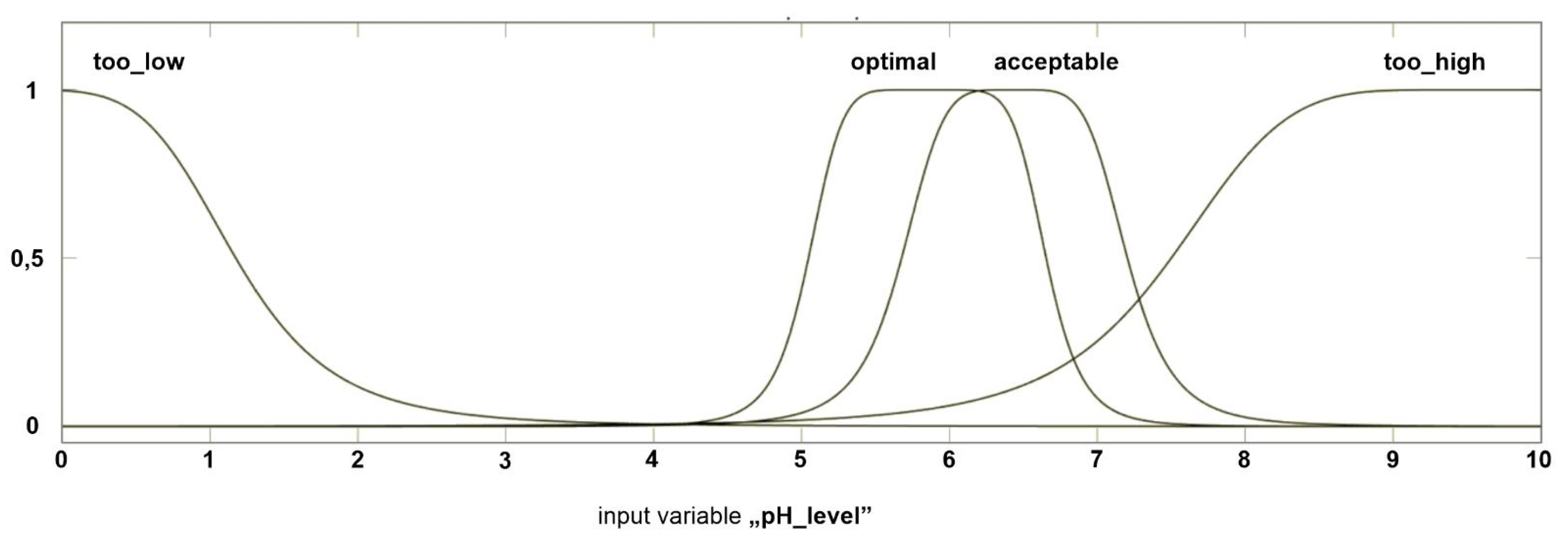
pH levelMake a test of soil pH—when pH is between 5.5 and 6.5 the site is optimal when it is below 5.5—there might be a problem with phosphorus deficiency and aluminium toxicity; pH up to 7.5 is acceptable, but above 7.5 vines may develop zinc and iron chlorosis deficiency; to influence nutrition uptake pH between 5.0 and 6.0 will be optimal [8].
Stone contentChoose the site that does not have excessive stone content; rocks on or near the surface are not desirable [8].
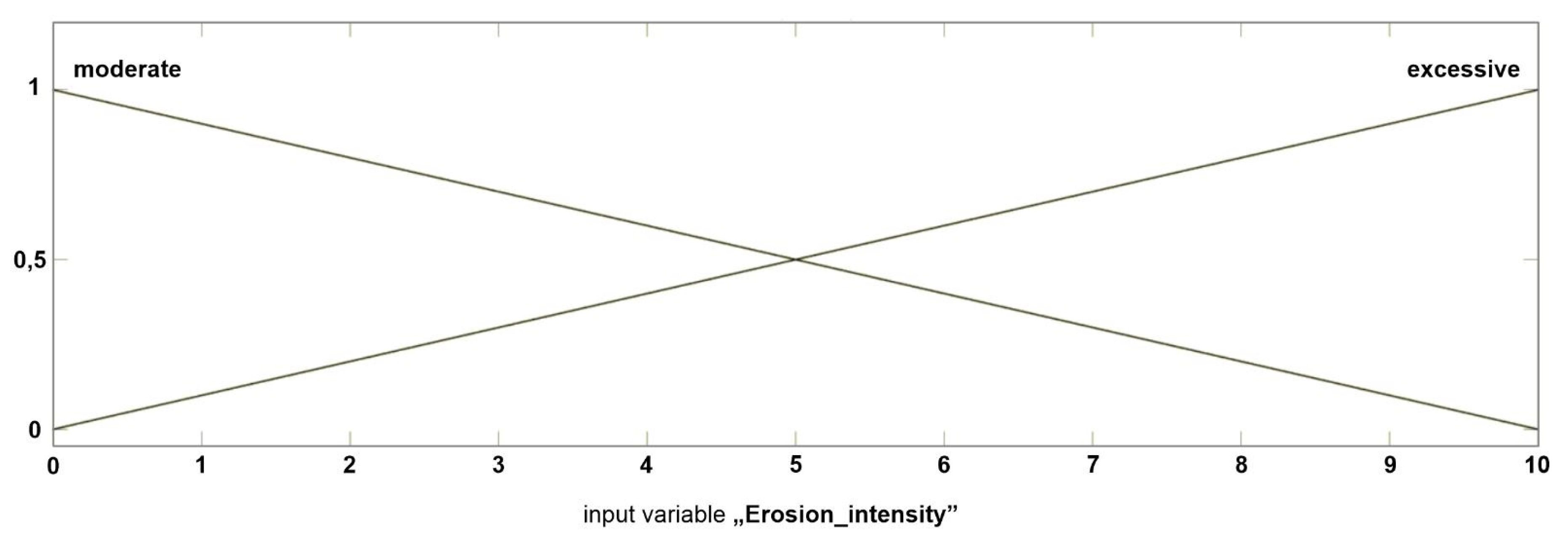
Erosion intensityChoose the site that does not have excessive erosion of topsoil [8].
Heat accumulation Too little heat accumulation can stunt grape ripening, while too much heat shortens the growing season and does not allow for proper development of flavour [8]; the newest research present that sites with light-colored soils (arenaceous or calcareous) can improve the wine quality. This type of soil reflects the light—fruits are better enriched with light, and in their rind, there are more polyphenolic compounds [61].
Climate
FrostChoose the site where the cold air is drained quickly from the ground; avoid concave land (where the cold air would settle); slopes and vineyard borders without barriers (like buildings or trees) provide good air drainage [8]; the range of frost basin can be determined by observation of spring and autumn hoarfrost (around 6 a.m.) and appearance of half-day and nightly fog [58]; the evening walk in late summer or autumn can also be a valuable experience—when walking down the slope the feeling of chill should appear—below this site the vineyard should not be located [62].
Winter injuryDo not plant grapes in wet, low-lying areas of the site [8].
Rainfall shadowsToo much rain can lead to enormous compaction if the soil is in poor condition, and also more insects may appear; analyze the distribution of rain using climate data services or talking to winegrowers to find “rain shadows”—areas that receive less rain than their surroundings [8].
WindChoose the places that are relatively secluded and shielded from north and west; light wind (2–3 m/s) has a positive influence on the health of vine by hampering the growth of fungal diseases; the heavy wind has a negative influence on the microclimate of the vineyard [62].
Other
Local winegrower examinationWalk the site with local winegrower who can examine the whole property with the knowledge of local conditions.
SurroundingsObserve the surrounding of the site—trees, buildings, hills, and other barriers that interrupt the vineyard, especially from south and west are not desirable [8,62].
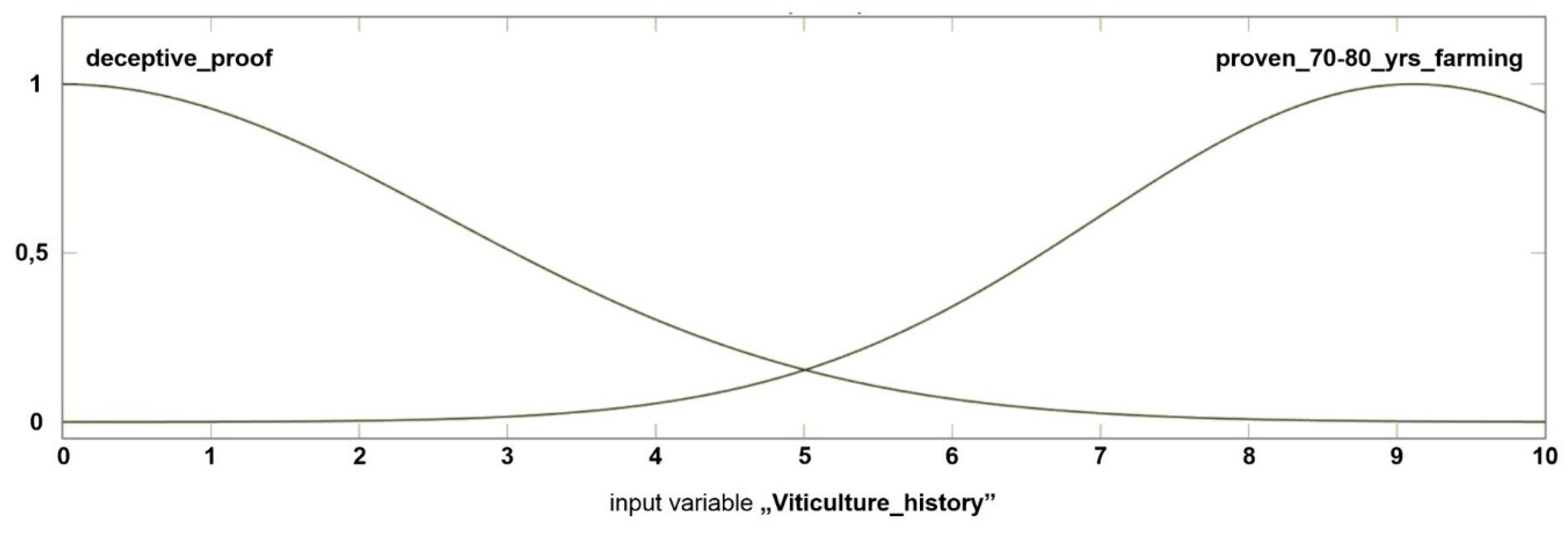
History of viticulture at the siteThe historical localization of vineyards can be the proof of good site, but only if these vineyards had economic value and survived for 70–80 years; the localizations of small garden vineyards are not good factors, while they were often planted as a decoration and not for economic reasons [63]; it is also important to notice that in the past, vineyard districts were stated based on trade area localization and not always connected with the terroir of the site [64].
Table 2. Membership functions characteristics for variables within each thematic group.
VariableType of Membership FunctionRangeNo. of Functions
Topography
ElevationPi-shaped0–103
River valleyGeneralized bell-shaped0–103
Water reservoirTrapezoidal0–102
Soil
Internal water drainageGeneralized bell-shaped0–604
pH levelGeneralized bell-shaped0–104
Stone contentGaussian combination0–102
Erosion intensityTriangular0–102
Heat accumulationGeneralized bell-shaped0–103
Climate
Frost—air drainageTriangular0–103
Frost—cooling sensationGaussian combination0–103
Winter injuryGeneralized bell-shaped0–103
Rainfall shadowsGaussian0–103
WindTrapezoidal0–102
Other
Local winegrower examinationTriangular0–103
SurroundingsProduct of two sigmoidal0–102
History of viticulture at the siteGaussian0–102
Table 3. Set of supporting queries for variables assessment.
VariableSupporting Queries
ElevationTo what extent the elevation satisfy the “sweet spot” parameters?
River valleyHow vast is the river valley?
Water reservoirHow well does the reservoir satisfy its desired parameters?
Internal water drainageHow many hours does the water stand on the field?
pH levelWhat is the measured pH level?
Stone contentAre there many rocks on or near the surface of the field?
Erosion intensityHow excessive is the erosion of the topsoil?
Heat accumulationWhat is the dominant color of the soil?
Frost—air drainageAre there any obstacles to air drainage?
Frost—cooling sensationWhat is the sensation, according to the “evening walk” test?
Winter injuryWhat is the content of wet, low-lying areas?
Rainfall shadowsHow frequent are rainfalls?
WindWhat is the intensity of the wind?
Local winegrower examinationHow does the local grower assess the site?
SurroundingsAre there many interrupting surroundings?
History of viticulture at the siteHow good is your proof of proper prior viticultures at the site?
Table 4. General rules for functions interactions.
Fuzzy Inference SystemMamdani
AND methodMIN
OR methodMAX
ImplicationMIN
AggregationMAX
DefuzzificationCentroid
Table 5. Simulation of assessing model performance.
ScenarioGISTopographySoilClimateOtherAssessmentSuitability
10.505.05.05.05.04.48Average
20.307.56.33.61.22.84Bad
30.877.86.87.28.66.46Average
40.593.52.92.65.04.01Average
50.810.41.14.06.93.60Average
60.948.88.58.89.27.64Good
70.775.46.16.07.34.90Average
80.5708.808.12.01Bad
90.909.37.08.18.16.95Good
1011010101010.00Good

