Abstract
The evolving capabilities of Geographic Information Systems (GISs) are transforming various industries, including e-commerce, by providing enhanced spatial analysis and precision in customer targeting, and improving the ability of recommender systems. This paper proposes a novel framework that integrates mobile agents with GISs to deliver real-time, personalized recommendations in e-commerce. By utilizing the OpenStreetMap API for geographic mapping and the Java Agent Development Environment (JADE) platform for mobile agents, the system leverages both geospatial data and customer preferences to offer highly relevant product suggestions based on location and behaviour. Mobile agents enable real-time data collection, processing, and interaction with customers, facilitating dynamic adaptations to their needs. The combination of GISs and mobile agents enhances the system’s ability to analyze spatial data, providing tailored recommendations that align with user preferences and geographic context. This integrated approach not only improves the online shopping experience but also introduces new opportunities for location-specific marketing strategies, boosting the effectiveness of targeted advertising. The validation of this system highlights its potential to significantly enhance customer engagement and satisfaction through context-aware recommendations. The integration of GISs and mobile agents lays a strong foundation for future advancements in personalized e-commerce solutions, offering a scalable model for businesses looking to optimize marketing efforts and customer experiences.
1. Introduction
E-commerce encompasses the buying and selling of goods and services over the Internet []. While traditional e-commerce systems have focused primarily on transaction processing and basic recommendation systems, the integration of Geographic Information Systems (GISs) and mobile agents is opening new possibilities for enhanced customer experiences and personalized service delivery. Geographic Information Systems (GISs) are specialized software systems designed to capture, store, manipulate, analyze, manage, and present various types of spatial or geographical data []. In e-commerce, GISs can provide crucial insights into customer behavior and market dynamics by analyzing spatial relationships between customers, products, and services. Over the past three decades, researchers have studied the application of GISs in e-commerce. However, a significant challenge in modern e-commerce is the ability to provide real-time, location-aware recommendations that adapt to changing customer contexts and preferences. Traditional recommendation systems often fail to incorporate geographical context and real-time customer behavior effectively. As a result of the decade-long surge in network technology and the widespread use of the Internet and World Wide Web (WWW) [], GISs (Geographic Information Systems) have seen a shift from the initial closed and centralized model of information management to an open model, which allows the vast amount of data managed by the many different types of GISs located throughout the world to be viewed by the public via the Internet at nearly every location [].
Furthermore, modern GISs’ performance depends on consistent network connectivity and a large amount of transmission capacity due to the prevalent Client/Server design []. The issue stems from the fact that the widely used distributed computing paradigm and GIS design could not effectively handle the demands of the rapidly developing application sectors, such as mobile computing, intelligent search, active services, and others, nor adapt to the Internet environment []. For distributed GISs in the context of the Internet, such a scenario necessitates the development of novel architecture and distributed computing technologies.
A relatively new paradigm in computing called a mobile agent is ideal for open and constantly changing settings since it blends distributed and agent technologies []. If a distributed GIS is used in an Internet setting with intermittent and constrained bandwidth for communication, this might be a useful method of introducing a mobile agent computing paradigm [].
A novel approach to tailored offers is the integration of mobile agents with Geographic Information Systems (GISs) in the context of e-commerce []. Engaging in autonomous activities, mobile agents on systems like Aglet or JADE can actively gather data in real time while roaming the network []. These agents take into account the user’s existing environment and serve as adaptable intermediaries between particular client preferences and the accessible product catalogue [,]. GISs give retailers more insight into the factors influencing customer preferences and behavior through data []. They may help them understand why transactions occur where they do by mapping a location against transactions and then aggregating the transactions to find patterns in the data. Location intelligence helps businesses make better decisions about inventory, sales, and marketing by helping merchants understand their customers.
In terms of providing region-specific offers and tailored ads, traditional geolocation-based systems have advanced significantly. In order to customize marketing campaigns according to users’ locations, platforms such as Google Ads and Facebook Ads employ geolocation data, which include GPS, Wi-Fi, and IP-based monitoring. These systems’ dependence on static geolocation data, which ignore real-time location changes and the dynamic nature of client activity, is a drawback. Even though traditional e-commerce platforms, similar to those used by Amazon and Walmart, have incorporated geolocation for targeted reduction and regional inventory operation, they still struggle to give recommendations that are really adapted and contextually aware [].
The capabilities of mobile agents and GIS technologies are combined in our suggested framework to provide a more flexible and dynamic solution. Real-time location information and autonomous mobile agents are incorporated in our system to provide tailored recommendations that adapt to the changing experience and activity of customers. To provide timely and relevant product suggestions, our system leverages both geographical and temporal data, in contrast to existing solutions that frequently depend on static data and lack adaptability. Its dynamic flexibility makes it more suitable for the needs of contemporary e-commerce and marks a substantial improvement over conventional geolocation-based solutions [].
This research proposes an innovative framework that leverages advanced geospatial technologies and mobile agent systems to transform e-commerce recommendation systems. By integrating real-time location data with autonomous mobile agents, our approach aims to address the fundamental challenges in delivering personalized, context-aware shopping experiences. Through a comprehensive analysis of existing e-commerce systems and their limitations in handling spatial data, we have identified three critical research questions:
- “How can mobile agents be effectively integrated with GISs to create a real-time, location-aware recommendation system that improves store recommendation accuracy in e-commerce?”
- “What impact does the combination of geographic distance calculations and user ratings have on the quality of store recommendations in a mobile agent-based e-commerce system?”
- “How can a temporal analysis of customer-product interactions be integrated with spatial data to enhance the precision of retail store recommendations?”
To address these questions, we have developed a comprehensive framework that combines mobile agent architecture with GIS capabilities, specifically designed for modern e-commerce environments. Our approach not only answers these fundamental questions but also makes several key technical contributions that advance the field of location-aware recommendation systems:
- The development of a comprehensive framework that integrates GIS capabilities with e-commerce platforms through mobile agents, enabling a new generation of spatially aware recommendation systems;
- The development of a novel scoring system that combines Haversine formula-based distance calculations with user ratings (δ = 0.7 and σ = 0.3) for optimal store recommendations;
- The implementation of a multi-agent framework using JADE that integrates six specialized agents for different aspects of the recommendation process;
- The creation of a temporal analysis system for tracking and analyzing customer–product interactions within physical retail spaces;
- The integration of multiple GIS databases with mobile agents to provide real-time location-aware recommendations for retail stores;
- The validation of the framework through a real-world case study with Carrefour and Monoprix, demonstrating an improved recommendation accuracy.
This paper is organized as follows. In Section 2, we present definitions for the technology used: GISs and mobile agents. Section 3 introduces the related works, in which the main references for the topic are displayed; Section 4 presents the methodology of the proposed solution adopted in this paper. Section 5 details the experimental results and the main results of a web application of this approach. Discussion is provided in Section 6. Section 7 addresses the limitations of the study. Finally, Section 8 concludes the paper and outlines potential future directions of the research
2. Background and Core Technologies
The dynamic nature of e-commerce systems necessitates the integration of advanced technological frameworks to maintain market competitiveness. Mobile agent technology and Geographic Information Systems (GISs) represent two significant technological paradigms that have fundamentally transformed the implementation of personalized service delivery in digital commerce platforms.
2.1. Geographic Information Systems (GISs)
A GIS stands for a Geographic Information System. It is a system intended to catch, store, manipulate, analyze, and manage current geographical data [], as illustrated in Figure 1.
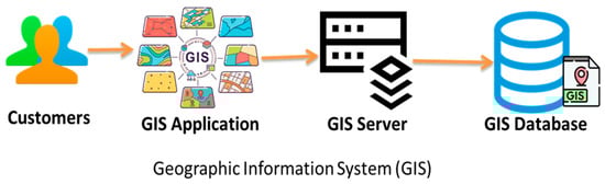
Figure 1.
Geographic Information System.
The term “Geographic Information System” (GIS) refers to both a generic method for organizing and analyzing large amounts of geographical data and a computer system that gathers, stores, organizes, analyzes, displays, and applies geographic information [].
2.2. Mobile Agents
A mobile agent is a software program or script that can autonomously move through and interact with computing environments. Unlike traditional programs that require continuous execution on a specific host, mobile agents can migrate from one system to another within a network to perform tasks. Mobile agents have key characteristics [].
Their autonomy allows them to make decisions and execute tasks without continuous supervision. In addition, communication amid computing nodes within a network allows for collaborative responses.
- Adaptability: They are flexible, capable of operating in several backdrops and achieving a variety of missions;
- They communicate with other agents, services, or users to exchange information or coordinate activities;
- To prevent unauthorized access or tampering, secure communication and execution are incorporated.
Mobile agents can be deployed across various domains including network operations, distributed computing, e-commerce, and resource allocation. These autonomous software entities possess the capability to navigate distributed environments independently, executing complex tasks while optimizing system efficiency. Their distributed nature enables efficient load balancing, reduced network traffic, and enhanced system flexibility through asynchronous execution and local processing capabilities [,,]. Figure 2 shows the versatility of mobile agents in a distributed system, showcasing their generic functionality in various contexts like task execution, secure communication, and collaboration across nodes.
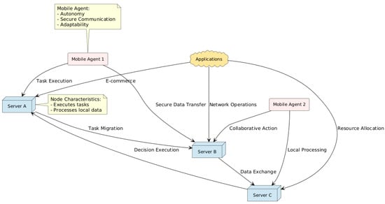
Figure 2.
Versatility of mobile agents in distributed system.
3. Related Works
This section reviews the literature on recommendation systems’ application to mobile agents and e-commerce applications based on Geographic Information Systems (GISs). We will examine a number of studies that are pertinent to our research topics in order to find any gaps in the body of knowledge.
The work reported in [] presents the benefits for both service providers and customers as they talk about the importance of product recommendations for e-commerce. Conventional methods, however, frequently depend on long-term contexts, whereas user preferences change quickly depending on location and behavior. They suggest a location-centric hybrid prediction model (HLCP) that considers the dynamic characteristics of user behavior to meet these shifting needs. According to experimental results, the HLCP model outperforms the existing models regarding the hit rate (HR) and mean reciprocal rate (MMR). By taking user location and real-time behavior into account, this novel method seeks to improve the relevance of recommendations in e-commerce. In response to these obstacles, the study described in this paper provides a location-centric hybrid prediction model (HLCP) that can effectively learn both short- and long-term contexts.
The authors of [] propose a novel framework introducing an intelligent tourist recommendation system aimed at addressing the challenges associated with filtering large volumes of information and products in virtual environments. By employing a collaborative filtering methodology, the system seeks to alleviate the cold-start issue for newly registered users by customising recommendations according to specific user preferences and by incorporating data gathered from the Flickr network. The study outlines a conceptual model comprising nine essential components, featuring enhanced techniques such as DBScan clustering and the Haversine similarity criterion to improve both accuracy and overall effectiveness. Furthermore, the model facilitates personalised travel suggestions, assisting users in effectively planning and managing their time. Its capabilities are projected to expand further, with prospective enhancements including the incorporation of neural networks for quicker response times and the integration of interactive algorithms—such as Gray Wolf and Dragonfly—to enhance clustering performance.
The research presented in [] focuses on a crucial aspect of e-commerce, which is product recommendations to customers. They aim to enhance the relevance of these recommendations by using more efficient recommendation techniques to optimize the overall sales and profits of a website. This experiment considers the users’ preferences, their network of relationships, and the distances separating them from other users. Combining these parameters with recommendation techniques, the final weight is merged with the two sets to obtain the definitive recommendations to present to the customer. Experimental data indicate that the personalized recommendation algorithm based on location services in this article outperforms traditional recommendation approaches based on content or collaborative filtering. The results of these experiments demonstrate that, with three users as the experiment subjects, the average precision of the recommendation system varies depending on the parameter settings, with values of 0.288, 0.303, and 0.361, respectively. The experimental software presented in this article improves users’ capacity to make recommendations to friends with similar tastes while also identifying prospective new friends.
The paper in [] discusses the development of the database, domain modelling, and establishing an architecture for a mobile Android application. The study fully explains the features of an e-commerce application that incorporates geolocation, providing an appropriate solution to the issues connected with offline purchases. The paper appears to stress the function of geolocation in e-commerce, emphasizing the importance of mobile applications in the online buying experience. The post will most likely address the significant benefits of incorporating geolocation into e-commerce systems. This might involve improving the tailoring of offers depending on user location, boosting the geographical relevance of items and services, and optimizing the online purchasing process’s efficiency.
The work reported in [] offers a comprehensive approach to minimizing transportation costs associated with the collection and delivery of tree logs. The study examines the complex dynamics of a pickup and delivery supply chain using agent-based modeling (ABM), in which individual units function as independent agents that interact with one another. The model incorporates a number of elements, such as the randomization of tree log pickup sites, the identification of possible facility locations, and the use of Geographic Information Systems (GISs) for routing. It also covers important logistical topics including trip lengths, fleet size, and the use of both trucks and trains for transportation. Time series charts, which monitor variables like the number of vehicles in use, facility inventories, and trip length, are used to display the results of the ABM. The study determines the best fleet sizes and facility locations by examining several simulation scenarios, offering important insights for the effective management of forest supply chains in the face of erratic demand.
The study presented in [] contributes an approach to understanding and implementing agent-based models (ABMs) in conjunction with Geographical Information Systems (GISs) within the context of big data and computational social science. It covers essential concepts from basic to advanced model construction, providing practical examples and code developed in Net Logo, along with supplementary online resources. The book’s main strengths lie in its practical approach, which combines theory with hands-on examples, allowing readers to apply ABM techniques effectively. The integration of ABM with GIS opens new avenues for spatial data analysis across various fields, making it a valuable resource for researchers and practitioners. However, beginners may find the complexity of ABM and GIS concepts challenging, and the examples provided might not cover all scenarios.
The work described in [] examines how integrating a business intelligence framework with a Geographic Information System (GIS) can improve franchise approval decisions at Coffee Refresh. The research centers on Jong, a senior analytics specialist, and his team’s attempts to resolve franchise request approval delays caused by arbitrary assessments of location accessibility and prospective consumer numbers. With eight petitions still pending and a growing number of new branches closing, Jong’s team wants to improve the approval process by analyzing geographical data and projected earnings using business intelligence. This example demonstrates how business information and a GIS may facilitate strategic franchise growth and expedite decision making.
The research detailed in [] explores the agent-based modeling approach, which is increasingly utilized in fields like geography, ecology, and economics to study complex socio-environmental systems. It highlights how crucial it is to have software platforms that are easily available so that people without extensive computer science training may effectively construct models. GAMA is unique among platforms since it was created especially for creating intricate, large-scale models with a spatial focus. The article introduces GAMA 1.8, emphasizing its sophisticated features and easy-to-use modeling language, as demonstrated by a number of examples that show off how well it can handle spatial dimensions in complicated systems.
Research that explore the development of a 3D visualization design system for landscape architecture, leveraging artificial intelligence (AI) and advancements in computer technology has emerged such as in []. Such advancements supported the transition from conventional two-dimensional Geographic Information Systems (GISs) to more dynamic and interactive three-dimensional (3D) systems that improve decision-making in a variety of industries, including e-commerce, and enable multidimensional data processing. In addition to outlining the system’s architecture, data collection techniques, and classification of landscape architecture information, the research highlights the significance of displaying landscape design as a crucial component of 3D GISs. The authors want to increase operational efficiency and effectively handle 3D landscape data by putting in place an object-oriented spatial relational database. The system’s capabilities are further improved by the combination of component-based architecture with AI technology, opening the door for clever landscape architecture applications.
The study documented in [] introduces the challenges tourists face in selecting places of interest due to the overwhelming amount of information available online. It highlights how crucial it is to employ sentiment analysis to examine user-generated information from social media sites, including reviews and comments. By classifying textual data into three sentiment categories—positive, negative, and neutral—this technique offers insights into what users think about different places. The study examines several recommendation models, emphasizing the efficacy of the Random Forest and Bi-LSTM techniques, with a Random Forest model attaining an 85% accuracy and a Bi-LSTM reaching around 84.7%. The study concludes by showing how sentiment analysis may improve geographic recommendation systems by giving users more accurate and pertinent choices. Table 1 presents a comparative assessment of relevant research in this field using key criteria, multiple sources, cloud boot-up problems, implementation methods, and adaptation strategies. Several sources provide varied data integration, which is necessary for precise suggestions. The cloud boot-up problem deals with issues related to cloud startup that impact system responsiveness. The practicality and scalability of deployment are evaluated by implementation techniques, and the adaptability of each system to evolving user behavior is evaluated by adaptation strategies. By highlighting the systems’ advantages and disadvantages, these criteria together provide insight on how well suited they are for actual e-commerce.

Table 1.
Comparative assessment in connection with relevant research in the field.
In [], the authors present a novel approach for modelling mobility dynamics using a GIS and Agent-Based Modelling (ABM) to investigate Mesolithic human mobility in Orkney. ABM finds “natural corridors” without set destinations by simulating least-cost travel, whereas a GIS recreates the old terrain, giving a baseline for mobility analysis. This method ignores sociopolitical influences in favor of concentrating on the influence of the natural environment on movement. In addition to providing a scalable framework for comprehending prehistoric human behavior in various circumstances, the study assists in finding archaeological potential. Similar to this, the authors in [] present a sophisticated framework for precision agriculture’s spatiotemporal semantic data management. The framework tackles issues with interoperability, standardization, and data management by utilizing IoT sensors placed across farms. It has a query system that helps farmers automate processes, keep an eye on operations, and make well-informed judgments. The approach incorporates a neural network for forecasting forage crop yields and has been validated against the European smart farming platforms AFarCloud and DEMETER. Precision agriculture techniques are advanced by this method’s excellent performance in managing intricate spatiotemporal queries and smooth service interoperability with external agricultural data models.
According to the literature study, e-commerce has made extensive use of tried-and-true techniques including content-based filtering, collaborative filtering, and hybrid recommendation systems for product suggestions. These approaches, however, frequently fall short in meeting the dynamic, real-time requirements of contemporary e-commerce settings. Although separate research has shown the advantages of mobile agent technologies [,] and GIS integration in recommendation systems [,], there is a clear research vacuum in which both strategies are coupled to provide an adaptive, real-time, location-aware recommendation system. As Table 1 illustrates, existing methods often concentrate on static location data [,] or struggle with limited flexibility since mobile agents are not included. Furthermore, these systems frequently have trouble managing several data sources efficiently while being responsive, which is essential for tailored suggestions in real time. Through the integration of mobile agents with GIS capabilities, our suggested approach directly tackles these issues. This connection enhances the system’s ability to integrate numerous data sources effectively in addition to enabling dynamic adaptations to real-time user contexts and locations. Our methodology overcomes the drawbacks of conventional approaches by integrating GISs and mobile agents to provide a more reliable, scalable, and responsive solution for e-commerce customization. This guarantees that our recommendation engine will be able to provide recommendations that are more precise, fast, and context-aware, marking a major breakthrough in the area of e-commerce customization.
4. Research Methods
The proposed framework integrates mobile agent technology with GIS capabilities to create a dynamic, location-aware recommendation system for e-commerce. This novel approach combines real-time geographical data processing with autonomous mobile agents to deliver personalized product recommendations. The framework consists of three main layers: the user interaction layer, the agent processing layer, and the GIS integration layer, working in concert to provide contextually relevant suggestions to users while optimizing system performance and resource utilization.
4.1. System Architecture and Components
The proposed framework integrates mobile agent technology with GIS capabilities through a multi-layered architecture designed to provide dynamic, location-aware recommendations in e-commerce environments. Figure 3 illustrates the system architecture, which implements sophisticated strategies for agent communication, migration, and collaboration while maintaining data consistency across distributed components.
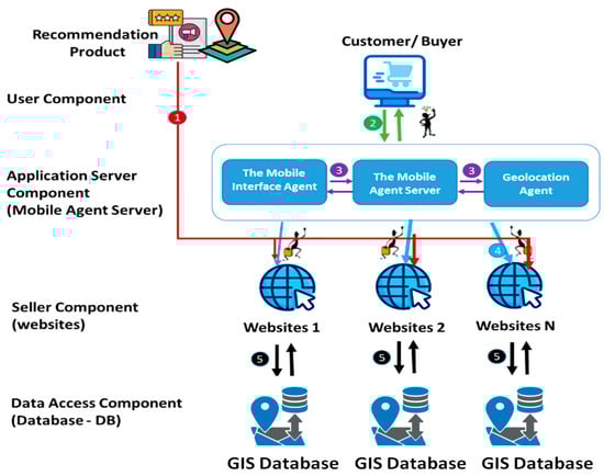
Figure 3.
Detailed system architecture.
The system follows a structured flow where each step represents a critical interaction between components, as shown in Table 2.
Table 2.
Explanation of steps in the GIS-based recommendation system.
The architecture consists of five primary components, each serving distinct yet interconnected functions in the recommendation process, as shown in Table 3.
Table 3.
Core architectural components and their function.
The system operates through a series of coordinated interactions:
- Data Flow: The mobile agent server facilitates communication between user requests and the distributed GIS databases, enabling a real-time spatial analysis and recommendation generation;
- Agent Migration: Mobile agents traverse the network to gather information from multiple websites and GIS databases, optimizing data collection and processing efficiency;
- Integration Layer: The application server component acts as an integration layer, coordinating communication between mobile agents and the GIS databases while managing system resources and load balancing;
- Database Interaction: Each seller’s website maintains its own GIS database, allowing for a localized spatial analysis while contributing to the global recommendation system through the mobile agent network.
This architecture enables several key capabilities through its integrated design. The system provides real-time location-aware recommendations while supporting distributed data processing and analysis across the network. Its structure allows for the scalable integration of multiple vendor systems, ensuring the platform can grow with market demands. The architecture dynamically adapts to user preferences and location changes, while maintaining efficient resource utilization through strategic mobile agent deployment.
The modular nature of this architecture allows for easy scaling and integration of new components while maintaining system performance and reliability. Through this design, the system can effectively process spatial data and user preferences to generate contextually relevant recommendations while optimizing resource utilization across the distributed network.
4.2. Inter-Agent Communication Framework
The system implements an advanced communication framework between multiple specialized agents to deliver personalized, location-aware recommendations. Figure 3 illustrates the multi-agent interaction model, in which each agent performs specific functions while maintaining synchronized communication with other system components, while Figure 4 provides a detailed structural view of the agent framework through a UML class diagram.
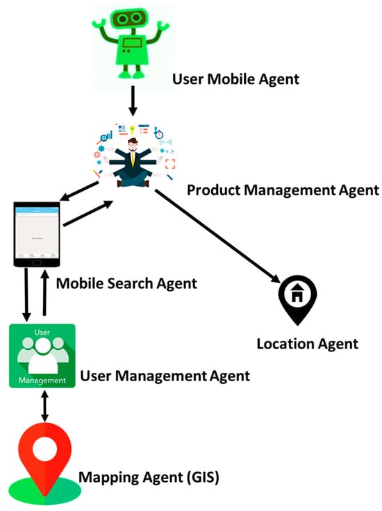
Figure 4.
Multi-agent system interaction diagram.
As shown in Figure 5, at the core of this framework, the user mobile agent serves as the primary interface between the customer and the system’s specialized agents. This agent orchestrates a complex network of interactions.
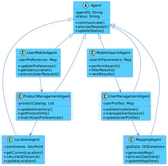
Figure 5.
UML diagram.
The product management agent processes product queries and manages inventory data, working in tandem with the mobile search agent to incorporate location-specific product availability. When a user initiates a search, the location agent provides real-time geographical coordinates that help contextualize the search parameters. This location data is then processed by the mapping agent (the GIS) to generate relevant spatial information, including store locations and delivery routes.
Security and user data management are handled by the user management agent, which maintains secure authentication protocols and manages user preferences across sessions. This agent ensures that all communications between other agents are properly authenticated, and that user data remain protected throughout the recommendation process.
The interaction flow is designed to minimize latency while maximizing data accuracy. When a user initiates a request, the system triggers a cascade of agent communications, with each agent contributing specific data or a functionality to generate comprehensive, location-aware recommendations. This coordinated approach ensures that users receive relevant suggestions based on their location, preferences, and real-time product availability.
The system employs asynchronous communication protocols to maintain responsiveness, allowing agents to process requests and update information independently while maintaining system coherence. This architecture enables the system to scale efficiently while providing consistent performance across varying load conditions.
4.3. System Workflow
The system implements a structured workflow that coordinates the interaction between customers, mobile agents, and GIS components to deliver personalized recommendations. Figure 6 illustrates the systematic process flow from the initial customer interaction to final feedback collection.
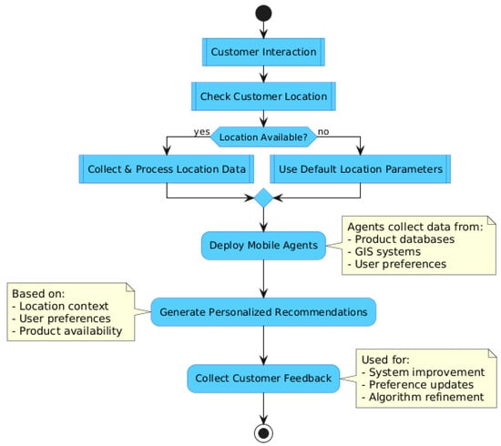
Figure 6.
A flow chart of the proposed system.
The workflow follows a decision-based path that begins with customer interaction and branches based on location data availability. This process encompasses several key phases:
- Initial Customer Interaction: The system engages with the user through the interface, initiating the recommendation process;
- Location Verification: The system checks for customer location data availability, creating two possible paths: (1) when a location is available, the system collects and processes precise location data; and (2) when a location is unavailable, the system defaults to standard location parameters;
- Mobile Agent Deployment: Based on the available data, relevant mobile agents are activated to gather and process information;
- Recommendation Generation: The system synthesizes collected data to create personalized product suggestions;
- Feedback Collection: Customer responses are gathered to continuously improve the recommendation engine.
This systematic approach ensures efficient resource utilization while maintaining service quality. The workflow’s branching structure allows the system to provide relevant recommendations regardless of location data availability, ensuring consistent service delivery across various usage scenarios. The integration of mobile agents at the deployment stage enables dynamic data collection and processing, while GIS components provide crucial spatial context for enhanced recommendation accuracy when location data are available.
The final feedback collection phase creates a continuous improvement loop, where customer responses help refine and optimize the recommendation algorithm for future interactions. This creates a self-improving system that becomes more accurate and effective over time.
5. Experimental Results
This section presents the main conclusions and experimental data used to evaluate a product recommendation system.
5.1. Case Study
This case study displays an innovative approach to enhance product suggestions for customers who frequently shop at Carrefour and Monoprix. The foundation of this innovation is the seamless integration of Geographic Information Systems (GISs) with mobile agents. Our primary objective is to combine user mobility with geospatial data to deliver a shopping experience that is both intrinsically relevant and personalized.
The foundation of our proposed solution is developing a system designed to facilitate mobile agent interactions with customers on the Carrefour and Monoprix websites. In their capacity as data collectors, these mobile agents collect data in real time regarding users’ locations, their inclination to make purchases, and the range of goods and promotions offered in nearby stores.
The numerous benefits of this strategy can help both the stores and the customers. Consumers will receive customized product recommendations based on their current location, personal preferences, and the specific products available near Carrefour and Monoprix stores. As a result, the offers clearly show the influence of geolocation and personalization.
The case study will explore the technical details of this novel solution, clarifying the complexities of customer interactions with mobile agents, their smooth interaction with store websites, the real-time updating mechanisms, and the clever use of geospatial data to optimize the recommendation engine.
Essentially, this case study’s findings will offer indisputable proof of the effectiveness of this strategy. We want to emphasize the revolutionary potential of this innovation in retail by displaying how it increases customer satisfaction, drives in-store sales, and improves the relevance of product recommendations. By demonstrating how the combination of mobile agents and GISs can transform the shopping experience for discriminating customers who frequent Carrefour and Monoprix stores, we hope to further the evolution of the retail scene.
5.2. Scenario
The following is a scenario of a use case in which score/distance are calculated using the Haversine formula to form a recommendation.
- The user, a client, lives in Tunisia City (latitude: 40.7128, longitude: −74.0560).
- The user needs a store recommendation; three stores have the following ratings and locations:
- Store Shop AA: intermediate rating by similar customers (4.5), located in Ariana (latitude: 40.6782, longitude: −73.9442);
- Store Shop BB: intermediate rating by similar customers (4.0), located in Ben Arous (latitude: 40.7831, longitude: −73.9712);
- Store Shop CC: intermediate rating by similar customers (3.5), located in Manouba (latitude: 40.7282, longitude: −73.7949).
Suppose a user x is in location (ϕx,λx), and we want to recommend a product y located at (ϕy,λy) in Equation (1):
Calculate the prediction of customer ratings:
Using Equation (2), the Haversine theorem may be applied to calculate the distance:
Considering the two places’ longitude and latitude, the Haversine formula can be used for determining the distance between them (d), where r = 6371 km.
In Equation (2), are latitude and longitude.
The distance from Tunisia to Shop AA (Ariana) is as follows:
The distance from Tunisia to Shop BB (Ben Arous): 3.92 km.
The distance from Tunisia to Shop CC (Manouba): 7.88 km.
To calculate the score for recommendations, we can use Equation (3).
In Equation (3), and are height balancing, the score prediction, and the distance item.
According to the equation, = 0.7 and = 0.3.
Shop AA:
Shop BB:
Shop CC:
From the results we obtained the best recommendations, which are shown below:
Store AA: Score = 3.20.
Store BB: Score = 2.90.
Store CC: Score = 2.50.
So, Shop AA in Ben Arous is the recommended decision for the customer. Combining mobile agents with Geographic Information Systems, these equations can provide individualized, location-aware suggestions for online purchases, as shown in Figure 7.
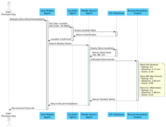
Figure 7.
Sequence diagram.
5.3. Expanded Scenarios for Validation
Several scenarios with different user locations and dynamic user motions have been included in the assessment in order to better evaluate the suggested framework. These further examples show how the recommendation system may be used with mobile agents and geographic data while being resilient and flexible.
5.3.1. Scenario 1 (Existing): Static User Location
- User Location: Tunisia City (latitude: 40.7128, longitude: −74.0560).Stores:
- ➢
- Store AA (Ariana): Rating 4.5, Distance 3.92 km.
- ➢
- Store BB (Ben Arous): Rating 4.0, Distance 5.0 km.
- ➢
- Store CC (Manouba): Rating 3.5, Distance 7.88 km.
- Results:
Store AA is recommended due to its high rating and proximity, achieving the highest score of 3.20.
5.3.2. Scenario 2: User in Nabeul
- User Location: Nabeul (latitude: 40.7528, longitude: −73.9725).Stores:
- ➢
- Store DD (Nabeul): Rating 4.3, Distance 2.5 km.
- ➢
- Store EE (Sousse): Rating 3.8, Distance 5.0 km.
- Results:
Store DD receives the highest recommendation score due to its proximity and relatively high rating, as shown in Table 4.
Table 4.
Store performance evaluation.
5.3.3. Scenario 3: Dynamic User Movement
- User Movement: Simulated movement of the user across multiple locations:Start in Tunisia City → Move to Ariana → End in Nabeul.
- Validation Focus:
- ➢
- The adaptability of mobile agents to update recommendations in real time as the user changes location.
- ➢
- Demonstrates the system’s ability to process dynamic inputs and provide relevant suggestions.
5.4. Performance Validation
Three important metrics—accuracy, precision, and latency—are used to assess the performance of the suggested framework in order to verify it. By comparing recommendations to user preferences, accuracy assesses how accurate they are, and precision shows how well the recommendations match user expectations. In order to guarantee system responsiveness, latency measures how long it takes mobile agents to analyze and respond to recommendations. When combined, these indicators show how well the framework works to provide timely, relevant, and accurate location-aware suggestions, as shown in Table 5.
Table 5.
Performance results of the recommendation framework.
Figure 8 illustrates how well the recommendation system performed in three different scenarios: two using static user locations in Nabeul and Tunisia City, and one using dynamic user mobility. It shows the latency (ms) (red, secondary axis), accuracy (%) (blue), and precision (%) (green). While Scenario 3 exhibits a higher latency as a result of real-time processing, Scenario 1 attains the maximum accuracy and precision. The system’s capacity to deliver precise, timely, and pertinent recommendations under a range of user circumstances is depicted in the figure.
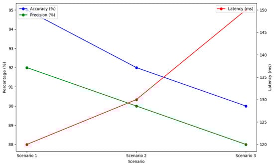
Figure 8.
Performance metrics for the recommendation framework.
5.5. Implementation
This section describes the technological platforms and technologies that were utilized to integrate our recommendation system’s web application, mobile agents, and the GIS, as shows in Table 6:
Table 6.
Summary of technologies and their applications.
5.5.1. Web Application
In this section, we present the interfaces with a description of the web application.
Figure 9 illustrates the detailed data collection process and temporal analysis of customer interactions with products. In this step, customers engage with various products in the supermarket, and the time spent in front of each product is recorded. Customers’ attention to each product can be inferred from this temporal analysis.
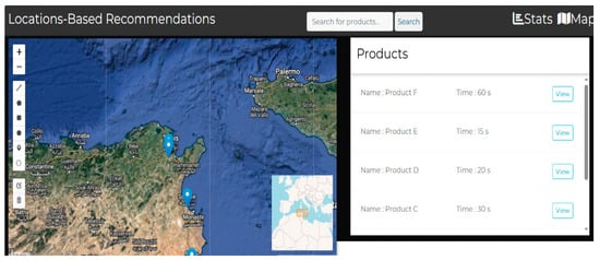
Figure 9.
Data collection and temporal analysis of customer–product interactions.
The integration of these temporal data into a virtual geographic map is shown in Figure 10. The location of a product in the supermarket is shown on the geographic map when a user clicks the “View” button for that particular product. It also indicates the average time customers spend interacting with this product. This visualization lets users comprehend how products are arranged in the actual supermarket space and how they draw in customers over time.
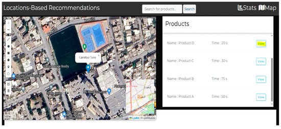
Figure 10.
Integration of temporal data into the geographic map.
Figure 11 shows how different stores are categorized according to how many products they sell to customers. It illustrates how retailers can be classified into various groups according to the range of goods they carry. Marketing researchers and store managers can use this classification to understand better how their store is positioned to the competition and to help them make strategic decisions about product offerings and inventory control.
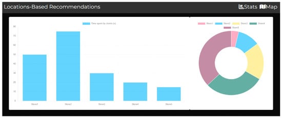
Figure 11.
“Top products” by store graph.
5.5.2. Creating Mobile Agents
In the section, we present how creating mobile agents involves developing software entities that can autonomously move between systems to perform various tasks and collect data. Security and communication mechanisms are essential considerations in their design, as shown in Figure 12.

Figure 12.
The mobile agents in our system.
5.5.3. Interactions Between Agents
Usually, when a mobile search agent and a location agent communicate, the mobile search agent request’s location information from the location agent. After receiving this request, the location agent returns the required location information to the mobile search agent. When the mobile search agent receives these data, they can be used to improve its search functions. Through this connection, both agents can work together efficiently when location-based information is needed, including geolocated search and navigation, as shown in Figure 13.
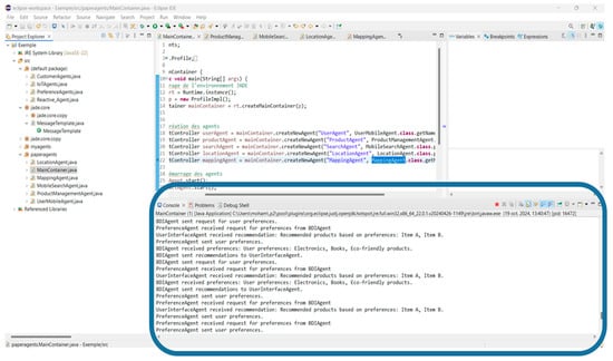
Figure 13.
Interactions between the agents.
5.5.4. An Overview of the Incorporated Approach
The interrelationship among different agents and vendors in a mobile agent and GIS-based recommendation system are described in the integrated system diagram, as shown in Figure 14. The figure offers information on how elements, included agents and vendors, cooperate and assist customers with customized suggestions.
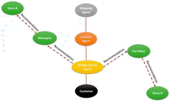
Figure 14.
Integrated diagram of agents and stores with interactions.
5.5.5. An Overview of the Locations of the Stores
A two-dimensional spread map demonstrating the positions of Carrefour, Monoprix, Shop A, Shop B, and other retail shops is shown in Figure 15. The latitude and longitude of these stores are displayed graphically in this figure, which sheds light on their geographical distribution.
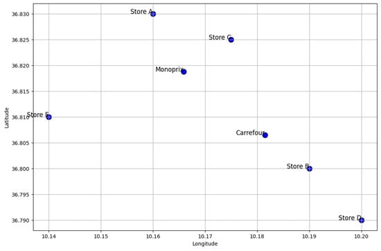
Figure 15.
Store locations: Carrefour, Monoprix, and others.
6. Discussion
The integration of mobile agents with GISs in e-commerce recommendation systems represents a significant advancement over traditional approaches. Our experimental results reveal several crucial insights into the system’s performance, technical innovation, and business impact.
6.1. Performance and Effectiveness
The empirical results from our case study with Carrefour and Monoprix demonstrate the system’s effectiveness in real-world scenarios. The integration of temporal analysis with geographic data provides more contextually relevant recommendations than traditional systems. Particularly noteworthy is the performance of the Haversine formula-based distance calculations combined with user ratings, which proved highly effective for store recommendations. This approach successfully balances proximity with user preferences, as evidenced by the scoring system’s performance across different store locations. Similar conclusions on the significance of geographic information in recommendation systems have been made by [], who stress that location-aware algorithms prioritize closeness in order to increase user happiness. Additionally, research by [] supports our findings about the influence of customer behavior patterns over time and emphasizes the need of incorporating temporal aspects into recommendation systems.
6.2. Technical Innovation
Our approach introduces significant technical innovations in e-commerce recommendation systems. The mobile agent framework enables immediate responses to changing user contexts, addressing a key limitation of traditional static recommendation systems. The integration of GISs provides deeper insights into user behavior patterns within physical retail spaces, while the sophisticated interaction between specialized agents enables more refined recommendation strategies. In their exploration of the application of GISs for spatial-temporal pattern analysis [], the authors showed how GIS technologies might reveal hidden tendencies in consumer behavior. Furthermore, the resilience of the JADE framework for dynamic data processing has been demonstrated by other experiments, such as that conducted by [], which confirmed its capacity to support mobile agent communication.
6.3. System Performance and User Experience
The system’s performance in processing both spatial and temporal data in real-time represents an advancement in recommendation technology. The integration of multiple development languages and databases has created a robust platform capable of handling complex geographical calculations while maintaining system responsiveness. Users now have a better knowledge of product placements and engagement patterns due to the web application’s ability to display temporal data with geographic mapping. The efficiency of the scoring system in integrating customer evaluations and geographic distance (δ = 0.7 and σ = 0.3) shows that the framework can provide accurate, location-aware suggestions while preserving computational efficiency. The importance of computational efficiency in GIS-based systems has previously been discussed by the authors in the Related Work section, who stress that location-aware applications require real-time processing. This is further supported by our results, which demonstrate the scalability of our methodology in large-scale retail environments.
6.4. Generalizability of the Framework and Future Validation Needs
The effectiveness of the suggested framework is demonstrated by the case study involving Carrefour and Monoprix; nevertheless, it is crucial to remember that depending solely on one use case restricts one’s capacity to extrapolate the findings to other retail settings. The unique data from the selected establishments and the consumer actions in these specific circumstances have an impact on the conclusions. Extended validation to several use cases including various retailer types (e.g., independent stores, Internet retailers, and local chains) and geographical regions is required to completely verify the suggested strategy. More thorough assessments of the framework’s flexibility and efficacy in other contexts are possible, producing results that are more trustworthy and broadly applicable. Furthermore, the validation of the system’s long-term effects on customer engagement and suggestion accuracy would be strengthened by extensive research using longitudinal data.
7. Limitations of the Study
The proposed approach has several limitations that should be taken into account. Firstly, the quality of geographic data is crucial to its efficacy; inaccurate data might result in suggestions that are not relevant and lower customer happiness. The system’s implementation necessitates a large investment in GIS infrastructure, which small- and medium-sized businesses may find difficult. Furthermore, even though the mobile agents allow for real-time adaption, a connection delay could make suggestions less responsive. Additionally, because it might not adequately capture quickly evolving behaviors across various consumer groups, the system struggles with the variety of user preferences. Moreover, it might be difficult and resource-intensive to integrate mobile agents with current GIS services and e-commerce systems, necessitating careful planning. Another issue is user adoption, as prospective users may be reluctant to embrace mobile agent technology because of misunderstandings or perceived difficulties with user interactions.
7.1. Privacy Considerations
The integration of Geographic Information Systems and mobile agents in e-commerce causes considerable privacy concerns that need to be examined. Customers may feel uneasy if they believe they are being watched, as their movements and actions are continuously tracked for location-based suggestions. Furthermore, there are hazards associated with data mining techniques when collecting and analyzing personal data in order to provide suggestions, which might lead to sensitive information being misused or accessed without authorization. Businesses must guarantee informed permission, provide choices for opting in or out of data collection, and clearly explain how user data will be used in order to allay these fears. Protecting individual privacy also requires the use of strong data anonymization techniques. Future research should concentrate on creating privacy-preserving systems that strike a compromise between user rights and the requirement for tailored suggestions, as well as making sure that data protection laws like the GDPR are followed.
7.2. Expanding Validation to Strengthen Conclusions
The framework’s validation is currently focused on a single use case, which restricts the results’ applicability to different kinds of merchants or geographic contexts. Future research should involve larger-scale studies that span many use cases to validate the framework’s adaptability to varied retail settings, product kinds, and data from other areas, even if this case study with Carrefour and Monoprix has shown encouraging findings. To assess the system’s adaptability in many market segments, future research should test it with merchants of varying sizes, such as independent shops, regional chains, and e-commerce platforms. To evaluate the framework’s effectiveness in various cultural and demographic situations, it is also essential to validate it in a variety of geographic locations. In order to assess the system’s long-term influence on consumer behavior and the suggestions’ ongoing applicability, longitudinal studies will also be required to examine its performance over lengthy time periods.
8. Conclusions and Future Work
This work presented a novel integration of GISs and mobile agent technologies in e-commerce recommendation systems, demonstrating advancements in personalized shopping experiences. The proposed framework successfully combined real-time location awareness with autonomous mobile agents to create a dynamic and responsive recommendation system. Our case study with Carrefour and Monoprix shows how the Haversine formula-based computations, when paired with the temporal monitoring of consumer behavior, have resulted in suggestions that are contextually appropriate. The experimental findings confirm that the system can analyze complex spatial-temporal data with computing efficiency. The scoring algorithm offers insightful suggestions that improve the shopping experience by skillfully balancing user preferences and geographic proximity.
The framework exhibits usefulness for both customers and retailers. Retailers may improve product placement and in-store layouts by integrating GISs and visualization technologies, which provide sophisticated data for location-based marketing, inventory management, and consumer interactions. Our results provide additional support for the significance of in-store product placement and its effect on consumer engagement, which have been emphasized in earlier research as a relevant factor. According to recent studies on the benefits of location-aware recommendations, the system offers customers a more tailored and contextually aware buying experience.
In order to improve suggestion accuracy and context awareness, future research will look at integrating ontology and semantic web technologies. The integration of cutting-edge machine learning approaches to enhance pattern identification and prediction skills will be investigated in more detail. Future developments will also concentrate on improving the system’s functionality in various geographic locations and e-commerce platforms, as well as creating increasingly sophisticated visualization tools for business information and consumer engagement.
Author Contributions
Conceptualization, M.S.; methodology, M.S. and S.H.; validation, M.S., M.E. and S.H.; formal analysis, M.S.; writing—original draft preparation, M.S. and S.H.; writing—review and editing, M.E.; supervision, M.E. All authors have read and agreed to the published version of the manuscript.
Funding
This research received no external funding.
Data Availability Statement
Data are available upon request from the authors.
Conflicts of Interest
The authors declare no conflicts of interest.
References
- Rosário, A.; Raimundo, R. Consumer Marketing Strategy and E-Commerce in the Last Decade: A Literature Review. J. Theor. Appl. Electron. Commer. Res. 2021, 16, 3003–3024. [Google Scholar] [CrossRef]
- Chow, T.E. A crowdsourcing–geocomputational framework of mobile crowd simulation and estimation. Cartogr. Geogr. Inf. Sci. 2019, 46, 2–20. [Google Scholar] [CrossRef]
- Wang, M.; Li, Q.; Lin, Y. A personalized search model using online social network data based on a holonicmultiagent system. China Commun. 2020, 17, 176–205. [Google Scholar] [CrossRef]
- Pawale, P.R.; Dhamdhere, V. Survey Paper on New Approach to Location Recommendation Using Scalable Content-Aware Collaborative Filtering. In Lecture Notes in Electrical Engineering; Springer: Berlin/Heidelberg, Germany, 2020; Volume 570, pp. 167–174. [Google Scholar] [CrossRef]
- Sun, L. POI Recommendation Method Based on Multi-Source Information Fusion Using Deep Learning in Location-Based Social Networks. J. Inf. Process. Syst. 2021, 17, 352–368. [Google Scholar] [CrossRef]
- Lu, X.; Zhang, H. A content-aware poi recommendation method in location-based social networks based on deep CNN and multi-objective immune optimization. J. Internet Technol. 2021, 21, 1761–1772. [Google Scholar] [CrossRef]
- Liao, J.; Liu, T.; Yin, H.; Chen, T.; Wang, J.; Wang, Y. An integrated model based on deep multimodal and rank learning for point-of-interest recommendation. World Wide Web 2021, 24, 631–655. [Google Scholar] [CrossRef]
- Kopecky, M.; Vojtas, P. Graphical E-Commerce Values Filtering Model in Spatial Database Framework. In Communications in Computer and Information Science; Springer: Berlin/Heidelberg, Germany, 2019; Volume 1064, pp. 210–220. [Google Scholar] [CrossRef]
- Liu, Y.; Cheng, D.; Pei, T.; Shu, H.; Ge, X.; Ma, T.; Du, Y.; Ou, Y.; Wang, M.; Xu, L. Inferring gender and age of customers in shopping malls via indoor positioning data. Environ. Plan. B Urban Anal. City Sci. 2020, 47, 1672–1689. [Google Scholar] [CrossRef]
- Li, W. A fleet manager that brings agents closer to resources: GIS Cup. In GIS: Proceedings of the ACM International Symposium on Advances in Geographic Information Systems; Association for Computing Machinery: New York, NY, USA, 2020; pp. 655–658. [Google Scholar] [CrossRef]
- Alhijawi, B.; Kilani, Y. The recommender system: A survey. Int. J. Adv. Intell. Paradig. 2020, 15, 229–251. [Google Scholar] [CrossRef]
- Mou, N.; Zhang, L.; Li, Q.; Liu, B. A new thinking: Personalized recommendations on spatial information. In Electrical, Information Engineering and Mechatronics 2011; Lecture Notes in Electrical Engineering; Springer: London, UK, 2012; Volume 138, pp. 1645–1652. [Google Scholar] [CrossRef]
- Xie, C.; He, D. Research on the construction of e-commerce precision poverty alleviation system based on geographic information. In Procedia Computer Science; Elsevier B.V.: Amsterdam, The Netherlands, 2020; Volume 166, pp. 111–114. [Google Scholar] [CrossRef]
- Bansal, D. Location based marketing: Issues and opportunities in the real world. In Enhancing Customer Engagement Through Location-Based Marketing; IGI Global: Hershey, PA, USA, 2023; pp. 44–55. [Google Scholar] [CrossRef]
- Guo, Y.; Yin, C.; Li, M.; Ren, X.; Liu, P. Mobile e-commerce recommendation system based on multi-source information fusion for sustainable e-business. Sustainability 2018, 10, 147. [Google Scholar] [CrossRef]
- Erdin, C.; Akbaş, H.E. A Comparative Analysis of Fuzzy TOPSIS and Geographic Information Systems (GIS) for the Location Selection of Shopping Malls: A Case Study from Turkey. Sustainability 2019, 11, 3837. [Google Scholar] [CrossRef]
- Li, X.; Yue, J.; Wang, S.; Luo, Y.; Su, C.; Zhou, J.; Xu, D.; Lu, H. Development of Geographic Information System Architecture Feature Analysis and Evolution Trend Research. Sustainability 2024, 16, 137. [Google Scholar] [CrossRef]
- Lü, G.; Batty, M.; Strobl, J.; Lin, H.; Zhu, A.X.; Chen, M. Reflections and speculations on the progress in Geographic Information Systems (GIS): A geographic perspective. Int. J. Geogr. Inf. Sci. 2019, 33, 346–367. [Google Scholar] [CrossRef]
- Haleema, P.K.; Iyengar, N.C.S.N. JADETraderPal—JADE mobile agent embedded with flexible negotiation strategies for dynamic e-commerce environments. J. King Saud Univ. Comput. Inf. Sci. 2020, 32, 829–849. [Google Scholar] [CrossRef]
- Paraschiv, D.M.; Titan, E.; Manea, D.I.; Ionescu, C.D.; Mihai, M.; Serban, O. The change in e-commerce in the context of the Coronavirus pandemic. Manag. Mark. 2022, 17, 220–233. [Google Scholar] [CrossRef]
- Liu, W.; Zhao, S.H.; Liang, W.; Liu, P. Research on Electronic Commerce Model based on Mobile Agent framework: A Case Study. In Proceedings of the 2011 4th International Conference on Information Management, Innovation Management and Industrial Engineering, ICIII 2011, Shenzhen, China, 26–27 November 2011; Volume 1, pp. 480–482. [Google Scholar] [CrossRef]
- Sreenivasa, B.R.; Nirmala, C.R. Hybrid location-centric e-Commerce recommendation model using dynamic behavioral traits of customer. Iran J. Comput. Sci. 2019, 2, 179–188. [Google Scholar] [CrossRef]
- Kianinezhad, I.; Bayati, M.; Harounabadi, A.; Akbari, D. Developing a Location-Based Recommender System Using Collaborative Filtering Technique in the Tourism Industry. Teh. Glas. 2022, 16, 53–59. [Google Scholar] [CrossRef]
- Ren, X. E-Commerce Recommendation Algorithm Based on Location Service. In Advances in Intelligent Systems and Computing; Springer Science and Business Media Deutschland GmbH: Berlin/Heidelberg, Germany, 2021; Volume 1384, pp. 58–64. [Google Scholar] [CrossRef]
- Chen, P. Research on Recommendation System Based on Location and Content; ACM International Conference Proceeding Series; Association for Computing Machinery: New York, NY, USA, 2021. [Google Scholar] [CrossRef]
- Helo, P.; Rouzafzoon, J. An agent-based simulation and logistics optimization model for managing uncertain demand in forest supply chains. Supply Chain Anal. 2023, 4, 100042. [Google Scholar] [CrossRef]
- Crooks, A.; Malleson, N.; Manley, E.; Heppenstall, A. Agent-Based Modelling & Geographical Information Systems: A Practical Primer; SAGE Publications, Ltd.: London, UK, 2022. [Google Scholar] [CrossRef]
- Chaiprasert, A.; Taweekarn, N.; Chongwatpol, J. Applications of a geographic information system–based business intelligence system for decision making at Coffee Refresh. J. Inf. Technol. Teach. Cases 2023, 13, 16–29. [Google Scholar] [CrossRef]
- Taillandier, P.; Gaudou, B.; Grignard, A.; Huynh, Q.N.; Marilleau, N.; Caillou, P.; Philippon, D.; Drogoul, A. Building, composing and experimenting complex spatial models with the GAMA platform. GeoInformatica 2019, 23, 299–322. [Google Scholar] [CrossRef]
- Shi, B. 3D dynamic landscape simulation of artificial intelligence in environmental landscape design. Heliyon 2024, 10, e35268. [Google Scholar] [CrossRef]
- Dejene, F.M.; Sahoo, A.K.; Barik, R.K.; Mishra, B.S.P. GeoRSA: Geospatial Recommendation System using Sentimental Analysis. In PDGC 2022—2022 7th International Conference on Parallel, Distributed and Grid Computing; Institute of Electrical and Electronics Engineers Inc.: Piscataway, NJ, USA, 2022; pp. 496–500. [Google Scholar] [CrossRef]
- Sucharyna Thomas, L.; Wickham-Jones, C.R.; Heppenstall, A.J. Combining Agent-Based Modelling and Geographical Information Systems to Create a New Approach for Modelling Movement Dynamics: A Case Study of Mesolithic Orkney. Open Archaeol. 2022, 8, 987–1009. [Google Scholar] [CrossRef]
- San Emeterio de la Parte, M.; Martínez-Ortega, J.F.; Hernández Díaz, V.; Martínez, N.L. Big Data and precision agriculture: A novel spatio-temporal semantic IoT data management framework for improved interoperability. J. Big Data 2023, 10, 52. [Google Scholar] [CrossRef]
Disclaimer/Publisher’s Note: The statements, opinions and data contained in all publications are solely those of the individual author(s) and contributor(s) and not of MDPI and/or the editor(s). MDPI and/or the editor(s) disclaim responsibility for any injury to people or property resulting from any ideas, methods, instructions or products referred to in the content. |
© 2025 by the authors. Licensee MDPI, Basel, Switzerland. This article is an open access article distributed under the terms and conditions of the Creative Commons Attribution (CC BY) license (https://creativecommons.org/licenses/by/4.0/).