Abstract
Accurate photovoltaic (PV) power forecasting is crucial for stable grid integration, particularly under rapidly changing weather conditions. This study presents an ultra-short-term forecasting model that integrates sky imager data and meteorological radar data, achieving significant improvements in forecasting accuracy. By dynamically tracking cloud movement and estimating cloud coverage, the model enhances performance under both clear and cloudy conditions. Over an 8-day evaluation period, the average forecasting accuracy improved from 67.26% to 77.47% (+15%), with MSE reduced by 39.2% (from 481.5 to 292.6), increased from 0.724 to 0.855, NSE improved from 0.725 to 0.851, and Theil’s U reduced from 0.42 to 0.32. Notable improvements were observed during abrupt weather transitions, particularly on 1 July and 3 July, where the combination of MCR and sky imager data demonstrated superior adaptability. This integrated approach provides a robust foundation for advancing ultra-short-term PV power forecasting.
1. Introduction
As global reliance on renewable energy continues to grow, the accurate forecasting of PV power generation has become indispensable for ensuring grid stability and optimizing renewable energy integration [1,2,3]. Traditional forecasting approaches, which primarily leverage historical data and meteorological predictions, often struggle to maintain accuracy under dynamic and complex weather conditions. In recent years, sky imagers have gained prominence as effective tools for monitoring cloud cover, offering valuable insights for solar energy forecasting [4,5,6,7]. However, the application of sky imager data in PV power forecasting still encounters several significant limitations.
First, many existing studies emphasize the two-dimensional distribution of clouds while neglecting critical factors such as cloud height and three-dimensional structure. This oversight constrains the ability to accurately estimate the cloud cover that directly obscures solar irradiance. For example, the cloud monitoring technique proposed by Park S. et al., which relies on sky imagers, achieves satisfactory results under clear-sky conditions but exhibits diminished performance in overcast or cloudy scenarios [8,9]. Furthermore, several models consider the entire visible cloud field without isolating the fraction of cloud cover that directly affects sunlight at PV sites [10]. For instance, the global computation framework developed by Gandoman F.H. [11] lacks precise estimations of obscuring cloud portions, leading to suboptimal forecasting accuracy.
Another challenge arises from the dynamic nature of cloud movement and its complex influence on solar power generation. While Peng Z. et al. utilized Doppler radar for cloud detection, their approach is primarily effective in capturing clouds with high water content but falls short of addressing the spatial and temporal dynamics of cloud motion [12,13,14]. Consequently, improving PV power forecasting necessitates a more nuanced understanding of cloud cover variations, particularly in relation to the sunlight-blocking clouds over PV stations.
To address these challenges, this study introduces a novel methodology that integrates meteorological radar data with sky imager observations to anticipate weather changes more accurately. By tracking the sun’s position and focusing on cloud cover in its vicinity, our approach facilitates a refined estimation of solar radiation variability at PV sites. The integration of cloud motion data from sky imagers with three-dimensional cloud structure information obtained from meteorological radar significantly enhances the precision of forecasting under diverse weather conditions, including overcast, cloudy, and transitional scenarios. This research bridges critical gaps in existing ultra-short-term PV power forecasting methodologies and demonstrates substantial potential for practical applications in renewable energy management.
2. Related Work
2.1. Determination of the Positions of the Sun, Sky Imager, and PV Power Station
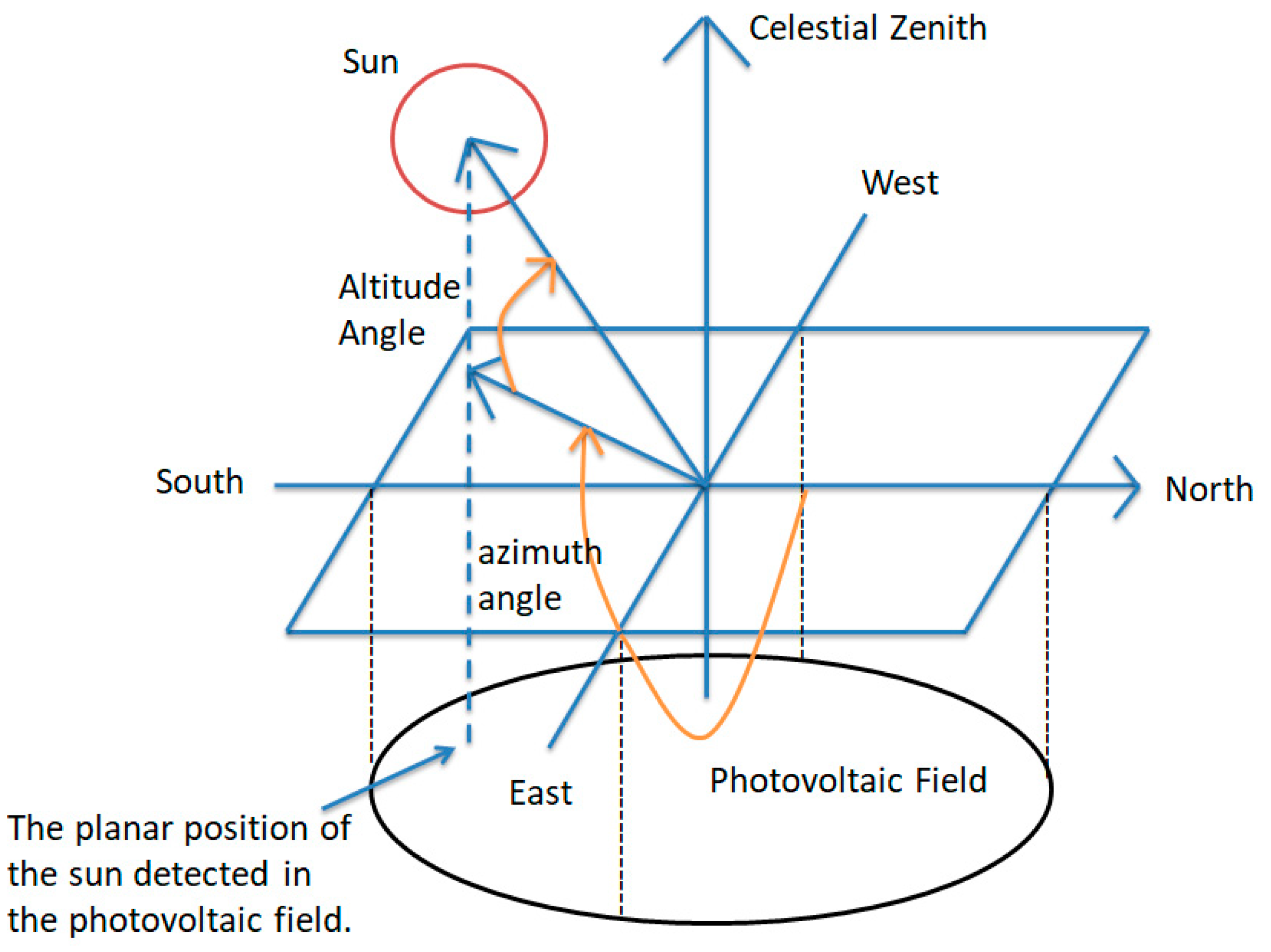
In ultra-short-term power forecasting for PV power stations based on sky imagers, the solar azimuth angle and elevation angle are critical parameters that influence prediction accuracy [15,16,17,18]. These angles describe the precise position of the sun relative to the sky imager and the PV panels [19], as illustrated in Figure 1, directly affecting the distribution and reception efficiency of solar radiation on the panels [20]. Accurate calculation of these angles requires the integration of factors such as the geographic coordinates of the PV station, time, and date. Furthermore, these parameters play an essential role in constructing solar occlusion models, providing crucial input data for subsequent power prediction processes.
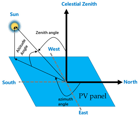
Figure 1.
Schematic diagram of the sun’s position.
Calculation of solar altitude and azimuth angles [21]:
- (1)
- The solar altitude angle is calculated using the following equation:where represents the latitude of the photovoltaic site, is the solar declination angle, and is the solar hour angle.
- (2)
- Calculation of the solar azimuth angle
- (i)
- When , the solar azimuth angle is calculated using the following equation:
- (ii)
- When , the solar azimuth angle is calculated as follows:
2.2. Determination of Solar Occlusion Area Using Sky Imager Images
The solar elevation and azimuth angles determine the cloud regions that may obstruct solar radiation reaching the PV power station, as illustrated in Figure 2. To accurately identify potential shading regions caused by clouds, it is necessary to calculate these areas based on the viewing angle of the sky imager and the position of the sun [22,23]. The images captured by the sky imager can be geometrically projected onto the PV station to map the shading regions.
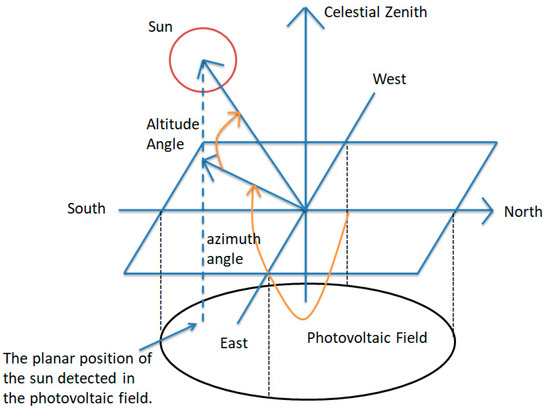
Figure 2.
Relationship between solar angles and the PV power station.
Given the relative position of the sky imager and the PV station, the perspective projection formula is employed to map points from the image into the actual three-dimensional space [24]:
where are the coordinates of the image center, is the focal length, and represents the distance between the sky imager and the PV station.
3. Proposed Methodology
3.1. Specific Steps of the Implementation Method
This study proposes a short-term PV power forecasting model based on maximum composite reflectivity (MCR) and sky imager data, aiming to improve forecasting accuracy under complex weather conditions by precisely estimating cloud coverage in shaded regions. MCR, which represents the highest radar reflectivity value from multiple radar scans, is particularly useful for correcting power forecasts during weather changes such as rainfall or meteorological transitions. By integrating MCR with sky imager data, this approach enhances the model’s ability to capture dynamic weather events that impact PV power generation. The technical workflow, as illustrated in Figure 3, involves the key steps outlined below.
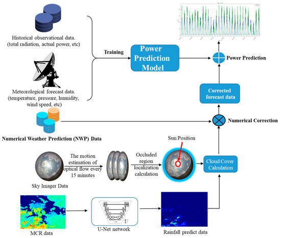
Figure 3.
A PV power forecasting model integrating radar data and sky imager data.
The process consists of five major modules: data collection, image processing, data fusion, power prediction model construction, and result correction.
First, real-time cloud images are collected using a sky imager, supplemented by ground-based and spaceborne imaging equipment to monitor the target area from multiple perspectives. High-resolution cloud data are acquired and preprocessed. Temporal overlay techniques are then applied to compute critical cloud characteristics, such as coverage, movement direction, and velocity. These processed image data are further integrated with meteorological satellite observations and meteorological radar reflectivity. Specifically, a spatiotemporal multi-source data matching framework is employed to merge the sky imager’s image data with cloud coverage information obtained from meteorological satellites, ensuring temporal consistency and spatial alignment between the two datasets. Simultaneously, meteorological radar reflectivity data are downscaled to enhance resolution and filtered to remove non-precipitation echo noise, improving data quality. Finally, through a unified coordinate projection framework, these datasets are integrated into a unified cloud coverage map, which serves as an input to the subsequent photovoltaic power forecasting model for correction and optimization under dynamic weather conditions.
During the data fusion phase, the segmented cloud images and coverage areas are analyzed to compute cloud motion trajectories over specific time periods. This information is used to predict solar obstruction on PV panels at different times. The system also considers the geographical location, azimuth angle, and solar elevation angle of the PV station to construct a multivariable power forecasting model. The model uses cloud parameters and solar radiation characteristics as input variables, combined with historical power data, to generate short-term PV power forecasts.
Finally, a result correction module refines the forecast outputs by comparing them with actual observations. This module analyzes the differences between the forecast results and actual observations using an error minimization algorithm to calculate dynamic correction factors. These factors are then applied to adjust the prediction bias, ensuring improved forecast accuracy. The corrected power prediction data provide more precise results, supporting grid dispatching decisions and optimizing PV station operations. To achieve real-time adjustments, this correction process operates cyclically, where new observations continuously feed into the module to update the correction factors. This ensures that the prediction data remain both accurate and timely, meeting the stringent requirements for managing power fluctuations in renewable energy stations.
3.2. Key Issues Discussion
During the implementation of the proposed methodology, several critical issues must be addressed. These challenges not only directly impact the prediction accuracy of the model but also influence the reliability and validity of the entire research.
3.2.1. Determining the Relative Positions of the Sun, Sky Imager, and PV Station
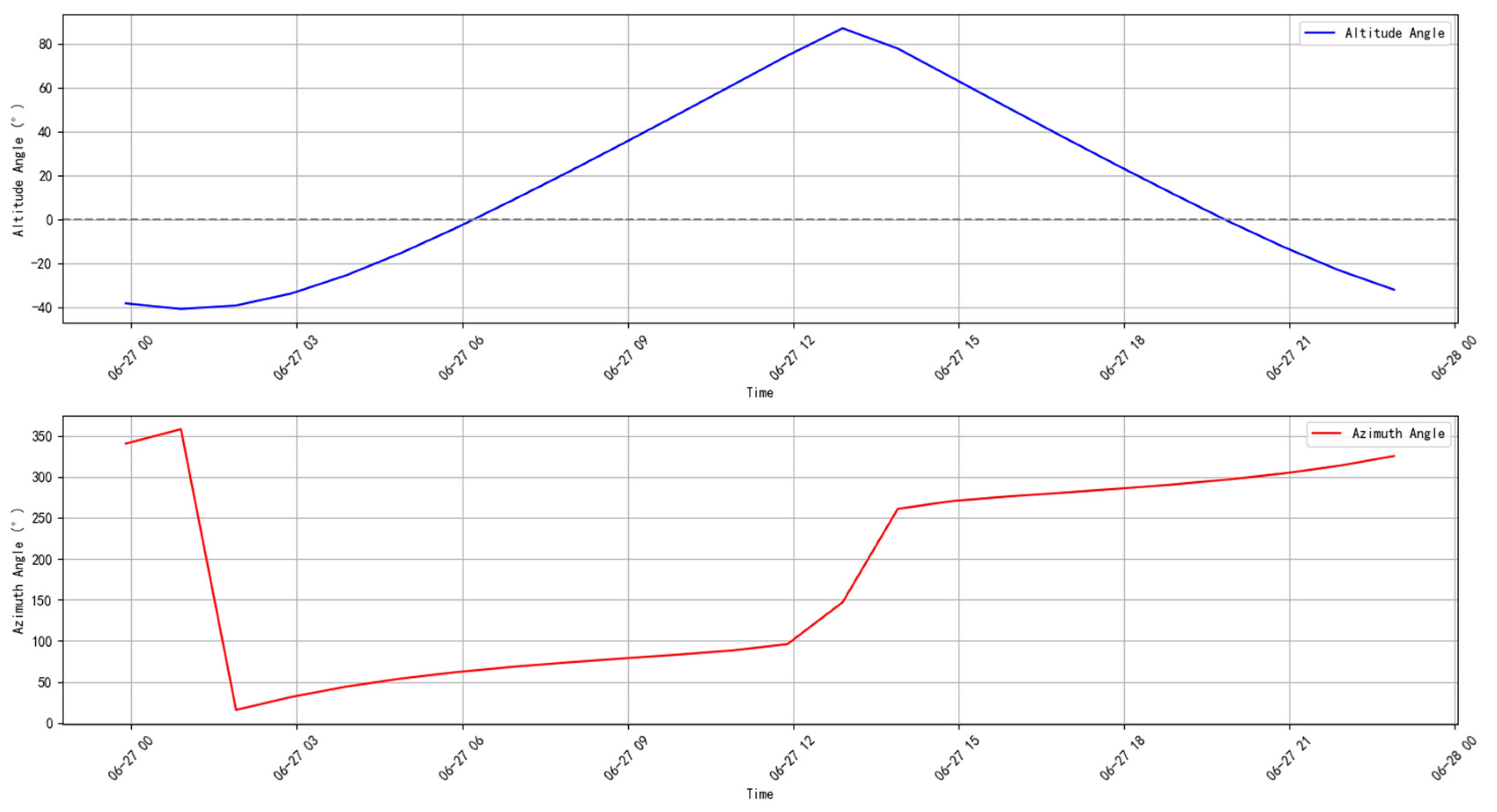
Accurately determining the relative positions of the sun, sky imager, and PV station forms the foundation of the model. High-precision GPS systems are used to obtain the geographic coordinates and elevation data for the PV station and the sky imager. For a given timestamp, the solar altitude and azimuth angles can be calculated using Equations (1)–(3) (as shown in Figure 4). These parameters are essential for subsequent shading area calculations. To ensure the representativeness of observational data, the sky imager should be installed near the PV station to capture cloud dynamics affecting solar energy generation.

Figure 4.
Variations in solar altitude and azimuth angles in Guizhou on 27 June 2024.
Real-time updates of the sun’s position are crucial for accurately calculating the shading area due to the dynamic changes in solar and cloud positions. Using the aforementioned solar position formulas, the solar altitude and azimuth angles can be dynamically obtained, which are critical for estimating the shading area. The shaded cloud fraction can be calculated using the following formula:
where represents the shaded cloud fraction, is the cloud height, is the angle between the cloud and the sun, and is the sun’s height. This formula enables precise estimation of the shading effect of clouds on solar radiation under dynamic conditions, thereby improving the reliability of power prediction.
3.2.2. Influence of Radar Data and Rainfall Changes on Power Prediction
Meteorological radar data play a vital role in capturing changes in rain-bearing cloud layers. Particularly under severe convective weather, radar data can track real-time rainfall variations. These rainfall changes directly affect solar radiation levels and subsequently impact power output. Incorporating radar data to predict future rainfall variations and correcting numerical forecasts can more accurately capture radiation changes.
Currently, various algorithms are available for rainfall estimation, such as the UNet-GRU-based method proposed in [25] and the DAM-EfficientNet approach discussed in [26]. These methods provide feasible solutions to enhance the adaptability and accuracy of photovoltaic power forecasting models.
3.3. Model Performance Evaluation
When evaluating the performance of ultra-short-term power prediction models for PV stations, various metrics are typically used to assess the model’s accuracy and goodness of fit. Below are several commonly used evaluation metrics, along with their calculation formulas and significance:
- (1)
- MSE
The mean squared error (MSE) measures the average squared difference between the predicted values and the actual observed values. It reflects the degree of deviation between the predicted and actual values. A smaller MSE indicates that the model’s predictions are closer to the actual values. The formula for calculating MSE is as follows:
where is the actual observed value, is the predicted value, and is the total number of data points. The mean squared error (MSE) amplifies larger errors by squaring the residuals, thus giving more weight to larger deviations in the evaluation, making the model more sensitive to large errors.
- (2)
The coefficient of determination () is a metric that measures the degree of fit of the model to the data, emphasizing the model’s ability to explain the overall trend of the observed data. Its value ranges from 0 to 1, where an value closer to 1 indicates a better fit of the model to the data. To enhance the evaluation of long-term trends in photovoltaic power forecasting, a time-weighted adjustment is introduced into the formula to account for the significance of specific periods, such as sunrise and sunset. The adjusted formula for is as follows:
where is the mean of the observed values, and , with β > 0 representing the trend weight. The weighting factor assigns higher significance to periods with larger variations in power, ensuring that the model’s ability to fit critical time intervals is accurately evaluated.
- (3)
- Theil’s U Statistic
Theil’s U statistic is a dimensionless metric used to quantify the relative error of predictions, measuring the proportion of error between the predicted and actual values. Its value ranges from 0 to 1, with a value closer to 0 indicating higher prediction accuracy of the model. The formula is as follows:
Theil’s U statistic has robust relative error evaluation capabilities, making it particularly suitable for datasets with significant fluctuations. This metric can effectively aid in understanding a model’s capability to capture data variability.
- (4)
- NSE
The Nash–Sutcliffe efficiency (NSE) assesses the goodness of fit between model predictions and observed values relative to the mean of the observations. To highlight the model’s ability to capture dynamic variations in photovoltaic power forecasting, an additional term is introduced to evaluate the prediction accuracy of power change rates. The adjusted formula for NSE is as follows:
where and represent the observed and predicted rates of change, respectively, and γ > 0 controls the weight of the change rate term. This adjustment enhances NSE’s sensitivity to dynamic variations, making it a more comprehensive metric for evaluating short-term fluctuations in photovoltaic power.
The four metrics discussed above, when used in combination, offer a comprehensive evaluation of the performance of ultra-short-term photovoltaic power forecasting models. Specifically, MSE and assess model performance in terms of absolute error and goodness of fit, respectively, while Theil’s U and NSE provide complementary evaluations based on relative error and trend fitting. Theil’s U is particularly suitable for this study as it handles data with volatility and extreme values more effectively compared to other commonly used relative error metrics such as the mean absolute percentage error (MAPE). Unlike MAPE, which is highly sensitive to small values and can lead to large errors when dealing with extreme values, Theil’s U offers better stability and is less influenced by outliers. Therefore, Theil’s U was chosen in this study due to its robustness in capturing fluctuations in photovoltaic power data. This multi-metric approach allows for a more holistic understanding of the model’s predictive accuracy and its stability across different conditions.
3.4. Evaluation Criteria for Ultra-Short-Term Forecasting Models
According to the “Implementation Rules for PV Power Grid Connection and Auxiliary Services Management in the Southern Region” proposed by China Southern Power Grid, the accuracy of ultra-short-term photovoltaic power forecasts is calculated based on the fourth-hour forecast results, with daily statistics and monthly assessments. The accuracy calculation algorithm is as follows:
where:
represents the available power at time during curtailment periods, and the actual power at time during non-curtailment periods.
represents the forecasted power for time , issued four hours in advance.
denotes the total installed capacity of the PV power station for the current month.
The fourth-hour forecast accuracy for ultra-short-term power predictions at PV power stations should not fall below 70%. For each percentage point decrease below this threshold (fractions of a percentage are rounded up to one percentage point), the assessment will be conducted at a penalty rate based on the product of the monthly installed capacity, a factor of 1, and A4 standards. Here, A4 is the correction coefficient for the mid-term power forecasting accuracy of PV systems, with a default value of 1.
4. Experimental and Discussion
4.1. Experimental Setup
The experiment was conducted at a photovoltaic power station located in Guizhou Province, with an installed capacity of 200 MW. The region is characterized by diverse climatic conditions, with typically clear skies in the morning, increasing cloud cover around midday, and a return to clear skies in the evening. This region exhibits distinct microclimatic phenomena. To improve the accuracy of PV power forecasting, a sky imager was installed to monitor cloud dynamics in real time, and data from Doppler radar, specifically the MCR, were also incorporated. By integrating data from these instruments, we were able to capture cloud movement and its impact on solar irradiance, laying the foundation for the subsequent development of the power forecasting model. The data collection and processing stages employed advanced image processing and machine learning techniques to enable accurate power predictions under complex meteorological conditions. The dataset used for this study spans from 1 June 2024, to 8 July 2024, and the relevant data are presented in Table 1.

Table 1.
Experimental environment information.
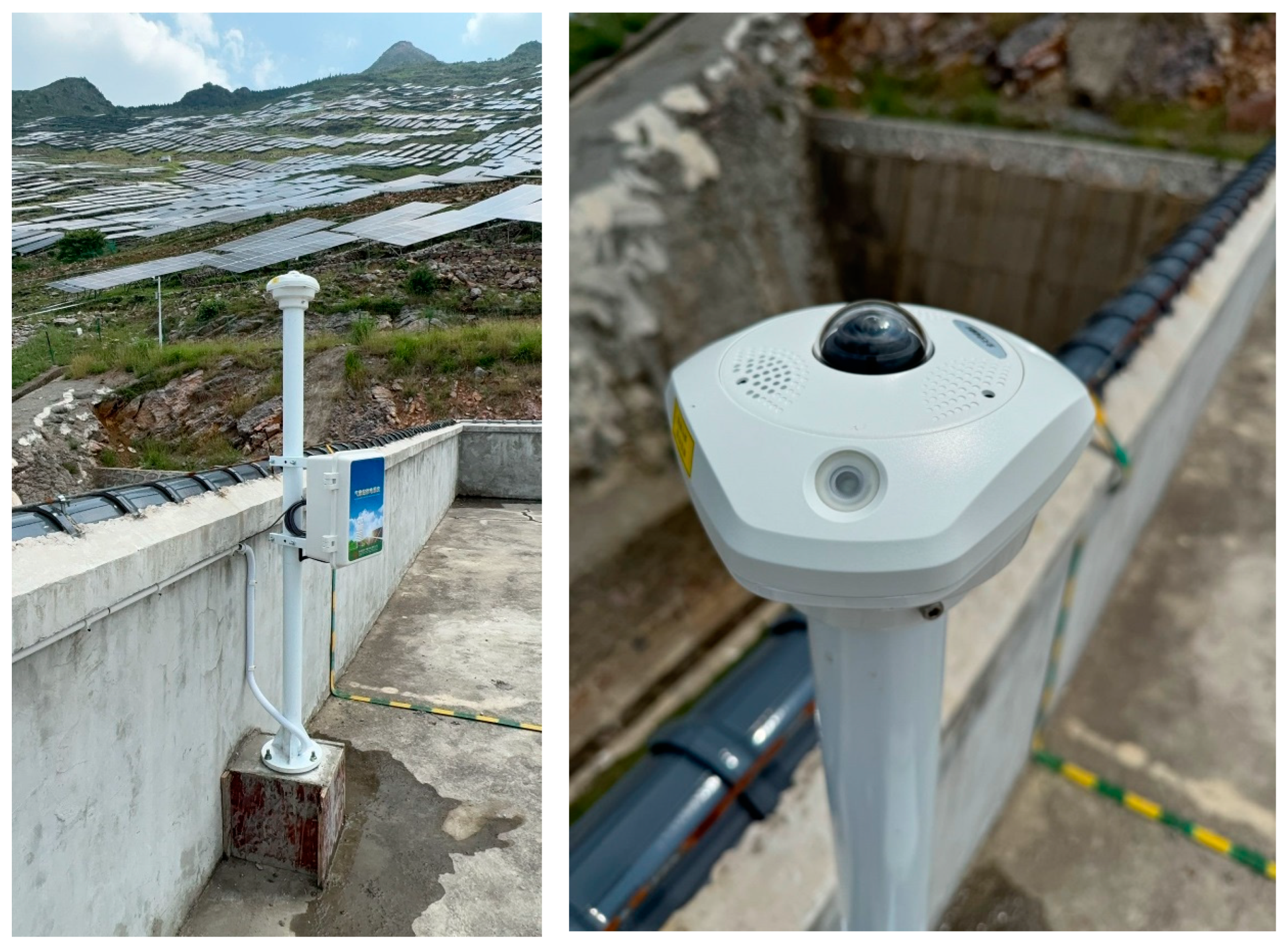
The TBK11 sky imager, produced by Jinzhou Sunshine Meteorological Technology Co., Ltd. in Jinzhou, Liaoning Province, China, has a cloud detection range of 0 to 10 km. It is equipped with a 180° ultra-wide-angle, high-resolution, full-color sensor, enabling fully automated, real-time monitoring of sky conditions throughout the day. Advanced image-based artificial intelligence (AI) recognition technology and a high-speed computational model for cloud detection enable the system to calculate cloud coverage information rapidly and accurately. This information is subsequently utilized for photovoltaic power generation forecasting and solar irradiance assessment. For detailed technical parameters of the TBK11, please refer to Table 2. The specific installation location is illustrated in Figure 5.
Table 2.
Technical Parameters of TBK11.

Figure 5.
Installation location of the sky imager.
4.2. Experimental Results
4.2.1. Impact of MCR Data on the Accuracy of Ultra-Short-Term Power Forecasting
In the ultra-short-term power forecasting process, predictive models are typically developed using parameters such as time, historical observed irradiance, forecasted irradiance, and historical observed power to estimate future power generation. Therefore, the accuracy of irradiance forecasts has a substantial impact on the precision of power predictions. Prior to integrating sky imager and meteorological radar data, the constructed model was applied to evaluate the accuracy of ultra-short-term power forecasts. Various assessment metrics were employed to analyze predictions for the period from 1 July to 8 July. The results are summarized in Table 3.
Table 3.
Evaluation metrics for ultra-short-term power forecasting without using sky imager and radar data (1 July 2024–8 July 2024).
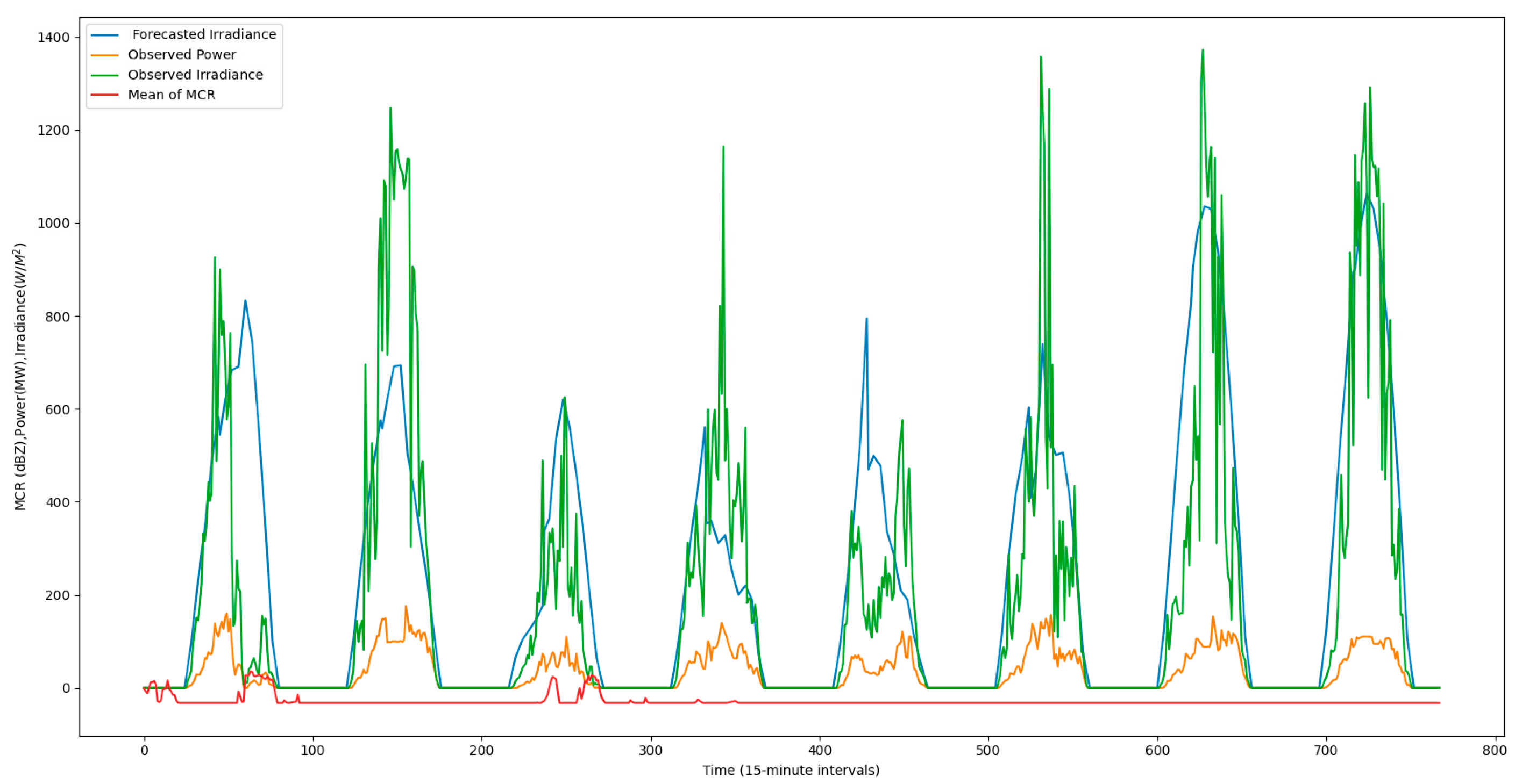
The forecast model’s performance on 1 July and 3 July was notably poor. By analyzing the MCR, numerical forecast data, observed irradiance, and actual power (as shown in Figure 6), we observed rain events on these two days. The MCR clearly indicated these events, but the numerical forecast data was not appropriately adjusted, leading to inaccurate forecasts. Therefore, improving forecast accuracy necessitates correcting the numerical forecast data.
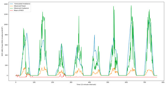
Figure 6.
Comparison of forecasted irradiance, observed irradiance, mean of MCR, and actual power output.
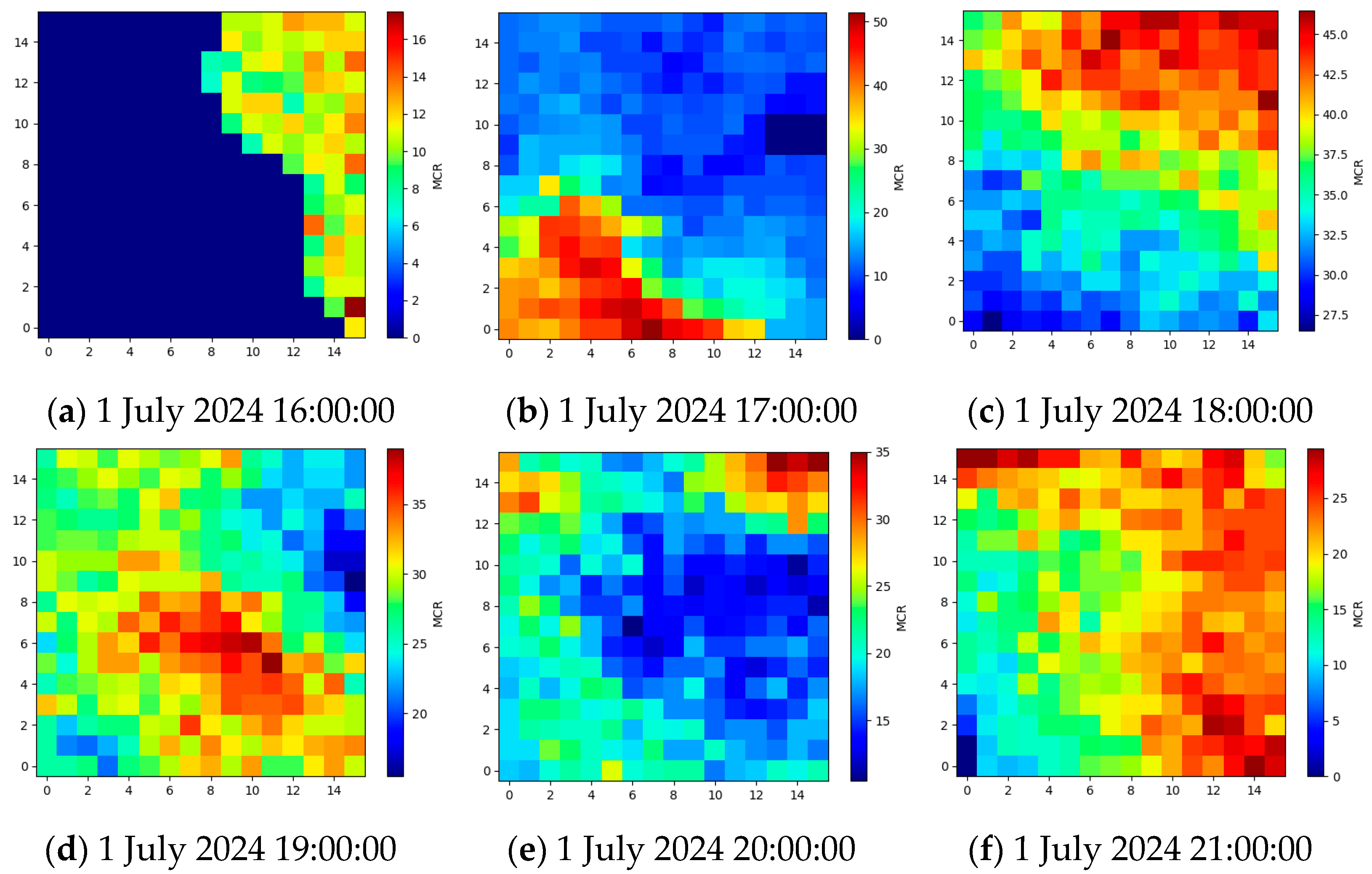
Using radar data images, we can clearly observe the precipitation event (as shown in Figure 7). This precipitation forecast process can be predicted using models such as UNET-GRU, as introduced earlier. For example, inputting the first 16 MCR images can help predict the future changes in the MCR cloud pattern.
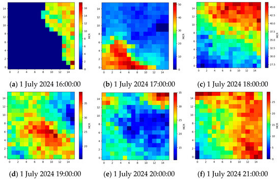
Figure 7.
A precipitation event displayed by MCR data (1 July 2024).
From the figure, it is evident that the numerical forecasts were accurate in the morning, as the weather was clear. However, starting at 16:00 in the afternoon, the predicted values deviated significantly from the actual values due to the occurrence of rainfall. This deviation in the forecast data was caused by the onset of rainfall, highlighting the importance of accurately predicting rainclouds to ensure reliable numerical forecasts.
4.2.2. Estimation of Partial Cloud Coverage in the Sun’s Position
The sky imager captures cloud information within a 10 km radius; however, only the cloud coverage near the sun significantly affects the actual irradiance at the photovoltaic station. This impact can be validated through the following experimental process. First, images captured by the sky imager are processed to delineate the imager’s field of view, extract the sky region, and finally identify the sun’s position within the image (Figure 8).
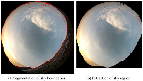
Figure 8.
Sky region extraction from sky imager.
Once the sky region is extracted, the next step is to determine the sun’s position within the image. By utilizing geographic coordinates, altitude, and time, the sunrise and sunset times in the study area from June to July (7:00 to 19:00) are calculated. Due to incomplete parameters, an interactive approach is employed to manually identify the sun’s position at different times of the day within the images. The identified positions are then fitted to generate the sun’s trajectory (Figure 9). As shown in the figure, the green circle represents the area covered by the solar shadow.
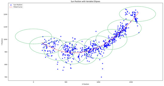
Figure 9.
Trajectory of the sun on the sky imager.
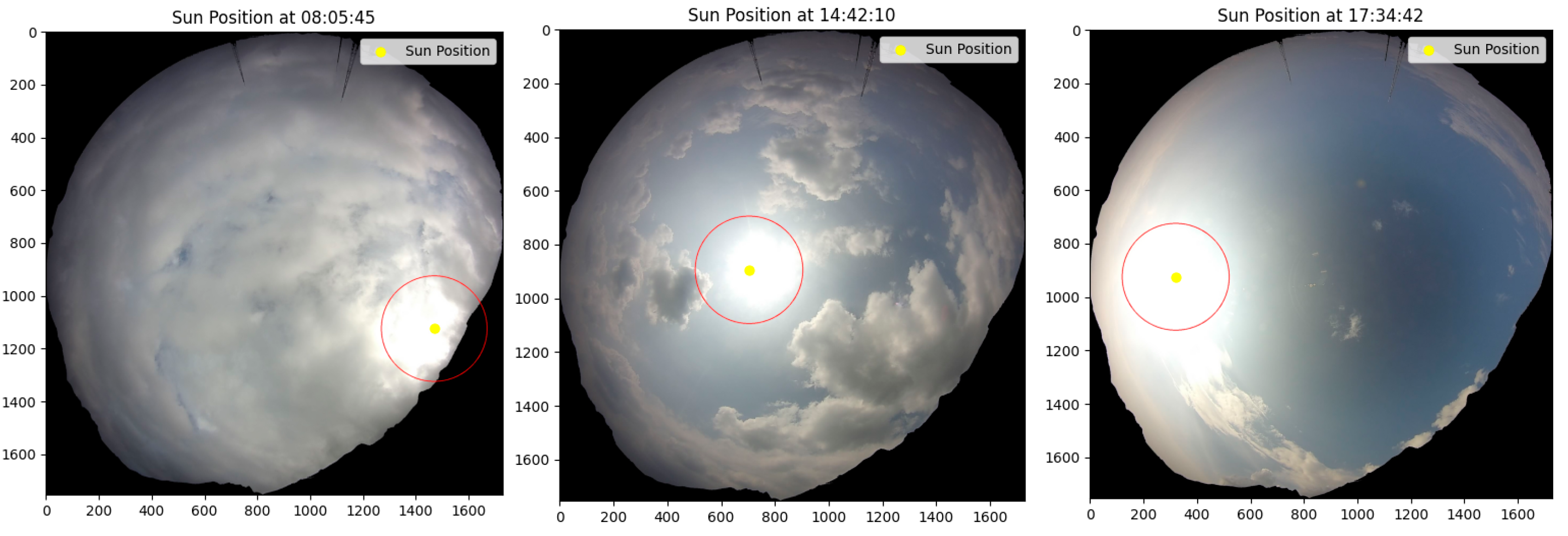
Using Equations (1)–(3), it is established that the sun appears on the right (east) side of the image in the morning and shifts to the left (west) side by evening. Based on the fitted curve, the sun’s position at any given time is determined, and the corresponding key region (red circle) centered around the sun is extracted (Figure 10).

Figure 10.
Positions of the sun in captured images at different times.
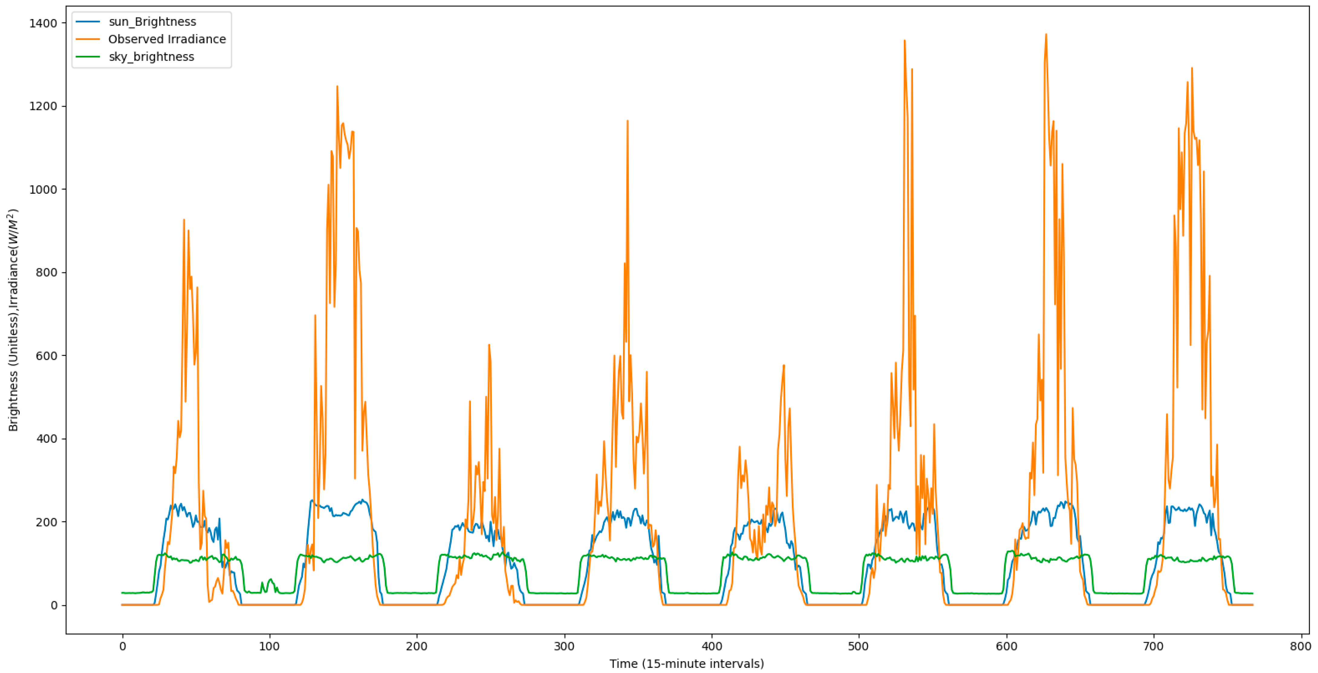
A comparison of the brightness information from the extracted occluded region and the global sky brightness shows that the brightness near the sun’s position has a more significant influence on irradiance. As observed in Figure 11, the brightness of the sun’s region strongly correlates with observed irradiance, while the global brightness information is primarily aligned with the day–night cycle. The changes in global brightness during daylight hours show limited sensitivity to irradiance variations.
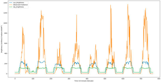
Figure 11.
Relationships between cloud cover data (global sky and sun-centric) and observed irradiance (1 July–8 July 2024).
As discussed in the previous section, MCR data is a critical factor affecting observed irradiance and power output. To determine whether total sky cloud coverage or cloud coverage in the sun’s region should be used as a feature, the following experiment was conducted. We employed two machine learning models, random forest and XGBoost (Version 2.1.1) [27,28,29], to evaluate their correlation and consistency with observed irradiance. The performance was assessed using metrics such as MSE, , Theil’s U, and NSE.
The results, summarized in Table 4, indicate that the cloud coverage in the sun’s region significantly impacts observed irradiance and power output, yielding better performance across all metrics compared to global sky cloud coverage. This finding underscores the importance of focusing on localized cloud coverage near the sun’s position as a best practice for photovoltaic power forecasting. The localized cloud coverage was determined by segmenting the region around the sun in sky imager data based on azimuth and elevation angles. This segmentation was dynamically adjusted throughout the day to follow the sun’s movement. Once determined, this localized cloud coverage was integrated into the forecasting model as a key feature, enhancing its ability to capture irradiance and power fluctuations caused by cloud movement. This approach not only improved the model’s sensitivity to localized weather variations but also resulted in higher overall predictive accuracy under dynamic atmospheric conditions.
Table 4.
Validation of correlations and consistencies among different input-output features.
4.2.3. Correction of NWP Data and Performance Evaluation of the Power Prediction Model
The previous experiments revealed that the accuracy of NWP data significantly affects the precision of power predictions. However, the NWP data can sometimes deviate from actual observations, necessitating corrective measures. To address this, we developed a UNET-based prediction model utilizing sky imager images and MCR data. The model’s input comprises 16 sequential images from the preceding 4 h, and its output is a forecasted image for the next time step. The forecasted image is then processed to extract relevant regions and determine the sun’s occlusion area.
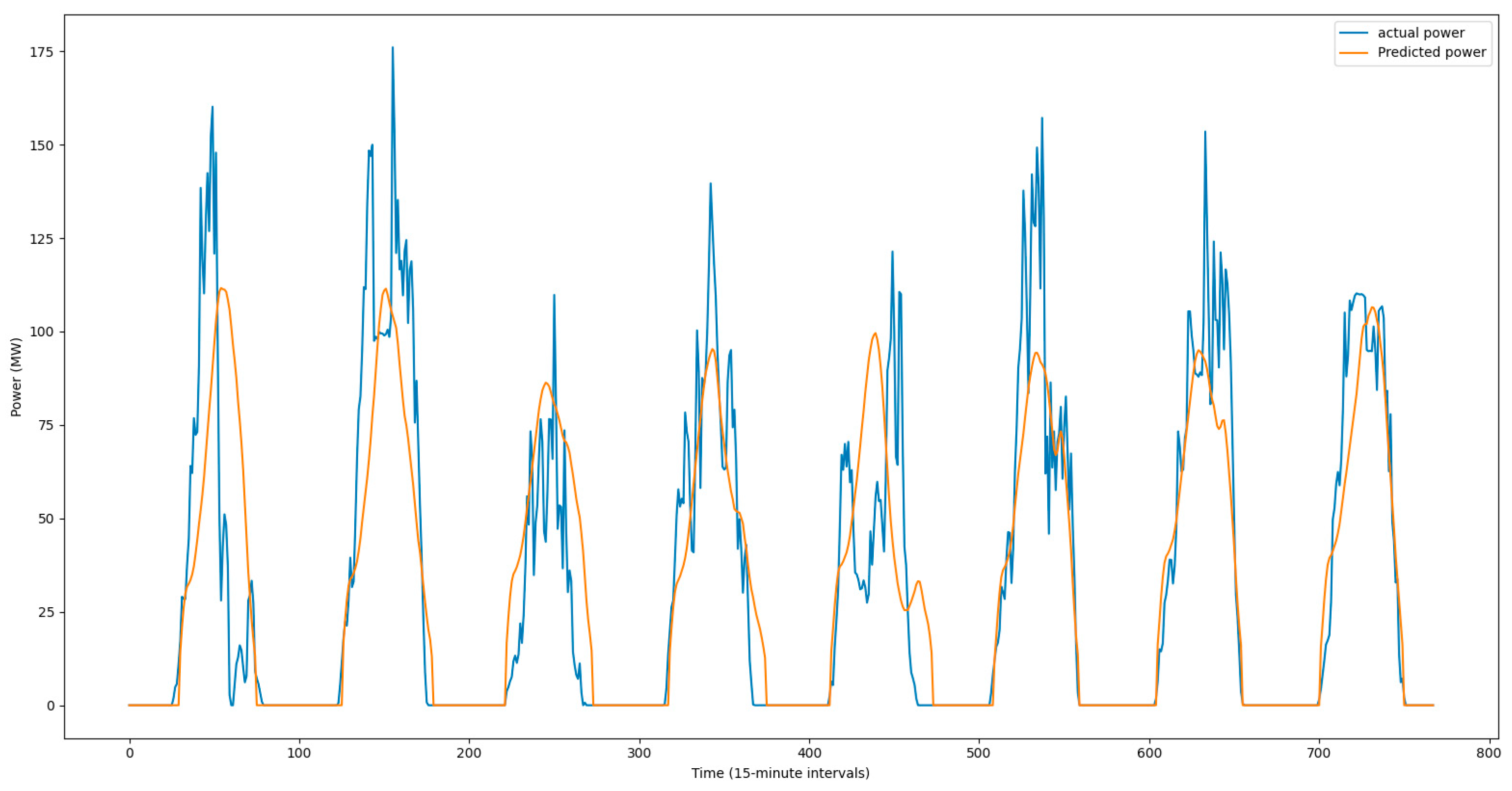
Using a pre-trained machine learning model, which incorporates MCR data, sun position information, and cloud occlusion features, corrections are applied to the NWP data. Subsequently, the corrected NWP data are utilized to re-predict power output. The results, shown in Figure 12, demonstrate the enhanced accuracy of the corrected forecasts.

Figure 12.
Comparison of actual and predicted power output.
After applying the corrected NWP data, the performance of the power prediction model was re-evaluated. Key metrics are summarized in Table 5. A comparison of the results, particularly for 1 July and 3 July, indicates a substantial improvement in forecast accuracy. These findings validate the effectiveness of integrating sky imager and radar data for improving NWP-based predictions.
Table 5.
Evaluation metrics for ultra-short-term power forecasting using sky imager and radar data (1 July–8 July 2024).
By comparing Table 3 and Table 5, it can be observed that the average forecasting accuracy over eight days increased from 67.26% to 77.47%, representing an improvement of 15%. This enhancement is primarily attributed to the correction of NWP data using MCR data. Notably, the forecasting accuracy on 1 July and 3 July showed significant improvements. Furthermore, the integration of sky imager data also contributed to enhanced accuracy under clear weather conditions. Specifically, the evaluation metrics indicate that the MSE decreased from 481.5 to 292.6, the increased from 0.724 to 0.855, the NSE increased from 0.725 to 0.851, and Theil’s U coefficient reduced from 0.42 to 0.32. These findings demonstrate that combining sky imager and meteorological radar data is an effective approach to improving the accuracy and robustness of ultra-short-term photovoltaic power forecasting models.
5. Conclusions and Future Work
This study developed an ultra-short-term PV power forecasting model that integrates sky imager and meteorological radar data to enhance forecasting accuracy. The model dynamically tracks cloud movement and estimates cloud coverage, resulting in a significant 15% improvement in the forecasting accuracy over an 8-day period. Specifically, the mean squared error (MSE) was reduced by 39.2%, and the coefficient of determination () increased from 0.724 to 0.855. The Nash–Sutcliffe efficiency (NSE) improved from 0.725 to 0.851, while Theil’s U decreased from 0.42 to 0.32. These findings demonstrate the model’s strong performance under dynamic weather conditions, especially during abrupt weather transitions, such as those observed on 1 July and 3 July. This integrated approach lays a solid foundation for advancing ultra-short-term PV power forecasting. Future research will explore the use of constant altitude plan position indicator (CAPPI) data from Doppler radar for three-dimensional cloud modeling and will aim to validate the model across diverse regions to ensure its adaptability and practical application in PV power forecasting.
Author Contributions
Conceptualization, C.Y.; data curation, R.G. and X.X.; formal analysis, R.L. and C.Y.; funding acquisition, W.W.; investigation, P.W., R.G. and X.X.; methodology, R.L., W.W. and C.Y.; project administration, W.W.; software, P.W., Y.W. and X.X.; supervision, C.Y. and W.W.; writing—original draft, W.W. and R.L.; writing—review and editing, R.L. All authors have read and agreed to the published version of the manuscript.
Funding
This research was funded by China Huadian Corporation’s 2023 Science and Technology Project (CHDKJ23-02-40): “Research and Application of Meteorological Empowerment for Photovoltaic Power Plant Safety and Efficient Warning and Prediction Technology”, and Guizhou Meteorological Science and Technology Cooperation Project TD [2024]04: “Research on Wind and Solar Power Forecasting Technology”.
Data Availability Statement
The data used to support the findings of this study are available from the corresponding author upon request.
Conflicts of Interest
Author Weixiong Wu, Rui Gao and Peng Wu were employed by the Mamaya Photovoltaic Branch of Guizhou Beipanjiang Electric Power Co., Ltd. Author Chen Yuan and Xiaoling Xia were employed by the Guizhou New Meteorological Technology Co., Ltd. The remaining authors declare that the research was conducted in the absence of any commercial or financial relationships that could be construed as a potential conflict of interest.
References
- Khan, F.; Alshahrani, T.; Fareed, I.; Kim, J.H. A comprehensive degradation assessment of silicon photovoltaic modules installed on a concrete base under hot and low-humidity environments: Building applications. Sustain. Energy Technol. Assessments 2022, 52, 102314. [Google Scholar] [CrossRef]
- Feng, C.; Shao, L.; Wang, J.; Zhang, Y.; Wen, F. Short-term Load Forecasting of Distribution Transformer Supply Zones Based on Federated Model-Agnostic Meta Learning. IEEE Trans. Power Syst. 2024, 1–13. [Google Scholar] [CrossRef]
- Zhu, N.; Wang, Y.; Yuan, K.; Yan, J.; Li, Y.; Zhang, K. GGNet: A novel graph structure for power forecasting in renewable power plants considering temporal lead-lag correlations. Appl. Energy 2024, 364, 123194. [Google Scholar] [CrossRef]
- Kuo, W.-C.; Chen, C.-H.; Chen, S.-Y.; Wang, C.-C. Deep Learning neural networks for short-term PV power forecasting via sky image method. Energies 2022, 15, 4779. [Google Scholar] [CrossRef]
- Trigo-González, M.; Cortés-Carmona, M.; Marzo, A.; Alonso-Montesinos, J.; Martínez-Durbán, M.; López, G.; Portillo, C.; Batlles, F.J. Photovoltaic power electricity generation nowcasting combining sky camera images and learning supervised algorithms in the Southern Spain. Renew. Energy 2023, 206, 251–262. [Google Scholar] [CrossRef]
- Sun, S.; Ernst, J.; Sapkota, A.; Ritzhaupt-Kleissl, E.; Wiles, J.; Bamberger, J.; Chen, T. Short term cloud coverage prediction using ground based all sky imager. In Proceedings of the 2014 IEEE International Conference on Smart Grid Communications (SmartGridComm), Venice, Italy, 3–6 November 2014; IEEE: New York, NY, USA, 2014; pp. 121–126. [Google Scholar]
- Barbieri, F.; Rajakaruna, S.; Ghosh, A. Very short-term photovoltaic power forecasting with cloud modeling: A review. Renew. Sustain. Energy Rev. 2017, 75, 242–263. [Google Scholar] [CrossRef]
- Park, S.; Kim, Y.; Ferrier, N.J.; Collis, S.M.; Sankaran, R.; Beckman, P.H. Prediction of solar irradiance and photovoltaic solar energy product based on cloud coverage estimation using machine learning methods. Atmosphere 2021, 12, 395. [Google Scholar] [CrossRef]
- Chu, T.-P.; Guo, J.-H.; Leu, Y.-G.; Chou, L.-F. Estimation of solar irradiance and solar power based on all-sky images. Sol. Energy 2023, 249, 495–506. [Google Scholar] [CrossRef]
- Kómar, L.; Kocifaj, M. Statistical cloud coverage as determined from sunshine duration: A model applicable in daylighting and solar energy forecasting. J. Atmos. Solar-Terrestrial Phys. 2016, 150–151, 1–8. [Google Scholar] [CrossRef]
- Gandoman, F.H.; Aleem, S.H.A.; Omar, N.; Ahmadi, A.; Alenezi, F.Q. Short-term solar power forecasting considering cloud coverage and ambient temperature variation effects. Renew. Energy 2018, 123, 793–805. [Google Scholar] [CrossRef]
- Peng, Z.; Yu, D.; Huang, D.; Heiser, J.; Yoo, S.; Kalb, P. 3D cloud detection and tracking system for solar forecast using multiple sky imagers. Sol. Energy 2015, 118, 496–519. [Google Scholar] [CrossRef]
- Falconi, M.T.; Marzano, F.S. Weather radar data processing and atmospheric applications: An overview of tools for monitoring clouds and detecting wind shear. IEEE Signal Process. Mag. 2019, 36, 85–97. [Google Scholar] [CrossRef]
- Xu, J.; Yoo, S.; Yu, D.; Huang, D.; Heiser, J.; Kalb, P. Solar irradiance forecasting using multi-layer cloud tracking and numerical weather prediction. In Proceedings of the 30th Annual ACM Symposium on Applied Computing, Salamanca, Spain, 13–17 April 2015; pp. 2225–2230. [Google Scholar]
- Guo, M.; Zang, H.; Gao, S.; Chen, T.; Xiao, J.; Cheng, L.; Wei, Z.; Sun, G. Optimal tilt angle and orientation of photovoltaic modules using HS algorithm in different climates of China. Appl. Sci. 2017, 7, 1028. [Google Scholar] [CrossRef]
- Reda, I.; Andreas, A. Solar position algorithm for solar radiation applications. Sol. Energy 2004, 76, 577–589. [Google Scholar] [CrossRef]
- Hafez, A.; Soliman, A.; El-Metwally, K.; Ismail, I. Tilt and azimuth angles in solar energy applications—A review. Renew. Sustain. Energy Rev. 2017, 77, 147–168. [Google Scholar] [CrossRef]
- Khan, T.M.Y.; Soudagar, M.E.M.; Kanchan, M.; Afzal, A.; Banapurmath, N.R.; Akram, N.; Mane, S.D.; Shahapurkar, K. Optimum location and influence of tilt angle on performance of solar PV panels. J. Therm. Anal. Calorim. 2020, 141, 511–532. [Google Scholar] [CrossRef]
- National Renewable Energy Laboratory (NREL). Solar Position and Intensity; NREL Technical Report; National Renewable Energy Laboratory (NREL): Golden, CO, USA, 2018. Available online: https://www.nrel.gov/research/re-solar.html (accessed on 5 November 2024).
- Grena, R. An algorithm for the computation of the solar position. Solar Energy 2008, 82, 462–470. [Google Scholar] [CrossRef]
- Mackay, M.E. Solar Energy: An Introduction; Oxford University Press: Oxford, MI, USA, 2015. [Google Scholar]
- Lothon, M.; Barnéoud, P.; Gabella, O.; Lohou, F.; Derrien, S.; Rondi, S.; Chiriaco, M.; Bastin, S.; Dupont, J.-C.; Haeffelin, M.; et al. ELIFAN, an algorithm for the estimation of cloud cover from sky imagers. Atmos. Meas. Tech. 2019, 12, 5519–5534. [Google Scholar] [CrossRef]
- Hussin, F.; Issabayeva, G.; Aroua, M.K. Solar photovoltaic applications: Opportunities and challenges. Rev. Chem. Eng. 2018, 34, 503–528. [Google Scholar] [CrossRef]
- SunEarthTools. Calculation of Sun’s Position in the Sky for Each Location on the Earth at Any Time of Day [EB/OL]. Available online: https://www.sunearthtools.com/dp/tools/pos_sun.php (accessed on 5 November 2024).
- Liu, R.; Zhou, H.; Li, D.; Zeng, L.; Xu, P. Evaluation of artificial precipitation enhancement using UNET-GRU algorithm for rainfall estimation. Water 2023, 15, 1585. [Google Scholar] [CrossRef]
- Liu, R.; Dai, H.; Chen, Y.; Zhu, H.; Wu, D.; Li, H.; Li, D.; Zhou, C. A study on the DAM-EfficientNet hail rapid identification algorithm based on FY-4A_AGRI. Sci. Rep. 2024, 14, 3505. [Google Scholar] [CrossRef]
- Li, W.; Cheng, C.; Xu, P.; Liu, R.; Zhang, Y.; Zhou, H. Short-Term Load Forecasting with TDCI: Temporal Decomposition and Channel Independence. In Proceedings of the 2023 7th International Conference on Electrical, Mechanical and Computer Engineering (ICEMCE), Xi’an, China, 20–22 October 2023; pp. 150–155. [Google Scholar]
- Abdou, F.A.M.; Memon, M.I. Comparative Analysis on Solar Energy Forecasting Using Random Forest, XGboost, ARIMA, and Different Neural Networks. In Proceedings of the 2023 Fourth International Conference on Smart Technologies in Computing, Electrical and Electronics (ICSTCEE), Bengaluru, India, 8–9 December 2023; pp. 1–6. [Google Scholar]
- Gao, H.; Qiu, S.; Fang, J.; Ma, N.; Wang, J.; Cheng, K.; Wang, H.; Zhu, Y.; Hu, D.; Liu, H.; et al. Short-term prediction of PV power based on combined modal decomposition and NARX-LSTM-Light GBM. Sustainability 2023, 15, 8266. [Google Scholar] [CrossRef]


Disclaimer/Publisher’s Note: The statements, opinions and data contained in all publications are solely those of the individual author(s) and contributor(s) and not of MDPI and/or the editor(s). MDPI and/or the editor(s) disclaim responsibility for any injury to people or property resulting from any ideas, methods, instructions or products referred to in the content. |
© 2024 by the authors. Licensee MDPI, Basel, Switzerland. This article is an open access article distributed under the terms and conditions of the Creative Commons Attribution (CC BY) license (https://creativecommons.org/licenses/by/4.0/).