Determining a Threshold to Delimit the Amazonian Forests from the Tree Canopy Cover 2000 GFC Data

 ,
,  ,
,  ,
,  and
and
Abstract
:1. Introduction
2. Materials and Methods
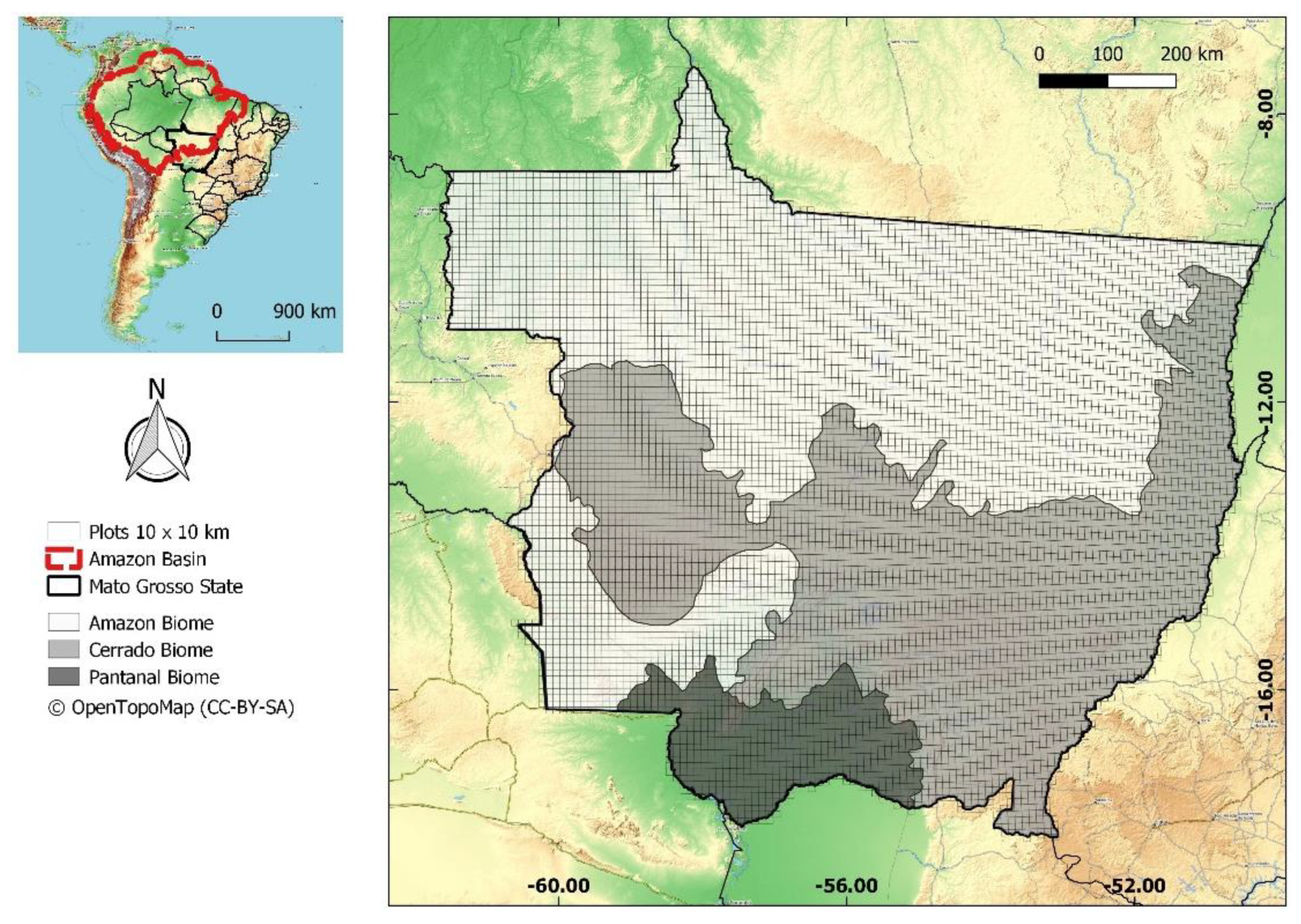
2.1. Study Area
2.2. Datasets
2.3. Methods
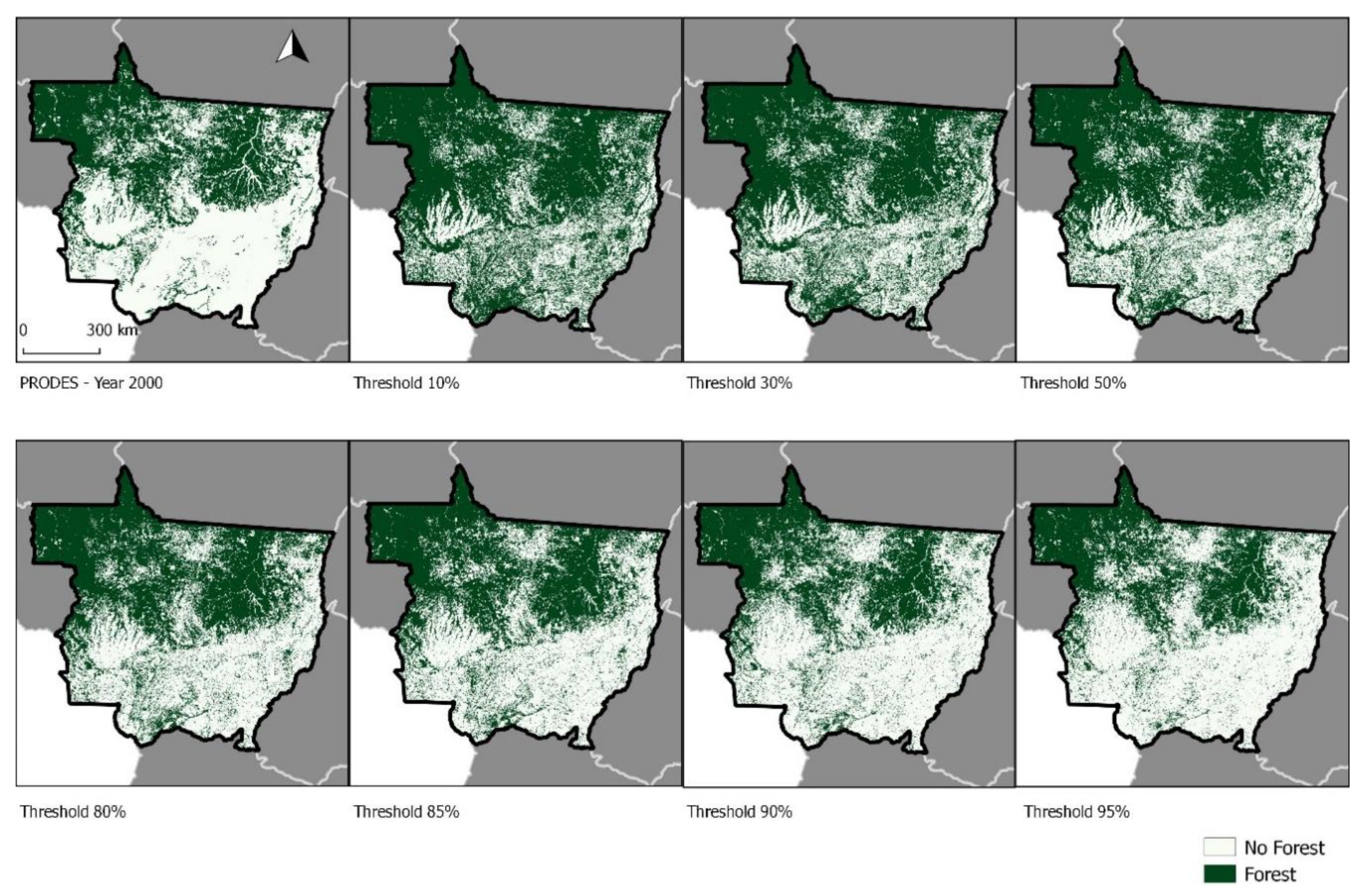
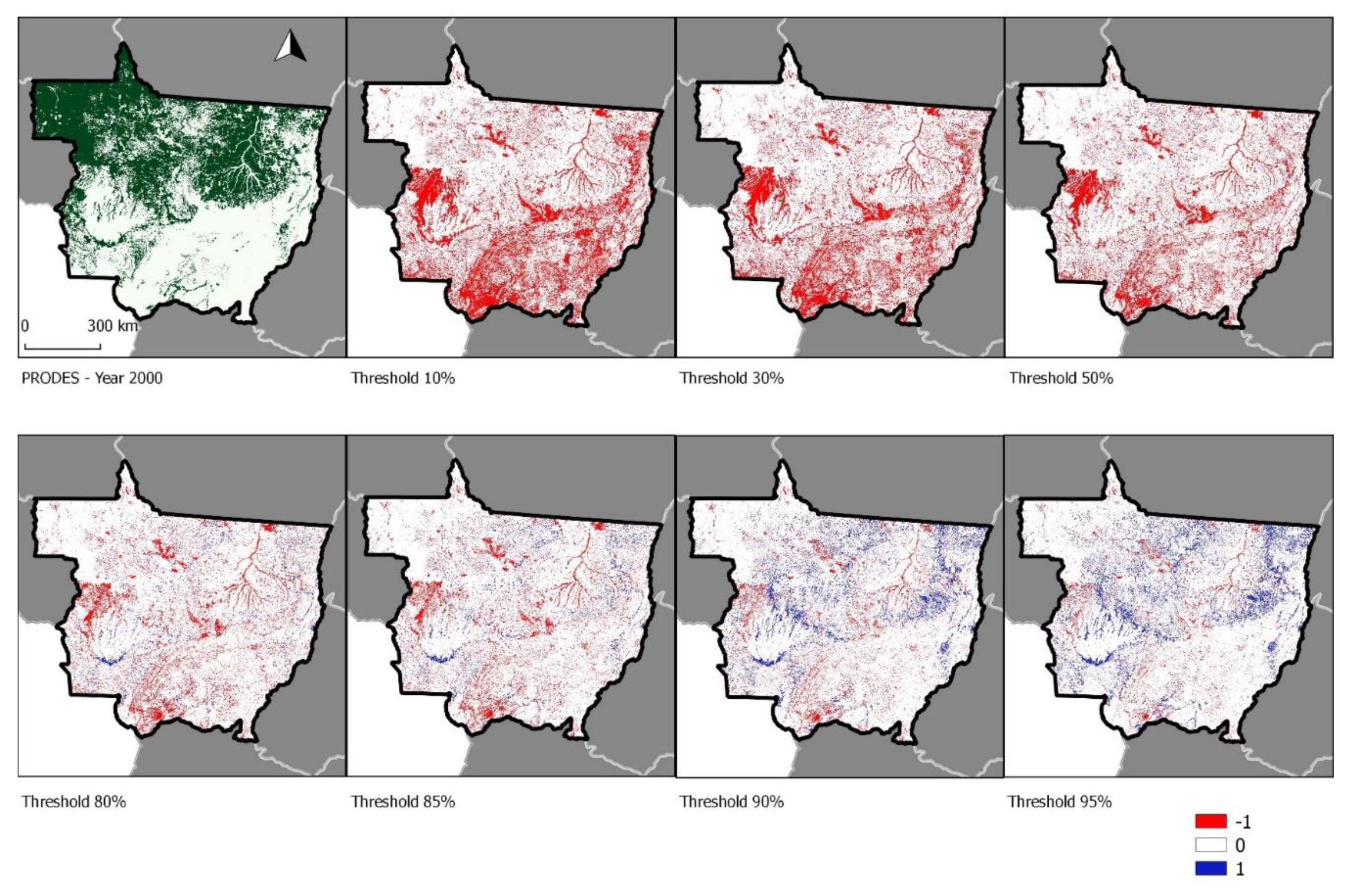
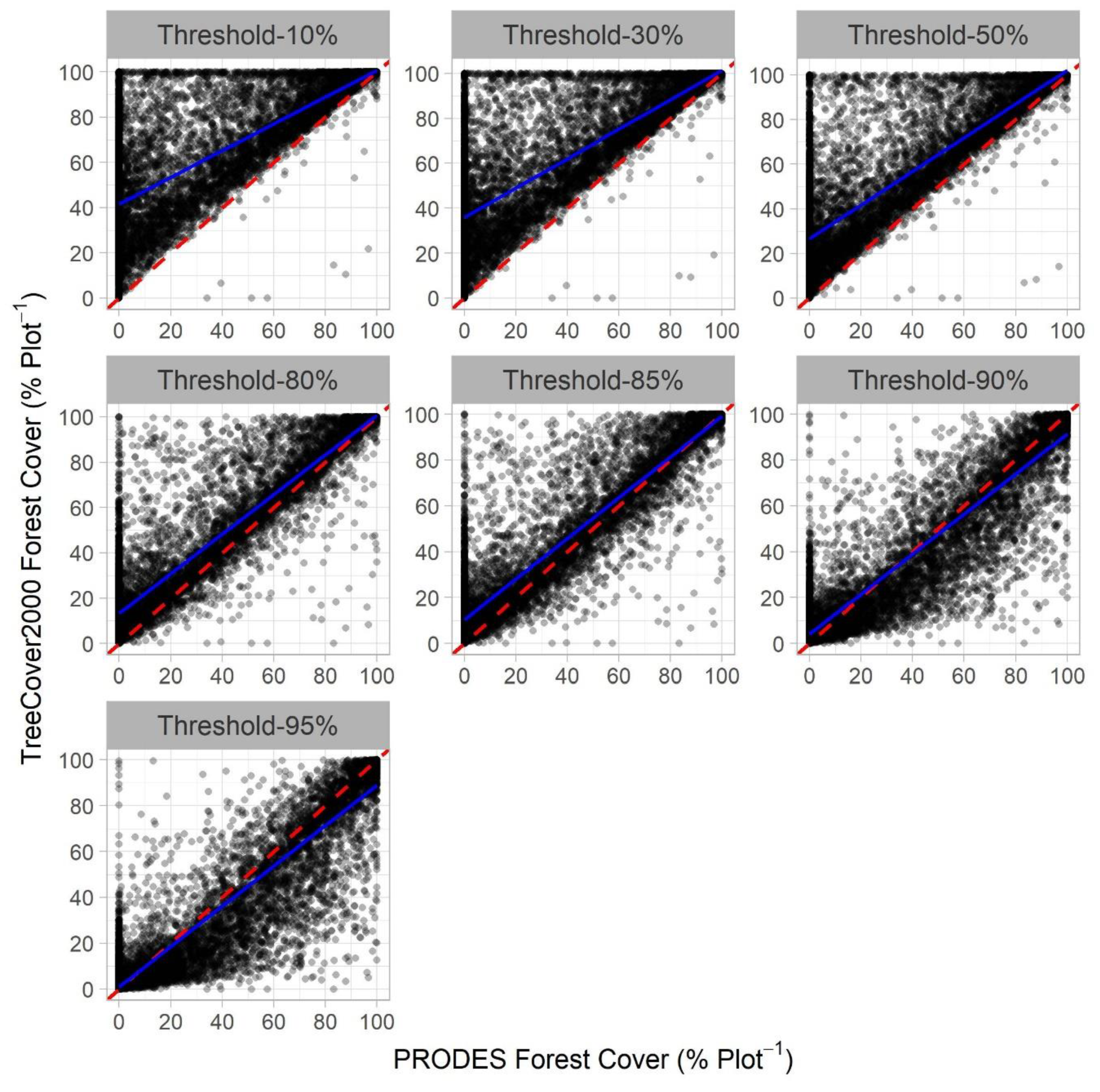
3. Results
4. Discussion and Conclusions
Author Contributions
Funding
Acknowledgments
Conflicts of Interest
References
- Le Quéré, C.; Raupach, M.R.; Canadell, J.G.; Marland, G.; Le Quéré, C.; Raupach, M.R.; Canadell, J.G.; Marland, G.; Bopp, L.; Ciais, P.; et al. Trends in the sources and sinks of carbon dioxide. Nat. Geosci. 2009, 2, 831–836. [Google Scholar] [CrossRef]
- van der Werf, G.R.; Morton, D.C.; DeFries, R.S.; Olivier, J.G.J.; Kasibhatla, P.S.; Jackson, R.B.; Collatz, G.J.; Randerson, J.T. CO2 emissions from forest loss. Nat. Geosci. 2009, 2, 737–738. [Google Scholar] [CrossRef]
- Houghton, R.A.; House, J.I.; Pongratz, J.; van der Werf, G.R.; DeFries, R.S.; Hansen, M.C.; Le Quéré, C.; Ramankutty, N. Carbon emissions from land use and land-cover change. Biogeosciences 2012, 9, 5125–5142. [Google Scholar] [CrossRef]
- Harris, N.L.; Brown, S.; Hagen, S.C.; Saatchi, S.S.; Petrova, S.; Salas, W.; Hansen, M.C.; Potapov, P.V.; Lotsch, A. Baseline Map of Carbon Emissions from Deforestation in Tropical Regions. Science 2012, 336, 1573–1576. [Google Scholar] [CrossRef] [PubMed]
- Baccini, A.; Goetz, S.J.; Walker, W.S.; Laporte, N.T.; Sun, M.; Sulla-Menashe, D.; Hackler, J.; Beck, P.S.A.; Dubayah, R.; Friedl, M.A.; et al. Estimated carbon dioxide emissions from tropical deforestation improved by carbon-density maps. Nat. Clim. Chang. 2012, 2, 182–185. [Google Scholar] [CrossRef]
- Aragão, L.E.O.C.; Anderson, L.O.; Fonseca, M.G.; Rosan, T.M.; Vedovato, L.B.; Wagner, F.H.; Silva, C.V.J.; Silva Junior, C.H.L.; Arai, E.; Aguiar, A.P.; et al. 21st Century drought-related fires counteract the decline of Amazon deforestation carbon emissions. Nat. Commun. 2018, 9, 536. [Google Scholar] [CrossRef]
- Monitoramento do Desmatamento da Floresta Amazônica Brasileira por Satélite. Available online: http://www.obt.inpe.br/OBT/assuntos/programas/amazonia/prodes (accessed on 1 January 2019).
- Aragão, L.E.O.C.; Poulter, B.; Barlow, J.B.; Anderson, L.O.; Malhi, Y.; Saatchi, S.; Phillips, O.L.; Gloor, E. Environmental change and the carbon balance of Amazonian forests. Biol. Rev. 2014, 89, 913–931. [Google Scholar] [CrossRef]
- Hargita, Y.; Günter, S.; Köthke, M. Brazil submitted the first REDD+ reference level to the UNFCCC-Implications regarding climate effectiveness and cost-efficiency. Land Use Policy 2015, 55, 340–347. [Google Scholar] [CrossRef]
- Shimabukuro, Y.E.; Arai, E.; Duarte, V.; Jorge, A.; dos Santos, E.G.; Gasparini, K.A.C.; Dutra, A.C. Monitoring deforestation and forest degradation using multi-temporal fraction images derived from Landsat sensor data in the Brazilian Amazon. Int. J. Remote Sens. 2019, 40, 5475–5496. [Google Scholar] [CrossRef]
- Potapov, P.V.; Turubanova, S.A.; Hansen, M.C.; Adusei, B.; Broich, M.; Altstatt, A.; Mane, L.; Justice, C.O. Quantifying forest cover loss in Democratic Republic of the Congo, 2000–2010, with Landsat ETM+ data. Remote Sens. Environ. 2012, 122, 106–116. [Google Scholar] [CrossRef]
- Hansen, M.C.; Stehman, S.V.; Potapov, P.V. Quantification of global gross forest cover loss. Proc. Natl. Acad. Sci. USA 2010, 107, 8650–8655. [Google Scholar] [CrossRef] [PubMed]
- Hansen, M.C.; Potapov, P.V.; Moore, R.; Hancher, M.; Turubanova, S.A.; Tyukavina, A.; Thau, D.; Stehman, S.V.; Goetz, S.J.; Loveland, T.R.; et al. High-Resolution Global Maps of 21st-Century Forest Cover Change. Science 2013, 342, 850–853. [Google Scholar] [CrossRef] [PubMed]
- Gorelick, N.; Hancher, M.; Dixon, M.; Ilyushchenko, S.; Thau, D.; Moore, R. Google Earth Engine: Planetary-scale geospatial analysis for everyone. Remote Sens. Environ. 2017, 202, 18–27. [Google Scholar] [CrossRef]
- Sturrock, H.J.; Cohen, J.M.; Keil, P.; Tatem, A.J.; Le Menach, A.; Ntshalintshali, N.E.; Hsiang, M.S.; Gosling, R.D. Fine-scale malaria risk mapping from routine aggregated case data. Malar. J. 2014, 13, 421. [Google Scholar] [CrossRef] [PubMed]
- Pekel, J.-F.; Cottam, A.; Gorelick, N.; Belward, A.S. High-resolution mapping of global surface water and its long-term changes. Nature 2016, 540, 418–422. [Google Scholar] [CrossRef] [PubMed]
- Patel, N.N.; Angiuli, E.; Gamba, P.; Gaughan, A.; Lisini, G.; Stevens, F.R.; Tatem, A.J.; Trianni, G. Multitemporal settlement and population mapping from Landsat using Google Earth Engine. Int. J. Appl. Earth Obs. Geoinf. 2015, 35, 199–208. [Google Scholar] [CrossRef]
- Zhang, Q.; Li, B.; Thau, D.; Moore, R. Building a better Urban picture: Combining day and night remote sensing imagery. Remote Sens. 2015, 7, 11887–11913. [Google Scholar] [CrossRef]
- GFC—Global Forest Change. Available online: https://earthenginepartners.appspot.com/science-2013-global-forest/download_v1.6.html (accessed on 1 January 2019).
- GFW—Global Forest Watch Tree Cover 2000. Available online: http://data.globalforestwatch.org/datasets/tree-cover-2000 (accessed on 1 January 2019).
- Hansen, M.C.; DeFries, R.S.; Townshend, J.R.G.; Carroll, M.; Dimiceli, C.; Sohlberg, R.A. Global Percent Tree Cover at a Spatial Resolution of 500 Meters: First Results of the MODIS Vegetation Continuous Fields Algorithm. Earth Interact. 2003, 7, 1–15. [Google Scholar] [CrossRef]
- Hansen, M.C.; Egorov, A.; Roy, D.P.; Potapov, P.; Ju, J.; Turubanova, S.; Kommareddy, I.; Loveland, T.R. Continuous fields of land cover for the conterminous United States using Landsat data: First results from the Web-Enabled Landsat Data (WELD) project. Remote Sens. Lett. 2011, 2, 279–288. [Google Scholar] [CrossRef]
- Grecchi, R.C.; Beuchle, R.; Shimabukuro, Y.E.; Aragão, L.E.O.C.; Arai, E.; Simonetti, D.; Achard, F. An integrated remote sensing and GIS approach for monitoring areas affected by selective logging: A case study in northern Mato Grosso, Brazilian Amazon. Int. J. Appl. Earth Obs. Geoinf. 2017, 61, 70–80. [Google Scholar] [CrossRef]
- Taubert, F.; Fischer, R.; Groeneveld, J.; Lehmann, S.; Müller, M.S.; Rödig, E.; Wiegand, T.; Huth, A. Global patterns of tropical forest fragmentation. Nature 2018, 554, 519–522. [Google Scholar] [CrossRef] [PubMed]
- Brinck, K.; Fischer, R.; Groeneveld, J.; Lehmann, S.; Dantas De Paula, M.; Pütz, S.; Sexton, J.O.; Song, D.; Huth, A. High resolution analysis of tropical forest fragmentation and its impact on the global carbon cycle. Nat. Commun. 2017, 8, 14855. [Google Scholar] [CrossRef] [PubMed]
- Esquivel-Muelbert, A.; Bennett, A.C.; Sullivan, M.J.P.; Baker, J.C.A.; Gavish, Y.; Johnson, M.O.; Wang, Y.; Chambers-Ostler, A.; Lisli Giannichi, M.; Gomes, L.; et al. A Spatial and Temporal Risk Assessment of the Impacts of El Niño on the Tropical Forest Carbon Cycle: Theoretical Framework, Scenarios, and Implications. Atmosphere 2019, 10, 588. [Google Scholar] [CrossRef]
- Shimabukuro, Y.E.; Arai, E.; Anderson, L.O.; de Aragão, L.E.O.eC.; Duarte, V. Mapping Degraded Forest Areas Caused By Fires During the Year 2010 in Mato Grosso State, Brazilian Legal Amazon Using Landsat-5 Tm Fraction Images. Rev. Bras. Cartogr. 2017, 69, 23–32. [Google Scholar]
- Wagner, F.H.; Hérault, B.; Rossi, V.; Hilker, T.; Maeda, E.E.; Sanchez, A.; Lyapustin, A.I.; Galvão, L.S.; Wang, Y.; Aragão, L.E.O.C. Climate drivers of the Amazon forest greening. PLoS ONE 2017, 12, e0180932. [Google Scholar] [CrossRef]
- Tyukavina, A.; Hansen, M.C.; Potapov, P.V.; Stehman, S.V.; Smith-Rodriguez, K.; Okpa, C.; Aguilar, R. Types and rates of forest disturbance in Brazilian Legal Amazon, 2000–2013. Sci. Adv. 2017, 3, 1–16. [Google Scholar] [CrossRef]
- Shimabukuro, Y.E.; Miettinen, J.; Beuchle, R.; Grecchi, R.C.; Simonetti, D.; Achard, F. Estimating Burned Area in Mato Grosso, Brazil, Using an Object-Based Classification Method on a Systematic Sample of Medium Resolution Satellite Images. IEEE J. Sel. Top. Appl. Earth Obs. Remote Sens. 2015, 8, 4502–4508. [Google Scholar] [CrossRef]
- Monitoramento da cobertura florestal da Amazônia por satélites: Sistemas PRODES, DETER, DEGRAD e Queimadas 2007–2008. Available online: https://www.google.com.hk/url?sa=t&rct=j&q=&esrc=s&source=web&cd=8&ved=2ahUKEwisou2mjenlAhVmG6YKHYfqC_kQFjAHegQIAxAC&url=http%3A%2F%2Fwww.obt.inpe.br%2Fprodes%2FRelatorio_Prodes2008.pdf&usg=AOvVaw2mYp1hD-ekxUCilvrALCRp (accessed on 14 September 2019).
- Kalamandeen, M.; Gloor, E.; Mitchard, E.; Quincey, D.; Ziv, G.; Spracklen, D.; Spracklen, B.; Adami, M.; Aragão, L.E.O.C.; Galbraith, D. Pervasive Rise of Small-scale Deforestation in Amazonia. Sci. Rep. 2018, 8, 1600. [Google Scholar] [CrossRef]
- Eva, H.; Huber, O.; Achard, F.; Balslev, H.; Beck, S.; Behling, H.; Belward, A.; Beuchle, R.; Cleef, A.; Colchester, M.; et al. A Proposal for Defining the Geographical Boundaries of Amazonia; Publications Office: Luxembourg, Belgium, 2005; ISBN 92-79-00012-8. [Google Scholar]
- Projeto PRODES Monitoramento da Floresta Amazônica Brasileira por Satélite. Available online: http://terrabrasilis.dpi.inpe.br/downloads (accessed on 1 January 2019).
- Sample interpretation results, Brazilian Legal Amazon. Available online: https://glad.umd.edu/brazil/index.php (accessed on 1 January 2019).
- R Core Team. R: A Language and Environment for Statistical Computing; R Foundation for Statistical Computing: Vienna, Austria, 2019. [Google Scholar]
- Hesselbarth, M.H.K.; Sciaini, M.; With, K.A.; Wiegand, K.; Nowosad, J. Landscapemetrics: An open-source R tool to calculate landscape metrics. Ecography 2019, 42, 1648–1657. [Google Scholar] [CrossRef]
- FAO. Map Accuracy Assessment and Area Estimation Map Accuracy Assessment and Area Estimation: A Practical Guide; FAO: Roma, Italy, 2016; p. 69. [Google Scholar]
- Olofsson, P.; Foody, G.M.; Herold, M.; Stehman, S.V.; Woodcock, C.E.; Wulder, M.A. Good practices for estimating area and assessing accuracy of land change. Remote Sens. Environ. 2014, 148, 42–57. [Google Scholar] [CrossRef]
- Picoli, M.C.A.; Camara, G.; Sanches, I.; Simões, R.; Carvalho, A.; Maciel, A.; Coutinho, A.; Esquerdo, J.; Antunes, J.; Begotti, R.A.; et al. Big earth observation time series analysis for monitoring Brazilian agriculture. ISPRS J. Photogramm. Remote Sens. 2018, 145, 328–339. [Google Scholar] [CrossRef]
- UNFCCC. FCCC/CP/2009/11/Add.1, Decision 4/CP.15: Methodological Guidance for Activities Relating to Reducing Emissions from Deforestation and Forest Degradation and the Role of Conservation, Sustainable Management of Forests and Enhancement of Forest Carbon Stock; UN: New York, NY, USA, 2010. [Google Scholar]
- Reducing Emission From Deforestation And Forest Degradation in Develping Countries - Web Platform. Available online: https://redd.unfccc.int/submissions.html (accessed on 1 January 2019).

| Map | Forest (%) | Non-Forest (%) |
|---|---|---|
| PRODES map | 41 | 59 |
| 10% Threshold | 66 | 34 |
| 30% Threshold | 63 | 37 |
| 50% Threshold | 58 | 42 |
| 80% Threshold | 49 | 51 |
| 85% Threshold | 47 | 53 |
| 90% Threshold | 40 | 60 |
| 95% Threshold | 37 | 63 |
| Threshold | R2 (± SD) | Intercept (± SD) | Slope (± SD) | RMSE (± SD) | p-value (± SD) |
|---|---|---|---|---|---|
| 10% | 0.612 ± 0.021 | 41.560 ± 1.058 | 0.591 ± 0.013 | 17.910 ± 0.498 | 0 ± 0 |
| 30% | 0.669 ± 0.020 | 35.870 ± 1.029 | 0.655 ± 0.013 | 17.520 ± 0.542 | 0 ± 0 |
| 50% | 0.752 ± 0.019 | 26.630 ± 0.953 | 0.755 ± 0.012 | 16.500 ± 0.620 | 0 ± 0 |
| 80% | 0.860 ± 0.014 | 13.290 ± 0.693 | 0.874 ± 0.009 | 13.380 ± 0.646 | 0 ± 0 |
| 85% | 0.869 ± 0.013 | 10.351 ± 0.693 | 0.888 ± 0.009 | 13.060 ± 0.644 | 0 ± 0 |
| 90% | 0.857 ± 0.013 | 4.120 ± 0.513 | 0.872 ± 0.010 | 13.540 ± 0.550 | 0 ± 0 |
| 95% | 0.852 ± 0.013 | 0.978 ± 0.473 | 0.879 ± 0.010 | 13.960 ± 0.010 | 0 ± 0 |
| Predictions | Class | Observed | Estimated Area (%) | Estimated Area ± 95% Confidence (km2) | User’s Accuracy (%) | Producer’s Accuracy (%) | Overall Accuracy (%) | |
|---|---|---|---|---|---|---|---|---|
| Non-Forest | Forest | |||||||
| 10% | Non-forest | 544 | 96 | 39.3 | 352,159 ± 12,849 | 85 | 64 | 84 |
| Forest | 300 | 1601 | 60.7 | 543,914 ± 12,849 | 84 | 94 | ||
| 30% | Non-forest | 600 | 118 | 39.4 | 353,006 ± 12,606 | 84 | 71 | 86 |
| Forest | 244 | 1579 | 60.6 | 543,067 ± 12,606 | 87 | 93 | ||
| 50% | Non-forest | 688 | 186 | 38.6 | 346,277 ± 12,568 | 79 | 82 | 87 |
| Forest | 156 | 1511 | 61.4 | 549,796 ± 12,568 | 91 | 74 | ||
| 80% | Non-forest | 787 | 389 | 36.0 | 322,227 ± 13,082 | 67 | 93 | 82 |
| Forest | 57 | 1308 | 64.0 | 573,846 ± 13,082 | 96 | 77 | ||
| 85% | Non-forest | 803 | 461 | 35.2 | 315,401 ± 13,256 | 64 | 95 | 80 |
| Forest | 41 | 1236 | 64.8 | 580,672 ± 13,256 | 97 | 73 | ||
| 90% | Non-forest | 821 | 651 | 34.3 | 307,281 ± 13,985 | 56 | 97 | 73 |
| Forest | 23 | 1046 | 65.7 | 588,792 ± 13,985 | 98 | 62 | ||
| 95% | Non-forest | 832 | 737 | 33.6 | 302,454 ± 14,090 | 53 | 99 | 71 |
| Forest | 12 | 960 | 66.4 | 593,618 ± 14,090 | 99 | 57 | ||
| PRODES | Non-forest | 748 | 572 | 36.6 | 327,194 ± 15,134 | 57 | 89 | 74 |
| Forest | 96 | 1125 | 63.4 | 567.323 ± 15,134 | 92 | 66 | ||
© 2019 by the authors. Licensee MDPI, Basel, Switzerland. This article is an open access article distributed under the terms and conditions of the Creative Commons Attribution (CC BY) license (http://creativecommons.org/licenses/by/4.0/).
Share and Cite
Gasparini, K.A.C.; Silva Junior, C.H.L.; Shimabukuro, Y.E.; Arai, E.; Aragão, L.E.O.C.e.; Silva, C.A.; Marshall, P.L. Determining a Threshold to Delimit the Amazonian Forests from the Tree Canopy Cover 2000 GFC Data. Sensors 2019, 19, 5020. https://doi.org/10.3390/s19225020
Gasparini KAC, Silva Junior CHL, Shimabukuro YE, Arai E, Aragão LEOCe, Silva CA, Marshall PL. Determining a Threshold to Delimit the Amazonian Forests from the Tree Canopy Cover 2000 GFC Data. Sensors. 2019; 19(22):5020. https://doi.org/10.3390/s19225020
Chicago/Turabian StyleGasparini, Kaio Allan Cruz, Celso Henrique Leite Silva Junior, Yosio Edemir Shimabukuro, Egidio Arai, Luiz Eduardo Oliveira Cruz e Aragão, Carlos Alberto Silva, and Peter L. Marshall. 2019. "Determining a Threshold to Delimit the Amazonian Forests from the Tree Canopy Cover 2000 GFC Data" Sensors 19, no. 22: 5020. https://doi.org/10.3390/s19225020
APA StyleGasparini, K. A. C., Silva Junior, C. H. L., Shimabukuro, Y. E., Arai, E., Aragão, L. E. O. C. e., Silva, C. A., & Marshall, P. L. (2019). Determining a Threshold to Delimit the Amazonian Forests from the Tree Canopy Cover 2000 GFC Data. Sensors, 19(22), 5020. https://doi.org/10.3390/s19225020