
Landscape Model of Waerebo Village: Topographic Adaptation & Indigenous Spatial Patterns (Horizontal–Vertical) Based on Local Culture

 , ,
, ,  ,
, 
Abstract
1. Introduction
2. Materials and Methods
2.1. Desk Study
2.2. Interview
2.3. Observations
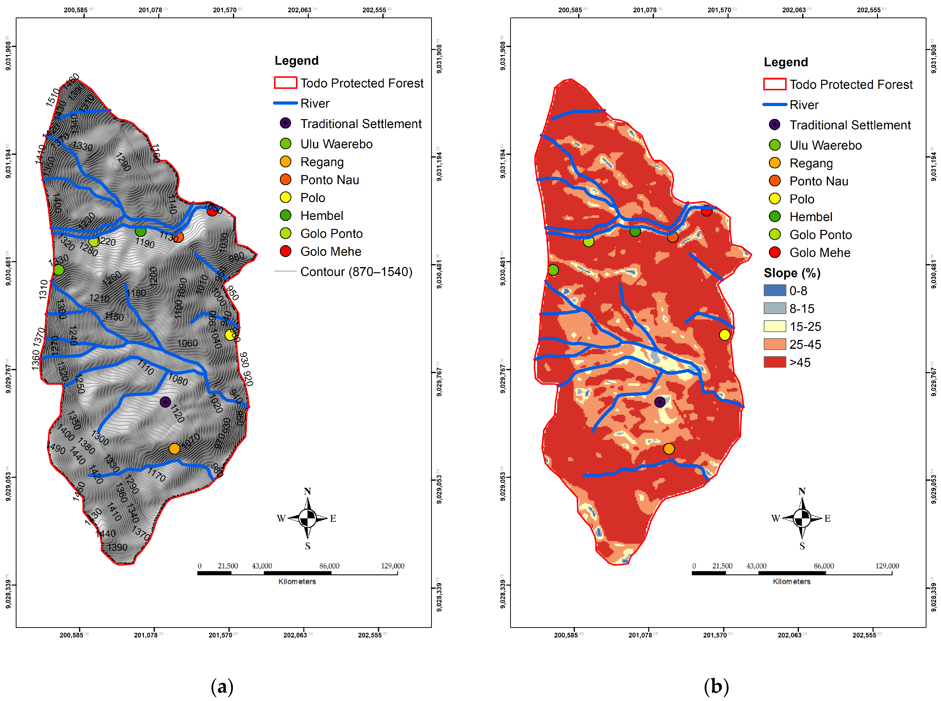
2.4. Contour, Slope and Elevation Analyses
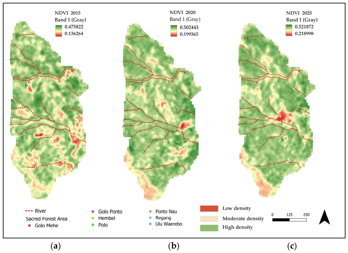
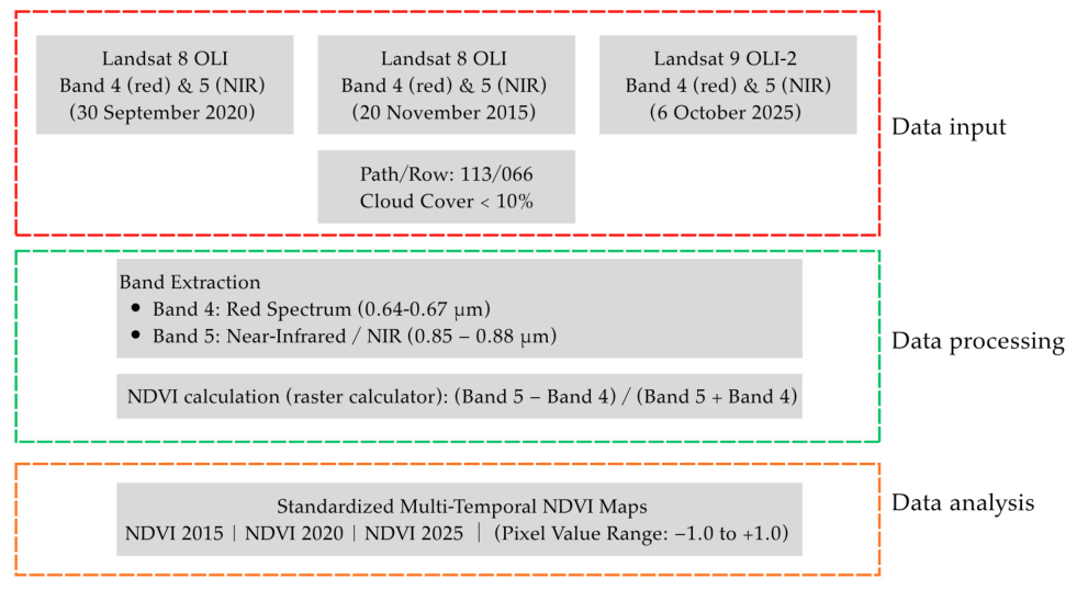
2.5. Normalized Difference Vegetation Index (NDVI)
2.6. Landscape Model Analysis
3. Results
3.1. General Condition and Culture History
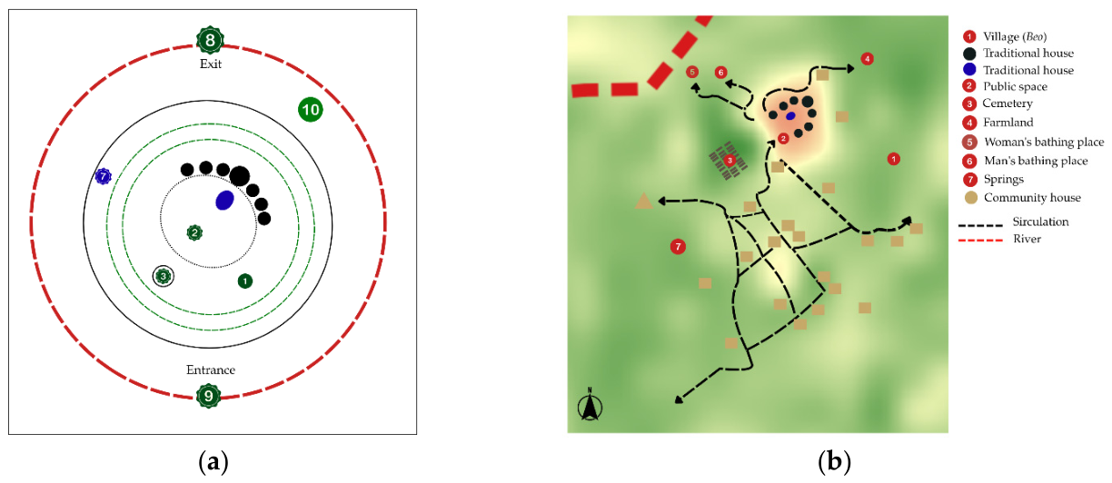
3.2. Landscape Elements and Spatial Configuration
3.3. Spatial and Geospatial Analysis
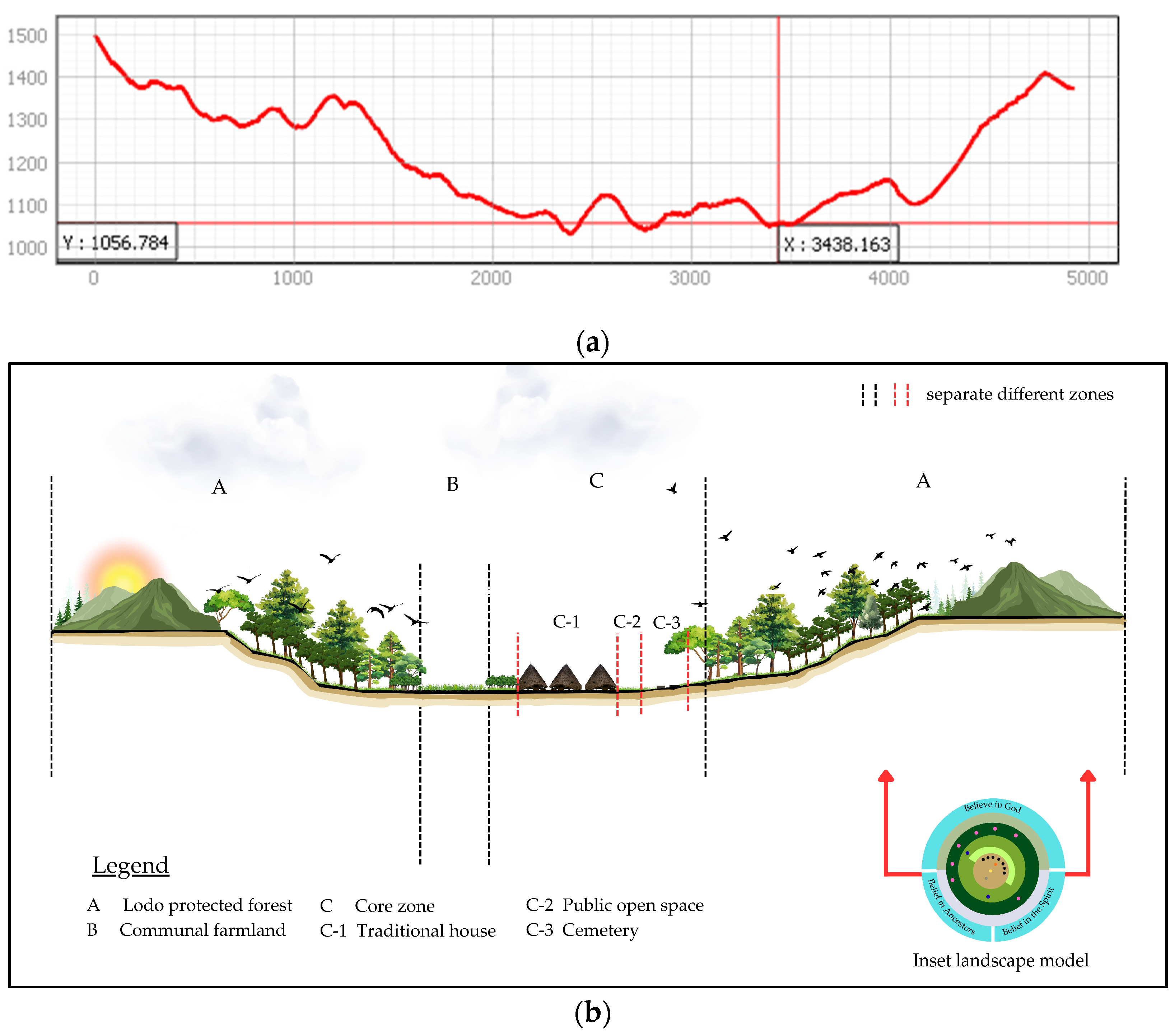
3.3.1. Topographic Adaptation
3.3.2. Forest Protected Area
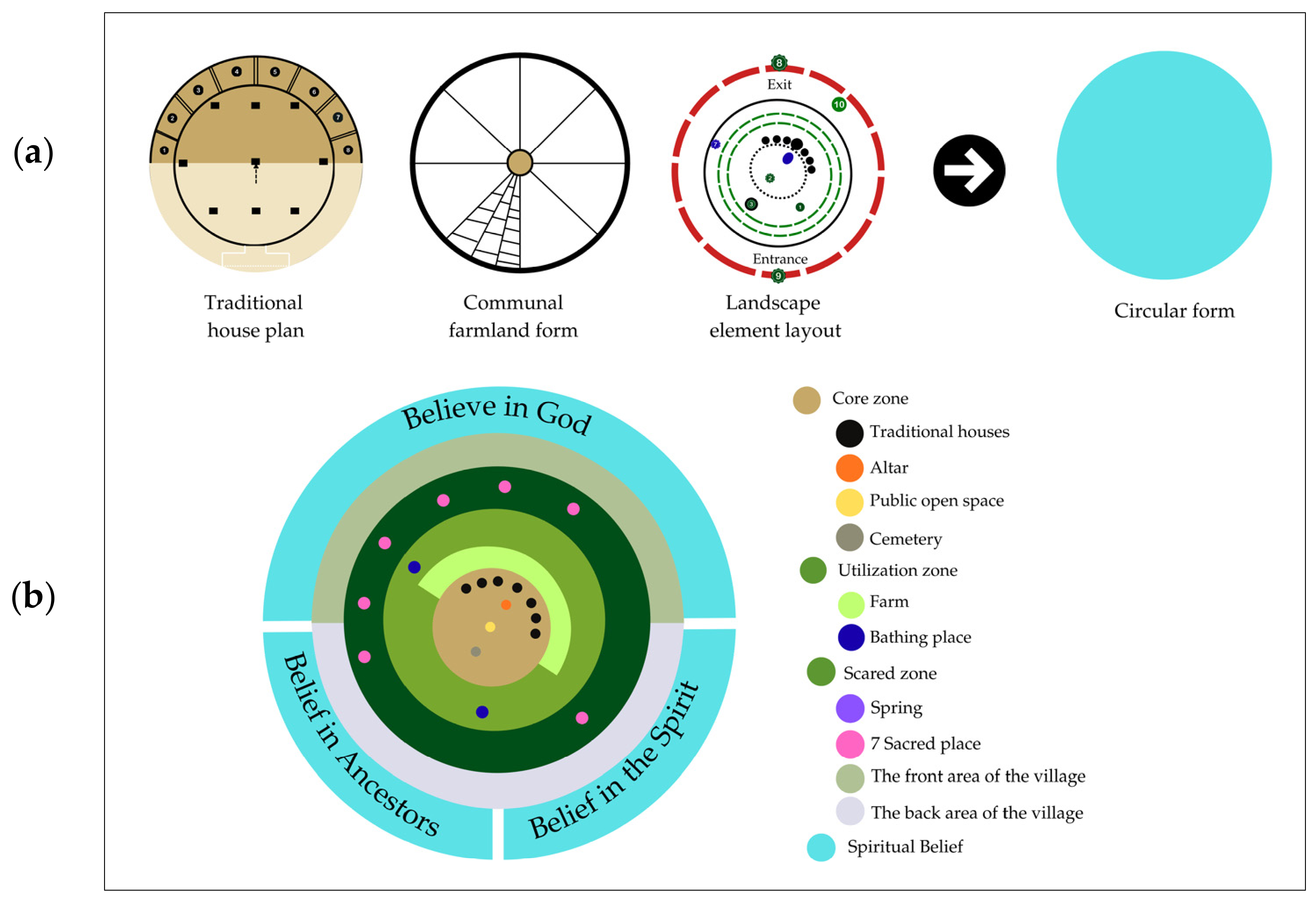
3.4. Landscape Model
3.5. Cultural Activities and Intensity of Space Usage
4. Discussion
4.1. Integrating Horizontal Concentricity and Vertical Hierarchy
4.2. Natural Hazards Mitigation and Ecological Resilience
5. Conclusions
Author Contributions
Funding
Data Availability Statement
Acknowledgments
Conflicts of Interest
References
- Aldyan, A.; Putri, K.A.; Aldyan, R.A.; Alasttal, A. Local wisdom-based environmental management policy in Indonesia: Challenges and implementation. J. Law Environ. Justice 2024, 2, 332–354. [Google Scholar] [CrossRef]
- Kissiya, E.; Biczó, G. Indigenous knowledge and environmental governance—A local wisdom-based approach in Indonesia (literature review). Különleges Bánásmód-Interdiszciplináris Folyóirat 2025, 11, 65–79. [Google Scholar] [CrossRef]
- Putri Baso, F.K.; Hasibuan, R.A.; Jong, A.F. Menelaah estetika ruang Nusantara pada rumah adat Waerebo. J. Vastukara 2025, 5, 59–69. [Google Scholar] [CrossRef]
- Danu, A.K.; Iku, P.F.; Warung, Y.E.; Sii, P.; Regus, M. Upaya internalisasi nilai kearifan lokal Masyarakat Waerebo sebagai ikon wisata Manggarai. J. SOLMA 2021, 10, 14–22. [Google Scholar] [CrossRef]
- Man, G.M.A.P.; Salura, P. An evaluation of the relationship between function, form, and architectural meaning of the traditional house Mbaru Niang in Wae Rebo village. ARTEKS J. Tek. Arsit. 2025, 10, 421–434. [Google Scholar] [CrossRef]
- Dominikus, W.S.; Madu, A.; Angelius, Z.; Wara, K. Ethno Mathematics at the Traditional House of Mbaru Niang Wae Rebo, Manggarai; ICEHHA: Ruteng, Indonesia, 2022. [Google Scholar] [CrossRef]
- Tarolli, P.; Straffelini, E. Agriculture in hilly and mountainous landscapes: Threats, monitoring and sustainable management. Geogr. Sustain. 2020, 1, 70–76. [Google Scholar] [CrossRef]
- Asrawijaya, E. Traditional ecological wisdom for the resilience of indigenous peoples in Indonesia. BESARI J. Soc. Cult. Stud. 2024, 1, 59–77. [Google Scholar] [CrossRef]
- Andari, D.W.T.; Mujiburohman, D.A.; Junarto, R.; Riyadi, R.; Aisiyah, N.; Farid, A.H. Local wisdom in the land system of Manggarai’s indigenous people, Indonesia. Int. Soc. Study Vernac. Settl. 2023, 10, 223–243. [Google Scholar] [CrossRef]
- Liu, S.; Wu, L.; Xiang, C.; Dai, W. Revitalizing rural landscapes: Applying cultural landscape gene theory for sustainable spatial planning in linpu Village. Buildings 2024, 14, 2396. [Google Scholar] [CrossRef]
- Qin, X.; Du, X.; Wang, Y.; Liu, L. Spatial evolution analysis and spatial optimization strategy of rural tourism based on spatial syntax model—A case study of Matao Village in Shandong Province, China. Land 2023, 12, 317. [Google Scholar] [CrossRef]
- Rizky, A.F.; Gunawan, A.; Manningtyas, R.D.T. Model lanskap permukiman tradisional masyarakat Gayo, Kabupaten Aceh Tengah, Provinsi Aceh. J. Lanskap Indones. 2025, 17, 122–129. [Google Scholar] [CrossRef]
- Asrina, M.; Gunawan, A.; Aris, M. Identification of Minangkabau Landscape Characters. IOP Conf. Ser. Earth Environ. Sci. 2017, 91, 012018. [Google Scholar] [CrossRef]
- Pratiwi, R.A.; Gunawan, A. Study of Lampungnese home garden design. IOP Conf. Ser. Earth Environ. Sci. 2017, 91, 012024. [Google Scholar] [CrossRef]
- Agustina, Y.; Gunawan, A. Study on Sundanese traditional home garden. In Ecological Aesthetics, Theory and Concept for Landscape and Environmental Design; IPB Press: Bogor, Indonesia, 2016; Volume 1, pp. 161–171. [Google Scholar]
- Librawan, R.; Gunawan, A.; Mugnisjah, W.Q. The ecodesign concept for the Palangka Raya City arterial road landscape based on the local wisdom of the Ngaju Dayak Tribe’s Culture. Tataloka 2021, 23, 12–38. [Google Scholar] [CrossRef]
- Rassing, A.R.T.; Gunawan, A.; Pratiwi, P. Agricultural landscape model based on the culture of the indigenous people of Tana Toraja, South Sulawesi. IOP Conf. Ser. Earth Environ. Sci. 2024, 1384, 012022. [Google Scholar] [CrossRef]
- Gunawan, A.; Mugnisjah, W.Q. Landscape model of the Uma Lengge traditional settlement, West Nusa Tenggara. Int. J. Conserv. Sci. 2024, 15, 1899–1912. [Google Scholar] [CrossRef]
- Istiqamah; Mugnisjah, W.Q.; Gunawan, A. Model design of traditional settlement of Sasak Limbungan, East Lombok Regency, West Nusa Tenggara. IOP Conf. Ser. Earth Environ. Sci. 2020, 501, 012038. [Google Scholar] [CrossRef]
- Yin, N.; Zuo, J.; Yang, M.; Yang, J.; Liu, S.; Wu, J. Spatio-temporal evolution of social-ecological system resilience in ethnic tourism destinations in mountainous areas and trend prediction: A case study in Wuling, China. Sci. Rep. 2025, 14, 23563. [Google Scholar] [CrossRef] [PubMed]
- Zhang, Y.; Zhang, L.; Gao, Y.; Yang, X.; Sun, W.; An, J.; Li, T. Assessing ecological risk from tourism in human-dominated landscapes: Integrating scenario modelling and nature-based strategies in eastern. Ecol. Indic. 2025, 181, 114365. [Google Scholar] [CrossRef]
- Auria, A.D.; Di Ruocco, I. An integrated isochrone-based geospatial analysis of mobility policies and vulnerability hotspots in the Lazio Region, Italy. ISPRS Int. J. Geo-Inf. 2025, 14, 395. [Google Scholar] [CrossRef]
- Della Spina, L.; Giorno, C. Cultural landscapes: A multi-stakeholder methodological approach to support widespread and hhared tourism development strategies. Sustainability 2021, 13, 7175. [Google Scholar] [CrossRef]
- Pranditha, I.D.G.A.S.; Gunawan, A.; Munandar, A. Balinese traditional home garden concept based-on traditional manuscript. Int. J. Conserv. Sci. 2021, 12, 1557–1568. [Google Scholar]
- Booth, N.K. Basic Elements of Landscape Architectural Design; Waveland Press: Long Grove, IL, USA, 1989. [Google Scholar]
- Nur, R.; Gunawan, A.; Pratiwi, P.I. Model of tradditional settlement landscape of Lakkang Island. Int. J. Conserv. Sci. 2022, 13, 1209–1222. [Google Scholar]
- Nugrahatama, D.; Gunawan, A.; Pratiwi, P.I. Landscape patterns of traditional settlements of the indigenous people of Tegaldeeng Kampong, Medalsari Village, Karawang Regency. J. Lanskap Indones. 2024, 16, 31–37. [Google Scholar] [CrossRef]
- Briggs, C.; Burfurd, I.; Duckham, M.; Guntarik, O.; Kerr, D.; McMillan, M.; San Martin Saldias, D. Bridging the geospatial gap: Sata about space and indigenous knowledge of place. Geogr. Compass 2020, 14, e12542. [Google Scholar] [CrossRef]
- Ayaa, D.D.; Kipterer, J.K. The role of indigenous technical knowledge and geographical information systems (GIS) in sustainable natural resource management around the Teso Community in Kenya. J. Ecol. Nat. Environ. 2018, 10, 97–107. [Google Scholar] [CrossRef]
- Taneo, M.; Madu, A. Implementation of Cultural Values of Traditional Houses in Learning. J. Intercult. Commun. 2023, 3, 14–27. [Google Scholar] [CrossRef]
- Marakhina, A.B.; Elpatsa, A. The meaning and symbolism of the Gonjong, a structural element of the roof of the traditional West Sumatran house of Rumah Gadang, in the context of semiotics. Manuscript 2024, 17, 161–167. [Google Scholar] [CrossRef]
- Jelahut, F.E.; Wahyudin, U.; Bajar, A. Memahami kearifan lokal masyarakat Manggarai NTT dalam melindungi lingkungan. In Komunikasi Lingkungan Berbasis Kearifan Lokal; UNPAD: Jawa Barat, Indonesia, 2020; p. 44. [Google Scholar]
- Perdana, M.R. Tata spasial permukiman tradisional Manggarai berdasar ritual Penti di Kampung Waerebo di Pulau Flores. Ruang Sp. 2016, 3, 173–200. [Google Scholar]
- Rada, I.G.; Gunawan, A.; Hadi, A.A. Landscape model of Wologai Traditional Village based on Lio Tribe. J. Lanskap Indones. 2026, 18, 115–125. [Google Scholar] [CrossRef]
- Tovbych, V.; Viazovska, A.; Kryvoruchko, Y. Place and people: Landscape as a basis of development and preservation of cultural identity. Tech. Trans. 2018, 5, 65–72. [Google Scholar] [CrossRef]
- Lavrenova, O.A. Spaces and Meanings: Semantics of The Cultural Landscape, 1st ed.; Springer: Cham, Switzerland, 2019. [Google Scholar] [CrossRef]
- Denar, B.; Juhani, S.; Riyanto, A. Ecotheological dimensions of Roko Molas Poco in the tradition of making traditional houses of the Manggarai comunity—NTT. J. Asian Orientat. Theol. 2021, 3, 59–88. [Google Scholar] [CrossRef]
- Sarmiento-mateos, P.; Arnaiz-schmitz, C.; Herrero-j, C.; Pineda, F.D.; Schmitz, F. Designing protected areas for social—Ecological sustainability: Effectiveness of management guidelines for preserving cultural landscapes. Sustainability 2019, 11, 2871. [Google Scholar]
- Zhu, H. Understanding and optimizing Cultural-Ecological patterns in protection Zones: A case study from Qiang CEPZ. Ecol. Indic. 2025, 179, 114084. [Google Scholar] [CrossRef]
- Mally, E.I.D.J.; Bustan, F.; Bria, F.M.U.; Ngebos, F.F. The characteristics of traditional house as a cultural patrimony of clan in Manggarai society (semiotic analysis). Soc. Sci. Hum. Res. Bull. 2025, 2, 58–63. [Google Scholar] [CrossRef]
- Faisal, G.; Ikaputra, I. Tipologi permukiman di Indonesia: Penjejangan, dikotomi, konteks sosial dan spasial. Langkau Betang J. Arsit. 2022, 9, 141. [Google Scholar] [CrossRef]
- Tenjei, T.E.; Wabwire, E.; Norvy, P. Indigenous cultural practices and environmental conservation: A case study of Ogiek community of Mau Forest of Kenya. Int. J. Cult. Relig. Stud. 2022, 3, 1–24. [Google Scholar] [CrossRef]
- Uju, G.F.; Bhuja, P.; Boro, T.L. Kearifan lokal masyarakat dalam pengelolaan hutan lindung di kampung Wae Rebo, Desa Satar Lenda, Kabupaten Manggarai. J. Biotropikal Sains 2019, 16, 1–11. [Google Scholar]
- Iswandono, E.; Zuhud, E.A.M.; Hikmat, A.; Kosmaryandi, N. Traditional land practice and forest conservation: Case study of the Manggarai Tribe in Ruteng Mountains, Indonesia. Komunitas 2016, 8, 256–266. [Google Scholar] [CrossRef]
- Solosumantro, H.; Hadut, A.D. Kajian filsafat agama dalam tradisi Barong Wae di Manggarai. Proc. Natl. Conf. Indones. Philos. Theol. 2024, 2, 41–55. [Google Scholar] [CrossRef]
- Bhagyanathan, A.; Dhayanithy, D. Sacred groves and riparian conservation: Nature-based solutions towards local climate adaptation in the Malabar Coast of India. Landsc. Res. 2025, 50, 598–621. [Google Scholar] [CrossRef]
- Hakim, A.L.; Saputra, D.D.; Tanika, L.; Kusumawati, I.A.; Sari, R.R.; Andreotti, F.; Bagbohouna, M.; Abdurrahim, A.Y.; Wamucii, C.; Lagneaux, E.G.; et al. Protected spring and sacred forest institutions at the instrumental—Relational value interface. Curr. Opin. Environ. Sustain. 2023, 62, 101292. [Google Scholar] [CrossRef]
- Rathore, M.S. Sacred groves: A bastion of biodiversity and cultural heritage. Int. Educ. Res. J. 2024, 10, 1–4. [Google Scholar] [CrossRef]
- Haipeng, Z.; Hanchu, L.I.U.; Yong, S.U.N.; Renwei, H.E. Spatial differentiation characteristics of human settlements and their responses to natural and socioeconomic conditions in the marginal zone of an uninhabited area, Changtang Plateau, China. Chin. Geogr. Sci. 2022, 32, 506–520. [Google Scholar] [CrossRef]
- Haryani; Barlian, E.; Tela, I.N.; Aditia, E.; Putra, A. GIS-based analysis of slope, landslide and flood hazards, and land use integrated with indigenous knowledge in Nagari Sijunjung, Indonesia. Geogr. Tech. 2025, 20, 336–353. [Google Scholar] [CrossRef]
- Li, Y.; Du, J.; Id, D.R.; Yi, C. Spatio-temporal distribution and evolution of the Tujia traditional settlements in China. PLoS ONE 2024, 19, e0299073. [Google Scholar] [CrossRef] [PubMed]
- Dantani, A. Determination of forest health using remote sensing techniques in Gashaka-Gumti National Park, Northeast, Nigeria. Afr. J. Environ. Nat. Sci. Res. 2024, 7, 119–138. [Google Scholar] [CrossRef]
- Gupta, S.K.; Pandey, A.C. Spectral aspects for monitoring forest health in extreme season using multispectral imagery. Egypt. J. Remote Sens. Sp. Sci. 2021, 24, 579–586. [Google Scholar] [CrossRef]
- Kurniawati, D.P.M.; Hastjarjo, S.; Slamet, Y. Communication of rituals and traditional ceremonies Dayak Ngaju Community in Central Kalimantan. Formosa J. Sci. Technol. 2024, 3, 103–118. [Google Scholar] [CrossRef]
- Lake, R.C.; Purbadi, Y.D.; Florianus, H. Identification and orientation on spatial arrangement of Wajo Traditional Village, Keo Tengah, Nagekeo Regency. Local Wisdom 2020, 12, 19–30. [Google Scholar] [CrossRef]





| Landscape Features | Basic Landscape Elements a | Explanation |
|---|---|---|
| Natural landscape | (1) Forest, (2) Farm, (3) Hydrology, (4) Plants (5) Land use | The location, form, and function of elements in space and the cultural activities of society |
| Man-made landscape | (5) Building (Landform), (6) Circulation | |
| Social—Culture | (7) Belief, (8) Kinship, (9) Ceremony |
| Respondent Category | Sampling Technique | Interview Method | Quick Questionnaire |
|---|---|---|---|
| Custom leader (Tu’a Golo) | Purposive Sampling | Deep and Formal (Inside Mbaru Niang) |
|
| Traditional elder (Tua Panga) | Snowball Sampling | In-depth and Semi-Structured |
|
| Local Guide | Purposive Sampling | Semi-Structured |
|
| No | Slope Class (%) | Category |
|---|---|---|
| 1 | 0–8 | Flat |
| 2 | 8–15 | Gentle Slope |
| 3 | 15–25 | Moderately Steep |
| 4 | 25–45 | Steep |
| 5 | >45 | Very Steep |
| Landscape Feature | Landscape Element | Element Zoning | Explanation |
|---|---|---|---|
| Natural Landscape | |||
|
| Utilization zone | Forests that can be utilized by the community |
| Sacred zone | 7 sacred sites that are vital areas and habitats for endemic fauna | |
|
| Utilization zone | Communal farmland area close to residential areas |
|
| Sacred zone | Located northwest of the settlement |
| Utilization zone | Sosor, divided by gender, male sosor and female sosor, is located in the southwest | |
|
| Utilization zone | Trees used as the main material for traditional houses |
| Man-made Landscape | |||
|
| Core zone | Mbaru Niang consists of one main house and six residential houses. |
| Core zone | Place for ritual offerings and located in front of traditional house | |
| Core zone | Located in the southwest with a higher elevation than the settlement | |
|
| Core zone | Circular in shape and located in the center of the settlement |
|
| Sacred zone | The single entrance located in the south serves as the physical and symbolic boundary of the settlement |
| Sacred zone | Located northeast within the Todo protected forest | |
| Year | Min | Max | Mean | StdDev | Landscape & Socio-Ecological Dynamics |
|---|---|---|---|---|---|
| 2015 | 0.136 | 0.475 | 0.36 | 0.049 | Post-UNESCO stabilization phase: Initial restoration period; low index base with wider spatial variation. |
| 2020 | 0.199 | 0.502 | 0.409 | 0.038 | Established cultural tourism: Customary zoning effectively mitigates infrastructure expansion; uniform canopy recovery. |
| 2025 | 0.219 | 0.522 | 0.429 | 0.039 | Current resilient ecosystem: Continued canopy maturation; minimal bare soil surface; high system stability. |
| Cultural Activities | Landscape Elements | ||||||||
|---|---|---|---|---|---|---|---|---|---|
| (1) | (2) | (3) | (4) | (5) | (6) | (7) | (8) | (9) | |
|  | | |||||||
| | | |||||||
| | | | ||||||
| | | | | |||||
| | | | ||||||
| | | | | | | | | |
| | | | ||||||
| | | | ||||||
| | | |||||||
| | | | ||||||
Disclaimer/Publisher’s Note: The statements, opinions and data contained in all publications are solely those of the individual author(s) and contributor(s) and not of MDPI and/or the editor(s). MDPI and/or the editor(s) disclaim responsibility for any injury to people or property resulting from any ideas, methods, instructions or products referred to in the content. |
© 2026 by the authors. Licensee MDPI, Basel, Switzerland. This article is an open access article distributed under the terms and conditions of the Creative Commons Attribution (CC BY) license.
Share and Cite
Gunawan, A.; Rada, I.G.M.; Hadi, A.A.; Manningtyas, R.D.T.; Nafar, S. Landscape Model of Waerebo Village: Topographic Adaptation & Indigenous Spatial Patterns (Horizontal–Vertical) Based on Local Culture. Heritage 2026, 9, 255. https://doi.org/10.3390/heritage9070255
Gunawan A, Rada IGM, Hadi AA, Manningtyas RDT, Nafar S. Landscape Model of Waerebo Village: Topographic Adaptation & Indigenous Spatial Patterns (Horizontal–Vertical) Based on Local Culture. Heritage. 2026; 9(7):255. https://doi.org/10.3390/heritage9070255
Chicago/Turabian StyleGunawan, Andi, Ignasia Germania M. Rada, Akhmad Arifin Hadi, Rosyi Damayanti Twinsari Manningtyas, and Sholihin Nafar. 2026. "Landscape Model of Waerebo Village: Topographic Adaptation & Indigenous Spatial Patterns (Horizontal–Vertical) Based on Local Culture" Heritage 9, no. 7: 255. https://doi.org/10.3390/heritage9070255
APA StyleGunawan, A., Rada, I. G. M., Hadi, A. A., Manningtyas, R. D. T., & Nafar, S. (2026). Landscape Model of Waerebo Village: Topographic Adaptation & Indigenous Spatial Patterns (Horizontal–Vertical) Based on Local Culture. Heritage, 9(7), 255. https://doi.org/10.3390/heritage9070255